Preferred route for the Arkansas Valley Conduit via Reclamation FromThe Pueblo Chieftain (Chris Woodka):
A $939,000 contract for utility location and land rights acquisition support for the Arkansas Valley Conduit has been awarded to MWH Americas by the Bureau of Reclamation. The contract is another step toward the eventual construction of the conduit, which will bring clean drinking water to 50,000 people in 40 communities east of Pueblo.
Work begins this month and is expected to take one year to complete.
The 130-mile-long pipeline will be built from Pueblo Dam to Lamar, with spurs to communities along the way, including St. Charles Mesa, Avondale, Crowley County, Otero County, Bent County, Lamar and Eads in Kiowa County.
“The objective of this contract is to provide Reclamation with utility locations, current ownership information, legal descriptions and encumbrances affecting the parcels along the route,” said Jacklynn Gould, Eastern Colorado Area Manager for Reclamation.
The contractor also will prepare a preliminary land acquisition plan and update GIS data.
The Arkansas Valley Conduit is part of the Fryingpan-Arkansas Project, authorized in 1962. It was never built because of the expense, now estimated at $400 million. A 2009 federal law authorized revenues from Reclamation contracts as a repayment source for the conduit, however.
The Southeastern Colorado Water Conservancy District is the local sponsor of the project.
More Arkansas Valley Conduit coverage here and here.
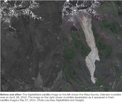
Grand Mesa mudslide before and after via The Denver Post From the Glenwood Springs Post Independent (Chad Thatcher):
As first responders to arrive at the slide on May 26, Frank Kochevar, Mesa County Public Works’ professional surveyor, and Tim Hayashi, Mesa County Public Works’ engineer and field commander, remember getting a glimpse of the area, and uttering the words, “Oh, my God.” No one had seen a slide of this magnitude — ever.
After nearly three and half months, Hayashi and Kochevar traveled to the slide dozens of times, setting up surveillance equipment, clearing roads, building trails and juggling 14 different organizations that have a stake in the outcome. From CMU and U.S. Geological Survey (USGS) geologists to landowners and Mesa County officials, a rather fragile landscape has created a thoughtful and organized crew of individuals working every day to better understand the event.
Sensitive monitors have recorded every movement around the slide, evacuation routes have been established, maps have been rewritten, gas lines have been shut down, roads reconstructed, cell lines installed and lines of communication set up. All this collaboration is designed to answer the one question on everyone’s mind: Will a landslide of this magnitude happen again? And if so, where, when and how?
After meeting with a host of experts, the definitive answer is yes, there will be another landslide on the Mesa — but as to when, that is all speculation. No one could have predicted the West Salt Creek Slide, its size and destructive force. However, in the aftermath, all eyes turn to similar terrain that flanks the side of the Grand Mesa.
Rex Cole, a geology professor at Colorado Mesa University, explained the unique geography and the complicated history that encompassed the slide area. The region has a long history of landslides; in fact, landslide zones surround the entire Grand Mesa. Gravity has been exerting its force on the mesa for eons, contributing to a form of erosion called mass wasting. The term used by geologists describes the movement of soil and rocks down the side of a mountain. A quick examination of the slide area shows mostly a greenish shale rock from the Green River formation, a kind of fine-grained sedimentary rock that literally crumbles in your hand. It’s not the best foundation, especially on the side of a slope.
During the two days prior to the incident, over an inch of water fell in the area. Jeff Coe, with USGS, said the rain added to the “juiciness” of the slide. Adding an intense rain on snow event to an unstable surface creates the perfect recipe for a landslide.
Geologists are still concerned about the West Salt Creek slide area, especially with the formation of a new 190-acre-feet lake at the headwall. The lake continues to fill and is expected to breach the spillway this spring. At that point the entire headwall has the potential to erode away, sending a wall of water down the slide path. Residents of Collbran are concerned about the influx of water, but Bill Edwards of the U.S. Forest Service concluded that the amount of water is consistent with spring runoff and the watershed should absorb the excess. Still, nearby residents and businesses are preparing for the inevitable, the re-emergence of West Salt creek somewhere along its historic path.
Jerald Hawkins, owner of the property, and Oxy, an oil and gas exploration company, are taking a proactive stance by digging a potential drainage where the creek can safely enter and reconnect with its historical waterway. The slide path narrowly missed the Oxy gas pad located on the Hawkins property. Oxy immediately responded to the incident by shutting down all activity at the site.As first responders to arrive at the slide on May 26, Frank Kochevar, Mesa County Public Works’ professional surveyor, and Tim Hayashi, Mesa County Public Works’ engineer and field commander, remember getting a glimpse of the area, and uttering the words, “Oh, my God.” No one had seen a slide of this magnitude — ever.
After nearly three and half months, Hayashi and Kochevar traveled to the slide dozens of times, setting up surveillance equipment, clearing roads, building trails and juggling 14 different organizations that have a stake in the outcome. From CMU and U.S. Geological Survey (USGS) geologists to landowners and Mesa County officials, a rather fragile landscape has created a thoughtful and organized crew of individuals working every day to better understand the event.
Sensitive monitors have recorded every movement around the slide, evacuation routes have been established, maps have been rewritten, gas lines have been shut down, roads reconstructed, cell lines installed and lines of communication set up. All this collaboration is designed to answer the one question on everyone’s mind: Will a landslide of this magnitude happen again? And if so, where, when and how?
After meeting with a host of experts, the definitive answer is yes, there will be another landslide on the Mesa — but as to when, that is all speculation. No one could have predicted the West Salt Creek Slide, its size and destructive force. However, in the aftermath, all eyes turn to similar terrain that flanks the side of the Grand Mesa.
Rex Cole, a geology professor at Colorado Mesa University, explained the unique geography and the complicated history that encompassed the slide area. The region has a long history of landslides; in fact, landslide zones surround the entire Grand Mesa. Gravity has been exerting its force on the mesa for eons, contributing to a form of erosion called mass wasting. The term used by geologists describes the movement of soil and rocks down the side of a mountain. A quick examination of the slide area shows mostly a greenish shale rock from the Green River formation, a kind of fine-grained sedimentary rock that literally crumbles in your hand. It’s not the best foundation, especially on the side of a slope.
During the two days prior to the incident, over an inch of water fell in the area. Jeff Coe, with USGS, said the rain added to the “juiciness” of the slide. Adding an intense rain on snow event to an unstable surface creates the perfect recipe for a landslide.
Geologists are still concerned about the West Salt Creek slide area, especially with the formation of a new 190-acre-feet lake at the headwall. The lake continues to fill and is expected to breach the spillway this spring. At that point the entire headwall has the potential to erode away, sending a wall of water down the slide path. Residents of Collbran are concerned about the influx of water, but Bill Edwards of the U.S. Forest Service concluded that the amount of water is consistent with spring runoff and the watershed should absorb the excess. Still, nearby residents and businesses are preparing for the inevitable, the re-emergence of West Salt creek somewhere along its historic path.
Jerald Hawkins, owner of the property, and Oxy, an oil and gas exploration company, are taking a proactive stance by digging a potential drainage where the creek can safely enter and reconnect with its historical waterway. The slide path narrowly missed the Oxy gas pad located on the Hawkins property. Oxy immediately responded to the incident by shutting down all activity at the site…
In general, unless gravity mysteriously disappears, landslides will continue to shape the landscape; and wherever humans interact with these landscapes, disaster can occur. For example, the state of Washington’s deadly Oso landslide killed 43 people on March 22, taking out an entire rural neighborhood. Despite its isolated location, tragedy also struck at the West Salt Creek slide. While investigating a small landslide that had blocked an irrigation canal, Wes Hawkins, 46, Clancy Nichols, 53, and his son, Danny Nichols, 24, were evidently in the path of the second and more destructive landslide. Their bodies are still missing…
As Grand Mesa residents prepare for winter and the eventual spring runoff, experts are also looking at positive aspects of the West Salt Creek slide. As Bill Edwards of the U.S. Forest Service points out, from an ecological perspective, area experts have an amazing opportunity to observe and monitor the area as life again takes hold. Already flowers and plants are starting to take root in the area.
Up close, the grayish, topsy-turvy surface of Colorado’s largest recorded rock avalanche yields small surprises that hint at the land as it was before: snail shells, Douglas fir cones, charcoaled wood, nubs of aspen shoots and intermittent clods of rich, brown topsoil.
They’re all tucked into 50 million tons of rock and debris that rumbled and raced down this draw on the Grand Mesa on May 25.
This week, many of the experts who have been studying the slide, along with the county and national officials who have been monitoring it and the landowners impacted by it — one an uncle of a slide victim — walked out on this slide together for the first time.
They shared a thought as they picked their way over the slide’s steep, spongy surface in a whipping wind: They never expect to see anything of this magnitude in this state again in their lifetimes.
“In Colorado, this is historically unprecedented as far as I can tell,” said Jeff Coe, a geologist with the U.S. Geological Survey.
Those watching for the next move of this mass often refer to it as a living entity — a “monster” that churned up pulses of pulverized rock, twisted giant chunks of earth and now hides an underbelly of soaked earth beneath slide matter as deep as 130 feet.
It has proven its danger, even in a sparsely populated area of ranch houses and hayfields, by claiming the lives of Wes Hawkins, Clancy Nichols and Danny Nichols.
The slide’s continuing danger is focused in the 190-acre lake that formed when a massive block of cliffside fell and tilted backward turning into an iffy dam for runoff. The lake is already leaking. That is evident in the smaller seep ponds forming below.
There is no dispute among the experts that the lake will double in size next spring and overflow.
“It is not a question of if, but when,” said Tim Hayashi, an engineer for Mesa County and the field commander for the dozen-plus agencies still studying and monitoring the slide.
When the lake tops, it could form a new creek channel down the middle of the slide. Or it could flow out haphazardly over the the giant hummocks of earth in the middle of the slide path and start a new debris movement. That movement could take debris into an irrigation canal or a creek. It could end up on an Occidental Petroleum Corp. well pad that the initial slide barely skirted.
Occidental is preparing for any slide movement in that direction by abandoning part of the well pad closest to the slide and building berms and a new drainage to divert water or mud.
The need for such measures is underscored by other factors pointed out by the experts this week.
“Those escarpments are a danger, ” said Colorado Geological Survey geologist Jon White as he pointed to a tree-lined ridge that hides large swaths of fractured earth. That could be the next to go.
Coe said the increasing incidence of rain falling on snow — a phenomenon he thinks contributed to this slide — causes snow to melt faster and puts more pressure on unstable rock formations. He expects more of that in more locations with climate change.
For now, monitors on the slide have allowed those living in the vicinity to breath a little easier this summer. But whether the devices will stay put during the winter snows is in doubt.
Hayashi said if the monitors are knocked out, he will climb back up this slide in the early spring even though the danger will be greatly magnified then.
“No one wants to be there,” Hayashi said. “But you just have to do it.”
Government, industry and scientific experts who recently toured the West Salt Creek rock avalanche area agree that fracking is not to blame for setting off the deadly slide.
The fact that the craggy lower edge of the rock avalanche on the Grand Mesa towers over and curves around a drilling pad where Oxy USA has a gas well is not relevant, they say.
“From my perspective, there is absolutely no evidence fracking was involved in any way,” said U.S. Geological Survey geologist Jeff Coe, who has spent the past 3½ months mapping and studying the slide.
“It was a rain event,” said Jon White, with the Colorado Geological Survey, as he looked out over the mass of pulverized rock that roared down a draw May 25 and buried three local men.
Oxy narrowly escaped the complicated and unusual problem of having a drilling operation buried by tons of debris. But the company, which has wells dotting the Plateau Creek area on the mesa, did not escape claims that drilling activities had caused the slide.
When the first aerial images of the rock avalanche were released, the blaming fingers of online observers immediately pointed at the drilling pad at the toe of the slide. The proximity was taken as proof that fracking — drilling and injecting fluid into the ground at a high pressure to release natural gas — had made the area unstable and caused 39 million cubic yards of earth to move.
Rex Cole, a Colorado Mesa University geology professor who has studied the formations of the Grand Mesa for four decades, underscored the government geologists’ opinions with charts and maps.
They depict the mesa as a sort of layer cake with 10 million-year-old lava rock capping softer slanted layers of shale, basalt and limestone.
Cole described the Green River layer of rock where the slide occurred as being “squishy” and easy to break off and cave in with heavy rain and seeping groundwater.
“There is a lot of science pointing in the other direction,” he said of claims that fracking caused the earth to move. “You get it wet, and down it comes.”
Fracking in the slide area ended in 2008. It took place in the Williams Fork formation more than a mile below ground and more than 2 miles from where the slide began, near the mesa’s top.
There were no injection wells associated with the drilling in that area. The fracking fluids for Oxy’s wells were stored in tanks.
About 300 to 500 gallons of that fluid was hauled out in trucks in the wake of the slide, said Chris Clark of Oxy USA.
Oxy moved equipment on the well pad and abandoned the end of the pad closest to the slide. Clark said the company is building a berm and drainage to prepare for the possibility that the slide could let go again in the spring.
The water treatment process
Here’s the release from the Environmental Protection Agency:
Today the U.S. Environmental Protection Agency (EPA) continues its commitment to improving America’s drinking water by providing over $8 million to create two national centers for research and innovation in small to medium sized drinking water systems.
“These centers will help to develop innovative and practical solutions for challenges faced by smaller drinking water systems, which make up the majority of public water systems in the United States,” said Lek Kadeli, Acting Assistant Administrator for EPA’s Office of Research and Development. “Providing cost effective solutions to help these systems deliver safe, high quality drinking water will help improve the health, economy and security of our nation’s communities.”
The recipients are the University of Colorado Boulder’s Design of Risk Reducing, Innovative Implementable Small System Knowledge (DeRISK) Center [ed. emphasis mine], and the University of Massachusetts Amherst’s Water Innovation Network for Sustainable Small Systems (WINSSS) Center. These two EPA funded centers will develop and test advanced, low cost methods to reduce, control, and eliminate groups of water contaminants that present challenges to communities worldwide.
Ninety seven percent of the nation’s roughly 160,000 public water systems serve fewer than 10,000 people each. These drinking water systems face many obstacles including limited resources, aging infrastructure, and complying with a variety of regulations These centers will help strengthen the technical, managerial, and financial capacities of drinking water providers throughout the country. Both centers will collaborate with a range of stakeholders to support problem-oriented research on groups of water contaminants and their origins. This research marks a move towards developing trans-disciplinary results that will be nationally acceptable and applicable.
These grants, part of EPA’s research on safe and sustainable drinking water, support the development of water clusters– networks of businesses, researchers, and others involved in water technology. Colorado and Massachusetts are both home to water cluster organizations. These organizations are leading the way in developing cutting-edge technologies and bringing them to the market, where they can solve water challenges that threaten health and daily activities while promoting technological innovation and economic growth.
“High and dry is not a water plan,” Beauprez responded to a question about water storage. “We simply must put a shovel in the ground.”
Saying he supports building water storage, no question, Beauprez contended that regulation gets in the way of building the projects Coloradans need. “A governor needs to lead on behalf of the people to eliminate regulatory hurdles, not add to them,” he said.
Hickenlooper countered that any big water storage project will take decades to complete and that “Every conversation has to start with conservation.” He also declined to take a position on the Northern Integrated Supply Project, a proposal to build reservoirs on the northern Front Range. “I’m not allowed to take — if I took a stand on NISP, it would jeopardize the entire federal process,” he said.
“On my watch,” Beauprez rebutted, “we’re going to build”
“Water is essential to Colorado’s quality of life and economy, but our ability to maintain those values will be challenged by a growing population, increasing demands for water, and limited supplies of this precious resource.”
These words appear on the Colorado Water Conservation Board’s website, describing the need for and purpose of the proposed Colorado Water Plan, which is to be drafted by the end of 2014 under an executive order signed by Gov. John Hickenlooper in May 2013.
Our goal for the water plan is to provide a path forward for providing Coloradans with the water we need in the future while seeking to maintain such divergent values as healthy watersheds and environment, robust recreation and tourism economies, vibrant and sustainable cities and viable and productive agriculture.
Colorado’s Water Plan will build on eight years of extremely valuable water supply planning work by the Statewide Water Supply Initiative, the Inter-Basin Compact Committee and the nine Basin Roundtables, one for each of the major watersheds in the state.
In 2014, the Colorado General Assembly passed Senate Bill 14-115, which also recognized the need to engage the general public in the water planning process by gathering input through a series of public meetings in all the major river basins of Colorado. SB-115 directs the legislature’s Interim Water Resources Review Committee to convene these meetings, gather public input and provide comment on the draft water plan by Nov. 1.
The next of these public meetings is scheduled for Tuesday from 9 a.m. to noon at the Bud Werner Memorial Library in Steamboat Springs. This meeting is for residents of the Yampa and White river basins. I invite and encourage all residents of Northwest Colorado, from Steamboat to Rangeley, to attend this important meeting.
The WRRC recognizes that water issues inherently involve competing values that cannot all be resolved through technological or technical fixes. Different groups bring different values to the conversation. There is no “right” way to balance these competing interests and values. Through SB-115, the WRRC is asking the public to help make Colorado’s Water Plan a better document that seeks to represent the values of all state residents.
The WRRC also recognizes that the Colorado Water Plan will identify difficult choices and tradeoffs that will need to be made to plan for and create a sustainable water future. SB-115 envisions a public process that lays out these choices and tradeoffs facing Colorado and seeks to find a way through public input to navigate the difficult issues that lie ahead.
Sean Cronin and John McClow at the 2014 CFWE President’s Award Reception
When asked back in January of 2014 to put something together for Coyote Gulch I responded “am really short on time, my calendar frees up in March”. Well spring came and went, summer was a blur and now it is a full year since the devastating floods of September 2013. To be honest, if I wrote something in January, I think it would have been a bit pessimistic, as often times the recovery efforts were all consuming and really challenged any sense of hope. Ironic that it was the workload of the flood recovery that prevented me from writing and it was the flood that taught me yet another lesson, let things ferment and breath; given time even dire situations will eventually show you an encouraging future.
In September 2013, St. Vrain Creek experienced a catastrophic flood event which uprooted roadways, severely eroded private property, ruined homes, dramatically changed the creek corridor, and significantly damaged or destroyed public and private raw water infrastructure. Because there were limited federal, state and local jurisdictions to modify the post-flood stream condition, it became clear to many that private/public partnerships and multi-agency cooperation was critical for a successful recovery.
During the early weeks of the September 2013 Flood recovery, repairs were occurring in some locations, though in other areas property owners were asking “who is going to fix this?” The St. Vrain and Left Hand Water Conservancy District immediately recognized that the property owners’ rights needed to be a top priority. However, the scale of the flooding disaster and the interconnectivity of a living steam and associated ecosystem presented some financial and interdependency challenges. For example, it was not a stretch to imagine that there would likely be instances of individual efforts to restore specific segments of the stream that would then create problems downstream.
To minimize recovery challenges and maximize limited resources, many agencies, including Boulder County, City of Longmont, Town of Lyons, and the St. Vrain and Left Hand Water Conservancy District, promoted and implemented a strategy of collaboration. The collaboration along St. Vrain Creek started in the weeks following the flood and was quickly viewed by impacted citizens as safe, un-bureaucratic, nimble, and effective. In the months to follow, the Colorado Water Conservation Board (CWCB) provided significant financial assistance to ditch companies, in addition to numerous agencies for the furtherance of collaboration. Today these collaborative efforts are now known as “Coalitions”, and one is occurring in each of the flood impacted tributaries of the South Platte River.
Through vision, leadership, hard work, multi-agency and nonprofit support, and Ditch Company and property owner persistence the recovery effort has far surpassed the expectations of many who stood in awe of the flood ravaged areas. For example, within the boundaries of St. Vrain and Left Hand Water Conservancy District (DWR District 5) 44 of the 94 local ditches suffered damaged infrastructure from the flood at an estimated cost of $18.4M.
Through FEMA, CWCB, and grants administered by Northern Water, financial assistance was provided and as of August 28, 2014, 91% of the 44 damaged ditches are now back online, with 93% expected back online after 2014. Furthermore, many ditch companies recognized the need to rebuild their infrastructure with consideration given to the ecosystem and to design elements that would withstand future high-flow events. In the St. Vrain Creek alone, there are three new diversions that pre-flood were fish impediments, and are now fish passable, with an additional four diversions under consideration or design. Although the collaborative Coalitions didn’t lift a shovel, their collective expertise, continual internal and external communications, and identification of financial and technical resources played a key role in the recovery.
A full report and executive summary of the ditch infrastructure repairs, maps, and photos are available on the website of St. Vrain and Left Hand Water Conservancy District (http://www.svlhwcd.org), under the “2013 Flood” tab.
One year later, the work is still not complete. Each of the Coalitions are actively working on producing their own watershed specific “Master Plans” that when complete will promote a holistic healthy riparian corridor and a stream system that will be better able to handle future floods, while preserving critical infrastructure, including that used for agricultural production. If successful, these Master Plans will be embraced by affected property owners, water rights owners, ditch companies, and government agencies.
As water mangers we are trained to manage around the extremes of drought and spring runoff. September 2013 reminded me that Mother Nature is letting us manage, but when she wants to change the rules, we are pretty much at her mercy. It is said that over time memories of disasters wane resulting in some people rebuilding in a manner that does not mitigate future disaster risk. Time will tell – for now I am hopeful that our professional water community learned from this disaster and those lessons can be passed on to future water managers.
For me, the events that transpired in September 2013 will shape my approach to water management. As I look back, I am confident the water system we rebuilt is reflective of our societal values and a wonderful legacy for future caretakers of our natural resources. Everyone involved in this recovery should be very proud to be in a profession that cares so deeply about “managing” a resource that provides for the incredible quality of life we all enjoy. I will just continue to be mindful who is really in charge.
Below is a gallery of then and now photos of the irrigation infrastructure along the St. Vrain River. Credit to the ditch companies.