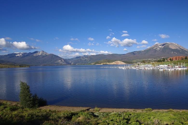
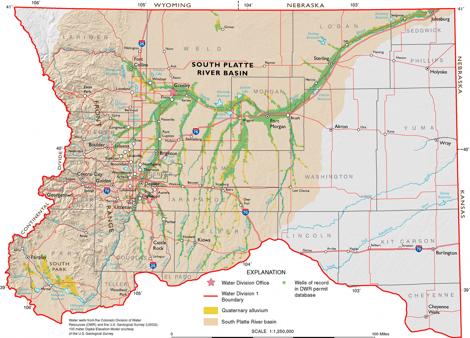
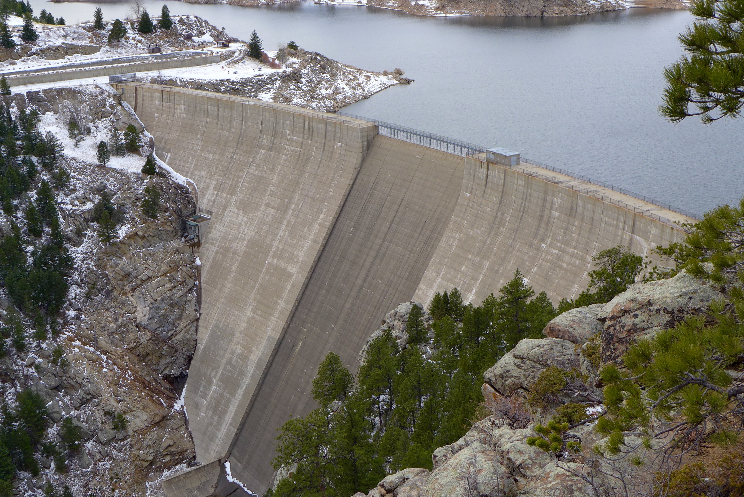
Dillon Reservoir in Summit County is the largest reservoir in the Denver Water system, holding more than 257,000 acre-feet of water when it’s full. With two outlets — the Blue River and Roberts Tunnel — Denver Water officials say it’s complicated to operate. Photo credit: Denver Water via Aspen Journalism
Denver Water officials increased the release of water from Dillon Reservoir into the Blue River to about 400 cubic feet per second in the first week of May as inflow held steady at about 500 cfs through Monday, May 11. The latter number is expected to steadily rise as spring runoff picks up.
The current forecast from the National Oceanic and Atmospheric Administration’s Colorado River Basin Forecast Center estimates as of May 11 that there is 146,000 acre-feet of water — in the form of snowmelt — that will flow into Dillon Reservoir through July 31. There’s currently 17,500 acre-feet of space in the reservoir, according to Denver Water, so about 128,500 acre-feet will flow out of the reservoir either to the Blue River or Roberts Tunnel by July 31, with an estimated 13,000 acre-feet through the tunnel.
All of these complex calculations are the first steps in a delicate dance Denver Water performs each spring to balance public safety with Denver’s water needs, recreation, hydroelectric demands and obligations to downstream senior water-rights holders.
“Dillon is our biggest reservoir and one of our more complicated to operate,” said Nathan Elder, water resources manager for Denver Water. “Most of our other reservoirs only have one outlet, but Dillon’s got both the outlet to the Blue and the outlet to the Roberts Tunnel, which provides water to the East Slope and down the North Fork (of the South Platte River) to Strontia Springs Reservoir and then to our customers.”
The Roberts Tunnel, finished in 1962 about the same time the old town of Dillon was relocated to its current spot and the Dillon Dam was built, is a 23-mile concrete conduit that diverts water from the Blue River basin on the Western Slope to the South Platte Basin on the Front Range to supply more than 1.4 million Denver Water customers.
Colorado transmountain diversions via the State Engineer’s office
This system is what’s known as a transmountain diversion — one of many that bring water from the Colorado River basin on the west side of the Continental Divide to the state’s population center on the Front Range. What it’s not, Elder said, is a way to avoid dangerous spring-runoff flooding.
“We can’t use Roberts Tunnel as a flood-control option,” he said. “So we’re very careful about the amount of water we take from the West Slope over to the East Slope. And when we use the Roberts Tunnel, we can only take it over to the East Slope if it’s put towards the demand. We can’t just dump it over there to prevent flooding or high flows below Dillon.”
The 2014 Colorado River Cooperative Agreement places a 400,000 acre-foot limit on Blue River water stored in existing or future Denver Water storage facilities on the Front Range.
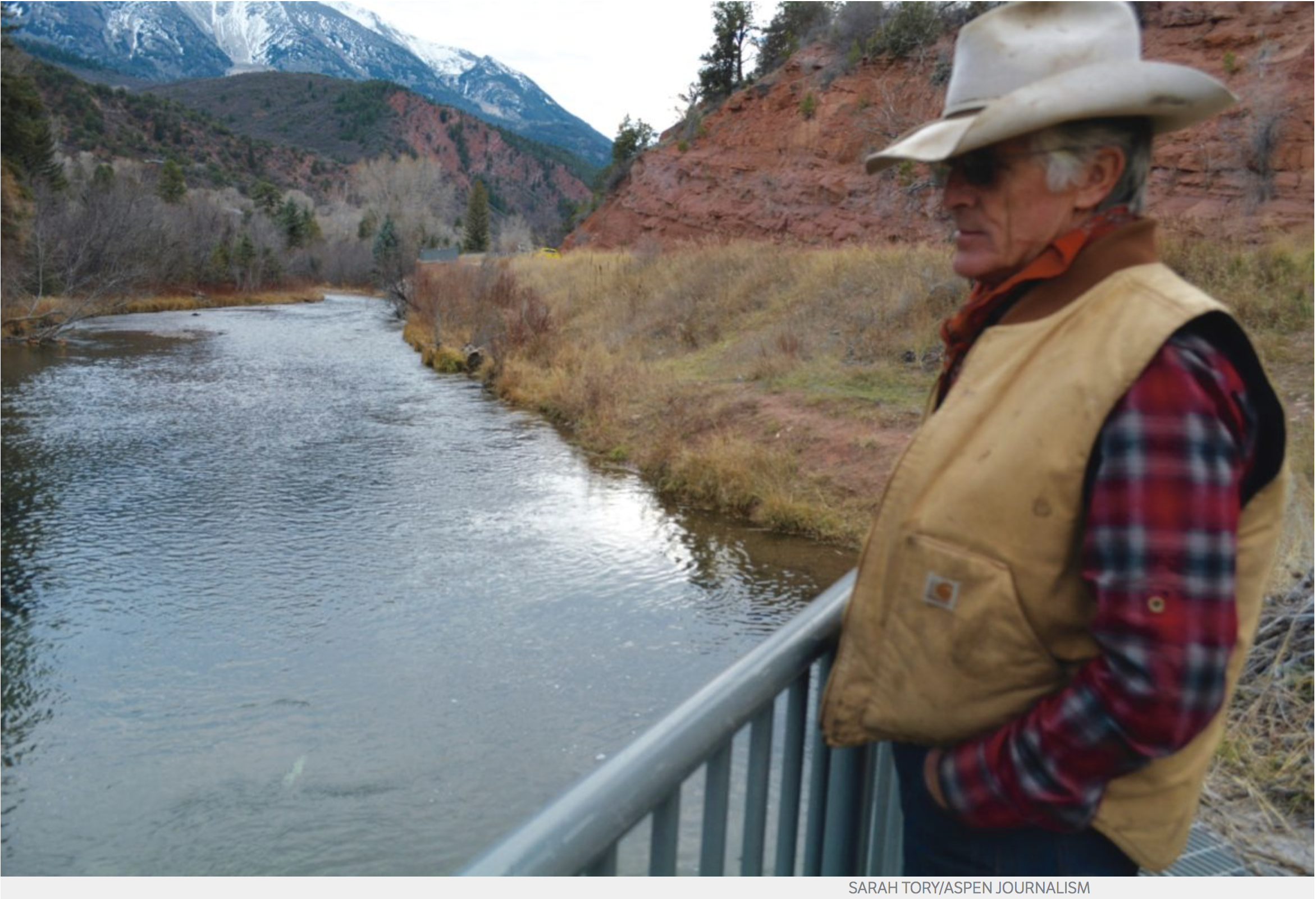
There are more than 1,000 properties in regulatory floodplains in Summit County, according to the Federal Emergency Management Agency, and quite a few of them are along the Blue as it makes its way northwest through Silverthorne and toward its confluence with the Colorado River near Kremmling.
The Blue River travels north-northwest through Dillon Reservoir to its confluence with the Colorado River near Kremmling. Each spring Denver Water performs a delicate balancing act to accommodate flows from snowpack runoff. Photo credit: Denver Water via Aspen Journalism
Snowpack melting
This time of year, as snowpack begins to melt into local tributaries — the Blue, Snake River and Tenmile Creek all feed Dillon Reservoir from the south — Elder and his team closely monitor snowmelt forecasts and weather reports to coordinate with local officials to prevent flooding.
“Denver Water has worked with the town over the years to release water from Dillon Reservoir at rates between 50 cfs and 1,800 cfs,” said Tom Daugherty, Silverthorne’s director of public works. “They have done a very good job of doing that. Denver Water attends our local meetings concerning snowmelt runoff and inform us of what they expect.”
FEMA designates 2,500 cfs as a 10-year flood level just below Dillon Dam, while 3,350 cfs there would be a 100-year flood level. The amount of runoff pouring into the reservoir varies widely, depending on weather conditions and snowpack, from a low inflow of 410 cfs in the drought year of 2012 to a high of 3,408 cfs in 1995.
The amount of snowpack on the Front Range and rate of melting due to high temperatures or rain events also impacts when Denver Water turns on the Roberts Tunnel and how much water it takes out of Dillon Reservoir. The Blue River Decree dictates that Denver Water needs to keep as much water on the Western Slope as possible and can take water only to meet demand.
“Last year was a good example of that,” Denver Water spokesman Todd Hartman said. “We had so much snowpack on the Front Range that we just didn’t need the Roberts Tunnel water and couldn’t take it because of that demand issue.”
That resulted in higher flows on the Blue below the dam last runoff season.
“It got up to around 1,900 cfs, and we didn’t actually turn on the Roberts Tunnel until the second week in August last year,” Elder said. “That’s after everything on the East Slope filled, and we started dipping into that storage and streamflow dropped off on the East Slope.”
This year, there’s a similarly healthy snowpack above the reservoir and also decent snowpack on the Front Range, but temperatures have been higher and the spring runoff season hasn’t been nearly as wet and cool as last year.
“We have a Snotel (snow telemetry) site on top of Hoosier Pass, which is extremely important for monitoring that basin and for forecasting, and it’s still at 121% of normal right now,” Natural Resources Conservation Service hydrologist Karl Wetlaufer said in early May. “It looks like it did actually have a net accumulation through April and is just really just starting to turn around and melt out now over the last few days with this warm weather.”
The Natural Resources Conservation Service produces snowmelt forecasts used by Denver Water, which also taps into the National Oceanic and Atmospheric Administration forecast center.
Based on information from Snotel sites, snowpack above Dillon Reservoir peaked at 127% of normal. The forecast center’s inflow outlook for Dillon Reservoir is 104% of average, and the forecast from the Natural Resources Conservation Service was 107% of average.
The first priority for Denver Water is to fill the reservoir to meet customer needs, but it also tries to minimize high flows out of the reservoir via the Blue River and maintain water levels so that the Frisco and Dillon marinas can operate from June through Labor Day. Elder said the minimum operating level for both Dillon and Frisco marinas is 9,012 feet in elevation.
The goal, Elder said, is to get the reservoir to that level or higher by June 12. On May 11, the surface level of the water in the reservoir was at 9,010 feet. The reservoir is full when the elevation of the water, as measured on the dam, is 9,017 feet, which is 257,304 acre-feet of water. At 9,010 feet, the reservoir is holding about 236,232 acre-feet of water.
Release too much and too early — to avoid high flows and flooding downstream — and Denver Water runs the risk of missing the chance to fill Dillon for use by its customers later in the summer season as well as keep the reservoir full for a long boating season. And then there are the downstream hydroelectric factors and calls by senior water-rights holders.
An inspection team leaving the 23-mile Roberts Tunnel east portal in Park County in 2016. The tunnel, which diverts water from the Blue River to the Front Range is inspected every five years. Photo credit: Denver Water via Aspen Journalism
Senior water rights
While the Blue River Decree does not have a volumetric limit on how much water Denver Water can take out of Dillon Reservoir through the Roberts Tunnel to meet its customer needs, the Roberts Tunnel right is from 1946 and is junior to Green Mountain Reservoir and Shoshone Power Plant rights, which limit the ability of Denver Water to divert. The Roberts Tunnel right is for 788 cfs, which is not a storage right but instead a direct-flow right.
So if Green Mountain gets toward the end of its fill season and hasn’t filled and Dillon has diverted, then Denver Water owes water to Green Mountain. Green Mountain Reservoir, located on the Blue River in northern Summit County, was created specifically to compensate the Western Slope for diversions to the Front Range as part of the Colorado-Big Thompson Project.
Then on the Colorado River in Glenwood Canyon, well downstream from where the Blue feeds the Colorado at Kremmling, there’s Xcel Energy’s Shoshone Generating Station hydroelectric plant — which has one of the most senior water rights on the main stem of the Colorado River. A 1902 right draws 1,250 cfs of water downstream to meet the plant’s needs. During dry times of the year, such as late summer, the power plant often places a “call” on the river, meaning junior diverters upstream — including Denver Water — must stop diverting so that Shoshone can get its full allocation of water.
Elder said Denver Water wants to fill Dillon Reservoir quickly enough each spring before any potential Shoshone call. If a call came before Dillon was full, Denver Water would have to release water from Williams Fork Reservoir in order to keep water in Dillon Reservoir. However, Williams Fork can hold only 96,000 acre-feet of water.
“We want (both reservoirs) to fill quick enough that we fill both before that Shoshone power plant call comes on and before the senior call comes on the river, but not too quick that we fill before peak runoff where we get in those high-flow situations,” Elder said. “So it’s a real balancing act there. You’re balancing elevations for marinas, downstream water rights, filling the reservoir safely and then also any potential releases you may need to make from Roberts Tunnel.”
Aspen Journalism, a 501(c)(3) nonprofit organization supported by its donors and funders, covers water and rivers in collaboration with the Summit Daily News and other Swift Communications newspapers. This story ran in the May 17 edition of the Summit Daily.
The Colorado Supreme Court on Monday upheld an agreement that would allow a water conservation subdistrict in Southern Colorado to import water to the Rio Grande and use the entirety of its own imported water under long-standing legal doctrine.
The Closed Basin is a watershed in the San Luis Valley with a physical separation between itself and the Rio Grande. Surface water, therefore, does not flow into the river, and is imported through canals. However, a study revealed that pumping from an underground aquifer in the Closed Basin was causing depletion to the waters of the Rio Grande.
In 2010, a water court judge approved a plan for the Special Improvement District No. 1 of the Rio Grande Water Conservation District that proposed a way to restore river flows otherwise lost to irrigation-related pumping. The subdistrict would have to replace the river depletions, and consequently it contracted with Santa Maria Reservoir Company to lease water from its supply in two reservoirs.
The company, however, had to amend its bylaws to allow for the water to go toward replacement of flows, not just for irrigation. The idea was to release water from a reservoir and have it flow down the Rio Grande, with no diversions for irrigation to the Closed Basin.
By April 2016, all affected parties had withdrawn objections except for one rancher, Jim Warner. He owned property in the Closed Basin and needed the subsurface water created as a byproduct of the importation to stay at a certain level. Warner opposed the change out of a suspicion that he could no longer use flood irrigation of his hay crops.
During the trial, SMRC argued that its importation scheme would not harm other water users in the Closed Basin. Warner did not provide any evidence to support his claim, as well as for his allegation that the Closed Basin and the Rio Grande were not separate water systems after all.
The water court found acceptable the arrangement for SMRC to replenish the Rio Grande and for the subdistrict to use the entirety of its imported water into the Closed Basin for its own irrigation purposes…
Writing for the Supreme Court, Justice Carlos A. Samour Jr. found that the water court was correct to approve the Closed Basin arrangement based on cases as early as 1907.
“We have repeatedly said that when water is introduced into a stream system from an unconnected stream system, it is imported,” he wrote. There was plainly a divide between the Closed Basin and the river, and the SMRC’s actions would not cause Warner injury.
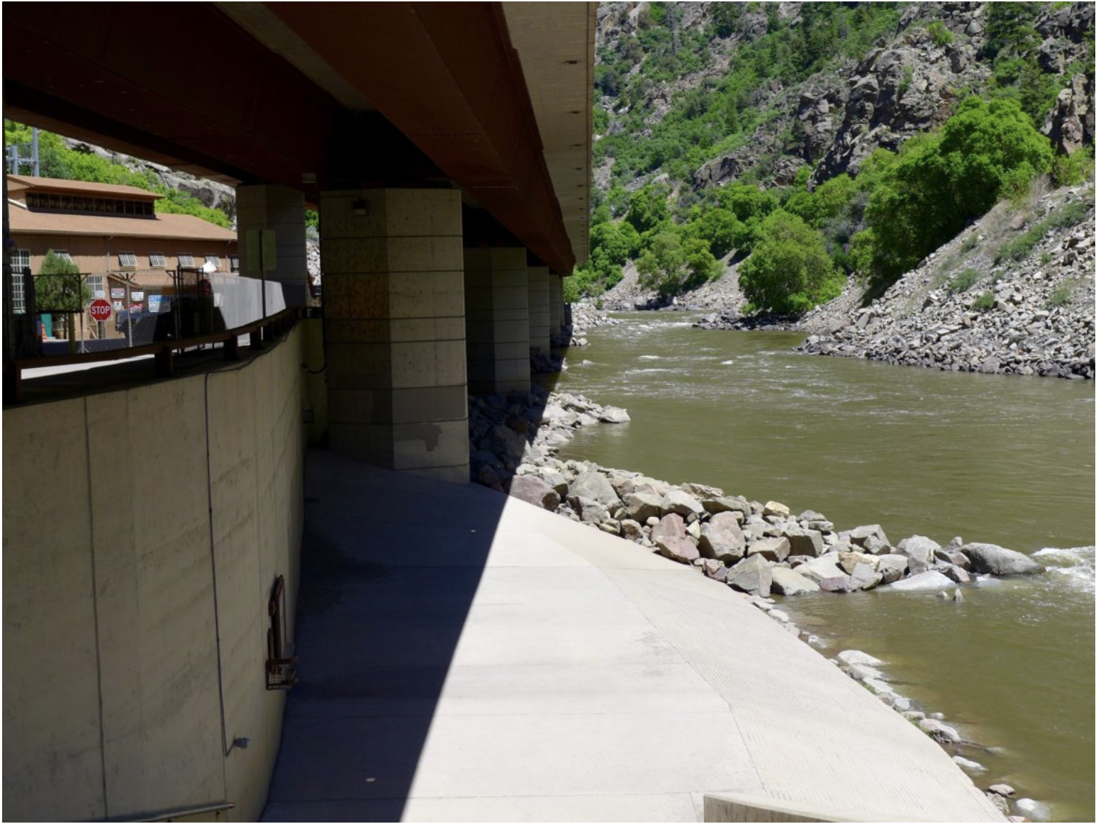
The penstocks and main building at the Shoshone hydropower plant, which uses water diverted from the Colorado River to produce electricity. The Shoshone Outage Protocol keeps water flowing down the Colorado River when the hydro plant is inoperable. Photo credit: Brent Gardner-Smith/Aspen Journalism
The Shoshone hydropower plant in Glenwood Canyon has been down since at least Feb. 14 and could be down until June, but a 2016 safety-net agreement has kept water flowing down the Colorado River.
The Shoshone Generating Station, owned by Xcel Energy, is the keeper of one of the largest water rights on the main stem of the Colorado River. In February, ice jams on the spillway caused water to flood the plant and damaged equipment inside, according to Xcel media-relations representative Michelle Aguayo.
Xcel said the COVID-19 crisis is complicating repair plans.
“Given the current circumstances, it’s more challenging to get contractors to repair equipment, but even so, we expect to be back in June,” Aguayo said in a prepared statement.
Xcel said service to electric customers will not be impacted by the outage.
The inoperable plant would be a major concern to water users on the Western Slope, except for the 2016 Shoshone Outage Protocol, which mimics conditions as if the plant were still operating and using its full amount of water.
When the plant is operating, a senior water right from 1902 draws 1,250 cubic feet per second of water downstream to meet the plant’s needs. That means that upstream junior water-right holders must leave enough water in the river for Shoshone to receive its full amount. It also means that the 1,250 cfs is available for other downstream users on the Western Slope.
The water used by the Shoshone plant is diverted at a low riverwide dam about two miles above the plant near the Hanging Lake exit on Interstate 70. The water is then sent through pipes along the cliffs to penstocks that send it down to the plant, where it spins turbines. All of the water is then released back into the river via a spillway at the top of what’s called the “Shoshone” section of the Colorado River, which is about five miles east of Glenwood Springs and is popular with kayakers and rafters.
This water is crucial for endangered fish in the often-dry, 15-mile reach near Grand Junction; for boaters and rafters near Glenwood; and for Grand Valley irrigators, who have begun filling their canals for the start of irrigation season, which began Wednesday.
In the past, if the hydropower plant was not operating, the water right tied to it is not being put to beneficial use and cannot be used. The 1,250 cfs could have been lost — either diverted to the Front Range or kept locked in reservoirs. But the Shoshone Outage Protocol took effect March 1 to keep water flowing in the river.
“We are very happy that the outage protocol exists,” said Andy Mueller, general manager of the Colorado River Water Conservation District. “It’s to make sure the water keeps flowing this way. It’s really about the fish as well as bringing the water to the Grand Valley.”
Formalized in 2016, the agreement is signed by many Colorado River water users, water providers and government agencies, including the U.S. Bureau of Reclamation, the Colorado Division of Water Resources, Denver Water, the River District and the Grand Valley Water Users Association.
Between Feb. 14 and March 1, flows were kept up by a winter maintenance outage agreement, according to Victor Lee, an engineer with the Bureau of Reclamation.
Lee said that about 1,400 acre-feet of water from Green Mountain Reservoir in Summit County has been released so far to meet the Shoshone Outage Protocol requirements. He said the protocol will probably be relaxed in the next week or two because spring runoff will begin to naturally boost river flows.
The Shoshone plant and its big water right have long been a concern for the River District, especially since outages have increased in recent years, including a penstock rupture in 2007. Since about 2018, River District officials have been in talks with Xcel about ways to preserve the Shoshone water right for the Western Slope.
“Those efforts are ongoing,” Mueller said. “We still view that as a significant priority for western Colorado.”
Aspen Journalism collaborates with The Aspen Times, the Glenwood Springs Post-Independent and other Swift Communications newspapers on coverage of water and rivers.
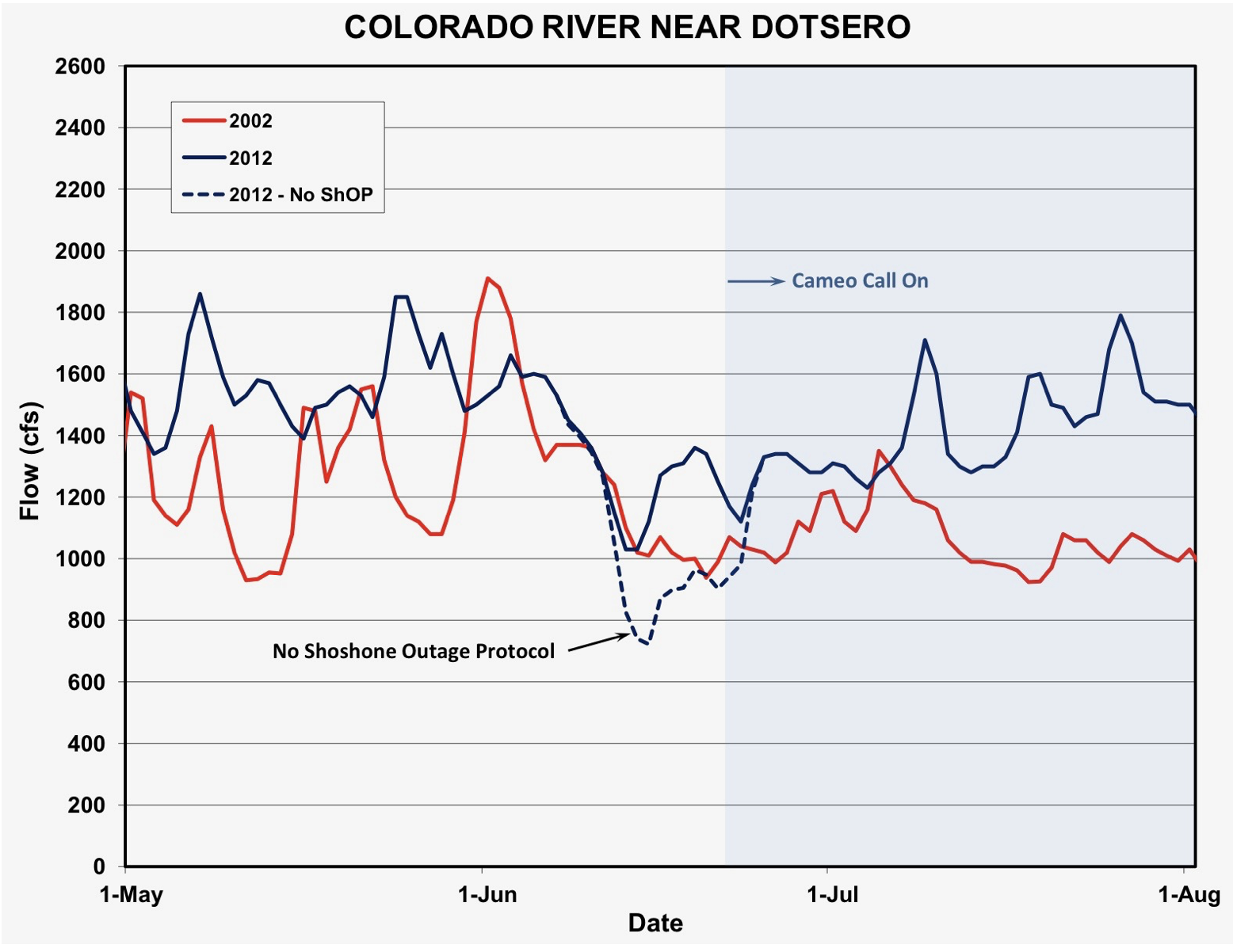
Number of days the Shoshone outage protocol, or ShOP, was in effect, and stages of the agreement.
FromThe Grand Junction Daily Sentinel (Dennis Webb):
A 2016 agreement is helping protect Colorado River flows downstream of Glenwood Canyon despite ice jams from the Colorado River shutting down the Shoshone Hydropower Plant in the canyon.
Jim Pokrandt, spokesman for the Colorado River District, a tax-funded agency serving counties within the river basin in western Colorado, said the problem at the plant occurred around March 1. Xcel Energy, the plant’s owner, says it won’t be using Colorado River water at the plant until it is repaired.
The plant’s operations are watched closely by the water community because it has one of the oldest water rights on the river in western Colorado — a 1902 right to 1,250 cubic feet of water per second.
That right has limited the ability of Front Range water users with more junior rights to divert Colorado River water. It helps keep water flowing down-river not just to the plant, but further downstream because the plant’s water use is nonconsumptive, benefiting municipal and agricultural water users, recreational river users and the environment.
However, the river district and regional water users have worried about the potential impacts on the river and water users whenever the aging plant is out of service and not calling for water under its senior right, such as when it requires maintenance.
To address that concern, reservoir operators including the river district, Denver Water and the U.S. Bureau of Reclamation agreed in 2016 to cooperate to maintain river flows at levels mimicking Shoshone’s normal operation, with certain exceptions.
Modified reservoir operations to mimic those flows are now in effect, and will remain so until snowmelt runoff causes the river flow to exceed the current outage protocol target of 1,250 cubic feet per second.
Pokrandt said that among the benefits of protecting flows, more water in the river means lower concentrations of total dissolved solids in the river due to dilution, reducing the need for water treatment by municipal water providers that rely on the river.
Kirsten Kurath, an attorney who represents the Grand Valley Water Users Association, a party to the 2016 agreement, said a big benefit of the Shoshone flows is maintaining flows in what’s known as the 15-mile reach of the Colorado River in Mesa County. Efforts to protect endangered fish in the river focus in part on maintaining adequate flows in that stretch of the river, upstream of the Gunnison River confluence…
While Grand Valley irrigators also have senior water rights on the river, Kurath said the Shoshone water smoothes out the river’s flows, making it easier for irrigators to plan and making water diversions more efficient than when flows are lower. “Everybody downstream always benefits as you keep water in the river,” she said.
The Orchard Mesa Irrigation District and Grand Valley Irrigation Co. are among other parties to the 2016 deal. As of late Monday afternoon, Xcel hasn’t yet said how long the power plant may be out of commission. According to the river district, Xcel has said that the COVID-19 outbreak is complicating repair plans…
The current outage agreement is in effect for 40 years. The river district says it and its West Slope partners are exploring ways to permanently protect the river flows.
Shoshone Hydroelectric Plant back in the days before I-70 via Aspen Journalism
Shoshone Falls hydroelectric generation station via USGenWeb
The penstocks feeding the Shoshone hydropower plant on the Colorado River in Glenwood Canyon. Photo credit: Brent Gardner-Smith/Aspen Journalism
The Shoshone plant and boat ramp on the Colorado River. Photo credit: Brent Gardner-Smith/Aspen Journalism
The blown-out penstock in 2007 at the Shoshone plant. Photo credit: Brent Gardner-Smith/Aspen Journalism
Shoshone hydroelectric generation plant Glenwood Canyon via the Colorado River District
Xcel truck at Shoshone plant. Photo credit: Brent Gardner-Smith/Aspen Journalism
Number of days the Shoshone outage protocol, or ShOP, was in effect, and stages of the agreement.
Large electricity generators use lots of water to cool their coal-fired plants. As those units shut down, expect to see battles heat up over how the massive amounts of water can be repurposed.
Any newfound source of water is a blessing in a state routinely stricken by drought and wildfire, where rural residents can be kept from washing a car or watering a garden in summer, and where farm fields dry up after cities buy their water rights.
State water planners long assumed that the amount of water needed to cool major power plants would increase with the booming population. Planners in 2010 predicted that, within 25 years, major power plants would be consuming 104,000 acre-feet per year of their own water. The Colorado Sun found that their annual consumption will end up closer to 10% of that figure.
The 94,000 acre-feet of water that major power plants won’t be consuming is enough to cover the needs of 1.25 million people, according to figures included in the Colorado Water Plan of 2015. (That’s counting water permanently consumed in cities, and not counting water consumed by agriculture and certain giant industries, or water returned to rivers through runoff and wastewater treatment plants.)
Already, water once used by now-defunct power plants is flowing to households, shops and factories in Denver, Colorado Springs, Boulder and Palisade, because the local water utilities owned the water and supplied the plants. When the plants closed, the cities just put their own water back into municipal supplies, officials in those cities said…
In Pueblo, Black Hills Energy shut down a 100-year-old, coal-then-gas-fired power plant downtown. After decommissioning stations 5 and 6 near the Arkansas River in 2012, Black Hills donated the water to public use. Water that once cooled the plant now flows in the Arkansas through the city’s Historic Riverwalk, where gondoliers paddle and picnickers gather in the sun for art and music. Renowned Denver historic preservationist Dana Crawford has partnered with a local developer on plans to revive the art deco power plant as an anchor for an expansion of the Riverwalk, with shops and restaurants.
In Cañon City, water that cooled the closed W.N. Clark power plant is going down the Arkansas River as well, Black Hills Energy spokeswoman Julie Rodriguez said. It is likely being picked up by the user with the next legal right in line.
The San Miguel River on the Western Slope is gaining some water from closure of the coal power plant in Nucla — at least temporarily until Tri-State Generation and Transmission Association, which owns the plant, finishes the tear down and reclamation, which requires some water. Spokesman Mark Stutz said Tri-State has made no decision on what to do with the water rights after that, but “we will listen to the input of interested stakeholders.”
Major power plants’ water consumption peaked in 2012 at about 60,000 to 70,000 acre-feet. It has dropped to about 47,000 acre-feet now and will fall further to about 27,000 acre-feet over the next 15 years, just from closures already announced. By the time the last coal plant closes, major power plant water consumption will have plummeted to about 10,000 acre-feet…
In the past 10 years, 13 coal power plant units in Colorado have shut down. Another 10 will close by 2036 or much earlier. The remaining four units are under review by their owners.
The last gas power plant built in Colorado was in 2015, according to the U.S. Energy Information Administration. All new power generation in Colorado since then has been renewable…
In the past 10 years, 13 coal power plant units in Colorado have shut down. Another 10 will close by 2036 or much earlier. The remaining four units are under review by their owners.
The last gas power plant built in Colorado was in 2015, according to the U.S. Energy Information Administration. All new power generation in Colorado since then has been renewable.
Transmission towers near the Rawhide power plant near Fort Collins, Colo. Photo/Allen Best
Technology has driven down the cost of wind and solar, and they now can provide power at a lower price per kilowatt-hour than coal-fired power in Colorado. Even accounting for the need to store electricity, bids to provide renewable energy have come in lower than the cost of coal-fired power.
Closure dates have been accelerating. Utilities are running scenarios on how they could shut down the last four coal-burning units in Colorado not already set for closure. They are Xcel Energy’s Pawnee in Brush and Comanche 3 in Pueblo, Platte River Power Authority’s Rawhide 1 near Wellington, and Colorado Springs Utilities’ Ray D. Nixon unit 1 south of the city.
Emissions controls and customers’ climate concerns are also driving the change, utility officials said.
For example, Platte River Power Authority already expects to be 60% wind, solar and hydro by 2023, and its board said it wants to reach 100% by 2030, spokesman Steve Roalstad said. A public review process started March 4 to discuss how best to achieve that. Closing the coal plant at Rawhide and even the adjacent gas plants by 2030 are options, but not certain, he said.
Early closing dates set for other coal plants could move up. PacifiCorp, a partial owner of three coal power units in Craig and Hayden in northwest Colorado, is pushing its partners, Tri-State and Xcel, for faster shut-downs. It wants to move more quickly to cheaper renewables…
As more power plants close in coming years, much of the water no longer needed will be water owned by the power companies themselves. Many were reluctant to talk about their water rights in detail.
Water court records show Xcel owns water from wells all over the metro area, and draws from Clear Creek. Xcel also owns 5,000 to 10,000 acre-feet in the Colorado River. That water is diverted to northern Colorado through the Colorado-Big Thompson tunnel under the mountains.
Xcel did say it is holding onto its water rights for now. It has been cutting its water purchases from cities, switching to its own water as power plants close.
On a smaller scale, Tri-State is now switching its J.M. Shafer power plant in Fort Lupton from city well water to its own water rights, city administrator Chris Cross said.
Water court records show another example of what can happen to utility-owned water: Xcel wants to use some of its Clear Creek water rights at a hydroelectric plant above Georgetown that is being renovated to produce more megawatts.
Some water might become available for other uses as more Xcel coal plants close, spokeswoman Michelle Aguayo said…
Closure of the power plants could open up arguments over where that water should go instead, explained Erin Light, state water engineer for the northwestern district.
“Every water right is decreed for an amount, a use and a place of use,” Light said. With the power plant gone, utilities can try to sell their rights, but other water users may dispute that in court.
Xcel, for example, owns 35,000 acre-feet of conditional water rights in reservoirs in the Yampa Valley that have never been built, she said. But “conditional” means the company gets the water only if it is actually needed, she explained. So when the Hayden power plant closes in the 2030s, Xcel would have to go back to water court to change the use or sell the rights, she said.
“Those conditional water rights become a lot more speculative if they are not operating a power plant,” she said. “Arguably, they would lose their conditional rights.”
Legislators are sufficiently concerned about speculators making money on Colorado’s water shortage that in March they passed Senate Bill 48 asking water officials to give them suggestions on how to strengthen current law against it.
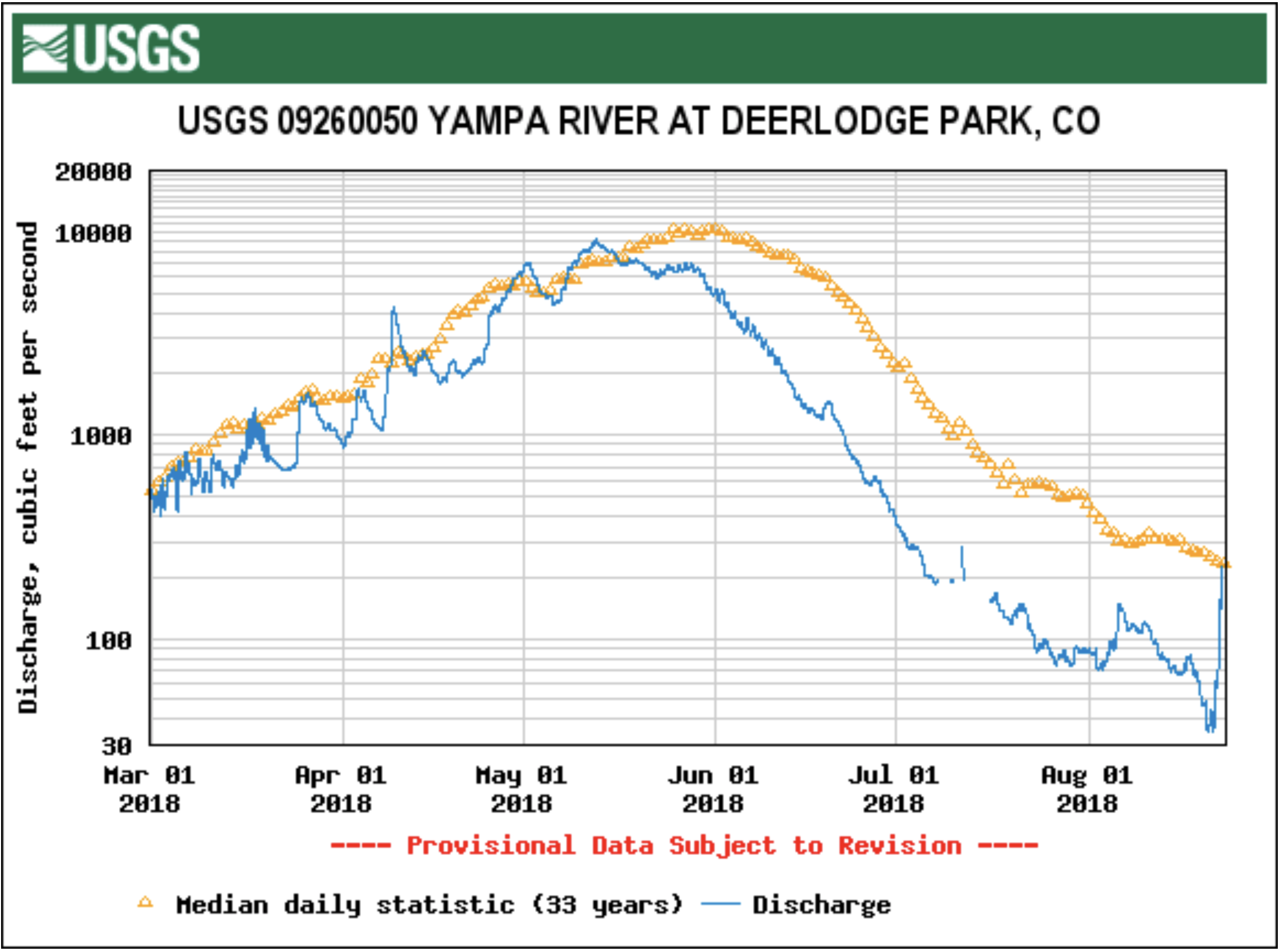
Steamboat Springs: Hundreds of ranchers in the scenic Yampa Valley have ignored a state request to begin measuring the water they use, putting them on a collision course with regulators that will land many of them in court this summer if they don’t relent.
Division Engineer Erin Light, the top water chief in the region, said roughly 70 percent of irrigators in this remote part of northwestern Colorado have not installed measuring devices, meaning that millions of gallons of water are being consumed without oversight, something that is routine on other river systems.
“I sent out a notice in March saying, ‘I’m going to issue an order if you don’t install them now,’” she said. “It was a friendly gesture.”
No one responded.
“We have not been impressed with the response,” Light said.
On Sept. 30, she issued a formal order to 550 ranchers, which, if ignored, could result in fines of up to $500 a day and court action.
Yampa River Basin via Wikimedia. Ranchers and farmers in the valley have largely ignored Division Engineer Erin Light’s order to install measuring devices as of December, 2019.
The deadline to respond this time was Nov. 30. Few did so, Light said.
Under the terms of the order, ranchers who don’t install measuring flumes or other devices to track diversion rates from the river into their irrigation systems will be cut off if they try to irrigate in the spring. They will also likely face prosecution, Light said.
“We’ll be working with the attorney general’s office to begin court proceedings,” she said.
The issue reflects an end to a gentleman’s agreement that dates back to the late 1800s, a consensus that said these tough, resourceful ranchers could manage their own water, that the state did not need to issue a direct order, and that the hay meadows, and cattle and sheep operations, could continue diverting their irrigation water as they always had.
And that’s largely because of the Yampa River’s amazing flows. Unlike almost any other place in Colorado and the West, water here was once so abundant that there was almost always plenty to go around. Measurements weren’t needed, and the state rarely had to step in to resolve disputes among water users, allowing Mother Nature free rein.
But chronic drought, climate change, and population demands have begun eroding the Yampa’s once bountiful supplies. For the first time ever, in the desperately dry summer of 2018, Light was forced to step in, cutting off some irrigators because more senior water rights holders weren’t getting their legal share of water. That sent a shock across the valley but triggered little action.
These days the Yampa River has the distinction of being the only one of Colorado’s eight major river basins that remains largely unmeasured and unregulated.
But Light said the issue has become too critical, and water too scarce, to allow that to continue.
Mike Camblin, whose family has been ranching here for more than 100 years, said he will comply with the order. But he and many of his colleagues feel the state has been too heavy handed in its approach.
“What I don’t like about the order is that it’s forcing people to install those or they are going to get fined $500 a day to run water even if it’s a free river,” he said. The term free river means that there is enough water in the stream to satisfy all water rights, and under normal circumstances people can divert as much of the excess as they want.
Not anymore.
“I’m very disappointed,” said Dave Seely, a long-time rancher who has 11 different irrigation ditches that span Moffat and Routt counties.
Many of his ditches already have measuring devices, but the order means he will have to install at least five new ones at a total cost of more than $10,000, he estimates.
Light is aware of the anger in the ranching community and said she understands the financial burden the order will place on many irrigators.
“I’ve been trying to encourage my water users to understand that there is a value to them in measuring how much water they divert. Water is often a rancher’s most valuable asset. But many don’t want to hear that,” she said.
Seely plans to comply with the order so that he can divert in the spring. But there is a lingering resentment and sense of loss for an era that is ending.
“Historically there was never a call on the river, but now there is,” Seely said. “Now we’re under the jurisdiction of the state engineer forever.”
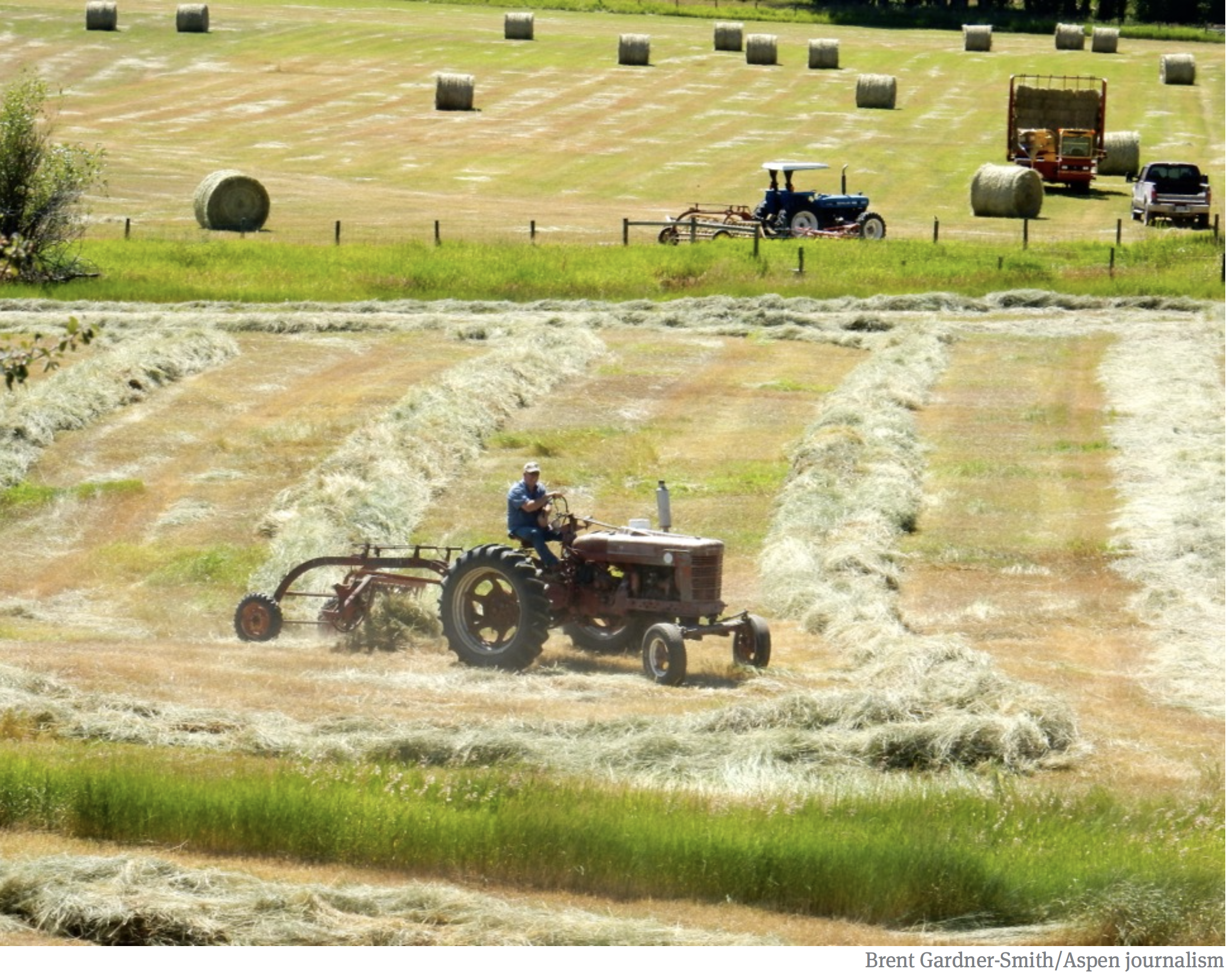
Hay fields in the upper Yampa River valley, northwest Colorado. Photo credit: Brent Gardner-Smith/Aspen Journalism
The Ella Ditch, in the Crystal River Valley, placed a call for the first time ever during the drought-stricken summer of 2018. That meant the Town of Carbondale had to borrow water from the East Mesa Ditch under an emergency water supply plan.
“This report sort of drove the message home that (climate change) is here and it’s no longer a conceptual discussion — it’s a pragmatic discussion,” Carbondale Mayor Dan Richardson said. “It was sobering from that perspective.”
According to the report, the average temperature since 2000 has been 2.2 degrees warmer than the 20th-century average. Water year 2018 was more than 4 degrees higher than the 20th-century average and was the warmest recorded in the past 120 years.
Warmer temperatures are bad news for the watershed because they have an overall drying effect, even if precipitation remains constant. According to the report, Roaring Fork River streamflows since 2000 have been about 13% lower than the 20th-century average, due, in part, to warmer temperatures. By 2050, a typical year in the Roaring Fork Valley is projected to be warmer than the hottest years of the 20th century, which means mild drought conditions even during years with average precipitation.
“Just the warming temperatures alone are enough to tell us drought will be a concern in the future and drought conditions are likely to persist for longer,” said WWA managing director Benét Duncan. “What does that mean for the water supply?”
The Town of Carbondale treats water at its facility on Nettle Creek, a tributary of the Crystal River. The town nearly had to shut the plant down during the summer of 2018 because of a senior call on the downstream Ella Ditch. Photo credit: Town of Carbondale
Drought illustrates vulnerability
The summer of 2018’s historic drought illustrated a vulnerability in Carbondale’s water supply that surprised local officials. Senior water-rights holder Ella Ditch, which serves agriculture lands south of Carbondale, placed a call for the first time Aug. 8.
This meant that because there wasn’t enough water in the Crystal for Ella Ditch to divert the amount to which it was legally entitled, junior water-rights holders, including Carbondale, had to reduce their water use — threatening the domestic water supply to roughly 40 homes on the Nettle Creek pipeline.
“We had a situation last summer where we were inches away from having to shut down our water-treatment plant at Nettle Creek because there was a more senior call on the river,” Richardson said. “When you look at the water rights we have on paper, most municipalities feel confident their water portfolio is resilient and can stand the test of time, but that was paper water. And when it comes to wet water, we were pretty vulnerable.”
Carbondale applied for and received an emergency substitute water-supply plan from the state engineer. The emergency plan allowed for a temporary change in water right — from agricultural use to municipal use — so that another irrigation ditch could provide water to the town.
The East Mesa Ditch Co., whose water right is senior to Ella Ditch’s, agreed to loan the town 1 cubic foot per second of water from Sept. 7 to Dec. 7 under the agreement. However, Carbondale had to borrow the water only until Sept. 28, when the call was lifted on Ella Ditch. East Mesa Ditch is located upstream from Ella Ditch. Both are used to irrigate lands farther downstream on the east side of the Crystal River.
The town didn’t pay East Mesa Ditch for the water but paid the company about $5,000 in legal and engineering fees to draw up the water loan agreement, according to Town Manager Jay Harrington.
A wake-up call
Although Carbondale has other sources it can turn to for municipal use, including wells on the Roaring Fork, the summer of 2018 and the VCAPS report were a wake-up call.
“Nettle Creek is a pretty senior right, and we didn’t anticipate it to be called like it was,” Harrington said.
Potential solutions to another Ella Creek call outlined in the report include moving away from Crystal water sources to Roaring Fork sources and providing upstream pumps to the homes on the Nettle Creek pipeline.
“I think (the report) gives one of the clearest pictures of where we are heading and what we need to look at as a municipality as the climate changes,” Harrington said.
Editor’s note: Aspen Journalism is collaborating with the Aspen Times and Glenwood Springs Post-Independent on coverage of water and rivers.
The Shoshone hydropower plant on the Colorado River east of Glenwood Springs was not producing power for most of last week [April 7, 2019], but regional water managers went with the flow and — thanks to an “outage protocol” — honored the plant’s senior water rights anyway.
Plant operators with Xcel Energy notified state, federal and regional water managers April 5 that they needed to inspect a leak in a diversion tunnel adit, or access point. To do so, they would be slowly shutting the flow of water to the plant’s two 7.5 mega-watt (MW) turbines and taking the plant offline.
The facility’s two-mile-long tunnel runs through cliffs in Glenwood Canyon and moves water from behind a dam on the river to the penstocks above the plant, which is just upstream of the boat ramp for the Shoshone run. The plant, which Xcel began powering down April 5, was offline by April 8.
The plant stayed offline until Friday, when the leak in the tunnel was fixed and the plant began powering back up, according to Michelle Aguayo, a media-relations representative at Xcel.
The outage at what Xcel calls the Shoshone Generating Station did not affect local or regional power customers, because other electricity on the grid system made up for the loss of the plant’s capacity, Aguayo said.
Outage lifts call
The Shoshone plant and boat ramp on the Colorado River. Photo credit: Brent Gardner-Smith/Aspen Journalism
In response to the plant going offline, officials at the state division engineer’s office lifted the call on the river on April 8. If the hydro plant is not in operation, the water right tied to it is not being put to beneficial use and cannot be administered, or legally enforced.
The call for water that is tied to the Shoshone plant’s most senior water right from 1902 means junior upstream diverters have to forego storing or diverting enough water to keep 1,250 cubic feet per second of water available for the plant.
Without the call, and the outage protocol, more water could be diverted under the Continental Divide or kept in upstream reservoirs, and less would flow through Glenwood Springs.
Ruptured penstock
The blown-out penstock in 2007 at the Shoshone plant. Photo credit: Brent Gardner-Smith/Aspen Journalism
The outage protocol concept was prompted by the increase in outages at the Shoshone plant starting in 2004. It took on greater importance when a penstock at the plant ruptured in 2007.
The protocol was given a trial run in 2010, formalized in 2012 as part of the Colorado River Cooperative Agreement, and then signed as a stand-alone agreement in 2016.
Parties to the protocol include the Colorado River Water Conservation District, the Bureau of Reclamation, Denver Water, Northern Water, Aurora and other entities.
Protocol days
Number of days the Shoshone outage protocol, or ShOP, was in effect, and stages of the agreement.
According to Don Meyer — who is a senior water-resources engineer at the Colorado River District, which is based in Glenwood Springs — the protocol was in effect from April 8 until the call came back on the river on Sunday.
And he said it worked as intended, with the parties cooperating in an amiable manner.
“Without the outage protocol, the river probably would have been impacted,” Meyer said.
He also didn’t think most upstream operators changed how they were managing their water, because the protocol meant they were still working against a need to keep flows on the river at 1,250 cfs, even with the plant offline.
Fortuitous flows
The river rose, on its own, during the time the plant was out. But the outage protocol also helped boost flows.
The river’s level was also helped by a short warm spell that caused flows at the Dotsero gage, where the flow to Shoshone is measured, to rise above 1,250 cfs starting the day that the plant first started powering down on April 8.
By April 10, the river had risen to 1,750 cfs. But then cold weather dropped the river back under 1,250 cfs on Sunday, as forecast, just when the plant was powering back up and the call was coming back on.
If the plant had been down longer, and flows had stayed low due to cool mountain weather, the outage protocol could have mattered more to the flows in the river.
Meyer said that when the plant was offline for repairs in 2012, the outage protocol kept the river through Glenwood from falling below 1,000 cfs for about two weeks in late June of that notably dry year.
Editor’s note: Aspen Journalism covers rivers in collaboration with The Aspen Times, the Glenwood Springs Post Independent, the Vail Daily, the Summit Daily and the Steamboat Pilot. The Post Independent and The Times published this story on April 16, 2019.
Headwaters of the Arkansas River basin. Photo: Brent Gardner-Smith/Aspen Journlaism
From the Upper Arkansas Water Conservancy District (Terry Scanga) via The Ark Valley Voice:
Most discussions involving water supply or quality require a good examination of historical perspective of water development. For this reason, understanding the system by which water is and has been allocated in Colorado since statehood, is a good starting point.
Water in Colorado is allocated as a private property right through a system referred to as the Appropriation Doctrine. It is the only arid Western state that utilizes a pure form of this doctrine called the “Colorado Doctrine”. This doctrine is enshrined in the state’s constitution. It is a constitutional right for the citizens of Colorado to an appropriation of water based on its beneficial use. Although many legislative statutes deal with water appropriation and use, these all rely upon, and must comport, with the basic constitutional right granted the citizens of the state.
This article is not intended to delve into the Appropriation Doctrine, except to point out that water rights and decrees are granted as a private property right. In fact, this system is automatically designed to apportion available water supply without undue interference from government, except for the administration of the existing water decrees or through the water court.
In 2005 legislation was passed creating the inter-basin compact committee and the nine basin roundtables. The basins utilized the Statewide Water Supply Initiative (a project to calculate the available water supply compared to demand –a needs assessment) to identify the projects and processes needed to address any water supply gap out to the year 2050; for all uses– municipal, industrial, irrigation (agricultural), environmental and recreational. Water entities and individuals were involved in each basin throughout the state to develop these plans.
Projects were identified and some were funded in part with grants from the state’s Colorado Water Conservation Board. The Colorado Water Plan was developed from these plans and processes. These projects have gone a long way to make available the necessary water supplies for the future. Many of the projects are ongoing and more will be needed to meet future needs.
Colorado is an arid state with future shortages forecast in the higher growth regions. In the Arkansas Basin, many junior water rights were established during high precipitation periods. Due to this, the Arkansas Basin today is considered an over-appropriated basin meaning that on average there are more decreed water rights than water available. Most of these junior water rights are decreed for irrigation use in agriculture. In the Arkansas Basin shortages are forecast for all water uses.
The Colorado Water Plan is a collection of the ideas and projects on how we can meet future water demands. Meeting the future need revolves around developing new Colorado River Supplies and Alternative Agricultural Transfers coupled with storage. The Colorado River normally has water that is unused and could be utilized to fill the gaps in the higher growth regions. Presently Colorado is well ahead in meeting its Compact obligations on the Colorado River, despite unsubstantiated claims from some state politicians and the administration that Colorado may be unable to meet its obligations.
Agricultural irrigation uses 80 percent or more of the available supply statewide. Some of these uses could be temporarily interrupted through court approved Lease-Fallowing agreements, and the water owner compensated, to meet shortages in drier years. In wet years existing storage and new storage could be utilized to save the excess for drier times. Storage projects, including alluvial storage, need to be built to meet the future needs. Water storage operations could be adapted to meet multiple uses for stream management, to meet increased demands for the environment and recreation.
Through the existing Appropriation System, the above plans and others are underway to meet this future need. All this can, and should, be completed through the Colorado Doctrine of Appropriation, a strong legal framework to guarantee the security, reliability and flexibility in the development and protection of water resources.
In terms of water supply, the greatest threat for the future would be a loss or erosion, through legislative or administrative action, of the time-tested Colorado Doctrine of prior appropriation. Actions are underway to use the water plan as a framework to advocate for the use of policy to appropriate water. Using policy for water appropriation would give the administration and legislature a pathway or initiative to utilize legislation, in lieu of the more deliberate Appropriation system that is designed to protect existing water rights from injury. This strongly suggests that the legislature and administration may attempt to act upon perceived crises to garner support to move future appropriations or changes of current water use through legislation instead of the water court system.
Already underway is a Demand Management Plan that will allow administrative policies to transfer water rights from agriculture through Deficit Irrigation, or by utilizing an undefined process termed “Conserved Consumptive Use”, to Lake Powell, or to municipal use. In the Arkansas Basin most irrigation is already in a deficit so there is no water to be saved. Under Colorado’s pure form of prior appropriation, in low flow periods, water rights are curtailed automatically to force reductions in use. There is no need to use state policy to create conservation.
The frightening part of these actions is that, if successful, the only way for water right owners to protect themselves from injury will be expensive court action. If legislation is successful in adopting the concept of “Conserved Consumptive Use” it is possible we will see lower flows in the Arkansas River due to a reduction in trans-mountain diversions. These diversions support all uses in the river, such as the voluntary flow management program. Instead of water flowing to the Arkansas River, some may flow down the Colorado River to Lake Powell for storage and eventual evaporation there, under a plan called Demand Management.
In the Upper Arkansas Basin water quality has been addressed is various ways. The Arkansas River was polluted by mining runoff and is normally affected by natural geologic formations. Most of this pollution has been cleaned-up, and today there are large sections of gold medal fishing. Studies conducted by the US Geologic Survey have concluded that most of our ground water is of good quality. These are good things.
But the threat to water quality from sediment runoff from burn areas in our forests are real. Due to the beetle infestations and decimation of the forest stands in the US Forest lands, fire is more likely and has occurred.
The after effects of fire is larger than normal storm runoff. This will, and has already caused, heavy sediment loading on our streams and the Arkansas River. The Upper Arkansas Water Conservancy District (UAWCD) and the Arkansas Basin Roundtable is working with the US Forest Service and local entities to address some of these areas. Locally, the UAWCD is working with the Forest Service on a pilot project to remove beetle killed forest stands and make it a commercially viable resource. If successful, this may be part of the solution.
In the lower part of the Upper Arkansas River Basin, in Eastern Fremont County, there is a geologic formation that contains selenium that contributes to contamination in this part of the Arkansas River. At this time simply identifying these areas is a challenge, but it is being worked on by the US Geologic Survey. Most of this type of contamination primarily affects the Lower Arkansas Basin. Delivery of good municipal drinking water supplies is being undertaken by the South Eastern Colorado Water Conservancy District, with the construction of a pipeline from Pueblo Reservoir to the Lower Basin communities.
Scott Hummer shows off a fish passage at a North Poudre Irrigation Company diversion structure. His agency worked with Fort Collins Natural Areas and Colorado Parks and Wildlife to include a fish passage when the irrigation company replaced a diversion structure on the Poudre River that was destroyed by the 2013 floods. Work was completed [in February 2016]. (Pamela Johnson / Loveland Reporter-Herald)
Scott Hummer was kind enough to forward the materials below in celebration of the 140th anniversary of the creation of Colorado’s water commissioners:
John,
This past Tuesday, February 19, 2019 marked the 140th anniversary of the creation of the position of Water Commissioner by the State Legislature/General Assembly on February 19, 1879…
The concept of Colorado’s system of Prior Appropriation, “the Colorado Doctrine”, was first established in the “gold camps” of the late 1850’s. The concept was first put into practice in the “gold camps” of California and came to Colorado with the “miner’s courts” established by the original “prospectors” in the territory.
And yes, the Water Commissioner position came before the creation of the State Engineers Office as well as the position of “Superintendent of Irrigation”, today’s Division Engineers.
In brief the original legislation created the position as well as the first ten water districts, and as many know…the legislation was in response to the “water war” along the Poudre River in the mid 1870’s…
In 2004, a “celebration” of the 125th anniversary was organized and Water Commissioner were recognized on the floor of the Colorado House of Representatives at the Capital and received an honorary proclamation from then Gov. Owens…
Also in July of 2004, water commissioners were invited to attend and participate in the annual Water Workshop, at then Western State College in Gunnison.
The title of the ‘o4 Water Workshop was “Technology, Science (including the Dismal Science, and Changing Politics of Water”.
So after 15 years, perhaps, it is appropriate to inform and educate the water users and citizens of Colorado as to the public servants that serve them so well.
“He who expects the letter of the law in relation to irrigation to be executed with the precision of clockwork, and that infallible results will be obtained, has a small conception of the tangled web of difficulties in the way, and a meager knowledge of the uncertainties of the element to be manipulated.” — J.P. Maxwell, State Engineer 1890
Proposed water legislation that might have upended Arizona’s Colorado River drought plan was set aside by a leading Republican lawmaker following a day of tense debate.
The dispute over the bill pitted House Speaker Rusty Bowers, who introduced the measure on behalf of a group of farmers and ranchers, against the Gila River Indian Community, whose leader threatened to pull out of the drought deal if the bill went forward.
Bowers’ decision to yank the bill from consideration on Tuesday appears to clear the path for Arizona to take a series of steps to finish its piece of the Drought Contingency Plan, which involves taking less water out of Lake Mead to prevent the reservoir from falling to critically low levels.
But even with what had seemed a difficult snag now somewhat smoothed over, Arizona still needs to finish a list of about a dozen water agreements to make its piece of the Colorado River deal work. And Arizona’s top water managers said they expect completing those deals will take longer than a March 4 deadline set by the federal government.
If Arizona and California miss that deadline and don’t sign the Drought Contingency Plan, the seven Western states that rely on the Colorado River face an uncertain process. Federal officials have said they plan to ask the seven governors for input on steps that should be taken to prevent the levels of Lake Mead from continuing to fall. It’s not clear how that process would end, or whether it would spark more disagreements.
On Tuesday afternoon, though, one big potential obstacle appeared to be out of the way after Bowers announced at a House committee hearing that he was pulling House Bill 2476.
The legislation would have repealed the state’s water-rights forfeiture law, a measure often called “use it or lose it,” under which water rights may be forfeited if water hasn’t been used for more than five years. The bill would have changed the law so that not using a water right wouldn’t result in automatic forfeiture.
The legislation was aimed at addressing the concerns of farmers and ranchers in the Upper Gila Valley in southwestern Arizona, where the Gila River Indian Community has filed forfeiture cases against some landowners.
Bowers said in a statement that he will not move forward with the bill but will “continue to fight” for landowners in the Upper Gila Valley. He said because the bill “has nothing to do with the Drought Contingency Plan, I refused to include it in those discussions.”
Bowers said he didn’t want to give the Gila River Indian Community “veto power” over water legislation, but that he also didn’t want to interfere with ongoing litigation that may affect well owners along tributaries of the Gila River. He said those factors, as well as the deadlines the state is facing, led him to hold the bill.
Bowers said he still thinks the bill focused on an important issue that has yet to be resolved.
“The concept of forfeiture of water rights is a terrible possibility for these thousands of rural folks across Arizona,” Bowers said in a statement. “And it deserves the attention of the Arizona Supreme Court in seeking a just and reliable remedy.”
FromThe Associated Press (Jonathan J. Cooper) via The Denver Post:
It’s the latest hurdle threatening the plan between seven states to take less water from the drought-starved Colorado River, which supplies 40 million people and 5.5 million acres of farmland. Missing the March 4 deadline could allow the federal government to step in and decide the rules.
About half of the 15 agreements that Arizona needs to secure among water users will be ready by March 4, said Ted Cooke, director of the Central Arizona Project, which brings Colorado River water to the sprawling cities and farm fields around Phoenix and Tucson.
“That’s an artificial deadline, and these are very complex agreements and very complex negotiations, and we will take the time that we need to do them properly,” Cooke told reporters Tuesday following a meeting of water users working on the drought plan.
He said he hopes to finalize all the agreements within 60 days…
Arizona lawmakers have approved the drought plan, but U.S. Bureau of Reclamation Director Brenda Burman has said the state also must finalize the complex agreements needed to implement it.
If that’s not done by March 4, Burman says she will ask governors what should happen next — starting a process that could result in federally mandated cuts instead of the voluntary plans negotiated by the states. That’s particularly worrisome in Arizona, which has the lowest-priority water rights on the Colorado River.
Cooke repeatedly declined to speculate on what would happen if the state doesn’t finish its work by the deadline. But he said Arizona would probably be done before the federal government could get very far down an alternative path.
A fleet of rafts makes its way down the Green River toward its confluence with the Yampa River. Future potential releases of water out of Flaming Gorge Reservoir to boost levels in Lake Powell shape the flows on the Green River, although it’s not clear how the releases may change flow levels. Photo credit: Aspen Journalism/Brent Gardner-Smity
After 19 years of extended drought in the Colorado River basin, water users in Northwest Colorado are concerned that the region could become a “sacrificial lamb” as the state seeks to reduce water use to meet downstream demands.
As Colorado water officials begin work on a new “demand management” system to reduce water consumption, members of the Yampa-White-Green Basin Roundtable, which met Jan. 9 in Craig, are seeking to make sure the cutbacks don’t disproportionately impact their river basins, including the Yampa, White and Green rivers. The concerns prompted the creation of a new Big River Committee, which met for the first time Jan. 9, to advocate for the basin on state and regional issues across the Colorado River system.
“We’re already doing our fair share,” said Routt County Commissioner Doug Monger, a basin roundtable member and fourth-generation cattle rancher. “[In the Yampa basin] we already use only 10 percent of our water — 90 percent of our water goes to Lake Powell.”
There is relatively little reservoir storage on the Yampa River — less than 72,000 acre feet of water on the main stem and a total of 113,000 acre feet in the basin — compared to other major rivers in the West, meaning most of the water feeds into the Colorado River system and eventually Lake Powell.
“Such a small part of our native flow is developed, and there are concerns about how much should fall on the shoulders of our basin to send past the state line when we already don’t use very much,” said Yampa White Green Basin Roundtable Chair Jackie Brown, who is the natural resources policy advisor for Tri-State Generation and Transmission.
Indeed, data shows that consumptive water use in the Yampa basin averaged about 182,000 acre feet of water annually between 1990 and 2013, or about 10 percent of the basin’s total 1.74-million acre feet of average annual stream flow, according to hydrologic models used by the state.
By comparison, upper Colorado River stream flows averaged about 3.8 million acre feet of water over the same time period, not including the Gunnison River. Consumptive use equaled about 908,000 acre feet, or about 24 percent of the basin’s total water, according to the same data source.
But Colorado water law doesn’t account for such discrepancies across basins, and prioritizes water use according to a system based on dates tied to the initiation of a water right, often described as “first in time, first in right.”
“The Yampa and the White both were settled at such a later time period than the Front Range and some other areas, and we’re that much further behind in priority dates,” Monger said. “If we want to go forward on the prior appropriation system for allocating future water — last one in is the first one cut — that absolutely doesn’t work for us.”
Yampa River
Demand management
Many roundtable members believe the Yampa and White river basins should have the right to develop their water resources further in the future.
“We’re the sacrificial lamb if they were to lock things in the way they are now,” said Kevin McBride, general manager of the Upper Yampa Water Conservancy District and a member of the Big River Committee.
However, such worries are largely speculative at the moment, as the mechanisms of a demand management program are far from decided and drought contingency planning hasn’t yet been finalized.
“This is the very, very beginning of the demand management conversation,” said Brent Newman, the interstate, federal and water information section chief for the Colorado Water Conservation Board.
The board has already committed to avoiding “disproportionate negative economic or environmental impacts to any single sub-basin or region within Colorado while protecting the legal rights of water holders,” according to a policy statement adopted by the agency’s board in November.
“We want to make sure no basin is a target basin, and as best we can, make sure reductions are shared equitably across the state, across basins and the divide,” Newman said. “We’re trying to make things fair.”
If a compact call were to occur — a demand by lower basin states for more water to be sent downstream according to the Colorado River Compact — then it is widely expected that Colorado water officials will use the prior appropriation doctrine to curtail water use based on seniority.
“We want to be proactive and avoid a compact call instead of being reactive and responding to crisis if it came to pass,” Newman said.
“Big river” issues aside, Northwest Colorado water users are feeling the squeeze after record-breaking heat and drought in 2018 prompted the first-ever call on the Yampa River.
Furthermore, officials at the Colorado Division of Water Resources will examine this year whether the Yampa and the White rivers should be designated as “over-appropriated,” Division Engineer Erin Light told roundtable members at the Jan. 9 meeting.
The designation would signal that there is not enough water to meet demands during dry years, and new water rights would be conditional to available water supply.
But even as water users start to adjust to the new local reality, roundtable members are preparing for an uphill battle to argue their case regarding demand management.
“We’re already sending as much water as we can,” Monger said. “We’re paying the bill for Colorado.”
Editor’s note: Aspen Journalism is collaborating with the Steamboat Pilot & Today, the Craig Press and other Swift Communications newspapers on coverage of rivers and water. The Pilot published this story online on Thursday, Jan. 31, 2019 and the Press published it online on Jan. 30, 2019.
FromThe Grand Junction Daily Sentinel (Erin McIntyre):
Three Mesa Creek Ditch water users, Andrea Clark, Tom Kirkpatrick and Dana Black, objected to the resort’s plans to divert the water during the wintertime, transporting it to a nearby reservoir and storing it for snowmaking and other uses…
In that trial, the ditch users argued the ski resort bought a 1- cubic-foot-per-second water right that didn’t totally belong to the seller. They also accused Powderhorn of buying the water on speculation, as it had no way to transport or store the water in question when it asked the state for permission to change the way the water was being used.
George Bevan, a former Mesa Creek Ditch Co. president who died in October, sold the water to the ski resort about three years ago. Powderhorn intended to divert up to 150 acre-feet of the water during the winter, transporting it more than a mile away across private property to the H.U. Robbins Reservoir or a small pond at the base of the resort, and use the water for snowmaking.
The ski resort planned on purchasing, leasing or condemning rights of way necessary to transport the water, according to previous court documents. Powderhorn has 42 snowmaking acres and wanted to expand its operations.
But Boyd ruled the most water that Bevan could have used, historically, for watering his livestock from Oct. 1 to April 1 each year is only 6 or 7 acre-feet, at most.
While he decreed that Bevan owned the right to use 1 cubic foot per second of the water Powderhorn purchased from him, he ruled the water right had been used at much lower levels than the ski resort argued.
Bevan testified he kept a maximum of 400 cows at the location over the winter, using the water right for livestock.
A water engineer testified that amount of cattle would consume as much as 7 acre-feet of water over the course of a winter, and the judge used that amount to determine the historic use of the water right. An acre-foot is equal to 325,851 gallons, enough water to cover a football field a foot deep…
The issue of who owns exactly how much winter water in this section of the Mesa Creek Ditch remains unresolved, but the judge ruled that Powderhorn has the right to use the historical amount of water Bevan used and sold to the resort.
The judge also ruled the ski resort is one of only nine original claimants of the winter water right on the ditch, meaning other users who believed they had the right to use the water over time may be doing so illegally.
It’s unclear whether Powderhorn will opt to apply to use the lesser amount of water for snowmaking or pursue its plans to transport the water from Mesa Creek to the ski area. The judge denied the ski resort’s application in this instance but did not prevent it from reapplying in a future application.
The judge’s ruling leaves the ski resort with the option of reapplying to use 7 acre-feet of water over the course of a winter for snowmaking, one-fifth the amount Powderhorn wanted to use.
Click here to read the report. Here’s the release from the Bureau of Reclamation (Patti Aaron):
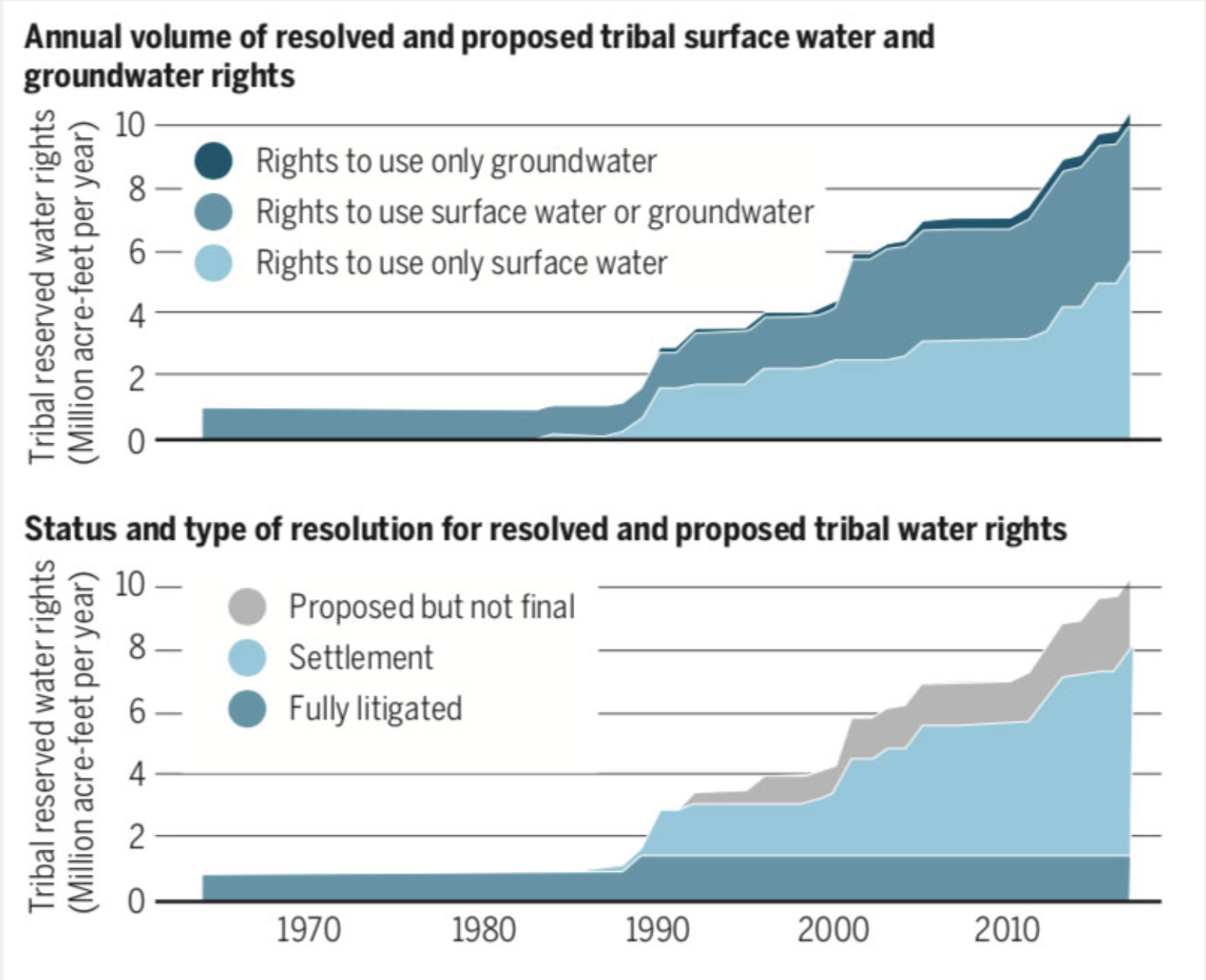
Bureau of Reclamation Commissioner Brenda Burman announced today the release of the Colorado River Basin Ten Tribes Partnership Tribal Water Study that was conducted collaboratively with the member tribes of the Ten Tribes Partnership.
The study documents how Partnership Tribes currently use their water, projects how future water development could occur and describes the potential effects of future tribal water development on the Colorado River System. The study also identifies challenges related to the use of tribal water and explores opportunities that provide a wide range of benefits to both Partnership Tribes and other water users.
“We face a prolonged drought that represents one of the driest 20-year periods on the Colorado River in the last 1,200 years,” said Commissioner Burman. “This study is an important step forward that furthers our understanding of the challenges facing the Colorado River Basin and the actions we can take to collaboratively address them.”
While not all federally-recognized tribes in the basin are members of the Ten Tribes Partnership, the Partnership Tribes have reserved water rights, including unresolved claims, to potentially divert nearly 2.8 million acre-feet of water per year from the Colorado River and its tributaries. In many cases, these rights are senior to other uses.
The study is the outcome of a commitment between Reclamation and the Partnership Tribes to engage in a joint study to build on the scientific foundation of the Colorado River Basin Water Supply and Demand Study, published by Reclamation in 2012.
“Reclamation recognized the need for additional analyses and work following the 2012 Colorado River Basin Study,” said Reclamation Lower Colorado Regional Director Terry Fulp. “Working together, the Ten Tribes Partnership and Reclamation have produced a valuable reference that is the first of its kind in the Colorado River Basin.”
The study highlights tribal observations and concerns, including lack of water security, incomplete distribution systems and regulatory and economic challenges to developing water systems in geographically diverse areas.
“In light of the importance of tribal water rights in the Colorado River Basin, the Partnership and Reclamation collaborated to contribute crucial tribal-specific information to the discussions regarding Colorado River management,” said Lorelei Cloud, Chairman of the Ten Tribes Partnership. “Without the hard work and dedication of Reclamation, tribal leaders, and tribal staff, this critical project would not have been possible.”
The Ten Tribes Partnership was formed in 1992 by ten federally recognized tribes with federal Indian reserved water rights in the Colorado River or its tributaries. Five member tribes are located in the Upper Basin (Ute Mountain Ute Tribe, Southern Ute Indian Tribe, Ute Indian Tribe, Jicarilla Apache Nation and Navajo Nation) and five are in the Lower Basin (Fort Mojave Indian Tribe, Colorado River Indian Tribes, Chemehuevi Indian Tribe, Quechan Indian Tribe and Cocopah Indian Tribe).
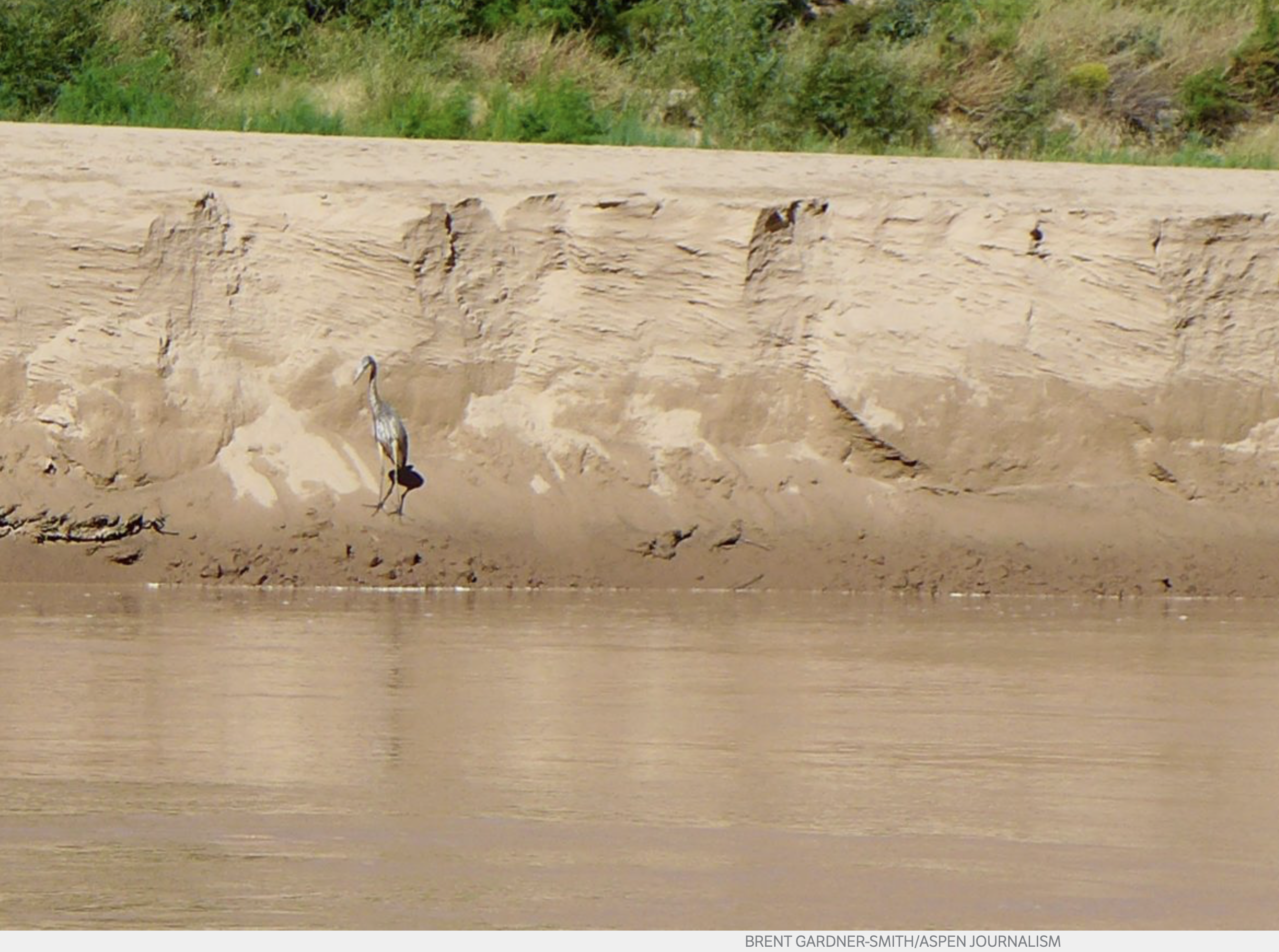
A heron on a big sandbank in upper Lake Powell, above Hite. As the big reservoir recedes due to almost 20 years of drought in the Colorado River basin, new sights are emerging. A regional effort to send more water into Lake Powell in a new regulatory pool of water is gaining momentum in anticipation of a regional water meeting in mid-December in Las Vegas. Photo credit: Aspen Journalism/Brent Gardner-Smith
The directors of the Colorado River Water Conservation District voted Monday to endorse a new state policy regarding “drought contingency planning” designed to bolster water levels in Lake Powell and Lake Mead, with the larger goal of avoiding violating the Colorado River Compact.
The support of the River District board, which represents 15 Western Slope counties, was expected. The district’s general manager, Andy Mueller, spoke in favor of the policy before the CWCB directors unanimously voted to approve it Nov. 15 at a meeting in Golden.
Expected or not, the support by the River District board was seen a key step in the fast-moving effort to get the four states in the upper Colorado River basin, Colorado, Utah, Wyoming and New Mexico, and the three states in the lower river basin, California, Arizona and Nevada, to keep working together on a plan to keep the two biggest reservoirs on the river system functioning as intended.
Lake Powell today is 43 percent full. The giant reservoir formed by Glen Canyon Dam typically receives 10.3 million acre-feet of water flowing into it from the Colorado, Green and San Juan rivers each year. But annual inflows have been less than 5 million acre-feet for seven of the past 18 years, and have been below average for 15 of the past 18 years, according to a summary of recent water meeting at Colorado Mesa University prepared by Ken Ransford, the secretary of the Colorado River Basin Roundtable.
Water from the Roaring Fork, Fryingpan and Crystal rivers flows into the Colorado River in Glenwood Springs.
Water managers say three more dry years could leave the reservoir too low to make hydropower at the dam, and then if drought continues, too low to release enough water to meet the upper basin’s obligations to the lower basin, which could trigger a compact call.
The timing of the River District’s vote Monday was also important, as the seven basin states are working to gain basin-wide consensus on a series of related drought contingency agreements by the annual meeting of the Colorado River Water Users Association in Las Vegas from Dec. 12 to 14.
And if the River District had not endorsed the state’s new policy, it could have signaled discord on the plans between Colorado’s Western Slope and Front Range.
“We recognize that these policies are far from perfect. We do, however, believe that they represent a good-faith effort by the CWCB at demonstrating leadership and a commitment to many of the policies adopted by our board,” Mueller said in a Nov. 23 memo to the district’s board of directors.
The new Colorado policy, which has now been endorsed by the River District, voices the state’s support for setting up a regulated pool of water in Lake Powell designed to boost reservoir levels.
That pool of water — a tiny bucket within a very big bucket — is to be filled through a voluntary, temporary and compensated demand management, or water-use reduction, program that has yet to be set up across the upper basin states.
Colorado’s new policy also says if the voluntary program does not send enough water to the new pool in Lake Powell, and a mandatory curtail program is necessary to avoid a compact call, that such a mandatory program be set up only after a public process.
The policy also says that the voluntary program will be designed to cut back on water use on both sides of the Continental Divide so as to minimize economic hardship being focused on just one part of the state.
“One of the primary areas of concern for the West Slope conservation districts is that any demand management program not have disproportionate impacts on the West Slope and that water contributed to such a program be produced in rough proportion to the post compact depletions to the Colorado River system from both sides of the continental divide,” wrote Mueller in his Nov. 23 memo.
Marti Whitmore, who represents Ouray County on the River District board, put that concern in plain terms Monday: “I want the Front Range to actually have to turn off the spigot, so to speak.”
A raft coming out of Cataract Canyon into upper Lake Powell encounters the bathtub ring left by the receding reservoir. As Lake Powell, and Lake Mead, continue to see less and less water, it’s prompting water managers, including those at the Colorado River District, to coordinate on ways to send more water downstream. Photo credit: Aspen Journalism/Brent Gardner-Smith
Soft on prior appropriation?
The River District’s endorsement of the new state policy was not without some contention, including issues raised by Glenn Porzak, the water attorney for the Eagle River Water and Sanitation District and the Upper Eagle Regional Water Authority, which together provide water for 65,000 users in the Vail and Eagle County region.
Porzak had concerns about whether the state policy represented a retreat from the prior appropriation doctrine in Colorado, which is summed up by the phrase “first in time, first in right.”
In his letter, Porzak said language in the new state policy about potential future compact administration “is an obvious effort to protect transmountain diverters with junior water rights and should be alarming to all senior West Slope water managers, owners and organizations charged with protecting those rights.”
Porzak also questioned whether the CWCB would advocate in the future for strict adherence to the prior appropriation system, where junior water rights are cut off before senior rights, and especially water rights in use before the 1922 Colorado River Compact was signed.
“The lack of commitment to the state’s constitution and laws demonstrates its intent to deviate from them should a compact call occur,” Porzak said in his letter.
The River District board discussed Porzak’s concerns and then ended up taking three votes on carefully worded motions, all of which passed.
The first vote was to formalize the River District’s support for the regional drought contingency planning efforts and the setting up a voluntary demand management program in Colorado and the other upper basin states.
That motion also said “the River District will continue to advocate on behalf of West Slope water uses in future discussions concerning a demand management program.”
The second vote was to voice the district’s support for a public process in the event that a mandatory effort was needed.
And in response to Porzak’s concerns, that motion also said the River District will only support curtailment policies or actions that are consistent with the district’s own policies regarding the Colorado River Compact.
The River District’s policy, last updated in July, recognizes that some flexibility in how the prior appropriation system is administered may be needed in the future, given the complexity of actually curtailing water rights across four Western Slope river basins based strictly on their priority date.
The third vote taken Monday by the River District board was to support, in concept, the short piece of federal legislation that is soon to be introduced and is required to allow the drought contingency planning efforts to take effect.
Editor’s note: Aspen Journalism covers water and rivers in collaboration with The Aspen Times and other Swift Communications newspapers. The Times published this story on Tuesday, Nov. 28, 2018.
Colorado transmountain diversions via the State Engineer’s office
A public agency and a powerful farmer are gearing up for a high-stakes court battle to determine who owns the largest share of Colorado River water in the West, complicating the river’s future as seven western states scramble to avoid severe water shortages.
There’s a long history of fighting over water in California’s Imperial Valley, which has a legal right to more than 1 trillion gallons of Colorado River water each year — twice as much as the rest of California, and as much as Arizona and Nevada combined.
But officials at the publicly owned Imperial Irrigation District say the lawsuit brought against the agency by Mike Abatti, an influential farmer, could be a game-changer for the U.S. Southwest. They say Abatti’s lawsuit could shift control of the Imperial Valley’s water supply away from the public and toward a small group of landowning farmers.
Abatti has made the same argument.
“This case presents a pivotal struggle over the ownership and control of what may be the most historic and invaluable water rights in the Southwest United States,” Abatti’s lawyers wrote in their opening brief to an appellate court in San Diego last month.
Abatti’s lawsuit is a key issue in next week’s election for one of five seats on IID’s board of directors. Norma Sierra Galindo, the incumbent, has pledged to keep fighting the lawsuit, frustrating farmers who have urged IID to settle the case. Galindo’s challenger, Carlos Zaragoza, recently received campaign contributions from Abatti’s brother Jimmy, and from another farmer who has leased land from Abatti. Zaragoza has refused to discuss his views on the Abatti lawsuit or to say whether he would support a settlement.
“As to who owns the water, that’s to be determined by the courts,” Zaragoza said at a debate earlier this month. “I would support the law as determined by the courts.”
Abatti won a sweeping ruling in Imperial County Superior Court last year. The ruling was written by Judge L. Brooks Anderholt, who presided over the case despite his long history of business and social ties to members of the Abatti family, as The Desert Sun has reported. Anderholt ruled that IID “holds mere legal title to the water rights,” and that farmers “own the equitable and beneficial interest in the water rights.” He described the farmers’ interest in the water rights as “a constitutionally protected property right.”
[…]
The Abatti case has also pitted Imperial Valley city governments, industrial developers and labor unions against powerful farmers. Agriculture uses 97 percent of the valley’s Colorado River water, and critics of Abatti’s lawsuit say giving farmers more control would cripple IID’s ability to guarantee a reliable water supply for cities and industry. The city councils of El Centro and Calipatria have passed resolutions supporting IID in the lawsuit, at the urging of a group called the Imperial Valley Coalition for Fair Sharing of Water, which was organized by former Imperial County supervisor Wally Leimgruber.
“Without access to water, there is no reason for the valley to exist,” El Centro Mayor Cheryl Viegas-Walker said last month, before the city council voted 5-0 to support IID’s position. “We know that the municipalities within Imperial County use only 3 percent. But that 3 percent is the lifeline for every single person that lives within Imperial County.”
My parents have a small garlic farm in Western Colorado in the valley of the North Fork of the Gunnison River. They bought the place just over a decade ago, along with a couple of shares of water from the ditch which runs through their property. It’s a nice little plot of rural Colorado with good dirt and nice views, but it wasn’t until this terribly dry summer that they realized how valuable the land is. The Farmers Ditch, diverted from the North Fork near Paonia, has some of the most senior rights in the valley. They are water-rich in an arid world.
Since white settlement began here back in the late 1800s, the communities of the North Fork have revolved around coal and agriculture. Three underground coal mines churned away for decades, their bounty loaded upon mile-long trains headed for power plants in the Midwest and beyond. Paonia and the surrounding mesas have long been renowned for fruit, vegetables and, for a time, marijuana.
After surging to a peak just over a decade ago, coal began its hasty, nationwide decline, and now only one of three mines in the North Fork is still operating. Meanwhile, small-scale agriculture has taken over as one of the main economic pillars of this idyllic valley: Cherries, peaches, hops and hemp. Agricultural interests also are a strong political force rising up in resistance to proposed oil and gas drilling because of its detrimental effect on the water, which is becoming more and more precious in a warming world.
Thanks to the dramatically sere appearance of the natural landscape, the North Fork Valley provides a stark visual reminder of the importance of large-scale irrigation in these parts. A ditch along a hillside becomes a sharp divide between the dry, sparse, dusty dobie-land above the ditch; and green, grassy, cottonwood- and cattail-strewn land below it. This is true even where no active irrigation is taking place; the ditches are generally so leaky that they create artificial wetlands in areas that are distant from fields or crops or lawns.
Most of the irrigation water comes from the North Fork, which begins at the confluence of Muddy Creek and Anthracite Creek. Paonia Reservoir sits just above the confluence, on Muddy Creek. Typically the reservoir fills up during the spring and early summer, during which the natural flow in Anthracite Creek is adequate to fill all of the downstream ditches. When Anthracite starts to wane, water is released from the reservoir to keep the ditches flowing, usually into August and sometimes even until late October. In late June or early July the river’s total flow reaches equilibrium with the volume diverted from it, causing the river through Paonia to dry to a tiny, warm trickle that is good for sustaining only crawdads and mosquito larvae.
Even more shocking than the annual desiccation of the riverbed is the way in which so many water rights holders continue to pull their maximum share from the ditch, even if it’s not needed, even if they have no crops or even lawn to irrigate. “Use it or lose it,” the saying goes. Meanwhile, only a handful of the small-scale farmers have bothered to install more efficient irrigating systems, and most of the ditches continue to leak like sieves. That may be fine in a time of abundance, but these are times of increasing scarcity.
Paonia Reservoir — which gets its water from aptly named Muddy Creek — is filling up with mud. When constructed in 1962, the reservoir had 21,000 acre feet of capacity; today only 14,000 acre feet of capacity remain. So the amount of water available to irrigators is diminishing, even during wet years. But this year was one of the driest on record, which prompted downstream, senior water rights holders to put a “call” on the river in mid-June, at least a month earlier than usual, forcing junior, upstream holders to stop diverting water. By the time August rolled around, all but a few ditches in the North Fork had been shut down or had their flows drastically curtailed. Farmers Ditch, meanwhile, kept running right up to the brim.
The farmers of the North Fork Valley make up a fairly tight-knit community. They share seedlings and knowledge, hay balers and tillers, trade garlic for meat. So one would expect them to respond to a water crisis in much the same way, with the haves on Farmers Ditch sharing their bounty with the have-nots whose ditches ran dry. At the very least, you’d expect the haves to cut down on their own water use, even if just out of respect for their less fortunate neighbors.
But that’s not how it works in the arcane world of Western water. This summer most of the folks on Farmers Ditch carried on like they would any other year, using up their entire share of water and letting whatever they didn’t use run off across the mesa tops to evaporate and seep into the earth while their dry-ditch neighbors looked on helplessly. I watched one landowner wastefully dump a steady stream of irrigation water on his dusty horse pasture, turning it into a nasty mud bog where only a few thistles grew, while a mile away crops wilted. Wealth-inequality may be the scourge of our nation, but it’s water inequality that will increasingly plague the arid West.
The ostentatiously water wealthy are not entirely to blame. I’m confident that most of them would have been happy share their bounty if they could. But there’s no simple mechanism for this kind of cooperation. My parents can’t just turn a valve and send their water across the valley to their fellow farmer. The system wasn’t designed that way. It is the system that needs changing.
“The solution is, in a sense, straightforward,” writes John Fleck in his book Water is for Fighting Over, and Other Myths About Water in the West. “Everyone in the Colorado River Basin has to use less water. But no one will voluntarily take such a step without changes in the rules governing basin water use as a whole to ensure that everyone else shares the reductions as well—that any pain is truly shared. We need new rules. Absent that, we simply end up with a tragedy of the commons.”
Fleck’s referring to the macro of the Colorado River Basin here, but it also applies to the micro of irrigation districts everywhere. New rules, new systems, new ways of operating are needed that would incentivize efficiency and that would allow the Farmers Ditches of the world to share with the others in the community who aren’t so fortunate.
When it comes to water, though, we Westerners tend to get entrenched in the use-it-or-lose-it culture, which is anathema to cooperation and to efficiency. Still, this is not unsurmountable. When pushed up against the wall, Westerners have become more limber in their approach to water. Take Las Vegas, which has managed to cut per capita water use enough so that it’s been able to grow its population without robbing Great Basin farmers of their groundwater — at least so far.
And then there’s another, smaller instance of cooperation that bears mentioning. After the Sunnyside Mine upstream from Silverton, Colorado, shut down in 1991, the owners put a boxcar-sized plug, or bulkhead, into the mine’s main tunnel to keep the 1,600 gallons-per-minute of acid mine drainage from going into the Animas River watershed.
Not long afterward, the region suffered through what at the time seemed like a horrible drought, prompting a downstream ditch company to make a call on the Animas River.
That’s when Silverton discovered that the founding fathers had failed to file for water rights back in the early days of the town, leaving the town with some of the most junior rights on the entire river. They faced the very real prospect of having to shut down their municipal water intakes. Instead, the Sunnyside Mine stepped up and opened the valve on the giant plug, releasing enough water (and treating it) to satisfy the downstream call, and buying Silverton time during which it could seek out a long-term fix. (Then the mine shut the valve down again and water backed up in the mine to disastrous effect, but then, that’s another story.)
It’s this sort of out-of-the-box, pragmatic, cooperative thinking that the West is known for, and that has helped many a community transition successfully away from extraction-based economies. Now the warming, drying region is faced with a much bigger, tougher transition, with even higher stakes.
Jonathan P. Thompson is a contributing editor at High Country News and the author of River of Lost Souls: The Science, Politics, and Greed Behind the Gold King Mine Disaster. Get a copy of River of Lost Souls.
“(Thompson) combines science, law, metallurgy, water pollution, bar fights and the occasional murder into one of the best books written about the Southwest in years.”
— Andrew Gulliford, historian and writer, in The Gulch magazine.
San Luis People’s Ditch March 17, 2018. Photo credit: Greg Hobbs
Greg Hobbs
Greg Hobbs at the Colorado Water Congress January 2012
David Robbins and J.C. Ulrich (Greg Hobbs) at the 2013 Colorado Water Congress Annual Convention
Friend of Coyote Gulch, Greg Hobbs, sat down with John Ingold of the Colorado Sun to talk water history and the future of the Colorado River Basin. Here’s an excerpt:
Colorado’s system governing water use predates the state itself — the oldest water rights in Colorado date to the 1850s. And it is so closely linked to the state that, even when it is used elsewhere, it is often called the “Colorado Doctrine.”
But can it survive perhaps the greatest challenge in its history — a double-whammy of drought and population growth?
To answer that question, The Colorado Sun sat down with retired state Supreme Court Justice Gregory Hobbs, one of Colorado’s foremost minds on water law. Hobbs has 45 years of experience practicing water law in Colorado, and he continues to serve as a senior water judge and mediator.
First, some background: This spring, an influential water think tank, the Colorado River Research Group, released a report calling on water wonks to stop using the term “drought” to describe what is happening in the West. Drought implies something temporary, the report argued. But these changes show no sign of being temporary.
“For that, perhaps the best available term is aridification, which describes a period of transition to an increasingly water scarce environment,” the group stated in its report.
Meanwhile, the Colorado State Demography Office projects that Colorado will add 3 million people by 2050, bringing the population above 8 million.
This is a worrying prospect for water in Colorado — party to nine interstate water compacts and home to thousands of individual water rights, each meticulously ordered in priority from oldest to youngest. And the strain may already be starting to show.
The fiscal year that ended in June 2017 — the most recent for which data is available — had the most claims and filings in state water court since the similarly parched year of 2012, according to a Colorado Sun analysis. Thornton and Fort Collins are currently locked in a testy battle over how to move water that Thornton has the rights to out of the Poudre River, lifeblood of Fort Collins. And, according to reporting by Water Education Colorado, a New York hedge fund has spent millions buying up senior water rights on Colorado’s Western Slope — apparently betting on future shortages.
Does Hobbs think the Colorado Doctrine is built to withstand this kind of stress? The following Q&A has been condensed and edited for clarity, readability and brevity. At one point, Rob McCallum, a spokesman for the Colorado Judicial Branch who helped arrange the interview and sat in on it, also chimes in.
Hobbs talks about complicated water compacts and delivery systems as casually as discussing high school memories with an old friend, and it can be hard to keep up. So there are a few Colorado Water 101 explainers sprinkled in to help out.
Gregory Hobbs: The (Colorado River) Compact has really been tested in recent years with sustained drought. But it’s working.
Colorado Sun: At what point does it break?
GH: It doesn’t.
CS: It can’t?
GH: No. Not unless one of the states convinces the other six to renegotiate the compact; it’s perpetual. … Congress could try to override it. But I just don’t see it happening because Congress agreed to the compact.
So this is the essence of state-federal sovereignty, these nine interstate compacts that Colorado is a part of. The alternative is litigating in the U.S. Supreme Court for an allocation. It’s an amazing thing that in this 16-year drought, the target release of 8.25 (million acre-feet per year) out of (Lake) Powell has been met or exceeded.
In late August, as reservoirs levels declined across the American Southwest, Erin Light issued something common in most river basins of Colorado but which had never been done on the Yampa River. She issued a “call.”
When a call is issued, those with newer or younger water rights must cease their diversions from the river and its tributaries until the older or more senior rights are satisfied. This system is called prior appropriation. Eighteen states in the West use aspects of prior appropriation to sort out who gets how much water and when.
Light, as the division engineer for Colorado Division of Water Resources, administers the labyrinth of water rights in the Yampa River Valley. Water goes to ranches, a power plant, and other purposes, each occupying a specific place in the pecking order as determined by volumes, locations and, above all, date of adjudication. That’s the way it works when a river is under administration. Some Colorado rivers have been under administration since the late 1800s.
Until this summer, the Yampa was different. Those with legally adjudicated water rights took what they thought was theirs. Calls had been placed on tributaries, but not the river itself.
Then in late August, Light announced that those with water rights on the rivers’ main stem awarded since 1951 would have to cease diversions until those older, or seniors, had been satisfied. By mid-September, as irrigators slowed their demands and cooler temperatures eased losses from evaporation and transpiration, Light edged the call back to those rights junior to 1960. Last week, she suspended the call altogether.
Droughts hit the Yampa and many other river basins in Colorado hard this year. But this drought may best be viewed as part of an extended 21st century drought caused more by temperature increases than precipitation declines. It’s part of a clear trend of a warming and more erratic climate.
Ted Kowalski says the water call on the Yampa should be understood within the context of these hotter, drier times in the American Southwest. A former Colorado water official who is now senior program officer for the Walton Family Foundation’s Colorado River Initiative, Kowalski calls the Yampa River the first domino to fall.
Lower streamflows in all the rivers of the Colorado River Basin that produce declining reservoir levels represent the additional dominoes.
This is starkly demonstrated, says Kowalski, by the fact that reservoir storage in the Colorado River Basin has reached its lowest level since the late 1960s. That’s when the newly created Glen Canyon Dam was starting to create Lake Powell.
“All of this underscores the importance of developing and adopting and agreeing to drought contingency plans so that we can effectively manage if and when there is less water in the system,” says Kowalski. The work begins, he says, with conservation.
Conserving water in the 20th century
Far into the 20th century, conservation had a different connotation in the West. Managing water in the Colorado River Basin meant building dams and creating reservoirs, all with the intent of ensuring none of the water was “wasted” by flowing into the ocean.
Hoover Dam plugs the Colorado River on the Nevada-Arizona border. Photo December 2012/Allen Best
Nearly all this major hydraulic engineering was done on the tab of the federal government. Downstream, first Powell and then Mead, the second largest and largest reservoirs in the nation, respectively, provide most of the storage. If separated by 300 miles and the Grand Canyon National Park, the two reservoirs fundamentally operate in tandem, as a Colorado River Research Group report in August noted. They are “essentially one giant reservoir (bisected by a glorious ditch),” the report said in a nod to the Grand Canyon.
Reservoir levels rise after big snow years, but in the 21st century the more common trend has been decline.
Evidence emerging in recent years suggests the Colorado River’s decline can best be explained by rising temperatures instead of reduced precipitation. In a 2017 paper, Brad Udall, a senior water and climate research scientist at Colorado State University, and Jonathan Overpeck, the dean of the School for Environment and Sustainability, attributed two-thirds of water declines to temperature rather than precipitation. Not only is more water evaporating, they said, but plants have been transpiring more water.
“This is the kind of drought we will have to deal with in the future,” Overpeck said at a water conference in Santa Fe during April.
Doug Monger testifies to the warmer weather. A native of the Yampa Valley, he remembers 45-below temperatures, once in the 1980s for two days straight. Down the valley in Maybell, the temperature in that same cold spell hit 61 below. (It had also hit that same low in 1979.)
“I always prayed for climate change and global warming,” he jokes.
Now, he’s getting that warming. “We never had 90 degrees, and now it’s nothing to have 90-plus days for five or six days in a row.”
That heat has been taking a toll on the snow. About three-quarters of the precipitation in the Colorado River Basin originates as snow. Colorado itself provides 70 percent of the water in the river.
In the Yampa Basin, most of the snow collects in an elevation band of between 8,000 to 10,000 feet. The river originates on the flanks of the Flattops Wilderness Area as the Bear River, gurgles playfully along at the foot of the Gore Range and then, drawing more water from the usually snow-laden Park Range, hooks westward at Steamboat Springs for a 100-mile journey to Dinosaur National Monument.
Beyond Dinosaur, the Yampa’s water eventually flows into the Utah desert and Lake Powell.
The Park Range has a reputation as the snowiest place in Colorado. A gauge at 10,285-foot Buffalo Pass, located northeast of Steamboat Springs, reported 80 inches of water contained in the much deeper snowpack by early May on a recent, snow year.
When spring arrives in years such as that, the Yampa gushes through Steamboat Springs well into summer. Flows needed for commercial tubing during summer represent one measure of winter’s legacy. Tubers are not allowed to use the river until flows drop below 700 cubic feet per second. That commonly isn’t possible until after the Fourth of July.
This year, snowpack was better than in Southwest Colorado. Still, it came weeks early and was altogether modest in its surge. Tubing season in Steamboat began June 11. Commercial tubing season ended a month later, when it is usually starting. City and state wildlife officials asked all tubers and others river users to stay out. The river was dropping to 85 cfs, considered a critical threshold, and warming as it did, hitting 75 degrees, reported the Steamboat Pilot at the time.
“If the river’s getting above 75 degrees Fahrenheit, the aquatic life is severely stressed, and this is the time of year when they’re feeding, and they’re getting ready for winter,” said Kelly Romero-Heaney, the city water resources manager for Steamboat Springs.
No relief came with summer, hot and dry. Clouds produced just a few drops.
Water infrastructure in 21st century
Light, the water engineer on the Yampa since 2006, tells a complicated story of why the first call was made this year and not during prior years. Water rights always get complicated. The immediate repercussion will be that investments will necessarily be made in the devices that assure flows. In the Yampa River it was a point of pride that there was no call, unlike places like the South Platte Basin. But almost everybody agrees it was inevitable.
The Yampa River had almost no flows at Deerlodge Park, at the entrance to Dinosaur National Park, when this photo was taken in mid-August. Photo/Erin Light via The Mountain Town News
That inevitably stems in large part to trends in hydrology. In 20th century hydrologic records, three drought years stand out: 1935, 1955, and 1977. Now, in this still young century, there have been three more: 2002, 2012 and 2018.
“When you look at temperatures that were 5 to 10 degrees above average every day, that has to raise eyebrows about what the climate is saying,” she says.
Changes in the Yampa River Basin have not been well documented, but anecdotally at least comport with statewide trends reported in a 2015 report to the Colorado Water Conservation Board. That report, “Climate Change in Colorado,” says statewide average temperatures had increased 2 degrees F during the previous 30 years, with daily minimum temperatures warming more than maximum temperatures. Timing of snowmelt and peak runoff had shifted earlier in spring by one to four weeks. Snowpack as measured by April readings had been mainly below-average since 2000.
Anecdotal evidence of this abounds around Steamboat. Local ranchers long measured a winter’s severity by how deep it accumulated on their barbed wire fences. The 20th century produced many three-wire winters, enough snow to hit the top strand. Three-wire winters seldom come anymore. Last winter snow failed to reach the bottom wire. In some places, the was no snow at all on the ground, says Ken Brenner, who grew up on a ranch south of Steamboat Springs and is now president of the Upper Yampa River Water Conservancy District Board of Directors.
Light says the Snotel automated snowpack measuring sites fail to tell the full story. The stations maintained by the federal government’s Natural Resources Conservation Service record snow and water content at 8,000 to 10,000 feet. Some years, they report robust snow that cannot be seen in snow depths on the valley floor. This leaves locals wondering how this snowpack could be anywhere near normal. The rising levels for snowpack argue for a different monitoring system, says Light, one that captures dynamics of the low-elevation snowpack.
Water infrastructure for 21st century climate
Climate change models predict sharply increased temperatures in coming decades, Models also predict greater variability of precipitation, more extremes of both wet and dry. That could provide an argument for more reservoirs. The Yampa River has just 2 percent of Colorado’s reservoir capacity, but the river provides a much larger percentage of the state’s overall flows. The Gunnison River, with about the same runoff on average, has three giant federal dams, part of the same Congressional authorization in 1956 that created Lake Powell.
The Yampa, White, and Green Basin Roundtable, a decision-making body created by the Colorado Legislature, agree that instead of giant reservoirs, the basin could benefit from smaller reservoirs, discretely located, such as on tributaries, to serve specific needs, reports Light, the state’s liaison to the roundtable.
Monger does see the need for storage on the Yampa River. It could help Colorado manage its water so as to ensure it can meet its commitments to other states in the Colorado River Basin. “Let’s keep it in my backyard rather than sending it down to Lake Powell and have it be subject to the Bureau of Reclamation and the Department of Interior,” says Monger, a Routt County commissioner as well as a delegate to the Colorado River Water Conservation District. Higher elevation storage, he says, will reduce evaporative losses from Lake Powell, about six and a half feet a year off the surface.
About 90 percent of the Yampa’s total annual flows go downstream out of Colorado, ultimately to Lake Powell. That reservoir provides Colorado and other upper-basin states in the Colorado River Basin the ability to meet requirements for delivery of 8.3 million acre-feet annually to Arizona, California, and Nevada at Lake Mead.
That obligation of 7.5 million acre-feet plus the upper basin’s share for Mexico was derived by negotiators who met at a resort near Santa Fe in 1922. Disregarding contrary evidence, they assumed at least 16.5 million acre-feet average annual flows in the river and probably more. That rarely has been the case. In the hotter, drier 21st century, flows have been just 12.4 million acre-feet, say Eric Kuhn, former general manager of the Colorado River Water Conservation District.
At a recent conference called “Risky Business on the Colorado River,” Kuhn warned against overdrawing Lake Powell, Lake Mead, and other reservoirs.
“When you build reservoirs, you have to have some water. You have to have a little bit of money in the bank. We can’t bankrupt the system. We have to find ways to cut back before we bankrupt the system.”
In Vail on Wednesday, Kuhn took his vision of difficulty for the Colorado River a step further. As long as greenhouse gas emissions go untamed, he said, “there is no bottom” to how hot and how dry the Colorado River Basin could become.
It’s not that the past hasn’t also been drier. Kuhn looks to the past to warn against even more difficult times on the Yampa River and in the Colorado River Basin altogether. The evidence comes from examinations of batches of trees at eight different sites in the Colorado River Basin above Lee Ferry, located just above the Grand Canyon and below Lake Powell.
Dendrochronologists can estimate precipitation by the growth of tree rings. Using that technique, they have charted wet and dry periods since 1434.
Tree-ring research indicates there have been much more severe 19-year droughts in the Colorado River Basin than the current one—and without the impact of human-induced higher temperatures. Graphic via The Mountain Town News
“A number of folks claim that the current 19-year period of 2000-2018 is the driest 19 year period on the Colorado River. That’s nonsense,” says Kuhn, pointing to the graph. In the past there have been droughts both longer and deeper. (Above, see estimated river flows at Lee Ferry, at the top end of the Grand Canyon, from 1434 to 2018. For underlying data, see http://treeflow.org).
Those droughts occurred without the rising temperatures of today. “If these past 19-year droughts were to happen with today’s temperatures,” he adds, “things could be much worse.”
This article was published in the Oct. 4 issue of Mountain Town News, a weekly e-magazine. To subscribe, see options in the red boxes in the top-right corner of the http://mountaintownnews.net webpage.
Here’s the release from The Rocky Mountain Collegian (Julia Trowbridge):
With the “Arid West” experiencing climate change and a growing population, it’s time to look at water rights. Colorado State University professors are joining up with researchers across universities and disciplines in Colorado, Nevada and Arizona to do just that.
In partnership with the University of Nevada Reno, Arizona State University, Northern Arizona University and the Desert Research Institute, CSU researchers received a $4.9 million grant from the United States Department of Agriculture in order to create an economic model of how water rights should be allocated in the long term.
This topic has come up due to changes in population growth and climate change, especially in sustaining and increasing agricultural productivity, according to the research proposal.
The research centers around the concept of water rights. Water rights refer to a business’s right to irrigate water. Dale Manning, an agricultural and resource economics professor at CSU, said the longer the business has had the water right, the more secure the business’s water supply claim is. This is important because people with more secure rights get priority access to water resources.
“What happens is, if you’re a senior water right and can’t get the water you’ve historically used, you can tell all the people who are more junior to you, who started diverting water after you, to stop diverting,” Manning said.
The research project focuses on the water basins that the researchers are around: the South Platte river basin, the Verde River basin and the Walker river basin. Although the economic models are being designed around these basins, the research team wants these models to be tailored to any area that relies on surface water, Manning said.
Agriculture diverts the most water in the west, and it diverts anywhere from 70 to 90 percent of the water supply each year, said Christopher Goemans, an agricultural and resource economics professor at CSU. With the expansion of population, agricultural, municipal and industrial areas are forced to compete for the water resources available.
“Any institution that we come up with is tricky because you want to have reliability built into the system so that if I’m a city or a group of cities … I know what my rights are to certain amounts of water,” Goemans said. “But at the same time, we also want fluidity, no pun intended, in the system because as conditions change, whether on the demand or the supply, we want the system to be adaptable to those conditions.”
The demand for water changes in relation to population changes in an area. Manning said through potential options like conservation and reservoirs, the research team is looking into how in the future the amount of water needed can be best maintained.
“Having those different options is actually good, we aren’t limited to one thing to adapt,” Goemans said. “It’s not only building infrastructure, it’s not only telling people to use less, but it’s a combination of all that.”
The side of demand not only involves economic thought, but also social sciences and hydrology engineers. This is where the importance of interdisciplinary work comes in, Manning said.
“You can’t really do this without doing interdisciplinary work,” Manning said. “We don’t model hydrology, but somebody on this project will, and that’ll help us create the supply side of our economic model.”
The research group aims to make a long-lasting impact on how water resources are allocated in the future. With the increased uncertainty of the supply of water, they want to create a reliable yet fluid system for the balance between agricultural, municipal and industrial water needs.
“It’s not just academics and it’s not just one state,” Goemans said. “There’s this huge outreach component. We’re working with local water authorities and each of the states to try to make sure (the research) is as useful for them as possible.”
Collegian reporter Julia Trowbridge can be reached at news@collegian.com or on twitter @chapin_jules.
Water experts say that if the ongoing drought persists, Lake Powell could be empty within three years, and call could be placed on the upper basin to curtail water rights. To avoid the chaos such an unprecedented call might bring, state officials are discussing how a more orderly, but still mandatory curtailment of water uses, might need to be implemented. A wall bleached, and stained, in Lake Powell. Photo credit Brent Gardner-Smith @AspenJournalism.
A state-imposed mandatory curtailment of water in the Colorado River Basin within Colorado was discussed as a looming possibility during a meeting of the Colorado Water Conservation Board on September 19 in Steamboat Springs.
Representatives from the Western Slope told the statewide water-planning board that while they favor creating a new legally protected pool of water in Lake Powell and other upstream federal reservoirs to help prevent a compact call on the river, they have significant concerns about the pool being filled outside of a program that is “voluntary, temporary and compensated.”
However, Front Range water users told the board that a voluntary program may not get the job done and that a mandatory curtailment program, based on either the prior appropriation doctrine or some method yet to be articulated, may be necessary to keep Lake Powell and Glen Canyon Dam functioning so Colorado, Utah and Wyoming can deliver enough water to California, Arizona and Nevada to meet the terms of the 1922 Colorado River Compact.
“With the repeat of historic hydrology beginning in the year 2000, Lake Powell will be dry, and when I say dry I mean empty, within about three years,” Jim Lochhead, CEO and manager of Denver Water told the CWCB board.
Lochhead said that while a voluntary demand management program might help bolster water levels in Lake Powell, “it doesn’t necessarily solve the problem.”
“So we may need — I know we don’t want to implement — but we may need other mechanisms to accelerate the creation of water into Lake Powell in the event of an emergency,” Lochhead said. “This is not something that Denver Water wants, or is asking for. What we are asking for is that the contingency plans be put into place. We need to have those plans in place before the system collapses.”
On Wednesday, Brent Newman, the chief of CWCB’s Interstate, Federal, & Water Information Section emphasized that neither they, nor the state attorney general’s office, is at this point “assessing, pursuing or recommending to the CWCB board any type of involuntary or ‘anticipatory’ curtailment scenario.”
And yet, such scenarios are on a lot of people’s minds.
(Please see related memo, slides and audio from the meeting. The audio is via YouTube, as provided by CWCB. The file opens well into the discussion, so click back to the beginning of the file, which opens just after the agenda item began, with brief introductory comments from CWCB Director Becky Mitchell. It’s well worth listening to. Also please see related story from Sept.18.).
The looming possibility of mandatory curtailment of water use has raised concerns among Western Slope water managers, who feel that such cuts could harm Western Slope agricultural, such as this hay filed in the Yampa River basin. However, as water levels continue to drop to record lows in Lake Powell, mandatory curltailments are being discussed as a real possibility, especially by Front Range water managers. Photo credit: Brent Gardner-Smith/Aspen Journalism
At hand
Lochhead said Denver Water wants to see a voluntary, temporary and compensated program created as a “first priority,” but also said “I also don’t think that by not talking about mandatory curtailment we can pretend the problem will go away. We need to be thinking about it, and we need to be thinking about it proactively.”
However, Western Slope water interests as represented by the Colorado River Water Conservation District and the Southwestern Water Conservation District are concerned that if a new storage pool is created in Lake Powell, and a mandatory curtailment program is used to fill it, it could have dire consequences for agriculture on the Western Slope.
NPR panel discussion of The Future of Water at CSU May 24, 2016. L to R: Patty Limerick, Roger Frugua, Melissa Mays, Paolo Bacigalupi, Kathleen Curry, and host Michel Martin.
“This is our livelihood,” Kathleen Curry, a rancher in Gunnison who serves on the Gunnison River Basin Roundtable, told the CWCB. “This water is what we depend on. If we move in the direction of mandatory curtailment, and it isn’t equitable, you are going to have significant impacts to the water users in the state of Colorado, especially on the Western Slope.”
The two regional Western Slope water conservation districts had drafted a resolution they wanted the CWCB to adopt Wednesday, which did not happen, as the CWCB declined to vote on it.
The resolution stated that any mandatory curtailment program would be developed on a “consensus basis” with the two districts at the table, and not just be a directive of the state.
However, Bennett Raley, the general counsel for the Northern Water Conservancy District, which provides water to nearly a million people in northeastern Colorado, said the state, as a sovereign entity, should not be constrained by consensus.
He also said that mandatory curtailment may well be necessary in Colorado.
“If the drought continues, there are two paths,” he told the CWCB board. “If there is an infinite source of money, then voluntary works. Great, we’re all happy. If the drought continues and there is not an infinite source of money, then the state will go to mandatory. The Supreme Court will ensure that, sooner or later, it’s not a question.”
Part of the fear of such a mandatory program is that hardly anyone, outside of perhaps the state engineer, knows what it would look like.
“Ultimately it’s a state decision, it’s a decision of the state engineer as to how water rights would be curtailed to meet the state’s obligations under the Colorado River Compact,” said Lochhead, when asked after the meeting how mandatory curtailment would work. “The short answer is, I don’t know. There are a lot of questions and viewpoints.”
Lochhead did say Denver Water is willing to “work with the state and with the West Slope to ensure that any curtailment doesn’t disproportionally impact any region of the state, whether it’s on the West Slope or the Front Range, and that essentially the same rules apply to everybody.”
Editor’s note: Aspen Journalism is collaborating with The Aspen Times and other newspapers in the Swift Communications group in Colorado on the coverage of rivers and water. The Times published this story on Thursday, September 20, 2018. The Glenwood Springs Post Independent also published it on Sept. 20, as did the Vail Daily.
Photo of Lake Powell in extreme drought conditions by Andy Pernick, Bureau of Reclamation, via Flickr creative commons
FromThe Colorado Sun (John Ingold). Click through to read the whole Q&A, here’s an excerpt:
A Q&A with former Colorado Supreme Court Justice Gregory Hobbs, one of the state’s top water experts
Colorado’s system governing water use predates the state itself — the oldest water rights in Colorado date to the 1850s. And it is so closely linked to the state that, even when it is used elsewhere, it is often called the “Colorado Doctrine.”
But can it survive perhaps the greatest challenge in its history — a double-whammy of drought and population growth?
To answer that question, The Colorado Sun sat down with retired state Supreme Court Justice Gregory Hobbs, one of Colorado’s foremost minds on water law. Hobbs has 45 years of experience practicing water law in Colorado, and he continues to serve as a senior water judge and mediator.
First, some background: This spring, an influential water think tank, the Colorado River Research Group, released a report calling on water wonks to stop using the term “drought” to describe what is happening in the West. Drought implies something temporary, the report argued. But these changes show no sign of being temporary.
Greg and Bobbie Hobbs
“For that, perhaps the best available term is aridification, which describes a period of transition to an increasingly water scarce environment,” the group stated in its report.
Meanwhile, the Colorado State Demography Office projects that Colorado will add 3 million people by 2050, bringing the population above 8 million.
This is a worrying prospect for water in Colorado — party to nine interstate water compacts and home to thousands of individual water rights, each meticulously ordered in priority from oldest to youngest. And the strain may already be starting to show.
The fiscal year that ended in June 2017 — the most recent for which data is available — had the most claims and filings in state water court since the similarly parched year of 2012, according to a Colorado Sun analysis. Thornton and [Larimer County] are currently locked in a testy battle over how to move water that Thornton has the rights to out of the Poudre River, lifeblood of Fort Collins. And, according to reporting by Water Education Colorado, a New York hedge fund has spent millions buying up senior water rights on Colorado’s Western Slope — apparently betting on future shortages.
Does Hobbs think the Colorado Doctrine is built to withstand this kind of stress? The following Q&A has been condensed and edited for clarity, readability and brevity. At one point, Rob McCallum, a spokesman for the Colorado Judicial Branch who helped arrange the interview and sat in on it, also chimes in.
Hobbs talks about complicated water compacts and delivery systems as casually as discussing high school memories with an old friend, and it can be hard to keep up. So there are a few Colorado Water 101 explainers sprinkled in to help out.
Gregory Hobbs: The (Colorado River) Compact has really been tested in recent years with sustained drought. But it’s working.
Colorado Sun: At what point does it break?
GH: It doesn’t.
CS: It can’t?
GH: No. Not unless one of the states convinces the other six to renegotiate the compact; it’s perpetual. … Congress could try to override it. But I just don’t see it happening because Congress agreed to the compact.
So this is the essence of state-federal sovereignty, these nine interstate compacts that Colorado is a part of. The alternative is litigating in the U.S. Supreme Court for an allocation. It’s an amazing thing that in this 16-year drought, the target release of 8.25 (million acre-feet per year) out of (Lake) Powell has been met or exceeded.
Many Indian reservations are located in or near contentious river basins where demand for water outstrips supply. Map courtesy of the Bureau of Reclamation.
The case that begins Tuesday in Maricopa County Superior Court involves the tribe’s past and present uses of water in the Little Colorado River Basin.
“The court is required to study the tribe, understand its history (and) culture, and make a determination what water is necessary for the tribe to have a permanent and livable homeland,” said Colin Campbell, an attorney representing the tribe.
A trial to look at future water uses will start in December 2019. A third trial examining ranch lands to the south of the Hopi Reservation will start in 2020 at the earliest.
The Hopi reservation is spread across three mesas in northeastern Arizona and circled by the much larger Navajo Nation.
On a parallel track are possible settlement talks between the Hopi Tribe, the Navajo Nation and the federal government. Negotiations have started and stopped over the years. Campbell said that in the last month, the federal Indian Water Rights Office started exploring a new attempt at a settlement.
He said that having Jon Kyl back in the U.S. Senate may help, because any settlement would require federal legislative action. Kyl worked on Native American water rights settlements during his previous stint in the Senate…
Colorado Division of Water Resources Division Engineer Erin Light delayed a call on the river, which would curtail users according to the doctrine of prior appropriation. The delay comes as water managers wait to see if increased flows in the upper Yampa reach Dinosaur.
The Yampa River has never been placed on call.
“The last pumps on the river were sweeping the river,” Light said of her Tuesday visit to the lower Yampa. “If you can imagine, literally, the Yampa River getting to the point that all the water has been taken out of it, is frightening and monumental. It never has happened.”
The Colorado Division of Water Resources places a call on a river when water rights owners do not receive the amount of water they have a legal right to. When a call is in place, some water users are forced to reduce or stop their use in order to send enough water downstream to fulfill the older water right.
Though reservoir releases have boosted flows in the upper Yampa near Steamboat Springs and Craig, it’s not clear if or when that water reaches the state line. Water managers aren’t positive that the gauge measuring flows at Deerlodge Park in Dinosaur National Monument has been providing an accurate reading.
On Tuesday, flows at Deerlodge Park fell to about 35 cubic feet per second. On Wednesday, it was up to about 70 cfs. Historically, the river flows at 351 cfs on the same date.
“It’s very extremely dynamic what we’ve got going on here,” Light said. “Obviously the rains affect everything. As much as we love the rain, it makes it difficult to see what’s going on in the system and what effects it’s going to have, but the reservoir water that was in the river before is now being reduced.”
The Colorado Water Trust has been releasing reservoir water to increase flows for aquatic habitat and recreational use. Tri-State Generation and Transmission added a significant boost in flows with released reservoir water to maintain power generation at Craig Station. As weekend rain has increased flows, the organizations have slowed their releases.
“They only have so much contract water, and they have to manage and budget that contract water for times when it’s critical for their purpose,” Light said.
Last week, total releases from Stagecoach Reservoir jumped from 65 cfs to 125 cfs, Light said. This fell back to 70 cfs Wednesday. Releases from Elkhead Reservoir between Hayden and Craig were also reduced, from 75 cfs to 25 cfs.
“The reservoir water and the rainwater has hit Craig, and it has hit Maybell, but it’s just not getting to Deerlodge,” Light said. “I’m hoping it will.”
The first to be curtailed are those that do not have a water right or do not have a measuring device on their water intake. Then, users with the newest water rights are curtailed, followed by those with older rights…
Light said the fact that, if it occurs, this would be the first call on the Yampa, and that has made her and the water users on the river “very cautious.”
“We’re very hesitant about this scenario,” Light said. “Who wants to be the one that’s been tagged as being the first one to actually request administration by our office?”
Grand Falls Little Colorado River, Spring of 2010.
From the Navajo Nation via the The Navajo Hopi Observer:
Navajo Nation President Russell Begaye met with Interior Department representatives Aug. 16, to discuss the framework for a settlement of Navajo water rights on the main-stem Colorado River and the Little Colorado River (LCR).
Also present at the meeting, held at the Office of the President and Vice President, were Navajo Nation Council Speaker LoRenzo Bates and various Council delegates. Navajo leaders met with the Secretary’s Indian Water Rights Office (SIWRO), an agency that operates under the Interior Department.
The Navajo Nation and the Hopi Tribe have been negotiating water rights for the Colorado River and LCR for decades without substantial resolution.
“We’re ready to move forward on this and we have been,” Begaye told SIWRO officials. “Establishing Navajo water rights to the main-stem and LCR is critical to the future of the Navajo Nation. I’ve been advocating for water allocations for homes, businesses and tribal operations, and for funding to build a pipeline to provide water to communities in the Western Agency.”
In June 2017, the Udall Foundation provided mediation between the Navajo Nation and the Hopi Tribe to work toward agreeable terms in a settlement. Although the tribes were able to gain certain consensus on some issues, they failed to come to an agreement.
Begaye said the negotiation process is now back at square one.
“When it comes to LCR, we go full circle. We’ve come to this impasse before,” he said. “We have a good relationship with Hopi, but this is an area we can’t seem to agree on. However, when it comes to water rights and how they affect the future of our people, this settlement is paramount.”
Begaye said the SIWRO, the Navajo Nation and the Hopi Tribe need to consider alternatives in reaching a settlement.
“Maybe there is another way of looking at this. Yet still, Navajo is ready to move on with a settlement,” Begaye said.
Stanford researchers map out groundwater at stake in the wake of a court decision that bolsters Native American rights to the precious resource across an increasingly arid West.
California’s Coachella Valley may be ground zero for a new chapter in water rights for Native American tribes, according to a new Stanford study published in the journal Science.
Local water agencies have pumped so much water from aquifers to supply homes, farmland and resorts in the Coachella Valley that the land is sinking. The Agua Caliente Indian Reservation, created in 1876, runs in a checkerboard pattern in the area of Palm Springs. (Image credit: Tim Roberts Photography / Shutterstock)
Better known for lush golf courses, glittering pools, a popular music festival and temperatures topping 120 degrees, this inland desert is also home to the Agua Caliente Band of Cahuilla Indians, which has fought since 2013 for federal courts to affirm its right to groundwater beneath its reservation. Lower courts ruled in the tribe’s favor, and in late 2017 the U.S. Supreme Court denied an appeal.
Observers immediately recognized that the decision could set a powerful precedent for tribal groundwater claims, which have suffered murky legal status for more than 100 years. But how much groundwater is at stake as tribes assert this newly bolstered right – and where these claims may clash with nontribal users in an increasingly arid West – remained uncharted until now.
Sizing up water rights
The study reveals that court decrees and settlements have resolved or proposed rights for tribes in western states to use more than 10.5 million acre-feet of surface water and groundwater annually. To put that in perspective, this would be nearly enough water to irrigate all of the alfalfa, almond and rice fields in California for a year. “It’s a major volume,” said lead author Philip Womble, a PhD student in environment and resources in the Stanford School of Earth, Energy & Environmental Sciences (Stanford Earth).
Most unresolved Native American claims to groundwater exist in areas where there’s reason to believe major aquifers could yield significant amounts of groundwater, including in some places where nontribal wells already dot the landscape and increased pumping by tribes might disrupt their production. (Image credit: Philip Womble)
Before the Agua Caliente ruling, the study shows, tribal rights exclusively for groundwater made up a small portion – 4 percent – of all tribal freshwater rights in 17 western states. Now, more tribes will likely seek to resolve their rights to control and use water from the aquifers beneath their land, according to Womble and his co-authors, who include Water in the West executive director and Woods Institute of the Environment professor Leon Szeptycki, as well as Water in the West non-resident fellows Debra Perrone and Rebecca Nelson.
This shift comes at a time when questions of who owns the aquifer and how they can use the water holds increasing urgency, as western states face the likely prospect of demand outstripping the supply of legally available freshwater in most western watersheds by 2030.
“Indigenous communities in several countries have struggled to gain rights to their natural resources,” said study co-author Steven Gorelick, a professor of Earth system science at Stanford Earth and director of the Global Freshwater Initiative. Almost half of all homes on Native American land lack adequate access to drinking water or waste disposal facilities, compared to less than 1 percent for U.S. homes overall. The Agua Caliente ruling, Gorelick said, “is a very important step forward in restoring balance to those injured Native American tribes.”
Competing for a precious resource
In the Coachella Valley, the Agua Caliente tribe has for decades purchased water from local agencies, which have pumped so much water from the region’s aquifers that the land is sinking. Now, as the next phase of Agua Caliente’s lawsuit unfolds in federal court, the tribe is seeking to have judges put a number on its groundwater rights, establishing how much water it can pump from the Coachella Valley aquifer – potentially before most other users are entitled to a single drop.
Before the Agua Caliente ruling in late 2017, tribal rights exclusively for groundwater made up a just 4 percent of all tribal freshwater rights in 17 western states. (Image credit: Philip Womble)
Today, the study shows, fewer than 60 tribes in the western U.S. have this level of legal certainty around their rights to fresh water from any source – whether from lakes and rivers on the surface, or from aquifers underground. Many more tribes have unresolved rights: According to the study, as many as 236 tribes in the western U.S. have lands with groundwater rights that have not been finally quantified in court or in settlements. In all, the research suggests, tribes control at least some water from so many aquifers across the West that any plan to sustainably manage water in the region would be incomplete without considering their role.
These unresolved groundwater claims span large swaths of Arizona, Oklahoma, South Dakota and Utah, and smaller clusters can be found in all other western states except Colorado. Most of them exist in areas where there’s reason to believe major aquifers could yield significant amounts of groundwater, including in some places where nontribal wells already dot the landscape and increased pumping by tribes might disrupt their production.
Ripple effects for laws and markets
“Court disputes usually focus on the specific facts of a given case,” said Womble, who specializes in water policy in the Emmett Interdisciplinary Program in Environment and Resources (E-IPER) at Stanford Earth. He is also an attorney. His team has captured a bigger picture that could help inform decisions about groundwater management throughout the U.S. and in other countries that recognize indigenous community water rights, including Australia, Canada, Chile and New Zealand.
“Even though a U.S. court decision clearly isn’t binding in another country,” Womble said, “it could provide a persuasive precedent that courts confronting this issue in other nations might look to.” Historically, he said, courts in Canada and Chile have adopted some terminology and approaches from U.S. water law.
Already, Gorelick added, the study results suggest that the creation of market-based systems for renting water rights could work to indigenous communities’ advantage. “With this ruling,” he said, “Native American tribes with higher priority rights are now in the driver’s seat to potentially benefit from participating in water markets.”
Steven Gorelick is also Stanford’s Cyrus Fisher Tolman Professor and a senior fellow at the Woods Institute for the Environment. Additional co-authors are from the University of California, Santa Barbara, the University of Washington Law School and Harvard Law School.
The research was funded by the Switzer Foundation and the Stanford Interdisciplinary Graduate Fellowship.
Local calls on the South Arkansas River, Browns, Bear and Cottonwood creeks are normal during a dry year, but what is unusual this year, District 11 water commissioner Brian Sutton said, is just how senior they are right now.
That means, because of the dry weather, water calls are reaching to and affecting more senior rights.
“We are more senior than normal. This year on the South Ark we are on a April 30, 1880, and the Cottonwood is on a Dec. 31, 1872,” he said. “Those are unusual call dates during the summer.”
What that means for water rights owners is that someone isn’t getting water downstream…
Cottonwood may stay in 1872 a little longer, but the South Ark may go more senior depending on the rain, he said…
The city of Salida has fairly senior rights from the 1870s or 1860s on the Harrington and Tenassee ditches, Sutton said.
While those rights aren’t in any imminent danger of going out of priority, being able to physically take water from the South Ark becomes more difficult as the creek drops…
Over the past nine months, precipitation received in Salida is 38.4 percent of average.
According to The Mountain Mail rain gauge at 125 E. Second St., Salida has received 2.86 inches of precipitation in the nine months since Oct. 1, 2017.
According to information compiled by climatologists at Colorado State University, the city’s average for the period is 7.44 inches.
From Oct. 1 through Dec. 31, Salida received 0.88 inch of moisture. The average for the three months is 2.77 inches.
From Jan. 1 through June 30, the city received 1.98 inches compared to the average for the six months of 4.67 inches.
June was the driest month. Salida received just 0.03 inch of rain in June, 3.6 percent of the average for the month of 0.83 inch.
This $2+ billion project would pump 28 billion gallons of water 2,000 feet uphill across 140 miles of desert to provide just 160,000 residents in Southwest Utah with more water. Graphic credit: Utah Rivers Council
The truly troubling thing about the Lake Powell Pipeline water right is that it is “junior” to an earlier right that would have supplied water to the Bonneville Unit of the Central Utah Project and also junior to all other water rights with earlier dates.
According to a 2011 letter from the state engineer, the state agreed, in order to protect the Central Utah Project, to subordinate the Lake Powell Pipeline water right to the Bureau of Reclamation’s rights for the Central Utah Project by making the right junior in priority to the Bonneville Unit of the Central Utah Project. Yes, it’s all very complex!
When the water right was planned for the Central Utah Project Ultimate Phase, claims were made that are eerily reminiscent of what we’re hearing today about the dire need for the water in southern Utah. Back then, in 1965, water was planned for an area where population and related industrial developments were expanding rapidly. The area included Salt Lake and Utah Counties, and according to the Bureau of Reclamation’s 1965 Central Utah Project Ultimate Phase Inventory of Available Data, “it is anticipated that the municipal and industrial water demand will far exceed the local supplies available.” The paper goes on to say more:
“Water is the limiting factor in the future progress of the Central Utah area. The area’s continued natural resource development and economic and population growth are assured with the water the project would make available. Without such expanded water supplies a rigid ceiling would be imposed on Central Utah‘s future growth. In the Bonneville Basin where the water requirement is the greatest, undeveloped water supplies are the shortest.”
Amazingly, we have been hearing this same song here in Washington County. And yet the area for which the Central Utah Project Ultimate Phase water was planned has continued to grow robustly without this water so far. Since that area has “senior” right to the water, should it ever need it, will it someday call in that obligation?
A comment from Utah’s State Engineer Kent Jones helps to explain. Remember, he’s talking about water rights, not necessarily real water, and his comment doesn’t address reduced Colorado River flows: “The Colorado River, for example, holds 1.4 million acre-feet of water for Utah to put to use. There are applications approved for more than 2 million acre-feet, and about one half of that is currently in use.”
Jones said the imbalance has yet to be a problem because the water has not been developed — but the struggle will come with time, and those holding “junior” rights will go wanting.
The Lake Powell Pipeline water right from the Ultimate Phase of the Central Utah Project may no longer be present in system, even if Utah has a “paper” water right. But will the “wet” water actually be there to flow through the pipe?
A few facts from a presentation by the Upper Colorado River Commission help highlight Lake Powell’s current situation:
—Six of the last 17 years of inflows into Lake Powell were less than 5 million acre-feet.
—Above-average inflows into Lake Powell have occurred only 4 years since 2000.
—Lake Powell’s average unregulated inflow 1981–2010 was 10.83 million acre-feet.
—Three of the four lowest years on record have occurred during the 17-year drought with 2012 and 2013 being the driest consecutive two-year period in recorded history.
Utah’s dependence on its remaining Colorado River share carries many risks, bad political decisions not being the least of those. The water may not be present in the river system due to diminishing flows from rising temperatures, over allocation, junior priority of the Lake Powell Pipeline’s water right, unsettled Federal Reserve Water Rights claims, and continued pressure from population growth in the west. This year’s Lake Powell inflow forecast is 2.80 million acre-feet, or 39 percent of average. This would be the fifth lowest April–July inflow on record for Lake Powell dating back to 1964, when it was created. Several billion dollars of our tax dollars are resting on our leaders’ decision regarding this project’s funding — money that could be used for other real needs. While leaders focus citizen attention on the Virgin River as our only source of water in Washington County (forgetting to mention our hearty Navajo aquifer), the Virgin River is currently below 25 percent of average,— not 39 percent, as is the case with Lake Powell.
Climate change predictions indicate that our area will require changes in how we deal with water. 2014 research by Ault et al. indicates that the risk of future multidecade megadroughts is more substantial than previously realized. Our Pine Valley Mountains will receive less snow pack. Heavy torrential rains followed by long dry periods will be the new norm. New ideas are needed to deal with this situation. How do we capture that water rather than rely on a risky source 140 miles away? All citizens should be asking themselves, given the information I’ve provided, whether they consider Utah’s remaining Colorado River water right to be secure and worth spending several billion tax dollars on. The right may actually be an even bigger risk than the ballooning cost. Politicians can always figure out ways to get more money out of our pockets, but they are not so successful with Mother Nature.
Xcel truck at Shoshone plant. Photo credit: Brent Gardner-Smith/Aspen Journalism
The blown-out penstock in 2007 at the Shoshone plant. Photo credit: Brent Gardner-Smith/Aspen Journalism
Shoshone Hydroelectric Plant back in the days before I-70 via Aspen Journalism
Shoshone Falls hydroelectric generation station via USGenWeb
Shoshone hydroelectric generation plant Glenwood Canyon via the Colorado River District
FromAspen Journalism (Heather Sackett) via The Glenwood Springs Post Independent:
Very low flows in the upper Colorado River system are now expected to trigger calls from senior water rights tied to the Shoshone hydropower plant and irrigators in the Grand Valley. And, starting Friday, more water is to be released from Ruedi Reservoir into the lower Fryingpan River to bolster downstream flows.
The Shoshone plant has two water rights, a very senior 1902 right and a less-senior right for 158 cubic feet per second with a 1929 priority date. A call for the 1929 Shoshone right is expected to take effect on Thursday, meaning those upstream from the Shoshone hydro power plant in Glenwood Canyon who hold junior rights must stop diverting.
On July 1, another, larger call is expected to happen downstream on the Colorado — the Cameo call. The Cameo call is made up of the water rights of agriculture diverters near Palisade, including the Grand Valley Water Users Association and the Orchard Mesa Irrigation District.
The Cameo call, which is the second-most senior water right on the Colorado River, calls about 2,200 cfs down through the river system, but the diversion structures tied to the call also have the potential to nearly dry up the Colorado River in a 15-mile reach between the Palisade area and the confluence of the Gunnison River in Grand Junction. This 15-mile reach is critical habitat for endangered fish, including the Humpback Chub.
To help offset the effects of the Cameo call and other diversions on the river system, officials with the Upper Colorado River Endangered Fish Recovery Program have set a low-flow target of 810 cfs this year.
And, after meeting with other regional water managers on Wednesday, officials with the U.S. Fish and Wildlife Service plan to release on Friday 50 cfs of water that has been earmarked specifically for endangered fish from Ruedi Reservoir. Another 100 cfs will be added to the bolstered flows on Monday, bringing releases to about 260 cfs in the river below Ruedi Reservoir.
While a Cameo call is not unusual and often happens in late summer, this is the earliest it has ever taken effect, according to Don Meyer, Senior Water Resources Engineer with the Colorado River District. The previous record was July 14.
“It’s a brutal year,” Meyer said. “I think it’s going to be a dire situation for everybody, but especially the fish down there.”
This year is also the second earliest that “fish water” has been released from Ruedi Reservoir since the endangered fish program was established in 1988. During the most recent drought years, 2002 and 2012, fish water was released on June 24 and July 3, respectively.
Federal officials this year expect to be able to release 16,412.5 acre-feet of fish water from Ruedi Reservoir this year, including from a 5,000 acre-foot pool, a 5,412 acre-foot-pool and 6,000 acre-feet of water owned by Ute Water Conservancy District in the reservoir, which is to be leased for the endangered fish program.
In all, the fish program has a total of 28,000 acre-feet of water it can use from various reservoirs in the upper Colorado River system, including Ruedi, Granby and Wolford reservoirs.
The Cameo call will also put more water into the Roaring Fork River by “calling out” the transmountain diversion through the Twin Lakes tunnel under Independence Pass. The Twin Lakes Reservoir and Canal Company can move 625 cfs of water out of the Roaring Fork Basin to the Arkansas Basin, where it is used for East Slope municipal and irrigation purposes.
The tunnel is currently diverting around 50 cfs, but that will come to a halt when the Cameo call goes into effect.
“In one respect it’s a windfall for the Roaring Fork,” said Kevin Lusk, president of Twin Lakes Reservoir and Canal Company. “It’s not good for our customers, but that’s the law. It’s just part of owning a water right on a river in Colorado. This is one of those dry years so we are not surprised to see the Cameo call come on.”
Editor’s note: Aspen Journalism is covering rivers and water in collaboration with The Aspen Times and Glenwood Springs Post-Independent. More at http://www.aspenjournalism.org.
In 2015, the state water board appropriated an in-stream flow standard of 900 cubic feet per second on the Dolores River during spring, between the confluence of the San Miguel River and Gateway.
It is intended to support river health including three species of native fish: the flannelmouth sucker, bluehead sucker and roundtail chub.
The Southwestern Water Conservation District filed a legal challenge to the new minimum flow standard, arguing that the flows were too high and could not be met in drought conditions. They further claimed that Colorado Water Conservation Board improperly concluded it could not adopt a 1 percent depletion allowance on the in-stream flow to accommodate future developments as a condition.
But the Colorado water court rejected the lawsuit claims, and confirmed the newly designated in-stream flow for the Dolores in a ruling Thursday.
District Court Judge J. Steven Patrick said the water board has the authority to appropriate in-stream flows and that it followed proper procedures.
“The Court finds nothing in the record to support a finding that CWCB’s action was unreasonable,” the judge wrote in the decision. “The CWCB did not abuse its discretion in refusing to consider … the proposed depletion allowance.”
Environmental groups applauded the decision. Durango-based San Juan Citizen’s Alliance, Western Resource Advocates and Conservation Colorado had joined the water board in defending the board’s new Dolores in-stream flows.
“We believe this decision not only protects the beautiful Dolores River, but affirms the use of in-stream flow water rights as a vital tool to leave a legacy of healthy rivers throughout Colorado,” said Jimbo Buickerood, land and forest protection manager for San Juan Citizen’s Alliance.
The court ruling secures up to 900 cubic feet per second of water during spring peak flows, as well as essential winter flows, for a 33-mile stretch of the river. Environmentalists say the flows will help prevent at-risk native fish species from becoming listed as endangered or threatened under the Endangered Species Act. The river anchors a remote desert oasis and has plentiful recreation opportunities, they said…
The reach slated for the largest in-stream flow protection on the Dolores River is near the Unaweep-Tabeguache Scenic and Historic Byway between Gateway and Uravan, Colorado.
New in-stream flows are junior to existing water rights, but senior to future water right claims.
The Dolores Water Conservancy District also objected to the new Dolores in-stream flow, and urged that it should at least have a condition to allow for some future development needs. The district manages McPhee Reservoir and dam, which are upstream from the new appropriation.
During a previous hearing on the matter, DWCD attorney Barry Spear, said the proposed 1 percent depletion proposal was to “set aside an amount that the small water developer could use to keep the water in the state.”
[…]
The new in-stream flows for lower Dolores River begin below the San Miguel confluence are as follows: minimum flows of 200 cfs from March 16 to April 14; 900 cfs from April 15 to June 14; 400 cfs from June 15 to July 15; 200 cfs from July 16 to Aug. 14; and 100 cfs from Aug. 15 to March 15.
When the Stagecoach Property Owners Association was informed by the Colorado Division of Water Resources in summer 2017 that it was temporarily suspending the issuance of well permits in unincorporated Stagecoach, 18 miles south of Steamboat Springs, it caused a significant amount of distress.
Some homeowners in Stagecoach get their domestic water from the Morrison Creek Water and Sanitation District, but many others, with lots of 1 to 2 acres, rely on water wells.
With 2,300 platted building lots and only 400 of them developed, people were concerned that the moratorium might become permanent and de-value their properties. With the arrival of spring, most of those worries have been resolved, Stagecoach Property Owners Association President John Troka said.
Since last summer, the Colorado Division of Water Resources has studied the circumstances that led to the moratorium. Decades ago, neither property owners in some rural subdivisions here nor the Routt County Planning Department had been submitting water supply plans to the Colorado Division of Water Resources for its review and approval.
In the interim, the Yampa River above Steamboat Springs, as well as the entire length of the Elk River, have become over-appropriated, placing homeowners in rural subdivisions where they depend on wells for domestic water temporarily in limbo.
However, the Division of Water Resources studied the situation through autumn 2017, and State Engineer and Director of the Division Kevin G. Rein reached a solution intended to honor the rights of senior water rights holders and do as little harm as possible to people living in rural subdivisions. He sent his findings to Routt County Planning Director Chad Phillips in a lengthy memo dated Feb. 1.
Troka thinks the Division’s findings worked out as well as they could have for Stagecoach property owners.
“We put our lawyers on notice,” Troka said. “(The Division) could have drawn a hard line. This was a positive outcome for us. People in originally platted subdivisions out there can relax. Owners will be allowed to drill a well.”
What they won’t be able to do is irrigate their yards or gardens, nor will they be able to provide water to livestock. These restrictions will protect the rights of those senior water rights holders.
That’s not a big deal in Stagecoach where the large majority of people have natural yards, and as Troka pointed out, the property owners association rules forbid horses.
However, the story varies around the upper Yampa Valley. But for the present, there are far less concerns, because the Yampa in that stretch is not yet over-appropriated.
Say goodby to Green Acres?
Stagecoach wasn’t the only neighborhood in Routt County where rural subdivisions were confronted last summer with the suspension of well permitting. The same process was being applied to long-standing subdivisions in the upper Yampa Valley above Steamboat Springs and in the Elk River Valley.
The rub has to do with the fact that the waters in the Yampa River above the kayak feature in downtown Steamboat Springs, known as Charlie’s Hole, and the Elk River basin have been deemed over-appropriated. There’s no more water in the streams and rivers that isn’t spoken for.
The second issue is the Division’s recognition last year that there are rural subdivisions in Routt County in those watersheds where the Division has discovered that it never had the opportunity to review “water supply plans” required of many new subdivisions, depending on when they were approved. That means the potential to harm senior water holders was never adequately considered.
Routt County Planning Director Chad Phillips described the situation in a memo to the Board of County Commissioners.
“The regulations required an applicant wanting to subdivide land to provide proof of a dependable and potable water supply,” Phillips wrote. “The regulations laid out several ways an applicant could prove this. During the ’70s, ’80s and ’90s, staff did not send a referral to the Division for their covenants … because it was not required by the regulations.”
Kevin G. Rein, state engineer and director of the Division of Water Resources, wrote in his agency’s finding that in spite of the lack of the required water supply plans, the division will continue to issue well permits in the affected subdivisions “under limited conditions.”
The good news is that the division will resume issuing well permits in over-appropriated areas. The concerning news, for some, is that in certain cases the new permits will be limited to providing water for use within the home only. Using the water outside the home to water gardens or horses won’t be permitted, unless the property owners are able to arrange a contract leading to an “augmentation plan,” which would offset an outdoor use with stored water, for example, from another basin.
Division 6 water engineer Erin Light said the application of the Division’s findings varies from subdivision to subdivision.
And Rein’s memo to Phillips contains eight different scenarios about how Rein’s findings will be applied in different rural subdivisions, varying with circumstances like the layout of the subdivision and the configuration of the lots.
Rural property owners can read Rein’s findings for various categories of rural subdivisions in the appendixes at the bottom of his letter to Routt County, which is embedded in the online version of this news story.
Andrea Clark, Tom Kirkpatrick and Dana Black allege that Powderhorn bought a 1-cubic-foot-per-second winter water right that didn’t totally belong to the person who sold it to the resort. They also allege that removing more water from Mesa Creek in the winter will harm the other water users and worsen problems with the creek icing over, and that the ski resort can’t put the water it purchased to beneficial use at this time and bought the water rights on speculation.
The plaintiffs claim that Powderhorn should not be able to change the use of water it purchased from the Mesa Creek Ditch, which was formerly used during the winter for domestic and livestock purposes. The resort purchased the water from former Mesa Creek Ditch Association board president George Bevan.
According to court documents, Powderhorn intends to divert a maximum of 150 acre-feet of water during the winter, transport it to the H.U. Robbins Reservoir and store it there until it uses the water for making snow. The reservoir has a decreed capacity of a little more than 100 acre-feet of water and is located more than a mile from Mesa Creek, its source, according to state water records.
However, the plaintiffs allege that Powderhorn’s intent to use the water isn’t good enough — that the state’s requirement for water rights to be put to beneficial use should be applied here. In other words, they claim Powderhorn’s purchase of the water with no infrastructure for transporting it to its reservoir was speculative, which is not a legal use under Colorado law for those water rights. They also claim the resort’s reservoir needs significant repairs and has not been used for nearly 40 years, and that the resort hasn’t proved it can or will be able to transport or store the water.
Powderhorn’s attorneys claim the resort already proved the change in the water rights wouldn’t hurt any of the other water users and that Bevan owned and used the water he sold the resort for decades.
They also plan on calling Andy Daly, co-owner of Powderhorn, to testify that the water rights are necessary to have a reliable water source for snowmaking. This comes during a winter in which the resort didn’t open until the week before Christmas, snowpack levels are dismal and Powderhorn limited its operating days for weeks to keep its runs open with snow made by the resort.
Daly also plans on telling the court that Powderhorn will find one way or another to transport the water the 1.19 miles from Mesa Creek to its reservoir, though it does not have a way to do so currently, according to court documents.
“As for landowner access, Powderhorn can purchase, lease, or condemn the rights of way necessary to convey the subject water right to the ski mountain and H.U. Robbins Reservoir,” said the brief filed by the ski resort’s attorney, Glenn Porzak.
Other parties in the case include the Colorado Division of Water Resources and Ute Water Conservancy District, the largest domestic water provider in the Grand Valley. Ute Water became involved in the matter before the ski resort purchased the water in 2016, according to an agreement between the two entities that was signed by Ute’s board president at the time.
In the agreement, Ute Water agreed to not oppose Powderhorn’s application asking the state for permission to change the water right’s specified use to snowmaking. In exchange, Powderhorn offered shares of stock in the Mesa Creek Reservoir and Canal Co. and also said it would ask the state to let Ute Water have water that it bypassed and didn’t divert for snowmaking.
The plaintiffs are represented by Clark’s husband, attorney Jim French, who is handling the case pro-bono, and Isaiah Quigley, a Grand Junction attorney.
“Water was so important they put it in our Constitution, how water is to be divided in Colorado, and it works — still to this day — very well,” Yahn said, explaining that the way it works is the first people who go out and get the water and start using it are the first to have the right to use it.
Water rights are decreed in water court; for the South Platte River the water court is located in Greeley, and once they’re decreed the water rights can’t be changed, even by the legislature.
After ditch companies came and started pulling water off the river and irrigating with it there wasn’t enough water in the summertime in this area, but there was in the wintertime, so farmers grouped together and the legislature passed the Irrigation District Law of 1905.
“They made it so farmers could get into bigger groups and get bonding and things like that, so that they could pay for bigger systems,” Yahn said, explaining that’s what he manages: Prewitt Reservoir, which is 32,164 acre-feet, was built from 1910-1912, has a 30,000 acre service area, and has 250 owners, and North Sterling Reservoir, which is 74,590 acre-feet, was built from 1909-1911, has a 41,000 acre service area and has about 140 owners.
Water rights development in South Platte Basin was influenced by return flows.
“Way back when, you had not only fights within the state between farmers and miners and other farmers, but you also had other states that depended on that river,” Yahn said.
The South Platte compact was negotiated by Delph Carpenter and signed by Colorado and Nebraska in 1923. In a letter from Carpenter to the governor, he said the flow was excessive in May and June and disappeared entirely during the summer; the river frequently became dry for months of each year, to points as far west as the present city of Fort Morgan. He said the flow of return seepage waters coming back to the river from irrigation in Colorado lands had resulted in a constant supply at the interstate line.
“So, he wasn’t too concerned with this agreement that we were making with Nebraska to supply them water, because he said this flow was increasing and he said it soon will be efficient to take care of the full demands of both us and Nebraska,” Yahn said.
Ralph Parshall conducted a study in 1922 on the “Return of Seepage Water to Lower South Platte.” His findings included that return flows were increasing over time and continued to increase mostly due to the general rise of the water table. He said in some areas the water table would rise each year as much as 100 feet and noted the flow increases along the river from 2 to 8 ½ second feet per mile. He also said diversions from the river after spring floods had subsided were practically all from seepage water.
“So, he’s saying after the snowmelt heads out, there’s really no source of water except for these return flows that come back to the river,” Yahn said.
From 1930s to the 1970s, America got rural electrification and people realized there was groundwater under the ground, so they began drilling wells. In the 1950s and 1960s there were droughts, so farmers were looking for other sources of water and really went after wells along the South Platte River.
In 1956, Parshall told the Rotary Club there were several issues impacting the dwindling river. While past records had indicated a steady increase in return flow to the river, in 1956 it was found that the seepage return was practically nothing and Parshall said that was partly due to the fact that between Kersey and Julesburg more than 4,000 irrigation wells pumped to deliver enough water to fill Horsetooth Reservoir four times during the 1955 season, twice as much water as it would take to fill all the reservoirs in this area — North Sterling, Prewitt, Jackson, Empire, Riverside and Julesburg.
Parshall also said it appeared obvious that we couldn’t continue depleting the groundwater at that rate. From 1954 to 1956, North Sterling Reservoir either never filled or was just a little over half full. Records show a similar pattern in the 1960s.
“You can probably feel the tension already; you have these guys with reservoir water with a 1910 water right and you have wells that were drilled in 1950, pumping away and growing crops while these guys sit here with nothing, fields blowing…” Yahn said.
He spoke about how the river is administrated, using an example with the Springdale Ditch (1886 water right), Sterling No. 1 Ditch (1873 water right) and Harmony No. 1 Ditch (1895 water right).
“What happens is you have these ditches that seep and all this water … seepage from the ditch, people call it wastewater, it actually goes back to the river and somebody else down river uses it,” Yahn said. “So, the interesting thing is even though Springdale has an 1886 water right, if Sterling No. 1 doesn’t have all their water, they call up the river commission and say ‘hey, we don’t have our water, you need to bring it us.’ The river commissioner will call up Springdale and say ‘you need to shut off; Sterling No. 1 doesn’t have enough water.’ It’s a pecking order,” Yahn said.
In the 1950s, wells were put in and intercepted water that was going back to the river. All the sudden it became evident in the reservoir system that they didn’t get any water. So, Colorado made a way that you can replenish this well pumping if you put in some recharge ponds.
“It’s a good way to allow people to pump their well, but still not injure senior water rights,” Yahn said.
In 2002, which was a dry year, not all the wells were replacing very much and the return flows back to the river per mile from Kersey to Julesburg was around four CFS for every mile. In 2012, after wells were required to replace their water, the line jumped back to what Parshall said, showing that the return flows were finally back to what they used to be.
Water is going to become an even more precious resource in the coming years, as the population in the South Platte Basin is expected to increase from 2.5 million to 6 million by 2050, and new water demand will increase from 359,000 to 525,000 acre-feet.
“We have to deal with that with water and what we’re trying to work towards is ideas that keep people farming, because if you’ve ever gone down into the Arkansas Valley, in Rocky Ford or anywhere in southeast Colorado, where Aurora went down applied for the water, took it out, it just devastates the community. So, we’re trying to come up with alternative ways to keep farmers farming, try and get water for municipalities and work together so that we can do that,” Yahn said.
There are projects that are being worked, but even if all the projects are built there will still be a shortage of 99,000 acre-feet, which is about 1.5 North Sterling Reservoirs, and if just 62 percent of the projects are completed there will be a shortage of 362,500 acre-feet, which is about five North Sterling Reservoirs.
If SCOTUS holds in Texas v. New Mexico and Colorado that the United States has an independent cause of action under the Rio Grande Compact, it could open the door for the federal government to sue states for violating the terms of other interstate water compacts. [11] Depending on the scope of the ruling, it could either set a precedent for claims by the United States in other interstate water disputes or be narrowly limited to the facts of the case. Included at the end of this alert is a map showing all current interstate compacts.
From a practitioner’s perspective, the issues at the crux of Florida v. Georgia highlight the need for clear guidance from technical experts in determining priorities in complex allocations. Moreover, the decision will have implications for how SCOTUS may handle equitable apportionment in future water disputes, such as between Mississippi and Tennessee. [12] There is a dearth of recent case law on equitable apportionment, particularly in Eastern states; the last time SCOTUS equitably apportioned water between Eastern states was 1931, when it resolved a conflict between New Jersey and New York. [13] There also is a lack of precedent as to how the Court will treat considerations of ecological impacts in equitable apportionment. Whether the decision in Florida v. Georgia will provide clear insights into these issues remains to be seen, but if it does, it will certainly impact upcoming interstate water disputes.
Conclusion
The allocation of water from interstate compacts directly impacts the amount of water available to users within the party states. Thus, the outcome of these two cases apportioning water between and among states, and deciding the role of the federal government in that distribution, will have impacts across various economic sectors, including agriculture, power production, municipal water supply, food processing, technology manufacturing, and data storage, to name a few.
Texas and New Mexico are squaring off over water rights in a case before the U.S. Supreme Court, but the issues at the heart of the disagreement were settled in 2008.
Insert drought: for most of the past 20 years, this whole disputed territory has suffered a series of droughts. Elephant Butte has not regularly filled as originally planned, and farmers have turned to pumping groundwater to meet their needs.
Texas’ main argument in the suit is that groundwater pumping for irrigation wasn’t covered under the 1938 compact. Texas contends that the groundwater is essentially attached to the water in the Rio Grande and Elephant Butte Reservoir. River water is drawn into the ground in times of high pumping, and more water then needs to be released from the reservoir to reach the quota bound for Texas. But Texas says that water is meant to be stored for Texas farms in drought years.
None of this is new. In fact, after years of previous wrangling, the three players directly involved in the dispute – Elephant Butte Irrigation District, which manages water between the dam and the Texas border; El Paso County Water Improvement District, which manages water on the Texas side; and Bureau of Reclamation, which manages the physical water system – collectively created the 2008 Operating Agreement. That document clearly laid out water use and metering of both surface and groundwater along the disputed stretch.
“It wasn’t pleasant, I’ll be honest with you,” Gary Esslinger, Elephant Butte Irrigation District manager and treasurer, said of those negotiations. But in the end, both water districts felt they had a deal they could work with, and farmers could get on with farming.
Enter the State of New Mexico and then-Attorney General Gary King, who, in 2011, sued the Elephant Butte Irrigation District, El Paso County Water Improvement District and the Bureau of Reclamation in both state and federal courts. He argued that the Operating Agreement gave too much water to Texas. And in light of that, two years later, Texas began its Supreme Court fight.
“Make no mistake, we had it solved,” said Phil King, professor of civil engineering at New Mexico State University. He helped negotiate the 2008 agreement with Elephant Butte Irrigation District.
“We still think to this day that we might not be in the Supreme Court, had New Mexico not threatened the 2008 agreement,” Esslinger said.
The stakes are high. If New Mexico loses, the state could be penalized for misappropriated water as far back as the 1940s – a bill that could reach north of $1 billion. In addition, the state may have to allocate more of its water to Texas in the future.
Meanwhile, farmers continue to operate under the 2008 agreement. Also, the Elephant Butte Irrigation District, El Paso County Water Improvement District, Bureau of Reclamation and other, smaller water users in New Mexico’s lower Rio Grande Valley are in closed-door talks to try to hammer out another deal – one amenable to both states and that makes the Supreme Court case moot. New Mexico’s current attorney general, Hector Balderas, has also indicated he wants to settle the case.
“I’m really very optimistic that something will work out,” says John Fleck, the director of the Water Resources program at the University of New Mexico. But “however this gets resolved, there will probably be less water for farming in the lower Rio Grande.”
There is a new way to put water back in Colorado’s parched rivers.
After more than a year of back and forth with Pitkin County officials, the nonprofit Colorado Water Trust announced Tuesday a pilot agreement with a Carbondale rancher to increase streamflows in the Crystal River during dry years.
The three-year agreement will compensate Bill Fales and Marj Perry, who own the 600-acre Cold Mountain Ranch just west of Carbondale, for retiming their irrigation practices to leave water in the Crystal River when it needs a boost.
Although the Water Trust has spearheaded water leasing arrangements to benefit other rivers in Colorado, the Cold Mountain Ranch deal is the first to involve the timing of irrigation diversions.
For Zach Smith, a staff attorney for the environmental nonprofit Water Trust, the pilot agreement is an important test for whether this type of conservation program can work for ranchers and rivers.
“That’s great for the Crystal itself,” Smith said, “and it’s also great for the Water Trust as we try to figure out how to design projects for working ranches.”
Under the terms of the agreement, the Water Trust will monitor flows in the river and, if flows fall to 40 cubic feet per second (cfs), the ranch may voluntarily shift its diversion scheduling. The Water Trust will then measure the changes in the ranch’s irrigation practices and pay Fales and Perry $175 per cfs per day to encourage that shift. Once streamflows reach 55 cfs, the payments would cease.
The pilot agreement can restore as many as 6 cfs per day in the Crystal River for a maximum of 20 days in August and September (no other months are included), offering a maximum payout of $21,000 per year to Cold Mountain Ranch.
The new deal is the culmination of a multi-year effort to help boost streamflows in the Crystal River, which runs from the Elk Mountains above Marble to its confluence with the Roaring Fork River at Carbondale.
During the drought of 2012, demand for water outpaced supply and the Crystal went dry, prompting the Water Trust to look for new sources of water for the river’s benefit.
Although the Colorado Water Conservation Board has an environmental instream flow right on the Crystal, the water right dates from 1975, far lower in priority than the major agricultural water rights on the Crystal — and thus is of little to no use when the river most needs water.
The Water Trust began consulting with local ranchers and farmers whose senior water rights could be useful during times of drought, asking whether they would be willing to lease some of their irrigation water for the Crystal’s benefit. And many were.
However, most of them, including Fales, were wary of arrangements that involved too much bureaucracy. So the Water Trust devised a more flexible deal, requiring no filings in water court.
Fales was the first to volunteer. He offered to let some of his water rights from the Helms Ditch, which dates from 1899, for the Crystal’s benefit and assumed Pitkin County would be on board, as well. (The county co-owns a conservation easement on Cold Mountain Ranch and had to approve the deal with the Water Trust.)
Instead, the rancher found himself embroiled in a frustrating disagreement with Pitkin County officials who insisted that Fales’ willingness to forgo some of his water when the river needed a boost would put his water rights at risk.
For John Ely, the Pitkin County attorney, the biggest problem was that if Fales kept producing the same amount of alfalfa with less water, his water rights could one day be diminished in water court under the “use it or lose it” principle. This was especially concerning to Ely because the county had paid $7.5 million for the conservation easement on Cold Mountain Ranch.
“If you’re preserving agricultural property, you’re not preserving much if you don’t have the water that goes with it,” Ely said.
The new arrangement addresses the county’s concerns. Instead of reducing his annual water use, Fales will simply shift the timing of his diversions to align with the Crystal’s needs.
The end result, Smith said, will bring the same environmental benefits for the river without affecting Cold Mountain Ranch’s water rights.
What’s more, the pilot agreement marks the first step toward implementing the Crystal River Stream Management Plan, released in 2016, which helped quantify the ecological needs of the river. And it means Pitkin County can finally fulfill its long-stated goal of putting more water in local rivers through the Healthy Rivers and Streams program.
For Smith, the process of working out this kind of arrangement also has broader lessons for other water conservation efforts involving conservation easements. Back in 2012, the Water Trust thought it had a leasing agreement that could be rolled out in different river basins throughout Colorado. Now, Smith said, he’s learned that what works in one community might not work for another.
“We need to be flexible,” he said.
Editor’s note: Aspen Journalism is covering rivers and water in collaboration with The Aspen Times, Glenwood Springs Post Independent, Vail Daily and Summit Daily News. The Times and the Post Independent published this story on Wednesday, Jan. 24, 2017.
Here’s the background from Sarah Tory writing for Aspen Journalism:
Bill Fales is a self-described “sucker for experiments.”
The soft-spoken, unassuming 64-year-old grows alfalfa on his 600-acre ranch just west of Carbondale. For 45 years, Fales has irrigated the fields of Cold Mountain Ranch with water from the Crystal River, which flows 35 miles from its headwaters in the Elk Mountains to the Roaring Fork River.
In spring 2016, the Colorado Water Trust, a Denver-based nonprofit devoted to improving river health, announced a new water conservation initiative to ranchers in the Crystal River valley. Fales was eager to jump on board.
It sounded simple enough: The Water Trust would compensate any ranchers willing to leave some of their irrigation water in the Crystal River to boost flows during dry times. In 2013, Colorado had passed a law protecting water rights registered in conservation programs, and Fales assumed his interest would be met with approval.
Instead, the rancher found himself embroiled in a bewildering disagreement with Pitkin County officials who insisted that Fales’ willingness to forgo some of his water when the river needed a boost would put his water rights at risk.
Why, Fales wondered, was it so hard to do something he thought was good?
Bill Fales pictured on his ranch overlooking the Crystal River. His property is one of the last handful of true operating ranches in Pitkin County.
Wary of bureaucracy
Cold Mountain Ranch is one of the few remaining working ranches in Pitkin County, and Fales always felt protective of the land’s open space and agricultural value. To protect his property from development, he sold a conservation easement on the entire ranch in 2009 to Pitkin County and the Colorado Cattlemen’s Agricultural Land Trust. Under the terms of the easement, the water rights that came with the ranch could not be sold separately from the land.
When it came to water conservation initiatives, however, the West’s system of private water rights often clashed with environmental priorities. That was true of the Crystal River valley, as well. When the Colorado Water Trust first put out the call to local farmers and ranchers in 2012 — a dry year — asking if they would be willing to lease some of their water for the river’s benefit, most of them, including Fales, were wary of the bureaucracy involved in the arrangement.
“It took away your whole ability to make decisions — they’d come and shut off your headgate at one of two predetermined dates,” he said.
Still, Fales knew that ranchers and farmers — and their senior water rights — had an important role to play in helping the Crystal, especially during times of drought.
The Colorado Water Conservation Board (CWCB) has an environmental instream flow right on the Crystal for 100 cubic feet per second from May 1 to Sept. 30 and for 60 cfs from Oct. 1 to April 30. The water right dates from 1975, far lower in priority than the major agricultural water rights on the Crystal — and thus of little to no benefit. During drier years, the river regularly drops well below 100 cfs.
Since most ranchers in the Crystal River valley were uninterested in a formal water-leasing arrangement offered by the state, the Water Trust devised another more flexible option, requiring no filings in water court. The arrangement allowed irrigators to let water flow past their headgates to benefit the Crystal’s flows during dry periods.
When the Water Trust advertised the program to ranchers in the Crystal River valley in spring 2016, Fales was the first to volunteer. They settled on a target flow of 40 cfs, which the recently completed stream management plan showed was an important indicator for river health and also a realistic goal for ranchers.
Fales planned to use his water right on the Helms Ditch, which includes an original right for 2.93 cfs with an appropriation date of 1899 and an enlargement right for 3.07 cfs dating to 1924. He irrigates about 100 acres with the water right.
If the river fell below 40 cfs, Fales would decide if he could turn off the headgate for a short period of time and in exchange, the Water Trust would pay him $175 per cfs of water left in the river per day.
Fales isn’t sure how much water he would be able to leave in the river, as it depends on the time of year and his irrigation demands.
However, an application for “approval of a water conservation program” prepared in December 2016 in anticipation of it being submitted to the Colorado River District, which has the ability to approve such programs, did set parameters on the effort. It said Fales could choose to leave up to 6 cubic feet per second of water in the river at a time, for up to 45 days between July 1 and Sept.30, and up to 535 acre-feet a year overall.
The application says “the exact amount of water in any year to be conserved will vary based on Cold Mountain Ranch’s discretion, river calls, and hydrologic conditions.”
The draft application, which was never formally submitted to the River District, has a footnote observing that “the River District recognizes the precise quantification of water savings may be difficult or impossible” and that “estimates and a description of the method of estimation are sufficient.”
Whatever amount of water is left in the river would flow downstream for at least two miles without a chance of it being diverted by another structure.
And Fales hopes that after a week or two of his not diverting water, other irrigators might step up and turn down their headgates, too, so that collectively they could help the river without causing undue burden on any one rancher.
For Fales, volunteering for the program felt important in another way, as well.
“Putting our head in the sand is not a solution,” he said. “If we don’t come up with something ourselves, the state will tell us what to do or the Front Range will come knocking.”
One of three irrigation ditches that delivers water from the Crystal River to Bill Fales’ Cold Mountain Ranch. Fales owns some of the most senior water rights on the river, which he hopes he can use to help improve its flow during dry periods.
A map provided as part of an application for the water conservation program at Cold Mountain Ranch to the Colorado River District, from December 2016. Source: Colorado Water Trust
Confusing signs from county
In fall 2016, Fales presented his proposal to reduce his water for the purpose of boosting flows in the Crystal River to the Colorado Cattlemen’s Agricultural Land Trust and Pitkin County officials, who both have a stake in the conservation easement on his ranch. The land trust offered a few amendments, but was otherwise on board. Pitkin County, however, was less enthusiastic.
“I thought they’d give me a big kiss and a hug,” Fales said. “They have their Healthy Rivers and Streams program whose goal was to put water back in the river — which they’ve never done — and now we’d finally be able do that.”
Unbeknownst to Fales, the county had become increasingly protective of agricultural water rights on properties with conservation easements — especially the county attorney, John Ely, the architect of Pitkin County water policy.
He saw all sorts of interests pulling at the Western Slope’s water, from climate change to dramatic growth along the Front Range to Colorado’s legal obligations to deliver a certain amount of water from the Colorado River to other states like Arizona and California. There also was Colorado’s own water laws, which encourage water to be used — anywhere. Already, water from Pitkin and Garfield counties’ Roaring Fork River was diverted hundreds of miles across the mountains to Aurora and Colorado Springs.
“We clearly recognize that if water rights disappear from here then our land has a real possibility of drying up and the water will be used somewhere else,” Ely said.
For Ely, senior agricultural water rights protected much of the county’s water from getting diverted over the Continental Divide. The flip side, of course, is that the agricultural diversions are drying up sections of these rivers.
Still, when it came to water rights, Ely did not want to take any risks — even small ones. Although the conservation easement on the Cold Mountain Ranch allows the owner to temporarily reduce their water for the purpose of maintaining or improving streamflows, Fales’ proposal with the Water Trust was too informal for Ely’s taste.
Under state water law, only the CWCB has the authority to keep water destined for the environment in the river, but Fales and the Water Trust had bypassed the state in crafting their agreement.
Ely feared that another water user would claim the water Fales left in the Crystal. And he worried, too, that if Fales kept producing the same amount of alfalfa with less water, his water rights could one day be diminished in water court under the “use it or lose it” principle. This was especially concerning to Ely because the county had paid $7.5 million for the conservation easement on Cold Mountain Ranch.
“One of our central concerns was once the water was in the river there was no mechanism to keep it there,” Ely said. “If you’re preserving agricultural property, you’re not preserving much if you don’t have the water that goes with it.”
In response to Ely’s concerns, Fales and Zach Smith, the Water Trust lawyer who put together the Cold Mountain Ranch proposal, solicited the input of various environmental organizations and water policy experts to find out if the water Fales left in the Crystal would help the river.
And crucially, was Fales imperiling the Cold Mountain Ranch water rights that Pitkin County had invested in?
Smith and Fales received responses from Trout Unlimited, the Aspen Valley Land Trust, and the Colorado Division of Water Resources.
All of those contacted were in favor of the proposal and saw no problem with regard to Fales’ water rights and his making an application to the River District seeking approval for it.
“Once approved by the River District the plan will protect the Helms Ditch right from abandonment, diminution of historical consumptive use, and any assertion of waste,” Alan Martellaro, the Division 5 engineer at the Colorado Division of Water Resources, wrote in an email to Ely on January 11, 2017. “I believe the application is a simple, good first step toward balancing agricultural and ecological river needs in the Crystal River valley desired by the Water Trust and Bill Fales.”
Meanwhile, Fales, Smith, and Pitkin County officials began meeting to try to resolve their disagreements over the proposal. John Currier, the chief engineer at the Colorado River District, attended one of the meetings.
“I don’t think it’s risky at all from a water-rights protection perspective,” Currier later said. He conceded, however, that someone could, in the future, argue that Fales had been wasting his water if he continued to grow the same amount of alfalfa with less water. The risk, he said, was remote.
The whole ordeal has left Fales feeling frustrated and confused.
“We’re supposed to be one of the most environmentally minded counties, so to say to farmers that they should maximize their diversions is really bizarre,” he said.
In search of a new arrangement
Fales, the Water Trust, and Pitkin County officials continued to meet in the hopes of resolving their differences about the Cold Mountain Ranch proposal. After all, they wanted the same thing: more water in the river.
Although they’re still sorting out the details, Fales, Ely, and the Water Trust are optimistic the new arrangement will satisfy both parties: Instead of reducing his water use, the Water Trust will pay Fales to coordinate the timing of his irrigation diversions with the river’s needs so that he turns down his headgate when the Crystal is running low and back on again when the river is flowing well.
Dale Will believes a successful agreement could ripple throughout the area. Will is acquisition and special projects director at the Pitkin County Open Space and Trails program, and the program’s former director.
“That’s why everyone is focused on Cold Mountain Ranch,” Will said. “Not because Bill [Fales] by himself can solve the problem, but because if they can make his proposal work, they can expand it to our other agricultural land.”
Editor’s note: Aspen Journalism is covering rivers and water in collaboration with the Glenwood Springs Post Independent, The Aspen Times, the Vail Daily, and the Summit Daily News. The story was published on Tuesday, Jan. 2, 2017 by the Post Independent and The Times.
Southern New Mexico’s Mesilla Valley is like an island: a fertile patchwork of farm fields and groves of pecan trees surrounded by the brown Chihuahuan Desert.
For Mesilla Valley farmers, the metaphor rings true in other ways as well. Though they live in New Mexico, the residents of the roughly 90,000-acre-area are caught between their own state and Texas. The Rio Grande water they depend on is not technically New Mexico’s water, but rather part of the water that goes to Texas under the Rio Grande Compact, a treaty ensuring that Texas, New Mexico and Colorado get their fair share of the river. New Mexico’s delivery obligation to Texas hinges on collecting enough water in Elephant Butte Reservoir, 90 miles from the Texas border and the neighboring Mesilla Valley. Unfortunately, that leaves the farmers downriver in a complicated no-man’s-land of interstate water management.
“We cringe when we hear, ‘Not one more drop to Texas,’ because that means not one more drop for us,” says Samantha Barncastle, the lawyer for the Elephant Butte Irrigation District, which manages and delivers irrigation water to Mesilla Valley farmers.
After more than a decade of back-and-forth between New Mexico and Texas, the fight has finally reached the Supreme Court. The first round of oral arguments took place on Jan. 8, with a final decision expected by early spring. For the farmers, the conflict has only heightened their sense of isolation from their own state — and made the costs of poor water management in a hotter and drier West more obvious than ever.
Elephant Butte Dam is filled by the Rio Grande and sustains agriculture in the Mesilla Valley of New Mexico. Sarah Tory
Built in 1916 by the Bureau of Reclamation, Elephant Butte Dam made a large-scale agricultural economy possible in New Mexico’s dry south. But disputes between states over the river continued, especially during times of drought.
The latest stems from a 2014 lawsuit filed by the state of Texas, claiming that by allowing farmers in southern New Mexico to pump groundwater, New Mexico was depleting the water destined for Texas under the Rio Grande Compact.
Farmers in the Mesilla Valley receive a yearly allocation of 36 inches of water per acre from the reservoir, as long as flows in the Rio Grande are sufficient. But in the 1950s, a severe drought curtailed that allotment. To supplement irrigation supplies, the Bureau of Reclamation encouraged local farmers to pump groundwater.
“Everyone did,” recalls Robert Faubion, a fourth-generation local farmer.
When the current drought began in 2003, farmers came to rely more on their groundwater wells, sometimes receiving almost 80 percent of their yearly irrigation needs from the aquifer. (The region’s towns and cities, including Las Cruces, rely 100 percent on groundwater.) According to the U.S. Geological Survey Mesilla Basin Monitoring Program, between 2003 and 2005 the Mesilla Valley aquifer declined by up to 5 feet and held steady until 2011, when it began dropping sharply again. In some places, groundwater levels fell by 18 feet.
As the situation worsened, the Elephant Butte Irrigation District and its longtime rival in Texas, the El Paso County Water Improvement District, agreed that the time had come to resolve their grievances. So the two agencies settled on an “operating agreement” in 2008, which required New Mexico to relinquish some of its Rio Grande water to Texas in exchange for Texas ceasing its complaints about groundwater pumping.
The signing coincided with Valentine’s Day. “We had sort of a love fest,” says Gary Esslinger, the treasurer and manager of the Elephant Butte Irrigation District.
The love lasted until 2011, when, in a surprise move, then-New Mexico Attorney General Gary King sued the irrigation district and the El Paso County Water Improvement District No. 1 as well as the Bureau of Reclamation, arguing that the deal gave away too much of New Mexico’s water. The decision to sue one of its own irrigation districts was, to Barncastle, “incredibly strange.”
In 2014, Texas fired back with its own lawsuit against New Mexico, bringing us to today’s scenario: If the Supreme Court rules against New Mexico, the state budget will take a hit. New Mexico could owe billions of dollars in damages — on top of the $15 million already spent on legal fees — and potentially have to find additional sources of water to send to Texas, as a way to make up for its groundwater pumping.
According to Barncastle, the case is motivating stakeholders in southern New Mexico to work on a framework for better groundwater management. The impacts of climate change are adding yet another layer of uncertainty, since no one knows how weather patterns might affect water scarcity in the future.
Regardless, the outcome will have major implications, says southern New Mexico Sen. Joe Cervantes. Most of the state’s population and industry is located along the riparian corridor. “If the health of the Rio Grande is threatened, then all of those communities are put at risk,” Cervantes warned.
Correspondent Sarah Tory writes from Paonia, Colorado. She covers Utah, environmental justice and water issues.
Northern Colorado ag professionals are searching for strategies to return to profitability in the face of headwinds that include water shortages, over-regulation, labor shortages and increasing costs.
In fact, the difficulty in consistently producing a profit makes selling available water shares increasingly attractive, which makes the ag industry precarious for future generations.
Ag professionals gathered Tuesday morning at Elevations Credit Union in Windsor to participate in BizWest’s CEO Roundtable. The event is sponsored by Elevations, HUB International and EKS&H…
Markham said that about 30 percent of the water originally brought into the region by Northern Colorado Water Conservancy District is used for agriculture and the remainder for municipal uses. As cities grow, there’s more pressure on water-share owners to sell.
Finding a way to mitigate that pressure from urban users of water occupies a lot of time for ag professionals. Mark Sponsler, CEO of Colorado Corn Growers, said a stopgap solution to “slow the bleeding” might be to encourage cities and farmers to work together in a way that reduces the need of farmers to sell their water rights. In a dry year, for example, it might be more advantageous for farmers to lease their water rights to cities instead of fighting drought to produce a crop. The cash payment for water in that year might enable a farmer to make improvements that would make the farm more profitable in future years. City needs could be met in the dry year without permanently drying up neighboring farms.
Sponsler called the approach a “risk-management tool” for use in dry years. He said it isn’t the ultimate answer. “We absolutely need more water storage,” to store water that would otherwise flow out of the state.
Mary Kraft, principal of Kraft Family Farm in Fort Morgan, a large dairy operation, agreed on the need for storage. She noted that Colorado water law is extremely complicated and that conservation doesn’t always produce the result that some think. She said secondary water-right owners downstream depend upon water being used upstream so there are return flows into streams and aquifers. She also said that decisions to lease water to non-agricultural uses can result in a reduction in feed grains that dairies like hers need to produce milk.
Competition for water resources, among other considerations, has resulted in Sakata Farms deciding to forego production of sweet corn and cabbage. Sakata is looking to diversity in the use of its 3,000 acres, Robert Sakata said. “We can’t sell a 4-inch ear of (sweet) corn,” he said, which can happen if there isn’t enough water to produce traditional corn ears.
And water usage is at least partially causing increased interest in hemp crops, which require less water. Morris Beegle, CEO of Colorado Hemp Co., said that Colorado hemp farmers till 9,000 of the total 25,000 acres of hemp produced in the United States. He expects the Colorado hemp acreage to double in the short term because of favorable legislation in Colorado and because some traditional farmers are looking at alternative crops that require less water.
Finding ways to “maximize crop per drop” of water is on the minds of Colorado farmers, Sponsler said. Drip technologies are advancing, but they’re expensive. “It’s like buying the farm all over again,” he said.
Yet such strategies may be necessary for the future of agriculture. Jason Brancel, CEO of Agfinity, a farm co-op, said farmers and suppliers are getting more sophisticated in how they evaluate the costs of crop inputs. “If I have an input need for diesel fuel, when is the best time to make that investment in fuel,” Brancel asked. “Last summer, there was a run-up in the price of corn. How many (farmers) took advantage of that small window of increased price?” he asked.
Bob Yost, CFO of A1 Organics, said that re-use of waste materials as compost and soil enhancements has the potential of increasing yields, saving water and decreasing costs. A1 Organics takes organic waste from farms and food manufacturers and reconditions it for use in products such as MiracleGro.
Tom Haren, CEO of AGPROfessionals, said what he’s seeing in the development of ag operations in several states across the West is that next-generation family farmers are few and far between. “We’re seeing efficient and scaled (large) operations, or specialized operations like hemp farmers” having success, he said.
Farmers also said workforce is a big issue, especially in operations that require hand labor. Kraft said her dairy operates now with about five positions unfilled because it can’t find enough labor. That means that some jobs don’t get done or some staff members work double shifts. Kraft, who said uncertainty in federal immigration law is a factor, is considering technological changes that would reduce the workforce. Yet, while a robot can accurately place a milking machine on a cow, it can’t evaluate whether that cow needs medical attention, she said.
Costs of technology plus the cost of minimum wage increases — 2018 wage increases will cost Kraft about $250,000 — come out of profit with no easy way to make it up.
A comment about potential positive impact from the new federal tax structure drew a muffled laugh from the group. “Farming should benefit (from the new law), but you have to make a profit to benefit,” said Mike Grell of accounting firm EKS&H. He said the increase in the inheritance-tax threshold — from $11 million to $22 million — could positively benefit large farmers seeking to pass their operations to the next generation.
“The catch,” Kraft said, “is that you have to die before the next administration takes office. Whoever comes in could change everything.”
Photo by Havey Productions via TheDenverChannel.com
From the Colorado Cattlemen’s Association via The Fence Post:
Colorado Cattlemen’s Association’s Ag Water NetWORK has created an online tool that helps agricultural water right holders assess the potential of leasing their water rights for other uses. The supporting webinar describes the features of the lease screening tool, which generates a description of a water right’s lease potential based on user-inputted information about the water right, including location, seniority, acres irrigated and other criteria. Both the webinar and the lease Decision Support Tool are available at https://www.agwaternetwork.org/.
The state water plan, released in 2015, calls for more water storage, conservation and alternative transfer mechanisms (ie. ag water leasing) to help minimize ‘buying and drying’ of irrigated farm land in Colorado. Under a lease program, farmers are compensated for sharing a portion of their irrigation water with municipal, industrial or other water interests to help them meet their respective water needs. Ag water right holders retain full ownership of their water rights and land. Irrigated fields may be fallowed or deficit-irrigated to ‘free up’ consumptive use water for temporary leasing.
An ag water right holder can use the Decision Support Tool to find out the key considerations of an ag water lease and how suitable his or her water right(s) might be for leasing.The Ag Water NetWORK website includes a map which also shows locations around the Colorado where leases are occurring.
Colorado’s population of 5.4 million could nearly double to 10 million by 2050 according to the state water plan. The plan estimates that as much as one-fourth of Colorado’s irrigated agricultural land could be lost through the purchase and transfer of water rights from agriculture to urban areas. Such large-scale dry-up of irrigated agriculture would have permanent adverse economic, environmental and food security impacts.
Map of the Rio Grande watershed, showing the Rio Chama joining the Rio Grande near Santa Fe. Graphic credit WikiMedia.
Here’s a report from Laura Paskus writing for The New Mexico Political Report. Click through and read the whole article. Here’s an excerpt:
In its U.S. Supreme Court case against New Mexico and Colorado, the State of Texas says that by letting farmers in southern New Mexico pump from wells near the Rio Grande, our state has failed to send its legal share of water downstream. The water fight has some New Mexicans gnawing their nails—and not just southern farmers whose water rights could be cut if Texas prevails.
Monday’s oral arguments before the court, over whether the feds can intervene under the Rio Grande Compact, drew a large crowd from the Land of Enchantment. Watching the proceedings from the audience were some of the state’s most prominent water attorneys, as well as Attorney General Hector Balderas, State Engineer Tom Blaine, an entire crew of employees from the Office of the State Engineer, officials from the City of Las Cruces and the Albuquerque Bernalillo County Water Utility Authority, and U.S. Sen. Tom Udall.
Like everyone else, New Mexico’s senior senator, a Democrat, had to check his coat and belongings before entering the court, and after arguments, Udall said he wanted to be there because the case will affect the management and division of water use by farmers and communities for decades.
“Regardless of the ultimate decision, it’s critical that we understand that one of the root causes of the dispute is the increasing scarcity of water in the Southwest, and climate change is making that worse,” he said. “We must seek cooperative solutions or there will be more disputes over water—not fewer.”
There’s a lot at stake: The state has already spent $15 million on staff and legal fees. And if the Supreme Court decides in favor of Texas, New Mexico could owe a billion dollars or more in damages and be forced to curtail groundwater pumping around places like Hatch, Las Cruces and Mesilla.
Intervening interests
Now entering its sixth year, No. 141, Original: Texas v. New Mexico and Colorado stems from a deal two irrigation districts signed with the federal government during the drought of the 2000s.
After the relatively wet decades of the ’80s and ’90s ended, the Elephant Butte Irrigation District and El Paso County Water Improvement District No. 1 watched reservoir levels drop. In 2008, they decided to share water through dry times. The two signed a new agreement with the U.S. Bureau of Reclamation, operator of the Rio Grande Project, which is anchored by Elephant Butte Reservoir.
But the two states weren’t parties to that agreement—and then-New Mexico Attorney General Gary King sued the federal government, alleging too much water was being given to Texas.
In 2013, Texas fired back against New Mexico and Colorado, pointing out that by allowing farmers to pump groundwater connected to the Rio Grande, New Mexico had for decades taken more than its legal share of water under the Rio Grande Compact of 1938.
That’s the case moving through the US Supreme Court. But things are even more complicated than they seem.
That’s in part because under the compact, New Mexico doesn’t deliver Texas’ water at the state line. Rather, water goes to Elephant Butte Reservoir, about 100 miles north of Texas. From there, the Bureau of Reclamation delivers it to farmers in both southern New Mexico and Texas.
Now, the United States says that by allowing farmers to pump groundwater, New Mexico has harmed its ability to deliver water under the compact, as well as under the international treaty with Mexico.
And that brings us to Monday’s oral arguments before the Supreme Court…
During the fast-paced arguments, seven of the nine justices questioned each of the attorneys, parsing their way through Western water rights and the role Reclamation plays in both Texas and New Mexico. (Clarence Thomas stayed characteristically quiet and Samuel Alito asked no questions.) Many asked questions about the compact, the Reclamation Act of 1902 and treaty rights.
For Associate Justice Stephen Breyer, however, the case was clear.
In response to Colorado’s opposition of federal intervention, Breyer cited the U.S. Constitution, which allows the federal government to intervene in cases in its own interest.
“Obviously, the founders who wrote this wouldn’t want three or four or five or six states to enter into some compact that might wreck the Union,” Breyer said. “So doesn’t that suggest that they do have a right, the United States, to intervene, at least where there is a federal interest?”
It seems “quite simple,” he said: “The Constitution foresees that they can intervene where there’s an interest. They have several interests. End of case, unless there is something that I don’t see.”
Colorado and New Mexico don’t see it that way, of course.
New Mexico doesn’t object to the US joining the case; in fact, the state argues it is a necessary party to the suit. But New Mexico doesn’t want the federal government to raise a claim under the Rio Grande Compact.
After questions from multiple justices, including Ruth Bader Ginsburg, Sonia Sotomayor and Elena Kagan, New Mexico’s Rael tried to clarify that distinction, noting that the U.S. doesn’t own water rights itself under the compact or through the Rio Grande Project.
“Those water rights are owned by the landowners themselves who are represented by their individual states as parens patriae,” he said to Kagan. “And so the United States has an interest in the project, and they can certainly sue to enforce to make sure that we’re meeting our—that we’re not interfering with its project obligations, but it can’t sue us under the compact.”
[…]
She also worries that if the justices decide that the U.S. can assert a federal interest in a case between states, that could affect other interstate river compacts.
What [Samantha Barncastle] seems to want more than anything, though, is an end to fighting. It would be better for people to control their own destiny, she says, and work together instead of litigating.
“When you’re talking about a multi-billion dollar agricultural economy and municipalities and colonias, and all these different water users, you have got to look at other solutions beyond pure litigation,” she says. As interesting as it was for everyone to come to the Supreme Court this week, she says, how things might shake out is scary.
Leaving the court later that day, past the contemplative figure of Justice and her scales, the gray sky starts to spit freezing rain. Women flip open umbrellas, men hunker down into their scarves. New Mexicans, though, lift their faces to the rain.
Things are complicated. Here’s a timeline to help you keep track of the Supreme Court lawsuit New Mexico is facing on the Lower Rio Grande.
1902 – The United States Reclamation Service (now the US Bureau of Reclamation) is established to study and develop water resources in Western states.
1906 – The United States and Mexico sign a convention to ensure the Rio Grande’s waters are shared equitably between the two countries.
1906 – Construction begins on dams and canals on the Rio Grande. Leasburg Diversion Dam and Canal is completed in 1908, Elephant Butte Dam in 1916 and Caballo Dam in 1938. The Rio Grande Project, operated by the Bureau of Reclamation, provides irrigation water to farmers in southern New Mexico and Texas.
1938 – Colorado, New Mexico and Texas work out the Rio Grande Compact in a desire to “remove all causes of present and future controversy” among states and their citizens. The treaty was ratified by the three states and passed by Congress in 1939, and amended in 1948.
1950s – Drought strains water supplies along the Rio Grande. Farmers along the Rio Grande in Southern New Mexico and Texas drill about 1,000 new irrigation wells to supplement surface water supplies with groundwater.
2003 – After decades of relatively wet conditions, drought hits New Mexico, putting a strain on Rio Grande water supplies and reservoir levels.
2006-2007 – US Bureau of Reclamation creates a new operating procedure, which water users in southern New Mexico (Elephant Butte Irrigation District) and Texas (El Paso County Water Improvement District No. 1) sue over.
2008 – US Bureau of Reclamation, the Elephant Butte Irrigation District, and the El Paso County Water Improvement District No. 1 come to an agreement over water deliveries and sharing. The states of Texas and New Mexico are not a part of this new operating agreement for the Rio Grande Project.
2011 – Then-New Mexico Attorney General Gary King sues the US Bureau of Reclamation in New Mexico federal district court over the 2008 Operating Agreement, alleging that too much water was being given to Texas—water that should have stayed in New Mexico.
2013 – Texas sues New Mexico and Colorado in the US Supreme Court over violations of the compact. Texas alleges that by allowing farmers to pump groundwater connected to the Rio Grande, New Mexico has been taking more than its share of compact water. Texas wants the court to make New Mexico pay for the water it has been taking, over the course of many decades.
2014 – Special Master A Gregory Grimsal is appointed in the case and directed to submit reports to the court.
2014 – US Bureau of Reclamation intervenes in the case, alleging that by allowing farmers to draw water from the river and below ground, New Mexico is allowing people to use more water than they legally should. And it says New Mexico’s diversions interfere with water deliveries to Mexico.
2014 – New Mexico makes a motion to dismiss Texas’ complaint. (The court denies this in 2017.)
2015 – In a report to the New Mexico Legislature, scientists note that the Mesilla Valley aquifer “may no longer have the capacity to provide a reliable, supplemental supply during extended drought conditions and with the current levels of intensive use of groundwater.”
2016 – The special master releases his draft report, which indicates Texas has the upper hand in the lawsuit and recommends the high court reject New Mexico’s motion to dismiss.
September 2016 – US Bureau of Reclamation releases its final decision and environmental studies related to the 2008 Operating Agreement, which outlines operations through 2050.
January 2017 – New Mexico Office of the Attorney General, Office of the State Engineer and the Interstate Stream Commission announce they are working together on the case and also enter into joint defense agreements with New Mexico State University, PNM, the New Mexico Pecan Growers Association, Southern Rio Grande Diversified Crop Farmers Association, the City of Las Cruces and Camino Real Regional Utility Authority.
February 2017 – Special Master finalizes his first interim report. Parties have the chance to reply and/or file exceptions to his report.
January 2018 – Oral arguments occur in US Supreme Court. Justices hear from attorneys for Colorado, New Mexico, Texas and the federal government.
Elephant Butte Reservoir back in the day nearly full
Head east from Glenwood Springs in western Colorado today, and you’ll encounter an isolated stretch of I-70 hugging the curves of the Colorado River. But 110 years ago, you would’ve hit “a thriving little city” of hundreds of people living in tents, nestled there between the high walls of the river canyon so its residents could build a hydroelectric plant.
That facility, the Shoshone power plant, still adds energy to the grid, but its true importance lies elsewhere: Shoshone is a cornerstone of the elaborate complex of water rights, laws, agreements and relationships that shape the management of the upper Colorado River. Because of the water rights it holds — and because it returns the water it uses to the river channel — the diminutive plant dictates how the river is managed in Colorado. “It’s an interesting historic relic with huge implications for the ecological health of the river,” says Brent Uilenberg, a manager in the U.S. Bureau of Reclamation’s Upper Colorado Region, “and (for) providing a reliable water supply for East and West Slope human uses.”
Shoshone Hydroelectric Plant back in the days before I-70 via Aspen Journalism
The water system Shoshone has shaped irrigates crops, supports endangered fish and keeps a nearly $8 million rafting industry afloat. Merely by existing, the plant helps keep the demands of Denver and other thirsty cities in check.
In what has long been a source of conflict and compromise among Colorado’s water managers, most of the state’s precipitation falls west of the continental divide, on the Western Slope, separated from the majority of the population by the Rocky Mountains. Since the early 1900s, a series of tunnels and ditches have addressed that mismatch by ferrying water out of the Colorado River basin, supplying cities and irrigating fields east of the Rockies. “The Shoshone power plant has played a dominant role on the river since it first came online,” says John Currier, chief engineer at the Colorado River Water Conservation District.
But Shoshone, because it predates those diversions, keeps some water that might otherwise cross the backbone of the continent in western Colorado. In the world of Western water, older rights get first dibs: So Shoshone gets priority, even if that means managers must let water flow past their tunnel intakes. Less water for eastern Colorado means the river keeps rushing downstream toward Shoshone, and people and ecosystems that depend on it.
Downstream communities draw drinking water from the Colorado, and growers near Palisade and Grand Junction use it to irrigate peaches and other crops. Keeping water in the river has also been fundamental to a collaborative program to recover four species of endangered fish in the Colorado River. “It comes back to, fish need water,” says Tom Chart, the director of the Upper Colorado River Endangered Fish Recovery Program.
Downstream of Shoshone, just above where the Gunnison River empties into the Colorado, there’s a stretch of river where endangered Colorado pikeminnow lay their eggs after spring floods have cleared the cobbles of silt. But human demands on the river tax it so much that during drought, it can get close to drying up. To prevent that, water users and managers work within a tangled web of agreements and rules, looking for ways to keep the river wet. The flows that come down from Shoshone anchor that effort. “I always view Shoshone as our first line of protection,” Reclamation’s Uilenberg says.
But that protection hasn’t always been assured: If the power plant needs maintenance or shuts down, it wouldn’t be allowed to exercise its water rights, because water must be put to “beneficial use” under Western water law. To preserve Shoshone’s influence on the Colorado River — to protect the wildlife, farms and economies that depend on it — water districts from both sides of the continental divide formalized a plan in 2012. They agreed upon a protocol for releasing water from upstream reservoirs that would mimic the Shoshone flows should the power plant go offline, effectively preserving the plant’s influence for the long term. Short shutdowns at the aging facility aren’t uncommon, and “hav(ing) that protocol in place to bridge those gaps is key,” Chart says.
A separate deal, however, allows reductions in the Shoshone flows. Xcel Energy, the owner of the plant, has agreed to allow more water to go to Denver during dry periods by running just one turbine — cutting the plant’s water needs in half — when certain conditions are met. But crucially, that “relaxation” of Shoshone’s water rights is typically limited to the season when it would be least impactful to others: mid-March through mid-May, when the Colorado is beginning to run high with snowmelt but irrigation and rafting seasons have yet to begin.
For its part, Xcel says their interests lie simply in running the plant, not in negotiating battles over water, according to Richard Belt, a water resources senior analyst for Xcel based in Denver. “Shoshone has sort of been a neutral third party there, kind of minding its own business,” he says, a role it has played for decades, through deluges and droughts, major repairs and evolutions in water management — and one which the tiny, century-old plant will likely hold for years to come.
Shoshone Falls hydroelectric generation station via USGenWeb
Shoshone hydroelectric generation plant Glenwood Canyon via the Colorado River District
Underneath Gilcrest lies an aquifer, and the water in that aquifer should slowly make its way north, underground, to the South Platte River.
When it didn’t, at least not at the rate some say it should have, downstream surface water rights holders weren’t too happy and blamed the newer wells in this area as the culprit.
Irrigation wells were first put into Colorado’s prior appropriation system following legislation in 1969. Prior appropriation is a fancy way of saying water rights, and water rights are organized by the date a farmer or ditch owner or reservoir owner or well owner first used the water. People who first diverted water have senior water rights as early as the 1850s.
So, when farmers across Gilcrest began digging wells in the early 1900s, they were infringing upon longstanding senior surface water rights downstream, because that well pumping affected downstream flows in the river.
Numerous studies have shown the negative effects of well pumping, and how it depletes river flows even years later. But for farmers around Gilcrest, the court solutions and augmentation decrees are out of balance with well owners’ perceived wrongdoings and even with Mother Nature…
The impacts of less well pumping are many:
» Less well pumping means less water for crops during crucial times, such as when Strohauer had to deal with weeds in a potato crop because he couldn’t pump enough water to treat the fields with weed killer early in the season.
» High groundwater leaves mineral deposits, including salt, near the surface, rendering portions of fields useless and stunting crop growth…
Glenn Fritzler, owner of the famed Fritzler Corn Maze, used to plant one-third of his land in onions, another third in carrots and the final third in corn. Apparently, carrot and onion mazes haven’t yet taken off.
But there’s a problem. Carrots and onions need a lot of water – about as much as corn. They’re also quite sensitive to salty soils, something exacerbated by high groundwater, which deposits salts near the surface once they recede, and by less well pumping, because over-watering is one way of dealing with salty soils.
So Fritzler has changed crops. He’s now planting a quarter of his land in onions, a sixth in carrots and the rest in corn and winter wheat, which uses less water.
Winter wheat isn’t a money maker, certainly not when compared to produce, which, when healthy during a strong market is a farmer’s lottery, capable of paying off farm equipment and setting aside a nice chunk of dough.
“You’re probably breaking even at best; probably minimizing your losses,” Fritzler said of winter wheat. “It’s better than not growing anything.”
Jan. 1, 2006.
At least half of the wells along the South Platte River Basin were either reduced or shut down. Thousands of wells, built to get farmers through dry years, couldn’t be operated without an augmentation decree from water court.
Such a decree requires farmers to replace portions of what they pump.
Even farmers who obtained such decrees saw the face of farming change overnight thanks not only to requirements that well pumpers replace portions of what they pump, but that they replace what they had pumped since 1976.
It’s called augmentation, and there are a variety of ways to do it.
One such way is called artificial recharge, and typically it involves digging a shallow pond, filling the bottom with rock or sand to make it more porous, and then filling that pond with water as often as possible.
Artificial recharge, essentially putting water back into the underground aquifer well pumping has drained, pays dividends for farmers.
Almost every acre-foot of water poured into an artificial recharge pond can be claimed to allow well pumping in the future.
It’s why Randy Ray, executive director for Colorado Central Water Conservancy District, says farmers in the LaSalle-Gilcrest area are better off today than they were in 2006.
But it has come at a cost. Some farmers weren’t able to pump their wells for seven years, including the drought year of 2012, when farmers dried up hundreds of acres of corn.
Strohauer doesn’t like to look upon his eastern neighbors with envy. But he does notice things. He has his pilot’s license, and when he was taking potato samples to Imperial, Neb., to get tested for pests in 2012, he noticed something…
For farmers, the formulas used to determine how long recharge water takes to get to the river and how many days they’re able to pump are a headache-inducing mess.
In 2010, when Strohauer’s field was full of rotting potatoes, Stulp recommended Strohauer put in a de-watering well. Essentially, he wanted Strohauer to dig a well, pump water out of that, put it in a pipeline or ditch and send it back to the river.
Strohauer threw up his hands, pointing to his existing irrigation well on the property, the one the courts shut down…
“I looked at John, and I said, ‘John, right there’s your de-watering well. It’s right there. Let us pump the stupid well, and we’ll let the surface water go down the river, and it doesn’t cost the state a single dime. It will cost us some power, and somebody receives some extra water down the river. How hard is that?'”
It’s quite hard, actually, because things are never simple when it comes to water.
If a farmer here sends that water downstream, that will affect the flow of the river, and believe it or not, even the senior water rights holders may not want that extra water all the time. For instance, those rights holders out east may not want extra water coming downstream in March because they don’t have the reservoir capacity to store it.
The formula, called the Glover formula, was first used in the 1950s, and it tells everyone how much that well pumping will affect the river and when. Nearly 70 years later, we’re still using the formula, and Ray, Strohauer, Fritzler and countless others don’t know why.
Bob Longenbaugh, who once worked in the state engineer’s office, and has spent decades studying groundwater, is one of those others.
Longenbaugh said the Glover formula overestimates the impacts of pumping on the aquifer, meaning farmers around Gilcrest are forced to push more water downstream than Mother Nature says.
Further, the formula makes too many assumptions, Longenbaugh said. Among the assumptions are no precipitation, the idea none of the water used to irrigate crops soaks into the soil to recharge the aquifer and an assumption the geology underground between any farm and the river is completely uniform.
The Federal Energy Regulatory Commission is expected to rule early next year on what would be the biggest public works project in Boulder County history, exceeding the original construction of the Gross Reservoir Dam, which was completed in 1954.
The tree removal plan outlined in Denver Water’s FERC application states that all trees and their associated debris on about 430 acres along 12.5 miles of shoreline will have to be removed in the course of the expansion, which is envisioned as being completed by 2025.
Denver Water spokeswoman Stacy Chesney said the agency has estimated that “the density of the forest ranges from approximately 150 to 1,800 trees per acre. Based on these initial plans, we estimate up to 650,000 trees will need to be removed in the area surrounding Gross Reservoir.”
In a recent interview, Denver Water President Jim Lochhead vowed that every aspect of the project’s completion is being designed and executed with an eye toward mitigation of its impacts on the high country environment and those who depend on it for their recreation or call it home.
“We recognize that this is a major construction project and it has adverse impacts to the community,” said Lochhead, whose utility serves 1.4 million in Denver and many of its suburbs — but not Boulder County.
“We are trying to understand exactly what those impacts are, and see what the needs of the community are, and do everything we can to help address them.”
Referencing project manager Jeff Martin, Lochhead said, “Whether it’s traffic, hauling on the roads, whether it’s noise associated with the quarry, whether it’s the tree removal issues, it’s Jeff’s job to make sure it goes in a way that we’re doing the best that we can by the local community.”
Martin said: “We recognize the brutal aspects of the project. We don’t want to hide from those. That’s not our objective.”
Stressing that Denver Water intends to factor the concerns of reservoir neighbors into its planning of what’s officially known as the Moffat Collection System Project, Martin said, “We look forward to getting that feedback, seeing how we can make it into the most palatable project we can, and turn it into, maybe not reducing all the impacts, but for the greater good, reducing them as much as we can.”
[…]
A 48-page plan for the required tree removal prepared by Denver Water describes a mix of ponderosa pine, Douglas fir and Rocky Mountain juniper.
According to data the agency compiled in 2005, most of the trees at that time were 20 to 50 feet high, with a breast-high diameter ranging from 4 to 14 inches.
“Because of the topography, e.g., very steep slopes, rock outcrops, etc., several more complex tree removal (logging) systems will need to be used, and some temporary roads will need to be constructed to remove the trees,” the plan states.
It estimates that 50,000 tons of forest biomass are expected to be produced during the required clearing for the expansion of Gross Reservoir, which is to see its dam raised by 131 feet, expanding the reservoir’s capacity by 77,000 acre feet to a total storage capacity of 118,811 acre feet.
While noting that, “Traditionally, most of the slash would have been piled and burned in place,” the plan acknowledges that, “Today, burning large quantities of forest residue, in close proximity to residential areas, is problematic in the extreme.”
Allen Owen, Boulder District forester for the Colorado State Forest Service — a contracted forest resource management partner to Denver Water through the Forests to Faucets program — said he had been unaware of the number of trees Denver Water is planning to pull out of the Gross Reservoir area, or that it will involve the leveling of all growth on 430 acres of shoreline.
He doubts it would actually reach the 650,000 figure.
“That would mean 1,500 trees per acre over the entire 430-acre unit, and I know that’s not the case,” he said. “The stand densities vary all around the perimeter of the shoreline. There are areas that are nothing but solid rock, with no vegetation on it, to units that may have those number of trees. But there are not that many trees over the entire 430 acres. The number seems high.”
Owen expects state foresters will be involved in plotting how the trees’ removal proceeds.
“It’s something way beyond the ability of the Colorado State Forest Service,” he said. “I would consider that a big logging job, on very steep slopes, with very poor access. It is going to be very difficult, at best.”
Martin discussed three different potential scenarios, including removal by truck, burning and burial of felled lumber, or some combination of those strategies.
In cases where trees are located on small rock bluffs, Denver Water’s current removal plan notes, “the use of helicopter may be necessary.”
Denver Water believes new emerging technologies may pose options for removal that weren’t contemplated when its plan was authored.
“One of the things we’ve committed to is developing a process with public input … going out and getting some public input and some stakeholder input and that includes the U.S. Forest Service, the Colorado state forester and Boulder County, and developing some concepts … and then seeing what fits best for the community from there, and then moving forward with the plan,” Martin said…
Denver Water points to steps it is taking to mitigate the effects of construction wherever possible, and also emphasizes measures that it contends offers some in Boulder County a benefit. Lochhead and Martin touted the provision of a 5,000-square-foot environmental pool in the expanded reservoir, to be available for replenishing South Boulder Creek for the benefit of both Boulder and Lafayette at times when it is running dangerously low.
“That’s kind of a neat partnership there,” Lochhead said.
That does not mean that Boulder supports the Gross Reservoir expansion — but nor does it oppose it.
“Boulder has a neutral position on the overall expansion,” said Boulder’s source water administrator, Joanna Bloom.
“If the project somehow falls apart, then Boulder will continue to try to establish the streamflows on South Boulder Creek through other means,” Bloom said…
Boulder County’s stance on the expansion is more complicated.
The county filed extensive comments on both the draft and final environmental impact statements in the Army Corps of Engineers’ review process, and doesn’t agree that the EIS adequately addressed “the myriad of impacts” that would result for Boulder County and its citizens.
On March 23, the county filed an unopposed motion to intervene in the FERC approval process. One of the points the county addressed at length in that intervention relates to tree removal — and its arguments are based on the presumption of a far more modest, but still significant, removal of trees, at a total of 200,000.
“County roads (Flagstaff Road, Magnolia Road and others) are windy with low volume residential traffic and would be inappropriate for use by trucks hauling trees,” the county argued.
“In addition, it may not be possible to safely navigate SH 72 with trucks full of trees. These heavily laden trucks will cause damage to the roads and present safety concerns for road users.”
Moreover, the county contends Denver Water’s project must come through its land use review process, while the utility maintains that the county’s role is superseded by the FERC review process.
Until that conflict is resolved, the county is tempering its remarks, pro or con, on the Gross Reservoir project, so that it will not be seen as having prejudged any application Denver Water might make in the future through the county’s land review process.
Martin recalled that Denver Water worked extensively with Boulder County in 2012 exploring a potential intergovernmental agreement to facilitate the reservoir expansion.
While such a pact was ultimately rejected by Boulder County commissioners by a 3-0 vote, Martin said, “What we did receive was a lot of information from Boulder County and the public on how we need to shape the project in order to meet the needs of both the community and Boulder County.”
However, independent of the environmentalists’ planned federal lawsuit, there might be a need for another judge to sort out the critical question of whether Denver Water’s plans for tree removal and many other aspects of its reservoir expansion must pass through the county’s land use review process.
“I would say that it is likely that it will take litigation, because neither party is willing to give up its position,” said Conrad Lattes, assistant county attorney for Boulder County. “We need some neutral third party to decide this for us.”
However, on a warm and sunny day back before the chill of approaching winter descended on Colorado’s high country, Denver Water’s brass were flush with optimism.
Martin said that for Denver Water, it’s not just about getting the project done.
“We’re also looking at the social responsibility,” he said, “making sure that when it’s said and done, that we did it in the right way; that we could look back and say we did everything within reason and practicality to make this really the most environmentally, socially responsible project we can.”
Gross Dam enlargement concept graphic via Denver Water
Elephant Butte Reservoir back in the day nearly full
From the Associated Press (Susan Montoya Bryan) via The Torrington Register-Citizen:
Farmers in southern New Mexico, water policy experts, lawyers and others are all working behind the scenes to craft possible solutions that could help to end a lengthy battle with Texas over management of the Rio Grande.
The case is pending before the U.S. Supreme Court and all sides say the stakes are high given uncertainty about the future sustainability of water supplies throughout the Rio Grande Valley.
The New Mexico Attorney General’s Office, Las Cruces city officials and agricultural interests provided state lawmakers with an update Tuesday.
Lawyers involved in the case say the court could schedule arguments early next year, but New Mexico is still open to settlement talks. Separately, the farmers, municipalities and commercial users that would be affected by a ruling have been meeting regularly to build a framework for a possible settlement.
Details of what that might look like are under wraps because of a court-issued confidentiality order.
Samantha Barncastle, an attorney representing the irrigation district that serves farmers from Elephant Butte south to the U.S.-Mexico border, said there’s no question groundwater will continue to be relied upon into the future to protect everyone’s access.
She said the parties are looking at managing the aquifer in ways New Mexico has never seen before. That could include more flexibility and policies aimed at avoiding the permanent fallowing of farmland…
Texas took its case to the Supreme Court in 2013, asking that New Mexico stop pumping groundwater along the border so that more of the river could flow south to farmers and residents in El Paso.
In dry years when there’s not enough water in the river, chile and onion farmers and pecan growers in southern New Mexico are forced to rely on wells to keep their crops and trees alive. Critics contend the well-pumping depletes the aquifer that would otherwise drain back into the river and flow to Texas.
New Mexico has argued in court documents that it’s meeting delivery obligations to Texas.
The Rio Grande is one of North America’s longest rivers, stretching from southern Colorado to Mexico and irrigating more than 3,100 square miles (8,000 square kilometers) of farmland along the way. Several major cities also rely on the river’s water supply.
Depending on the outcome of the case, New Mexico could be forced to pay millions of dollars in damages. The New Mexico attorney general’s office plans to ask the Legislature for $1.5 million to handle the Rio Grande litigation for the next year.
Tania Maestas with the attorney general’s office said the willingness of New Mexico water users to work together could lead to a “dream settlement.”
Arkansas River Basin via The Encyclopedia of Earth
From the High Plains Midwest Ag Journal (Kylene Scott):
Kansas v. Colorado began in 1902 with the issue of whether Colorado was taking too much Arkansas River water from Kansas. Claims were made that the land surrounding the river banks was less valuable because of reduced flow. The issue was again revisited in 1907 where the Supreme Court dismissed Kansas’ petition. After examination of transcripts from the litigation, the court found Kansas was justified in its claims. It has continued to be brought to the Supreme Court with official designations in 1943, 1985, 1995, 2001 and 2009.
“In fact, this was the largest U.S. Supreme Court case that had ever come before the justices up to this time,” Sherow said during his presentation at the 3i Show in Dodge City, Kansas, Oct. 13.
To delve into the case, one must understand a little bit about economics and the American market system at the time.
“The American economic system is more than just economics. It’s also culture. It embodies values,” Sherow said.
There are three components to the market culture. The first, any natural resource is looked at for its economic potential.
“When you see a tree you see lumber. When you see water you see cubic feet per second that can be used in economic production. When you see a mountainside you see mining and the ores that are in it,” Sherow said.
The second part is human beings have a natural right to use their own labor to create value out of those commodities.
The third component is the government has the right and the obligation to protect individual natural rights to use those commodities for their own economic gain.
“These were things that were very important in terms of making sense out of this lawsuit,” Sherow said.
Even though the case originated with central Kansans wanting water in the Arkansas River, blame was placed on farmers irrigating in western Kansas. Sherow said early pump systems in the western part of the state were based on windmills with small ponds feeding flood irrigation systems.
“Sugar beets made irrigation in western Kansas profitable,” he said. “Irrigation was an iffy proposition in Kansas, but with this it became a very important economic source in the state.”
At the time of the litigation, Colorado and Kansas had different ways of thinking about water, according to Sherow. Colorado had prior appropriation built into their state constitution. It recognized three beneficial uses the state would protect—domestic, agricultural and industrial uses.
“With the prior appropriations system, which stresses first in time first in right,” Sherow said, “the first person to use the water establishes the right to it and we’ll have that right in perpetuity.”
The next person has the right to the water they put in economic use. The later the date on the prior appropriation right, the less likely the later person will get the water use.
“The earlier the date, the more likely to get water as the rivers flow,” Sherow said.
By 1900 between Pueblo, Colorado, and the Kansas/Colorado state line there were nearly 100 irrigation systems in place. These systems provided for more than 7,000 farms and 300,000 acres in the Arkansas River Valley of Colorado as well as domestic uses in Pueblo and Colorado Springs. The Colorado Fuel and Iron Company also used water off the Arkansas River.
“So the economic use of water in those three beneficial uses was extensive, well developed by 1900,” Sherow said.
Around Garden City, Kansas, there was approximately 30,000 acres in irrigation by the time the suit came in to play. What is now the Bureau of Reclamation also got involved with one of the first pump irrigation projects in the area.
Marshall Murdock was the editor of the Wichita Eagle in the early 1900s. He was a powerful individual and concerned for his city since they had to rely solely upon railroads for transportation of goods in and out of the city.
“Everybody was held captive to what railroad rates were,” Sherow said. “If you’re a farmer shipping out wheat or if you’re a retailer bringing in goods on the railroad, those railroad rates determine what your bottom-line is going to be.”
Murdock felt held hostage by the railroad companies and wanted another source of transportation in and out of Wichita. He wanted it to be river transportation.
“Think about that,” Sherow said. “Bringing river transportation and steamboats up the Arkansas River to Wichita.”
Sherow said Murdock was no fool but he knew the river needed more depth and more flowing water. During his time as editor he noticed the flow seemed to lessen each year. The riverbanks were compressing, which concerned him. He convinced the Army Corps of Engineers to bring a snag boat to Wichita in the Arkansas River in 1880.
“It got to Wichita, believe it or not, and when the snag boat was turned around to go back down the river it got stuck on sand bars almost immediately. People jumped off the boat and landed in 2.5 inches of running water in the Arkansas River,” Sherow said. “It was about the last time the Army Corps of Engineers really considered making Wichita an inland port.”
Undeterred, Murdock still wanted to get more water down the Arkansas River. He pointed fingers at “those greedy farmers out around Garden City causing all our water problems here at Wichita,” Sherow said.
“Now think about how you feel about that if you’re a farmer relying on the Arkansas River at Garden City and all at once one of the most powerful newspaper editors in Kansas is saying you’re the root of all my problems,” he said. “Well they didn’t take that very well.”
Murdock did some research and learned about the other irrigation companies in Colorado and later shifted his blame.
“Everybody knew something was going to have to break here because the United States government prior to the creation of the reclamation service was very interested in including the federal resources to increase irrigation,” Sherow said.
Eventually the case came to a head and in May 1907 the suit was settled.
“So out of this comes the notion we’ve got to put states together to come up with a way to divide water among themselves,” Sherow said. “This created interstate water compacts.”
The interstate water compacts helped avoid litigation like the Kansas v. Colorado case and became very important to water in the west.
“It is prime to everything else has followed since that time,” Sherow said. “So western Kansas and eastern Colorado have created the modern litigating system that we have today and it came out of this suit. I can’t over emphasize how important this suit was.”
In 1922, Federal and State representatives met for the Colorado River Compact Commission in Santa Fe, New Mexico. Among the attendees were Arthur P. Davis, Director of Reclamation Service, and Herbert Hoover, who at the time, was the Secretary of Commerce. Photo taken November 24, 1922. USBR photo.
Upper Basin States vs. Lower Basin circa 1925 via CSU Water Resources Archives
President Hoover at the signing of the Colorado River Compact.
Nearly the full length of Lake Powell on the Colorado River in southern Utah and northern Arizona is visible in this photograph shot by an astronaut aboard the International Space Station, on Sept. 6, 2016. The view is toward the southwest. Water flow is from the lower right toward the top. (Source: NASA Earth Observatory)
Glen Canyon Dam June 2013 — Photo / Brad Udall
Glen Canyon Dam
Glen Canyon Dam discharge via Tom Smart
From the Getches-Wilkinson Center (Lawrence J. MacDonnell and Anne J. Castle). Click through and read the whole paper. Here’s an excerpt:
To achieve the intended benefit to the Colorado River System, the Upper Basin, and the State of Colorado in particular, the Compact security water must actually make its way to Lake Powell. That is, the water must be moved from its existing place of use or storage and reach Lake Powell when necessary without being diminished by other water users. Absent relatively specialized circumstances, most conserved consumptive use water will require some form of administrative “shepherding” to reach the state line and Lake Powell. Water shepherding here refers to the delivery of a specified volume of conserved consumptive use water from its original place of storage or use to a downstream location without diminishment by other users.
A recent report on Alternative Transfer Methods (ATMs) addresses the issue of Colorado River Compact security and concludes that the ability to shepherd conserved or changed water to Lake Powell is essential. This report reflects the consensus opinion of many knowledgeable water users in Colorado. But existing water law in the Upper Basin states, including in Colorado, presents challenges for protecting Compact security water from diversion and use by others.
This paper explains the basis for the concern about storage levels in Lake Powell and, focusing on Colorado, discusses some of the legal and policy issues involved with moving Compact security water to the reservoir. It offers recommendations for revisions to Colorado law. It considers interstate issues and the management of Compact security water once it reaches Lake Powell. The Technical Appendix provides a more comprehensive discussion of the legal and policy issues.
The end of the tunnel that brings water from Hunter Creek to the Fryingpan River drainage, and then on to the eastern slope. Photo credit: Brent Gardner-Smith, Aspen Journalism.
FromAspen Journalism (Sarah Tory) via The Glenwood Springs Post Independent:
Bringing more certainty to an unruly and unpredictable Colorado River system was a common theme among water managers speaking at the Colorado River District’s annual seminar Friday.
Although the drought that has gripped much of the Colorado River basin for the past 16 years has eased up a bit, population growth and the long dry spell have pushed the river’s supplies to the limit, with every drop of water in the system now accounted for.
Meanwhile, the effects of climate change on the Colorado’s future flows are still a big question mark, and it could mean wide variability in the years to come, with periods of punishing drought followed by a sudden record-setting wet year, as California recently experienced.
Bill Hasencamp, general manager of Colorado River resources for the Metropolitan Water District of Southern California, described how in April 2015, snowpack in the Sierras was at an all-time low. But by this spring, it was at an all-time high, after a winter of heavy precipitation.
The change in snowpack eventually lead to huge fluctuations in water prices – from $1,800 per acre-foot at the height of the drought to just $18 per acre-foot this year, Hasencamp said.
That kind of turbulence places enormous pressure on the Colorado River Basin’s big municipalities, which must secure their water supplies for millions of people, said Eric Kuhn, the general manager of the River District, which is based in Glenwood Springs and helps protect Western Colorado’s water resources.
Kuhn is retiring next year and was making his last formal presentation as general manager of the river district. As he heads into retirement, he’s working on a book with author John Fleck about the history of managing the Colorado River and the creation of the Colorado Compact.
“The reality is — and we all have to accept this — big-city providers need certainty,” he said. However, Kuhn said he didn’t think that means more transmountain diversions from the West Slope.
The most obvious source of additional water for cities is agriculture, which holds the lion’s share of senior water rights on the Colorado River, but no one is eager to see rural areas sacrificed for urban growth, Kuhn said.
So, he added, water managers throughout the basin are figuring out ways to adapt 19th century water laws to a 21st century reality.
Cooperative agreements between irrigators and municipalities are one option, providing cities with additional sources of water during dry periods.
Already, a three-year pilot initiative called the System Conservation Pilot Program has shown that farmers and ranchers are open to using less water in exchange for compensation.
Beginning in 2014, four of the big Colorado River Basin municipalities and the Bureau of Reclamation contributed $15 million to fund water conservation projects throughout the basin.
The program was in limbo after this year while officials worked out some issues, but Hasencamp said Friday that the funders have agreed to continue the pilot program for another year, in 2018.
For water managers, these kinds of flexible arrangements, along with rigorous water efficiency, recycling and reuse efforts, are the key to finding “certainty” on an inherently volatile river system.
Still, those solutions will not be easy.
As Bill Trampe, a longtime rancher from Gunnison County, explained, less irrigation often comes with unintended consequences such as diminished return flows to the river and nearby fields.
And as Lurline Underbrink Curran, the former county manager for Grand County, described, efforts to heal the destructive impacts of existing water diversions on the Fraser River, a tributary of the Colorado, means accepting that future diversions will in fact take place.
“We tried to form friendships that would help us do more with what we had,” she said.
California’s Salton Sea presents another dilemma, which reaches back up into Colorado River system.
The salty inland lake, created by an accidental breach in an irrigation canal, is drying up.
Since 2002, the state of California has been paying the Imperial Valley Irrigation District to keep the Salton Sea on life support by delivering 800,000 acre-feet of water, but that initiative expires at the end of this year.
Continuing the water deliveries means using up more of the Colorado River’s dwindling supplies, but letting it dry up means exposing local residents to a lakebed full of toxic dust.
None of these problems is new, but as many of the speakers at the river district’s annual seminar explained, water managers now have more tools than ever before to address those challenges — and new urgency with which to apply them.
Recent successes include the successful negotiation of an updated binational water agreement between the U.S. and Mexico, called Minute 232, that is expected to be signed this month. It will outline how the two countries share future shortages on the Colorado River.
“We’re at a point where we can work together, and the success we’ve had is from collaboration,” said Becky Mitchell, the new director of the Colorado River Conservation Board. “It’s really all hands on deck.”
Aspen Journalism is collaborating with the Glenwood Springs Post Independent, the Aspen Times, the Vail Daily and the Summit Daily News on coverage of rivers and water. More at http://www.aspenjournalism.org.
Gore Creek is healthy as it emerges from the Eagles Nest Wilderness Area, but has problems soon after, via The Mountain Town News. All photos by Jack Affleck.
The Eagle River roils with spring runoff in June 2011 near Edwards, Colo. Photo/Allen Best
Eagle River Basin
Eagle Park Reservoir. Photo credit: The Mountain Town News.
Climax Mine
Homestake Reservoir circa 2010. Photo credit Aurora Water.
In drought years, holders of the most senior water rights can “call” on those with junior rights. That means junior rights holders have to stop diverting water.
The town of Gypsum was in that situation not long ago.
Town water manager Matt Franklin said senior rights holders taking their allocated water put a significant strain on the town’s ability to provide water to residents.
“Nothing’s more stressful than trying to meet demand when there’s a call on the river and you can only put out a quarter of what you need,” Franklin said.
Gypsum, over the past 20 years or so, has acquired some of the most senior water rights on Gypsum Creek. The most senior rights came from the former Albertson Ranch, now the moribund Brightwater development. Other senior rights came from Cotton Ranch closer to town.
Still, Franklin said, there are some rights senior to the Albertson Ranch rights that can take precedence in April. That month in 2013 — a historic drought year — was tough to cover, Franklin said.
In those dry years, the town has to pull water from farther downstream, and the quality isn’t as good. Treating that water requires more chemicals, more electricity, more manpower … more of just about everything, Franklin said.
GOOD RIGHTS, GOOD SUPPLIES
Still, that town is in good shape today regarding its water inventory. So is most of the rest of the Vail Valley.
Front Range water attorney Glenn Porzac knows more than just about anyone about mountain water. He said local water providers have worked over the years to ensure steady water supplies.
The town of Eagle is a good example, Porzak said. Town officials there “have been very aggressive,” Porzak said. “They approve annexations and developments only with all the water rights. Over time, they’ve really cornered that market.”
Farther east, the Eagle River Water & Sanitation District, along with the Upper Eagle Regional Water Authority, has also put in a lot of effort to ensure steady, stable supplies of water.
Those two entities have separate elected boards, but share staff and other resources. The district and the authority have an integrated system, Porzak said, which allows water to move as needed from roughly Edwards to East Vail.
The third major player in the upper valley is Vail Resorts, which requires water for snowmaking between November and January.
Most of that water supply comes from the Eagle River, but there are a few reservoirs that play crucial roles as streamflows drop between late summer and late winter.
Aurora and Colorado Springs control most of the water from Homestake Reservoir roughly between Red Cliff and Camp Hale. From there, water is pumped to Turquoise Lake near Leadville. Then, water is pumped either into the Arkansas River for Colorado Springs or into the South Platte for Aurora.
But there’s some local water sitting in Homestake, used to ensure streamflows in the Eagle River.
MORE LOCAL SUPPLIES
Near the Climax Mine atop Fremont Pass is the Eagle Park Reservoir, which is used by local providers for streamflows and some supply. Black Lakes, atop Vail Pass, is also used for local supply.
Still, local streams can run almost dry. Porzak said he has 2013 pictures of Gore Creek running at just a trickle. Portions of Brush Creek near Eagle have run almost dry in other drought years.
That’s why the water-pumping systems used by the upper valley water and sanitation district and water authority are crucial to ensuring adequate supplies for everyone.
Another player in the mix of who controls local water is the Colorado River District, which oversees use of the Colorado River from its origin in Rocky Mountain National Park to the Colorado/Utah state line.
Porzak said the river district has contracts to provide water to a number of small developments between Wolcott and Dotsero. The river district also provides some reservoir water to back up systems in Eagle and Gypsum.
Then there’s the most-senior water right in the valley. That one, the only one in the valley that dates to the 1800s, came off the Nottingham Ranch at Avon and serves Beaver Creek.
The Vail Valley’s water supplies are more stable than they were even a few years ago. Starting in about the middle of the 20th century, Front Range cities came to the mountains looking for water to feed their growing communities.
Part of those efforts included buying ranches for their water. Park County — the Fairplay area — is among the most-affected high-mountain areas, since it’s on the eastern side of the Continental Divide.
Denver Water, which bought thousands of acre-feet of mountain water over the years, also purchased water rights at 4 Eagle Ranch north of Wolcott and on the upper Eagle River. There was at one time talk of building a large reservoir near Wolcott.
A few years ago, thanks to an agreement with local providers, Denver gave up those rights, stabilizing the water supplies for local providers.
That cooperation is starting to show up in other parts of the mountains, Porzak said.
“Denver Water and the Western Slope get along pretty well now,” he said. “You’re seeing more cooperation in Summit and Grand counties now.”
Water leaving a section of the Meeker Ditch, which was curtailed in 2014 by the state division engineer based in Steamboat Springs. The division engineer had found that the ditch operator was diverting more water from the White River than necessary to irrigate hay fields under the ditch.
CRESTED BUTTE — If there was a commemorative coin minted in honor of Colorado water law, the shiny side could be inscribed with the phrase “use it or lose it.”
But the flip side of the coin might read “don’t divert more than you need.”
The second phrase may yet gain currency in Colorado as a new set of internal guidelines about over-diverting, or wasting, water were recently approved and made public by the Colorado Division of Water Resources.
The guidelines, signed by outgoing state engineer Dick Wolfe on June 30 and embraced by the new state engineer Kevin Rein, say “the people of the state have a right to divert water and apply it to beneficial use but do not have a right to divert water and waste it.”
The 11-page guiding document also says, “the goal in any diversion of water should be to divert and convey that amount of water, and only that amount of water, needed to accomplish the intended beneficial use.”
There are many “beneficial uses” of water under state law, but the one most relevant to the waste discussion is using it to irrigate a crop, such as alfalfa.
And the guidelines say “water that is diverted in excess of what is required to accomplish the intended beneficial use is considered wasted and may be curtailed by Division of Water Resources.”
Rein has been with Division of Water Resources for 19 years and was promoted from his position as deputy state engineer to state engineer by Gov. John Hickenlooper in July. Rein said the guidelines have been in the works for some time, were written in a collaborative manner by staff and were in response to a growing number of questions about the issue.
The new guidelines give water commissioners and division engineers direction on what to do when encountering waste.
Asked, during a break in a Colorado Water Conservation Board meeting in Crested Butte in July, if he was comfortable with the phrase “don’t take more than you need” as shorthand to describe the concept of “waste” in Colorado, Rein said he preferred “don’t divert more than you need.”
“‘Divert,’ that’s clear to me,” he said. “That means taking water out of the river, or taking water off the main ditch. And what we mean by ‘what you need’ is to satisfy that beneficial use that your water right is based on.”
A division engineer in the Yampa River basin, pointing to a headgate on the Meeker Ditch, which had been determined to be over-diverting in 2014.
‘Waste’
The new internal guidelines are officially titled “Internal guide to understanding ‘waste’ and the determination of ‘waste’ associated with irrigation, as that term is used in the definition of beneficial use.”
There are some stern statements in the new internal guidelines, including that it is against Colorado law to divert more water from a river into an irrigation system than is “absolutely necessary.”
“Statutes provide that a person shall not run through his or her ditch any greater quantity of water than is absolutely necessary for irrigation, domestic, and stock purposes to prevent the wasting and useless discharge and running away of water,” the guidelines say.
Rein said the internal guidelines should provide statewide enforcement consistency and serve as a public clarification of the agency’s policy on identifying and enforcing waste.
“It really helps us to have that go-to document to explain it,” he said. “This gives us the best way to communicate to water users, ‘Here are the important considerations when it comes to waste.'”
The guidelines define waste as “diverting water when not needed for beneficial use, or running more water than is reasonably needed for application to beneficial use.” And the guidelines seek to distinguish between “efficiency” and “waste,” Rein said.
“Efficiency is an objective measure,” he said. “It’s an equation. It’s the amount of water consumed divided by the amount of water diverted for that purpose.”
However, he said a higher-efficiency irrigation system can still waste water by over-diverting, while a lower-efficiency system might be diverting and irrigating in a manner that is not wasting water.
And when it comes to determining if someone is wasting water, there is no equation, no formula.
“There is no number,” he said. “There is no amount of tail water. There is no amount of runoff or ponding or deep percolation that you can identity. It is a subjective call.
But the water commissioner can look at the irrigation practice and look at the diversion. And if that same … crop can be satisfied with a reduced diversion, then that satisfies the definition, or identification, of waste.”
Well-tended fields along the White River west of Meeker irrigated by the Meeker Ditch. In 2014, the ditch was directed by the division engineer to divert less water at its headgate.
Reasonable?
The guidelines also discuss seepage in irrigation ditches, overtopping of ditches, or tailwater spilling out of an irrigation system, and say there is a point where too much of each is “unreasonable.”
And the guidelines say it does not matter if a call from downstream senior rights is in effect or not; there can still be waste.
And, of importance to water rights owners, that wasted water should not count in a historical use analysis, which ultimately determines how much of a water right can be transferred or sold for another use.
The guidelines cite several reasons why people over-divert water, including trying to protect a water right from a claim of abandonment, trying to maximize the future potential value of a water right in a sale or transfer and failing to apply adequate labor to an irrigation system.
It can even occur “when a water user diverts more water than is needed based on the mere fact that they can.”
Rein acknowledges that when it comes to determining waste, a lot depends on the layout, construction and management of a given irrigation system. The guidelines also recognize that it can take more work to use less water, due to factors such as the need to frequently adjust distant headgates.
“Diverting more water than can be beneficially used because of the labor involved in diverting less water but requiring more time and labor to do so may or may not be considered an acceptable practice,” the guidelines state. “Regardless, an irrigator has the responsibility and duty to divert only that amount needed and is responsible for being a good steward of the resource.”
The guidelines also address the practice of over-diverting in an effort to increase the future potential value of a water right.
“There is a misperception by some that by maximizing the amount of water diverted, regardless of the need, one can enhance or preserve the magnitude and value of a water right in a future transfer or protect it from some other reduction such as through an abandonment proceeding,” the guidelines say. “Diverting more water than can be beneficially used to avoid abandonment is not considered an acceptable practice and will generally be considered a wasteful practice.”
Editor’s note: Aspen Journalism is collaborating with The Aspen Times and the Glenwood Springs Post Independent on coverage of rivers and water. The Times and the Post Independent published this story on Wednesday, Aug. 16, 2017.
Colorado’s looming water shortage would be easier to quench if farmers and ranchers were willing to part, if only temporarily, with some of their supplies.
But most are not.
“I’m in agriculture to produce, not to sell or lease water,” said Logan County farmer Gene Manuello.
The state’s water situation can be boiled down to three simple factors.
One is numeric: Agriculture slurps up as much as 89 percent of available water in Colorado, compared to municipalities and industry, which use 7 and 4 percent, respectively.
The second is power: Farmers and ranchers typically hold senior water rights that trump the junior water rights held by cities, suburbs and manufacturers. In Colorado, and in most western states, the first person to claim the water right gets to use it. Everyone else and their water needs come next on the priority list. The arrangement is known as the doctrine of prior appropriation, and it’s been the defining principle of Colorado water going back to the 1850s, before we were even a state. Our byzantine system of water laws favor farmers and ranchers and essentially encourages them to use all the water to which they’re entitled, or risk losing it.
The third factor is shortage: Colorado’s current population of 5.6 million people is expected to soar to as much as 10 million by 2050. Estimates show that, if water supplies aren’t reconfigured and redistributed by that time, demands caused by climate change and urban and suburban growth will leave the state looking more like desert Nevada than semi-arid Colorado.
Colorado’s looming water shortage is projected to be about one million acre-feet of water per year. A family of four, on average, uses about a half-acre foot of water per year, or about 163,000 gallons of water per year. So a million acre-foot shortage would impact virtually every Coloradan and in every way of life: farmers, city dwellers, businesses, oil and gas drillers, environmentalists, birders, anglers, rafters, kayakers and everyone else who values the health and vibrancy of Colorado’s rivers.
Almost all of the new residents expected in the next three decades, possibly another four million or more, are likely to settle on the state’s Front Range and its urban population centers. That underscores a longtime conflict in Colorado’s water landscape: While 80 percent of the water in Colorado is west of the Continental Divide, 80 percent of the population is on the Eastern Slope, mostly in the Front Range cities between Fort Collins and Pueblo. That fact is at the heart of decades of angst for Western Slope residents who believe the Eastern Slope wants all their water, especially from the Colorado River, versus those on the Eastern Slope who point out that most of the state’s agriculture is based on their side of the Divide.
Gov. John Hickenlooper unveiled Colorado’s first statewide water plan in November 2015 as a blueprint for finding a massive amount of water to keep up with growth and climate change’s effects on water supplies. Although the plan lacks specifics, it will rely largely on a host of possible solutions from municipal water users and from industrial users, which generally have the most junior water rights in the state.
The water plan puts a strong emphasis on keeping farm- and ranchland intact in an era of unprecedented growth. By 2050, the state estimates that irrigated farmland could shrink from 3.5 million acres currently to about 2.7 million acres. The largest hit is expected in the South Platte River Basin, which covers most of the northern Front Range and northeastern plains, and includes seven of Colorado’s ten most productive agricultural counties. The South Platte Basin holds 80 percent of the state’s population, but only 20 percent of its water supply. Growth along that corridor is expected to take out of production up to 35 percent of irrigated acreage in what Hickenlooper says would be a big blow to Colorado’s farm economy and culture.
For all its emphasis on the need to preserve farms and ranches, Hickenlooper’s water plan also recognizes that agricultural water needs to be at least part of solving Colorado’s massive water shortage in the next three decades. It is banking on a host of ideas for temporarily transferring water from farms and ranches to quench other, pressing needs. The state says those methods could glean 5 percent of the state’s projected shortfall. That is, if agriculture is inclined to participate.
But, at least so far, interest has been tepid. Farmers and ranchers are reluctant to embrace new practices, fearing that Colorado’s use-it-or-lose-it system of water law will strip their long-term water rights.
Colorado’s future water demands pit agriculture’s massive water consumption against virtually every other need for water out there.
Share and store alike
To find the water for cities, suburbs, towns and industry, yet still keep agriculture viable, the water plan borrows on an idea that southwestern states have been using for a decade: alternative transfer methods, or ATMs.
In one method, known as rotational fallowing, farmers forgo planting and irrigating their land for a growing season and lease the water saved, over the short term, to utilities or districts that serve cities and towns. Say, for example, a farmer has rights to 100 acre-feet of water. One acre-foot is about 326,000 gallons, or enough water to supply two families of four for a year. That farmer decides to lease 10 acre-feet to a city for one growing season, maybe cutting back on the acreage of winter wheat planted. The farmer is paid for that water, which in a time of low wheat prices may be more valuable than the crop itself and the city receives, at least temporarily, enough water to satisfy 80 people for a year.
The state invested close to $6 million between 2009 and 2017 into encouraging farmers and other water users to participate in agricultural transfer method programs, dating back to the authorization of these grant and pilot programs in 2007.
Agricultural water transfers have been a way of life for Chris and Mary Kraft, who operate two dairy farms and grow 900 acres of corn and hay near the city of Fort Morgan. The Krafts have for the past 20 years leased 2,500 acre-feet of their water every year to Xcel Energy for a nearby power plant. Neighboring farms also participate in that lease program. In dry years, Chris Kraft said in a recent webinar, he can tap into nearby Jackson Lake for water to sustain his crops, if needed. Other farmers may have to dry up a portion of their land in order to meet their obligations to Xcel. But in wet years, such as the last three, the lease payments go to make improvements – including conservation measures – to the ditch system that transports the water to farms and the power plant.
“The whole community benefits from the arrangement,” Chris Kraft said.
Transfer methods are an alternative to “buy and dry” – a practice in which farmers and ranchers sell their water rights to cities and stop raising their crops. The choice comes down to whether to sell out and use the profit for retirement, or to, as the Krafts do, temporarily lease water and receive an annual payment from the cityfolk who are thirsty for it. One option irreversibly dries up the land, and the other keeps it in production and preserves families’ roots on their farms.
Those roots are embodied in the words of novelist, environmental activist and farmer Wendell Berry, who in his book Bringing it to the Table, asked, “Why do farmers farm, given their economic adversities on top of the many frustrations and difficulties normal to farming?
“As always the answer is: ‘Love. They must do it for love.’ Farmers farm for the love of farming. They love to watch and nurture the growth of plants. They love to live in the presence of animals. They love to work outdoors. They love the weather, maybe even when it is making them miserable. They love to live where they work and to work where they live… They love the measure of independence that farm life can still provide.”
As Chris Kraft sees it, water transfers could in the long run be a lot more costly to cities than they anticipate. He pointed out that transferring water rights in Morgan County, for example, means that cities like Aurora that are leasing the water have to set up pipelines and pumping stations because they’re at a higher elevation from the farmland. That means the true cost of water transfers comes not just in paying the farmer for the lease, but also paying for the infrastructure and electricity to operate the pumping stations. As the old adage goes, “water runs uphill to money.”
The better solution, he said, is to store water in underground aquifers (which is done by pumping water into those aquifers) so that in wet years, excess water can be stored and then available in times of drought. That kind of storage is available: Colorado has four major underground aquifers, all located along the state’s Eastern Slope. A series of bedrock aquifers that stretches from Greeley to Colorado Springs and from the foothills to Limon has been identified as a strong possibility for storage in future years.
“The state needs some kind of alternate storage to make up for the new people moving here,” Kraft said. “It won’t be cheap. And when there’s a high demand situation, the last drop of water will be the most expensive.”
Storage first, ATMs second is also the view of Joe Frank, who manages the Lower South Platte Water Conservancy District, based in Sterling. Frank said the state needs to capture and store its available water first, noting that water coming out agricultural transfers still needs a place for that water to be stored.
In good years, Frank said, the South Platte has water available that isn’t already committed through interstate agreements or through local water rights. An agricultural water transfer should act as a way to bolster water supplies in years when the water isn’t as plentiful. “Storage should be the focal point,” Frank told The Colorado Independent. He believes ATMs should be part of a combined coordinated project with new or refurbished storage, such as underground aquifers. “Otherwise you put a lot of pressure on drying up agricultural land. Even though it’s an ATM, it’s still taking ag land out of production. The less we can do that, the better.”
For Manuello, who has been growing corn and hay and raising cattle since the 1970s near Sterling, water leasing undermines the very reason he works in farming and ranching. “I believe in agriculture and ag production, so any process to take irrigated acres out of production doesn’t work for me.”
Although he understands that leasing water temporarily helps keep some farms going, Manuello said the state’s inclusion of ATMs in its water plan sends a strong message to farmers that population growth should come at the expense of agriculture. Until the state exhausts other options for gleaning and storing more water, he said, “I have a problem taking water off the land or even promoting the idea” of ATMs.
Those who watch the growing use of water transfers don’t see them as a magic bullet, but more of a compromise and one that won’t fix the problem of 100,000 new Colorado residents every year.
Carlyle Currier, a Western Slope cattle rancher, told The Independent that some in the agriculture community worry that ATMs are just a slower way of putting farm and ranchland out of production. But as an alternative to “buy and dry,” ATMs can provide farmers and ranchers with, at least in the short term, “the chance to retain ownership of their water rights” and at the same time keep their farm and ranches sustainable, he said.
A hard sell
Aside from heartland ideology, there are market and meteorological forces at play that help explain why agricultural water transfers aren’t catching on.
On the face of it, you’d think waning commodity prices would drive up farmers’ interest. Some of the state’s biggest crops like corn and wheat are at their lowest prices in 20 years. Beef prices also are lean. The value of farmers’ and ranchers’ water rights often exceeds the value of what they’re growing. You’d think growers driven financially to consider temporarily leasing their water under ATMs should be able to find willing buyers.
But that’s not the case, at least some parts of the state.
ATM pilot projects have been under way for the past six years in the Lower Arkansas Valley Water Conservancy District, which encompasses most of southeastern Colorado. The district’s executive director Jay Winner said he has 5,000 leases for water available from local farmers eager to temporarily lease their water rights to cities to offset the hit from low commodity prices. But no one wants them right now, Winner said, largely because the state is not facing drought conditions or water restrictions for the first time since 2012. The only interest he has had is from the Security Water District south of Colorado Springs, which is battling contamination in its water from toxic chemicals believed to come from a nearby military base.
The Colorado Water Conservation Board – the state agency that oversees water and administers agricultural transfer programs – has identified other significant barriers ATMs must overcome in order to succeed. In addition to the costs of building pipelines and storage, there are the potential high costs associated with transferring water rights, which are tied to the process of gaining approval through the state’s water courts. Changing a water right can take up to five years and cost hundreds of thousands of dollars, according to Greg Baker of Aurora Water. Another barrier is that constantly switching farm and ranchland in and out of production can create soil and weed problems that could lower farmers’ lower crop yields and hurt their bottom line.
Perhaps the most significant barrier is a desire by water providers, such as municipal water utilities, to find permanent water supplies rather than the temporary water provided by an ATM. Cities – and the developers building in them – are looking for reliable, sustainable sources of water rather than quick fixes that come at the whims of farmers and ranchers, and with the unpredictability of how much it rains or snows year to year.
But these temporary transfers do serve a purpose, according to Baker. Sometimes temporary is better, he indicated, because it’s cheaper to lease water than to obtain permanent water supplies, and all costs are passed along to customers. Even then, however, temporary transfers can take a lot of time; Baker pointed to an example from 2003 when Aurora wanted water leases from the Arkansas Valley to solve that year’s drought. By the time the water finally reached Aurora, it was 2005 and the drought was over. The water was used to refill reservoirs depleted by the drought, so it didn’t go to waste and did work to their benefit, he said. “Leases are good for hedging our bets” for future water shortages, Baker said. But he added that there haven’t been enough of those leases for Aurora Water to determine just how practical they can be.
Learning to ‘play nice’
In April, the Colorado Water Institute at Colorado State University released a report that looked at the future of agricultural transfer methods.
Brad Udall, one of the report’s authors, said that while these methods won’t quench all Colorado’s water needs, the water plan likely won’t meet its goals without them. There should be a way, he mused, to carry out ATMs that persuades long-feuding agriculture and municipalities they “can play nice together.”
The “water world is remarkably conservative, as it should be,” Udall said, and ATMs are relatively new. “And whenever you have that conflict, you will have a hard time getting a foothold [in making changes]. What we really need are good cases where it works.”
As a case in point, Udall – a member of The Colorado Independent’s board of directors – pointed to a project known as the Super Ditch in the Lower Arkansas Valley Water Conservancy District. The ditch is a water-leasing collaboration among nine water districts that took about seven years of stop-and-start, often painful negotiations. Udall noted that the state engineer put 60 conditions on one of the proposed deals tied to the Super Ditch. Water from the Super Ditch agreement flows to Fountain and Security, south of Colorado Springs, and in Fowler, in Otero County in southeastern Colorado.
The other part of the problem, and it’s one inherent to water, Udall said, is that every deal is different. The Water Institute advocates for some continuity among these deals, which would help reduce the costs of reaching legal agreements between teams of engineers and lawyers. Those costs can become “barnacles on the ship of commerce,” Udall said.
“They can overburden and eventually kill deals that would otherwise work.”
Recognizing that ATMs will be necessary in helping to solve Colorado’s water woes, the state has been more than willing to invest in them and fund efforts to educate farmers in hopes that they’ll overcome some of their reluctance. The Colorado Water Conservation Board has put $1 million annually into ATM grants since 2009. One grant, to the Parker Water and Sanitation District, allowed Colorado State University to set up farm demonstration on irrigation patterns for corn crops, which reduced water use by 30 to 40 percent. The Super Ditch made 500 acre-feet of water available through rotational fallowing. Another concept, known as water banks, lets farmers and cities “bank” water in an existing reservoir, without risk of losing water rights, and allows other water users to tap that water for a negotiated price.
Another transfer method that focuses on growing water-efficient crops, which frees up water for leasing, hasn’t been well received because farmers raise concerns that they lack the expertise or even the equipment to grow these different crops. With the average age of a Colorado farmer at 59, that’s not a small ask. Colorado’s two largest commodities – corn and wheat – are considered water-intensive crops; water-efficient crops that can be watered more efficiently include vegetables or the grain sorghum, which can be used for cattle feed in place of corn or wheat.
Then there’s deficit irrigation, a method that requires a crop be watered just enough to produce minimal yields, but which farmers say translates into minimal prices.
Water transfers may not yet be the boon in agriculture that state officials would like, but the environmental community is definitely taking an interest, as a way to shore up stream flows in some of Colorado’s jeopardized waterways.
One good example is taking place on the Little Cimarron River, a tributary of the Gunnison River that flows between Gunnison and Montrose most of the year. But the Little Cimarron goes dry in the summer, leaving its plants to wither and threatening its renowned trout habitat.
In an effort to improve the stream flows, the Colorado Water Trust is working on its first-ever permanent sharing of water that would boost stream flows in waterways that typically go dry, and in turn endanger the river’s ecosystem. The alternative transfer method planned for the Little Cimarron relies on temporarily using the water from nearby foreclosed land, formerly a farm near Cimarron (east of Montrose), that was purchased by Western Rivers Conservancy, which gave the water rights to the Trust. A smaller portion of those water rights were sublet to the Colorado Water Conservation Board, the state agency that awards grants for ATM pilots.
Under the plan, the farm’s water will be diverted during the driest times of the year into the Little Cimarron, allowing for enough water – and at a cool enough temperature – to provide a sustainable habitat for trout. The Trust’s Amy Beatie says her organization has a “projection tool” that indicates the best time to divert water into the river and how much is needed to maintain its flows.
Beatie acknowledges that water transfers off of agricultural land has its detractors. She pointed out that some of the pushback comes from long-standing beliefs about state water law.
“We got good at moving water out of rivers but there’s no provision [in state law] to protect rivers,” especially once those river flows drop to critically low levels. “The Constitution says the right to divert [water] shall never be denied,” she said, and that tells water users “take all you want and flat-line rivers across the state.”
While Colorado is a bit late to the game of protecting its rivers, Beatie said, climate change and population growth are moving the state forward on discussing ways to help restore or maintain rivers.
Says Beatie: “If everyone in [the water] community is willing to give up a little, we can look at restoring flows in other rivers.”