#Colorado’s glittering, lush resort towns are facing severe water shortages this summer — Jerd Smith (Fresh Water News) #drought #runoff

Green Mountain Reservoir is owned by the U.S. Bureau of Reclamation and located in Summit County north of Silverthorne along the Blue River. Photo credit: Denver Water.

Click the link to read the article on the Water Education Colorado website (Jerd Smith):

June 30, 2026

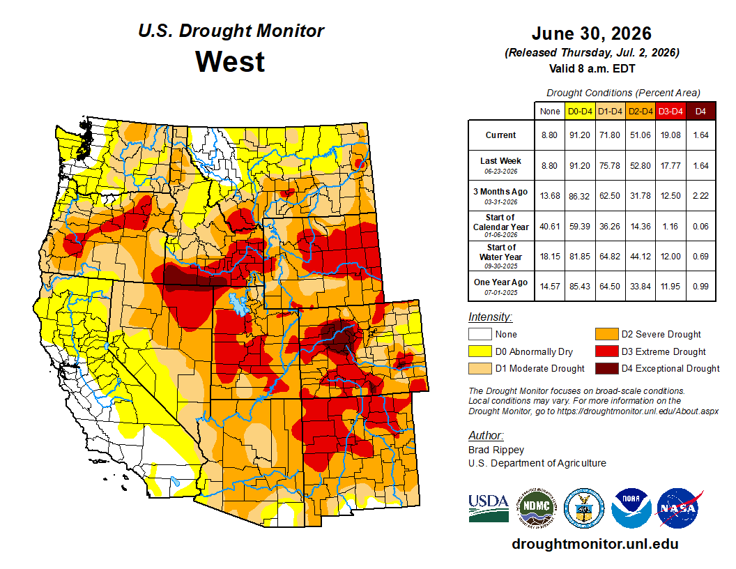
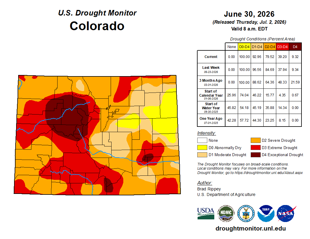
Historic water shortages are drying out the scenic mountains that lie at the heart of Colorado’s tourist economy, prompting the state to issue emergency orders earlier this month allowing water to be shifted to the towns and ranches most likely to run dry.

The Colorado River District, which represents 15 Western Slope counties, is running the emergency response effort and with financial support from the Colorado Water Conservation Board has anted up nearly $1 million to make sure even towns that can’t afford it, will have access to drinking water should it be needed. 

To make the plan work, the river district opted not to lease portions of the water it normally holds in two high country reservoirs, Ruedi in the Roaring Fork Basin and Wolford Mountain, near Kremmling, on a first-come, first-served basis, as it normally does. Instead, the water is being doled out based on community need, with people and food production getting the water first, according to Andy Mueller, manager of the river district.

ā€œWe had a number of requests to lease that water out, but a lot of it would have gone to wealthy gentlemen rancher … but it wouldn’t have been for the common good,ā€ he said.

Under Colorado law, water can only be diverted, stored and used for a designated purpose, such as city drinking water, farm irrigation, environmental streamflows, and industrial uses. Water rights are also tied to seasons, with some available only in the winter or summer.

But this spring, the river district, seeking more flexibility than the laws typically allow, went to Colorado State Engineer Jason Ullmann and asked for emergency authorization to use its water supplies differently. The state agreed, giving the district until the end of August to conduct emergency releases.

At the same time, large agricultural water users in the Grand Valley agreed to cut their water use in an effort to lessen strain on the Colorado River, and protect some of the small towns and ranchers who would have been cut off otherwise.

At issue is a special pool of water that lies within Green Mountain Reservoir, near Heeney, known as the historic users pool, or the HUP. The water is meant as a backup source that allows towns to pump wells and divert from streams even when their water rights are not in priority on the giant mainstem of the Colorado River.

But this year, because of the drought, Green Mountain’s HUP isn’t projected to fill, something that hasn’t occurred since the 1960s when the pool was created to protect mountain water users who had junior water rights, according to Ullmann. The emergency order means that even without the backup from Green Mountain, these communities and ranches will be unlikely to have their water supplies cut off. 

The Eagle River Water and Sanitation District, which serves Vail and other small towns in Eagle County, has water in the HUP. 

Working in the shadow of a nearly snowless winter, the Eagle River District moved early to enact watering restrictions, limiting outdoor use to just two days a week back in April, after March saw temperatures soar to 80 degrees and the patchy snow cover evaporate months earlier than normal.

ā€œThe writing was on the wall,ā€ said Siri Roman, CEO of the Eagle River Water and Sanitation District. ā€œThis is a benefit of being in the headwaters and being a resort,ā€ she said referring to the headwaters of the Colorado River. ā€œOur whole community is so connected to snowpack and snow-water equivalencies and what that means. By February we knew there wasn’t enough snow to change the picture for us. We wanted to get to the decision-makers early and say the red lights are flashing. We need to prepare for a water shortage this summer.ā€

Today a banner sign on its website warns that the risk of water shortages this summer ā€œis very high.ā€

Eagle residents took conservation messages seriously

In Eagle, Tom Gosiorowski, the utilities manager, was standing in Brush Creek shooting videos for the town’s Facebook page, letting its 10,000 water customers know that the stream was the community’s only source of water and it wasn’t looking good. Eagle also relies on the HUP for some of its backup supplies.

ā€œWe are really wholly dependent on the streamflow and the water that is in the creek. It’s different from the big Front Range utilitiesā€ that have reservoirs, he said.

The district is limiting outdoor water use to two days a week and is sharply limiting the filling of hot tubs and swimming pools. Gosiorowski said he expects golf courses to be restricted as well as the summer wears on.

ā€œWe could get to a point where they can only irrigate tees and greens on the golf course,ā€ he said. ā€œWe’ve never had to reduce use, but this is so extreme that I think there will be some.ā€

Gosiorowski said the town was still working on worst-case scenario planning for the end of summer, when streams are normally at their driest. ā€œIt’s hard to know exactly what’s going to happen. We’ve never experienced a drought to this degree in recorded history.ā€

Aspen has also enacted two-day-a-week watering and is prohibiting the filling of pools and hot tubs.

Grand Lake, another community that could be impacted by the shortages at Green Mountain, is not showing signs of strain yet, though officials there are concerned about lake levels.

Grand Lake, the deepest natural lake in Colorado, is linked to two other reservoirs, Shadow Mountain and Lake Granby. All three are part of Northern Water’s Colorado-Big Thompson Project. The C-BT delivers water from the Colorado River to 1 million customers and hundreds of farms on the northern Front Range.

Mike Cassio is a citizen activist who tracks Grand Lake’s health and works with a coalition of community groups and water agencies to help manage the system. Cassio said he’s worried about late summer water levels falling.

ā€œWe know Mother Nature controls everything,ā€ Cassio said. If levels in Lake Granby and Shadow Mountain fall too low, water quality will suffer and that ā€œwill be the biggest issue.ā€

Kathy Chandler-Henry sits on the river district’s board and is a former Eagle County commissioner. She said the brown hillsides and dusty streambeds are unnerving.

ā€œBefore it was never a question,ā€ she said. ā€œThere was always snowfall, there was always water. … Nothing like this year, when it was 80 degrees in March in Vail.ā€

Back in the 1980s, she said she participated in some regional planning efforts to help the Western Slope learn how to manage its growth. That there could be a winter without snow was unthinkable, if not downright funny.

ā€œOne planning consultant in the workshop asked folks what it would be like without snow,ā€ she said. ā€œAnd everyone just laughed.ā€

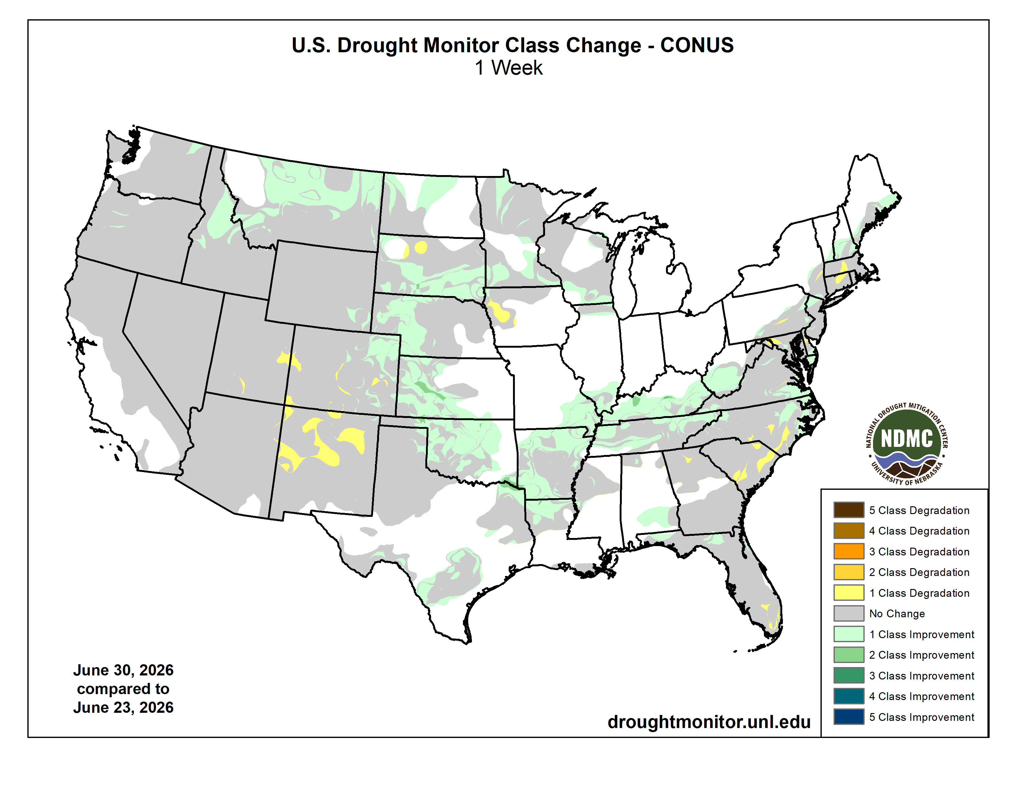
Despite this summer’s deep dry spell, water users say they are encouraged by recent light rains and cool weather. Just weeks ago, the HUP was projected to barely fill at all, but now the 66,000 acre-foot pool is rising again. It recently topped 33,000 acre-feet and is expected to move higher, providing some relief.

But Mueller, of the river district, said this summer is a dress rehearsal for what lies ahead as climate change and warmer temperatures continue to hamper mountain snows and spring stream levels.

ā€œWe are just beginning to grapple with the impacts of climate change. Science indicates that 30 years from now, this year may be on the wetter side.ā€

More by Jerd Smith

Map of the Blue River drainage basin in Colorado, USA. Made using USGS data. By Shannon1 – Own work, CC BY-SA 4.0, https://commons.wikimedia.org/w/index.php?curid=69327693

Shoshone flows: A treasured heirloom for the Western Slope — The #GrandJunction Daily Sentinel #ColordoRiver #COriver #aridification

Shoshone Hydroelectric Plant back in the days before I-70 via Aspen Journalism

Click the link to read the guest column on The Grand Junction Daily Sentinel website (Marc Caitlin). Here’s an excerpt:

July 1, 2026

Last month, leaders from across Colorado’s Western Slope celebrated the release of $40 million in federal funding for the Shoshone Water Rights Preservation Project. At a time when Colorado is celebrating its 150th anniversary and our nation approaches its 250th birthday, this investment represents more than a funding milestone; it marks one of the most significant water preservation achievements our state has seen in generations. It also would not have happened without the determination of our congressional representative, Jeff Hurd, who made this project a priority and worked tirelessly to deliver results for the communities he serves. What Rep. Hurd understands is the same thing that has united more than 100 local, state, and federal elected officials and leaders in support of preserving these critical senior water rights: the future of the Western Slope is inseparable from the future of the Shoshone water rights. Protecting these rights protects the flows of the Colorado River, sustains our agricultural heritage, strengthens our recreation- and tourism-based economies, and helps preserve the rural communities that make this part of Colorado unique…

I believe that 150 years from now, our grandchildren’s grandchildren will look back on the Shoshone Water Rights project as a turning point. They will see a generation of leaders who understood what was at stake and chose to act. They will see communities that put aside differences, came together, and made a long-term investment in the future of the Colorado River. History will remember the Shoshone project as a major milestone in the stewardship of our most precious resources. From Western Slope ditch companies and water conservancy districts to local governments, state leaders, and members of Congress, countless individuals are still working together to turn this vision into reality. The lesson is an important one. On the Western Slope, progress happens when we pull in the same direction. It takes communities working in harness together to move mountains and sometimes to move water. And it takes elected leaders like Jeff Hurd who are willing to put their shoulders into that work. The Shoshone project demonstrates what is possible when rural Colorado speaks with one voice about protecting its water, its economy, and its future.

Western Slope lawmakers take #ColoradoRiver managers to task: Missed deadlines, threat of litigation, conservation program prompt questions — Heather Sackett (AspenJounalism.org) #COriver #aridification

The main boat ramp at Wahweap Marina was unusable due to low water levels in Lake Powell in December 2021. Water levels are projected to soon fall even lower than this at the nation’s second-largest reservoir.Ā CREDIT:Ā HEATHER SACKETT/ASPEN JOURNALISM

Click the link to read the article on the Aspen Journalism website (Heather Sackett):

June 30, 2026

Western Slope lawmakers had harsh words for water managers at a state committee hearing last week, questioning whether Colorado has done enough to avoid a lawsuit with its downstream neighbors.

Colorado Sen. Dylan Roberts, a District 8 Democrat who represents several Western Slope counties, including Eagle, Grand, Garfield, Routt and Summit, asked Colorado’s lead negotiator, Becky Mitchell, whether the people of Colorado should have confidence that negotiations among the seven states that share the Colorado River have put the state in the best possible position. The states have been at an impasse for more than two years without a deal for future management as reservoirs continue to decline to record-low levels.

ā€œMy constituents just see fighting and intransigence,ā€ Roberts said. ā€œAnd it’s concerning to me, especially as a Western Slope lawmaker … that the strategy is just ā€˜Let’s hire more lawyers; we’re going to court no matter what.’ That doesn’t give me confidence, because I don’t think Colorado fares well when we go to court against Arizona and California and Nevada, throwing our fate to the nine justices on the U.S. Supreme Court.ā€

The remarks came at Thursday’s meeting of the state Water Resources and Agriculture Review Committee in Denver. Along with Mitchell, in the hot seat were state engineer Jason Ullmann and Amy Ostdiek, interstate section chief at the Colorado Water Conservation Board. The three are employees of the state Department of Natural Resources and have the backing of the Attorney General’s office in negotiations.

Dylan Roberts, a west slope lawmaker from Colorado. By Jeffrey Beall – Own work, CC BY 4.0, https://commons.wikimedia.org/w/index.php?curid=87044416

Roberts’ line of questioning seemed prompted by recent projections that show river flows dipping below a threshold that could trigger litigation. The Lower Basin states (Arizona, California and Nevada) believe that the Upper Basin states (Colorado, New Mexico, Utah and Wyoming) are bound by the 1922 Colorado River Compact to deliver 82.5 million acre-feet of water over a 10-year rolling average. According to the Upper Colorado River Commission, the 10-year average will dip later this year to about 81.3 million acre-feet because of persistent drought. 

Some experts believe that this amounts to a ā€œtripwireā€ that could trigger a lawsuit from the Lower Basin states (Arizona, in particular, has been openly preparing for litigation) that could result in mandatory cuts in water use for the Upper Basin. Upper Basin water managers don’t subscribe to this interpretation, saying their states are only required not to deplete the river’s flows by more than 75 million acre-feet over 10 years.

Mitchell was reluctant to share details of Colorado’s legal strategy in a public forum, but she answered ā€œabsolutelyā€ that her team’s work was putting Colorado in the best position. She said cutting back prematurely just to satisfy the Lower Basin’s interpretation of the century-old agreement would be bad for the state.

ā€œIf we initiate curtailment now, that is worse for Coloradans,ā€ Mitchell said. ā€œI think that is an important thing to remember.ā€

Wracked by drought, climate change and a management crisis, the situation on the river has never been more dire. The current management guidelines expire this year, and in the absence of a seven-state deal to share shortages and operate the nation’s two largest reservoirs, Lake Powell and Lake Mead, the feds are poised to step in. The U.S. Bureau of Reclamation plans to release a more detailed, short-term plan to manage the river for the next two years by mid-to-late summer.

State Rep. Julie McCluskie, a District 13 Democrat, said communities in her district have been living with the incredible angst, anxiety and pain of no snow and low reservoirs. 

ā€œThe frustration I hear in my community is that we have missed multiple deadlines; they are becoming a funny joke,ā€ McCluskie said. ā€œThere is such a fear about the lengthy litigation process, the fear of an outcome that is far worse for Colorado than a compromise that we have some control over.ā€

Lake Powell is formed by Glen Canyon Dam. In a concept pitched by a conservation organization, a flexible pool of water could be moved between Upper Basin reservoirs to wherever it’s needed most. CREDIT: HEATHER SACKETT/ASPEN JOURNALISM

Conservation conversation is the ā€˜bare minimum’

Lawmakers also had strong words for state officials regarding conservation, saying legislators must be involved in the creation of any program. 

Colorado has dabbled with pilot conservation programs in the past, but traditional programs that pay farmers and ranchers to temporarily cut back on water use remain controversial. This is especially true on the Western Slope, which has long been the target for these types of programs, and where some worry that they could harm rural communities if not done carefully. After two years of exploring how the state could set up a temporary, voluntary and compensated conservation program, officials shelved the idea in favor of focusing on drought-resilience initiatives.

ā€œOther states out of the seven have very clear and actionable roles for their general assemblies, their legislatures,ā€ McCluskie said. ā€œWe have less so, and yet the stakes are so high. So I beg of you, decision-makers, that it is essential that we be a part of those next steps.ā€

Julie McCluskie. Photo credit: Colorado General Assembly

Ostdiek said that any program would need to start slow and make sure it incorporates input from people throughout the state.

ā€œI think that we can continue to assess as we go what we might need from you all, and what a program like that might look like,ā€ Ostdiek said. ā€œI think what we can certainly commit to is continuing this dialogue and continuing the discussion about what we might need to make this a success.ā€

In 2023, Colorado lawmakers tried to force stakeholders to come up with recommendations on conservation programs by creating a statewide task force, which met 10 times over six months. But the group failed to find a consensus, with some saying it was ā€œprematureā€ to create a conservation program.

As part of a post-2026 framework, the Upper Basin states plan to create a ā€œcontributionā€ pool in Lake Powell, which could be used to help stabilize the system, keeping water levels above critical thresholds to protect hydropower at Glen Canyon Dam and acting as an insurance pool against forced cutbacks. In a May 22 letter to federal officials, the Upper Basin states said they have a goal of saving 100,000 acre-feet by the end of water year 2028, but only if sufficient federal funding is available and hydrologic conditions allow.

Three Upper Basin states have different methods for contributing to this pool: Utah has its own demand management program; Wyoming lawmakers passed a law this year allowing for a conservation program; and New Mexico plans to release water from Navajo Reservoir. 

But precisely how — and how much — Colorado would contribute to this pool is unclear. The state’s share of the Upper Basin’s allocation is 51.75%, meaning Colorado could be on the hook for 51,750 acre-feet. 

And ensuring that saved water actually gets into a pool in Lake Powell remains part of the problem. Currently, conserved water that stays in the river can just be picked up by a downstream user, withĀ no net gain to Lake Powell. Colorado officials say they do not have the authority to ā€œshepherdā€ water past other water users to the state line unless it is specifically for compact compliance.Ā [ed. emphasis mine]

Last year, some Delta County ranchers asked lawmakers to take up the issue and pass a law that would address this issue, allowing water users to conserve and get credit for contributing water to a Lake Powell pool. But legislators did not take up a bill in the 2026 session.

Colorado officials told lawmakers they were continuing to explore what a program might look like and whether legislation would be needed.

Roberts said conversations with the legislature should be the bare minimum if Colorado is going to have a conservation program. 

ā€œIf the department or any agency of the state were to pursue a conserved consumptive use program or demand management program that used state tax dollars to pay for it and did not go through the legislature in a formal process, I imagine that all of us on this panel and many of our colleagues would raise holy hell about the unilateral decision-making coming from Denver about programs impacting all parts of the state,ā€ Roberts said. ā€œSo, please, let’s just cut that off at my recommendation. Let’s work together on this.ā€

Officials opened the hearing by highlighting the impacts of this year’s severe drought on Colorado’s farmers and ranchers, noting how even some of the most senior water users will experience shortages as streamflows dwindle. Orchards in the North Fork Valley and row crops in the Uncompahgre River Valley already have unprecedented shortages. 

In response to Roberts’ concerns about the failure to find a compromise among the seven states, Mitchell posed a high-stakes rhetorical question: ā€œI would ask, ā€˜What else do you think we can give?ā€™ā€

The Colorado River Basin spans seven U.S. states and is divided into Upper and Lower Basins. Lake Powell, upstream from the Grand Canyon, and Lake Mead, near Las Vegas, are the two principal reservoirs in the Colorado River water-supply system. (Bureau of Reclamation)

#Drought news July 2, 2026: Pockets of worsening drought were observed in the Four Corners States, including a notable expansion of extreme drought (D3) across the northern half of #NewMexico

Click on a thumbnail graphic to view a gallery of drought data from the US Drought Monitor website.

Click the link to go to the US Drought Monitor website. Here’s an excerpt:

This Week’s Drought Summary

Active weather delivered heavy showers and locally severe thunderstorms east of the Rockies, with a few exceptions. Some of the heaviest rain, locally 4 to 8 inches or more, fell from portions of the central and southern Plains into the Ohio and Tennessee Valleys, leading to pockets of flash flooding and lowland flooding. At least five flood-related fatalities were reported in Kentucky and Tennessee. Exceptions to the wet pattern included the western Gulf Coast region, parts of the Southeast, and an area stretching from the east-central Plains into the lower Great Lakes region. At the start of the drought-monitoring period, hot, dry weather dominated the West. However, a pattern change soon delivered cooler weather across the western U.S., along with widespread Northwestern precipitation. Wet snow blanketed some high-elevation sites in the northern Rockies. During the transition from hot to cool weather, gusty winds and low humidity levels favored wildfire ignition and rapid expansion, especially in portions of the eastern Great Basin and Four Corners States. At the end of June, more than a dozen active Western wildfires had scorched more than 10,000 acres of vegetation apiece, with the largest being the 94,000-acre Cottonwood Fire near Beaver, Utah. On June 28, three federal firefighters perished in the Knowles Fire, west of Grand Junction, Colorado…

High Plains

Like other areas in the central and eastern U.S., a patchwork quilt of showers provided drought relief in some areas. Some of the heaviest rain, occasionally accompanied by thunderstorm-driven high winds and large hail, fell in portions of all six states in the region. However, southeastern Nebraska was one area that missed all the rain. One of the most impressive outbreaks of severe weather occurred on the night of June 28-29, when a swath of wind damage stretched from northwestern Nebraska into southeastern North Dakota and beyond. An unofficial wind gust to 131 mph was clocked in Hyde County, South Dakota, while a gust to 112 mph was recorded at a mesonet station near Ree Heights in Hand County, South Dakota. Despite all the rain, the U.S. Department of Agriculture reported that rangeland and pastures continued to struggle. On June 28, statewide rangeland and pastures were rated 66% very poor in Nebraska, along with 63% in Colorado…

Colorado Drought Monitor one week change map ending June 30, 2026.

West

During the transition from hot weather to cooler conditions, gusty winds fanned recently ignited wildfires across portions of the eastern Great Basin and the Four Corners States. Fire ignition and spread was also abetted by dry thunderstorms, low humidity levels, and near-record to record-setting dry fuels. Pockets of worsening drought were observed in the Four Corners States, including a notable expansion of extreme drought (D3) across the northern half of New Mexico. In the Northwest, however, heavy precipitation—including high-elevation snow—eased drought from central Idaho into western and northern Montana. Less significant precipitation fell in the Pacific Northwest. According to the U.S. Department of Agriculture on June 28, Western States reporting rangeland and pastures rated at least one-half very poor to poor included Arizona (70%) and Colorado (63%), while states with topsoil moisture more than one-half very short to short were Colorado (89%), Wyoming (81%), Utah (69%), New Mexico (68%), Nevada (65%), and Oregon (62%)…

South

The South experienced a second consecutive week of widespread reductions in drought coverage. In fact, flash flooding and lowland flooding plagued some of the hardest-hit areas, including the Arklatex and the southeastern corner of Oklahoma, where 2-week rainfall totals locally exceeded 10 inches. Much of the northern tier of the region, from Oklahoma to Tennessee, also received multiple rounds of heavy rain. Although mostly dry weather prevailed in south-central Texas, some additional improvements were introduced, as impacts of recent downpours on long-term drought became more apparent. By June 28, the U.S. Department of Agriculture indicated that statewide topsoil moisture in agricultural regions was 28% surplus in Louisiana…

Looking Ahead

Hot, humid weather will persist through the Independence Day weekend in most areas along and east of a line from the southern High Plains into the upper Midwest. Some of the most extreme heat will affect the middle Atlantic States, parts of which will experience multiple days with triple-digit (100-degree) heat. Although the Midwest will remain hot, temperatures in most areas will barely reach stressful thresholds (95°F of higher) for corn and soybeans entering the weather-sensitive reproductive stage of development. Furthermore, many Midwestern crops are progressing through the hot spell with adequate to locally surplus soil moisture. Meaningful precipitation during the next 5 days should be limited to parts of Florida’s peninsula and the upper Midwest; both areas could see 1 to 4 inches, with locally higher totals. Other areas of the central and eastern U.S. should receive spotty thunderstorms, while little or no rain will accompany a Western warming trend.

The NWS 6- to 10-day outlook for July 7 – 11 calls for the likelihood of hotter-than-normal weather nationwide, except for near-normal temperatures along and near the Pacific Coast, extending as far south as central California. Meanwhile, odds will be tilted toward near- or above-normal rainfall across most of the country, with drier-than-normal conditions expected to be limited to the Great Basin and environs.

US Drought Monitor one week change map ending June 30, 2026.