🚨 🎬 Colorado River Conference recordings and photos are available. Find a picture of your favorite panelist, audience reaction or candid while mingling. https://t.co/T97wuaVMIY#gwccololaw #gwcwti2026 #ColoradoRiver #ColoradoRiverBasin #waterlaw #waterpolicy pic.twitter.com/PJa7bmQtJg
— Getches-Wilkinson Center @ColoLaw (@CUBoulderGWC) July 8, 2026
Day: July 11, 2026
Northern Water Board Approves Changes to #Colorado-Big Thompson Project Tracking Rule Procedures #ColoradoRiver #SouthPlatteRiver

Click the link to read the release on the Northern Water website:
June 23, 2026
The Northern Water Board of Directors has unanimously approved a change to Colorado-Big Thompson Project accounting procedures concerning C-BT water tracking.
During a rule-making hearing at the June 11 Board meeting, Directors heard about the changes to the rules surrounding the tracking of water from the Project. The new accounting procedures will require accounting of tracking data to be provided in a manner to allow for the administration of C-BT Project water return flows, which will help Northern Water protect them as described in the District’s Repayment Contract with the Bureau of Reclamation, the Water Conservancy Act and contracts with allottees.
The modifications affect only domestic and municipal users, and Northern Water staff met or contacted 26 municipalities, water districts and treatment plants in the months before the rule change was approved.

The July 9, 2026 #ENSO Diagnostic Discussion is hot off the presses from the #Climate Prediction Center #ElNiño

Click the link to read the article on the Climate Prediction Center website:
ENSO Alert System Status: El Niño Advisory
Synopsis: El Niño continues and will strengthen through the end of the year, with a 97% chance it will persist through early spring 2027.
El Niño strengthened over the past month, with a large area of sea surface temperature anomalies in excess of +1.0C across the central and eastern equatorial Pacific. The latest weekly Niño-3.4 index value was +1.2°C, with the westernmost (Niño-4) and easternmost (Niño-1+2) indices at +0.5°C and +2.7°C, respectively. The equatorial subsurface temperature index (average from 180°-100W) increased, as a recent downwelling Kelvin wave deepened the thermocline and raised temperatures in the eastern Pacific. Low-level westerly wind anomalies and upper-level easterly wind anomalies were observed over the western and central equatorial Pacific. Convection was enhanced over the central and east-central equatorial Pacific and was suppressed over Indonesia. The traditional and equatorial Southern Oscillation indices were significantly negative. Collectively, the coupled ocean-atmosphere system reflected a strengthening El Niño.
The North American Multi-Model Ensemble (NMME) average, including the NCEP CFSv2, forecasts El Niño to intensify through 2026. Alongside model forecasts, a strong coupling of the atmospheric and oceanic circulation across the Pacific contributes to very high confidence that El Niño will continue through early 2027. There is an 81% chance of a very strong El Niño during October-December that would rank among the largest El Niño events in the historical record going back to 1950. Even the strongest El Niño events do not lead to the typical impact everywhere, but stronger events can more significantly tilt the odds in favor of expected outcomes (see CPC outlooks for probabilities of seasonal anomalies). In summary, El Niño continues and will strengthen through the end of the year, with a 97% chance it will last through early spring 2027.
Assessing the U.S. Temperature and Precipitation Analysis in June 2026 — NOAA

Click the link to read the article on the NOAA website:
July 9, 2026
Key Takeaways:
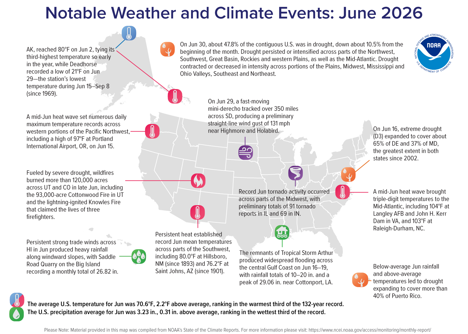
- Widespread June Warmth: The average temperature for the contiguous U.S. (CONUS) in June ranked in the warmest third of the 132-year record, with much of the West, Southwest, Mid-Atlantic and Northeast observing above-average temperatures.
- Hot and Dry Year-to-Date: The West and Southwest climate regions experienced their warmest January–June period on record and received less than 70 percent of their average year-to-date precipitation.
- Midwest Severe Weather: According to NOAA’s Storm Prediction Center, there were 374 preliminary tornado reports during June, with historic activity across the Midwest. Illinois (91 reports), Indiana (69 reports) and Missouri (32 reports) each set new June records.
- Drought Footprint: Drought coverage across the CONUS fell below 50% in June, though drought persisted across much of the interior West and developed in Puerto Rico.
- Hawai’i Precipitation: Following its wettest June since 1997, Hawai’i’s year-to-date precipitation reached a record 54.6 inches—more than two feet above normal.
Other Highlights:
Temperature
The average temperature for the CONUS in June was 70.6°F, 2.2°F above the 20th-century average. Above- to much-above-average temperatures were observed across much of the West, Southwest, southern Plains, Florida, Mid-Atlantic and Northeast. Parts of the northern Rockies and Plains experienced below-average temperatures, while portions of the Midwest and Southeast were near average.

The Southwest climate region tied for its fifth-warmest June on record, averaging 4.9°F above the 20th-century average. Nine states ranked among their 10-warmest Junes on record, including Rhode Island and New Mexico, which each recorded their third-warmest June. Rhode Island also recorded its warmest June average maximum temperature on record, with daytime highs averaging 80.7°F—the first June since 1943 with an average high above 80°F.
Average daytime temperatures were near or below average across much of the South and Gulf Coast, while overnight temperatures were above average. Texas tied its warmest June average minimum temperature at 71.9°F, and neighboring New Mexico and Louisiana each recorded their second-warmest June minimum temperatures. In contrast, several states observed below-average daytime temperatures, including Alabama, where average maximum temperatures were 2.0°F below the 20th-century average.
Alaska’s average temperature was 50.5°F, 1.3°F above the 1925–2000 average, ranking in the warmest third of the 102-year record. Above-average temperatures were observed across southern portions of the Alaska mainland and the Panhandle.
Hawai’i’s average temperature was 68.0°F, 0.3°F above the 1991–2020 average, ranking in the middle third of the 36-year record.Precipitation
Total precipitation averaged across the CONUS in June was 3.23 inches, 0.31 inch above the 20th-century average, ranking in the wettest third of the 132-year record.

Above- to much-above-average precipitation was observed across portions of the far northern tier, central and southern Plains, South, Gulf Coast, Midwest and Great Lakes. Kansas, Illinois, Indiana and Kentucky each ranked among their 10-wettest Junes on record. In contrast, below-average precipitation was observed across parts of the West, Northwest, central and southern Rockies, as well as much of the Florida Peninsula, Carolinas and Mid-Atlantic region.
June precipitation patterns reinforced some of the spatial contrasts observed during the first half of the year, with above-average precipitation across parts of the Midwest and Great Lakes and persistent below-average precipitation across much of the western CONUS and portions of the East Coast. Michigan recorded its wettest January–June on record, 6 inches above average, while Nevada, Arizona, Utah, Wyoming and Colorado received only about half to two-thirds of their average precipitation. Meanwhile, nine East Coast states from South Carolina to Massachusetts ranked among their eight-driest January–June periods on record.
Alaska recorded 1.78 inches of precipitation in June, 0.56 inch below the 1925–2000 average, ranking in the driest third of the 102-year record. Below-average precipitation was observed across portions of the western and southern mainland, the Alaska Peninsula and Aleutians, and the Panhandle.
Hawai’i averaged 7.03 inches of precipitation in June, nearly double the 1991–2020 average of 3.60 inches—its second-wettest June on record. Year-to-date precipitation totaled 54.62 inches, 24.87 inches above average, marking the highest January–June total in the record (1991–present).
Drought
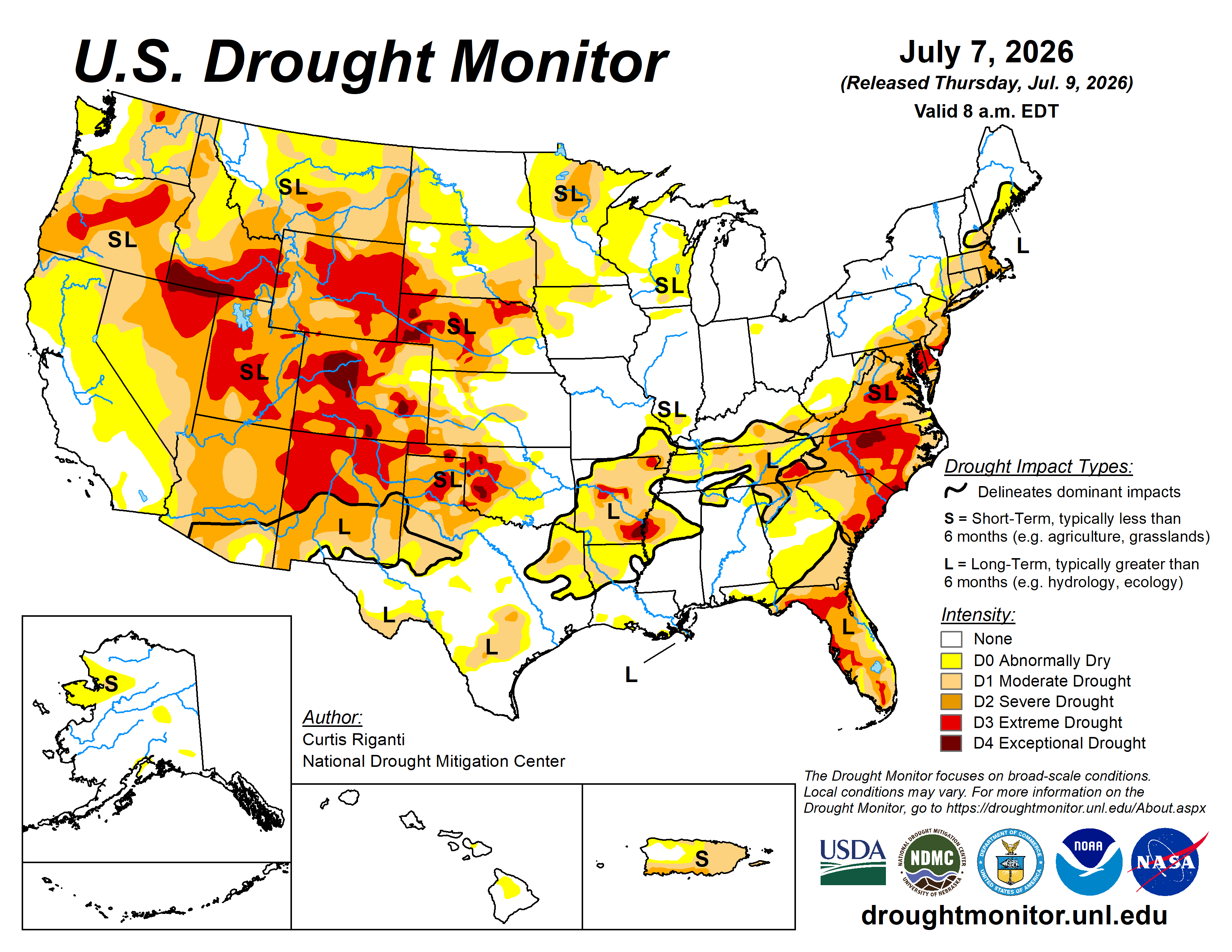
According to the June 30 U.S. Drought Monitor report, about 47.8% of the CONUS was in drought, a decrease of about 10.5% since the beginning of June. Drought persisted or intensified across much of the Northwest, Southwest, Great Basin and Rockies, as well as parts of the western Plains and the Mid-Atlantic from the Carolinas to the Northeast. Drought contracted or decreased in intensity across portions of the Plains, Midwest, lower Mississippi and Ohio Valleys, Southeast and far Northeast. Drought developed across portions of Puerto Rico and the U.S. Virgin Islands.
Monthly Outlook
Above-average July temperatures are favored across the West, South and East, with the greatest likelihood over the Northwest, southern Plains and Southeast. Above-average July precipitation is favored in the Great Basin and parts of the Southwest and Northeast, while below-average precipitation is favored for parts of the Pacific Northwest and western Gulf Coast. Visit the Climate Prediction Center’s Official 30-Day Forecasts for more details.
Drought is expected to persist or expand across much of the Northwest and Rockies, as well as portions of the Plains, Mid-Atlantic and Puerto Rico, while drought improvement or removal is expected for parts of the Southwest and Southeast. Visit the U.S. Monthly Drought Outlook website for more details.
Significant wildland fire potential for July is above normal across much of the Northwest, Great Basin and southern Rockies, as well as parts of the southern Plains, Carolinas, Florida Peninsula and Puerto Rico. For additional information on wildland fire potential, visit the National Interagency Fire Center’s One-Month Wildland Fire Outlook.

Dry fire weather continues, but experts say moisture-laden #monsoon convection may arrive later this month — Shannon Mullane (Fresh Water News)

Click the link to read the article on the Water Education Colorado website (Shannon Mullane):
July 8, 2026
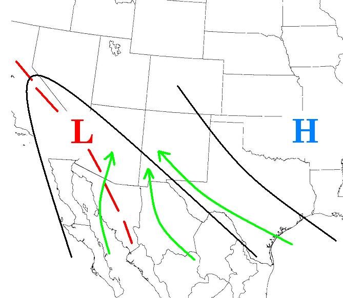
Coloradans can expect some rain this week before high temperatures return over the weekend. After that, experts have high hopes for monsoons to swing into Colorado from the southwest this month — though when exactly that will happen is still up for debate.
Large fires have ignited across the state, killing three firefighters, destroying homes, causing evacuations, and prompting air quality concerns around Colorado. National Weather Service meteorologists were tracking storms this week that dropped moisture on the Western Slope before raising the chance of rain for the Front Range and Eastern Plains. It’s not quite the start of the monsoon season, they said, but the moisture and humidity are offering a short reprieve from the hot, dry and windy conditions that contribute to rapid fire growth.
By this weekend, forecasters are warning of critical fire conditions once again, urging residents and visitors to carefully put out cigarettes, avoid dragging chains from their vehicles and keep a close eye on campfires (where they’re allowed).
“Just do the things to keep everybody safe,” Cameron Simcoe with the National Weather Service in Pueblo said. “Don’t start a wildfire.”
The benefits of this week’s showers in parts of Colorado are likely to dry up over the weekend as a summer heatwave brings triple-digit temperatures to parts of the state. After that, some relief may come this month in the form of monsoonal rains, a weather pattern that brings moisture from the southwest into Colorado. These rains typically arrive in mid-July.
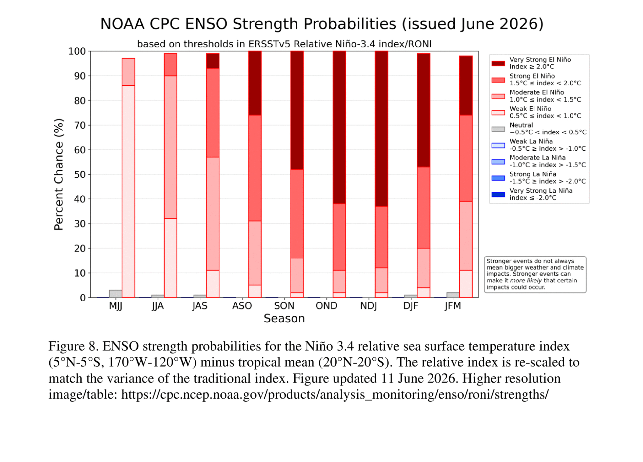
Come fall and winter, Colorado may be able to expect more moisture from a strong El Niño swinging up from the Pacific Ocean. In mid-June, there was a 70% chance that the El Niño would become a “super El Niño,” a rare, strong pattern that impacts weather worldwide, according to climate experts.
“That there will be El Niño by this fall is pretty much guaranteed at this point,” state climatologist Russ Schumacher said. “The chances are better than not that it’ll be pretty strong.”
The Aspen Acres wildfire area is not expected to see critical fire conditions over the next few days, although that could change over the weekend into early next week, he said.
Looking ahead for the north and north-central region
In Boulder, Paul Schlatter, a meteorologist for the NWS Boulder office, does not expect critical fire conditions over the next few days for the north and north-central regions of Colorado, but that will change by Sunday.
“We’re hoping that nobody causes any sparks, especially on Sunday and beyond,” he said.
He is tracking chances for afternoon thunderstorms Wednesday through Friday. By Sunday, temperatures could reach the upper 90s while humidity is expected to hover between 10% and 15%. Wind speeds are likely to be 20 to 25 mph, slightly below the threshold for critical fire conditions. East of Denver, temperatures could reach close to 100 degrees with gusts over 25 mph Monday and Tuesday, Schlatter said.
Coloradans should find ways to stay cool — whether that’s shade, open windows or air-conditioning indoors, he said. Don’t leave pets or children in vehicles, which will reach high temperatures quickly in the summer heatwave.
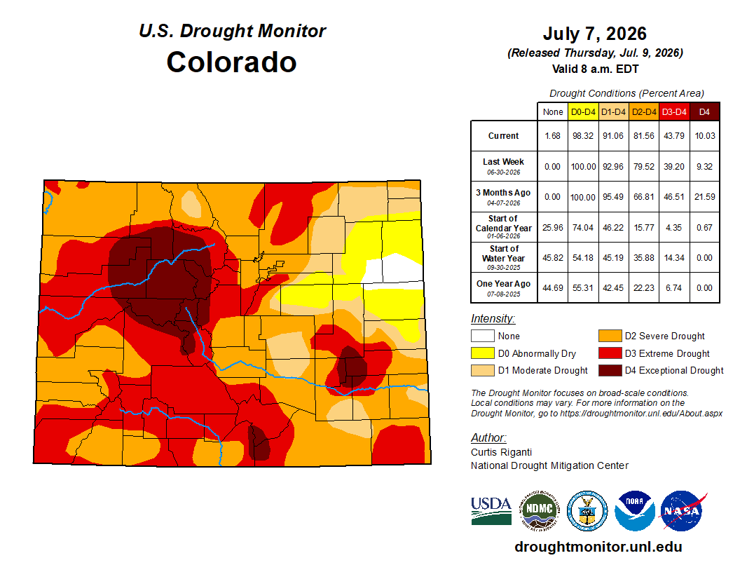
Even with this week’s storms, fuels are primed to burn because of the drought, he said.
About 93% of the state was experiencing drought as of June 30, and 9% was in exceptional drought, the worst of four categories used by the U.S. Drought Monitor. This time last year, about 44% of the state was in drought and no areas were in exceptional drought, according to the Drought Monitor.
“Just the way things have been going around here, it doesn’t take a lot of wind. Because the fuels are so dry, because of the drought, any fire will quickly get going on a day like that,” Schlatter said.
The monsoon is coming — eventually
Colorado’s dry conditions are driven, in large part, by a record-poor snowpack in Colorado’s mountains this winter.
Colorado’s reservoir storage was 64% of the norm as of Tuesday, according to federal data. Its waterways were already struggling by June — typically the driest part of the summer. As of July, some of the major rivers, like the Colorado River which runs through the Western Slope toward Utah, are very likely to have record low flows in total for this water year, which started Oct. 1 and ends Sept. 30, Schumacher said.
The Colorado River, and major tributaries like the Eagle and White rivers, are at or near their record lows for the water year up to this point. For the Gunnison River, only two years have been worse than this year so far out of 100 years of data, he said.
“It’s not surprising to see the flows come down,” Schumacher said. “But they’re coming down from very low peaks and low water levels.”
That makes it hard for prized native, sport and threatened fish to swim through warmer-than-usual waters or make it through shallow areas as they search for refuge in deeper pools. Less water in rivers and streams means less water entering reservoirs and adding moisture to fields that grow food for Colorado and beyond. Some fire officials have worried about strained supplies to fight fires.
With a wet monsoon season, Colorado’s rivers and streams might escape reaching new record lows, Schumacher said.
The forecasts are showing a likelihood that Colorado will receive monsoon rains, which don’t always come to the state in the summer. When they will arrive this year is less certain. They might start within a week or two, on the optimistic side, experts said.
These southwestern storm patterns come with the promise of more humidity in the air, more afternoon clouds and regular chances for rain. How much rain actually falls is unpredictable, but the higher humidity levels should help mitigate fire risk, Schumacher said.
“It’s the days when it’s warm, no humidity, no clouds — those are the days where it’s ripe for fires to grow quickly,” Schumacher said. “When there are chances for rain and it’s cloudy, that all helps. It may not solve the situation, but at least, it moves things in the right direction.”