

Click the link to read the article on the NOAA website:
July 9, 2026
Key Takeaways:
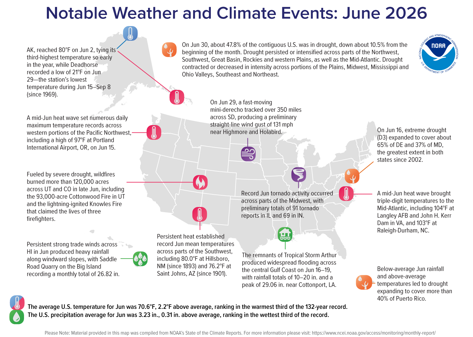
- Widespread June Warmth: The average temperature for the contiguous U.S. (CONUS) in June ranked in the warmest third of the 132-year record, with much of the West, Southwest, Mid-Atlantic and Northeast observing above-average temperatures.
- Hot and Dry Year-to-Date: The West and Southwest climate regions experienced their warmest January–June period on record and received less than 70 percent of their average year-to-date precipitation.
- Midwest Severe Weather: According to NOAA’s Storm Prediction Center, there were 374 preliminary tornado reports during June, with historic activity across the Midwest. Illinois (91 reports), Indiana (69 reports) and Missouri (32 reports) each set new June records.
- Drought Footprint: Drought coverage across the CONUS fell below 50% in June, though drought persisted across much of the interior West and developed in Puerto Rico.
- Hawai’i Precipitation: Following its wettest June since 1997, Hawai’i’s year-to-date precipitation reached a record 54.6 inches—more than two feet above normal.
Other Highlights:
Temperature
The average temperature for the CONUS in June was 70.6°F, 2.2°F above the 20th-century average. Above- to much-above-average temperatures were observed across much of the West, Southwest, southern Plains, Florida, Mid-Atlantic and Northeast. Parts of the northern Rockies and Plains experienced below-average temperatures, while portions of the Midwest and Southeast were near average.

The Southwest climate region tied for its fifth-warmest June on record, averaging 4.9°F above the 20th-century average. Nine states ranked among their 10-warmest Junes on record, including Rhode Island and New Mexico, which each recorded their third-warmest June. Rhode Island also recorded its warmest June average maximum temperature on record, with daytime highs averaging 80.7°F—the first June since 1943 with an average high above 80°F.
Average daytime temperatures were near or below average across much of the South and Gulf Coast, while overnight temperatures were above average. Texas tied its warmest June average minimum temperature at 71.9°F, and neighboring New Mexico and Louisiana each recorded their second-warmest June minimum temperatures. In contrast, several states observed below-average daytime temperatures, including Alabama, where average maximum temperatures were 2.0°F below the 20th-century average.
Alaska’s average temperature was 50.5°F, 1.3°F above the 1925–2000 average, ranking in the warmest third of the 102-year record. Above-average temperatures were observed across southern portions of the Alaska mainland and the Panhandle.
Hawai’i’s average temperature was 68.0°F, 0.3°F above the 1991–2020 average, ranking in the middle third of the 36-year record.Precipitation
Total precipitation averaged across the CONUS in June was 3.23 inches, 0.31 inch above the 20th-century average, ranking in the wettest third of the 132-year record.

Above- to much-above-average precipitation was observed across portions of the far northern tier, central and southern Plains, South, Gulf Coast, Midwest and Great Lakes. Kansas, Illinois, Indiana and Kentucky each ranked among their 10-wettest Junes on record. In contrast, below-average precipitation was observed across parts of the West, Northwest, central and southern Rockies, as well as much of the Florida Peninsula, Carolinas and Mid-Atlantic region.
June precipitation patterns reinforced some of the spatial contrasts observed during the first half of the year, with above-average precipitation across parts of the Midwest and Great Lakes and persistent below-average precipitation across much of the western CONUS and portions of the East Coast. Michigan recorded its wettest January–June on record, 6 inches above average, while Nevada, Arizona, Utah, Wyoming and Colorado received only about half to two-thirds of their average precipitation. Meanwhile, nine East Coast states from South Carolina to Massachusetts ranked among their eight-driest January–June periods on record.
Alaska recorded 1.78 inches of precipitation in June, 0.56 inch below the 1925–2000 average, ranking in the driest third of the 102-year record. Below-average precipitation was observed across portions of the western and southern mainland, the Alaska Peninsula and Aleutians, and the Panhandle.
Hawai’i averaged 7.03 inches of precipitation in June, nearly double the 1991–2020 average of 3.60 inches—its second-wettest June on record. Year-to-date precipitation totaled 54.62 inches, 24.87 inches above average, marking the highest January–June total in the record (1991–present).
Drought
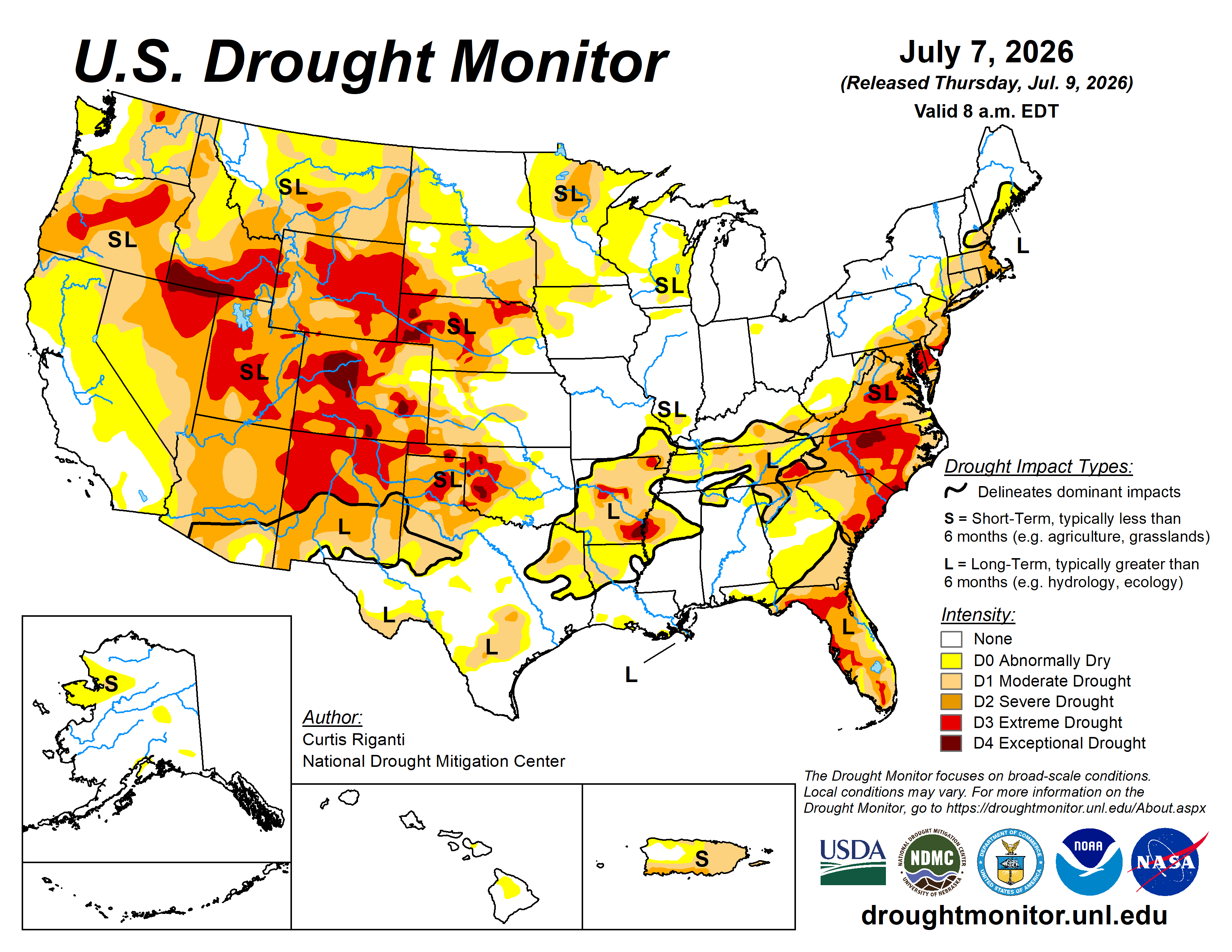
According to the June 30 U.S. Drought Monitor report, about 47.8% of the CONUS was in drought, a decrease of about 10.5% since the beginning of June. Drought persisted or intensified across much of the Northwest, Southwest, Great Basin and Rockies, as well as parts of the western Plains and the Mid-Atlantic from the Carolinas to the Northeast. Drought contracted or decreased in intensity across portions of the Plains, Midwest, lower Mississippi and Ohio Valleys, Southeast and far Northeast. Drought developed across portions of Puerto Rico and the U.S. Virgin Islands.
Monthly Outlook
Above-average July temperatures are favored across the West, South and East, with the greatest likelihood over the Northwest, southern Plains and Southeast. Above-average July precipitation is favored in the Great Basin and parts of the Southwest and Northeast, while below-average precipitation is favored for parts of the Pacific Northwest and western Gulf Coast. Visit the Climate Prediction Center’s Official 30-Day Forecasts for more details.
Drought is expected to persist or expand across much of the Northwest and Rockies, as well as portions of the Plains, Mid-Atlantic and Puerto Rico, while drought improvement or removal is expected for parts of the Southwest and Southeast. Visit the U.S. Monthly Drought Outlook website for more details.
Significant wildland fire potential for July is above normal across much of the Northwest, Great Basin and southern Rockies, as well as parts of the southern Plains, Carolinas, Florida Peninsula and Puerto Rico. For additional information on wildland fire potential, visit the National Interagency Fire Center’s One-Month Wildland Fire Outlook.
