Denver Water’s Gross Reservoir Expansion Project reached a milestone in June as workers completed major construction on raising the dam.
On June 3, 2026, workers placed the final load of roller-compacted concrete on the top of the dam, bringing Gross Dam to a height of 470 feet. Roller-compacted concrete is the type of concrete put in place to raise, thicken and lengthen the dam over the past three years.
The project is designed to nearly triple the capacity of Gross Reservoir, increase Denver Water’s reservoir storage capacity by 11%, and provide balance, resiliency and flexibility to the utility’s water collection system.
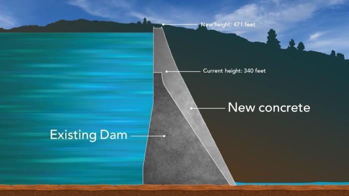
Additional work to complete the dam will take place over the next year, including adding one more foot of conventional, protective concrete to the top of the dam, which will bring it to its final height of 471 feet above the valley floor below.
At this point, dam is taller and also has a new shape.
“We have fundamentally changed how this dam works. The old Gross Dam was a gravity dam that held back the water by its sheer weight. We’ve now transformed this into an arch dam which holds the water back by its weight and also transfers the loads laterally like a Roman arch. This is the first time that we know that this dam transformation has ever been done in the world.”
Gross Dam on June 2, 2026, on the final day of roller-compacted concrete placement work. Photo credit: Denver Water.
In the video above, you can see new images of the dam and hear from Jeff Martin, Denver Water’s program manager for the project.
“We’re excited and proud of this accomplishment,” Martin said.
“Hundreds of people helped us reach this milestone, which will provide a secure water future to Denver and the surrounding communities.”
Roller-compacted concrete will be placed on top of the existing dam to raise it to a new height of 471 feet. A total of 118 new steps will make up the new dam. Image credit: Denver Water.
Click the link to read the release on the USDA website:
July 24, 2026
USDA is investing $3 million to support the development of wetland mitigation banks for agricultural producers. through the Wetland Mitigation Banking Program (WMBP).
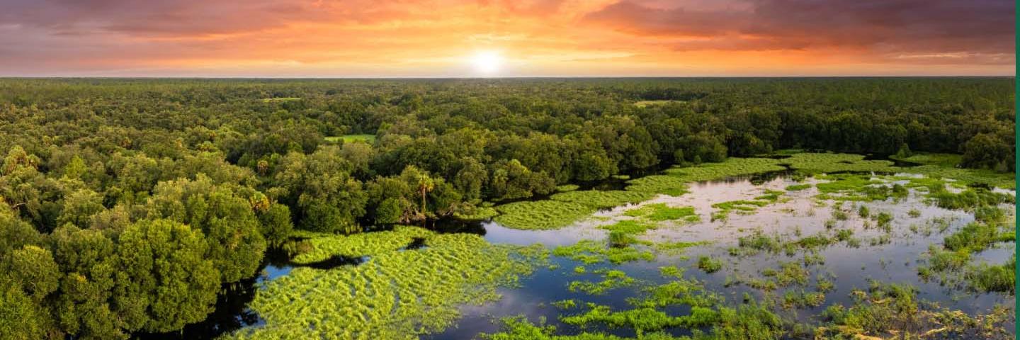
The U.S. Department of Agriculture (USDA) is investing $3 million to support the development of wetland mitigation banks for agricultural producers. Through the USDA’s Wetland Mitigation Banking Program (WMBP), wetlands are restored, created or enhanced, generating credits that can be purchased by producers looking to compensate for unavoidable impacts to wetlands at another location.
“Wetland mitigation banks provide farmers and ranchers a clear and efficient compliance pathway, while at the same time helping to restore and protect vital wetlands and all the benefits they provide,” said USDA’s Natural Resources Conservation Service (NRCS) Chief Colton L. Buckley. “Through the Wetland Mitigation Banking Program, we can help ensure the long-term resilience and productivity of American working landscapes.”
WMBP awardees work with NRCS to develop a mitigation banking instrument that provides details for developing, establishing and operating a mitigation banking program. Priority will be given to banks in states with significant numbers of individual wetlands, wetland acres and conservation compliance requests. Based on NRCS data, these states are Georgia, Illinois, Indiana, Iowa, Michigan, Minnesota, Nebraska, Ohio, Pennsylvania, South Dakota and Wisconsin.
City and county governments, organizations, tribal governments and other entities are eligible to apply. See the notice of funding on Grants.gov for a full list of eligible entity types.
Applications are due by September 8, 2026. Visit the Grants.gov opportunity for additional details and to apply.
More About WMBP
To participate in most USDA programs, agricultural producers agree to comply with the wetland conservation provisions, meaning producers will not plant agricultural commodities on converted wetlands or convert wetlands to enable agricultural production. In situations where avoidance or on-site mitigation is challenging, the Farm Bill allows for off-site mitigation through the purchase of mitigation banking credits.
Purchasing credits from a wetland mitigation bank provides a legal mechanism for agricultural producers to maintain their eligibility for USDA program benefits if they convert agricultural wetlands.
WMBP award recipients can use the funding to support the costs of developing and establishing a mitigation bank, like costs for site identification, development of a mitigation banking instrument, site restoration, land surveys, permitting and title searches, and market research. WMBP funding cannot be used to purchase land or a conservation easement.
NRCS awarded the first WMBP grants in 2016. Since then, NRCS has awarded 39 projects supporting the creation or expansion of wetland mitigation banks in 14 states.
Awardees can request up to $1 million for a project. Projects may last up to four years.
When a mitigation bank is established, the landowner retains ownership and use of the property, while a conservation easement protects the wetlands from incompatible degrading activities.
To learn more about the Wetland Mitigation Banking Program, and how wetland mitigation banks work, visit the WMBP webpage.
For more than 90 years, NRCS has helped farmers, ranchers and forestland owners make investments in their operations and local communities to improve the quality of our air, water, soil, and wildlife habitat. NRCS uses the latest science and technology to help keep working lands working, boost agricultural economies, and increase the competitiveness of American agriculture. NRCS provides one-on-one, technical advice and financial assistance and works with producers to help them reach their goals through voluntary, incentive-based conservation programs. For more information, visit nrcs.usda.gov.
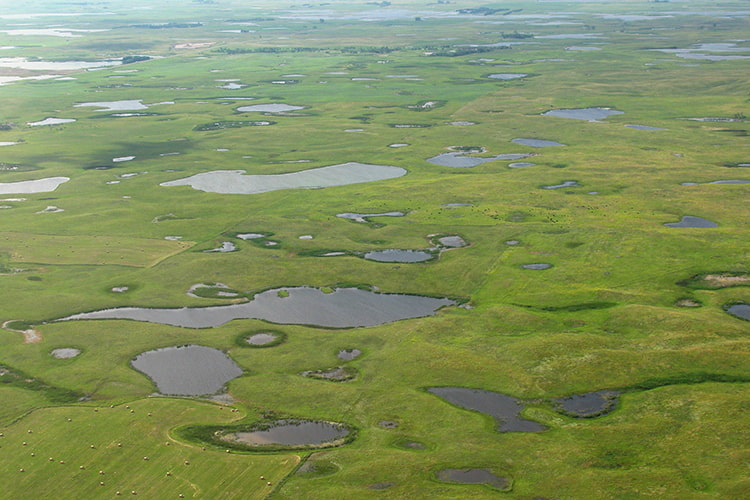
Wetlands, like these in the Prairie-Pothole Region of North Dakota, may capture and store nutrient runoff from cropland fields. Photo Credit: U.S. Fish and Wildlife Service
The Northern Colorado Water Conservancy District (Northern Water), the U.S. Bureau of Reclamation, Grand County, the Northwest Colorado Council of Governments (NWCCOG), the Colorado River Water Conservation District (Colorado River District) and the Town of Grand Lake today announced a landmark agreement establishing the Three Lakes CLEAR Initiative, a long-term effort to improve water clarity, watershed health and resilience across Grand Lake, Shadow Mountain Reservoir and Granby Reservoir (the Three Lakes).
The Three Lakes System is part of the federal Colorado-Big Thompson (C-BT) Project, which collects and stores water in Grand County and then diverts it for use by C-BT beneficiaries on the Front Range through a series of reservoirs, ditches and tunnels. The CLEAR Initiative continues the ongoing Grand Lake Adaptive Management framework for managing C-BT Project operations and incorporates additional collaborative initiatives to enhance clarity and provide watershed health benefits within and upstream of the Three Lakes System.
CLEAR stands for Clarity, Legacy, Ecosystem, Adaptation and Resilience, reflecting the shared commitment by partners to protect and improve this important resource.
The agreement marks a major milestone following two decades of coordinated work to improve clarity in Grand Lake and water quality in Shadow Mountain Reservoir and reflects a renewed commitment to sustained action and investment. It also provides a long-term framework to continue and expand this work as the Grand Lake Clarity Stakeholders’ Memorandum of Understanding (MOU), established in 2016, expires in December 2026. Today’s action renews and expands upon that MOU, protecting the Three Lakes and tributary watersheds for the next 30 years.
As part of the agreement, Northern Water, the Northern Colorado Water Conservancy District Municipal Subdistrict, and the Windy Gap Firming Project Water Activity Enterprise will provide $30 million over 30 years to address both C-BT Project operations and the broader environmental conditions influencing water quality by supporting implementation of projects and initiatives that address watershed and lake conditions. Of that amount, $20 million will be directed toward project funding to accelerate near-term, priority on-the-ground improvements initiatives, while $10 million will build a long-term reserve fund intended to provide sustained, legacy funding and the flexibility to address future needs as conditions evolve beyond the 30-year agreement.
The initiative continues and strengthens the collaborative adaptive management of C-BT Project operations in the Three Lakes that began with the original MOU, using real-time adjustments to improve clarity in Grand Lake while balancing water supply, power generation and environmental needs. At the same time, the initiative establishes a dedicated fund directed by the parties, to invest in watershed and system health projects that improve water quality and ecological conditions across the Three Lakes system and tributary watersheds.
Projects will focus broadly on watershed and forest health, reducing sediment and nutrient inputs, improving lake and reservoir conditions, and strengthening monitoring and adaptive management tools across the interconnected system.
“The foundation for this landmark agreement to improve Grand Lake clarity and create the Three Lakes CLEAR Fund was laid over decades of effort by many, representing all parties, to improve and use our knowledge of the Three Lakes System for actionable projects that can move the needle for better Grand Lake clarity. The parties have differing interests for sure, but we strive to find common ground because we have a spirit of mutual trust and respect,” said Jeff Metzger, Town of Grand Lake.
Northern Water emphasized the enduring framework the agreement creates to support the long-term health and resilience of the Three Lakes System while benefiting communities on both sides of the Continental Divide.
“The Three Lakes CLEAR Initiative demonstrates how shared stewardship of Grand Lake clarity and the health of the broader Three Lakes System and its watersheds can strengthen the long-term resilience of the Colorado-Big Thompson Project for the benefit of Front Range water users while supporting the natural resources and thriving West Slope communities that depend on them. By creating a lasting legacy of collaboration and investment, this agreement helps ensure these shared resources will continue to be protected for generations to come,” said Esther Vincent, Environmental Services Director for Northern Water.
Grand County Board of County Commissioners Chair Edward Raegner highlighted the importance of the agreement for Grand County and the local communities that have stewarded the Three Lakes watershed for generations.
“This 30-year MOU reflects an unprecedented commitment to Grand Lake’s health and the long-term future of the Three Lakes System. Grand County is proud to work alongside our partners to help preserve Grand Lake’s water clarity for generations to come.”
The Colorado River District emphasized the value of continuing the collaborative approach that has guided clarity improvements in the Three Lakes System for the past decade.
“This MOU continues the collaborative approach that has guided clarity work in Grand Lake and water quality throughout the Three Lakes system since 2016. Over the past decade, we’ve gained valuable knowledge about how to effectively use adaptive management in the system, and this agreement will provide a strong foundation to continue that work for the long term. As a signatory to this MOU, the Colorado River District will continue to be a voice for the Western Slope and advocate for solutions that protect our water resources and the communities which depend on them,” said Rebecca Briesmoore, Senior Water Resources Engineer with the Colorado River District.
Former NWCCOG Executive Director Jon Stavney also welcomed the long-term commitment.
“Since the 1970s, our organization has been engaged in multiple efforts to protect and enhance the water quality of Grand Lake. This MOU represents a new beginning backed by a long-term commitment of substantial resources to the clarity of Grand Lake.”
Colorado-Big Thompson Project map. Courtesy of Northern Water.
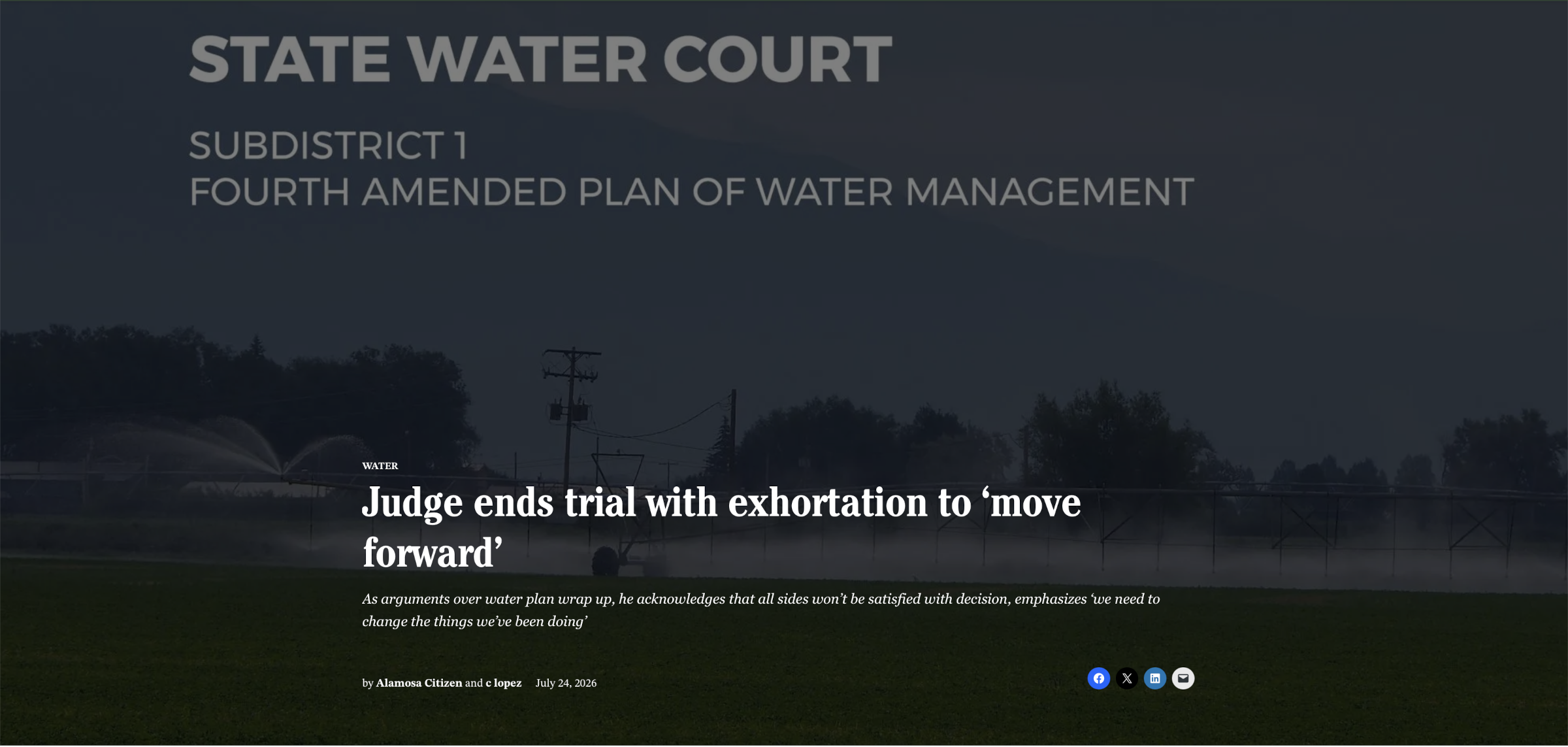
The different sides each presented closing arguments, but it was the reflections of Division 3 Water Court Judge Michael Gonzales that had the courtroom thinking as he brought to a close the water trial dealing with the Subdistrict 1 Fourth Amended Plan of Water Management.
At times it was a bruising trial Gonzales noted Thursday in his closing remarks, as he encouraged all the parties to move on and to not let the four-week trial wear on them and their own personal relationships.
“We all know that there’s no way this court can fashion an order or an opinion that’s going to satisfy everybody. It’s just not going to happen,” the judge said. “I mean, it can’t because we know that we have mutually exclusive and competing interests. We know that this petition when it was created recognized that, but we still said ‘cooperation’ and all those nice things. And in reality, I think we all knew at some point that was going to come to a head. And I think we’re there, but that doesn’t mean we still don’t move forward.”
San Luis Valley Groundwater
This was the big water trial because it dealt with a plan to recover the unconfined aquifer of the Upper Rio Grande Basin, Gonzales noted. He pointed to testimony of Mosca-area farmer Lyle Nissen as one he enjoyed the most.
“I just loved his testimony. Someone who’s made some recognition, someone who’s made some changes, someone who didn’t come in here and complain and just said, ‘This is how it is. I recognize it and I move forward.’ And that was great to hear,” Gonzales said.
He also referenced a term he learned during the course of the trial, “deep percolation,” and used it to provide further insight into his thinking.
“I sat in my back yard and I watched the rain come down,” he said of the week’s weather. “I watched puddles form and I thought about my second favorite term from this trial, ‘deep percolation’ and I said, ‘Aha.’ And then I came back 10 minutes later and that puddle was completely gone. I said, ‘Wow.’
“I also sat there and I thought about the testimony I think was from this current state engineer when he said that we need rainstorms of biblical proportion to get us where we need to be, and that hit home. And no matter how wonderful that rain was, there needs to be things that happen.”
The state Division of Water Resources and the Rio Grande Water Conservation District are asking Gonzales to reject the protestors’ arguments and approve the plan. Without it, they argued, the unconfined aquifer won’t recover and broad groundwater well curtailment in the subdistrict becomes inevitable.
The cornerstone of the new plan is the “one-for-one” feature, which limits groundwater pumping to the amount of natural surface water that flows into the subdistrict over a five-year running average. The intent is to put more water into the unconfined aquifer system than is taken out and one-for-one pumping guarantees that, according to the state and subdistrict.
Gonzales noted “the monstrosity of an equation” within the Fourth Amended Plan when he was quizzing Rio Grande Water Conservation District attorney Pete Ampe during his closing remarks.
The one-for-one pumping feature, the equation to determine success, and a new “depletion fee” that sets the value of water in the subdistrict at $500 per acre-foot were all argued over, discussed and debated throughout the month-long trial.
Attorney Mirko Kruse, representing his family’s farming interest, and attorney Andy Jones, representing L Cross Ranch, want Gonzales to refer the plan back to the subdistrict for adjustments they’re requesting but are otherwise good with the plan.
Two other protesting groups, Northeast Water Users Association and Sustainable Water Augmentation Group, want the plan tossed entirely on grounds it isn’t legal; they asked Gonzales to order the subdistrict to only make changes to the existing third plan of water management.
Gonzales told all the attorneys to address Rule 8.7 of the state groundwater rules governing the Upper Rio Grande Basin. That rule determines how “proportional responsibility for maintaining a sustainable water supply is divided among all the well users within the Response Area.”
It gets to one of the key arguments made by SWAG and its belief that groundwater irrigators like their clients are being illegally targeted and asked to share a disproportionate share of the burden in the unconfined aquifer recovery efforts.
Gonzales provided a timeline that leads to this Thanksgiving for when all the case documents and filings will be completed and he can begin his deliberations.
“I guess if there’s one message that we all need to take to heart is that we need to change the things we’ve been doing,” Gonzales said in completing his comments. “We can’t continue down the path we’ve been because if we think that’s the only way we can go, we’re dooming our children, our children’s children. And I don’t want to be a part of that time.”
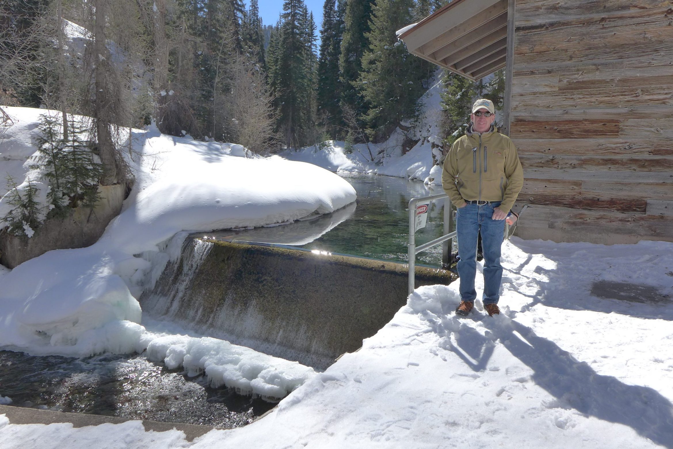
Aspen Utilities Resource Manager Steve Hunter stands at the city’s Castle Creek water diversion in this February 2021. CREDIT: HEATHER SACKETT/ASPEN JOURNALISM
The city of Aspen Drought Response Committee is recommending to continue the current Stage Three Water Shortage Declaration amid persisting drought conditions and an approximately 75% compliance with Stage Three Water Shortage Restrictions. The Drought Response Committee meets monthly in order to discuss current conditions and assess what level of restrictions are necessary to meet demand for essential uses. According to an information update provided to Aspen City Council prior to their Monday meeting, the latest drought data for Aspen and the Roaring Fork watershed necessitate the continuation of the current Stage Three Water Shortage Declaration and Restrictions. Aspen’s municipal water supply comes from Castle and Maroon Creeks, and the Aspen water system relies primarily on direct streamflow through the consistent release of water from snowmelt throughout the year. The information update confirms that, during drier than normal years, the city’s water policy enables council to enact its Water Shortage Ordinance by selecting an appropriate water shortage stage. A Stage Two Water Shortage went into effect Sept. 1, 2025, and was elevated to a Stage Three Water Shortage declaration on May 12, effective May 15…
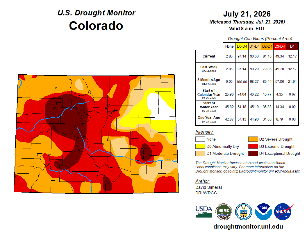
Colorado Drought Monitor map July 21, 2026.
“Since the Stage Three declaration was made in May, drought conditions have remained throughout the Roaring Fork Watershed,” the update reads.
It confirms that the July 16 U.S. Drought Monitor continues to show Aspen and Pitkin County fully in the Exceptional Drought — D4 — Category, the highest level of drought. Stream flow in June in the Roaring Fork watershed was at 27% of normal, and the Maroon Creek stream gauge measured peak runoff on June 7 at 143 cubic feet per second; the historical average peak runoff occurs between June 15-30 at over 300 cfs.
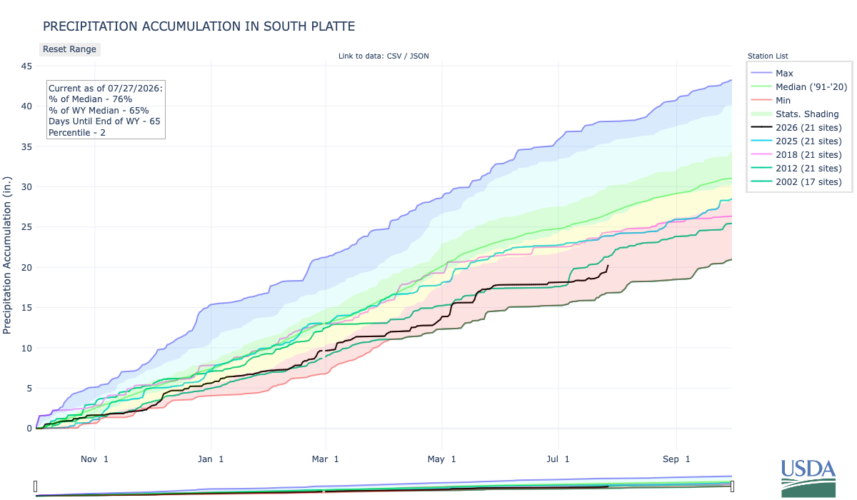
Below is the Precipitation Accumulation in South Platte graph from the NRCS for July 27, 2026. This morning precipitation is at 76% of the median (up 4% one week), and 65% of the water year median (up 5% one week). There are 65 days left in the water year.
Thunderstorrms are likely today through Wednesday, there is a chance for thunderstorms Thursday, a slight chance for thunderstorms Friday, with a chance for showers/thunderstorms Saturday and Sunday, in the central mountains. Light rain is currently falling and thunderstorms are likely today, there is a slight chance for showers then thunderstorms are likely Tuesday and Wednesday, with a chance for thunderstorms Thursday and Friday, and a slight chance for showers/thunderstorms Friday and Saturday in the northern mountains. There is a chance for thunderstorms today, thunderstorms are likely Tuesday and Wednesday, with a slight chance for thunderstorms Thursday and Friday, and a slight chance for showers/thunderstorms Sunday, down here, about 12 miles from Golden, where the Colorado Central Railroad was chartered February 9, 1865. From Wikipedia:
The railroad was chartered as the Colorado and Clear Creek Railroad Company on February 9, 1865, by Loveland and other entrepreneurs in the town of Golden, then the capital of the Colorado Territory. Loveland and his partners desired to build a 4 ft 8+1⁄2 in (1,435 mm) standard gauge railroad up Clear Creek Canyon to Central City and other mining centers, and to connect to nearby Denver and Boulder. During the three years before construction on the line began the company underwent several reorganizations. On January 20, 1866, the name of the railroad was changed to the Colorado Central & Pacific Railroad. The following year, in June 1867, the company was reorganized; Union Pacific investors were in control, but provided no funds for construction. That year, the seat of territorial government for Colorado was relocated from Golden to Denver…In May 1871 local interests regained control of the railroad from Union Pacific investors. By the following September, 150 men were at work in the mountains west of Golden to extend the line to the mining communities. In the spring of 1872 the company acquired critical right-of-way along Clear Creek to extend its line. West of Golden, the line built as 3 ft (914 mm) narrow gauge. In late August, the company took delivery of its first two locomotives (both 0-4-0T), the General Sherman, No. 2, followed a week later by General Sheridan, No. 1. On September 1, the track was completed 13.3 miles to Forks Creek. By mid-December, the line had been extended 7.7 miles further to Black Hawk. By February 24, 1873, a second line from Forks Creek had been extended 3.3 miles to Floyd Hill. In September, the company’s shop in Golden produced the first passenger car in Colorado. On May 11, 1874, the company took delivery of an 18-ton Mogul locomotive from Dawson & Baily. The new locomotive replaced the “Sheridan” as the #1 locomotive.
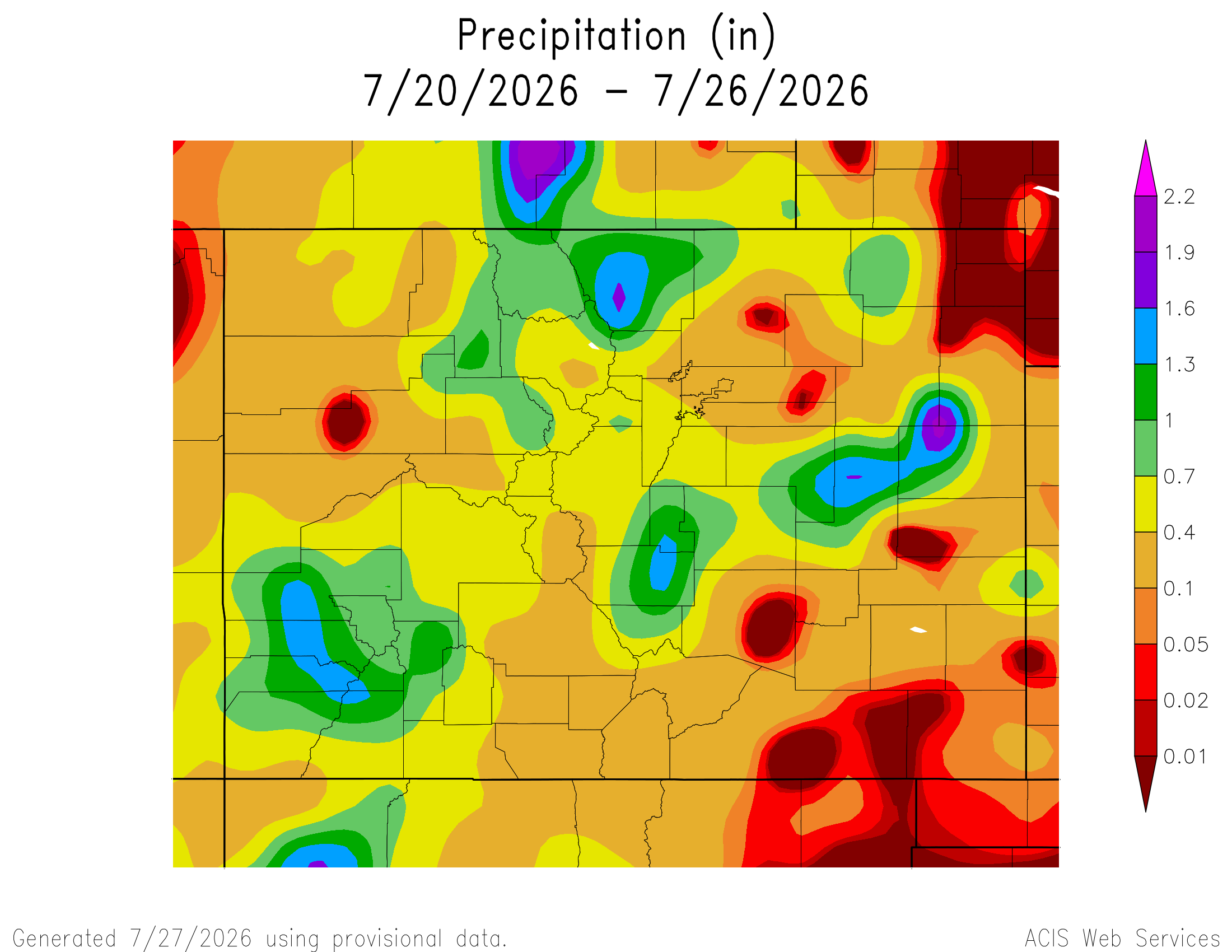
Here’s a look at the 7-Day Colorado precipitation map through July 26, 2026 from the High Plains Regional Climate Center. Precipitation in the South Platte Basin along the Continental Divide of the Americas ranged from 0.10” to 1.90”.
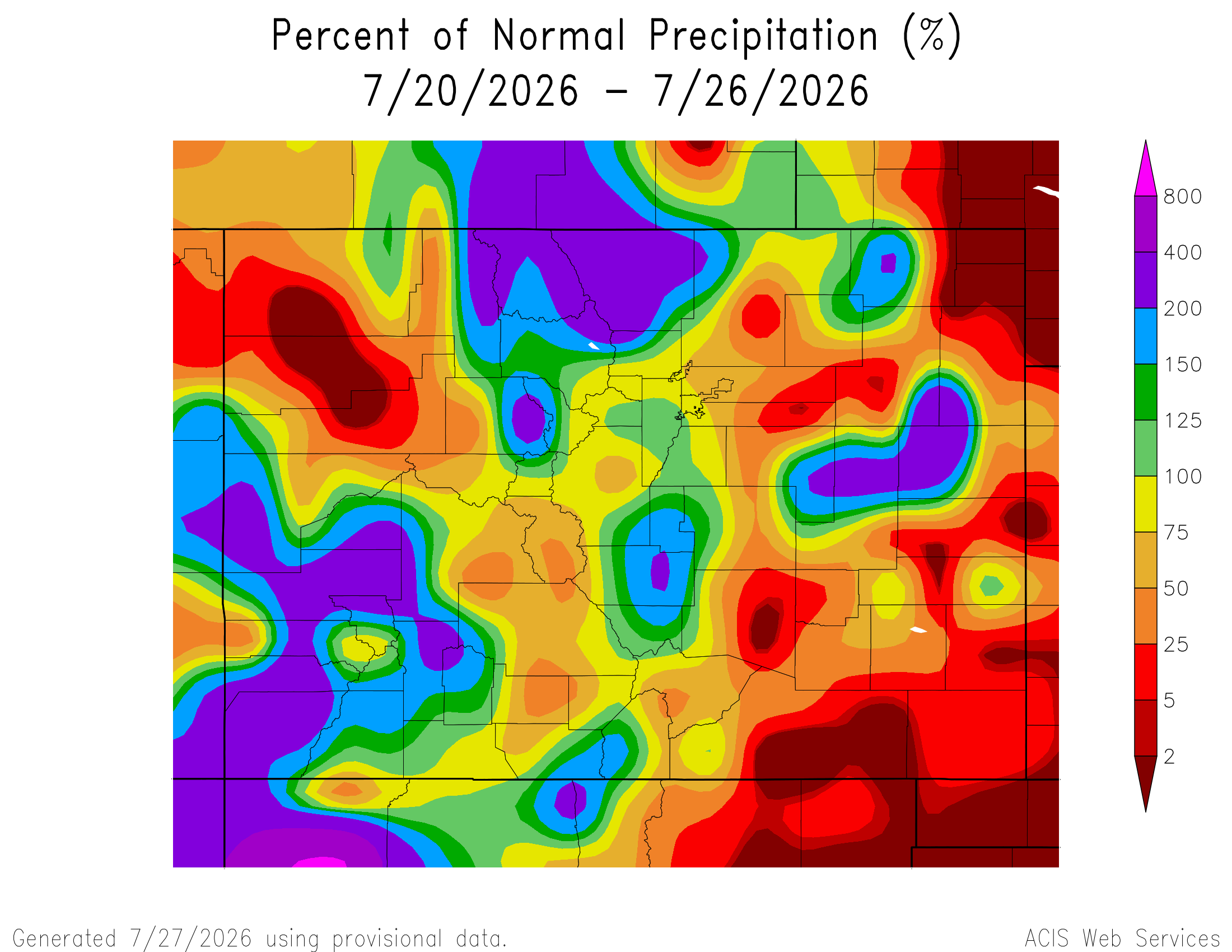
Here’s the 7-Day percent of normal precipitation map through July 26, 2026 from the High Plains Regional Climate Center. Precipitation in the South Platte River Basin along the Continental Divide of the Americas ranged from 50% to 400% of normal.
Below is the 7-day Quantitative Precipitation Forecast for the week of July 27, 2026. Precipitation is anticipated for the mountains of the South Platte River Basin and may total up to 1.50″.
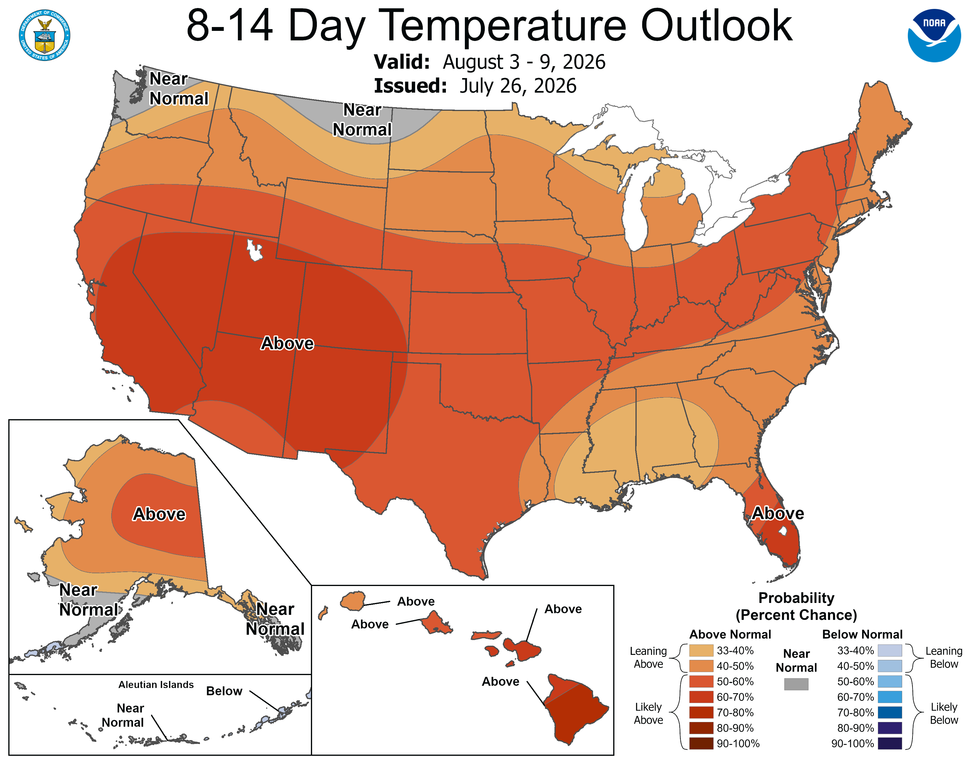
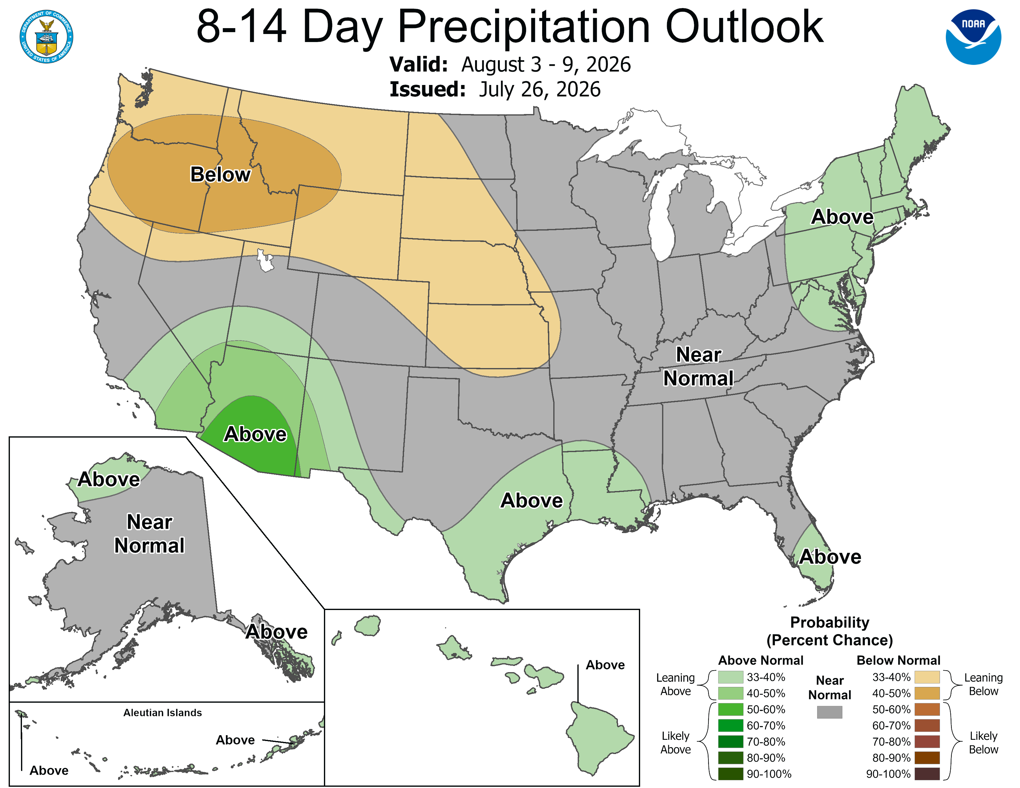
Below are the 8-14 day outlooks from the Climate Prediction Center, issued July 26, 2026, for temperature and precipitation, for the week starting July 27, 2026. The CPC expects above normal temperatures and near normal to below normal precipitation for the mountains of the South Platte River Basin.
Below is the Colorado Drought Monitor map from June 21, 2026. There were one class degradations in Douglas, Elbert, Arapahoe, Adams, Denver, Jefferson, Clear Creek, Gilpin, Boulder, Weld, Morgan, and Larimer counties, in the South Platte River Basin. Drought and abnormal dryness covers 97.14% of Colorado. The South Platte Basin is experiencing Abnormally Dry, Moderate, Severe, Extreme, and Exceptional drought conditions.
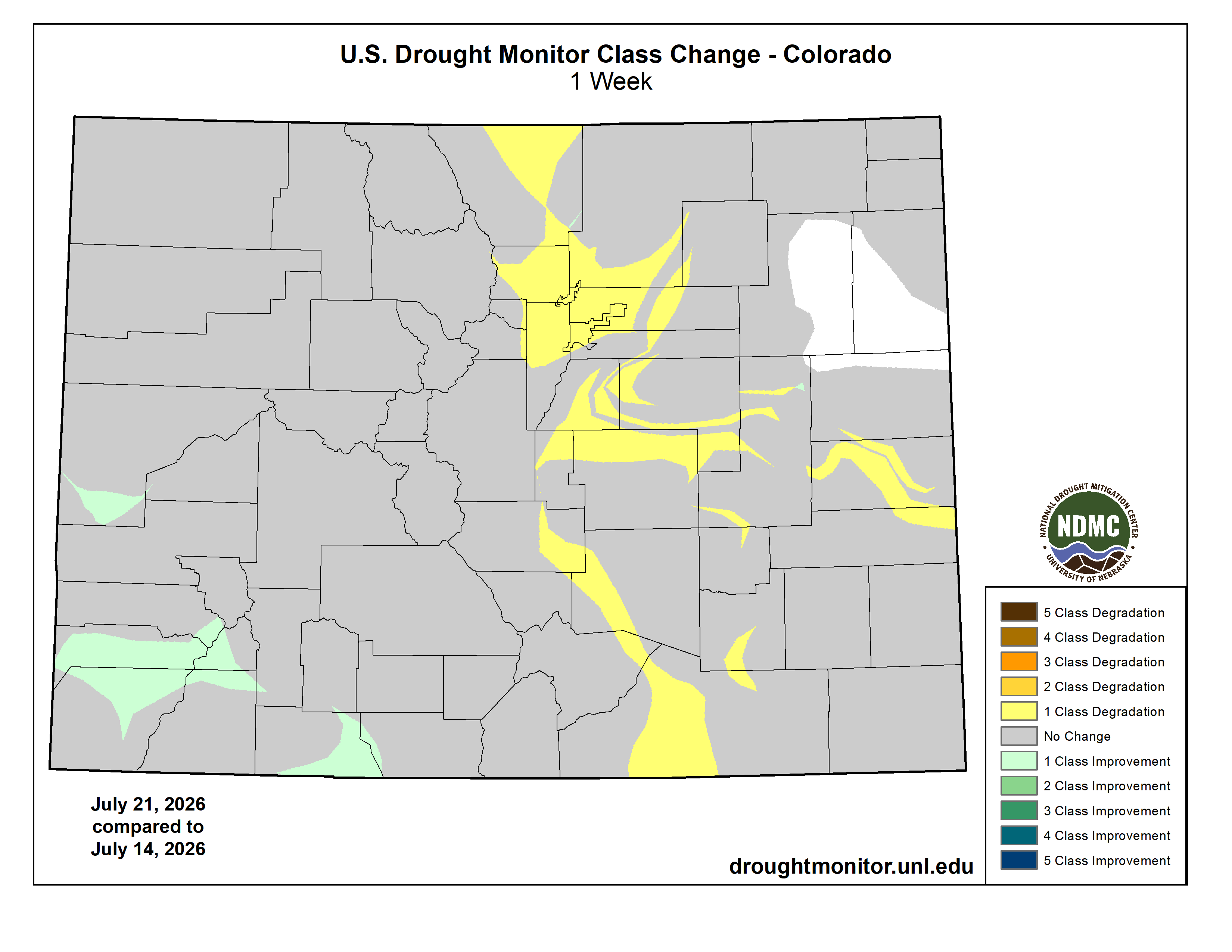
Below is the Colorado Drought Monitor one week change map ending July 21, 2026.
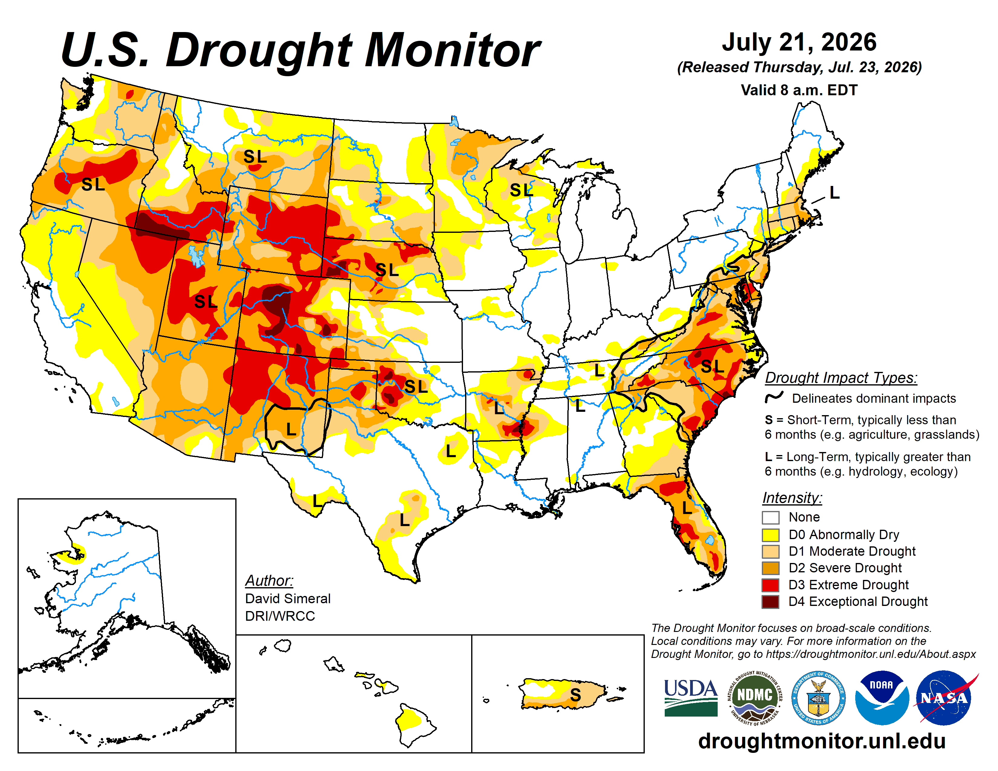
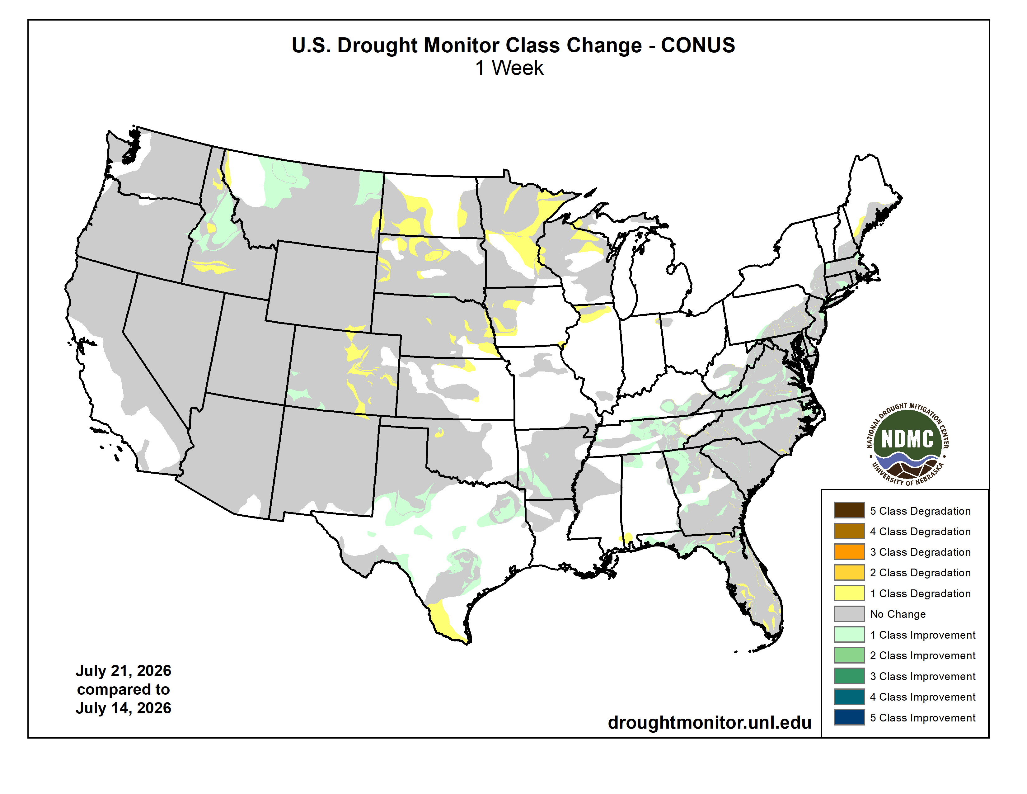
Here’s the US Drought Monitor Map from last week along with the one week U.S. change map.
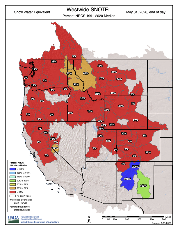
In the spring of 2026, anomalously low snow conditions in the western United States threatened winter recreation and water supplies. Here, we investigate: to what extent was this snow drought attributable to the climate change that has occurred since the pre-industrial period? We find that a snow drought this severe across the western United States was approximately 4.4 [95% CI: 2.6, 9.4] times more likely in the current climate than in the preindustrial period. In the Upper Colorado River Basin, the snow drought was approximately 14 times more likely [0.09, 4,300]. Given a projected increase in the frequency of snow droughts at least this severe in a moderately high emissions warming scenario, the lived experience of this event may help scientists, resource managers, and the public consider what western US snow might look like if greenhouse gas emissions are not aggressively reduced.