Northern Water will pay $30 million over the next 30 years to solve long-standing clarity and water quality problems at one of Colorado’s most treasured natural wonders, Grand Lake.
Under the terms of the agreement, the giant water provider will spend $1 million annually to test and implement new solutions to the problem, including weed control, aeration and sediment removal. The deal is the first time a dedicated source of money has been set aside to help the lake, Northern Water spokesperson Jeff Stahla said.
Grand Lake, located near the west entrance to Rocky Mountain National Park, is Colorado’s deepest natural lake and has been a major tourist destination since the late 1800s. A coalition of federal and state agencies, and local advocacy groups have been working and arguing over how to restore it since at least 2008.
“It has been a long and arduous process to get here,” Stahla said. “We’re hopeful that this is a turning point for being able to work together for the common good.”
Grand Lake is a key element of Northern Water’s Colorado-Big Thompson delivery system, which provides water to more than 1 million people on the northern Front Range and thousands of acres of irrigated farmlands.
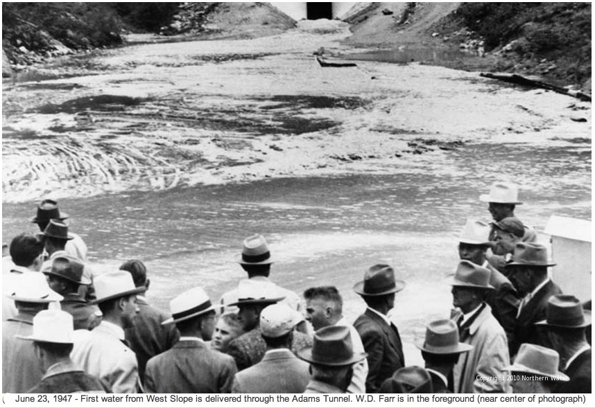
Owned by the U.S. Bureau of Reclamation and operated by Northern Water, The C-BT gathers water from the Upper Colorado River, and stores it in two holding pools built by the federal government: Lake Granby and Shadow Mountain Reservoir. From there it is eventually moved into Grand Lake and delivered via the Adams Tunnel under the Continental Divide to Carter Lake, west of Berthoud, and Horsetooth Reservoir, west of Fort Collins.
Colorado-Big Thompson Project map. Courtesy of Northern Water.
During that process, algae and sediment are carried into Grand Lake, clouding its formerly clear waters and causing algae blooms and weed growth, and harming recreation.
In 2008, the Colorado Water Quality Control Commission moved to set a clarity standard, but it has since been replaced with a clarity goal and the aim of achieving “the highest level of clarity attainable.” Since then, Northern Water and others have implemented different management techniques, including changing pumping patterns, to find ways to improve water quality in all three water bodies.
In 2016, the U.S. Bureau of Reclamation took the first steps required under the National Environmental Policy Act of 1969 to do the scientific and engineering studies needed to fix the system and hold public hearings. But Reclamation stopped the process in 2020, saying that it could not definitively establish any structural alternatives that would work, nor could it find a way forward on funding such a major infrastructure redesign.
Frustration among Grand Lake advocates continued to build, however, and in 2024, Colorado lawmakers passed a resolution calling for more work on the issue.
In 1941, before the Colorado-Big Thompson Project began operating, clarity was measured at 9.2 meters in depth, about 32 feet, according to Northern Water. Since 2016, the goal has been to achieve clarity of 3.2 meters, just over 9 feet. “We’ve been hitting the goals much more steadily than we have before, thanks to changes in the way the water is pumped through the system,” Stahla said.
Still the lake is plagued by infusions of warm, murky water during the summer and algae blooms that harm its recreational value, locals say.
Mike Cassio, president of the Three Lakes Watershed Association and a long-time Grand Lake advocate, said the new agreement was the only way the local interests could see to move forward, given what they say is an imbalance of power between the federal government and Northern Water, and the people of Grand County.
“The Bureau of Reclamation has estimated that replumbing and fixing Grand Lake is a $1 billion project and it would take a congressional mandate to fund it,” Cassio said. “Is this agreement the best that we have? Probably. Is anybody up for a fight with Northern and the Bureau? Probably not. So the best thing to do is to work together.”
In addition to the $30 million, the new agreement also expands the governing body overseeing the work to include the town of Grand Lake, which will for the first time have an official role in how the three-lake system is managed, Stahla said.
The Colorado River District, which represents 15 Western Slope counties, signed off on the deal this week, saying via email that the new agreement would provide a strong foundation for future work on the lake.
Other signers to the agreement include Grand County, the Northwest Colorado Council of Governments, Northern Water, and the town of Grand Lake. It must still be signed by the U.S. Bureau of Reclamation.
Why would a young Republican back solar power but reject a carbon tax? Why would two Democrats agree that climate change is real but split over a policy that would charge households more if they exceeded a monthly limit on energy use?
Those patterns may go against the partisan rhetoric of our times, but they reflect the reality that Americans do not sort neatly into simple camps on climate change.
We study complexsystems. In a new paper, we analyzed 20 years of Gallup environmental surveys, digging into individual responses from 2000 to 2020 that aren’t released to the public. We wanted to look beyond the usual headline that Democrats and Republicans disagree when it comes to climate change.
Rather than treating age, education, income and ethnicity as separate influences, we studied how they combine inside each party to shape climate beliefs and support for specific policies.
Belonging to the same party doesn’t necessarily mean holding the same views on climate policies, as 20 years of Gallup polls show. Al Drago/Getty Images
This deeper, more nuanced view changes the story by identifying people as more than just their political affiliations. To be clear, political party is still the strongest divide, but it does not tell us enough on its own. The same policy can mean very different things to different people, even within the same party.
We found several enduring themes.
1. Climate polarization deepened after 2017
A broad partisan split already existed, but it sharpened after Donald Trump first won election to the presidency in 2016. In Gallup polling from 2017, concern about global warming jumped among Democrats and independents, while Republicans stayed far less worried.
Our analysis shows that the greatest shifts in concern were among Democrats and independents, particularly those who worry about global warming, whether it is human-caused or natural, and whether it will threaten their way of life.
That matters because it suggests opinion on climate change and policy can be reshaped by political context.
2. Among Republicans, age is a major force
The biggest internal divide among Republicans was age.
Younger Republicans have often been much more open to renewable energy and much less supportive of fossil fuel expansion than older Republicans. In our data, Republicans ages 18 to 34 were more likely than older Republicans to oppose coal development and drilling in the Arctic National Wildlife Refuge. They also showed strong support for solar energy and alternative fuels.
Results from two decades of Gallup surveys. Yidan Sun, The Conversation, CC BY-ND
This is more than a descriptive age gap. The survey responses suggest that within today’s Republican coalition, climate and energy preferences are being sorted through different priorities. Younger Republicans appear more open to future-oriented energy development, such as spending more government money on developing solar and wind power. Older Republicans are more attached to established energy systems and the economic language surrounding them.
3. Climate policy support depends on what the policy asks people to do
One of the clearest lessons from our analysis is that support for climate action depends heavily on the design of the policy itself.
That distinction helps explain why public opinion on an issue such as climate can look inconsistent when it is viewed as a monolith. People are reacting not only to climate change itself but also to what a policy signals about government, markets, fairness and personal cost.
This finding fits with earlier research on solution aversion: When threatened by a solution, a person’s belief in the problem itself may be challenged.
We found something similar across the political spectrum with proposals to legally limit household energy use. Those were unpopular not just with Republicans but also with many Democrats and other respondents who described themselves as concerned about climate change. Even people who accept that there is a problem may resist solutions that feel coercive or too close to everyday private life, meaning policies that interfere directly with daily household choices or bills.
4. Education does not erase the partisan gap
A common but mistaken assumption is that more education naturally leads to more agreement on climate change. Our results point to a messier reality.
Among Democrats, higher education was linked to stronger support for climate policies such as carbon taxes, emissions standards for business and industry, and renewable energy investment. College-educated Democrats were especially supportive of regulatory and tax-based climate policies, such as imposing mandatory controls on carbon dioxide emissions and passing a carbon tax to encourage people and industries to reduce their carbon dioxide emissions.
Among Republicans, education did much less to reduce skepticism about climate policies. Better-educated Republicans did not simply converge toward Democrats. In some cases, they remained skeptical of climate regulation even while showing support for technologies such as nuclear power.
Results from two decades of Gallup surveys. Yidan Sun, The Conversation, CC BY-ND
We believe that this is one of the most important analytical lessons in the study. Education is not just adding information into a neutral space. It is interacting with party identity. The same increase in education can deepen support for climate policy in one partisan context while leaving skepticism largely intact in another.
5. The biggest group is the ‘mixed middle’
The largest group in our analysis was not those most concerned about climate change or the skeptics. It was the mixed middle: people with complicated, sometimes inconsistent views.
That group matters because it suggests American opinions on climate change are polarized but not fixed. The surveys showed that this middle group was the largest of the three Gallup clusters: 10,617 mixed-middle respondents, compared with 6,682 who were highly concerned about climate change and 3,102 skeptics. Many people are neither fully convinced nor fully dismissive of the need for policies to counter the drivers of climate change. Their views depend on the issue, the framing of policy proposals – for example, whether it is presented as a tax or an incentive, a regulation or a technology investment – and the trade-offs involved.
If there is a practical takeaway from 20 years of climate surveys, it is this: Political party remains the strongest clue to how Americans think about climate change, but to understand where opinion might move next – and which policies might actually gain support – requires looking deeper than the party label.
Earlier this week, President Donald Trump issued a proclamation dramatically reducing Bears Ears National Monument and terminating the Bears Ears Commission, undermining years of progress in collaborative management. The decision weakens protections for a living cultural landscape. This sacred ancestral homeland has been cared for by Indigenous peoples since time immemorial. This is a major setback to one of the nation’s most extraordinary models of collaborative management of public lands between Tribal Nations and federal agencies…
The Bears Ears Commission is composed of five Tribal Nations—the Hopi Tribe, Navajo Nation, Ute Indian Tribe of the Uintah & Ouray Reservation, Ute Mountain Ute Tribe, and Zuni Tribe. They work collaboratively with the U.S. Bureau of Land Management and U.S. Forest Service to manage and steward Bears Ears National Monument. The Bears Ears Commission exemplifies collaborative management between sovereign Tribal Nations and the federal government. The Commission was established following the designation of Bears Ears National Monument in 2016.
According to a statement from the commission last week, “The significance of Bears Ears cannot be reduced to a handful of individual sites or separate management areas. Tribal Nations understand Bears Ears as an interconnected living cultural landscape, where the land itself—and the relationships among its cultural sites, waters, plants, animals, and sacred places—are what must be protected.”
Over the past several years, the Bears Ears Commission has worked alongside the Bureau of Land Management and U.S. Forest Service developing and implementing the Bears Ears Resource Management Plan. This collaborative management framework is grounded in Traditional Indigenous Knowledge and western science. The plan remains a historic achievement. It demonstrates how Tribal leadership, Indigenous Knowledge, and western science can work together to care for one of America’s most significant regions in a way that protects the cultural, historical, ecological, and scientific values that make Bears Ears cherished by Tribal Nations and all who visit and experience it. In June 2025, the Department of the Interior stated in writing that, if it considered changes to the boundaries, management, or designation of Bears Ears National Monument, it would contact the Bears Ears Commission to schedule a meeting. The Commission expected meaningful government-to-government consultation and the Department’s written commitment to be honored before decisions affecting Bears Ears National Monument were made. But no such consultation occurred. The proclamation also terminates the Bears Ears Commission, despite years of collaborative work carried out through the Commission and its government-to-government relationship with federal agencies. The president’s action not only reneges on the Department’s assurances in the June 2025 letter, but is also contrary to the terms establishing the Commission in Proclamation 10285 and the Inter-Governmental Cooperative Agreement between the Commission Tribes, the Bureau of Land Management, and the U.S. Forest Service for collaborative management of the Monument.
Elk Ridge, Utah. Photo credit: Tim Peterson via the Bears Ears Inter-Tribal Coalition
Little doubt was left following the conclusion of Tuesday’s [July 21, 2026] water court session that the Subdistrict 1 Fourth Amended Plan of Water Management will ultimately be decided on appeal by the Colorado Supreme Court.
Division 3 Water Court Judge Michael Gonzales said as much as he ruled, following arguments, to allow testimony from former state engineer Kevin Rein, who is expected to testify as a rebuttal witness on Wednesday morning.
Ryan Donovan, attorney for the Northeast Water Users Association and Sustainable Water Augmentation Group which are protesting the subdistrict plan, argued that Rein should not be allowed to testify as a “lay witness” to rebut the testimony of SWAG expert witness Ken Knox.
He also told Gonzales that his comments at the conclusion of the court session on Friday, July 17, where the judge made known his interest in hearing from Rein, created the appearance of impropriety which would be grounds for appeal should Gonzales rule against NWUA and SWAG in their bid to have the plan rejected by the water court.
“Now the supporters wish to call the exact witness identified by the court to the stand and are using the court’s statement as a basis for doing so. This tells me that the supporters would not be calling Mr. Rein, but for those statements. The extent the court relies on Mr. Rein’s testimony to fill the gaps in the state’s case and Mr. Rein’s testimony serves as a basis for the court’s ruling, NWUA and SWAG certainly have a colorful issue on appeal because the statements and the proponent’s subsequent action in response to those statements create the appearance of impropriety,” Donovan said.
In making his ruling that Rein could testify and that Rein’s testimony would be part of the court’s deliberations, Gonzales told Donovan and Subdistrict 1 attorney Pete Ampe that from his perspective, it’s felt that all sides have been working toward an appeal rather than to convince him.
“Pretty much all the evidence I’ve heard for the last three weeks has been cumulative, could be considered a waste of time and confusing. The same argument you just made for the evidence that I potentially could hear from Mr. Rein … I’ve let you guys present as much evidence as possible. I think maybe I have sustained two objections the entirety of the trial so that all the evidence comes in so the court has a basis to make what I would call a very ‘unenviable decision’ to quote language used by others and to be able to rely on enough information, sufficient information.
“I’ve let it all come in. I haven’t stopped, really, anybody from presenting any evidence during the course of these proceedings. Quite frankly, I will tell you from my perspective…it’s felt like no one really has been concerned as to what decision this court is going to make because you’ve been setting up an appeal from the very beginning on both sides, on all sides.That’s what it’s felt like,” Gonzales said.
Earlier in the day, Jake Burris, president of the Subdistrict 1 Board of Managers, and Subdistrict 1 farmer Lyle Nissen testified in support of the Fourth Amended Plan as rebuttal witnesses to testimony from farmers SWAG put on the witness stand.
Nissen walked the court through all the ways he has retooled his farming operation in light of the declining unconfined aquifer.
“It is a different day, a different time. We’ve got to have rules. We have to have parameters. We have to get to the point where we’re sustainable,” Nissen told the court.
The water trial resumes Wednesday [July 22, 2026], with final arguments coming as early as Thursday.
As we enter the thick of watering season in mid-July, it’s a good time to assess how Denver Water customers are doing in cutting water use amid a drought.
The early verdict: Good but needs to be even better.
Denver’s Board of Water Commissioners, in its drought declaration of March 25, called for a 20% reduction in water use over the coming year.
By one important measure, the 1.5 million people Denver Water serves are meeting that goal. Customers are using about 20% less than projected — when the record-setting hot and dry weather we’ve experienced in 2026 is factored in.
By another measure, against the five-year average, customers are conserving water — but have a ways to go to hit the goal. Using the five-year average sets a tough bar, however, as those years were not generally as hot and dry as what the Denver region has seen so far this year.
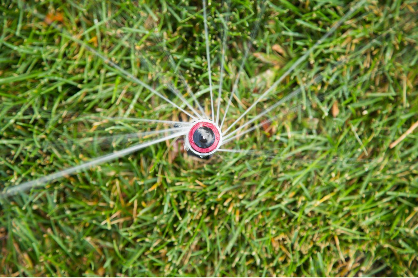
Get tips for helping your lawn survive the summer on mandatory drought restrictions that allow residential water only on two assigned days per week. Photo credit: Denver Water.
Overall, when you consider the conditions, the high temperatures and lack of precipitation, we think customers are doing well,” said Greg Fisher, manager of demand planning for Denver Water. “They are showing restraint even as the spring and early summer continued the record-breaking drought numbers we saw last fall and winter, combined with extremely high temperatures.”
In fact, tracking at Denver Water’s three weather stations, spaced out west to east across the metro area, shows January through June of 2026 experienced the highest daily average temperature ever, at 67 degrees, compared to an average of 62 degrees.
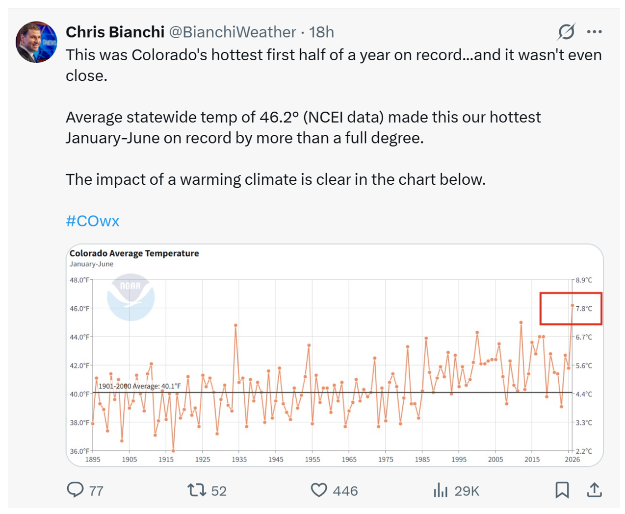
9News meteorologist Chris Bianchi’s July 9 post on Twitter noted that Colorado has just experienced the hottest opening half of the year on record, “and it wasn’t even close.” Image credit: Chris Bianchi via Twitter.
Colorado as a whole is seeing the same trend, with 9News meteorologist Chris Bianchi reporting that it was the hottest opening half of the year on record, “and it wasn’t even close,” he noted on Twitter July 9.
The average temperature of 46.2 degrees beat the previous mark by a full degree. “The impact of a warming climate is clear,” Bianchi noted.
The weather has taken a toll, putting water supplies and landscapes in a major water deficit, Fisher said. Even so, customers have heard the call for conservation.
Overall, they adhered to Denver Water’s call to hold off on activating sprinkler systems until mid-to-late May or even June.
But as spring rains retreated and temperatures rose, watering season hit its stride and the hot weather predictably drove up use to levels similar to the five-year average recorded from 2021-2025.
Now, as we enter the heat of July and August, Denver Water should get a better sense of how well customers continue to keep water use in check and hold to mandatory two-day-a-week watering schedules.
Suggested watering times that comply with Denver Water’s mandatory drought restrictions that limit outdoor watering to two days per week. Image credit: Denver Water.
Mother Nature may help, with some climate models suggesting the potential for a rainier summer that could reduce the need to turn on sprinklers, cut demand and keep water in Denver Water reservoirs.
“It’s so important for customers to pay attention to the weather, and keep irrigation systems off around rain events,” Fisher said. “A good rainstorm should allow you to take your watering day off and, in some cases a rainy week means you can skip watering on both designated days.”
Preserving water supplies in Denver Water’s reservoirs is key.
Overall reservoir levels, as of July 13, are currently around 78% percent full (compared to percentage levels usually in the high-90s at this time of year), but levels are dropping as summer watering hits full stride.
The more Denver Water customers can stretch those supplies, the quicker the storage levels can begin to recover after a year — or more likely years — of better winter snowpack.
Too much drawing down of precious water supplies stored in reservoirs could be consequential for water users.
Antero Reservoir in 2026, after its water was moved to Cheesman Reservoir to reduce the amount of water lost to evaporation. Photo credit: Denver Water.
Should supplies drop too low this summer, water planners would potentially consider reducing outdoor watering to one day a week to further ease pressure on supplies and avoid an even larger storage deficit next spring. So now is the time to pay close attention to water use outdoors — and indoors.
Every bit you save, whether it’s while you shave, shower or water the lawn improves the chances we can avoid even tougher restrictions and look with hope for a stronger winter to come and begin recovering storage supplies.
“We need people to be thinking bigger than this week or this year when they think about water,” Fisher said.
“Even with watering restrictions in place now, we’ll enter next year with a water deficit due to the record snow-drought last winter. Recovering from that requires not only some good snow years, but thoughtful conservation from our customers.”
Every year, billions of migratory birds connect the world’s continents, oceans and ecosystems as they undertake epic journeys between their foraging habitats and their breeding grounds.
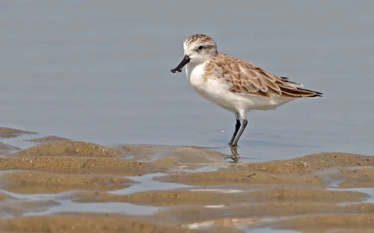
A bobolink (Dolichonyx oryzivorus) leaves its breeding grasslands of North America for the Pampas of South America. A Newell’s shearwater (Puffinus newelli) spends months soaring across the North Pacific before returning to the Hawaiian Islands to breed. A spoon-billed sandpiper (Calidris pygmaea) travels from Arctic Russia to the rapidly disappearing tidal mudflats of Southeast Asia for its nonbreeding season.
These birds could hardly be more different. They occupy different habitats, follow different migratory routes and face different threats. Yet they share one remarkable characteristic: Their survival depends on networks of habitats stretching across thousands of miles and multiple countries.
The bobolink breeds in the grasslands of North America, but it makes an epic migration journey to South America each year. Grayson Smith/USFWS.
Today, all three species and many others are in trouble. Their migrations remain among nature’s greatest spectacles, but the birds themselves are increasingly at risk as the habitats and ecological connections they depend upon are lost or degraded and threats to their survival and ability to reproduce increase.
The results are sobering. We found that more than half of the world’s migratory bird species are declining because of an array of threats, including habitat loss, invasive species that harm birds, collisions with buildings, hunting, the pet trade, toxic pesticides and, in some cases, being caught in commercial fishing nets.
But our study offers a second conclusion with more hope. The science around migratory birds has changed dramatically over the past two decades, and conservation can help save these incredible species – if governments act before they become endangered.
Protecting birds across their epic journeys
If migratory bird conservation is refocused on the birds’ full annual cycles, it can protect birds and their habitats throughout the year, from their breeding grounds to their nonbreeding homes and their migratory routes in between.
This approach combines protecting and restoring important places, reducing threats wherever they occur. It also relies on international cooperation and proactive conservation led by engaged governments before species become endangered.
Some of the amazing migrations that take place around the world. (a) The lines reflect prebreeding (solid) and postbreeding (dashed) migration routes of several birds. (b) Some birds, like the Hudsonian godwit (Limosa haemastica), a member of the sandpiper family whose annual cycle is shown here, travel thousands of miles. (c) The Barau’s petrel (Pterodroma baraui) spends much of its nonbreeding time over islands and open water. (d) Other species, like the giant hummingbird (P. gigas) found in the Andes mountains, travel to higher elevations after breeding. Nature Reviews Biodiversity/Peter P. Marra, et al., 2026
The encouraging news is that humans have never been better equipped to reverse these species’ declines.
Researchers attach a satellite transmitter to the back of a red knot, a rapidly declining migratory species. Tiny trackers like these show migration routes and help locate the potential harms and ways to help these species. Tim Romano, courtesy of the Smithsonian InstitutionTrackers on birds are like tiny backpacks. Smaller than a penny, birds can carry them hundreds of miles, giving scientists insight into their patterns and habitats and ways to help them survive. Tim Romano, courtesy of the Smithsonian Institution
For the first time, scientists can follow individual birds across continents and determine where conservation actions will have the greatest impact.
A new strategy
For much of the past century, migratory bird conservation focused on protecting important places, such as the breeding grounds, wetlands, nonbreeding habitats and migration stopover sites birds depend upon.
That strategy has been enormously successful and remains indispensable. Protected areas have prevented countless extinctions and will continue to be a cornerstone of biodiversity conservation.
A scientist releases a Kirtland’s warbler with its tracker attached. Tim Romano, courtesy of the Smithsonian Institution
But research has revealed something equally important: Protecting places, while essential, is often not enough to conserve species whose lives unfold across continents and oceans. It’s also important to understand where and when populations are most at risk and address those constraints across the birds’ entire annual cycle.
The three species that opened this story illustrate why.
Bobolinks breed across North American grasslands but spend much of the year in South America. Conserving breeding habitat alone cannot reverse their declines if grasslands continue to disappear or if birds are poisoned by pesticides.
Critically endangered spoon-billed sandpipers depend on a shrinking network of tidal mudflats that serve as stopover sites between their breeding grounds on Russia’s Chukotka Peninsula and their nonbreeding areas in Southeast Asia. Losing even a handful of these staging areas can jeopardize one of the world’s rarest migratory birds.
Each species requires a different conservation strategy, but all require the same way of thinking: conserving their entire annual cycle rather than focusing on a single place, season or threat.
Fortunately, this approach is already starting to take hold in the United States and demonstrates what is possible.
What success can look like
Road to Recovery is an international initiative designed to reverse the losses of North America’s fastest-declining bird species before they require protection under U.S. endangered species legislation.
Rather than waiting for populations to collapse, Road to Recovery brings together scientists, governments, conservation organizations, landowners and local communities to form species working groups. These groups help identify the harms bird populations are facing and how to be more surgical in where limited conservation dollars are invested.
However, the convention’s effectiveness is severely hindered when many of the world’s largest, wealthiest and most influential countries have not signed on to it. That includes the United States, Canada, Mexico, Russia and Japan.
Broader international participation and sustained investment from governments can help translate scientific knowledge into coordinated conservation action across the full annual cycle.
Around the world, conservation initiatives repeatedly demonstrate that when threats are identified and addressed, bird populations recover. The pesticide DDT almost caused the extinction of species such as the bald eagle, peregrine falcon and osprey, but humans stepped in, banned its use, and all species recovered.
The challenge now is applying what science has found.
Next spring, bobolinks will once again return to North America’s grasslands. Newell’s shearwaters will navigate thousands of miles of open ocean back to Hawaii. Spoon-billed sandpipers will once again attempt one of the world’s most extraordinary migrations.
Whether future generations can continue to see these magnificent migrations will depend on the choices of current generations and the steps they take to save them.
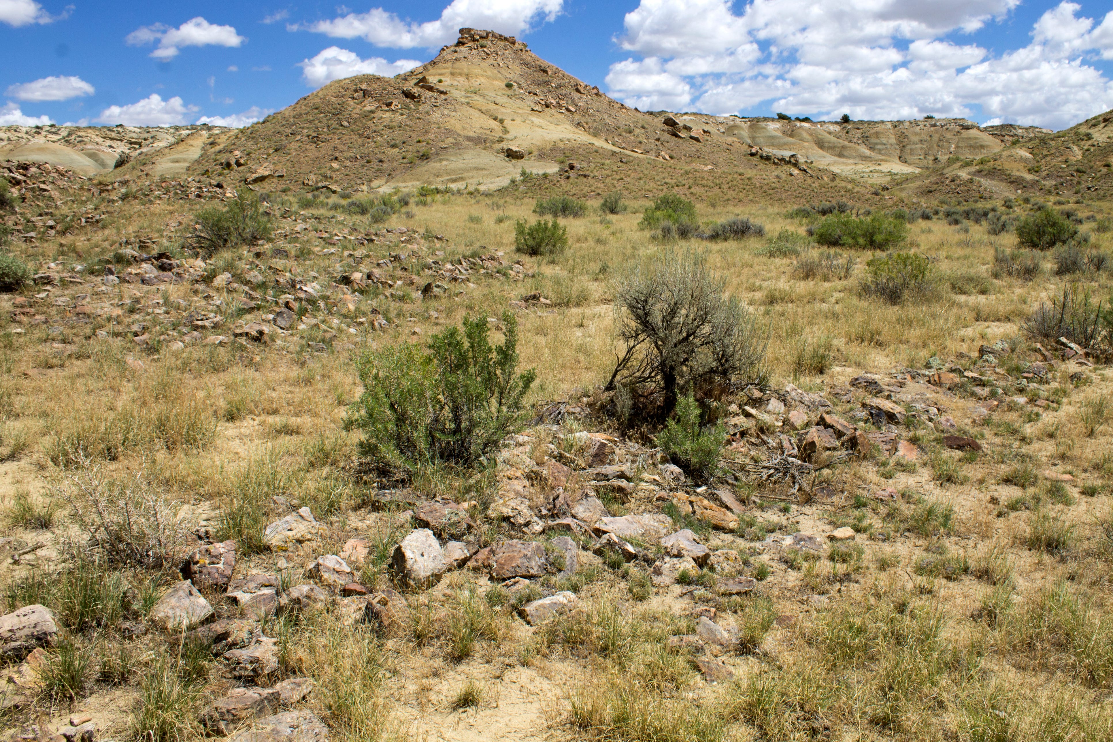
While this may not resemble the monumental structures in Chaco Canyon at first glance, a closer look reveals the outlines of ancient walls, shrines, and a Chacoan great house known as Pierre’s. The pueblo is in the San Juan Basin north of Chaco Culture National Historical Park and is just inside the 10-mile buffer zone. While the site is protected by additional federal laws, its surroundings — which can include corn fields, “roads,” and other cultural sites — would be vulnerable to oil and gas drilling if the administration rescinds the leasing moratorium. Jonathan P. Thompson photo.
THE NEWS: The Trump administration is moving forward with its bid to revoke a 20-year moratorium on federal oil and gas leasing around Chaco Culture National Historical Park in northwestern New Mexico. The Bureau of Land Management is giving the public just two weeks to comment.
THE CONTEXT: The GOP’s assault on public lands, cultural resources, and tribal nations is reaching a fevered pitch this week. The latest attack is on the 10-mile “buffer zone” around the park, where the Biden administration banned new drilling in an effort to protect a small part of the greater Chacoan cultural landscape.
When President Theodore Roosevelt wielded the brand new Antiquities Act in 1907 to create Chaco Canyon National Monument, he drew the boundaries around what is now known as “downtown Chaco,” a handful of structures including the 800-room Pueblo Bonito, constructed between the 9th and 12th centuries by ancestors of today’s Pueblo people.
That was merely the center of the Chacoan world, however, which extended over 100 miles outward into the Four Corners region, which may have been a political empire, a religious or cultural society, a school of architecture, or all of the above. Dozens of Chacoan outliers or “great houses,” along with thousands of smaller sites, shrines, and architectural features with unknown function, did not exist in isolation. They were part of a cultural tapestry woven into the natural landscape. The national monument, in other words, was vastly incomplete, which is especially concerning given that it lies in what would become one of the nation’s most heavily drilled oil and gas fields.
It was with this greater context in mind that in 2023, after years of consideration, public meetings, and analysis, President Joe Biden signed Public Lands Order 7923, which withdrew about 336,000 acres of public land from oil and gas leasing for 20 years. Tribal nations with ties to the cultural landscape, environmental advocates, and archaeologists had sought the withdrawal to provide a buffer zone around the national historical park and to add a layer of protection to the associated sites within 10 miles of the park’s boundaries.
But Project 2025 called for these kinds of withdrawals to be rescinded, and the Trump administration has begun the process of complying. Keep in mind that this does not directly affect the park or the cultural resources therein. Chaco is a national park, and oil and gas leasing and drilling and other development is prohibited; only Congress can change that. Drilling rigs won’t be going up next to Pueblo Bonito, but drilling just outside the park could affect the park’s viewsheds and soundsheds.
The BLM is now inviting public input, for a very limited time, on three alternatives: 1. keeping the ban in place; 2. shrinking the 10-mile buffer zone to just five miles; 3. eliminating the ban altogether. To comment, click on this link and then click on the “Participate Now” button at the top of the page.
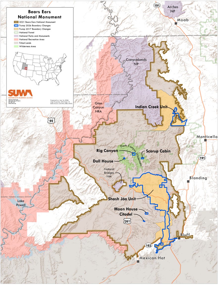
The maps illustrate the carnage of the Trump administration’s evisceration of Bears Ears and Grand Staircase-Escalante National Monuments better than mere numbers, and show exactly from where the 2.93 million acres of protections were rescinded. They also lay bare just how much Trump removed from the shrunken national monuments that remained after Trump I’s 2017 reduction.
I’ve turned to the maps for another reason these past few days: To try to discern some sort of pattern or logic in where the lines were drawn this time, and why they are so radically different than in 2017. I’ve found that looking at the lines on the maps is more like taking a Rorschach inkblot test: You can come up with some decent sounding explanations, but there’s not much to back them up with.
When the Trump administration rolls back limits on smokestack pollution from coal plants, lowers royalty and reclamation bonding rates for oil and gas facilities, or lower water quality standards, it’s clearly doing so to help their corporate buddies rake in even more profits. When they slash millions of acres from two national monuments, the intent is more ambiguous, perhaps even for the ones making the decisions.
Certainly shrinkage generally is motivated by Trump’s spite towards his more popular predecessors, Bill Clinton and Barack Obama, the ones who originally established Grand Staircase-Escalante and Bears Ears national monuments, respectively. But beyond that Trump himself is in the dark: He actually believes that people are unable to hike, hunt, camp, or fish in these national monuments, which simply is not true. Not only are all of those things allowed, but so are motorized travel on hundreds of miles of designated roads, vegetation management, livestock grazing, and commercial activities.
The main activities these national monuments restricted were new mining claims and new oil and gas, coal, and other energy-related leases (existing active valid leases and claims are not affected by the designation). So, clearly, at least part of the motivation here is to reopen certain lands to the extractive industries. Trump’s proclamations affirm this: They say the land needs to be opened up to miners and drillers to extract “several resources that are vital to energy and resource independence” such as “silver, copper, molybdenum, lead, uranium, vanadium, and zinc.” And, of course, we all know by now that Trump’s “energy dominance” agenda includes leasing out as much land as possible — whether it contains oil and gas or not — to the petroleum companies.
The administration is also hoping to trigger a lawsuit that could make its way to the Supreme Court, where it would become a test of the Antiquities Act, itself. Plus it’s looking to open the door to allowing Utah or county governments have more control over federal land. That might be a gift to Sen. Mike Lee to show appreciation for his groveling sycophancy towards Trump, which has become more valuable with the death of Sen. Lindsey Graham.
In other words, the motivations are pretty similar to when Trump shrunk the monuments in 2017. It was clearly done in part to open up known reserves of oil and gas, uranium, coal, and potash. This is made obvious not only by communications between industry and the administration prior to the shrinkage, but also by the fact that Trump I’s shrinkage lines followed known resource reserves, not the boundaries proposed by local and state officials.
For example, the 2017 redraw cut out the Circle Cliffs historic uranium and copper mining district on the far northeast side of GSENM, probably to allow access to those reserves. And while it left part of the vast Kaiparowits coal field in the national monument, it made cutouts for the former Smoky Hollow coal lease, where Andalex had planned on building a gargantuan mine prior to the 1996 designation. At Bears Ears, the 2017 shrinkage cut out the White Canyon uranium mining district, where there’s also tar sand development potential.
This brings up a lot of questions. First off, why did Trump II go to the trouble of redrawing completely new boundaries this time around rather than just re-upping the 2017 lines? After all, they achieved all of the same goals as the bigger, current shrinkage, while also keeping a few more valued landmarks under monument status. The Six Shooter peaks and Bridger Jack Mesa were kept in the Indian Creek Unit of Bears Ears under the 2017 shrinkage, for example, but left out this time. Why?
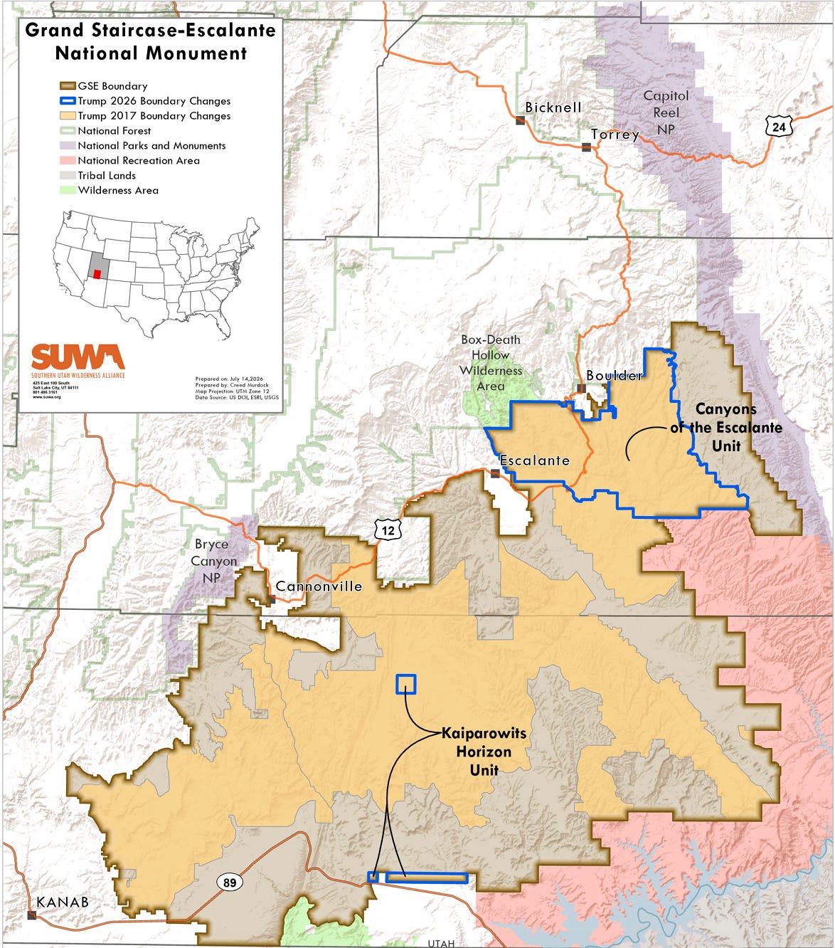
The most dramatic change, even from Trump’s 2017 boundaries, is to what is now known as the Kaiparowits Horizons Unit of GSENM, where the national monument was eliminated save for a seemingly arbitrarily placed square on Long Flat and a rectangular strip on the East Clark Bench. The latter strip was kept intact because it is where anthropologists found the bones of Sarabosaurus dahli,a new taxon of sea-going dinosaur Turonian mosasaurid. But removed from monument status were hundreds of significant landmarks, from the Cockscomb to Grosvenor Arch to the entire Kaiparowits Plateau.
The 2026 shrinkage does open up the entire Kaiparowits coal field. But it also nixed the whole Grand Staircase Unit, where there are no known mineral reserves.
Perhaps trying to find logic somewhere in the collective brains of the Trump administration is a fool’s errand. I’m certainly not seeing it in these maps. But maybe you can? Check them out and let me know! As is always the case with this sort of detailed image, the best experience is had on the Land Desk website. So if you’re reading this in your email browser, you’d be best off clicking on the headline above, and it will take you straight to the site, where clicking on the images will give you a larger view.
Southern Utah Wilderness Alliance did a nice map of the cuts in Bears Ears. The cuts to the original boundaries were drastic, to put it mildly, excluding the entirety of Cedar Mesa, Mancos Mesa, White Canyon and its tributaries, Dark Canyon, most of Butler and Cottonwood washes, Grand Gulch, and the Valley of the Gods. The changes from the 2017 shrinkage were relatively small in the Shash Jaa Unit, but the Indian Creek Unit was reduced substantially this time around, leaving out the Six Shooter peaks and Jack Bridger Mesa.
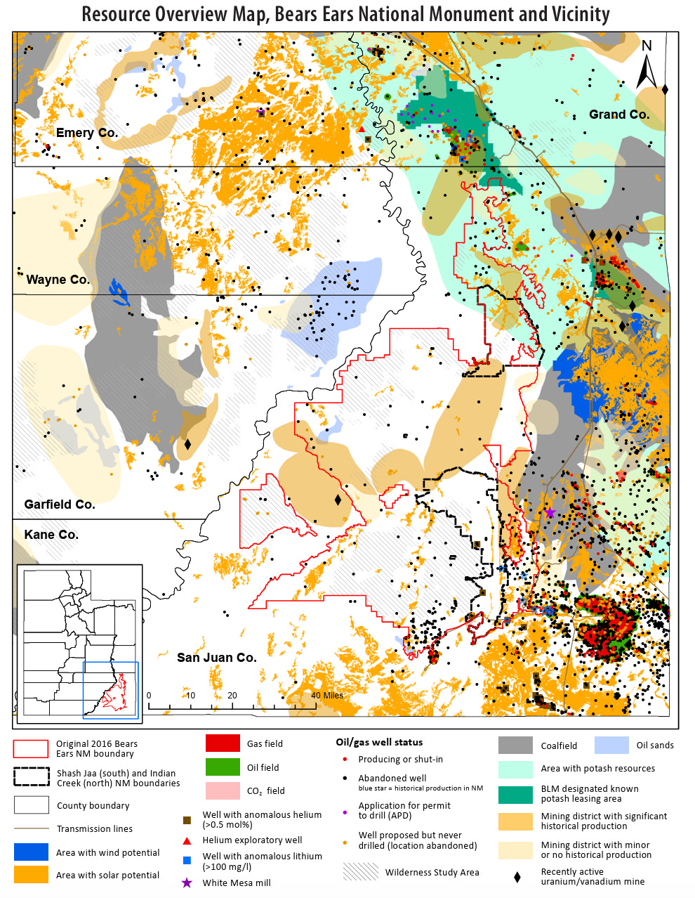
The Utah Geological Survey’s Resource Overview Map (showing the original 2016 and Trump-shrunken 2017 BENM boundaries) shows that the 2026 boundaries appear to have been drawn to exclude potash and uranium resources that were left within the national monument after the 2017 shrinkage.
SUWA’s map shows the near total elimination of the central, southern, and western portions of GSENM, leaving only two little portions that are now called the Kaiparowits Horizon Unit. The southern strip is where researchers found the bones of the Sarabosaurus dahli. Source: SUWA.
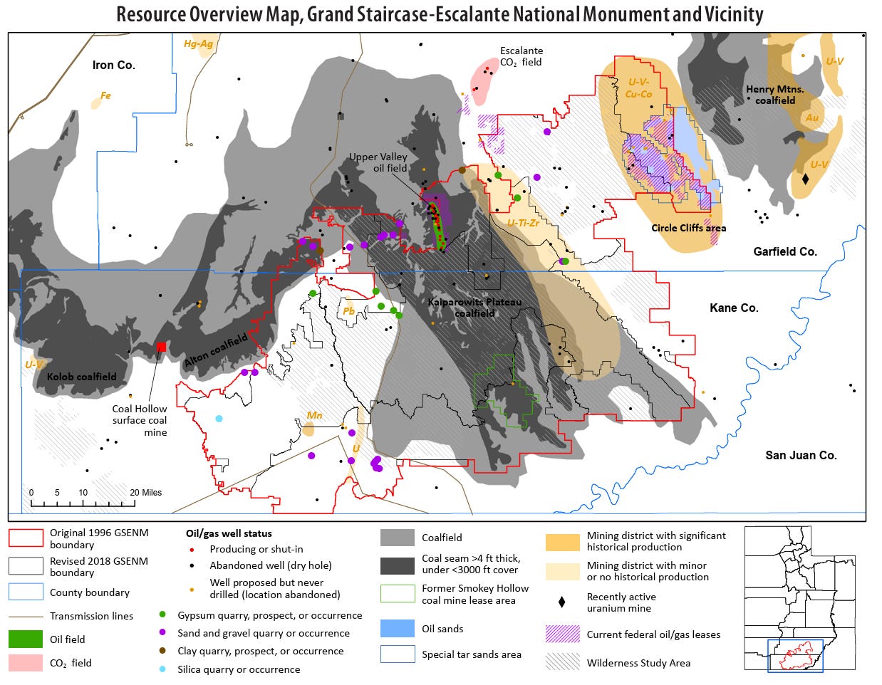
The UGS Resource Overview Map indicates that Trump I slashed the Circle Cliffs area from GSENM due to its uranium, vanadium, and copper potential. The 2017 shrinkage also made cutouts for places with high coal recovery potential. But it kept the southwestern part of the national monument — where there is little known resource potential — relatively intact. The 2026 shrinkage eliminated all of that.
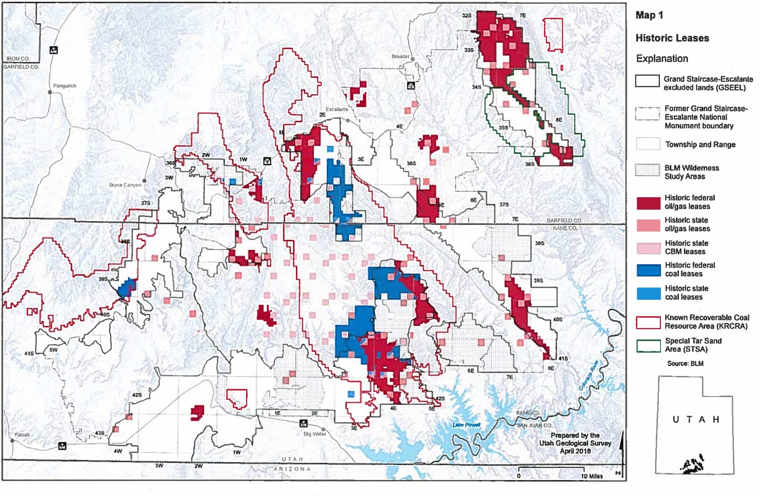
Here’s another map by the Utah Geological Survey showing historic coal and oil and gas leases. Again, if you compare this to the maps above, you’ll see that the 2017 shrinkage made cutouts for these places. While the 2026 shrinkage also cut these places out of the national monument, it didn’t open up significantly more leases than the 2017 shrinkage did.
Here I overlaid the Resource Overview maps onto a BLM map showing the original boundaries of GSENM (in black), the 2017 boundaries (in brown) and the 2026 shrinkage boundaries (in red). This suggests that the 2026 shrinkage was looking to free up all of the Kaiparowits coalfield. It also freed up a lithium deposit along the Hole in the Rock road. Source: BLM, USG, Land Desk map.
🏠 Random Real Estate Room 🤑
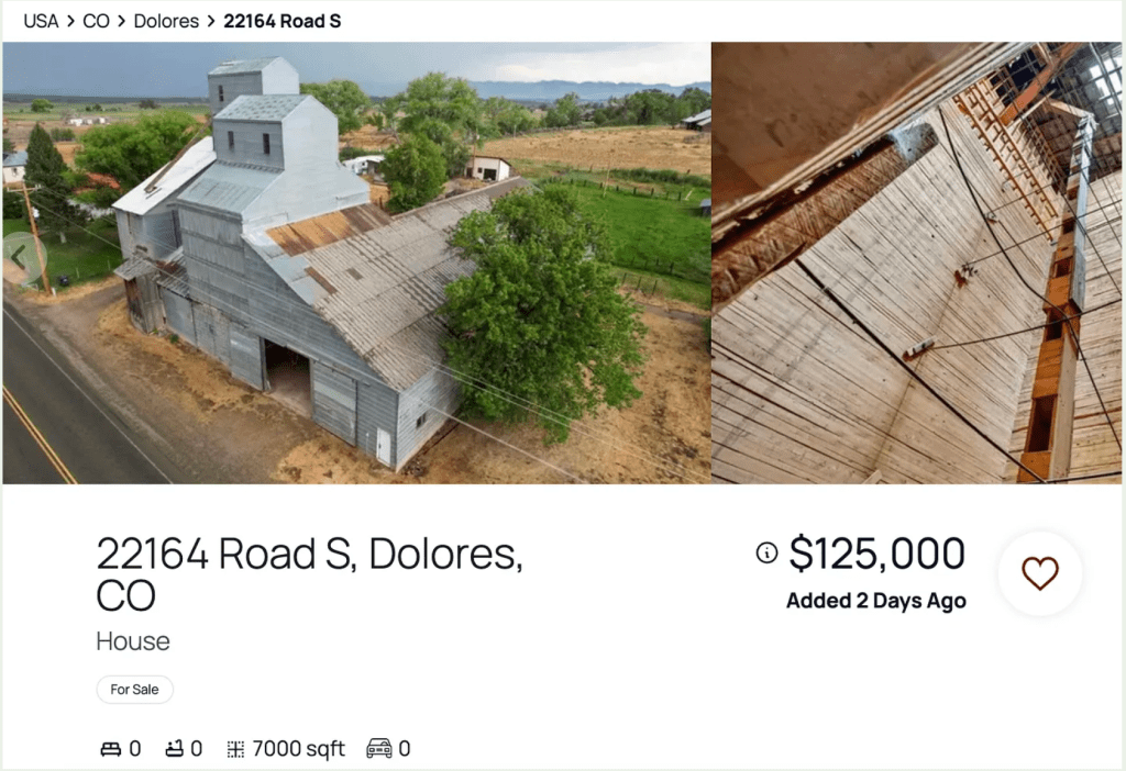
Well, here’s some relatively affordable housing. Or something like that. I could see turning this thing into a giant art studio, event-space, and housing. And it’s in a lovely part of the world, too! The ad gives a Dolores, Colorado, address. But it’s actually in Arriola, which is about halfway between Cortez and Lewis.
The North American monsoon season is ramping up across the West, with the potential to bring much-needed rain as Colorado faces a historic drought and major wildfires, according to forecasters. National Weather Service forecaster Kris Sanders said that widespread, scattered showers and thunderstorms on the Western Slope this week could be an early sign of the monsoon, or a late-summer shift in the wind patterns that brings more moisture to the region….A rainy monsoon season could be good news for the drought-stricken mountains. Large parts of Summit, Grand, Eagle, Pitkin, Moffat, Rio Blanco, Garfield and Lake counties have been experiencing exceptional drought — the highest level — for nearly three months straight, according to the U.S. Drought Monitor. Almost the entire Western Slope is experiencing severe drought, Level 2 of 4, or higher. But Smith also noted that the monsoon can be a double-edged sword that can bring lightning and wind, which can increase wildfire risk. It also creates new hazards for those recreating outdoors.
















.jpg)