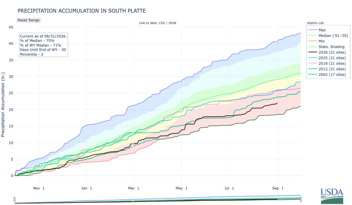
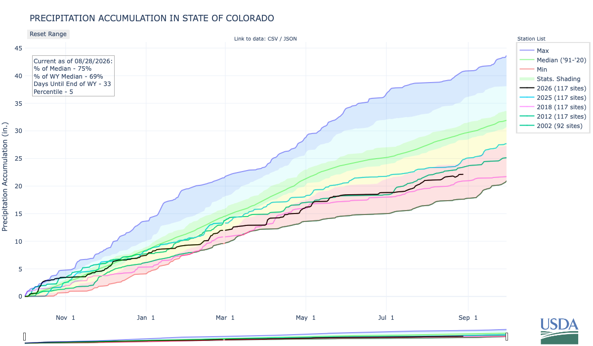
Below is the Precipitation Accumulation in South Platte graph from the NRCS for August 31, 2026. This morning precipitation, at the SNOTEL stations, is at 75% of the median (no change one week), and 71% of the water year median (up 2% one week). There are 30 days left in the water year.
Showers are likely today, there is a chance for thunderstorms Friday, and a chance for showers and thunderstorms Saturday in the central mountains. Showers a likely today, with a slight chance for thunderstorms Friday, and a chance for showers/thunderstorms Sunday in the northern mountains. Showers are likely today, with a slight chance for showers Friday, and a slight chance for showers and thunderstorms on Saturday and Sunday, down here about 6.0 miles from the U.S. Mint where The ‘Wildest Gun Battle in Denver History’ Was Also the First Successful Mint Holdup in the U.S. Here’s an excerpt from Law Week Colorado:
1920s Denver is often associated with bootlegging, booming population growth and tumultuous governmental control as powerful legislative and executive seats were taken by members of the Ku Klux Klan. 1922 is also when the Denver Mint was robbed by a gang of bandits, culminating in the “wildest gun battle in Denver history,” according to the Craig Courier in December 1922. “Four bandits held up a federal reserve bank automobile in front of the United States mint here, and after a terrific gun battle with mint employees, made their escape with $200,000 in $5 bills,” reported the Cheyenne Wells Record in December 1922. The Cheyenne Wells Record went on to note the robbery was the first successful mint holdup in U.S. history and that the robbery was also the largest in Denver history to date…A month after the robbery, the Jefferson County Republican reported that after the robbery, the bandits made their way to a garage at 1651 Gilpin Street in Denver, which they had rented a few days before, with a mortally wounded companion, later identified as J.C. Sloan where “they left the dead body of Sloan crumpled up.” The Jefferson County Republican reported Sloan was believed to be the leader of the gang. The discovery of Sloan led investigators to other leads in the case including a trunk filled with firearms and ammunition and photographs and letters. Three months after the robbery, the Longmont Ledger reported an arrest was made in Albuquerque. J.W. Morgan and Pearl Ward were arrested in March 1923 in connection with the robbery, but neither would divulge more information to investigators about the Mint robbery…“No one was ever charged with the robbery, despite Denver Police Chief A.T. Clark’s announcement 12 years later that the robbery team had been identified. The suspects that were identified were already in prison on unrelated charges or had died,” reported K5 News in 2014.
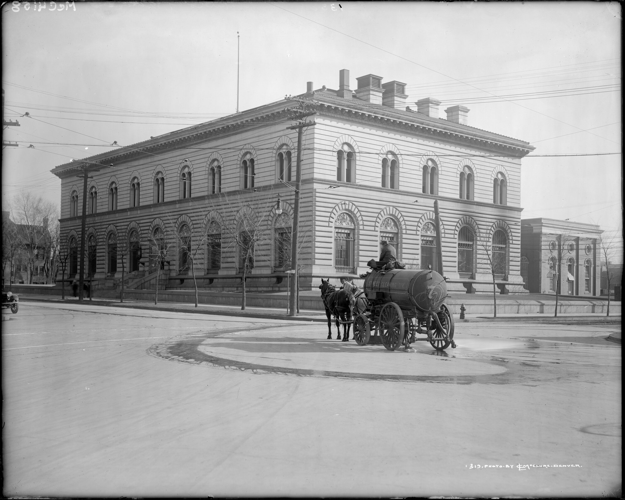
View of a horse drawn street cleaner at Cherokee Street and Colfax Avenue, Denver, Colorado; the United States Mint is in the background. Credit: McClure, Louis Charles, 1867-1957/Denver Public Library Digital Collections
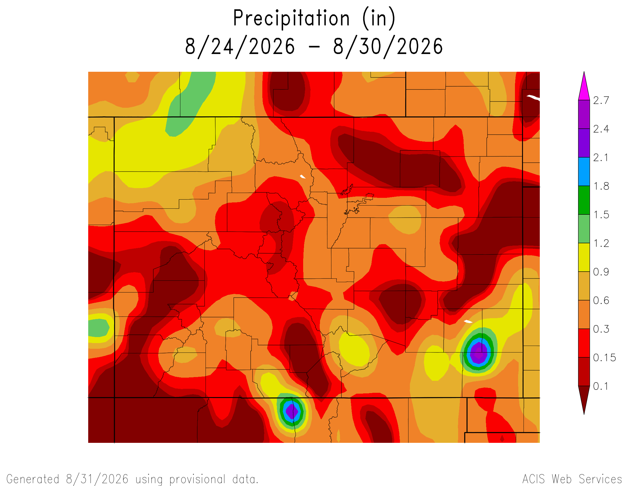
Here’s a look at the 7-Day Colorado precipitation map through August 30, 2026 from the High Plains Regional Climate Center. Precipitation in the South Platte Basin along the Continental Divide of the Americas ranged from 0.10” to 0.30”.
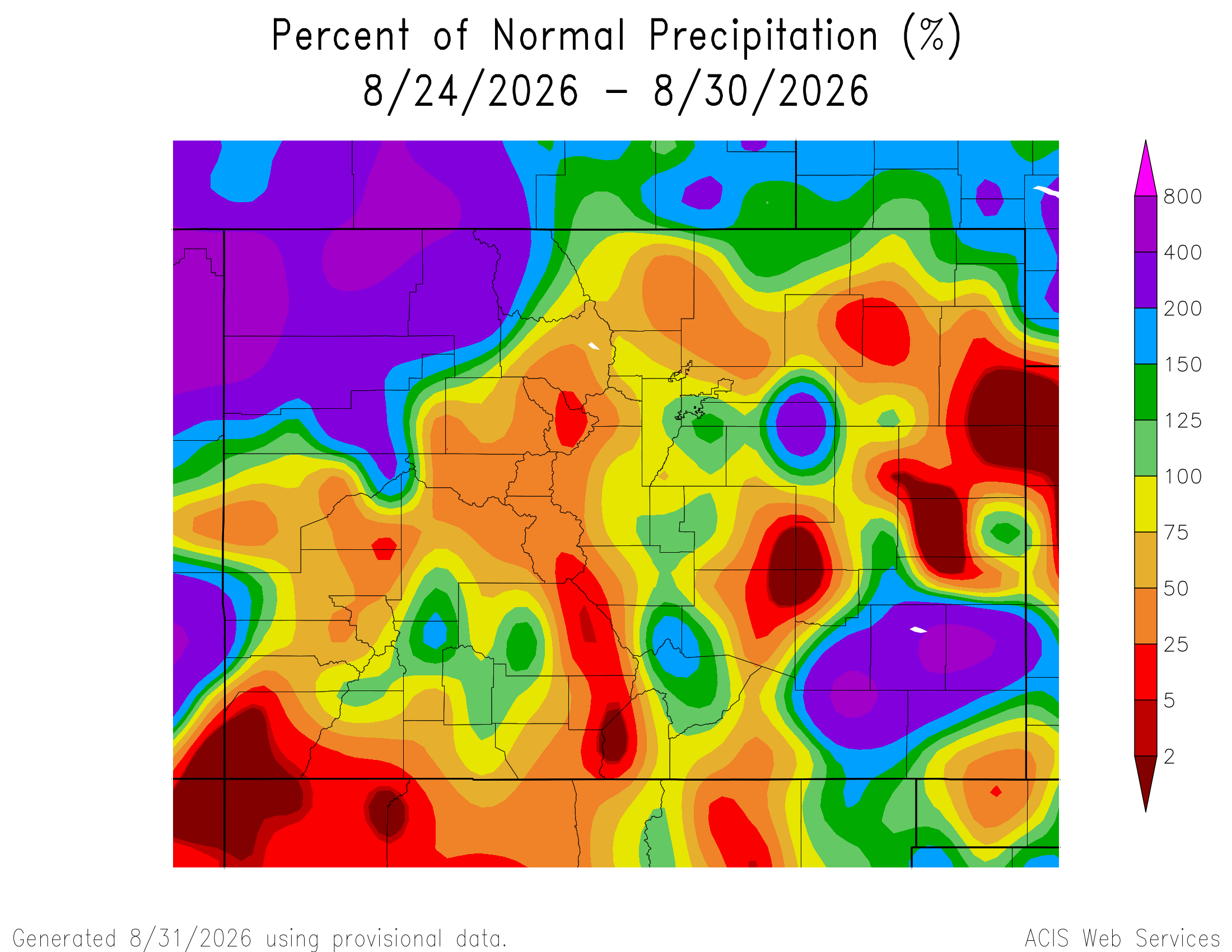
Here’s the 7-Day percent of normal precipitation map through August 30, 2026 from the High Plains Regional Climate Center. Precipitation in the South Platte River Basin along the Continental Divide of the Americas was 5% to 125% of normal.
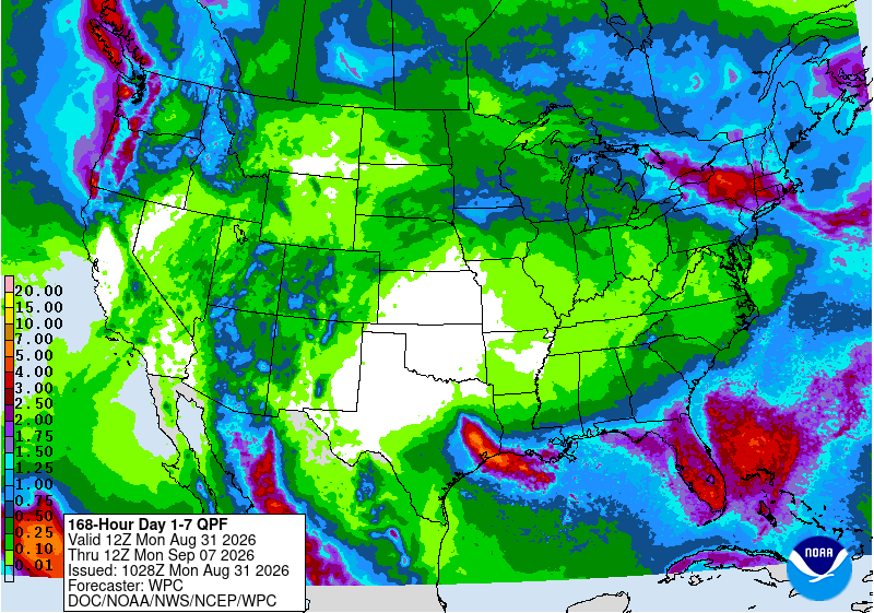
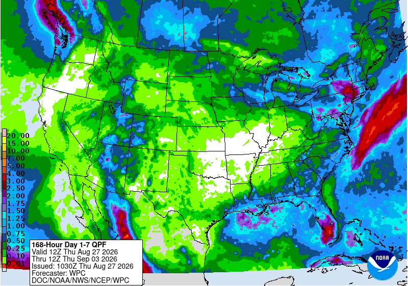
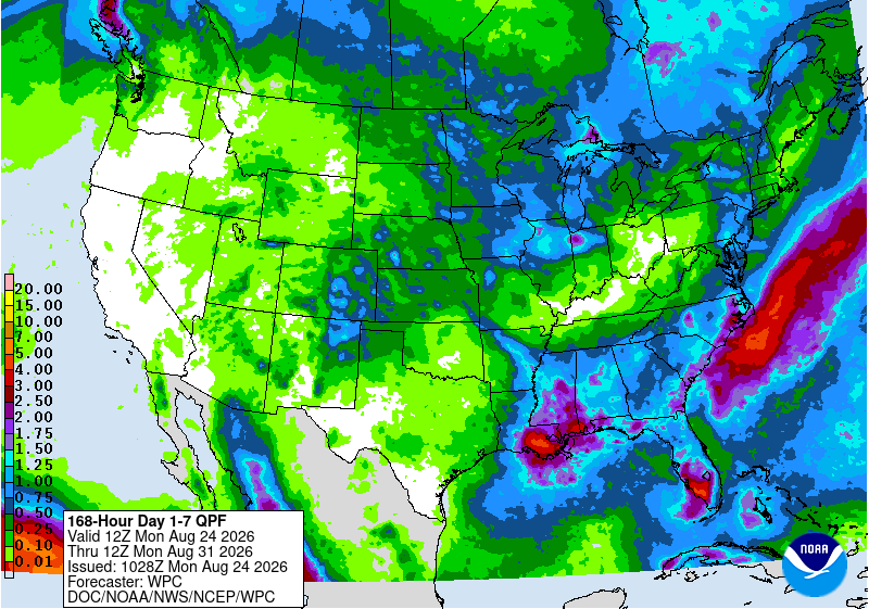
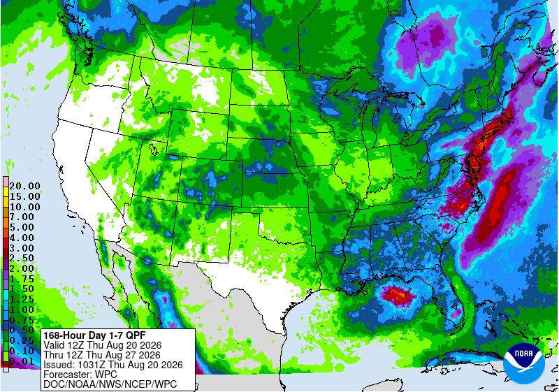
Below is the 7-day Quantitative Precipitation Forecast for the week of August 31, 2026. Precipitation is anticipated for the mountains of the South Platte River Basin and may total up to 0.50″.
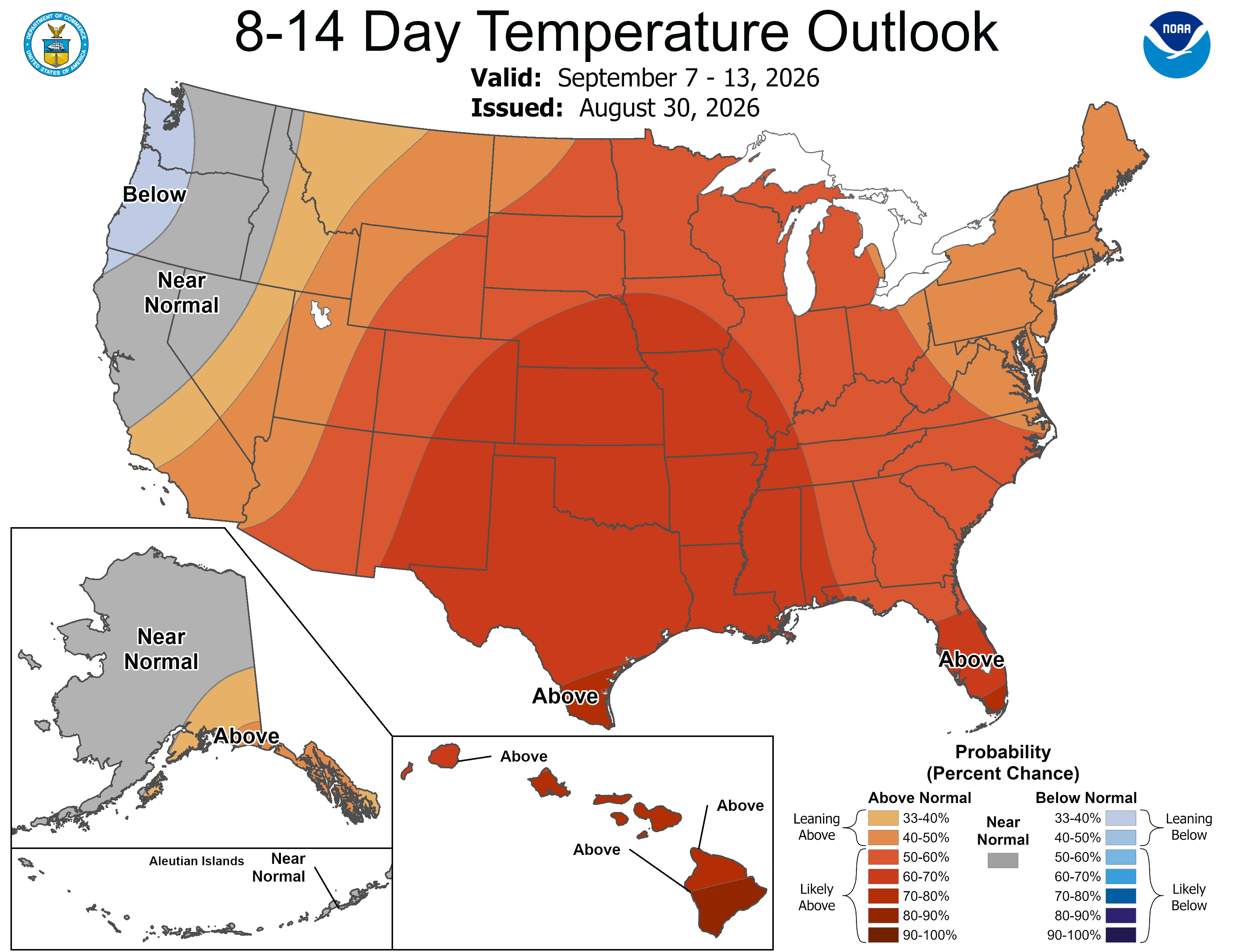
Below are the 8-14 day outlooks from the Climate Prediction Center, issued August 30, 2026, for temperature and precipitation, for the week starting September 7, 2026. The CPC expects above normal temperatures and above normal precipitation for the mountains of the South Platte River Basin.
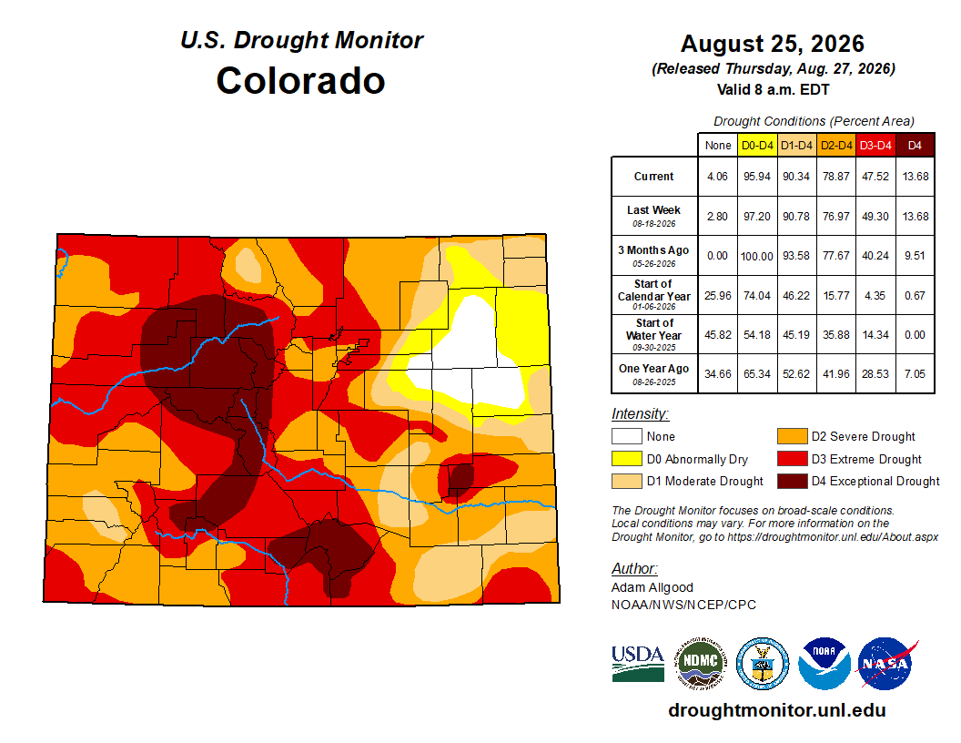
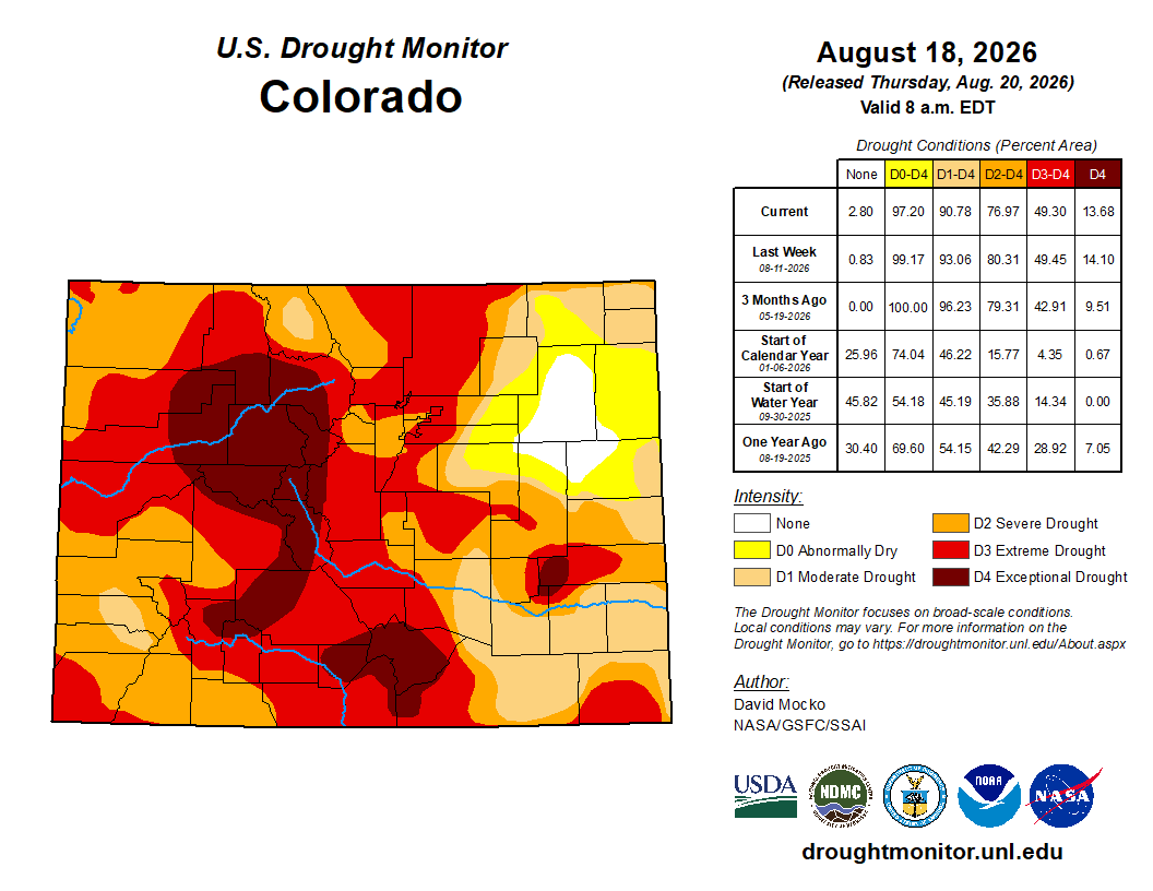
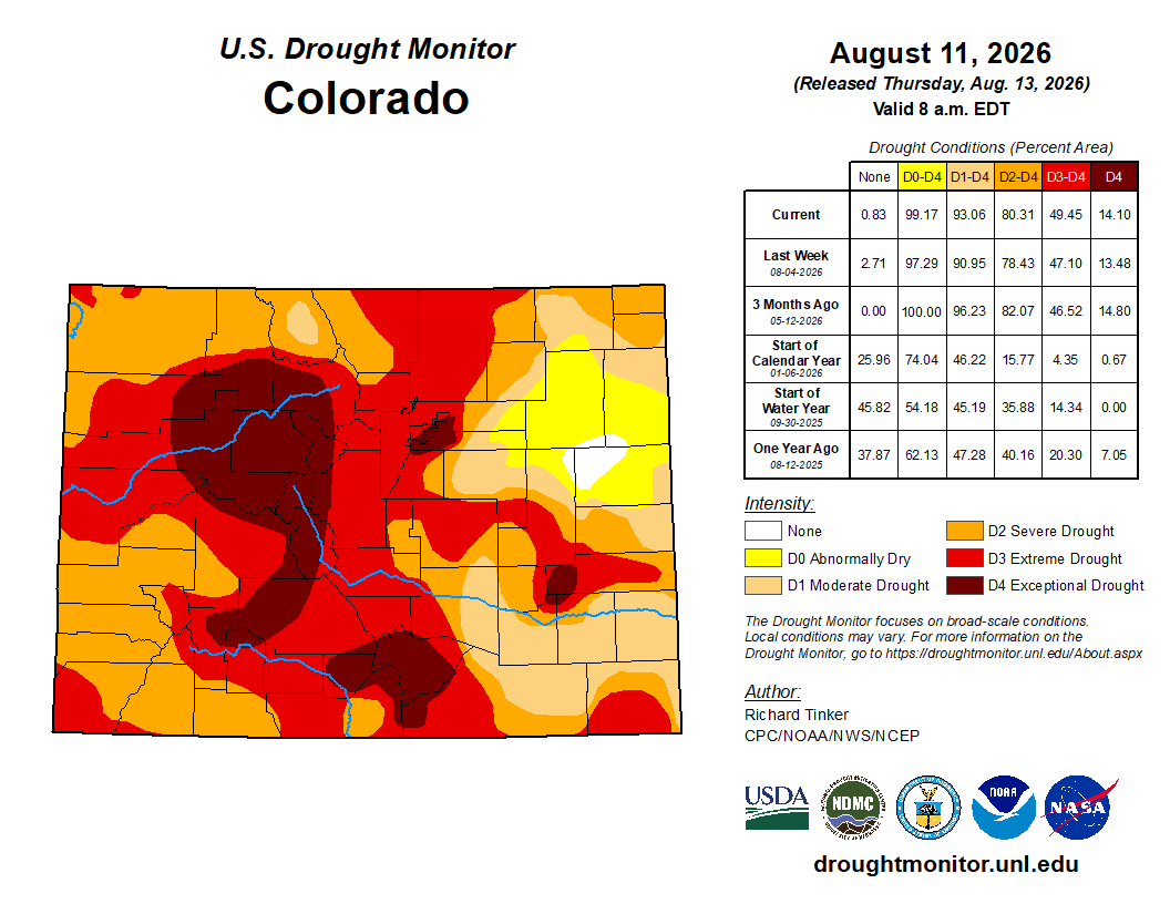
Below is the Colorado Drought Monitor map from August 25, 2026. There were one class improvements in Park, Weld, and Morgan counties. Drought and abnormal dryness covers 95.94% of Colorado. The South Platte Basin is experiencing Abnormally Dry, Moderate, Severe, Extreme, and Exceptional drought conditions.
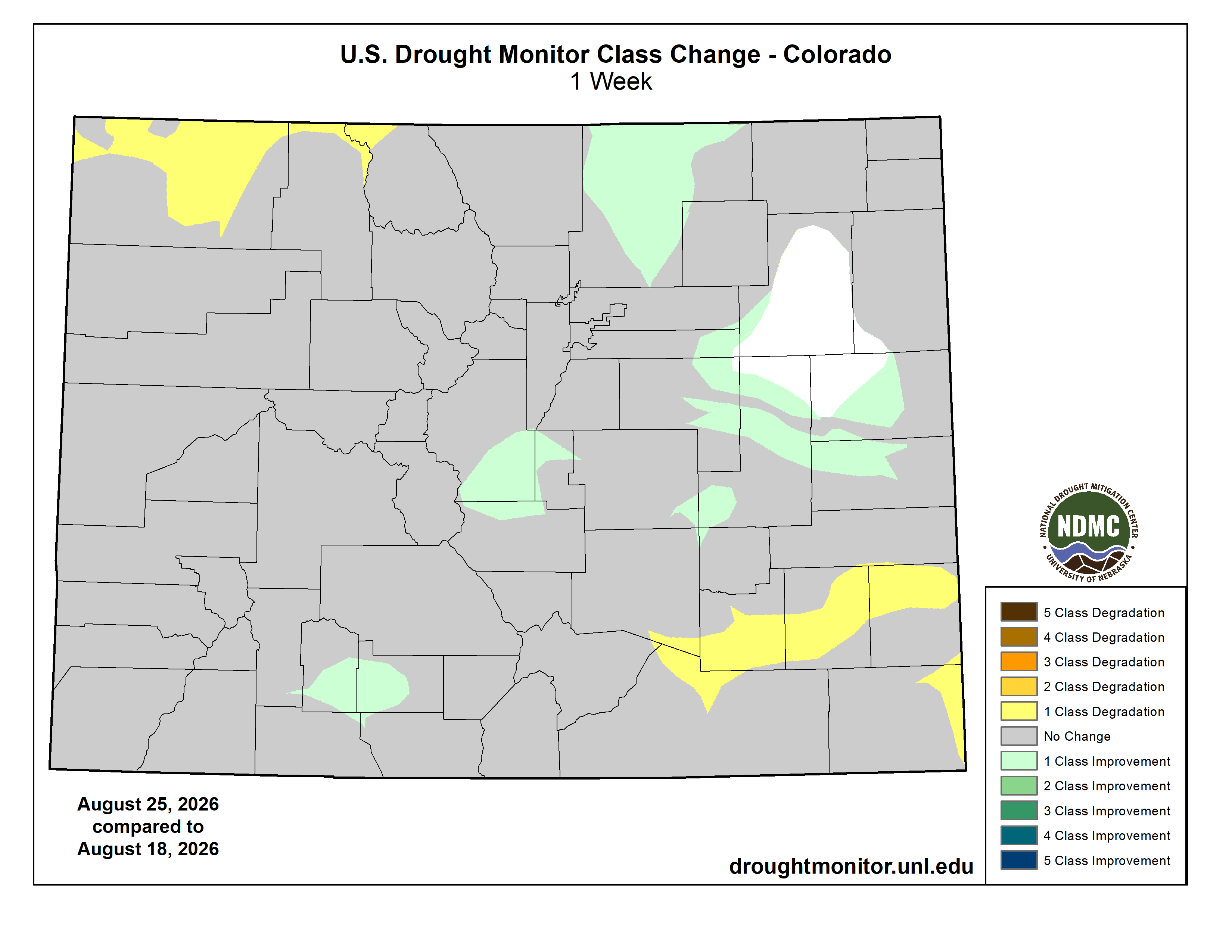
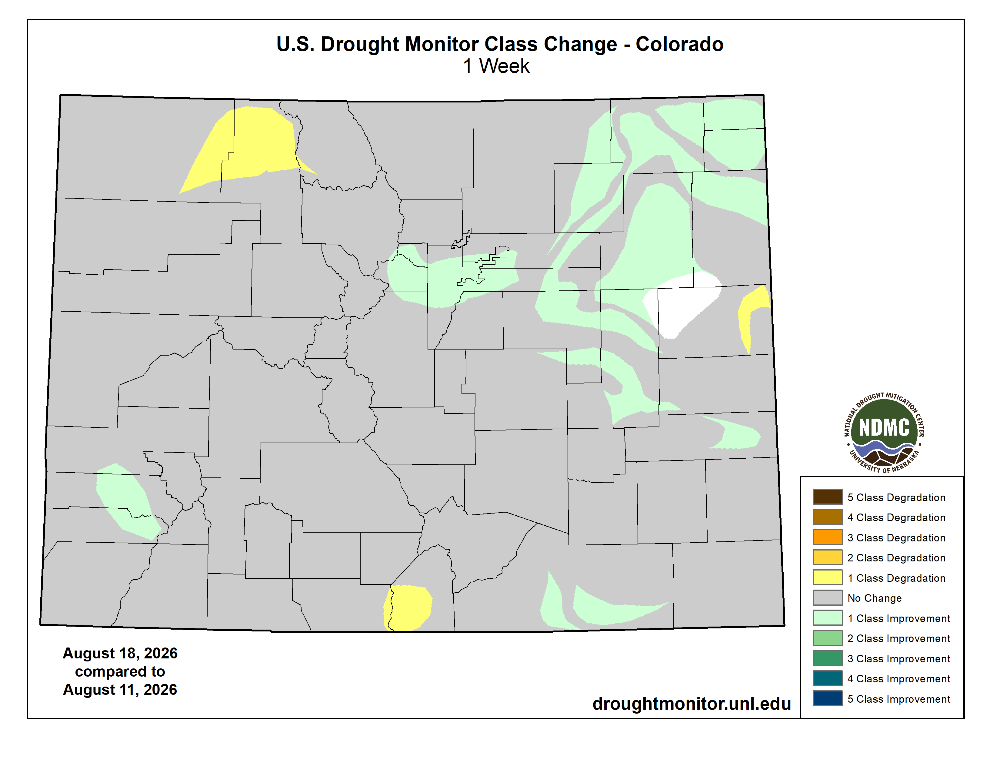
Below is the Colorado Drought Monitor one week change map ending August 25, 2026.
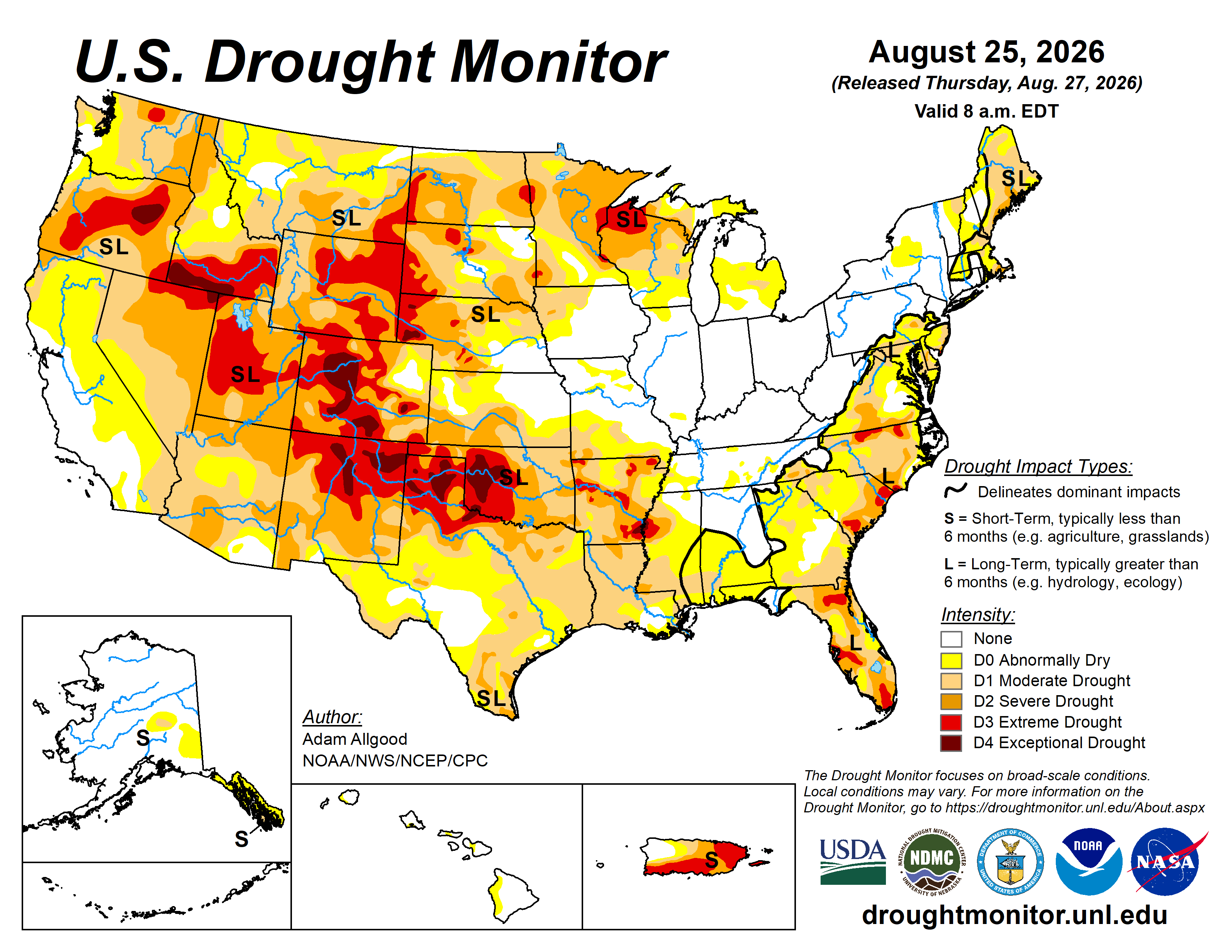
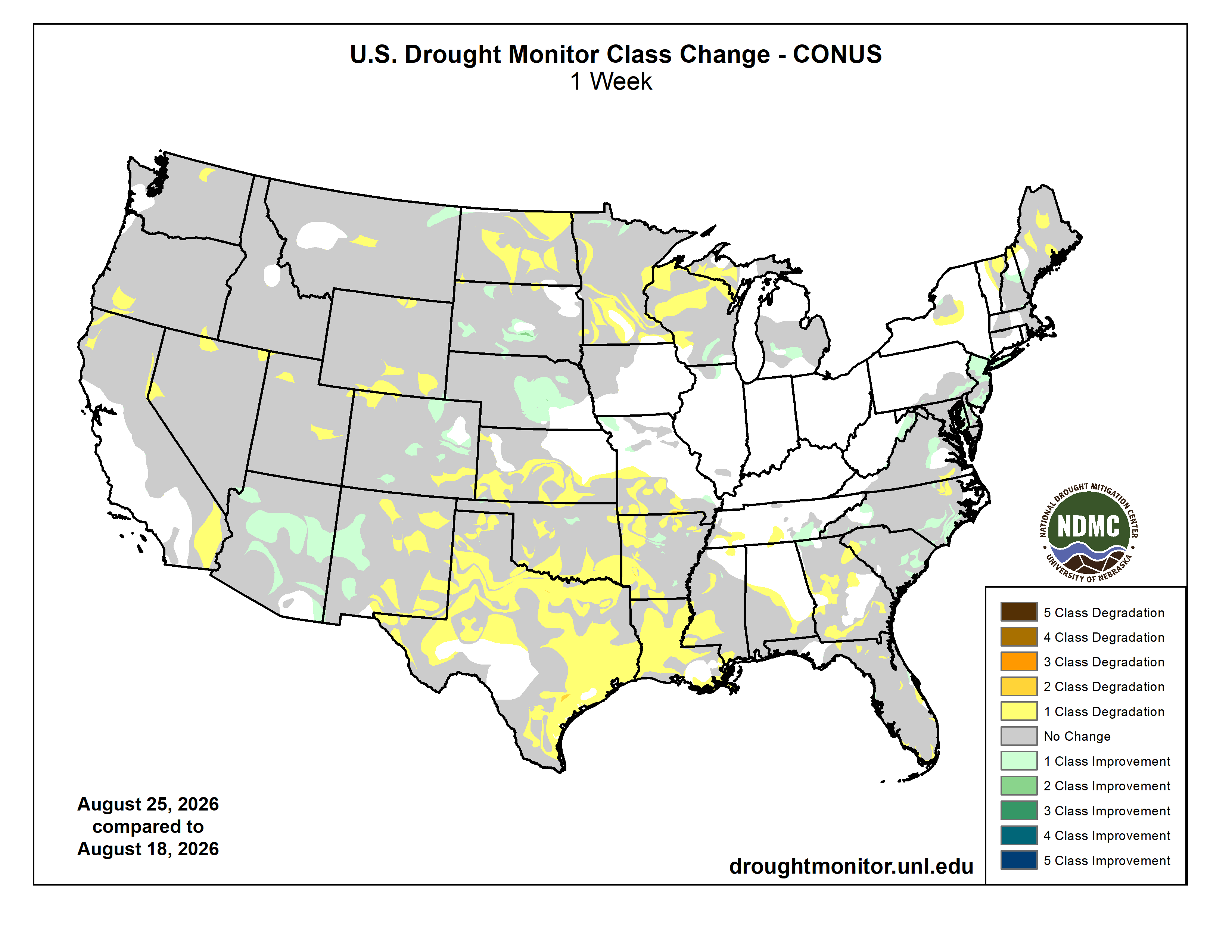
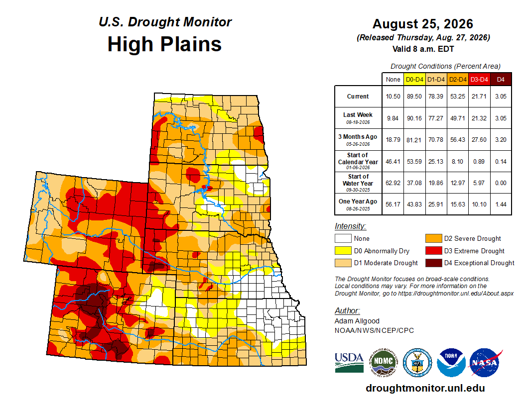
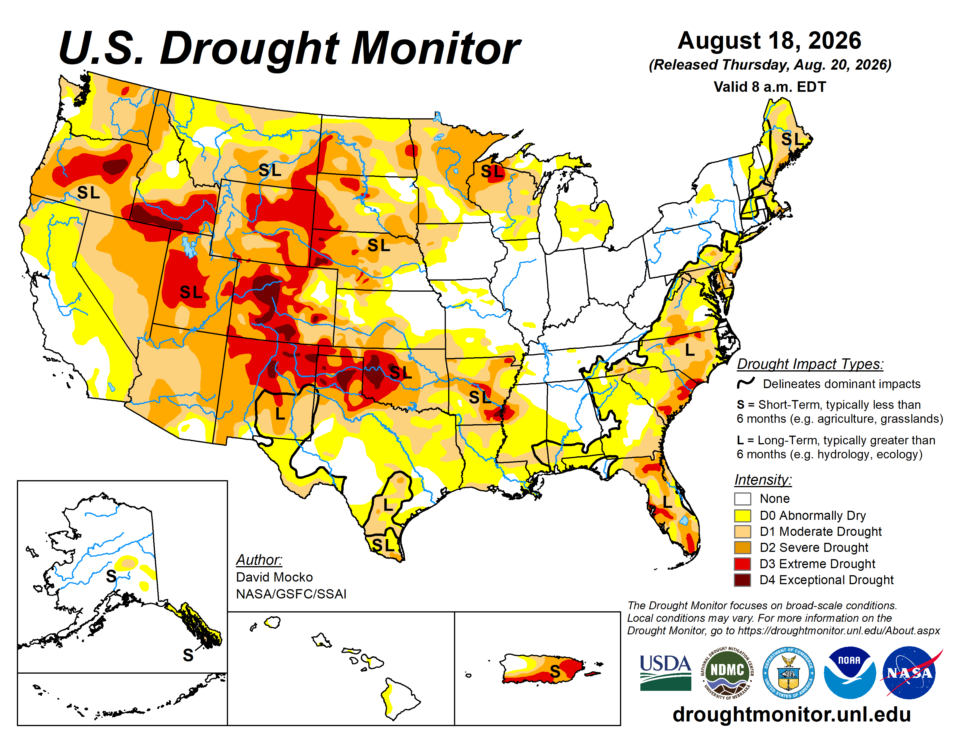
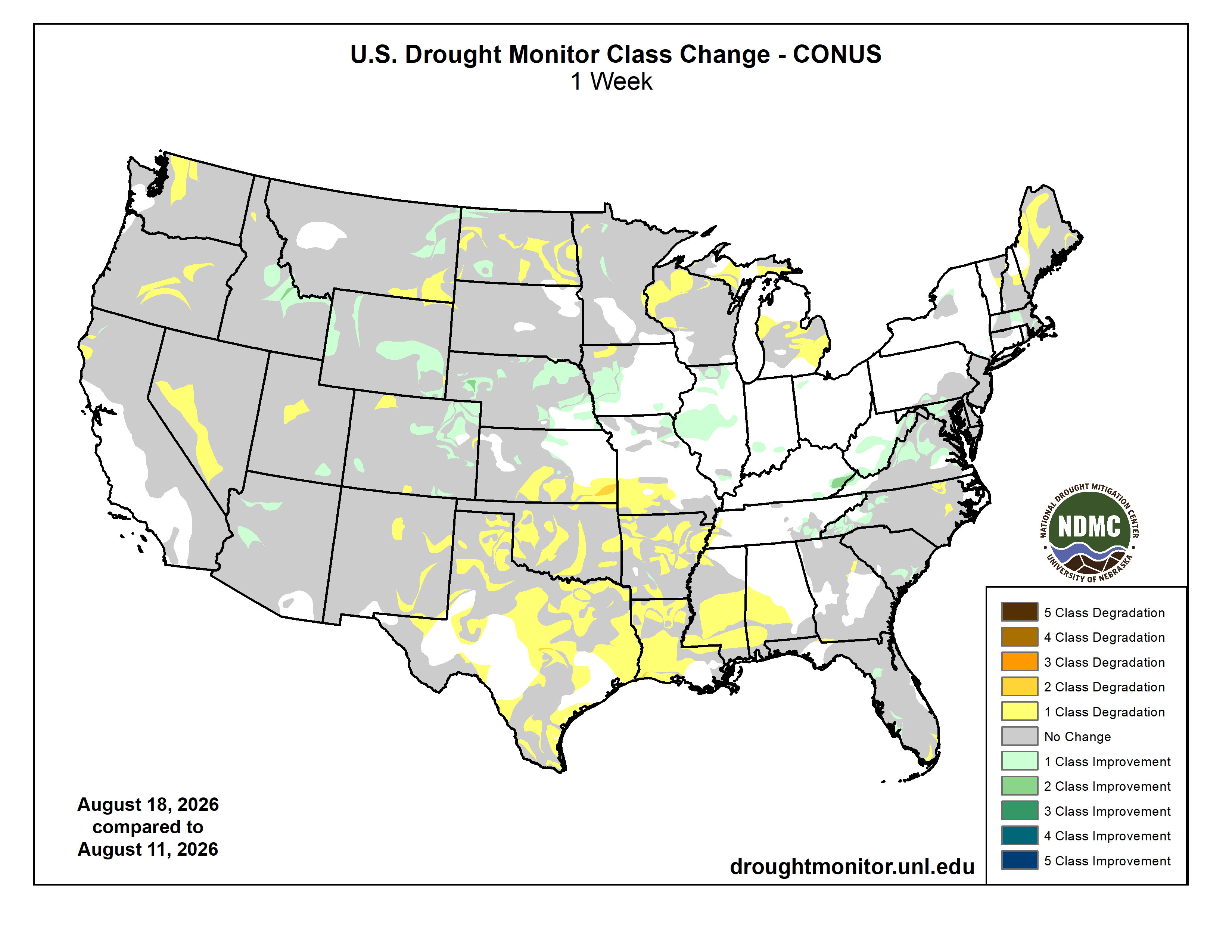
Here’s the US Drought Monitor Map from last week along with the one week U.S. change map.
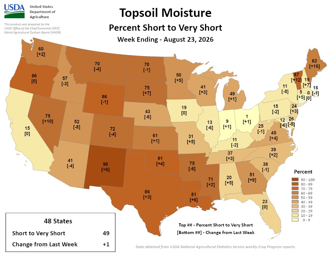
Finally, here’s the Topsoil Moisture Percent Short to Very Short map for the week ending August 23, 2026 from the USDA:
49% of the Lower 48 is short/very short, a 1% increase from last week. Highest short/very topsoil spans parts of the West, Plains, South, and Northeast, led by NM at 90%; VT at 87%; OR, WY, and TX at 86%; and LA and OK at 81%
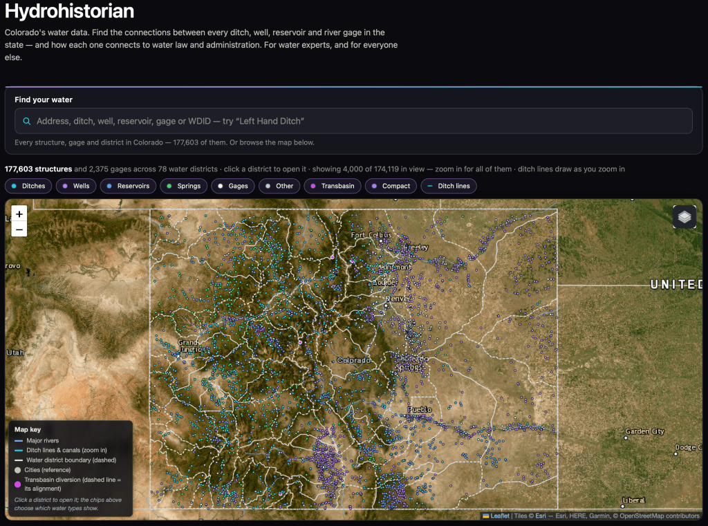
We have met briefly at at least one Colorado water conference (but it’s been a while). I was the Water Resources Analyst at Northglenn for a while, and now am the Water Resources Manager at Consolidated Mutual. But, on my own time, I’ve built something for Colorado water records that may be useful to you or your readers, and I’d rather you see it early. I would appreciate feedback and hopefully some exposure from your organization.
It’s the whole state in one place: all 177,301 decreed structures, 2,271 stream gages, diversion records, water court history, and the calls that administer them, across all seven divisions. Type an address and it shows you the ditches and rights around it. Open any ditch and you get its decrees, what it actually diverted year by year, and where it sits in line. Open a district and you get a straight-line diagram of who takes what, and where.
The piece I’m proudest of went live this week: for any structure, on any day, how much of its decree was actually in priority. Not whether a call was on — how many cfs of that particular ditch’s decree was in priority, counted by the hour, running back through the call record to 1950. I don’t know of anywhere else you can get that without building it yourself.
And it shows its work. Where DWR publishes its own day-by-day out-of-priority analysis, the page scores itself against DWR live, on the page: 98.7% agreement across about 86,000 structure-days, and it lands on DWR’s exact percent-of-day 90.9% of the time. Every page also states plainly what it can’t tell you. I’d rather your readers see the error bars than trust me.
A few things a reader could do with it in five minutes: find out whose ditch runs behind their house; see how many days their ditch was out of priority in the 2002 and 2012 droughts; or watch a senior downstream call reach up a tributary and shut off juniors sixty miles away.
I’d genuinely value your eye on it, and if you think it’s worth a mention to your readers, that would mean a lot. Happy to give you a walkthrough, or to run a specific question against the data if it would make a better post.
— John Crawford
(Water Resources Manager, Consolidated Mutual Water Company), but working independently on this project hydrohistorian.com.
Milkweed, sweet peas, and a plethora of other flora billow from Farmer’s Ditch in the North Fork Valley of western Colorado. Jonathan P. Thompson photo.
It seems like every time the Colorado River and other Western water woes make national headlines, some pundit — usually from the East Coast — weighs in with their “simple” or “obvious” solution. And I get mad and start throwing things around the room, then type out some blistering rant riddled with epithets and insults.
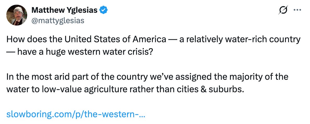
Well, the Colorado River is in the news again, and with it have come the usual swarm of oversimplified hot-takes. The one that really got my goat this time is from Matthew Yglesias, who wrote a piece headlined: The Western water crisis has a simple solution: Stop giving the majority of the water away to farmers for almost nothing!
These things piss me off so much not because they’re wrong, but because there is no “simple” solution to the Western water crisis. That’s because the crisis itself isn’t simple, and saying that it has simple fixes implies that the folks who have spent a lot of time trying to solve the problem are a bunch of idiots, since they hadn’t come up with this solution already. It seems as if Yglesias and his ilk assume that the West is not only monolithic, but that we Westerners are a bunch of backwoods bumpkins who don’t understand the region’s own problems.
Who cares what these bozos believe, right? Right. But judging by the comments on Yglesias’ social media posts, a lot of other people are similarly deluded. So I figured his piece provides a nice opportunity to clear some things up.
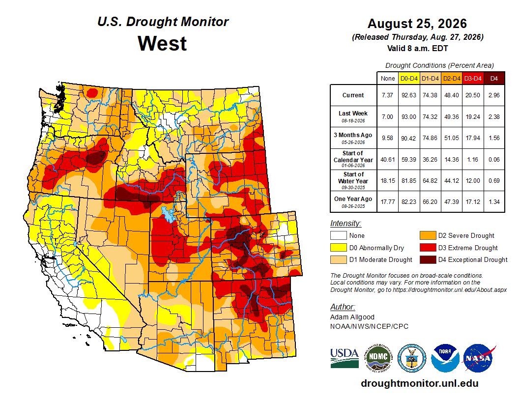
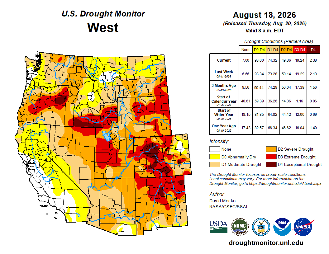
West Drought Monitor map August 25, 2026
In fact, there is no single “Western water crisis.” The West is huge and is geographically, hydrographically, and ecologically diverse. While most, but not all, of the Western U.S. is in some stage of drought currently, not all of those places are experiencing a water crisis, per se. There is a Colorado River water crisis and a Rio Grande water crisis and a San Joaquin Valley water crisis, but those crises are not all the same.
The Colorado River crisis is multifaceted and manifests in different ways in different places and on different levels. The river itself is in crisis, in that stretches of the mainstem and its tributaries virtually dry up during summers like this one. Its users are facing a potential crisis, i.e. looming shortages, as in some of them are getting less water from the river than they did in the past. And the vast and complex plumbing system and legal framework that has been built up to harness and govern the river is perhaps facing the most immediate crisis: It is collapsing under its own weight and in many ways has become obsolete. Each of these is a distinct calamity, with its own twists, turns, causes, and bevy of potential solutions.
From his perch in the Northeast, however, Yglesias sees just one dimension, writing in the “nut graf” of his piece:
Uh, not quite.
Yes, irrigated agriculture is by far the dominant consumer of Colorado River water, accounting for 52% of overall consumption and 74% of direct human consumption. And yes, agricultural users typically and notoriously pay less for the water than municipal users. No, this is not dictated by federal law.
Agricultural users were among the first entities in the colonial-settler era to put large quantities of water to beneficial use, giving them the most senior rights to the largest quantities of water. The Imperial Irrigation District, for example, has senior rights to about 3 million acre-feet of Colorado River water, most of which is used for agriculture.
These water rights holders have a legal right to use a set amount of water each year. They are not leasing or purchasing the water from the federal government or anyone else. It’s essentially theirs, for free, as long as they are able to divert it from the river and put it to beneficial use.
San Luis People’s Ditch March 17, 2018. Photo credit: Greg Hobbs
Usually the water rights are held by irrigation districts, ditch companies, municipalities, corporations, or, in some cases, very large individual landholders. In the late 1800s, these entities built their own diversions, canals, and delivery systems. Construction was often financed by private investors and the individual irrigators, who held stocks, or shares, in the ditch company. Each share would entitle its holder to a set amount of water from the canal. The shareholder would pay an annual fee for each share to cover construction, maintenance, and operating costs.
The Bureau of Reclamation was established in 1902 to build larger scale dams, diversions, and canals to deliver water to users and to spur agricultural development in the arid West. Call it the nationalized version of an irrigation district, but on steroids. The federal government paid for the projects, but the irrigation districts and municipal water utilities they served were expected to pay back the costs over time. The taxpayers supposedly wouldn’t have to pay a dime. Yet as the years went by, and as the budgets of the projects skyrocketed, the terms of the paybacks were relaxed, especially for agricultural users. This effectively subsidized water delivery, which in turn lowered farmers’ costs.
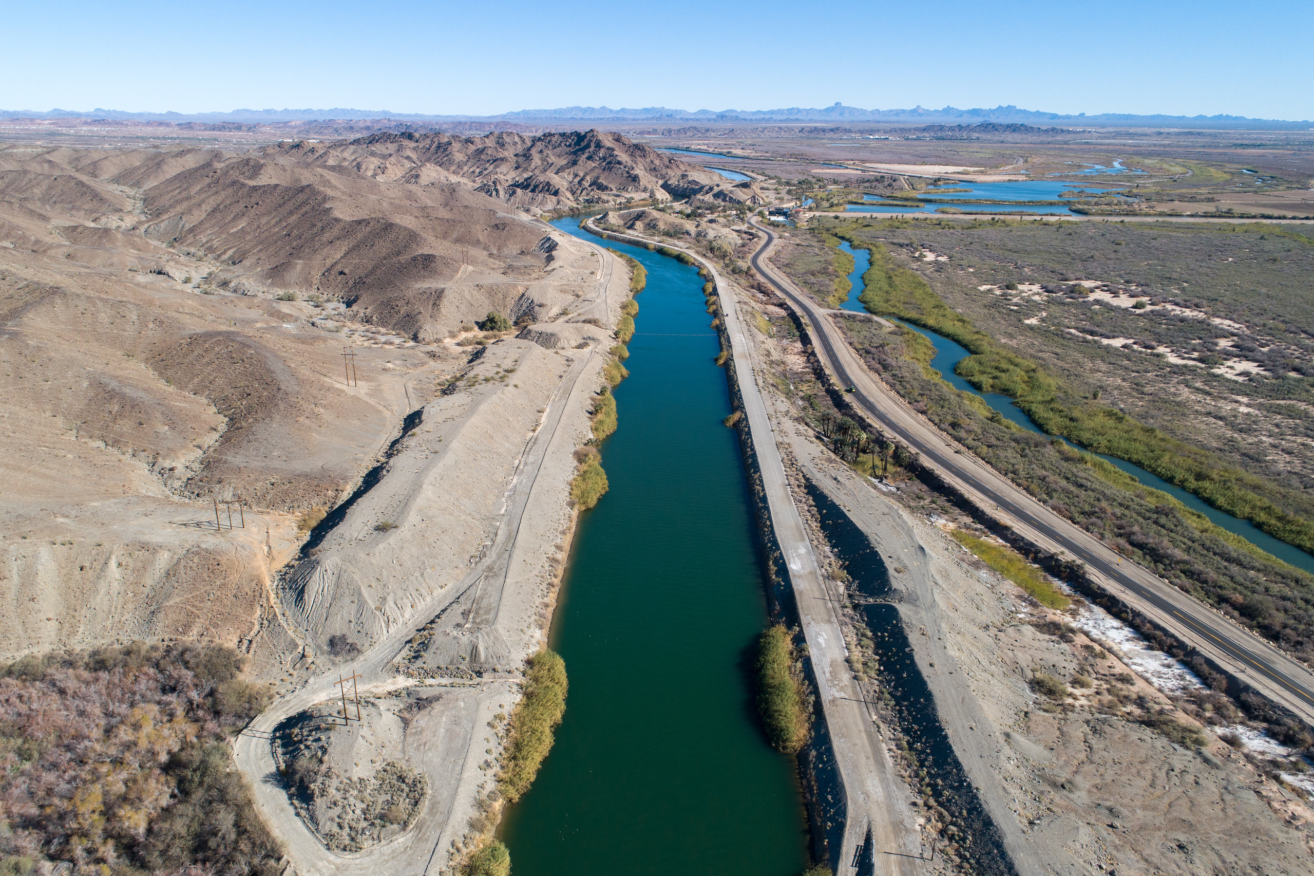
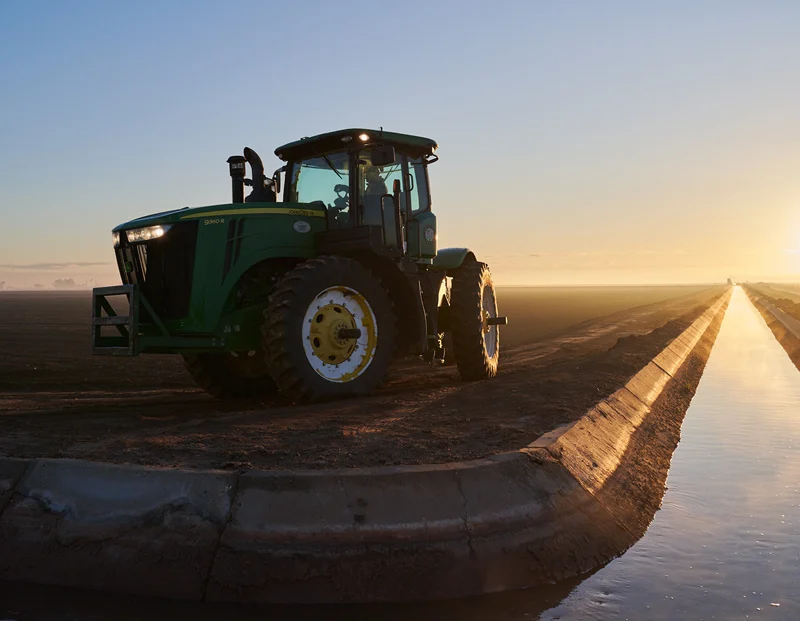
The All American Canal, the largest diversion on the Colorado River, passes through Winterhaven, CA on its way to the Imperial Valley. The Colorado River is seen flowing next to it.
One of the Bureau’s big projects was the 80-mile-long All-American Canal, built in the 1930s to ferry Colorado River water to the Imperial Irrigation District and other users. The IID entered into a 50-year payback contract, which ended in 1994. The Bureau still owns the canal, but the IID operates and maintains it and other infrastructure that delivers Colorado River water to nine cities and some 500,000 acres of farmland.
The IID pays nothing for the Colorado River water itself. It does pay to operate and maintain its vast water delivery system, and offsets those costs by charging agricultural and municipal users just $20 per acre-foot for water it delivers, a bargain basement rate. In other words, Imperial Valley farmers do get cheap water, but so do Imperial Valley cities and even industry (which pays $85/af, also relatively affordable). IID also brings in about $160 million annually by selling water to the San Diego County Water Authority. The operating costs for the All-American Canal system are lower than, say, the Central Arizona Project’s, because the All-American Canal is gravity fed, whereas the CAP uses huge amounts of electricity to pump water uphill.
Similar setups exist across the Colorado River Basin. But each system is distinct, and each has its own mix of federal and private funding and operational scenarios and rates.
And here’s one of the main flaws of Yglesias’s argument: He assumes that there’s some all powerful actor out there that sets rates and standards for water from the Colorado River, although he himself clearly doesn’t know who or what that actor is (he always uses the passive voice, or the all-encompassing “you” in these cases). That’s because that entity doesn’t exist. While the feds could stop subsidizing agriculture, and should not build any more water projects, they don’t have the authority to step in and adjust water rates. States probably could set rates for groundwater, but they can’t charge the IID for exercising their water rights on the Colorado River.
Next, Yglesias pivots to pillorying alfalfa, because that’s in vogue these days. I’m not going to get into that too much, because I’ve written about it so many times here before, but this little bit is pretty funny:
Now, I’m no alfalfa apologist (nor am I an alfalfaphobe), but I feel like I should point out that most of the alfalfa grown with Colorado River water is used to feed dairy cows, which in turn produce milk and cheese and ice cream. Unless Yglesias is a vegan, he might want to consider that. He then argues that since alfalfa is relatively low-value (money wise) compared to Las Vegas casinos, Phoenix microchip factories, or housing, the water should be going to casinos, factories, and housing, not farms, which would presumably happen if farmers had to pay more for water (i.e. they’d go broke and be forced to sell).
First off, there is nothing novel or groundbreaking about this idea. Sprawl has been gobbling up farmland, and water rights, for decades in the West. Phoenix didn’t just grow into the desert, it also grew into citrus orchards and alfalfa fields, and will probably continue to build housing and data centers on what ag land remains. A different version of this concept, where a city or developer purchases a farmer’s water rights, but uses them somewhere else — a practice known as buy and dry — is also not uncommon.
This does not solve the water crisis. Instead of cutting consumption, which is what’s needed, it merely shifts the consumption from one use — agriculture — to other ones, such as housing and golf courses and chip manufacturing and data centers. This may wring more cash out of each acre-foot of water, but it doesn’t lower consumption. An acre-foot is an acre-foot, whether it’s going to alfalfa, a golf course, a neighborhood’s lawns, a data center or a swimming pool.
Besides, transitioning land out of agriculture comes with its own problems. We can argue forever about whether farming alfalfa or any other crop in the desert is appropriate, or of adequately high value, or whatever. We can argue that the Bureau of Reclamation should never have existed, and that irrigating the arid West should have been left to private entities operating in a free market. But the fact is, there is farming in the desert, those projects did end up subsidizing the agriculture industry, and communities, economies, cultures, and even new landscapes have emerged from and formed around those farms.
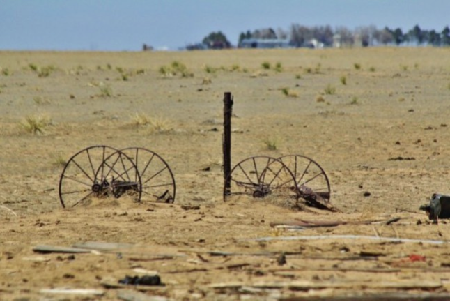
Photo of Crowley County by Jennifer Goodland
Taking vast swaths of land out of farming, whether to build houses or solar panels or to buy the water rights and use them somewhere else, has myriad consequences, many of them negative. Fields can become noxious-weed-clogged dust pits, the wildlife and ecosystems that have come to rely on irrigation runoff dry up, farm workers and families and the businesses that rely on them are displaced, communities’ economies are upended. As Madeline Wilson, an agricultural systems specialist for Colorado State University’s extension office pointed out at a 2024 panel on dust-on-snow, every field fallowed in the San Luis Valley for conservation purposes also represents a family. “We’re not just talking about drying up lands,” she said, “but the drying up of our economy.”
In no way does this mean that farms should be immune from curtailment. Indeed, because agriculture is the biggest user of Colorado River water, it will have to take the largest cuts in consumption. There is simply nowhere else from which the 4 million acre-feet or more of reductions per year needed to bring demand into line with dwindling supplies can come. But forcing farmers into bankruptcy by jacking up water rates (if there was a mechanism to do so), or prescribing “incredibly simple” policy solutions that don’t consider the complexities of the situation and its myriad moving parts or the on-the-ground impacts, isn’t the way to do it.
Udall/Overpeck 4-panel Figure Colorado River temperature/precipitation/natural flows with trend. Lake Mead and Lake Powell storage. Updated through Water Year 2025. Note the tiny points on the annual data so that you can flyspeck the individual years. Credit: Brad Udall
The “root cause” of the Colorado River crises is not alfalfa or pecans or cotton or cattle, it’s not the prior appropriation doctrine or the low price of water, it’s not overpopulation, it’s not data centers or golf courses or lawns or bad forest management or lack of or too many reservoirs. The root cause is twofold. First, there’s scarcity. The Southwest is an arid place, and climate change-exacerbated warming is drying it out more: there is less precipitation; the precipitation we do get is falling as rain, not snow; the snow we get is melting faster; and evapotranspiration is happening at a higher rate. This all leads to less water in the streams, reservoirs, rivers, and even aquifers. Secondly, there’s the chronic and long-term failure to acknowledge the scarcity, and the stubborn refusal to adapt to it and adjust consumption accordingly.
Consumptive use of Colorado River water for the Lower Basin’s largest users over time. Source: Bureau of Reclamation.
There has been progress. Over the last two decades some of the biggest water users on the river have slashed their water use considerably, sometimes because they had no choice, in some cases because they were incentivized to do so, and in other cases they did it to get ahead of future cuts. Last year, for example, the Imperial Irrigation District used 900,000 acre-feet less than it did in 1999. By its count, it has conserved over 9 million acre-feet since 2003 by fallowing fields and deploying various efficiency measures. And yet they’ve done so while continuing to grow nearly $240 million worth of alfalfa annually. It will need to do more; everyone will. But it’s a pretty big start.
There is one simple solution to the Colorado River crises: Everyone on the river has to use less water. Period. This won’t come from pithy policy prescriptions or one-dimensional solutions. It will require the tribal nations, the states, and all of the water users in the basin to come together and find a new way to approach and think about and revere the lifeline of the Southwest.
Coming in September: The Land Desk News Feed! This will be a once-a-week roundup of the West’s most important headlines, journalism, and commentary, curated and summarized by yours truly. I’m thinking it will probably drop on Wednesdays, but haven’t settled on anything, yet. Most weeks it will come in addition to the regular two Land Desk dispatches, but some weeks it may take one of the others’ place (meaning you’d only get two newsletters that week so as to not clog up your inbox all the time!).
All paid and free subscribers should expect the first edition on Sept. 9.
📸 Parting Shot 🎞️
Church and Cerro Pedernal, Youngsville, NM. Jonathan P. Thompson photo
Click the link to read the article on the InkStain website (Karl Flessa):
August 20, 2026
In the classic Monty Python sketch, a customer returns to the pet shop where, just 30 minutes ago, he purchased a parrot. He complains that the parrot is dead. The shopkeeper tries to convince the customer the parrot is only resting or is stunned.
In the ensuing argument, the customer uses no fewer than eighteen euphemisms: “This parrot is definitely deceased…demised…passed on…no more…ceased to be…expired…gone to meet his maker…a stiff…bereft of life…rests in peace…pushing up the daisies…metabolic processes are now history…off the twig…kicked the bucket…shuffled off his mortal coil…run down the curtain…joined the bleedin’ choir invisible.”
Indeed, the parrot was nailed to its perch, already dead when the customer bought it.
The Compact and its subsequent agreements are as dead as that parrot.
The Compact is dead because it is founded on a false premise: a river that can produce the prescribed amount of water.
The Compact is dead because it is unjust: neither the Tribes nor nature participate in negotiations.
The Compact is dead because it doesn’t work. The Basin States are locked in battle; the Federal government tinkers and dithers.
In the longer version of the sketch, the shopkeeper goes to the back in search of a live replacement, returning to report “…we’re right out of parrots.”
So are we.
We need a new Compact.
Proposals are not lacking: proportional allocations, Tribal standing, a whole-basin approach, adjustments based on actual flows, a basin authority, nature’s fair share, interstate trading… .
What’s lacking is the courage to change. [ed. emphasis mine]
The Compact is a dead parrot.
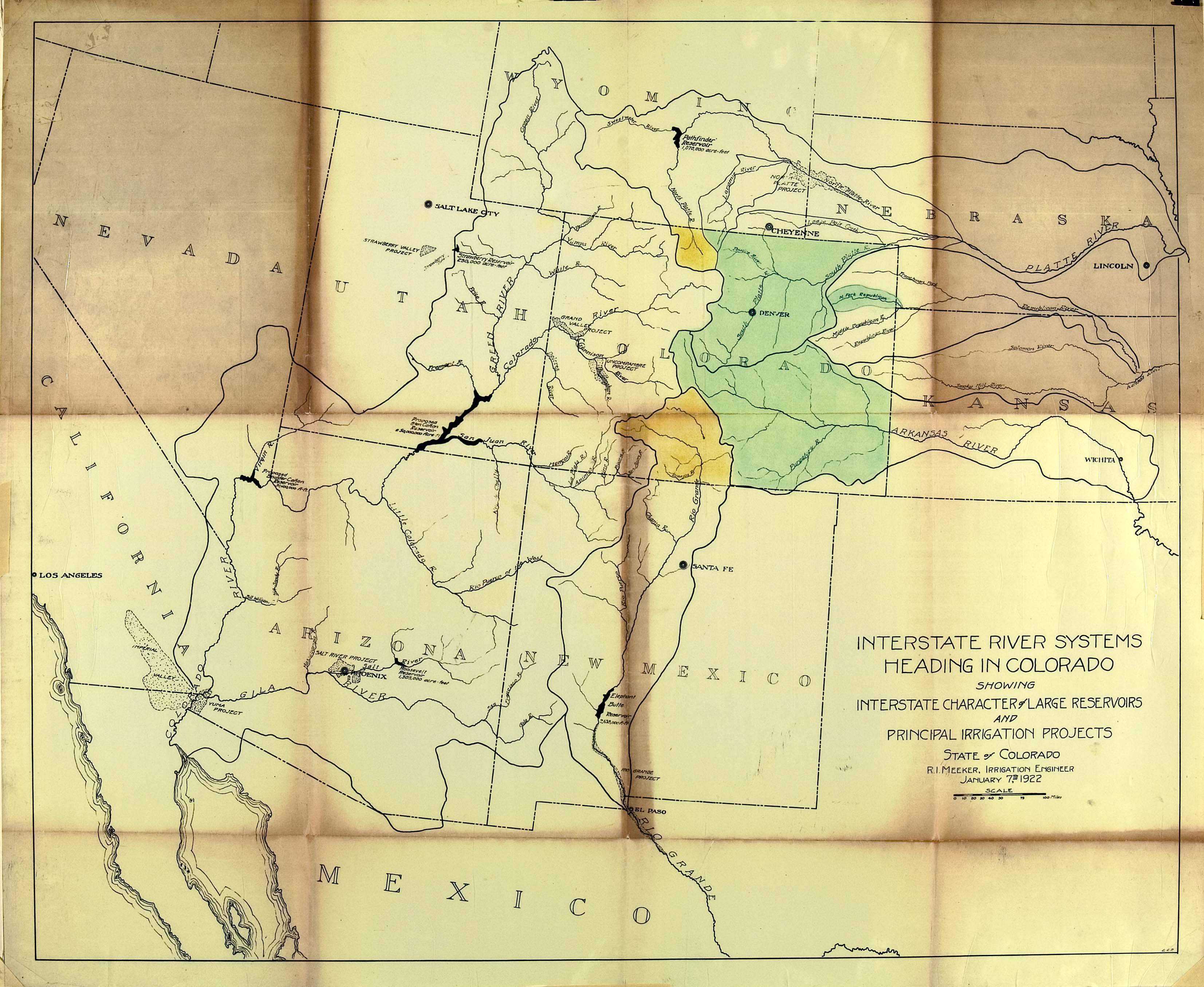
Delph Carpenter’s original map showing a reservoir at Glen Canyon and one at Black Canyon via Greg Hobbs
At its Aug. 17 meeting, the San Juan Water Conservancy District (SJWCD) Board of Directors moved forward with contracting engineering firm RJH Consultants to perform a water demand study for the district’s reservoir project. SJWCD board president Randy Cooper opened discussion of the study by summarizing the history of the study, which the board delayed approving at its last meeting since board treasurer Joe Tedder was not at the meeting and had not had an opportunity to review the contract. He explained that the $147,400 cost of the study would be split between 2026 and 2027, which RJH had agreed to. In response to a question from Tedder, Cooper stated that RJH would be ready to start work on the study immediately upon board approval…The board agreed that RJH should provide monthly updates on the project to ensure that the project adapts to any changing circumstances or barriers the district encounters, which Jones raised concerns about.
Map of the San Juan River, a tributary of the Colorado River, in Arizona, Colorado, New Mexico and Utah, USA. Made using USGS National Map data. By Shannon1 – Own work, CC BY-SA 4.0, https://commons.wikimedia.org/w/index.php?curid=47456307
The Pagosa Area Water and Sanitation District (PAWSD) Board of Directors heard an update on drought conditions and continued discussions of violation enforcement at its Aug. 13 meeting…PAWSD is currently in drought stage two of its four-stage drought management plan. PAWSD District Manager Andrew Connor stated that PAWSD currently has “really good compliance” and saw a drop in water sales in July, meaning that public education is working, even if revenues for the district also decreased…PAWSD board member Glenn Walsh asked if the revenue decrease from lowered water use in July was compensated for by surcharges for high water use, which staff confirmed. PAWSD board member Alex Boehmer commented that, since the district is getting compliance with its regulations, he did not think implementing violation letters and fines is necessary. He added that he would also like to authorize Connor to move the district in and out of drought stages when necessary. Tautges commented that he would only want this authorization for reducing the drought stage and not for increasing it, which should require a board vote.
I drove to the bluff overlooking the “Gunny” to process the sad news — news that hasn’t yet been made official — that by October a big portion of the lower Gunnison River in western Colorado will be dry. The official term is “fully dewatered.”
Monsoons were supposed to be heavy this year. As I looked down at the river in late August, clouds in the distance appeared almost monsoonal. Wisps of rain streamed out, but they evaporated before reaching the parched ground. It just about made me cry.
Below me, the North Fork of the Gunnison unceremoniously trickled into the Gunnison River at a place known as Pleasure Park, a weather-beaten outpost of civilization that’s one of the last best-kept secrets in Colorado.
The Gunnison River starts high in the Elk Mountains and flows into Colorado’s largest body of water, Blue Mesa reservoir, though currently it is only the second largest because of drought. Then it flows free through Black Canyon National Park, but only after most of its water gets diverted to irrigate farmland surrounding the towns of Delta and Montrose. The park is a gem, albeit one of the least visited in the nation. From above there’s not much to do except walk to outlooks to stare at sheer, colorful rock walls on the other side and the thin ribbon of river 2,000 feet below.
The “Gunny” then flows through the remote yet accessible Gunnison Gorge Wilderness. In this thin crack of the earth, I’ve spent the past 12 summers working as a wilderness fly-fishing river guide.
Accessible is a relative term. The hearty few that run this remote wild river get to the water by hiking a rough 1.2-mile-long mule trail that drops steeply for almost 600 vertical feet. Even getting to the trailhead takes an hour and a half from the nearest town, and it’s on a four-wheel-drive road that’s been the death knell of many a low-clearance vehicle. Rocky on a good day, it can become impassable when wet.
For those with the dough, a mule packer can be hired to transport boat and gear to the river. Those with the youth, knees, and determination can backpack down rafts, frames, oars, fishing and camping gear. Even elite guests, including former presidents who book fly-fishing trips with commercial guide services, carry their personal gear down to the river.
World-class fishing is why anybody makes the effort, 14 miles of wilderness Gold Medal water, the action peaking in June when large hungry trout key in on an epic salmon-fly hatch.
This stretch of river may be navigable, but it features 18 named technical rapids, and any one of them can humble experienced river runners. Rapids called “Improvise,” “Boulder Garden,” and “Squeeze” can feel more like rock than water, and almost every rapid has ruined a trip at some point. The river is littered with rocks that also earned names because they have strong personalities: “Queen of Hearts,” “The Table and Tombstone,” and “Dicky Do.” Others carry the monikers of unlucky guides.
All these barriers have kept crowds at bay though now there’s a new constraint — 90-to-100-degree temperatures for days on end. The Gorge can remain runnable in 14-foot rafts down to about 300 cubic feet per second, but even then it’s tight. Today it’s running well below that, and the water is too warm for the fish. Most commercial trips have been canceled.
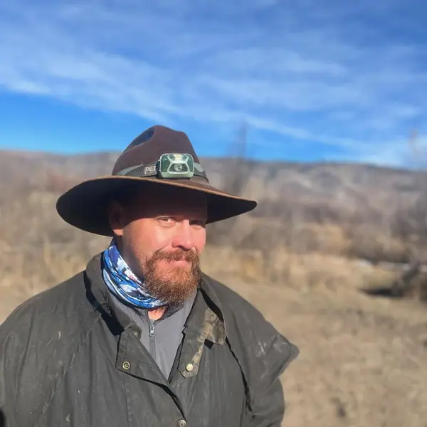
Jacob Richards. Photo credit: Writers on the Range
Looking upriver into the Gorge, I don’t see any boats fishing their way out of the wilderness, and it doesn’t take much to imagine the riverbed — a sad meander of dry cobbles bleached white, punctuated by stagnant pools full of belly-up trout.
This place, with its rugged remoteness, wild rapids and world-class trout fishing, has carved its way into my soul. I mourn for future generations who will probably know a much different river.
I feel bad for the salty guides out both trips and tips. I mourn too for the bugs that fattened the fish that paid my bills, for the mergansers, ring-tail cats and desert bighorn sheep. All need a river that’s wet.
Jacob Richards is a contributor to Writers on the Range, an independent nonprofit dedicated to spurring lively conversation about the West. He is a writer about Western environmental issues and sometime outdoor guide. He lives in Fruita in western Colorado.
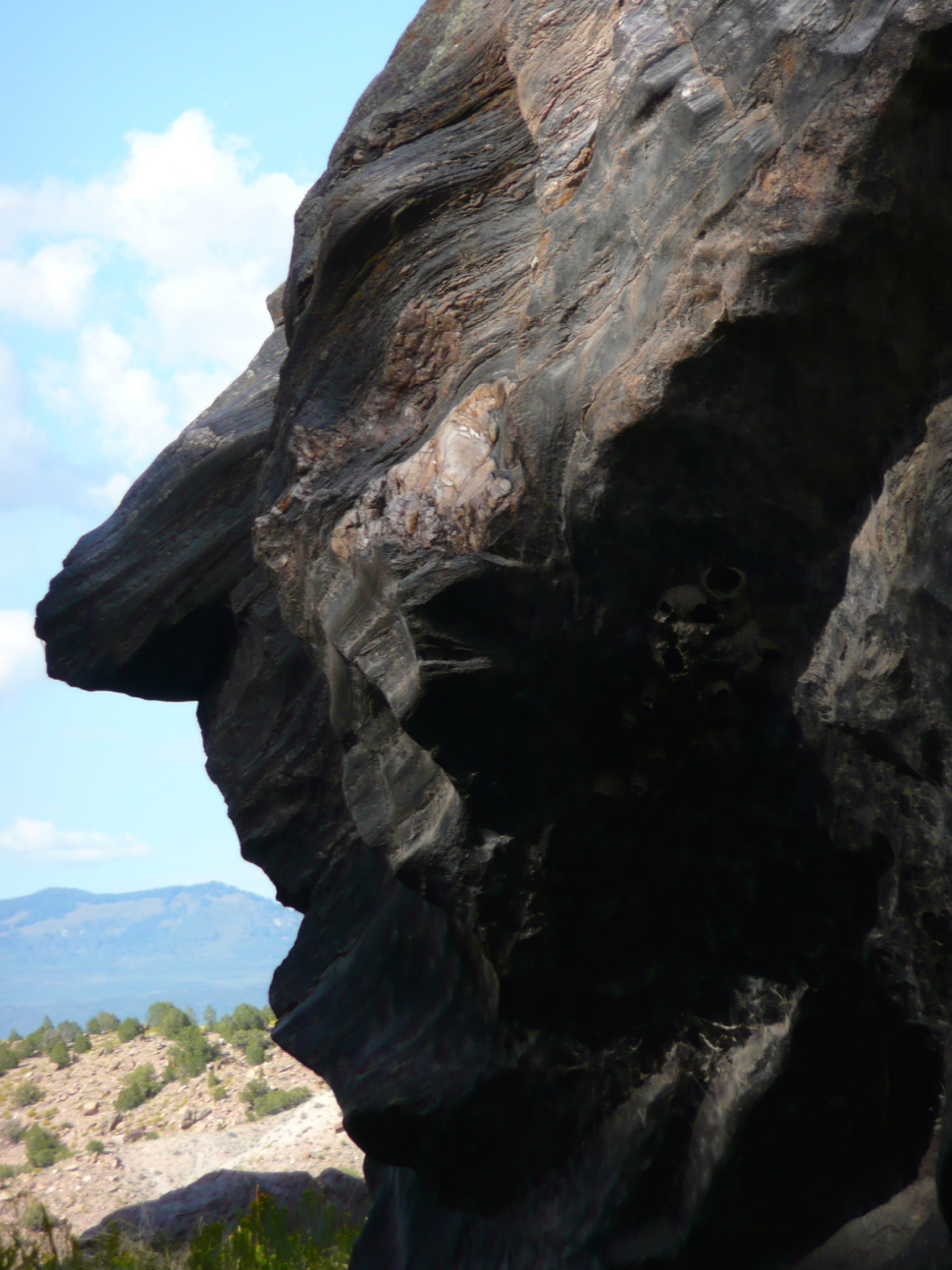
Nixon Rock, in the Gunnison Gorge. Photo: Brent Gardner-Smith/Aspen Journalism
Denver Water’s collection and service areas continue to face severe drought conditions, with historically high temperatures, low streamflows and reservoir storage far below normal. As a result, at its meeting today, the Denver Board of Water Commissioners amended its Stage 1 drought resolution to prohibit lawn watering as of Oct. 1.
Until that time, Denver Water customers are still required to follow mandatory watering restrictions of two assigned days per week through Sept. 30, per the current Stage 1 drought restrictions that remain in place.
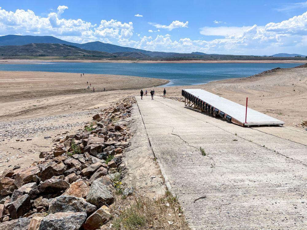
A group of visitors walks down the boat ramp at Williams Fork Reservoir on July 20. The ramp was closed this summer due to low water levels caused by drought. Photo credit: Denver Water.
“The drought afflicting the Denver region and its water supply system has only worsened over the course of the summer, making it clear that we need to take additional steps in response,” said Tyrone Gant, president of the Denver Board of Water Commissioners. “Formally ending lawn watering Oct. 1 will help stretch our supplies, as we will be entering next spring with storage levels far below normal.”
While the board’s Stage 1 drought declaration set a target for system-wide reduction of 20% below the five-year average in water consumption, prolonged hot and dry conditions have led to many customers using more water during their permitted irrigation days to keep trees, shrubs and landscapes alive, making the conservation target difficult to achieve. With drought conditions ongoing, Denver Water staff project storage supplies could drop to 60% before the 2027 runoff season.
“Despite the blistering conditions, customers overall have reduced their water use this summer. But with a lack of precipitation and the hottest first seven months in the Denver region we’ve recorded, we must take this additional step,” said Denver Water CEO/Manager Alan Salazar. “It’s critical that our customers turn sprinklers off Oct. 1, so that we can extend our water supply.”
Lawn watering and all spray irrigation must stop after Sept. 30, 2026, as part of an amendment to the Stage 1 drought declaration originally approved March 25. Trees, plants and gardens may be watered any day by hand if needed. Photo credit: Denver Water.
The resolution includes additional details outlining the kind of watering still permitted after the shutdown date.
High-traffic, active-use grass areas, such as parks and school fields, may only be watered after Sept. 30, under a Denver Water-approved water budget or variance. Additionally, recycled water users can continue to irrigate any day of the week, following the standard watering rules, as they are relying on reused water supply.
Trees, shrubs and perennials may be watered any day with a hand-held hose with a shutoff nozzle or low-volume, non-spray irrigation (such as a drip system). They may not be watered by spray irrigation.
Annuals and vegetables may be watered any day with a hand-held hose with a shutoff nozzle or low-volume, non-spray irrigation, until the first frost. They may not be watered by spray irrigation.
Grass establishment is not allowed after Sept. 30, except under special circumstances outlined under an approved variance.
An irrigation system may be operated for installation, repair or reasonable maintenance, so long as the system is attended throughout the period of operation and water waste does not occur.
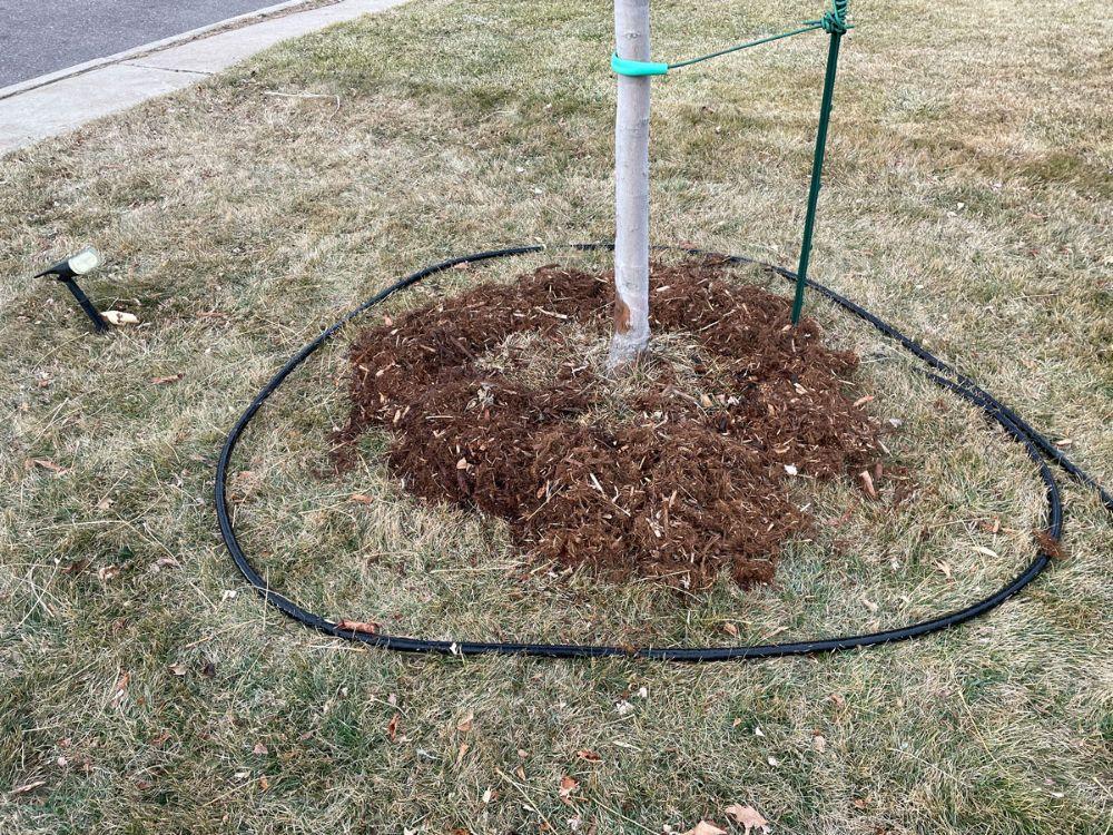
Placing a soaker hose around the tree along the drip line is an effective way to water trees without wasting water. Reminder: Don’t water established trees too close to the trunk. Photo credit: Denver Water.
Conditions in Denver Water’s service and collection areas continue to worsen. The amended resolution outlines specific factors driving the additional board action.
Denver Water’s water collection system watersheds remain in various levels of drought as defined by the U.S. Drought Monitor.
Natural streamflow in the areas that flow into Denver Water’s storage reservoirs for the period of April to July was 95,000 acre-feet, which is 22% of normal and marks the lowest level observed since recordkeeping began 110 years ago.
The Denver metro area is experiencing the hottest year on record (through July) with average daily high temperatures five degrees above normal and four inches below normal precipitation.
As of Aug. 24, 2026, storage in Denver Water’s supply reservoirs is at 72% full, which is significantly lower than the historic median of 94% full for this time of year.
“If you are the only one on your block with a lush green lawn, you might want to revisit your watering practices, as your overuse is compounding the impacts of this historic drought on our water storage supplies,” said Greg Fisher, Denver Water’s manager of demand planning.
“We’re asking everyone to care more and water less, so we don’t have to take more drastic steps in the future, which could create more damaging impacts to our landscapes.”
With reservoir levels continuing to drop, Denver Water is asking customers to Use Only What You Need. Every drop saved, both indoors and outdoors, makes a difference. Photo credit: Denver Water.
Watering season typically runs from May 1 to Oct.1, during which Denver Water’s annual watering rules are in place. In a non-drought year, the start and end dates are general guidance for customers to turn on and off their irrigation systems. With this amendment to its March 25 drought resolution, the board has made the Oct. 1 date mandatory this year, prohibiting lawn watering as of that date.
In addition, the lawn watering ban remains in effect until the board determines how and when lawn watering can resume. That means sprinklers need to remain off in spring of 2027, pending an official resolution from the Board of Water Commissioners. [ed. emphasis mine]
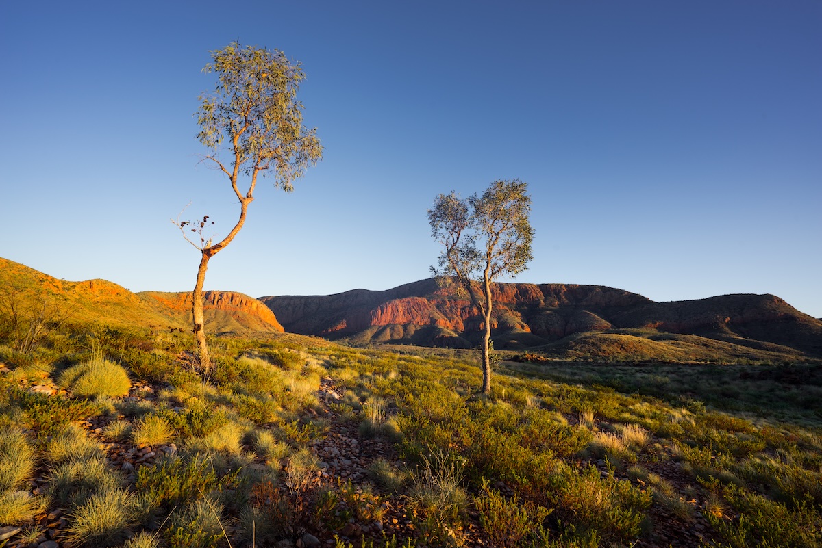
Ormiston Pound, Northern Territory, Australia. Photo provided by Storyblocks.
by Robert Marcos
In a nutshell, the American West’s water crisis is not just a climate or a supply problem, it’s also a governance and an allocation problem. Nature has provided us with a finite supply of water, but our laws and our historical systems are directing that water to be used in inefficient ways. 1 There’s no more glaring example than Imperial Valley farmers who pay a base rate of$20 per acre foot for raw Colorado River water that they use to flood irrigate thousands of acres of forage, to feed cattle.2 Meanwhile just 100 miles away, water districts in San Diego pay $1,579per acre foot for the same untreated water. 3
The Core Concept: Unbundling Water from Land
In the American West, water rights are legally tied to the land. If you sell the land, you sell the water; if you don’t use the water on that land, you lose it. Australia solved this in the 1980s and 1990s through “unbundling”. They legally separated water rights from land ownership.4 Because water is unbundled, it can be bought, sold, or leased on an open, transparent exchange—completely independent of the land. 5
• Water Entitlements: Treat water like shares in a company. A farmer owns a permanent right to a specific percentage of whatever water is available in the river system that year.
• Water Allocations: The actual volume of water credited to that share each season, fluctuating based on rain and dam levels. 6
How This Fixes the West’s Inefficiencies
If the Imperial Valley operated under the Australian system, the economic landscape would shift immediately:
• Eliminates “Use It or Lose It”: An alfalfa farmer wouldn’t have to flood their fields just to protect their legal rights. If a drought hits, they can choose to leave their fields fallow and sell their seasonal water allocation on the exchange to a desperate city or a high-value orchard. 7
• Puts a Clear Price on Water: Right now, Western water is artificially cheap for senior holders. A market creates a real-time price signal. When water is expensive, growing a low-value, thirsty crop like alfalfa in the desert can be financially foolish compared to selling the water itself. 8
J.H. Cullum Clark – a fellow at the George W. Bush Institute, said, “The simple case for allocating essential commodities like water through market mechanisms is that freelyfluctuating prices bring supply and demand into equilibrium. If the amount of a commodity demanded by users exceeds the available supply, higher prices signal to suppliers that they should bring more supply online and to users that they should conserve”. 9
The Colorado River flows through Palisade CO, Friday, June 9, 2023. (William Woody)
Click the link to read the article on the Colorado Newsline website (by Chase Woodruff):
August 26, 2026
Elected officials from across Colorado’s political spectrum continued a 68-year-old tradition last week when they took to the stage at the annual summer conference of the Colorado Water Congress in Steamboat Springs.
Connecting the news in Colorado to the big picture. First convened by Gov. Steve McNichols in 1958, the Water Congress brings together experts, policymakers, agricultural producers and other interest groups to negotiate and strategize in a state where water has always been a scarce and carefully managed resource.
That’s never been more true than it is today, at a time of extreme drought and escalating political conflict over the future of the Colorado River. The river’s cumulative flow at Cameo, just upstream of Palisade and Grand Junction, is at a record low this year, and Colorado and six other states that depend on its water are likely headed for an extended, high-stakes court battle over how to apportion the cuts forced on them by more than two decades of persistently dry conditions.
Addressing the Water Congress, Colorado leaders said the way forward for water users is through, as Attorney General Phil Weiser, the Democratic nominee for governor, put it, “collaboration and innovation.” They talked about storage and diversion projects, conservation measures and drought-resistant crops. They promised to defend farmers and ranchers from so-called “buy and dry” purchases of their water rights by municipal utilities, and to fight off efforts by the Lower Basin states of Arizona, California and Nevada to force mandatory cuts on upstream users in Colorado.
Notably absent, however, from the event’s three days of speeches on water policy — from politicians on both sides of the aisle — was the predominant reason why the situation on the Colorado River is bad and getting worse: human-caused climate change. Neither Weiser nor Victor Marx, the Republican candidate for governor, made any mention of the threat posed to Western water supplies by rising global temperatures. It was missing, too, from speeches by both GOP U.S. Rep. Lauren Boebert, a longtime fossil-fuel industry booster, and Democratic U.S. Rep. Joe Neguse, a former member of the House Select Committee on the Climate Crisis. [ed. emphasis mine]
Dwayne Romero, the Democratic nominee in Colorado’s drought-ravaged 3rd Congressional District, went so far as to say that “the climate is putting new pressure on” water management issues, but no further.
The lack of acknowledgment of the causes of the Colorado River Basin’s post-2000 megadrought comes as Colorado Republicans largely continue to ignore or deny the science of climate change — and as Democrats have been pressured by some party consultants to deemphasize the issue in the wake of their defeat in the 2024 election.
Clockwise from top left: U.S. Rep. Lauren Boebert, a Windsor Republican; Democratic congressional nominee Dwayne Romero; U.S. Rep. Joe Neguse, a Lafayette Democrat; and GOP governor nominee Victor Marx spoke at the summer conference of the Colorado Water Congress in Steamboat Springs from Aug. 18 to 19, 2026. (Photos by Chase Woodruff/Colorado Newsline)
But even as this “climate hushing,” as Rhode Island Sen. Sheldon Whitehouse dubbed it earlier this year, appears to have taken hold in the Democratic Party, hydrologists and climatologists have grown increasingly confident in identifying human emissions, rather than natural variability, as the overwhelming factor driving the West’s water woes.
Whether or not it’s politically expedient for either party to say so, the scientific consensus is that rising levels of greenhouse gases in the Earth’s atmosphere — mostly the result of burning oil, gas and coal — have pushed the Colorado River system to the brink, and that drought conditions are likely to continue to worsen as long as those emissions continue to push global temperatures higher.
‘Hot drought’ and beyond
As of 2024, average global temperatures had risen by more than 2.3 degrees Fahrenheit over pre-industrial levels, according to NOAA data, and climate scientists have concluded that virtually all of that observed warming is due to greenhouse gas emissions from human activity. Parts of Colorado, including much of the Western Slope, are among the areas in the U.S. where average temperature increases have been most severe.
Even in the absence of any other changes to global climate patterns, this higher heat alone can lead to drier conditions on the ground, by increasing the rate at which moisture evaporates — sometimes called evaporative demand, a measure of the atmosphere’s “thirst.” In a 2024 report for the Colorado Water Conservation Board, state climatologists found that evaporative demand had risen by 5% statewide between 1980 and 2022, and was projected to increase by 8% to 17% by 2050.
Within about a decade of the onset of the Colorado River megadrought in the 2000s, researchers began to conclude that rising temperatures were a major factor, making the drought more severe than it otherwise would’ve been. In an influential paper published in 2017, hydrologists Brad Udall and Jonathan Overpeck used the term “hot drought” to describe the basin’s current conditions, distinguishing it it from previous 20th-century “dry droughts,” caused largely by lower precipitation.
Further research has only solidified those conclusions. Using historical soil-moisture data and tree-ring records, one 2022 study found that the current megadrought is the worst dry spell the Southwest has experienced in at least 1,200 years. Studies generally agree that about 40% to 50% of the Colorado River’s declining flows can be attributed to higher temperatures alone.
Colorado statewide annual temperature anomaly (°F) with respect to the 1901-2000 average. Graphic credit: Colorado Climate Center
Still, scientists were cautious about the other half of the hydrological equation — whether, and to what extent, climate change was influencing rainfall and snowfall, too. Modeling global warming’s precise impacts on precipitation patterns proved more complicated than identifying what state climatologists called the “basic physical relationship” between heat and evaporation.
“Compared to the 20th century, the 21st century has indeed been drier, but only by about 2.5%,” hydrologists with the Colorado River Research Group wrote in 2016. “Whether or not this is the leading edge of a trend, or merely a part of normal variability, is unknown.”
In just the last two years, however, new research has begun to dispel that uncertainty — and the findings, wrote Udall and Overpeck last year, “translate to mostly bad news.”
It’s precipitation, too
Overall precipitation in the Upper Colorado River Basin has continued to decline since 2000, with multi-year averages about 7% lower than previous levels as of 2025. Colorado was one of nine states in the West to have experienced their warmest winter on record in 2025-26, and statewide snowpack fell to its lowest level in more than 40 years, setting the stage for this summer’s extreme conditions.
Researchers at the University of Colorado Boulder found last year that global warming is reducing precipitation in the West by stalling a key oceanic climate cycle known as the Pacific decadal oscillation, indicating that the region’s persistently dry conditions are being driven by human emissions “more intensely — and more directly — than previously understood.” Another 2025 paper by a different group of researchers echoed their findings.
“What’s important here is that we’re showing that rainfall has also been influenced by humans, in addition to just evaporation,” Pedro DiNezio, one of the CU Boulder study’s co-authors, told Newsline last year. “Both contribute to drought.”
A final key takeaway from climatological research on the Colorado River is that the higher global temperatures get, the worse things will be for river flows, which are not likely to ever return to their previous “normal.” Udall and others have encouraged the use of the term “aridification,” rather than drought or megadrought, to more accurately describe what’s happening to the river basin. But it’s also why he and Overpeck wrote last year that there’s a “silver lining” to the better understanding of river’s hydrology that researchers have gained over the last decade.
“We can say with confidence that human-caused emissions of greenhouse gases are having an increasingly negative impact on the flows of the Colorado River,” they wrote. “This climate change impact will continue to worsen, but because humans cause it, humans can halt it.”
The Trendline offers analysis on public policy in Colorado. Articles explore ways to think about the news based on research, history and other important context, helping Coloradans connect the headlines to the big picture.
Colorado Newsline is part of States Newsroom, a nonprofit news network supported by grants and a coalition of donors as a 501c(3) public charity. Colorado Newsline maintains editorial independence. Contact Editor Quentin Young for questions: info@coloradonewsline.com.
We can divide the Imperial Valley’s relationship with the Colorado River into four stages. Stage four is accelerating, and it may be our toughest challenge yet.
Water from the Colorado River first arrived via a canal through Baja California June 1, 1901. That started a forty year period of agricultural expansion, floods, shortages, and an accumulation of huge amounts of debt. It was a time of constant uncertainty.
The All-American Canal conveys water from the Colorado River to the Imperial Valley in Southern California. The Imperial Irrigation District is the largest user of Colorado River water. CREDIT: HEATHER SACKETT/ASPEN JOURNALISM
In 1935 Hoover Dam eliminated the danger of floods. The All-American Canal in 1940 finally gave the IID independence from Mexico. The stage of uncertainty was over. The age of prosperity had begun.
From 1940 to 1980, the IID and the valley expanded and refined the system that the pioneers had so sublimely designed. By gravity alone, a network of canals irrigated half a million acres of farmland. The Colorado River supplied all the water we could use.
There was so much water that the IID and Imperial Valley farmers allowed tailwater and drain water to raise the Salton Sea. Tropical storms in 1976 and 1977 added even more water to the Salton Sea. Land near the Salton Sea was flooded. In 1980, farmer John Elmore of Brawley understandably sued the IID for ruining his land there.
Elmore won. IID lost. The courts ruled that the IID was using Colorado River water wastefully and was in violation of the Law of the River.
One might have expected that in 1980 the IID would—like in its early years—ask the farmers and townsfolk to support the massive investment needed to modernize its water control system by taxing themselves.
Instead, the IID accepted the Metropolitan Water District’s offer to pay for efficiency improvements in the IID system. In return, MWD would get 104,000 acre-feet of water every year for a small annual fee. Stage two was over.
Thus began stage three in the history of IID: the age of water transfers and a creeping reduction in water supplies. Midway in this forty year period—in 2003—the IID signed the Quantification Settlement Agreement, which capped the state of California’s allocation at 4.4 million acre-feet and consolidated the MWD transfer agreement with others, including an annual transfer of 200,000 acre-feet to the San Diego County Water Authority.
At the same time, a long drought meant that Lower Basin states of California, Nevada, and Arizona kept drawing down Lake Mead, despite six separate agreements to build elevation. Today, both Lake Mead and Lake Powell are at their lowest elevations of all time.
A new stage is upon us. We can say that it began around 2020, forty years after the Elmore suit in 1980. For now, it’s a return to uncertainty—the prospect of legal challenges to IID’s senior water rights
Stage four incubated for six years as the seven states along the river regularly scrummed to find an arrangement to share plunging water supplies. The problem being so vast and complicated, they left it to the Bureau of Reclamation to find the answer. Just a few days ago, the Bureau released its plan—over a thousand pages—that essentially laid the burden of cutbacks on the Lower Basin states of California, Arizona, and Nevada.
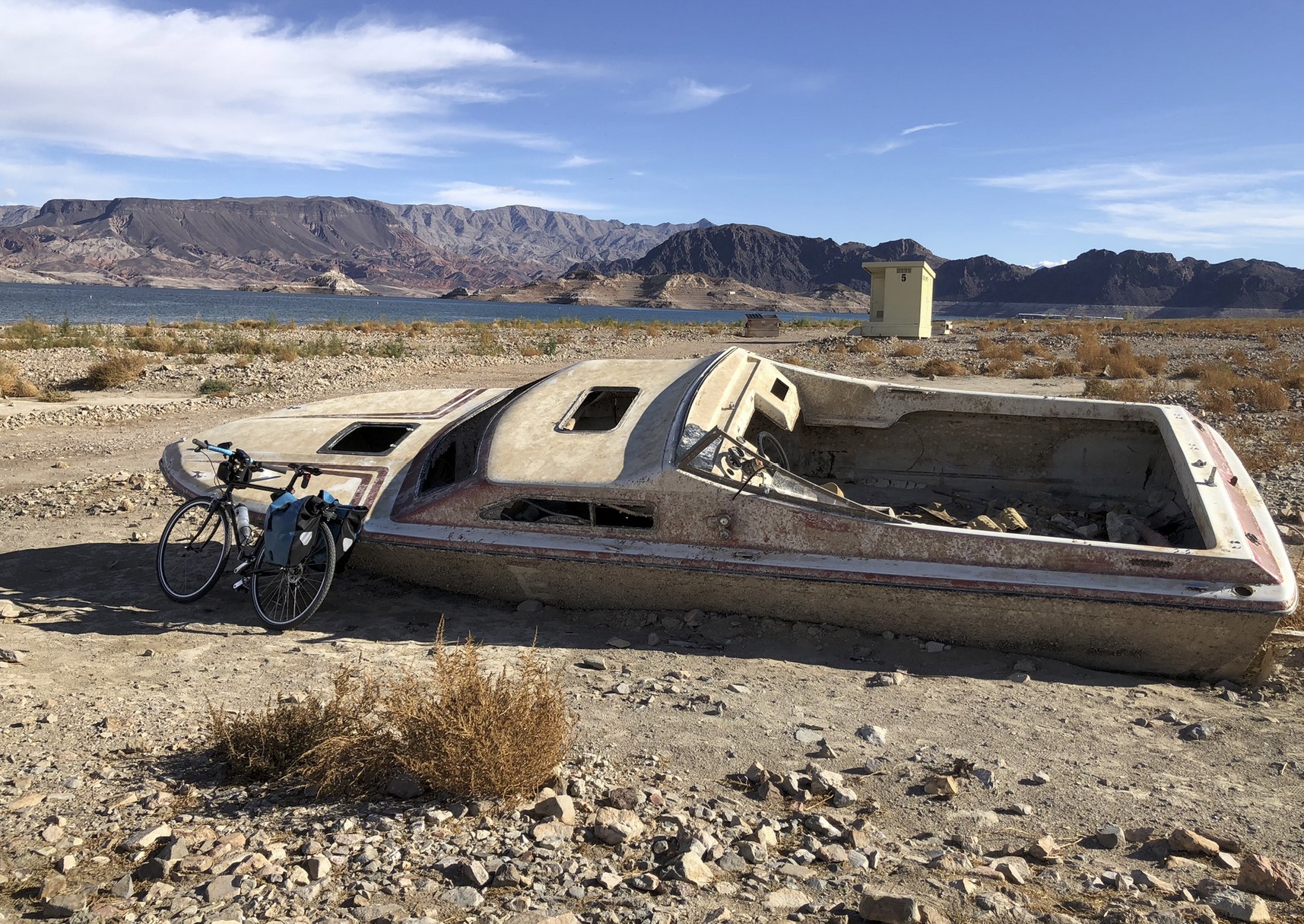
Lake Mead shipwreck. Photo credit: John Fleck
As the two giant reservoirs of Lake Powell and Lake Mead have receded, relics of the past reappear: boats, airplanes, the ruins of flooded towns. A forgotten concept has reappeared too: Water evaporates in transit down the river.
It has become clear to all in the Lower Basin that evaporation and uptake by plants along the river can no longer be ignored.
Through some poor thinking decades ago, the Bureau of Reclamation promised to deliver the same amount of water at Imperial Dam for the IID and at Yuma for Mexico that was released at Lee’s Ferry 600 miles upstream. But because about 13% is lost to evaporation, the Bureau had to rob Lake Mead every year to fulfill its promises. It can’t continue.
That’s why the cuts the Lower Basin states and Mexico have taken since 2020 haven’t been enough. And without a miracle winter, the new cuts they have offered—1.50 million acre feet, somewhat more than the evaporation losses—won’t be enough. This is the simple fact.
It gets worse. Instead of releasing its Colorado River Compact obligation of 8.23 maf, the Upper Basin states will release only 6 or 7 maf next year. Therefore, the more likely cuts will be in the neighborhood of 2.5-3 million acre-feet.
Thus, we’re off and running to the courts, which all the states repeatedly stated they wanted to avoid. For the IID, it’s stage four of its history with the Colorado River. The only certainty at this point is that the IID will be embroiled in tough legal challenges to protect its senior water rights as heavy cuts hit users of Colorado River water. Let’s hope it doesn’t last forty years.
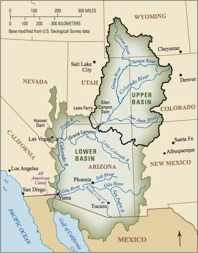
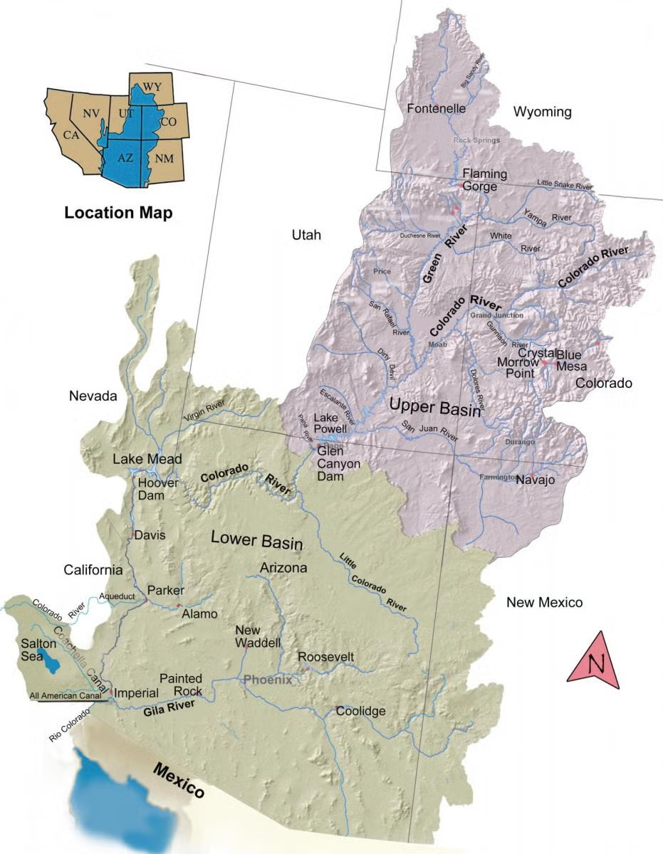
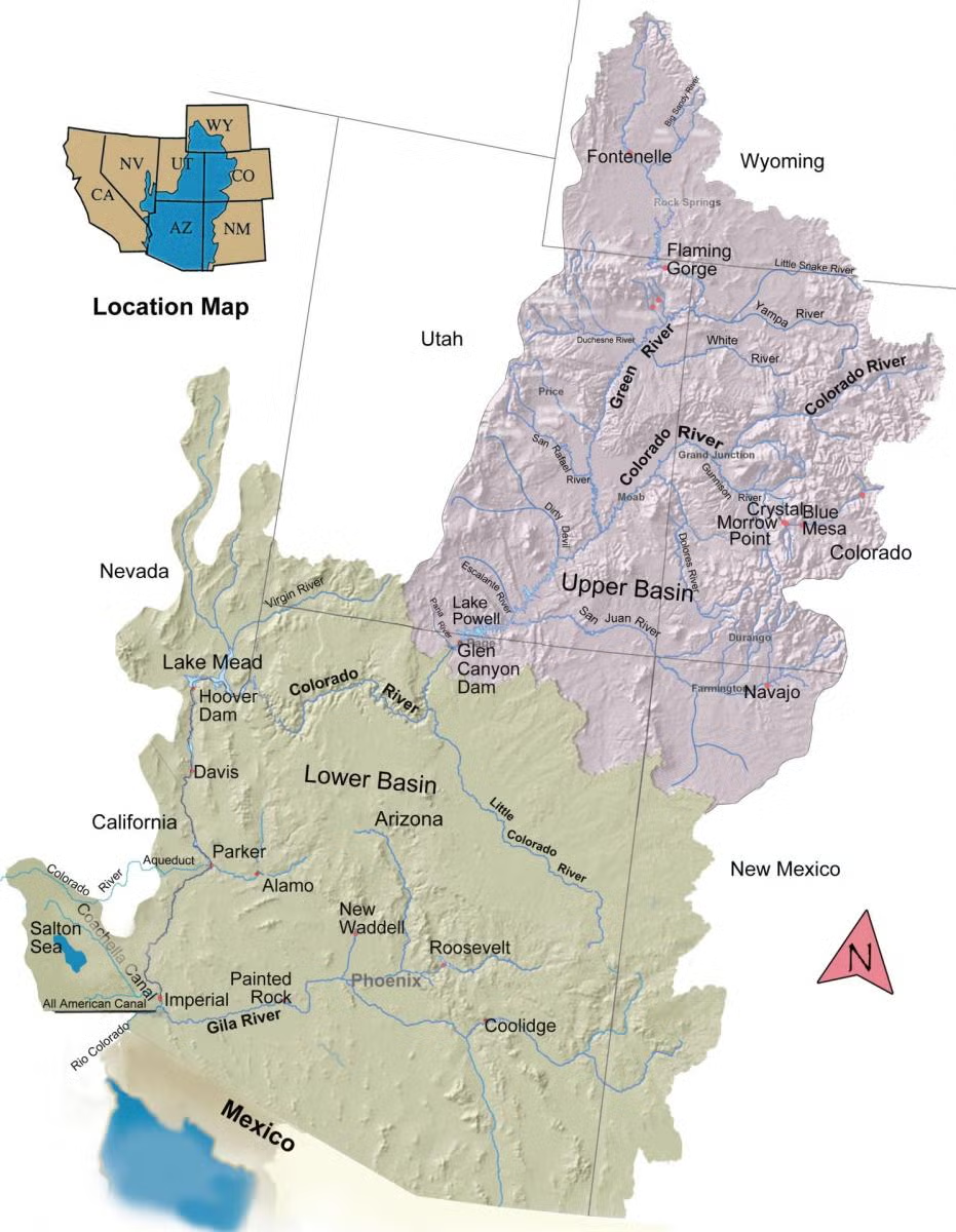
The Colorado River Basin spans seven U.S. states and part of Mexico. Lake Powell, upstream from the Grand Canyon, and Lake Mead, near Las Vegas, are the two principal reservoirs in the Colorado River water-supply system. (Bureau of Reclamation)
Created by Imgur user Fejetlenfej , a geographer and GIS analyst with a ‘lifelong passion for beautiful maps.’ It highlights the massive expanse of river basins across the country – in particular, those which feed the Mississippi River, in pink.
Why don’t we just build a pipeline from the Mississippi River, Great Lakes, or another major water source and pump that water to Lake Mead? Simple, right?
It’s one of the most common suggestions we hear to solve drought in the West. In this episode of Tap the Truth, we explore what it would actually take to move water across the country and why these projects are more complicated than they might seem.
Importing water is not as simple as laying pipe across a map. Interstate agreements, water rights, environmental impacts, water quality concerns, permitting challenges, and costs all need to be considered.
We also discuss why communities throughout the country are facing their own water challenges and why conservation remains one of the most reliable and cost effective tools available today.
Want to make a personal impact on Southern Nevada’s water future? Visit SNWA.com to learn about water saving programs, rebates, and conservation tips.
Watch more Tap the Truth episodes for straightforward answers to common questions about water, Lake Mead, the Colorado River, and Southern Nevada’s water supply.
The Yampa River at Deerlodge Park July 24, 2021 downstream from the confluence with the Little Snake River. There was a ditch running in Maybell above this location. Irrigated hay looked good. Dryland hay not so much.
A rare call has been placed on the main stem of the Yampa River as historic drought conditions continue to strain water supplies across Northwest Colorado, potentially curtailing more than 300 upstream diversions and prompting water managers to urge residents to conserve wherever possible. The call was placed Aug. 19 at the Lily Park Ditch No. 1, Pump Station No. 1, near the confluence of the Little Snake and Yampa rivers. The agricultural water right carries a priority date of May 28, 1923…Holly Kirkpatrick, public affairs manager for the Upper Yampa Water Conservancy District, said the call is only the fifth to occur on the main stem of the Yampa River below Stagecoach Reservoir…Kirkpatrick said well over 300 diversions upstream of the calling point could be subject to curtailment if they have priority dates junior to May 28, 1923. The call also applies to tributaries upstream of the Little Snake and Yampa river confluence. Some of those tributaries, however, may already have little or no natural streamflow available because of the severity of this year’s drought, she said. The Upper Yampa Water Conservancy District reported Aug. 20 that baseflows in tributaries across the basin remained below the 10th percentile, an indication of unusually low water levels. The district’s report showed the Yampa River below Craig flowing at 94 cubic feet per second, compared with a historical mean of 156 cfs for the date. In Steamboat Springs, the river was flowing at 58 cfs compared with a historical mean of 96 cfs. Reservoir releases are now supplying much of the water moving through the Yampa River, Kirkpatrick said.
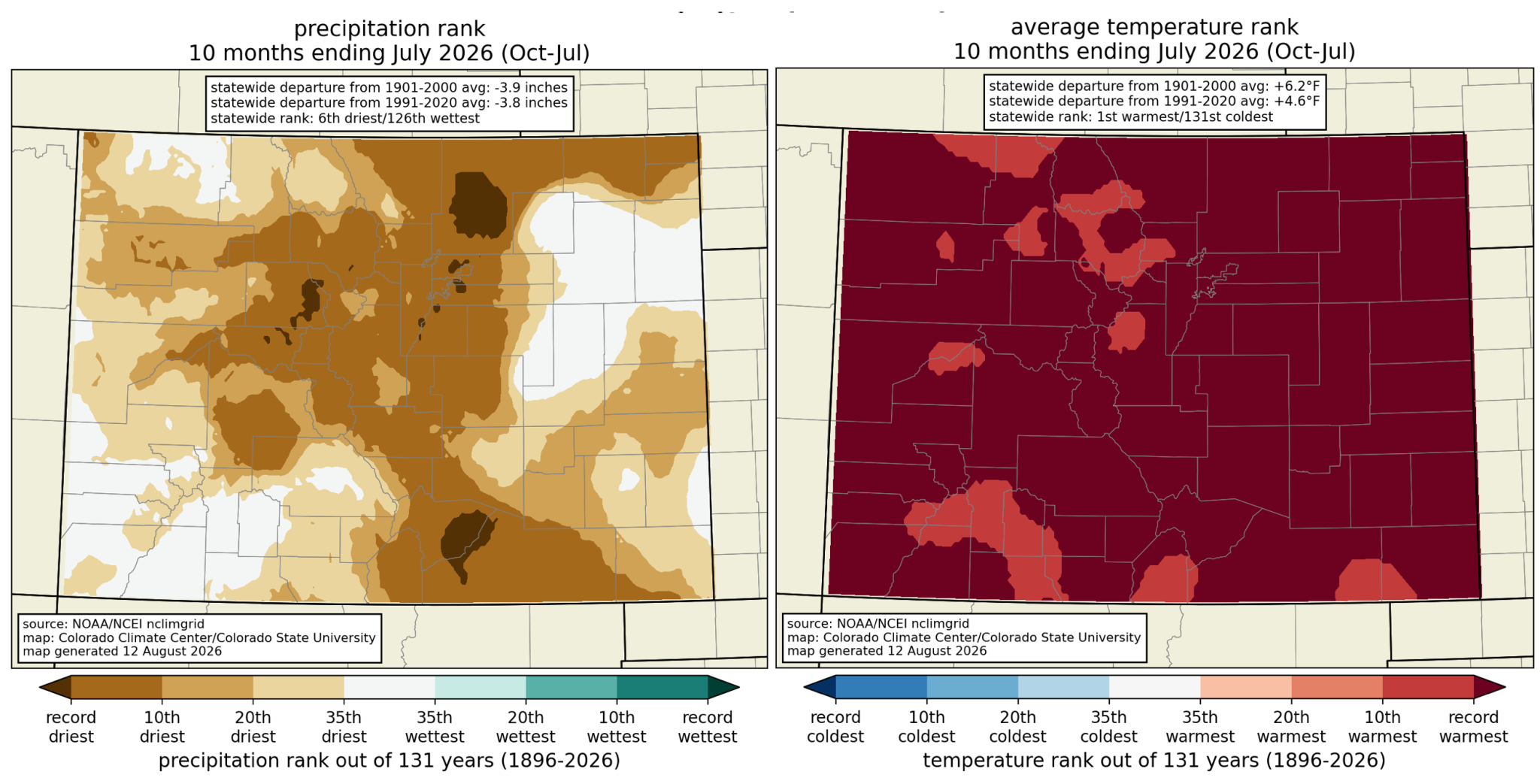
As Colorado nears the final month of the 2026 water year, extreme drought is persisting across the state as many regions, including the Western Slope, continue to rack up records when it comes to heat as well as precipitation — and the lack thereof.
“We continue to be way above anything that we’ve seen in the data record for Colorado; we’re about 2 degrees warmer than the previous hottest water year to date on record — that was 1934 — and over 4 degrees warmer than the 1991 through 2020 average,” said Allie Mazurek, engagement climatologist at the Colorado Climate Center, at the Aug. 25 Water Conditions Monitoring meeting of the Colorado Water Conservation Board.
“The dryness has not been quite as remarkable as the warmth, but again, we have ranked as the sixth driest on record through the end of July, and are still among some of the driest water years that we’ve seen,” she added…
The first 10 months of the water year — which kicked off Oct. 1, 2025 — have seen three months rank as the hottest on record and six months fall among the top 10 hottest. While not over, August has already seen above-average temperatures, with many areas averaging 4-6 degrees hotter than normal, including west of the Continental Divide, which Mazurek said has experienced “the most notable warmth compared to average.”…While July and August are not the first months this water year to set these kinds of records — March, for example, saw statewide temperatures nearly 10 degrees above the 30-year average — Mazurek said it does ring a different kind of alarm bell…All in all, Mazurek described the water year so far as “very, very warm,” sitting 4.5 degrees above the average temperatures from 1981 to 2020.
For Colorado, the first 10 months of the 2026 water year have brought record-setting heat and precipitation (or lack thereof). Credit: NRCS
Central Arizona Project map via Mountain Town News
Click the link to read the article on the KTAR website (Heidi Hommel). Here’s an excerpt:
August 26, 2026
The Upper Basin is on the verge of violating the Colorado River Compact for the first time in the agreement’s 104-year history, failing to send enough water downstream to the Lower Basin, Central Arizona Project President Terry Goddard told KTAR News 92.3 FM on Monday…Goddard said the new framework from the U.S. Bureau of Reclamation that will guide operations through 2036 could make it worse…
“We have a violation of the compact either today or within the next month,” Goddard said.
The compact requires the Upper Basin to deliver 75 million acre-feet to the Lower Basin over any rolling 10-year period, averaging 7.5 million acre-feet a year. Goddard said the Upper Basin is falling short of that obligation for the first time in the compact’s history, releasing only 6 million acre-feet this year and running right at the 10-year threshold. [ed. As Ed Millard says, the action is not from the Upper Basin but from Reclamation]
Map of the Colorado River drainage basin, created using USGS data. By Shannon1 Creative Commons Attribution-Share Alike 4.0
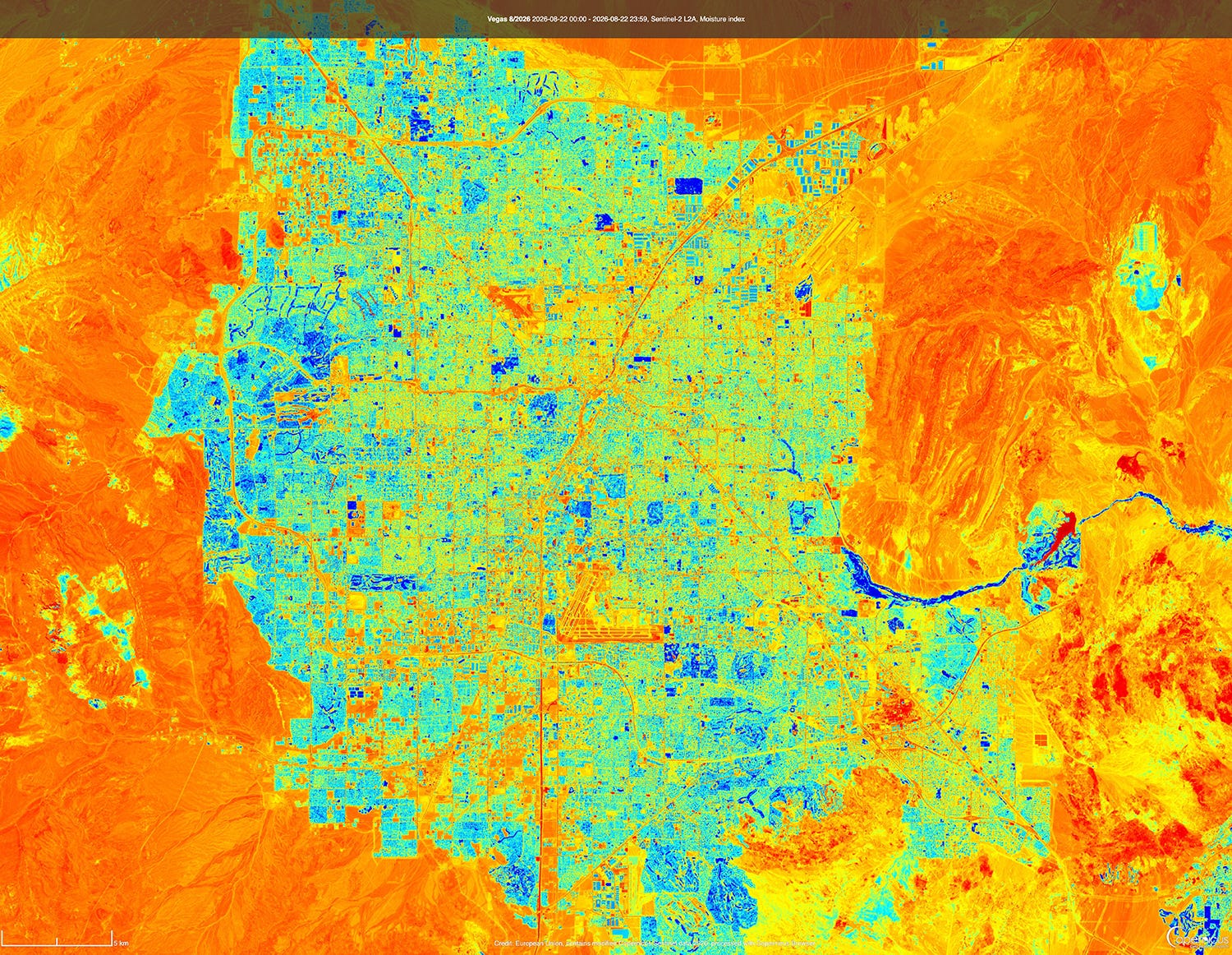
A moisture index satellite image of Las Vegas, Nevada. Southern Nevada stands to lose as much as 71% of its Colorado River allotment under the Department of Interior’s operating guidelines for the river and its two largest reservoirs. Source: Copernicus Browser.
THE NEWS:The U.S. Interior Department on Friday handed down the operating guidelines for the Colorado River for the next two years, while also finalizing the 10-year decision framework that will guide these plans. And on Monday, Nevada filed a lawsuit challenging both the framework and operating plan, saying that potential shortages required by the plan could cause “cause devastating environmental, socioeconomic, and health and human safety impacts to southern Nevada and its citizens.”
THE CONTEXT: Interior, i.e. the Bureau of Reclamation, did two things. The first was to hand down a record of decision on the framework that will guide operating plans for the next decade, which I wrote about here, so I’ll skip the details this time.
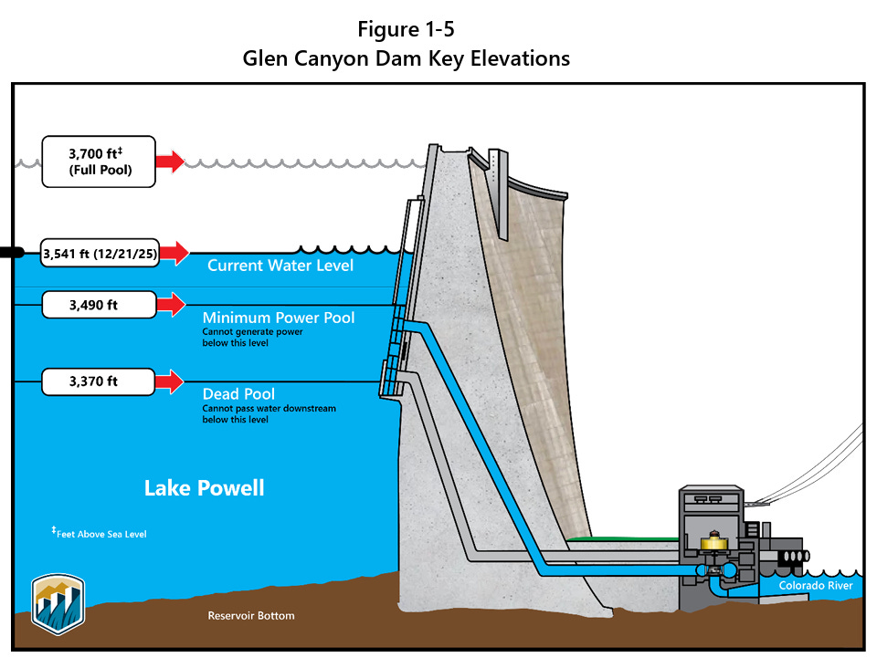
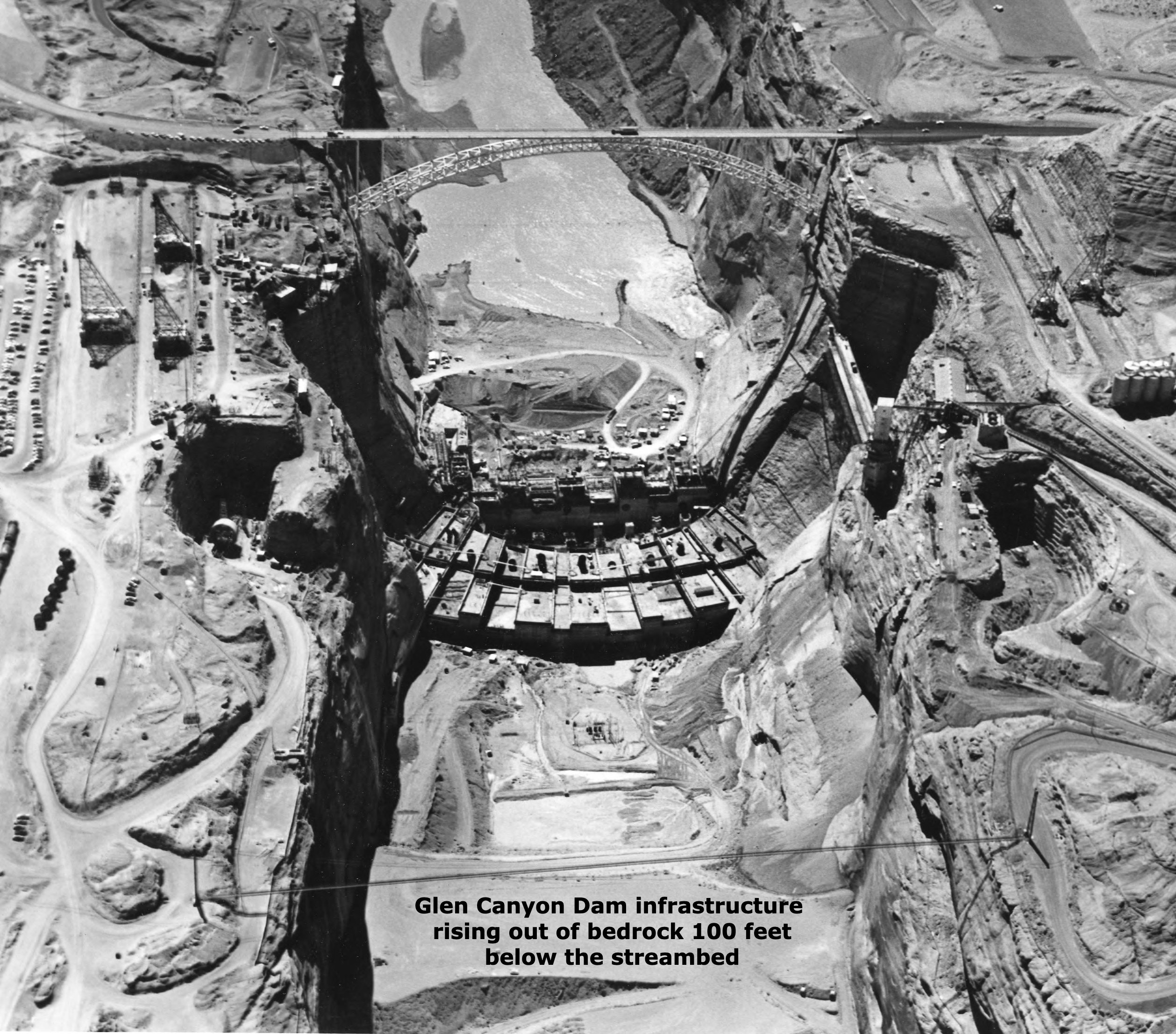
They also released a more specific plan for the 2027 and 2028 operating years. In the new plan, the feds affirm their commitment to “defending” minimum power pool in Lake Powell, or a reservoir surface elevation of 3,490 feet. When the water falls below this level, water can no longer be released via the penstocks and hydropower turbines, so it must all go through the lower river outlet works, which weren’t designed for sustained use.
Notably, Reclamation plans to do this by “initially seeking to maintain a minimum elevation of 3,510 feet. This provides an operational buffer and provides additional flexibility in recognition of the operational risks associated with sustained operations below elevation 3,490 feet … .”
The current elevation is 3,518 feet, meaning it could reach that upper buffer zone of 3,510 feet in October if current levels of decline continue.
To prevent it from falling any further, Reclamation would cut back releases from Glen Canyon Dam, which in turn would cut flows through the Grand Canyon and into Lake Mead, which would pull down Mead’s levels and trigger mandatory cuts for the Lower Basin users. Under the new operating plan so far, these cuts aren’t as onerous as many feared, and actually match up with what the Lower Basin had proposed to do voluntarily. The deets:
The Lower Basin would receive 6.25 million acre-feet from the Colorado River, or 1.25 MAF below the Colorado River Compact’s allotment of 7.5 MAF.
Arizona would receive 2.04 MAF; California 3.96 MAF; and Nevada 250,000 AF.
This means Arizona would take a 760,000 AF cut; Nevada a 50,000 AF cut; and California a 440,000 AF cut.
Arizona takes the largest cut by percentage and volume because the Central Arizona Project, which delivers most of the state’s Colorado River water, has junior water rights to other big users on the river.
But if reservoir levels continue to drop, then Reclamation could impose further cuts on the Lower Basin, potentially slashing Nevada’s water deliveries by as much as 213,556 acre-feet, or about 71% of its total entitlement of 300,000 acre-feet. This would be truly disastrous for the Las Vegas metro area, which relies on the Colorado River for about 90% of its water. And it’s not like there are a bunch of alfalfa fields the city could “buy and dry” for the water rights.
The Southern Nevada Water Authority has managed to cut overall water consumptionover the last three decades, even as the population has soared, through system-wide efficiencies, incentives, tearing up ornamental grass, water recycling, and extra fees for water gluttons. Las Vegas still has room to conserve, but as Western water scholar John Fleck put it, there “is an absurdity to a plan that would require Las Vegas to cut 71%. That’s existential.”
Even more astonishing than the fact that the federal government is considering virtually drying up one of the Southwest’s major metropolises is their justification for doing so: To protect Glen Canyon Dam and keep it producing hydropower, even at greatly diminished levels, and — though it’s not stated — to keep lake-based recreation somewhat viable.
You have to remember that when the feds vow to defend the 3,500-foot level at Lake Powell, and when they refuse to even consider re-engineering Glen Canyon Dam to allow for releases at lower levels, either by rebuilding the outlet tubes or tunneling a bypass around the dam, they are also saying they are going to trap more than 4 million acre-feet of water behind the dam that could otherwise flow downstream into the Grand Canyon and Lake Mead. That’s enough water to fill Nevada’s entire allotment for more than 13 years that, instead, will be sitting in the reservoir and slowly evaporating.
Nevada’s lawsuit — which is against the federal government, not the Upper Basin states — alleges that the feds’ plan violates the Law of the River. It slams the plan for not explicitly calling for releasing more water from Upper Basin reservoirs to prop up Powell, does not require Upper Basin states to make any cuts, and fails to consider a long-term alternative or engineered solution alternative to address Glen Canyon’s infrastructure limitations. The plan also does not account for its potential impacts on hydropower production at Hoover Dam, which drops off steeply as reservoir levels decline (meaning that preserving power output at Glen Canyon could lead to a net reduction in combined output from the two dams).
Save the Colorado, a river advocacy group, came out in support of Nevada’s lawsuit in a written statement. “Las Vegas has one of the best water conservation programs in the entire U.S.,” said Gary Wockner, the group’s executive director. “Penalizing Las Vegas for water use is like penalizing an obese person who lost a lot of weight taking GLP1s.”
Rough Times at the national parks these days. In Bryce Canyon, a sudden thunderstorm left visitors stranded on trails and requiring rescue, with two of them transported to a hospital for hypothermia. It also unleashed some serious flash flooding. In Zion National Park, a rockslide narrowly missed a shuttle bus and forced the closure of a portion of the Zion Canyon Scenic Drive. And in Canyonlands, officials were searching for a missing individual in Horseshoe Canyon, a remote area north of the park’s Maze district. Temperatures in the area were in the 90s. In Death Valley, a French tourist died after his car got stuck in the mud on a remote road in 116° F heat.
The video below shows flooding near Tropic, Utah, downstream from Bryce Canyon National Park. Source: Garfield County Sheriff.
In May, I wrote about how climate change and aridification and a shrinking Lake Powell were coming for the Bullfrog Marina, on the northwest side of the reservoir. The water was simply getting too low for the marina to remain viable, so they were planning on moving it across the reservoir to Halls Crossing Marina.
At the time, it was not yet clear how lower water levels and the marina’s removal might affect visitation to the remote area. Now preliminary numbers are in:
67,277: Total recreation visitors to the Bullfrog District of Glen Canyon National Recreation Area, January through July 2025
44,206: Total recreation visitors to the Bullfrog District, January through July 2026.
That’s a decrease of over 23,000 visits, or a 34% drop. Even more dramatic is the drop in overnight stays in July, from over 47,000 in 2025 to just 17,000 in 2026. Then did folks make the long drive over to Halls Crossing, instead? It appears that some of them may have once the marina was moved, but overall this year visitation is also down on the northeast side of the reservoir.
18,023: Total recreation visitors to the Halls Crossing District of Glen Canyon National Recreation Area, January through July 2025.
15,099: Total recreation visitors to the Halls Crossing District, January through July 2026.
That’s a decrease of 2,944 visits, or a 19% drop. This may not all be related directly to the dropping lake levels. Horseshoe Bend, which is in Glen Canyon National Recreation Area but downstream from the reservoir, has also seen a significant drop off in visitors this spring and summer. In a future dispatch I’ll take a closer look at tourism numbers in general to get a better sense of how widespread the declines are.
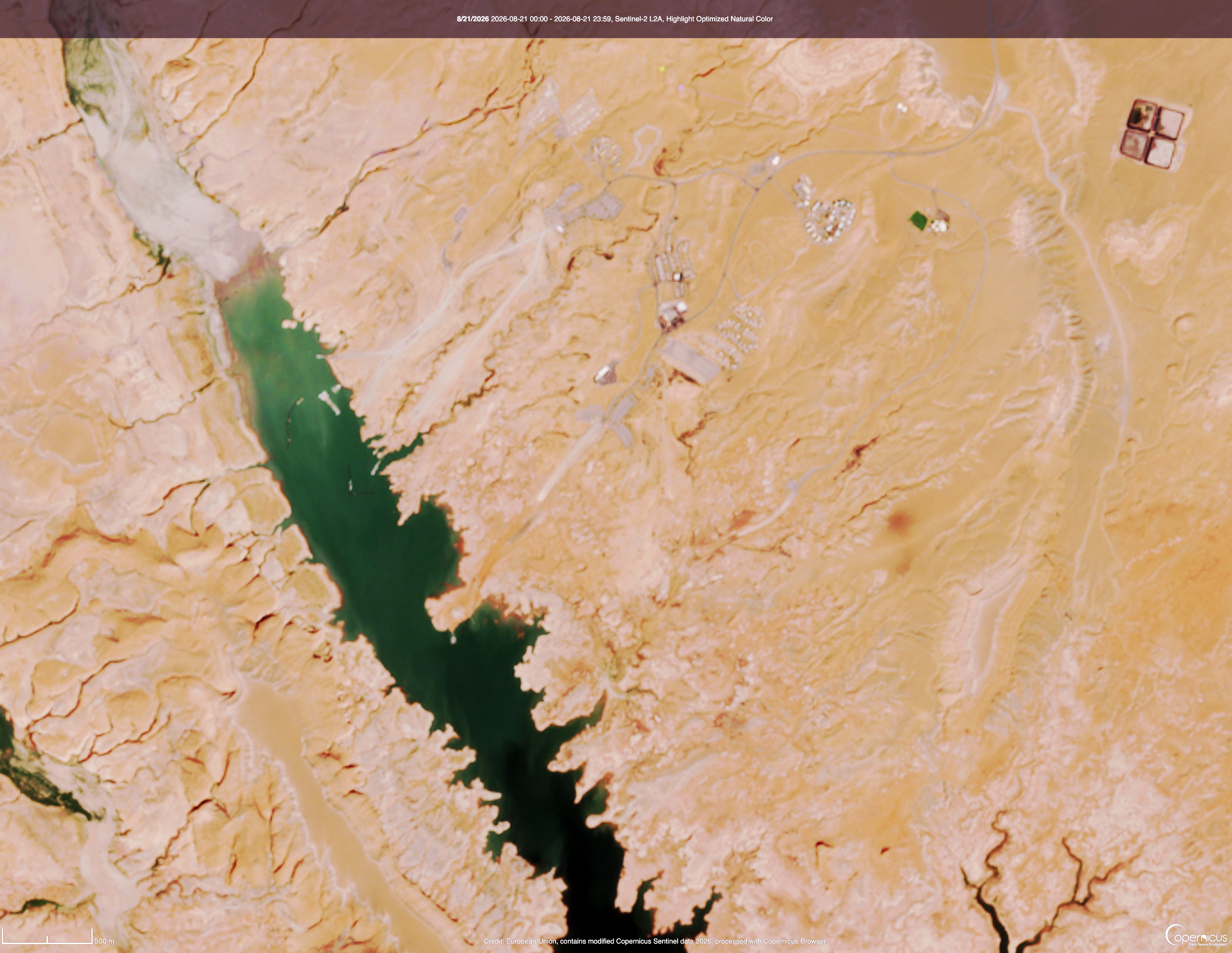
And now for the images showing Bullfrog with the marina, and without. The first image is from August 2024, when the reservoir’s surface elevation was at about 3,580 feet. The marina was still there, and the boat ramps still made it all the way to the water. The second image is from August 2026, with a surface level of just over 3,518 feet. Look closely and you’ll see the marina is gone, and the ramps are high and dry.
Bullfrog Bay and Marina, August 2024. Source: Copernicus.
Bullfrog Bay and no marina, August 2026. Source: Copernicus.
During the early part of last week, an amplified ridge-trough pattern over North America brought widespread late summer heat to the West and south-central US, with milder temperatures overspreading the Corn Belt and gradually shifting to the Northeast and mid-Atlantic states. The north side of the mean ridge provided a focus for convective activity, with narrow swaths of locally heavy rainfall extending across Nebraska and Missouri, while shortwave troughs brought several rounds of storms to the eastern Corn Belt and parts of the mid-Atlantic and southern New England. Underneath the ridge, dry weather combined with excessive heat continued to promote rapid onset drought across much of the South region. Across the Southeast, summer convection competed with enhanced evapotranspirative demand due to hot temperatures, causing some degradation in areas that missed out on thunderstorm activity. Across the West, an active monsoon pattern continued to bring localized relief to parts of Arizona and New Mexico, while excessive heat and drier conditions promoted drought expansion across eastern New Mexico and portions of the Intermountain West, Great Basin, and the Northwest.
Across Alaska, improved rainfall eased drought conditions over the central interior, while drier weather sparked some degradation over the southeast. Across Hawaii, following widespread heavy rainfall from Hurricane Lala in the previous week, Tropical Storm Moke passed well south of the state, bringing enhanced flow and precipitation to the windward sides of the islands. Across the Caribbean, a suppressed convective regime continued to promote gradual drought expansion across Puerto Rico…
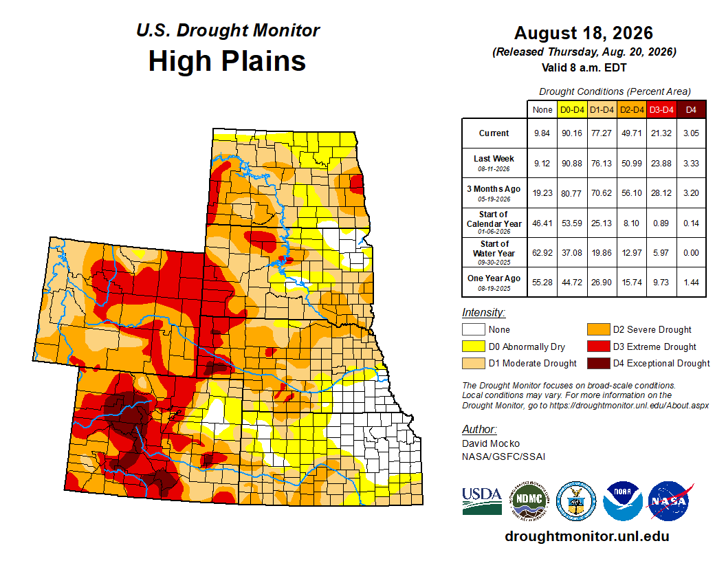
The High Plains saw a mixture of drought degradation and localized improvement. Rapid drought deterioration continued across southern Kansas and southeastern Colorado, where dry conditions and excessive heat aggravated agricultural impacts. Further north, widespread convection brought drought relief east of the Front Range across eastern Colorado, though some deterioration occurred in the Rockies of Colorado and Wyoming where water storage impacts from last spring’s limited snow cover are beginning to mount. Organized convection along the northern periphery of the ridge promoted drought reduction in central Nebraska. Showers mostly maintained a status-quo depiction across South Dakota, save for small areas of degradation along its respective borders with North Dakota and Minnesota. More widespread drought degradation was noted across North Dakota, where precipitation was sparser outside of a single, narrow convective event that tracked across the northeastern corner of the state…
Colorado Drought Monitor change map ending August 25, 2026.
Seasonal dryness continued across the Pacific Coast states and much of the Great Basin, where persistent above-normal temperatures drove high demand on water resources and led to localized degradation. Extreme Drought (D3) expanded slightly across southern Oregon and northern Washington, where soil moisture and groundwater levels remained critically poor. Extreme to Exceptional (D4) drought also expanded into northeastern Idaho, with degradation noted in small portions of Utah and the southern California deserts. Elsewhere, ongoing monsoonal convection promoted drought relief across much of Arizona and western New Mexico, though persistent heat and dry conditions drove drought expansion across eastern New Mexico…
Under a persistent heat dome ridge maintaining mostly dry conditions and unrelenting heat, widespread rapid drought expansion continued for another week across the South region. Weekly maximum temperatures exceeded 100 degrees F across nearly the entire region – with the exception of Tennessee – and peaked above 110 degrees along the Texas-Oklahoma border. Condition Monitoring Observer Reports (CMOR) submitted to the National Drought Mitigation Center highlighted rapidly worsening impacts, including dry stock ponds, wilting trees, dust storms, and elevated wildfire activity. Drought expansion and intensification were most pronounced across Texas, Oklahoma, Louisiana, and Arkansas, while conditions also began to noticeably deteriorate across Mississippi. Small-scale convection provided only highly localized, brief relief to isolated portions of central Oklahoma and Arkansas…
Looking Ahead
Over the next 7 days, upper-level ridging centered over the western U.S. is forecast to progress eastward, shifting hotter conditions to the East while bringing a potential reprieve from extreme temperatures to the West. Excessive heat will persist across the south-central U.S., which may continue to fuel rapid drought expansion and intensification. Enhanced monsoonal convection is favored across Arizona, with moisture extending northward into Utah and parts of the northern Rockies, while light, early-season precipitation may overspread southern California. Forecast precipitation amounts across the South region would be insufficient to offset ongoing moisture deficits. Across the Midwest, light to locally moderate precipitation is expected. Seasonal convection will linger across the Southeast early in the period before drier conditions move in by the end of the period. Along the Eastern Seaboard, initial storminess will give way to drier conditions, though unsettled weather may return to the Northeast by late week.
For the 8-to-14-day period, below-normal temperatures are favored across the Northwest, while elevated odds for above-normal temperatures extend across much of the remainder of the CONUS. The highest probabilities for excessive heat remain anchored over the south-central and southeastern U.S., maintaining heavy evapotranspirative demand in regions experiencing rapid drought degradation. Above-normal temperatures are also favored across Hawaii and the Alaska Panhandle and southeastern Alaska, while below-normal temperatures are more likely across the rest of Mainland Alaska. The precipitation outlook exhibits a weaker signal for the CONUS, with slightly enhanced chances for above-normal precipitation across the western U.S. and New England, while near-normal precipitation is favored elsewhere. High probabilities for above-normal precipitation extend across Hawaii, with enhanced odds for above-normal rainfall exist across most of Alaska except for the Panhandle.
US Drought Monitor change map ending August 25, 2026.
Colorado now has more than 200,000 EVs on the road and over 7,500 public charging ports statewide. That means it's getting easier than ever to explore Colorado in an EV, including many of our iconic scenic byways.
Colorado River “Beginnings”. Photo: Brent Gardner-Smith/Aspen Journalism
Click the link to read the article on the KUNC website (Stephanie Daniel):
August 24, 2026
This story was produced by the Mountain West News Bureau, a collaboration between Boise State Public Radio, Wyoming Public Media, Nevada Public Radio, KUNR in Nevada, KUNC in Northern Colorado, KANW in New Mexico, Colorado Public Radio and KJZZ in Arizona as well as NPR, with support from affiliate newsrooms across the region. Funding for the Mountain West News Bureau is provided in part by the Corporation for Public Broadcasting and Eric and Wendy Schmidt.
Three states are being required to cut their water use under a final plan for managing the Colorado River over the next two years, while the four upstream states are being asked to voluntarily conserve water.
The U.S. Department of the Interior released the Record of Decision for managing the river over the next decade and laying out more specific rules for the next two years. The plan is intended to protect Lake Powell and Lake Mead, which have fallen to historically low levels after years of drought.
Arizona, California and Nevada will have to collectively reduce their water use by 1.25 million acre-feet per year over the next two years, with additional restrictions possible if conditions worsen, according to the plan.
Colorado, Utah, New Mexico and Wyoming are not subject to mandatory reductions; instead, those states are setting up programs to voluntarily conserve water.
“Under the proposed plan issued by the Department of the Interior, southern Nevada could lose more than 70 percent of its already meager Colorado River allocation while the Upper Basin states of Colorado, Utah, New Mexico, and Wyoming are not required to contribute a drop,” Nevada Governor Joe Lombardo said in a news release on Monday.
Upper Basin officials say their water users already face reductions when drought leaves less water available and that the federal government doesn’t have authority to impose mandatory cuts in their states. But they say the Upper Basin is willing to contribute voluntarily.
“Not because we have to, or that we feel like we legally have to,” Colorado’s river negotiator Becky Mitchell said at a conference last week in Steamboat Springs, “but because the importance of this system and the survival of this system is a responsibility for everyone.”
The federal framework envisions up to 200,000 acre-feet of water per year in Upper Basin contributions when conditions allow. The federal government is dedicating $100 million to the Upper Basin to compensate farmers, cities or other water users to use less. Colorado, Wyoming and Utah are also setting up their own state programs to facilitate participation.
Colorado officials expect applications could open this fall and projects could start next year.
“Our position has been and continues to be that we’re going to be part of the solution,” said Amy Ostdiek, section chief for the Colorado Water Conservation Board at the Steamboat conference. “We’re going to do it in the ways that we can, at the times that we can, but we can’t provide water certainty for our neighbors downstream that we don’t have ourselves.”
Criteria for selecting projects, how water users will be compensated and how the Upper Basin gains credit for conserved water are still being worked out.
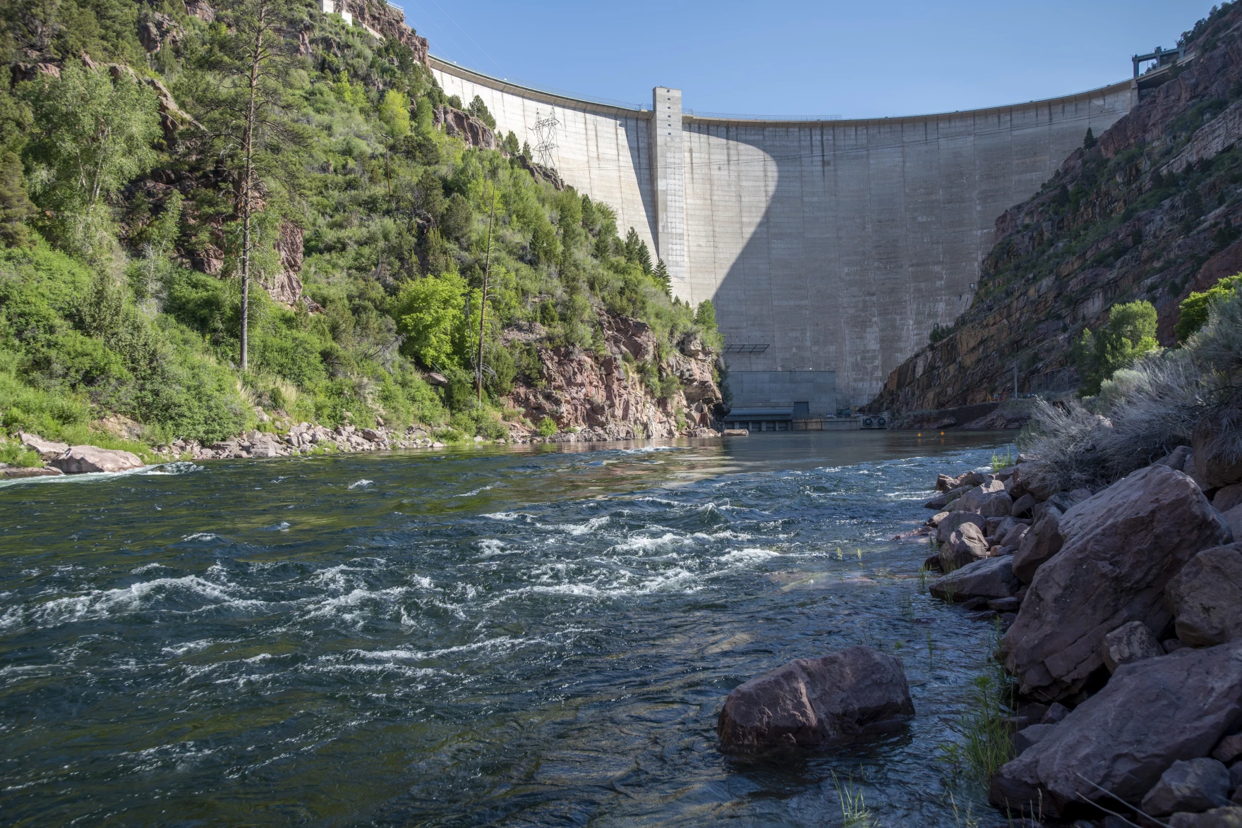
The Green River flows beneath the Flaming Gorge Dam in Utah. The federal government is sending water from the reservoir to prop up Lake Powell, something it could do in future dry years under a plan to manage the Colorado River. Ted Wood/The Water Desk
The federal plan also creates a potential “conservation pool” in Lake Powell, allowing the Upper Basin states to store a certain amount of conserved water.
John Berggren, a water policy analyst with the nonprofit Western Resource Advocates, has advocated for a conservation pool and said its inclusion in the federal framework is promising. However, exactly how it would work is not clear.
“How that pool operates, how the water is used, when it’s moved, if it’s moved, who decides that – all that is going to depend on future agreements,” he said.
Some key questions, he said, have to do with what the conserved water is credited towards, such as whether it’s used to offset shortages in the Lower Basin or help the Upper Basin fulfill their legal obligations to deliver water downstream.
The new framework also allows the Upper Basin to come to an agreement with the Interior Department to draw down a few reservoirs when Lake Powell nears getting too low for hydropower. That started happening this year, with water released from Flaming Gorge Reservoir in Wyoming.
Adult Zebra mussel. Photo credit: Colorado Parks and Wildlife
Click the link to read the article on The Aspen Times website (Ali Longwell). Here’s an excerpt:
August 25, 2026
After 2025 saw a flurry of zebra mussel detections in the Colorado River system, Colorado Parks and Wildlife’s weekly sampling this summer has led to zero new discoveries of the invasive species. This does not mean, however, that zebra mussels — notorious for their prolific reproduction and destruction of ecosystems and infrastructure — are gone from the basin or that the battle to curb their spread is over. When zebra mussels establish a presence in a body of water, they multiply quickly. A single zebra mussel can produce up to 30,000 veligers — their microscopic, free-floating larvae — in one spawning event and up to one million in a year. As they root and attach to hard surfaces — like docks, rocks and pipes — and their density increases, they can cause significant damage and clogging to water infrastructure…
This summer, Parks and Wildlife has continued weekly sampling in the Colorado River from its headwaters near Granby to the Colorado-Utah state line, according to Robert Walters, Colorado Parks and Wildlife’s invasive species program manager…Walters said the agency has taken over 500 plankton tow samples since May, not only in the Colorado River, but in its major tributaries including the Gunnison, Roaring Fork and Eagle rivers…Despite the lack of discoveries, the Colorado River, from its confluence with the Eagle River to the state border with Utah, remains one of six bodies of water that are considered infested with the highly invasive zebra mussels. A body of water is considered “infested” when adult and veliger zebra mussels have been found in it. In Colorado, for a body to no longer be considered infested, it must have five consecutive years without detections of that species, according to Walters. The five-year clock resets at each detection.
A simple illustration of water income and water expenses in a human–water system. Water bankruptcy is the outcome of both insolvency and irreversibility conditions, i.e., when water use (expenditure) exceeds water supply (renewable and non-renewable assets) for an extended period resulting in irreparable damages to the underlying natural capital that contributes to water production and stability of the hydrological cycle.
Click the link to read the article on the Sibley’s Rivers website (George Sibley):
‘Amid chronic groundwater depletion, water overallocation, land and soil degradation, deforestation, and pollution, all compounded by global heating, a UN report today declared the dawn of an era of global water bankruptcy, inviting world leaders to facilitate honest, science-based adaptation to a new reality.’
Our Colorado River made their list of exemplary global ‘hot spots’ for bankruptcy, with the observation that ‘the Colorado River and its reservoirs have become symbols of over-promised water.’
Udall/Overpeck 4-panel Figure Colorado River temperature/precipitation/natural flows with trend. Lake Mead and Lake Powell storage. Updated through Water Year 2025. Note the tiny points on the annual data so that you can flyspeck the individual years. Credit: Brad Udall
You’ve seen the word ‘crisis’ used frequently this year in the countless morbid articles about the Colorado River. But the UNU Institute director Kaveh Madani argued that we are now ‘post-crisis’: the term ‘crisis’ implies a deviation from the normal, a disruption to be dealt with in order to get back to normal, but there is now, Madani says, no going back to what passed for ‘normal’ in the last century. [ed. emphasis mine]
The study indicates that we have drained too many aquifers, resulting in subsidence that destroys the aquifers for the rest of the geological age; we have lost high-storage wetlands to gullying and lowered water tables; we have spread too much surface water out to dry under an atmosphere heating up incrementally with every additional gallon of fossil fuel we burn; desertification spreads in our wake; et cetera, et cetera. As a result:
The report makes the case for a fundamental shift in the global water agenda—from repeatedly reacting to emergencies to “bankruptcy management.” That means confronting overshoot with transparent water accounting, enforceable limits, and protection of the water-related natural capital that produces and stores water—aquifers, wetlands, soils, rivers, and glaciers—while ensuring transitions are explicitly equity-oriented and protect vulnerable communities and livelihoods.
There is in this research paper the kind of lovely naivete that one finds in most of the analyses of Big Issues today (climate change, systemic racism, corporate personhood versus people, etc.); there is an underlying conviction that when the facts are all laid out, we will rationally accept that, yes, we are indeed in a bankrupt situation. And so we will all sit down together, like rational beings would, and work out ways to resolve the ‘reality deficit’ between what has been promised and what can be delivered.
This ignores the fact that, when we are first confronted with evidence of something so big in its threat to our way of life, that its correction might require creating a whole new way of life, our first response is to say, ‘this can’t be so.’ There has to be a mistake. And a long winding road leads on, into and through a morass of denial, anger, blames cast, responsibilities denied, hopeful negotiations and underlying despair – the whole medieval pilgrim’s Slough of Despond that must be negotiated before we might actually sit down together and work out some way of resolving the ‘reality deficit.’
There is, however, a kind of honesty in coming around to realizing – and acknowledging – that a system might be bankrupt. Bankruptcy is not necessarily the end song of what has become bankrupt, although it can be (Chapter 7 bankruptcy). It can instead be a time of operational or financial reorganization, aa time for acknowledging circumstances, conditions and misconceptions not originally taken into account that, accounted for, might enable a measure of eventual recovery and even success.
The seven Colorado River Basin states, still stuck in the zomboid Colorado River Compact, are not there yet, but the Bureau of Reclamation might be getting there. On the viable assumption that the seven states will not come up with a last-minute plan before the end of September and expiration of the Interim and Interim Interim Guidelines, they are preparing to institute a temporary plan that will maintain functionality in the river storage and delivery system, with (they hope) no embarrassing ‘dead pool’ episodes – which basically means getting and keeping as much water as possible in the two big reservoirs, Mead and Powell, and that can only happen at considerable cost to users below the big reservoirs.
The Bureau plan will not be carved in stone for forever like the Colorado River Compact; the Bureau will basically be planning operations for two-year periods, through the coming decade; every two years, the parties of interest will reconvene to review and revise the operating plan as circumstances require. This ‘adaptive’ approach makes sense in a bankruptcy situation in which the future is mostly unknown. [ed. emphasis mine]
The plan really has no surprises for anyone who remembers the 2022 bolt of reality that caused Bureau Commissioner Camille Touton to tell the water leaders in the seven states to immediately plan to voluntarily cut 2-4 million acre-feet (maf) of water use – basically a quarter of river use at that time – or the Interior Department would do it for them. That – in the centennial year of the Compact – is probably a good marker for the Bureau’s acknowledgement that we were beyond crisis, and slipping into bankruptcy.
The structural deficit refers to the consumption by Lower Basin states of more water than enters Lake Mead each year. The deficit, which includes losses from evaporation, is estimated at 1.2 million acre-feet a year. (Image: Central Arizona Project circa 2019)
That 2022 siren call was met by the Lower Basin states agreeing to finally take the Lower Basin system losses (evaporation, etc.) and their half of the Mexican obligation out of their river-use shares rather than out of Mead storage until the 2027 water year – provided they would be paid to do so. The absence of ‘surplus flows’ to take care of those losses – ~1.25 maf – from the coming online of the Central Arizona Project was a principal source of the draining of the big reservoirs, the so-called ‘structural deficit,’ 30 maf of storage gifted to the Lower Basin.
(A side note on this: The Upper Basin states, since a 1970 Law-of-the-River agreement, have been regularly sending downstream their 750,000 acre-feet for the Mexican obligation and absorbing as part of their whatever’s-left-over share of the river the ~400,000 acre-feet of Upper Basin system losses. The four states have never asked for or been paid for doing that.)
But that 1.25 maf of voluntary shortages was only a large fraction of the 2-4 maf of cuts the Bureau said needed to happen. So the Bureau’s original 2027-28 plan announcement in late July included cuts of up to 40 percent for the states below Mead Reservoir (Arizona, California and Nevada) – roughly equivalent to the 2022 request for 2-4 maf in cuts. The three downriver states countered that with an offer to permanently do the same 1.25 maf cut (with payment) for 2027-28 they were doing for 2025-26, with intimations of lawsuits if the Bureau pushed too far beyond that.
Arizona has led the countercharge from the states below Mead Reservoir – being the state with the most to lose, since the junior status of the Central Arizona Project means it would be practically shut down by 40 percent cuts in usage.
A letter to the Interior Department from Tom Buschatzky, Arizona’s Director of Water Resources, castigated the Bureau plan for making no mention of the Colorado River Compact and the Law of the River (LOTR). The letter insisted that Article III(c) and (d) of the Compact be executed to the letter as stated in the LOTR 1970 agreement: that a minimum of 8.23 maf be released from Powell Reservoir every year – the Compact commitment of 7.5 maf per year on average passing Lee Ferry, plus the Upper Basin’s share of the Mexican obligation (750,000 af/year).
In their August 21 announcement of the more detailed plan for 2027-28, the Bureau backed down from the 40 percent number, and now wants a 20 percent reduction in use for the two years – more in line with the Lower Basin’s willingness to continue taking care of its own system losses and Mexican share, but requiring some additional cuts – and avoided discussion of the Compact issue raised. It will, however, probably be pushing for more cuts in the 2028 discussions for the 2029-30 plan renewal; the Bureau still feels that it needs at least 3 maf in permanent cuts to begin any hope of turning the current near-bankruptcy around, and bringing demand in line with at least current supply.
The Bureau would also like the seven states to be reviewing, revising and executing the two-year plans consensually by 2036, rather than imposing it on them. But Arizona, according to the Buschatzky letter, wants a ‘longer, more comprehensive’ plan from the states, consistent with the LOTR, and ‘does not accept a framework that gives the federal government the discretion to select from a wide range of alternatives—including catastrophic cuts to the Lower Basin—every two years for the next decade.’
‘Bankruptcy management’ would seem to argue that the Colorado River Compact should be on the table along with everything else – including the nonexistence of the 18 maf river for which the Compact was written. A detailed analysis of the current situation by the ‘River Elders’ – the Kuhn-Schmidt-Castle group – suggested that ‘Basin water users must focus on solutions to the fundamental, wet-water math problem, rather than legal arguments over paper water.’ [ed. emphasis mine]
Nonetheless, Buschatzke’s letter states that ‘Arizona reserves the right to seek the resolution of its Compact rights in an appropriate judicial forum.’ The states are not yet willing to acknowledge the bankruptcy of the Compact – a Humpty-Dumpty that not all the patches and bandaids of the Law of the River can put back together for an ever-shrinking 21st century Colorado River.
That, more or less, is where the river system’s future sits as of August 21. There will – thanks to the Bureau – be a plan for moving carefully into the future, a two-year step at time. A big question is how hard the Bureau will begin to push for the 3-4 maf in permanent cuts by users necessary to stop the march into real dead-pool bankruptcy of the system – leading to another big question: whether the Compact nostalgitarians will push the system into dead-pool bankruptcy by suing the Bureau/Interior Department over paper water, tying things up in court for another several years.
Ah, the lovely Slough of Despond. There with Henry: ‘All day the sun has shone on the surface of some savage swamp, where the single spruce stands hung with usnea lichens, and small hawks circulate above, and the chickadee lisps among the evergreens, and the partridge and rabbit skulk beneath; but now a more dismal and fitting day dawns, and a different race of creatures awakes to express the meaning of Nature there….’ Bankruptcy, the Apocalypse – only the end for those who fail to see that something else is always struggling for a chance to be born; don’t put a period where God (or Nature) would put a comma (Gracie Allen). As Henry also observed, ‘The light which puts out our eyes is darkness to us. Only that day dawns to which we are awake….’
Next post, I want to go back to the ‘desert river’ concept to think a little outside the (Compact) box.
Map of the Colorado River drainage basin, created using USGS data. By Shannon1 Creative Commons Attribution-Share Alike 4.0
Dolly Rebecca Parton Dean (January 19, 1946 – August 25, 2026) was an American musician, actress, philanthropist, and businesswoman. She was a child prodigy, writing her first song at the age of six, performing regularly on TV at the age of ten and making her first recording at the age of 11. She became a professional songwriter at the age of 16 and, after writing hits for other artists, her debut album, Hello, I’m Dolly, was released in 1967, beginning a career spanning 60 years and 50 studio albums. Dubbed the “Queen of Country“, she was one of the most-honored female country performers and received various accolades, including 11 Grammy Awards, three Emmy Awardsand the Jean Hersholt Humanitarian Award, along with nominations for two Academy Awards, six Golden Globe Awards, and a Tony Award.
She sold more than 100 million records worldwide, making her one of the best-selling music artists ever. Parton’s music includes Recording Industry Association of America(RIAA)-certified gold, platinum and multi-platinum awards. 25 of her singles reached number one on the Billboard country music charts, tied with Reba McEntire for the most by a female artist. She had 44 career top-ten country albums, a record for any artist, and 110 career-charted singles over 40 years. Her 49th and final solo studio album, Rockstar (2023), became her highest-charting Billboard 200 album, peaking at number three.
Click the link to read the release on the ADWR website:
August 21, 2026
After more than three years of difficult negotiations over post-2026 Colorado River Operations guidelines, Arizona and the Lower Basin states have created a level of stability for the Colorado River system with the adoption of the 2027-2028 operating guidelines in the Record of Decision. While the framework for years 3-10 continues to be of concern, we applaud the Department of the Interior for clarifying the decision-making process for operations beyond 2028. That outcome allows for continued negotiations for years 3-10 while preserving our ability to protect Arizona’s legal rights to Colorado River water.
We will continue to work with our partners in Arizona, the Lower Basin and Interior, to finalize the agreements necessary to implement the Lower Basin Plan. With the Record of Decision, the 2027-2028 Operating Guidelines and the supporting agreements in place, we can focus on a longer-term, equitable, basin-wide outcome that includes shared sacrifices along with our Upper Basin partners in an effort to avoid protracted litigation. The actions in the Lower Basin in recent decades to protect the system have demonstrated how much we can accomplish when we all join together as part of the solution. – Tom Buschatzke, Director of the Arizona Department of Water Resources
Tom Buschatzke. Photo credit: Arizona Department of Water Resources
Colorado River negotiators are seen at the 2025 Colorado River Water Users Association Annual Conference. From left to right: Becky Mitchell (Colorado), Tom Buschatzke (Arizona), Brandon Gebhart (Wyoming), and John Entsminger (Nevada). (Photo by Jeniffer Solis/Nevada Current)
Nevada officials filed a federal lawsuit challenging the Trump administration’s order for cuts in water use Monday, marking a major escalation of tensions between the seven states that share the Colorado River. The complaint, filed in the U.S. District Court of Nevada, asserts that the U.S. Bureau of Reclamation’s operating plan unlawfully authorizes the federal government to reduce the state’s allocation of the river by up to 71 percent annually sometime over the next 10 years. Such a cut would slash the state’s share of 300,000 acre-feet down to 86,444 acre-feet. Nevada’s use, after cashing in water recycling credits with its state-of-the-art system, came in at 198,000 acre-feet last year.
“There are four states upstream of us that are facing zero mandatory reductions,” said John Entsminger, general manager of the Southern Nevada Water Authority, in a Monday interview. “That is not going to balance the system. This is a system-wide problem. It requires system-wide solutions.”
Lawyers for the Colorado River Commission of Nevada, the water authority and the state as a whole requested an injunction to halt implementation until federal documents can reflect the toll water cuts would have on Southern Nevada’s $180 billion economy.
“This shortfall will cause devastating environmental, socioeconomic, and health and human safety impacts to southern Nevada and its citizens,” attorneys wrote. “Federal Defendants failed to consider such impacts in any meaningful way.”
While 2027 and 2028 will see allocation cuts that the Lower Basin states of Nevada, California and Arizona have already agreed to, the years 2029 to 2036 could bring much harsher reductions. Entsminger said he felt it was important for Nevada to have its own representation on the issue, but he added he would be surprised if California and Arizona don’t sign on to the lawsuit, considering officials remain aligned in their positions. No mandatory cuts will be imposed on the Upper Basin states of Colorado, Utah, New Mexico and Wyoming. Entsminger submitted a letter to all six Colorado River basin states Monday, saying the state’s decision to sue wasn’t made lightly but that “hiding from reasonable legal interpretations in order to defer hard political decisions helps no one over the long term and further endangers our shared resource.”
Map of the Colorado River drainage basin, created using USGS data. By Shannon1 Creative Commons Attribution-Share Alike 4.0
Earlier that same day, the Department of Interior had issued its record of decision about how it would manage the key dams and hence the river during the two water years beginning in October. This came after Colorado and the six other basin states had failed during two years of negotiations to agree about how to share diminished river flows.
As even schoolboys in Kentucky likely know, the Colorado River has encountered severe problems since 2000. Flows in the river are down 20% and continuing to decline in direct proportion to rising temperatures. The two big reservoirs, Mead and Powell, have declined 75% in stored water.
The lower-basin states, which get their water from these two big reservoirs, had already cut their use significantly. The Department of Interior has ordered the three states to expect 1.25 million acre-feet less water from Mead during the next two years. It also expects the three states to figure out how to store 700,000 acre-feet over the next two years. Colorado and other upper basin states cannot expand water use.
Agriculture users, said Udall, will bear the brunt of these cutbacks. Municipal users — all the cities from Colorado’s Front Range to southern California get water from the river and its tributaries — will have to chip in with water savings. Infrastructure limitations of the two big dams, Hoover and Glen Canyon, when holding little water need to be resolved. For example, penstocks [river outlet tubes] on the two big dams were never designed for day-in, day-out use, as may be necessary with reduced amounts of water. And as for the hydroelectric production? Yes, it’s a small amount but important. It provides backup power.
The process created by the Interior Department — the Bureau of Reclamation is the key agency within Interior — requires new plans every two years for the next decade. Udall sees merit in this approach.
“When the negotiations started, the idea was that we’re going to get a 20-year plan. We got five two-year plans, which you might see as a setback, but I think we might have blundered into something actually useful, because it potentially is true adaptive management, where people get to pay attention repeatedly as this evolves.” [ed. emphasis mine]
Udall also sees strong dynamics producing solutions.
“I think we’re going to see a solution because the people who are involved in the negotiations are hard-working. They’re knowledgeable. They’re intelligent. They have super good relationships with each other. And they know that the chips are down. If they don’t solve it, the solution Mother Nature provides will be downright ugly. I think we will solve this. I actually do.”
When the breakthroughs will occur, Udall said he didn’t know. And he hedged his confidence with caution. “I won’t put bets on this.”
What is clear, though, is that Arizona will be key to solving the conundrum of 21st century flows being far less than 20th century expectations. The river in the last century average 15.2 million acre-feet. Even when it carried healthy volumes of water, though, the river had ceased to reach an embayment of the Pacific Ocean. Flows this century have declined and, since 2020, remarkably so: to an average of just 10 million acre-feet.
Flows will almost certainly decline further. Accumulating greenhouse gas emissions guarantee continued warming, producing reduced flows.
“Western water law is enormously complicated and really inhibits solutions,” he said. “We’ve made a whole bunch of policy mistakes through time, including permanent allocations, assuming way too much water, and enforcing or legalizing really unrealistic policies.”
Whether the framework created by the federal government for finding solutions will work, he said, will depend upon hydrology. In some circles optimism remains that the strong El Niño this year will produce improved precipitation and hence greater flows. And maybe it will, said Udall, but the record on flows during El Nino years has been all over the scattergram. A few very big years — 1983 and 1998 stand out — yes. But some real duds, too. In other words, this coming winter could conceivably be as bad as the past winter. Or, if not as bad, then will continue the downhill slide.
Now rewriting the rules
Udall also made the point that prior agreements were incremental in nature, unlike what the new federal rules represent.
“The rules in 2007 and 2019 were really hard fought, but they were incremental. They were truly incremental. What we’re looking at right now, it’s not incremental. It’s a complete rethink,” he said.
“I think people mistakenly thought that, given the successes in 2007, 2019, we would just kind of waltz our way to new rules. And I think that’s the wrong way to think about what’s going on. This is a really a different deal in 2026.”
This new paradigm imposed by the federal government, Udall went on to say, is the “first global instance where climate change is forcing a complete redo of water management. I think I can make a pretty good case for that.”
Udall/Overpeck 4-panel Figure Colorado River temperature/precipitation/natural flows with trend. Lake Mead and Lake Powell storage. Updated through Water Year 2025. Note the tiny points on the annual data so that you can flyspeck the individual years. Credit: Brad Udall
Udall has become well known at water meetings in Colorado and beyond, particularly during the last decade, in warning that communities and economic sectors dependent upon the Colorado River were headed for trouble. Climate change is water change, he began saying more than 20 years ago. And in 2014, he conducted research along with another scholar, Jonathan Overpeck, that showed the strong correlation between rising temperatures and reduced flows in the river. That science, he said, has strengthened.
Although living in Boulder, Udall in recent years has been affiliated with Colorado State University’s Colorado Water Center. There, he wears the title of senior water and climate research scientist/scholar.
However, Udall is also understood in terms of his family tree. He is a descendant of John D. Lee, the Mormon settler for whom Lee Ferry (also called Lees Ferry) is named. Located in Arizona, near the Utah border, it divides the Colorado River’s upper and lower basins.
Don’t make too much of being a John D. Lee descendant, he said. “He had 21 wives that we know of, and some have suggested he has 800,000 descendants. That might actually be part of the problem with the Colorado River.”
Ken Sleight the original Monkey Wrencher photo via Salon
As for his personal familiarity with the river, Udall divulged that he has rafted the Grand Canyon 45 times, at least some of those in the employ of Ken Sleight, best understood by readers of Edward Abbey’s “Monkey Wrench Gang” as the model for Seldom Seen Smith.
Arizona’s role
In Udall’s view, Arizona is central to solving this 21st century problem. The Central Arizona Project will “see a whole lot less water, but it’s not going to zero. I don’t know quite how that gets revolved, but that’s just so clear,” he said.
The Central Arizona Project delivers water from the Colorado River through 336 miles of canal to metropolitan Phoenix and ultimately Tucson, with farms along the way. It was authorized by Congress in 1968 and completed in 1993. Both his father, Morris, and his uncle, Stewart, were key figures in this. It can deliver 1.6 million acre-feet, the majority of the 2.8 million acre-feet that Arizona was scheduled to receive from the Colorado River under a 1964 court ruling.
As Udall pointed out, farms that got water from the project have received far less since cutbacks began in 2020. And now, more cuts for the farms — and cities — will be coming.
Given an hour for his presentation, far longer than his usual 20- or 30-minute slots, Udall had time to sketch some history, even taking time to define the universal way of measuring water quantities in the basin, the acre-foot.
“The reason that an acre-foot is used is farmers farm in terms of an acre,” he explained. “In the upper basin, you might put a foot or two feet of water on top of an acre to get a hay crop out. In the lower basin, near the Mexico border, you might put 10 feet of water on top of an irrigated field to get 10 different cuttings of alfalfa.”
Credit: The Land Desk
Thoughts about hay
Alfalfa came up in the Q&A. The question, in not so many words, was how to cut back water used to feed livestock. After all, agriculture uses about 75% of the water (after evaporation) in the Colorado River, and alfalfa and other feedstocks comprise a large portion of that. A full hour could have been devoted to that question — and likely left topics on the table. The tension inherent in this topic is revealed in how the Family Farm Alliance describes this push replace animal forage to crop switching: “crop shaming.”
“It’s easy to hate on alfalfa because people don’t eat it, but we kind of do, right? Dairy, ice cream, beef cattle. And the idea that you’re going to tell farmers not to grow alfalfa, which turns out to be a pretty good crop for them in their rotation, probably isn’t going to work very well. You’re probably far better off to say, ‘Hey, here’s your reduced allocation. You use it as you want,’” responded Udall
“I think most people in this room don’t care about corn. We very much care about alfalfa, and its water use, but I’m not sure trying to prohibit farmers from using a crop that’s key in their rotation and actually has some kind of interesting benefits is a suitable way to get there. “
Udall also mentioned the difficulties of crop switching.
“It’s been suggested that ag shift to higher value products that use less water. One way to do that is only grow stuff in the winter because growing in Yuma (Arizona) and Imperial (Valley) in midsummer is not a great idea. But when you ask a farmer to shift produce or products, you ask them to change marketing, you ask them to (change) labor, transportation, storage, equipment, knowledge. You ask them to change a lot of things, and arguably there’s a need to help this transition happen.”
This discussion, he concluded, is one that needs to be had but is very complicated. “It really is going to take a deep dive to figure out how to deal with this.”
You will be able to soon hear what Udall had to say (and see the slides he shared) at the Getches-Wilkinson Center’s site. The history lessons alone make it worth an hour.
A few other snippets:
• “The lower basin wants some contribution from the upper basin (in reducing use) maybe 5% or maybe 2%, but some kind of skin (in the game). And the upper Basin says no way. Until recently, the upper basin wanted to reserve the right to increase its use.”
• Our (Colorado delegate to the Upper Colorado River Commission) Becky Mitchell has recently been saying, you know, none of this gets us any extra water. And we need to move beyond this, and I applaud Becky for saying that.”
• Udall told a fascinating story about the Central Arizona Project. At the time the proposal for federal funding was before Congress, the Upper Colorado River Commission paid a Denver-based engineer to examine the numbers. That engineer’s conclusion: There’s not enough water for the Arizona project once the upper basin uses its full allocation (as defined in the Colorado River Compact of 1922). The number was 1.2 million acre-feet a year. And the two big reservoirs, Mead and Powell, have been losing 1.25 million acre-feet a year.
• The idea in 1968, said Udall, was that the federal government was going to figure out how to augment flows of the Colorado River. One of the ideas was to export water from the Snake River in Wyoming’s Jackson Hole to the Green River and hence the Colorado. Washington Sen. Henry “Scoop” Jackson and other members of Congress from the Pacific Northwest objected. And the augmentation that was part of the thinking never has happened.
Green River Basin
• On the first-in-time, first-in-right premise of Western water law. “You know, first-in-time, first-in-rank gets reinvented by 4-year-olds every day of the year throughout the world. I was here first; it’s mine. And most parents step in and say you’re going to share, right: But not Western water law. It was completely understandable in the 1800s, where you had a few users. But it’s really not so great in modern society. …
“You can’t have a case where 1,500 famers deprive 5 million people in Phoenix or 2 million people in the Front Range of water, of what I’ll call critical human water needs. It just isn’t going to work politically. Shared sacrifice would be a whole lot better way to deal with this.”
It’s pretty hard to cut back water use under Western water law, because if one user decides not to take water, the next user downstream can grab it. “If we’re trying to get water to Lake Powell, you have to rethink how this gets done.”
Colorado statewide annual temperature anomaly (°F) with respect to the 1901-2000 average. Graphic credit: Colorado Climate Center
• Temperatures have increased 3 degrees Fahrenheit since 1979. “Not a single year after 2000 is below the 20th century average,” he said of the Colorado River Basin. “Increased temps lead to increased evaporation. We think you can lose up to 5% flow (of water) per degree rise.”
Temperature increases have produced up to 15% increase in losses due to evaporation.
• As for precipitation, the last 27 years have been the worst 27 years since record-keeping began in 1895. The declines worsened beginning in around 2015.
A 1% decline in precipitation leads to a 2% decline in flows.
• As for Udall writing a book, as one audience member suggested, he said other authors have covered much of the same ground, even if he has a somewhat different angle. “I don’t know. I need an assistant!”
Brad Udall is pictured at Boulder Reservoir, which helps deliver water from the Upper Colorado River to the Front Range. Photo: Vance Jacobs/Colorado State University
The Colorado Water Congress awarded Mike Applegate, a life-long advocate of Colorado water issues, the 2026 Wayne N. Aspinall “Water Leader of the Year” Award. The Aspinall Award is given annually in recognition of a career of service and contribution to Colorado’s water community. It is awarded to a person who has dedicated a significant part of his or her career to the advancement of the state and its programs to protect, develop and preserve the state’s water resources.
About Mike Applegate
Mike Applegate served as a Northern Water Board of Director from 1991 to 2023, serving 35 years total and 25 of those years as President of the Board. He was appointed Director Emeritus in fall 2023 and sworn in on Jan. 11, 2024. Applegate was the CEO, president and major shareholder in the Applegate Group, Inc., a consulting engineering firm specializing in water resource services in the Western United States. He has a Bachelor of Science degree in civil engineering from Colorado State University and was a water resources engineer working on planning, water rights evaluation, river basin modeling and design.
Applegate has served as:
Northern Water and Municipal Subdistrict Board of Director from 1991 to 2023.
Northern Water Board President from 1998 to 2023.
A CSU advisory board member and guest lecturer on ethics to the College of Engineering since 2008
A member of a CSU organizing committee to raise funds for the Water Resources Archives since 2005
A CSU advisor to the Civil Engineering Department for strategic direction since 2004
In 2023, Applegate was honored with the 2023 Board Member of the Year Award by the Special Districts Association. He received the George Washington Award for Community Service from the American Council of Engineering Companies in 2005, and was named Engineer of the Year by the Professional Engineers of Colorado in 1993.
Applegate grew up on a ranch in the mountains west of Fort Collins and learned irrigation via manual labor. In 1972, he filed a water court application for the family ranch and decided to pursue a water resources engineering degree. Applegate worked as a consulting engineer his entire 36-year career.
About the Wayne N. Aspinall Award
The Colorado Water Congress presents the prestigious Wayne N. Aspinall Award annually to a Coloradan who has long demonstrated courage, dedication, knowledge and leadership in the development, protection and preservation of Colorado water – those attributes possessed by Mr. Aspinall. The late Wayne Aspinall, a lawyer and former member of the U.S. House of Representatives, remains one of the most influential water leaders in Colorado history.
Please feel free to contact me for more information on Mr. Applegate, the Aspinall Award, or any news which may pertain to the Colorado Water Congress.
Part of the memorial to Wayne Aspinall in Palisade. Aspinall, a Democrat, is a legend in the water sector, and is the namesake of the annual award given by the Colorado Water Congress. Photo: Brent Gardner-Smith/Aspen Journalism
Sometimes it feels like the deeper the Trump administration sinks into various quagmires of its own making, the more it lashes out at politically popular protections for public lands. Each passing day brings a new assault on the environment, the climate, and, well, humanity.
This time, the U.S. Department of Agriculture has moved (again) to rescind the Roadless Rule, which protects some 45 million acres of U.S. Forest Service land from new roadbuilding and logging. Agriculture Secretary Brooke Rollins predictably and baselessly claimed that the rule has hampered forest management and fire-fighting capabilities. This is untrue.
When the Bill Clinton administration implemented the Roadless Rule in 2001, it culminated a multi-decade effort to identify and set aside forest lands that hadn’t been disturbed by roads for possible designation as wilderness. At the time, management of inventoried roadless areas was carried out by individual Forest Service offices. The Roadless Rule put a nationwide prohibition on timber harvesting, road construction, and road reconstruction in inventoried roadless areas, with a number of exceptions. The intent was not only to conserve these relatively undisturbed areas, but also to save money: By 2001, the Forest Service’s existing road network was over 386,000 miles long, with an estimated $8.4 billion in deferred maintenance and reconstruction. Building more roads would just exacerbate that deficit.
While inventoried roadless areas have many of the same characteristics as wilderness areas, the Roadless Rule stops far short of offering wilderness-level protections, and expressly allows for motorized uses of existing roads, off-highway motorized use in specified areas, livestock grazing, and energy and mineral development.
So it’s hard to take Rollins seriously when she says the rule is hampering access for fire prevention and fighting efforts. In fact, the rule clearly allows for road-building to fight fires. It also allows for cutting, removing, and selling “generally small diameter timber” for various reasons, including “reducing the likelihood of uncharacteristic wildfire.”
In a Senate hearing this spring concerning Sen. Mike Lee’s (MAGA-UT) amendment aiming to repeal the Roadless rule, Sen. Alex Padilla, D-California, pointed out that 240,000 acres of inventoried roadless areas in his state alone had been treated for wildfire hazard mitigation treatment, showing the dubiousness of Lee’s (and now Rollins’) claims. And the Trump administration, for better or worse, has lagged on forest thinning: A Center for Western Priorities analysis found the Forest Service treated 35% less acreage in 2025 than it did under Biden in 2024. That suggests that vegetation management is being stifled not by regulations, but by a lack of resources — the Trump administration has slashed Forest Service staffing and budgets considerably since taking office.
In fact, the evidence suggests that the Roadless Rule has actually helped deter wildfires. A 2007 Pacific Biodiversity Institute study found that 88% of the nation’s wildfires are sparked by humans, and 95% of human-ignited blazes occur within a half-mile from a road. Roads act like syringes, injecting humanity — along with their errant cigarette butts, untended campfires or grills, sparks from machinery or hot catalytic converters — further into the backcountry than they would go by trail.
The Roadless Rule originally applied to almost 60 million acres, but in the years following its implementation, it was bandied about by presidential administrations and the courts. In 2005, the George W. Bush White House revoked the rule and replaced it with the alternate roadless rule, which allowed states to petition the Forest Service to create their own standards; Colorado and Idaho chose to do so. When the Tenth Circuit court later reinstated the 2001 rule, the 2005 rule was nullified, but Idaho and Colorado’s rules remained in effect. As a result the administration’s proposed repeal would not affect Colorado and Idaho’s plans.
The rule and its moderate protections for habitat, wildlife, forests, and watersheds have proven deeply popular across a wide demographic swath of the public. Last June, Rollins moved to repeal the Roadless Rule for the first time, resulting in intense backlash not only from environmentalists, but also from the more conservative-leaning hook and bullet crowd and general public, which barraged the department with comments supporting the rule. It’s worth noting that even Project 2025, the ultra-right-wing “blueprint” for the Trump administration, called for repealing only the portion of the Roadless Rule that pertained to Alaska’s Tongass National Forest. This spring, when Lee tacked a Roadless Rule-repealing amendment onto bipartisan wildfire legislation, he annihilated the cross-aisle support for the larger bill, effectively ruining its chances of passing.
Now the public has a chance to weigh in once again. The USDA is accepting comments until Sept. 21, so go here and say your piece.
⛈️ Wacky Weather Watch⚡️
The summer of nightmare heat continues as yet another heat dome settles over parts of the West. Parts of southern California, Las Vegas, Phoenix, and most areas in-between are under heat watches or extreme heat warnings for the next several days. There is also a chance of thunderstorms, which may bring a bit of relief, but if the summer so far is any indication, they’re just as likely to bring catastrophic flash flooding, damaging winds, fire-starting lightning, and huge dust storms, a.k.a. haboobs.
🛢️ Hydrocarbon Hoedown 📈
I know that many of you have been hating on data centers lately, especially the ones used to process all that AI slop so that billionaires can become trillionaires (through some process that defies all logic). But please, I beg you, save some of your disdain for the oil and gas companies, too! After all, they are using the data center energy-use scare to justify drilling for natural gas to power the damned things. Not only that, but every day that our president screws up negotiations to end his war on Iran is another day that the Strait of Hormuz remains closed to oil tankers, another day of rising oil prices, and another day of record-high profits for petro-corporations, their executives, and their shareholders.
For example: ExxonMobil reported adjusted earnings of $23.5 billion for the first half of 2026; Chevron’s adjusted earnings were $14.7 billion; Valero raked in a $5.4 billionprofit … you get the picture.
🗺️ Messing with Maps 🧭
If you want to know what’s happening on the U.S.-Mexico border, you go to the Border Chronicle. And now, if you want to know what’s happening with Trump’s border wall, which is just a monumental piece of environmental disaster, you can go to the Border Chronicle’s new Wall Watch, the publication’s community-reported interactive map tracking construction of the barrier.
Say you want to know what sort of wall is being built in the Big Bend region? Or what sort of structure already exists near Lochiel, Arizona, where border wall contractors have destroyed old-growth cottonwood trees and are threatening the remainder of the grove? You can toggle the map to the satellite view, zoom in on the place of interest, and click on the border and get a pop-up informing you of what work is taking place, who the contractor is, and the expected cost.
Screenshot from the Border Chronicle’s Wall Watch.
📝 Hoback Report
A guest post by Bob Frodeman
Could the West be the place where America finally gives up its belief in endless growth? Probably not, but you can imagine different triggers. For instance, drought, a shrinking snowpack, and a parched Colorado River could halt growth in Phoenix. Or overwhelming numbers of tourists in Yellowstone or Arches National Park could force the establishment of timed entry (which Arches had, until the Trump Administration decreed that this was oppressing the right of people to sit in traffic). Or climate change-driven wildfires threatening entire cities (see Spokane) could put a crimp in sprawl.
But in my neck of the woods traffic may be the trigger.
Traffic is getting absurd in Jackson. The chaos used to be limited to the summer months; now it’s pretty much year-round. Climate change has extended the hiking season on both ends: this May a new record was set for visitation in Grand Teton National Park. And while the valley floor was denuded of snow last winter (a brown Christmas – in Jackson?!), the snow fell higher up, giving us some of the best skiing in the West during a generally horrific snow year.
Policy, history, and geography all contribute to the situation. First, it’s just plain hard to get here: there are only three roads into the valley. The spectacular mountains and forests mean that more than 97% of Teton County is publicly owned – Teton and Yellowstone National Parks, Bridger-Teton National Forest, and the National Elk Refuge. The Elk Refuge offers a striking visual: created in 1912, when Jackson had a population of a few hundred, the Refuge now hems town in on the north side, preserving land that would otherwise be jammed with hundreds of homes. Another 1% of the land is covered by conservation easements.
Caught between public land, various bumps and ridges, and the Snake River, there’s only one artery in town, called Highway 89 when it runs north-south, and Broadway when it turns east-west. Pressed up against Saddle Butte, Broadway already is five lanes and would be hell to expand. Highway 22, a two-lane spur that runs up and over Teton Pass that WYDOT wants to expand to five lanes, is already a traffic nightmare morning and night. And all the other roads in town are suburban streets lined with homes.
Nonetheless, the Town of Jackson currently has 825,000 square feet of additional development in the works. This includes the 245,000 (down from the original 400,000) square-foot Mogul development, a humungous hotel and condo complex planned for the northern entrance to Jackson (traffic already backs up a mile or two every afternoon on that road coming into town). The Jackson Town Council has approved the sketch plan for the complex. The other 600,000 square feet are scattered across the downtown area. On top of this, on the southern edge of town – on what will essentially become an extension of town – a new subdivision called Northern South Park has begun construction. Situated on ranch land, Teton County has approved a neighborhood of 1,437 homes, which would add 23% to the existing housing stock of Jackson.
What’s bizarre is the lack of self-consciousness about what’s happening. A few weeks ago I wrote a town council member asking for the list of ongoing projects. There isn’t one. I generated the 825,000 number by calling up the town clerk and asking her to go through the various applications. We added it up together.
Given all this, plus the 4 million annual tourists, it’s hard to see how Jackson will avoid utter and complete gridlock. But wait—it gets better, by which I mean worse. Because land is so scarce in Teton County, and home prices so high (median price $2.5 million, eight times the Wyoming average), workers drive in from Star Valley (30 miles to the south) and Teton Valley, Idaho (30 miles to the west). Both areas are primed for more growth: the population of Teton Valley doubled from 2000 to 2020 (to 10,000) and is projected to be the fastest growing part of Idaho. And this is to say nothing about the dangers of traveling Teton Pass – there was a landslide there two summer ago that diverted traffic for three weeks, and this summer a runaway truck killed two people.
Most of these people, as well as the commuters from Star Valley, come to Jackson for work and play. It adds up to a traffic apocalypse. Alas, Jackson and Teton County has no control over these outlying areas. The obvious move is to create a regional authority to work on the problem. But no such authority exists, and the political culture of these areas is quite different from Jackson, which makes conversations hard.
In Jackson you hear a lot of talk about managing growth. What you don’t hear is talk about the necessity of stopping growth. But this is the conversation that Jackson needs to have – as well as many other places across the West that are bumping up against limits.
The Bureau of Reclamation’s 10-year plan for managing Colorado River flows seeks to preserve enough water behind the Hoover Dam to sustain electricity generation. (Angus M. Thuermer Jr./WyoFile)
A federal drought plan for the Colorado River and its tributaries in Wyoming shouldn’t stop Wyoming from building a new dam and reservoir in Carbon County, two Western water experts say.
The Bureau of Reclamation plan for the sweeping basin focuses on maintaining enough water in Lake Powell and Lake Mead to generate electricity and prevent degradation of critical infrastructure, professors from Utah and Arizona said last week.
The 10-year framework to manage water storage and releases in the complex seven-state, two-nation system seeks to balance predictability and flexibility in two-year increments. It also acknowledges that the government has little to no authority over water use in headwater states Wyoming, Utah, Colorado and New Mexico, said Sarah Porter, the director of the Kyl Center for Water Policy at Arizona State University’s Morrison Institute.
“One way of reading the final environmental impact statement,” Porter said, “is the Bureau’s determination that it doesn’t really have any authority to limit water use in the headwaters.” [ed. emphasis mine]
A controversial dam proposed on the West Fork of Battle Creek, which flows into the Little Snake River, above, and the Colorado River could still be built despite a drought that prevents Lake Powell and Lake Mead from filling. (EcoFlight)
Drought will likely cause agricultural stress in Arizona, Nevada and California, threatening the supply of winter vegetables and possibly other crops, she said.
“We probably won’t be eating as many salads,” she said, because Arizona is where winter lettuce is harvested. “It’s all grown in Yuma.”
More important for Wyoming might be that the Bureau of Reclamation’s final environmental impact statement recognizes the independence of headwater, or upper-division, states to essentially use water as they see fit. Efforts to conserve water in the Upper Basin “are not within the scope of this EIS,” the federal document states.
So while farmers downstream may see their traditional supplies cut, Wyoming forges ahead with plans for the 10,000-acre-foot West Fork dam and reservoir in Carbon County where 6,000 acre-feet a year would be poured onto fields for late-season irrigation on ranches.
Energy equation
The Bureau is imposing the plan after the seven states failed to agree on how to share Colorado River flows as drought crimps traditional allotments that were based on too-rosy estimates.
“We have the lowest reservoir storage we’ve ever seen,” said David Rosenberg, a Utah State University professor and water researcher. “We have very low inflows.”
He and Porter spoke in a Zoom webinar hosted by SciLine, a nonprofit that connects reporters with scientists.
The two called the Bureau of Reclamation plan a decision-making framework for distributing water in the three Lower Basin states — initially for two years.
“It doesn’t place the basin on a path to stabilizing the system at all,” Porter said. “It doesn’t resolve conflict at all. It doesn’t achieve the [long-term] things that the basin really needs at this point.” [ed. emphasis mine]
The Colorado River Basin spans seven U.S. states and part of Mexico. Lake Powell, upstream from the Grand Canyon, and Lake Mead, near Las Vegas, are the two principal reservoirs in the Colorado River water-supply system. (Bureau of Reclamation)
But the plan is “a very clear statement,” Rosenberg said, “of how they’re going to protect infrastructure.”
That infrastructure includes the two major dams, associated power plants and canals that would become useless, even degraded, if the water levels in Powell and Mead drop below critical levels. With the plan, Rosenberg said, the Bureau states: “We’re still going to be generating hydropower.”
View below Flaming Gorge Dam from the Green River, eastern Utah. Photo credit: USGSBlue Mesa Dam. Photo credit: ReclamationThe outflow at the bottom of Navajo Dam in New Mexico. Photo: Brent Gardner-Smith/Aspen Journalism
Powell’s Glen Canyon and Mead’s Hoover dams can generate some $443 million of market-price electricity a year when operating fully, according to calculations from the Bureau of Reclamation and theU.S. Energy Information Administration. To keep those two reservoirs flush, the Bureau will release water from Wyoming’s Flaming Gorge Reservoir and from Colorado’s Blue Mesa Reservoir and New Mexico’s and Colorado’s Navajo Reservoir.
Beyond that, the Bureau’s plan targets the three Lower Basin states for reductions, depending on water in the river system and reservoirs.
Headwater states largely rely on stream and river flows determined by spring runoff. The at-risk region in Wyoming includes the Green River and its tributaries and the Little Snake River in Carbon County.
In contrast, the Lower Basin “gets all of its water, Colorado River water, from the reservoirs,” Porter said. It’s a lot more complicated to curtail Upper Basin use “than simply to not deliver water out of a reservoir,” she said. “And that’s a sore point with the Lower Basin.”
The two professors predicted a fight. “We expect they’ll be challenging this administrative process,” Porter said of the lower division states’ reaction to the Bureau’s EIS.
Compact call coming
There’s more on the horizon too.
“I also expect that within the next year and a half, or maybe two years, there will be what we call a compact call,” Porter said, “a demand from the Lower Basin for water that the Lower Basin contends the Upper Basin is obligated to deliver.
“That challenge will occur in the United States Supreme Court and that could take 10, 20, 30 years.”
Under the 1922 Colorado River Compact and associated agreements, the upper division states can’t diminish the flow from Lake Powell below 7.5 million acre-feet annually, calculated on a 10-year rolling average. That’s half what engineers originally calculated the watershed would produce; half belonging to the headwater states, half to the Lower Basin. That estimate is now considered to have been exuberantly optimistic. [ed. emphasis mine]
“We really need to figure out a way collectively to be reducing demand in the Colorado River by at least 3 million acre-feet out of the 15 million,” Porter said, “and that probably can’t all fall on the Lower Basin.
“The Lower Basin,” she said, “didn’t agree to be junior to the Upper Basin.”
If Upper Basin states don’t deliver the 7.5 million acre-feet past the Lee Ferry gauging station just below Lake Powell, headwaters curtailment will begin, starting with the most recent, or junior, water-right holders.
Until then, conservation in Wyoming will be voluntary, generally meaning that if an irrigator or other user forgoes their water right, they will need to be paid. In previous trial conservation programs, that has cost $500 an acre foot.
But a compact call by Lower Basin states would lead to curtailment — a mandatory cutting off of Upper Basin water use starting with the most recent, or junior, rights’ holders. Long-established ranches and irrigators hold senior rights while Wyoming municipalities and industries in the Green River Basin are likely among the first to be curtailed.
The proposed dam would be 264 feet high, 700 feet long and made out of concrete. (Major King for WyoFile)
Under the “Law of the River,” Wyoming has rights — on paper — to 14% of the Upper Basin’s 7.5 million acre-feet annually. That’s about 1 million acre-feet. But the state engineer estimated in 2010 that Wyoming’s rights amount to 847,000 acre-feet a year, according to the state’s 2010 plan for the basin. Wyoming uses 680,076 acre-feet and has rights to another 166,924, the latest plan states.
That makes the 100,000 or so Wyomingites who rely on or use Green River water relatively water rich compared to the 40 million down-streamers who rely on the river for some or all of their agricultural and municipal needs. In essence, 100,000 Wyomingites have rights to almost 1 million acre-feet while 39.9 million down-streamers divvy up 7.5 million acre-feet.
The implications go beyond the scarcity of your garden-variety salad.
“If there are big reductions in water supplies to those [Lower Basin] areas, there really will be impacts on our food supply nationally, not to mention other impacts,” Porter said.
Phoenix reclaims wastewater through a multi-step filtration process – settling, aeration, disinfection – turning it into clean water for parks, cooling, and natural restoration.
Recycling water
While the prospect of southwestern metropolises crashing headlong into ugly sewerage problems caused by the crisis would seem to loom, don’t put all your money into wag-bags and porta potties yet. The municipalities are figuring out how to cope.
“Those cities are making massive investments in advanced water purification to treat reclaimed water to potable to reduce reliance on annual deliveries of Colorado River water,” Porter said. “That access to other water supplies or other water management strategies isn’t really available to agricultural water users or, to a great extent, the tribes who are significant rights holders to Colorado River water.
“We may see impacts to cities really smoothed out and not be very disruptive,” she said. “If we do have disruptive impacts, they will probably fall on rural areas and tribal communities in the Lower Basin.”
Below is the Precipitation Accumulation in South Platte graph from the NRCS for August 24, 2026. This morning precipitation is at 75% of the median (no change one week), and 69% of the water year median (up 1% one week). There are 37 days left in the water year.
There is a chance for thunderstorms today and Tuesday, showers are likely Wednesday, with a chance for thunderstorms Thursday, a slight chance for thunderstorms Friday, and a chance for showers and thunderstorms Saturday and Sunday, in the central mountains. There is a chance for thunderstorms today and Tuesday, showers are likely Wednesday and Thursday, with a chance for thunderstorms Friday, Saturday, and Sunday, in the northern mountains. There is a chance for thunderstorms today through Thursday, with a slight chance of showers and thunderstorms Saturday, and a chance for showers and thunderstorms Sunday, down here about 200 miles from Boggsville, where Amache Prowers moved with her husband in 1867. From Wikipedia:
Amache Ochinee Prowers, also known as Walking Woman (c. 1846–1905), was a Native American activist, advocate, cattle rancher, and operator of a store on the Santa Fe Trail. Her father was a Cheyenne peace chief who was killed during the Sand Creek massacre on November 29, 1864, after which she became a mediator between Colorado territorial settlers, Mexicans, and Native Americans during the 1860s and 1870s. She was inducted into the Colorado Women’s Hall of Fame in 2018…Amache, a full-blooded member of the Southern Cheyenne tribe, was born possibly in the summer of 1846 during a forced march of her tribe across the plains of Southeastern Colorado…John Wesley Prowers was a trader who visited and then employed by William Bent at Bent’s Fort. He saw Amache perform a Cheyenne dance around 1860. Later, he asked Chief Ochinee if he could marry Amache the following year. They were engaged in a typical Cheyenne courtship, which involved exchanging gifts. In 1861, at the age of 15 or 16, she married 25-year-old John Wesley Prowers, a cattleman and trader. After their marriage, they spent a few months in Westport, Missouri, where she learned the traditions of white women. She experienced prejudice, being called “that Indian woman” by John’s brother-in-law, John Hough. Then they lived at Bent’s Fort…John and Amache worked together in their business and personal pursuits and settled along the Santa Fe Trail in Boggsville, Colorado in 1867. They lived in a 14-room adobe house, which is a Boggsville Historic Site in Bent County, where they raised nine children…Her father helped negotiate a treaty between the government, Cheyenne, and Arapaho to safely camp along Sand Creek during the winter of 1864–1865. At that time, he had met with the Territorial Governor, John Evans. Colonel John Chivington certified that Lone Bear was a man of good character and a “friendly Indian.” Before the attack, the Prowers family, including Amache, were held hostage to prevent them from warning Cheyenne at the Sand Creek winter camp site of the iminent attack…On November 29, 1864, the Cheyenne camp at the Sand Creek was attacked by 600 soldiers of the Colorado Volunteer Cavalry and her father, Peace Chief Ochinee (Lone Bear) and 160 other people, most of whom were children and women, were killed. Her mother was able to escape…Amache went later to the Congress with her husband and testified to seek justice for the Cheyenne. She and her two oldest daughters and her mother each received reparations by the United States government in the form of 640 acres of land along the Arkansas River. Amache used her land to expand her family’s cattle ranch…Located on the Santa Fe Trail, she and her husband ran a store, hotel, post office, county office, and school where people of Euro-American, Native American, and Latin descent met and exchanged information. Prowers spoke English, Spanish, and the language of her birth, Cheyenne.
Amache Prowers, Cheyenne mediator, late 19th century By Unknown author – Colorado Women’s Hall of Fame, likely taken in the 19th century, but by 1905 when she died, Public Domain, https://commons.wikimedia.org/w/index.php?curid=87606752
Here’s a look at the 7-Day Colorado precipitation map through August 23, 2026 from the High Plains Regional Climate Center. Precipitation in the South Platte Basin along the Continental Divide of the Americas ranged from 0.15” to 1.20”.
Here’s the 7-Day percent of normal precipitation map through August 23, 2026 from the High Plains Regional Climate Center. Precipitation in the South Platte River Basin along the Continental Divide of the Americas was 50% to 130% of normal.
Below is the 7-day Quantitative Precipitation Forecast for the week of August 24, 2026. Precipitation is anticipated for the mountains of the South Platte River Basin and may total up to 1.50″.
Below are the 8-14 day outlooks from the Climate Prediction Center, issued August 23, 2026, for temperature and precipitation, for the week starting August 31, 2026. The CPC expects above normal temperatures and near normal precipitation for the mountains of the South Platte River Basin.
Below is the Colorado Drought Monitor map from August 18, 2026. There were one class improvements in Douglas, Arapahoe, Adams, Elbert, Morgan, Weld, Logan, and Sedgwick counties. Drought and abnormal dryness covers 97.2% of Colorado. The South Platte Basin is experiencing Abnormally Dry, Moderate, Severe, Extreme, and Exceptional drought conditions.
Below is the Colorado Drought Monitor one week change map ending August 18, 2026.
Here’s the US Drought Monitor Map from last week along with the one week U.S. change map.
Finally, last week the Climate Prediction Center issued their latest Seasonal Outlooks, through November 30, 2026. The CPC expects above normal temperatures, above normal precipitation, and drought improvement, along with some drought removal near Nebraska, in the South Platte River Basin.
And the existing plans and commitments, including a federal outline announced in late July 2026, don’t get close to achieving what’s needed to keep the river flowing. Here’s a look at the key issues making an agreement so hard to reach.
The Lower Basin states – Arizona, California and Nevada – have been using less water, even as their populations have grown.
They have proposed to further reduce water use in 2027 and 2028, and Mexico has, too. Those decreases, coming only from the Lower Basin states, would be the biggest-ever reductions of Colorado River water use, but they would amount to only about 3.7 million acre-feet over two years, about half what is likely needed.
If the winter of 2026-27 is like the winter the West had in 2025-26, the river and reservoirs will likely be at that point by mid-2027. A really good winter with lots of snow might push the timing out a year or two, but it won’t solve the problem: People are using a lot more water from the reservoirs than nature is replenishing each year with rainfall and snowfall.
The other key problem is evaporation. These massive reservoirs are in a hot, dry region. The U.S. Geological Survey estimates that annual evaporation is about 1.5 million acre-feet. That’s about 10% of what the seven states expect to be able to use each year – and about half of the overall cuts in water use that would be needed to keep the river flowing.
Even if sufficient water were released from Lake Powell to Lake Mead to cover the Lower Basin’s and Mexico’s apportionments, Lake Mead would continue to decline because of evaporation.
What would deep cuts mean for people?
Farmers and ranchers in the Upper Basin have had less water available in 2026 because the winter was extraordinarily dry.
But if water levels at Lake Powell and Lake Mead fall too low to allow dam managers to release stored water, the effects would be on the Lower Basin.
Entities that receive water from the Central Arizona Project have junior priority in the Lower Basin. Central Arizona cities have years’ worth of groundwater they could access – not a forever supply, but enough to use for some years while they work on developing new water supplies.
If cuts go deeper, tribal and nontribal agriculture along the main stem would arguably take the hardest hit. They may have higher-priority rights, but if there’s no water they’re still in trouble. And there isn’t an alternative water supply for agriculture along the river’s main route.
Across the nation, people would notice higher costs and limited availability of some produce, especially in the winter. At times of year when those crops can’t grow in colder parts of the country, Yuma County, Arizona, and Imperial County, California, are key suppliers of vegetables. Other products would be affected too, including Desert durum wheat, a high-gluten wheat that is preferred for pasta.
What would those cuts mean for electricity?
The federal Bureau of Reclamation has made clear its commitment to continuing hydropower production by keeping reservoir elevations above the minimum level needed to generate electricity.
As a result, the reservoirs will likely not reach the point called “deadpool,” at which no water can move through the dam. But they may reach levels at which no water beyond what’s required to generate power – or what arrives as rain or snow – would flow downstream.
What are the states’ positions?
The Lower Basin states have said they would reduce water use by 1.6 million acre-feet a year, effectively handling the reduction due to evaporation. But the Lower Basin has remained insistent on the Upper Basin states’ sharing in additional conservation measures.
Without a negotiated way forward, there are two potential legal fights on the horizon, which could happen at the same time.
One is a Supreme Court fight over how to interpret the Colorado River Compact. It tends to take about a decade to resolve interstate water-sharing fights in the Supreme Court. If that happens, the region will face years of uncertainty regarding the amount of water available to different users.
At the same time, negotiators, tribes and others in the Lower Basin have made clear that they don’t agree with the approach to the crisis the Bureau of Reclamation announced in late July 2026. The specifics of how that plan will be carried out have not yet been released, but Arizona and Nevada have already threatened to sue.
I think it’s going to require federal leadership. In the 1930s a national effort set out to improve farming efficiency all around the nation, but especially in the South and West. Under the Bankhead-Jones Act of 1937, the federal government bought millions of acres of marginal farmland to take it out of production.
Farming is important, but not every acre of farmland should stay in production. If it’s a choice between making sure some water goes to cities or keeping every possible acre of farmland irrigated, we have to be able to discuss both options.
Becky Mitchell, Colorado member of the Upper Colorado River Commission, speaks to PBS News about the fight for Colorado River water near the banks of the river in Grand Junction on Aug. 19, 2026. (Screenshot via YouTube/PBS News)
The future of the Colorado River is looking bleak, and officials in the seven states that depend on its water say they’re happy to negotiate — but with current use rules expiring at the end of the year, compromise seems unlikely.
During a more than two-hour PBS special on Wednesday, officials from the Upper and Lower basins, as well as farmers and water experts, painted an alarming picture of a shrinking river without enough water to meet legal allocation obligations set more than 100 years ago.
The Colorado River is a vital source of drinking water for 40 million people in the seven states, Mexico and 30 Native American tribes, and it provides water for farming operations and hydroelectricity.
The Lower Basin states — Arizona, Nevada and California — and the Upper Basin states — Colorado, New Mexico, Utah, and Wyoming — have been attempting to negotiate an updated water usage agreement for more than two years. So far, they’ve been unsuccessful.
Because of the negotiating impasse, the federal government has devised a plan to replace the agreement that expires at the end of the year. It will impose drastic cuts on the Lower Basin states, and Arizona will feel the brunt of those cuts with a cut to its river water of up to 77%.
Arizona faces an outsized burden when it comes to reductions because the Central Arizona Project, a series of canals that supplies Colorado River water to the metropolitan Phoenix and Tucson areas, is one of the newest users of the river water, making it legally one of the first to be cut.
The major sticking point in the negotiations is the Upper Basin states’ refusal to commit to any mandatory cuts, while the Lower Basin states already take cuts in dry years.
Becky Mitchell, Colorado’s water commissioner, said that her state already deals with mandatory cuts, they’re just from Mother Nature, not the U.S. government. The Colorado River is fed by melting snowpack in the Rocky Mountains, which is at a record low this year.
“What I can’t promise is to deliver water when it’s not there,” Mitchell said. “Nobody can.”
She characterized the Lower Basin states’ argument that the Upper Basin wasn’t taking mandatory cuts as a “major flaw,” since the Upper Basin uses anywhere between three to five millions acre-feet per year, based on what’s available.
An acre-foot of water is enough to cover an acre of land to a depth of one foot, or about 325,851 gallons. That’s enough to provide three homes in Arizona a year of water, on average.
Mitchell said the cuts from Mother Nature are “far more fierce than the federal government will ever be,” putting farmers on the western slope of the Rockies at risk of going out of business.
And while those in the Upper Basin balk at the swimming pools and golf courses in the middle of the desert that are prevalent in urban centers of Arizona and Nevada, municipalities account for only about 25% of the Lower Basin’s water use.
Agriculture accounts for the other 75%. Andrea Travnik, assistant secretary for water and science at the U.S. Department of Interior, dodged a question from PBS about whether the federal government would contemplate putting restrictions on water use for farming, which would be incredibly politically unpopular.
Travnik said that the federal government has already worked with the states to raise water levels in Lake Mead through conservation efforts, and will continue to push for conservation, in addition to other solutions like desalination — which is extremely expensive — and water reuse.
But Brad Udall, a water and climate scientist at Colorado State University, said that if the 1,500 farmers that depend on Colorado River water for their crops are pitted against the 5 million people in metropolitan Phoenix and the 18 million people in the greater Los Angeles area, the winner will be obvious.
Udall thinks the states need to ditch the outdated 1922 Colorado River Compact, which allocated 7.5 million acre-feet for each basin, and was based on a faulty model that assumed the river system could supply 15 million acre-feet annually. While use agreements have been updated numerous times since then, the allocations to each basin remain the same.
Udall/Overpeck 4-panel Figure Colorado River temperature/precipitation/natural flows with trend. Lake Mead and Lake Powell storage. Updated through Water Year 2025. Note the tiny points on the annual data so that you can flyspeck the individual years. Credit: Brad Udall
The region is in the midst of a 20-year mega drought that is wreaking havoc on the river. Since 2000, flows in the Colorado River have decreased by 20%. And since, 2020 flows are down 35%.
After negotiations with the Upper Basin were unfruitful earlier this year, the Lower Basin states in May offered their own proposal to reduce their shared usage by 1.25 million acre-feet annually in 2027 and 2028, with about a 30% cut for Arizona.
This proposal was aimed at helping to stabilize water levels in Lake Powell and Lake Mead, the system’s two key reservoirs, whose water levels fell this month to their lowest point since 1957.
Udall described both reservoirs as just above deadpool, the point at which water drops too low to flow past a dam by gravity.
“Deadpool is a point where you lose control of the reservoir,” he said. “Mother Nature controls what happens. It controls what comes in. It controls what you send out the bottom.”
Reaching deadpool would turn those reservoirs into nothing more than concrete basins where water evaporates, Udall said.
“It’s kind of hard to overstate the consequences of losing those water bank accounts for the states that rely on it in the Lower Basin,” he said.
While Mitchell said that the Upper Basin couldn’t guarantee its 7.5 million acre-feet delivery of water to the Lower Basin, it would attempt to prevent the reservoirs from reaching deadpool.
Tom Buschatzke, director of the Arizona Department of Water Resources, said that the basins could come to an agreement today, if the Upper Basin would agree to take a 2% mandatory cut of its annual available water supply, or about 100,000 acre-feet in a year with 5 million acre feet available.
Mitchell did not say she would agree to those cuts, saying that the Upper Basin states are already managing their water responsibly.
But Arizona and the other Lower Basin states have undertaken significant conservation efforts for Colorado River water since 2014 and have reduced their consumption from 7.4 million acre-feet in 2015 to just over 6 million in 2024, adding 165 feet of water to Lake Mead.
All of the water officials who participated in the PBS special said they would prefer to hammer out a compromise instead of going to court, but that they were committed to protecting their water rights.
In March, Arizona retained the high-powered law firm Sullivan & Cromwell to represent the state in possible litigation among the Colorado River Basin states and the federal government.
Kathryn Sorensen, director of research at the Kyl Center for Water Policy at Arizona State University, said that while the fight for Colorado River water has become “existential” because of overallocation, Arizonans shouldn’t panic yet.
Even if the Central Arizona Project goes dry, she said, Phoenix still has banked groundwater and the Salt and Verde rivers to fall back on. Sorensen said she doesn’t expect municipal water shortages, but she does predict higher water bills.
The Trump administration’s draft “preferred alternative” plan for the river, released last month, could reduce the Lower Basin’s allocation by 3 million acre-feet per year, slashing Arizona’s water supply from the river by more than 75%. But there’s still a possibility that the federal government could implement the Lower Basin’s proposal for smaller cuts instead.
The federal government’s new river usage rules, which are still being negotiated, will be released later this year.
Udall said that the U.S. is totally failing to address the overall cause of the river’s decline.
“There’s a whole bunch of scientific studies that suggest that this is very much human-caused,” Udall said. “It’s due to our greenhouse gas emissions and the warming of the earth right now.”
This story was originally produced by Arizona Mirror, which is part of States Newsroom, a nonprofit news network which includes Colorado Newsline, and is supported by grants and a coalition of donors as a 501c(3) public charity.
Colorado Newsline is part of States Newsroom, a nonprofit news network supported by grants and a coalition of donors as a 501c(3) public charity. Colorado Newsline maintains editorial independence. Contact Editor Quentin Young for questions: info@coloradonewsline.com.
For Mead and Powell, fresh record lows. Data: USBR; Graph: Jack Schmidt
Click the link to read the article on the InkStain website (Jack Schmidt and John Fleck):
August 7, 2026
When Lake Mead’s elevation crossed the threshold of 1,040 feet above sea level in the spring of 1937, stretching upstream 100 miles behind Hoover Dam in the deserts of the Arizona Nevada border, it was national news.
So much water!
Kerrville Times, Kerrville Texas, May 13, 1937
As Mead drops past that threshold in the opposite direction in the summer of 2026, it’s telling a different story. So little water.
Two milestones in the last few days are worthy of note. The first is Lake Mead itself, which in the last two days dropped past the previous lowest levels in history set in 2022, meaning it is now the lowest it has been since the reservoir was first filled in the 1930s.
Lake Mead was at 7.012 maf yesterday (Aug. 6, 2026) (1040.5 ft). The previous record low was 7.018 maf (1040.58 ft) that was set on July 28, 2022. Thus, yesterday’s reservoir contents in Lake Mead are the lowest since at least May 1937.
Meanwhile, Lake Powell is now 85,000 af (1.51 ft) above its lowest historical amount since it was first filled in the 1960s.
But that does not fully capture the extent of the crisis. Total reservoir contents of all 46 reservoirs in the Reclamation data base (extending from Fontenelle and Grand Lakes to Lake Havasu) was at 21.27 maf on July 1, the lowest since at least May 29, 1965 (probably earlier, since the Reclamation data base doesn’t report many reservoir contents at that early date).
The vultures didn’t wait long to feed on the carrion of shrunken national monuments. Within days of President Donald Trump’s order slashing nearly 3 million acres from Bears Ears and Grand Staircase-Escalante National Monuments, mining claims were filed within the former boundaries of both monuments with San Juan County and Kane County, respectively.
While Trump’s shrinkage did reopen that land to new mining claims and mineral leasing, it does not go into effect until Sept. 11, 60 days after the proclamations were issued. The claims have not officially been recorded with the Bureau of Land Management.
On July 14, Kimmerle Mining LLC out of Moab filed seven claims just within the eastern border of what had been Bears Ears National Monument just two days earlier. A few weeks later, Charles Rosequist filed two claims in the southwest corner of the GSENM, near Kaibab Gulch and the Vermilion Cliffs.
Kimmerle Mining, its principal Kyle Kimmerle, and other family members hold dozens of mining claims across southern Utah and western Colorado uranium country. The family firm became known for staking claims in what would become Bears Ears National Monument leading up to its designation, and for locating more after Trump’s first national monument shrinkage in 2017.
Just before Biden restored the boundaries in 2021, Kimmerle Mining staked five new claims within the national monument and acquired additional claims from another firm in the historic White Canyon mining district. Kimmerle Mining promptly filed for a permit to do exploration work there, but the BLM said they had to demonstrate the claims’ “validity,” or show that they contained “valuable minerals.” The process for doing so would cost up to $100,000. Shortly thereafter, Kimmerle joined the state of Utah’s lawsuit seeking to eviscerate the national monument, claiming that its establishment had caused him to lose out on mining profits.
And, in 2018, the Kimmerle family staked the Easy Peasy claims in the Cottonwood Wash drainage in what had been Bears Ears National Monument. The new claims are adjacent to those, in the Cheese & Raisins Hills area, which was mined historically for vanadium and uranium. The Shumway brothers staked claims there back in the 1930s, including the Big Hole Mine, and the ruins of an old vanadium mill are still visible nearby.
Remnants of a historic vanadium processing plant in the Cottonwood Wash drainage near where Kimmerle Mining filed seven mining claims in an area removed from Bears Ears National Monument. Jonathan P. Thompson photo
Whether the firm plans to mine the claims, or is just looking for more grounds for a future lawsuit in the event that the next administration restores the boundaries isn’t clear. They have been known to use mining claims to make political points: Late last year, Kimmerle Mining staked four 20.66-acre lode claims on the east slope of the Henry Mountains, naming them Trump I, Trump 2, Trump 3, and Trump 4.
Also in the shady mining moves around national monument shrinkage: Less than a week before Trump issued the proclamations, Energy Fuels CEO Ross Bhappu purchased 74,000 shares of the uranium mining and milling firm’s stock, and the company’s chairman Bruce Hansen bought 4,000 shares. Democratic lawmakers on the House Natural Resources committee are now investigating the trade and the possibility that the executives received privileged, non-public information from the Trump administration in advance of the shrinkage.
Energy Fuels owns and operates the White Mesa uranium mill in San Juan County, Utah, east of Bears Ears National Monument. The company lobbied the Obama administration prior to its original 2016 designation. Though the administration ultimately excluded Energy Fuels’ Daneros mine from the monument, the firm lamented the fact that seven miles of the mine’s one access road still fell within the boundaries.
In 2017 Energy Fuels lobbyists, including former U.S. Rep. Mary Bono, R-Calif., met with Trump administration officials, and requested that it “reduce the size of the (Bears Ears National Monument) to only those specific resource areas or sites, if any, deemed to need additional protection beyond what is already available to Federal land management agencies.”
In 2021, IsoEnergy acquired the Daneros Mine and other mining properties from Energy Fuels. But any ore mined in the former Bears Ears is likely to be processed at Energy Fuels’ White Mesa mill, so they stand to benefit from the shrinkage.
⛈️ Wacky Weather Watch⚡️
It wasn’t exactly a hurricane that hit Hurricane, but it was pretty darned destructive. This past weekend a huge storm pounded southwestern Utah, leading to arroyo-busting flash floods that turned the city’s streets into rivers of mud. The water gave a big boost to the Virgin River, which shot up from about 165 cubic feet per second to over 4,000 cfs in a matter of hours.
🐟 Colorado River Chronicles 💧
Lake Powell reached a grim benchmark this past weekend, when its surface elevation dropped to its lowest level since 1968, when the nation’s second largest reservoir was still filling up. In April of 2023, the level fell to 3,519.92 feet. On August 15 of this year, it reached 3,519.91 feet and is still falling at a rate of about two inches per day.
While not exactly surprising, the event launched many a news story in the mainstream media. And as is often the case with complicated issues like these — and the Glen Canyon Dam problem is not exactly simple or straightforward — some of the facts in these stories can be a little less than factual, and could use a bit of clarification.
The graphic showing reservoir levels at Lake Powell says that at 3,370 feet, known as dead pool, “Water no longer flows past the dam.” As Zak Podmore — who wrote the book on Lake Powell and deadpool — pointed out on X-Twitter, that is not quite right. What actually would happen is that the dam would become a run-of-the-river facility, meaning water released from the dam would be equal to water flowing into the reservoir (minus losses from seepage and evaporation). So the Grand Canyon would not go completely dry, though there would be times when flows are pretty darned low.
The piece notes: “About 6 million people across the Southwest rely on electricity from the dams [both Glen Canyon and Hoover].” This isn’t wrong, it’s just worded in a way that overstates the importance of these generators’ energy output to the Western power grid. Combined, the dams produce enough electricity annually to power some 550,000 households for a year. That power is sold at cost to municipalities, cooperatives, tribal nations, irrigation districts, and utilities across the West, which include it as part of their larger portfolios. The 6 million figure probably refers to all of the customers all of those entities serve; if the dams go down, these folks most likely wouldn’t notice except for a small jump in their power bills.
Humpback chub. National Park Service illustration by Joe Tomelleri.
Protect the Grand Canyon’s Humpback Chub A guest dispatch by Ron Rudolph
This month Lake Powell will shrink to a level last seen in 1968, a few months before the first astronauts orbited the Moon. The receding reservoir has forced the Bureau of Reclamation to abandon the practice of releasing cool water from the reservoir, a strategy used successfully to prevent smallmouth bass from becoming entrenched in Grand Canyon National Park below Glen Canyon Dam.1 The bass are an invasive species that can escape from Lake Powell and could imperil the Grand Canyon’s native humpback chub population, the most important remnant of a federally protected species that was once widespread throughout the Colorado River system.2 Scientists attribute steep declines in the humpback chub population in the upper Colorado River Basin largely to smallmouth bass predation.3
Sustaining the humpback chub population in the Grand Canyon is essential to prevent the species’ extinction. With cool water releases no longer feasible, protecting the humpback chub now requires a different approach. Increasing the delivery of sediment into the Grand Canyon may be the most effective remaining tool. Additional sediment transported from Lake Powell, either around or through Glen Canyon Dam, would increase turbidity, making it more difficult for smallmouth bass to establish a stable population.
The Bureau’s decision to halt cool water releases reflects the severity of the ongoing drought, which has reduced this year’s unregulated flow of the Colorado River to the second lowest since Glen Canyon Dam was completed 63 years ago.4 In April, the agency instituted unprecedented efforts to bolster Lake Powell, which were intended to preserve Glen Canyon Dam’s ability to generate hydropower.5 Despite those efforts, the Bureau’s July 24-month forecast of the minimum probable flow of water into Lake Powell anticipates Glen Canyon Dam will be unable to generate electricity from February 2027 through at least June 2028.6 In fiscal year 2025, Glen Canyon Dam generated enough electricity to supply the annual average needs of 269,000 U.S. households.7
Humpback chub evolved exclusively in the Colorado River system, the water often referred to as “too thick to drink and too thin to plow.” It developed exquisite adaptations to thrive in a volatile environment, driven by flash floods that can rapidly turn relatively clear water to an opaque reddish-brown, making it impossible to see one’s finger one inch below the surface. Its gills and mouth have protective flaps that prevent sediment from clogging them, its eyes are tailored to see in muddy water, and special sensory organs detect prey and plants, allowing the fish to breathe and eat in highly turbid conditions. In contrast, smallmouth bass evolved in clear lakes and streams, relying on their vision to obtain food.
Fortunately, the adult humpback chub population is flourishing in the western Grand Canyon where sediment from the annual monsoon season turns the river into a torrent of mud. From 2010 to 2024, the population grew about 160-fold, with the median population estimated at about 70,000.8 This resurgence caused the U.S. Fish and Wildlife Service to reclassify the species from being endangered — i.e., in imminent threat of extinction, under the Endangered Species Act — to a less serious status of threatened.9
Smallmouth bass were not present in the Grand Canyon prior to the construction of Glen Canyon Dam, but now occur occasionally in its western section. The largest smallmouth bass captured in the park – 15.2 inches – was found in the far western section of the Grand Canyon in 2006.10 The fact that humpback chub flourish in the western Grand Canyon while smallmouth bass do not underscores the importance of intense and sustained pulses of turbidity created by suspended particulates. These conditions appear to be a key factor in preventing smallmouth bass from becoming established.
Because Glen Canyon Dam traps most sediment before it can reach the Grand Canyon, the Bureau should commission a study to evaluate options for increasing sediment delivery from Lake Powell. A sediment bypass system, such as a pipeline around or through the dam, could provide the turbidity needed to suppress smallmouth bass in the absence of cool water releases. Given current hydrologic realities, such an approach may be the most effective long‑term strategy for protecting the humpback chub and preserving the ecological integrity of the Grand Canyon.
1 “Feds Nix Grand Canyon fish protection flows below Lake Powell,” Arizona Republic, August 7, 2026
2 Glen Canyon Adaptive Management Program — https://gcdamp.com/index.php/ Smallmouth_Bass_Page
3 U.S. Geological Survey, “Dropping the Bass: USGS science helps partners stop spread of invasive smallmouth bass in the Colorado River,” March 21, 2025
4 The Bureau of Reclamation’s July 2026 “Most Probable” 24-Month Study projects unregulated inflow for this water year at 3.501 million acre-feet. 2002 is the driest on record at 2.64 MAF
6 Bureau of Reclamation, July 2026 Probable Minimum 24-Month Study; https://www.usbr.gov/ lc/region/g4000/24mo_MIN.pdf. When Lake Powell drops below elevation 3,490, it can no longer generate hydropower. See Bureau of Reclamation, Final Environmental Impact Statement, Post-2026 Operational Guidelines and Strategies for Lake Powell and Lake Mead, Technical Appendix 15, Dams and Electrical Power Resources, page 15-11
7 In Fiscal Year 2025 Glen Canyon Dam generated 2,792,000,000 kilowatt-hours of electricity, according to the Western Area Power Administration’s Statistical Index — https:// http://www.wapa.gov/wp-content/uploads/2026/06/FY-2025-Statistical-Appendix.pdf, page 9. According to the U.S., Energy Information Administration, U.S. households use an average of 10,365 kWh annually. https://www.eia.gov/tools/faqs/faq.php?id=97&t=3; avg monthly consumption 863; annual 10,365 kWh EIA https://www.eia.gov/electricity/ sales_revenue_price/pdf/table_5a.pdf
8 Dzul et al., “Integrating mark-recapture, catch, and expert habitat assessments to quantify recent increases in humpback chub abundance over a 200 km long river segment of the Colorado River in western Grand Canyon,” Canadian Journal of Fisheries and Aquatic Sciences, July 2026. Dzul estimated with 95% confidence that the population was between 40,000–200,000
The Snake River Canyon in Idaho. Photograph provided by Wikipedia.
by Robert Marcos, photojournalist
We spend so much time focused on the Colorado River that we forget there are other major rivers in the American West. During a road trip to Idaho last week I was able to swim in the Sacramento River one day and in the Snake River the next. (I always wear a mask, snorkel, and fins, which makes it easier to breathe and helps me to be more aware of my surroundings).
I entered the Snake River from a boat ramp at Celebration Park in Melba Utah. The park protects a 10,000 year old petroglyph site that was created by ancestors of the Shoshone, Bannock, and Northern Paiute people. It’s amazing to gaze upon these glyphs and consider that some of America’s first inhabitants stood exactly where you are standing, and then invested hours of their valuable time creating these artistic designs. Click here for a short video.
Meanwhile – the Snake River is 1,078 miles long and it originates at Yellowstone National Park in Wyoming. The Snake carries an average of 36 million acre feet of water across Idaho, Oregon, then finally joins the Columbia River at Burbank, Washington.
The water in the Snake River comes from three primary water sources –
The absolute headwaters start at Two Oceans Pass in Yellowstone National Park. Rills and streams fed by melting winter snowpack flow into Grand Teton National Park, filling Jackson Lake. This seasonal snowmelt from the Teton and Gros Ventre mountain ranges provides the initial high-volume push of water every spring.
As the river enters southern Idaho, it crosses a massive, porous volcanic plain underlain by fractured basalt lava. Rivers that flow down from northern mountains often sink completely underground into this aquifer. This water travels sub-surface and re-emerges directly into the Snake River through colossal spring complexes like Thousand Springs. These springs act as a natural reservoir, pumping steady, massive amounts of cold water into the river even during bone-dry summer months.
While the river is physically very long, it actually accumulates over half of its total water volume in the lower quarter of its run. As it cuts through Hells Canyon toward Washington, it absorbs massive influxes of water from major rivers:
• The Henry’s Fork • The Salmon River (features a 16,000 year old paleo-indian site at Cooper’s Ferry) • The Clearwater River
By the time the Snake River empties into the Columbia River in Washington, these combined mountain, spring, and tributary sources make it one of the largest hydrologic resources in the United States. 4
Department of the Interior releases Operating Guidelines and Record of Decision for the Colorado River. Photo credit: USBR
Click the link to read the release on the USBR website:
August 21, 2026
The Department of the Interior issued the 2027-2028 Operating Guidelines and the Record of Decision for the Post-2026 Colorado River Operations Final EIS, establishing a 10-year Decision Framework with a broad operational range that will be used to develop future operational guidelines for Lake Powell and Lake Mead. Together these decisions provide for reliable operations of the Colorado River system, delivery of vital water supplies, and protect critical federal infrastructure while preserving the flexibility necessary to respond to Basin states’ voluntary actions, consensus recommendations and the continued prolonged drought. The combined contents of Lake Powell and Lake Mead have not been this low since before Lake Powell began filling following the closure of the gates at Glen Canyon Dam in 1963, with both Lake Powell and Lake Mead hitting record lows the last few weeks.
Udall/Overpeck 4-panel Figure Colorado River temperature/precipitation/natural flows with trend. Lake Mead and Lake Powell storage. Updated through Water Year 2025. Note the tiny points on the annual data so that you can flyspeck the individual years. Credit: Brad Udall
“We are grateful for the Seven Basin States, the thirty Basin Tribes, Mexico, and many other basin stakeholders who have provided the feedback and voluntary arrangements necessary for the development of the 2027-2028 Operating Guidelines.” said Secretary of the Interior Doug Burgum. “Forty million people, millions of acres of farmland and ranchland, industries that power the American West, and some of our nation’s fastest growing metropolitan areas depend on the Colorado River.”
The 2027-2028 Operating Guidelines respond to hydrologic conditions and provide flexible tools to protect critical infrastructure at Glen Canyon Dam and Hoover Dam. They were developed after extensive engagement with the seven Basin States and incorporate concepts from proposals from both the Upper and Lower Basins and Basin tribes.
These 2027-2028 Operating Guidelines:
Provide objective criteria to determine releases from Lake Powell based on actual hydrology and maintaining a minimum elevation of 3,510 feet to support continued operational reliability at Glen Canyon Dam.
Provides for reductions in deliveries of Colorado River water among the Lower Basin States of 1.25 million acre-feet in each year of the next two years. If the Lower Basin States implement their proposed sharing agreement, the reduction per State would be:
Arizona: 760,000 acre-feet
California: 440,000 acre-feet
Nevada: 50,000 acre-feet
Provide for Lower Basin States to voluntarily conserve and store at least 700,000 acre-feet of water over the two-year period to protect the system, in addition to the 1.25 million acre-feet per year of reductions.
Provide for the Upper Basin States to enter into an agreement, in consultation with Lower Basin States and Basin tribes, using the Secretary’s authorities to operate the Colorado River Storage Project Upper Initial Units (i.e. Aspinall (CO), Flaming Gorge (UT/WY) and Navajo (CO/NM) Reservoirs) to help protect Glen Canyon Dam infrastructure.
Provide tools and flexibility in the Lower Basin to respond to drought conditions by allowing water users to store water.
Provides for a Federally managed pool to help meet tribal firming obligations and provide limited offsetting to reduce tribal impacts.
Provide elevation triggers for coordination and consultations to determine additional actions, if necessary, to minimize operational risks to infrastructure, and manage risks to the urban, agricultural, and natural systems that rely on the Colorado River.
Reclamation also released today the August 2026 24-Month Study, determining the 2027 operations based on the new guidelines. Lake Powell will begin the October 1 water year between elevations 3,540 and 3,510 feet, placing operations in the Lower Elevation Infrastructure Protection Range with an expected water year release between 6.0 and 7.0 million acre-feet. Reclamation will begin the water year with lower releases between 6.0 and 7.0 million acre-feet in order to attempt to maintain an elevation of 3,510 feet or higher and will adjust releases through April to continue to maintain elevation 3,510 feet. The water year 2027 release volume will be determined in April. For Lake Mead, water deliveries to the Lower Basin States will be reduced by 1.25 million-acre feet for calendar year 2027.
The Decision Framework establishes an operational range that provides the flexibility to develop specific operating guidelines within the 10-year period while preserving the opportunity for Colorado River Basin negotiations to continue and, if successful, be incorporated into years three or four or longer for future operational guidelines. Operational elements include enhanced coordinated reservoir operations and expanded opportunities for the storage and delivery of conserved water in system reservoirs and other flexible water management tools. The Decision Framework prioritizes consensus agreements, voluntary actions, and a commitment to coordination and consultation throughout the period of adoption.
The Decision Framework anticipates operating guidelines in two-year periods and can be scaled longer depending on evolving Basin circumstances. This mechanism leaves room for the Basin States, tribes and stakeholders to adjust these parameters with their own voluntary actions and consensus whenever such agreements are reached.
“These decisions provide a water management strategy for Basin stakeholders to respond to the prolonged drought by incorporating flexible tools and voluntary actions while leaving room for consensus agreements,” said Assistant Secretary — Water and Science Andrea Travnicek. “The Department and Reclamation will continue to work with all Basin stakeholders to identify areas to maximize efforts throughout the Basin to modernize infrastructure, develop conservation programs, and identify innovative approaches to deliver water under changing conditions”.
Since the beginning of the Trump administration, President Trump has made delivering water to people a high priority. The administration has demonstrated a commitment to improving and enhancing water supply within the Colorado River Basin through investments in water storage, distribution, treatment, and improving water efficiency. Specifically in the Lower Basin investments over $3 billion have been made since January 2025.
In April 2026, the Secretary asked for feedback from the seven Basin States on potential water supply and conservation projects throughout the Colorado River Basin during a time of shortage. The administration continues to review the submittals and will work with the Basin States and Basin Tribes to identify opportunities to use available Working Families Tax Cuts funds, and other federal cost-share programs related to water storage and expansion and optimization; desalination and advanced water treatment; and water movement, exchanges and infrastructure.
Background
The NEPA process was initiated in June 2023. Over this three-year period the Department of the Interior and Bureau of Reclamation engaged extensively with Basin stakeholders and that input is reflected in the alternatives analyzed in the Final EIS and the Preferred Alternative of a Decision Framework that would guide future operational guidelines, released on July 31, 2026. The 2027-2028 Operating Guidelines and ROD released today further incorporate extensive feedback from Basin stakeholders. The Final EIS, ROD and 2027-2028 Operating Guidelines are available on Reclamation’s website.
For the past 26 years, the Colorado River Basin has been experiencing an unprecedented multidecadal drought, resulting in historically low runoff and reservoir levels. Conditions worsened during 2026, driven in part by the lowest observed snowpack on record during the winter of 2025-2026. Last week, Lake Mead reached a record-low elevation, highlighting the need for flexible operations that can respond to rapidly changing conditions across the Colorado River Basin.
A separate binational process addressing water deliveries to Mexico is nearing completion and the Department is committed to continued collaboration with Mexico. The Department will conduct all necessary and appropriate discussions regarding post-2026 operations and implementation of the 1944 Water Treaty with Mexico through the International Boundary and Water Commission in consultation with the Department of State.
The Colorado River provides water for more than 40 million people and generates hydropower for seven states. It serves as a vital resource for 30 tribes and two Mexican states, sustaining 5.5 million acres of farmland and agricultural communities throughout the West, while also supporting critical ecosystems and protecting endangered species.
Map of the Colorado River drainage basin, created using USGS data. By Shannon1 Creative Commons Attribution-Share Alike 4.0
Part of the memorial to Wayne Aspinall in Palisade. Aspinall, a Democrat, is a legend in the water sector, and is the namesake of the annual award given by the Colorado Water Congress. Photo: Brent Gardner-Smith/Aspen Journalism
Mike Applegate was the recipient of the 47th Aspinall Water Award!
The 47th award goes to Mike Applegate! (Photo via Northern Water.) #cwcsc2026
Coyote Gulch along the Yampa River Core Trail August 20, 2026.
Wildfire mitigation was front and center yesterday. Click here for my BlueSky feed. Click the link for the conference hash tag feed (click the “Latest” tab).
The area with the highest rainfall amounts this past week was primarily a wide band from Nebraska east to Iowa, Illinois, Indiana, Ohio, and West Virginia. Totals over 5 inches were observed in central Illinois and Indiana, with some areas of east Indiana receiving over a foot of rain in the past week. These storms were tracking to the east on the north-side of a high pressure over the southern U.S. The northern Great Plains states also received 1 to 3 inches over wide areas, as did southeast Wyoming, eastern Colorado, and northwest Kansas. In the Southwest, monsoonal flow continued with scattered storms, providing rainfall amounts generally between 0.5 and 1.5 inches. The eastern seaboard from Maine to Florida received scattered but moderate rainfall. The high pressure over the southern U.S. suppressed precipitation over the southern Great Plains and lower Mississippi valley. There was also very limited precipitation in the west coastal states as well as in Michigan and most of Wisconsin.
Temperatures were particularly above normal in the southern Great Plains and lower Mississippi valley, with the warmest above normal area over Oklahoma. The west as well as the southeast were also a few degrees above normal. Rain and storms in the central states from Wyoming to Ohio kept temperatures in this region slightly below average. The northern Great Plains had the coldest below normal temperatures…
Southern Kansas had some drought degradations from the flash drought warm and dry conditions over the past week. However, eastern Colorado and Wyoming east through Nebraska and northern Kansas received welcome rainfall resulting in drought improvements in these areas. South Dakota was mostly status quo from the past week. North Dakota was mostly dry leading to degradation in drought. Two areas in the southwest and northwest of North Dakota received some rainfall and drought improvement. Extreme drought continues to be in place over western South Dakota and western Nebraska, extending into much of Wyoming and central/western Colorado. Exceptional drought locations are noted in western Nebraska and parts of Colorado…
Drought Monitor one week change map ending August 18, 2026.
The western states of California, Oregon, Washington, Nevada, and northern Utah generally received little rainfall. There were small to moderate areas in each of these locations with drought degradations. Southern Utah and Arizona experienced some monsoonal rainfall leading to small areas of drought improvement. Eastern New Mexico was warm and dry and had areas of drought degradation. Areas near the Idaho/Montana border as well as northeastern Montana received the most rainfall. Southeastern Montana received little rainfall resulting in a corresponding area of drought degradation. There are areas of extreme drought in Utah, southern Idaho, and in Oregon, with exceptional drought in northeastern Oregon and far southern Idaho…
Dryness and drought continued over this region for the past week. All states saw declining drought conditions. The high pressure over the South resulted in anomalously warm temperatures and almost no precipitation. Flash drought conditions had led to dry ponds and creeks and poor to very poor crop conditions in Texas, Louisiana, Arkansas, and Oklahoma. Drought also was degraded over much of southern Mississippi. The only area with drought improvement was eastern Tennessee, where there was significant rainfall. Extreme to exceptional drought conditions continue in western Oklahoma and the Texas Panhandle, as well as southeastern Arkansas…
Looking Ahead
Over the next five days leading up to next Tuesday, above-normal rainfall is possible east of the I-95 corridor along the Atlantic coast. Eastern Indiana, Ohio, and Pennsylvania could also be wet, as well as northern Minnesota and Wisconsin. The area where the Ohio River and Mississippi River meet is also forecast to receive above-normal rainfall. The Southeast should above-normal rainfall in many locations. The South should continue to have below-normal rainfall, with the Southwestern states having moderate monsoonal rains. The West Coast states are forecast to have little rainfall in the next five days.
The 6- to 10-day outlook (August 25-29, 2026) favors above-normal precipitation across the northern half of the Eastern Seaboard from South Carolina to the eastern Great Lakes region and into New England. Surplus precipitation is also favored throughout Hawaii and over most of mainland Alaska, except for the southern coast, southeast peninsula, and the Aleutian Islands. Below-normal rainfall is favored over much of Texas. Temperatures are likely to be well above-normal over much of the continental U.S. other than the far west coast and the eastern Great Lake to Mid-Atlantic. Hawaii is also favored to have above-normal warmth. Alaska is likely to be below-normal in the northwest part of the state and above-normal in the southeast part.
US Drought Monitor one week change map ending August 18, 2026.
At a Breckenridge Town Council work session Tuesday, Aug. 11, council member Dick Carleton requested public works staff lead a longer discussion examining whether the section of river starting at Skelly Pond could be lined to keep more water above ground. Carleton said a group of “informed citizens” approached him with concerns over the lack of water flowing through town…Phelps plans to return to council Tuesday, Aug. 25, with information about what it would take to install a continuous liner through that stretch of river and to gauge the council’s interest in pursuing a design.
The river’s current state, like nearly all other bodies of water across the West, is closely tied to unprecedented drought conditions. Phelps said flows between the dredge pond all the way to Ski Hill Road have approached the lowest levels recorded during 42 years of recorded monitoring. The median flow for this time of year typically remains around 32 cubic feet per second, according to Phelps. In the last two weeks, flows have ranged from as low as 12 cfs to 22 cfs. Rain on Wednesday, Aug. 12, temporarily pushed the flow to about 22 cfs, but by the next day it had already fallen below 16 cfs.
Army Corps approves a permit for the Line 5 oil pipeline tunnel just as a state permit is invalidated.
NOAA finds that July was the warmest month in the country’s 132-year historical record.
U.S. Fish and Wildlife Service takes comments on draining farmland near protected prairie wetlands.
Two Senate Democrats introduce water system cybersecurity bill.
USGS reports on long-term changes in U.S. groundwater and surface water.
And lastly, the two big Colorado River reservoirs drop to all-time lows as the federal government prepares a new two-year operating plan.
“What can we do if the administration isn’t willing to allow us to use the [Glen Canyon Dam] bypass tubes for high-flow experiments, if that’s going to be off the table, at least for a while?” – Wayne Pullan, Upper Colorado regional director at the Bureau of Reclamation, discussing Trump administration constraints on using Glen Canyon Dam to assist threatened fish in the Grand Canyon and rebuild eroded beaches along that stretch of the Colorado River. Earlier this month, Reclamation decided against a short-term release of cold water from deeper in Lake Powell to disrupt non-native fish spawning because the release would have reduced hydropower generation. “We’re in a pinch point,” Pullan added. “A real pinch point.”
News Briefs
Line 5 Decision The Army Corps of Engineers approved a permit for Enbridge to build a tunnel beneath the Straits of Mackinac, a waterway that connects Lake Michigan to Lake Huron. The tunnel would house a new Line 5 oil pipeline.
The federal agency’s decision is not the final word. State permits for the tunnel are being litigated and reversed. On July 31, the Michigan Supreme Court invalidated a state Public Service Commission approval because the commission did not properly assess project impacts or need.
Cybersecurity Bill Some two weeks after Iranian hackers allegedly targeted U.S. water utilities, two Senate Democrats introduced a bill to bolster water system cybersecurity.
The Water Cyber Shield Act focuses on risk reduction. It requires water systems to assess their cybersecurity risks, develop a response plan, and submit them for state approval. The submitted information is exempt from FOIA.
The bill also requires the EPA to establish baseline cybersecurity standards that impose more burdens on higher risk water systems. It authorizes $300 million annually over five years to help drinking water systems identify and fix vulnerabilities, as well as $300 million annually for wastewater systems.
According to NOAA data, it was the hottest single month since record-keeping began at the end of the Gilded Age, in 1895.
The average temperature for those 31 days was 76.9 F, which was 3.3 F above the 20th century average. It was especially warm in the Intermountain West, where states are also observing record-low river flows. [ed.emphasis mine]
Water Trends The West and the High Plains are drying while the Upper Midwest and Northeast are getting wetter.
That is the broad pattern identified in a U.S. Geological Survey evaluation of large-scale groundwater and surface water changes between 1980 and 2020.
On the Radar
Colorado River’s Shrinking Reservoirs Both Lake Mead and Lake Powell now sit at their lowest levels since the manmade reservoirs were first filled.
The record-breaking plunge underscores the precarity of water supplies in the Colorado River basin. Because this year’s mountain snowpack has already melted, the reservoirs will likely set new lows through at least next April.
Lake Mead key elevations. Credit: USBR
Lake Mead is at 1,039 feet, four feet above the level at which hydropower generating capacity at Hoover Dam will drop by 70 percent.
Lake Powell rests at 3,519 feet. The Bureau of Reclamation is attempting to keep the reservoir above 3,500 feet to protect Glen Canyon Dam’s water supply and power-generating infrastructure.
Draining, or Not Draining, Prairie Wetlands The U.S. Fish and Wildlife Service took comments on the process for draining waterlogged lands for farming in an important duck habitat in the northern plains where the government holds wetlands easements.
Formed by retreating glaciers, prairie potholes are shallow ponds in Iowa, Minnesota, Montana, North Dakota, and South Dakota that sustain most of North America’s waterfowl. To protect the habitat, the FWS began buying easements from farmers in 1959. Those easements prohibit draining the wetlands.
To grow crops on sodden land, farmers install drain tile – perforated pipes placed underground. Farmers whose land contains an easement can request the FWS calculate a distance beyond the wetlands where drain tile can be installed.
The agency wants to know how it should make those calculations.
Prairie-Pothole Region of North Dakota. Photo Credit: U.S. Fish and Wildlife Service
48% of the Lower 48 is short/very short, a 2% decrease from last week.
The West, N. Plains, and C. Plains mostly improved. The S. Plains and South/Southeast worsened. 5 states are over 80% short/very short (OR, WY, NM, TX, AR). pic.twitter.com/i4dndTT9A2
“Coyote Gulch’s Excellent EV Adventure” yesterday was a non-event yesterday (I’ve reported on this before). It took one charge for my rented Leaf (Turo), in Granby (ChargPoint) = 45 minutes or so.
Coyote Gulch’s rented Leaf from Turo straddling the Continental Divide of the Americas at Berthoud Pass August 17, 2026. I brought my bicycle along for that horrible ride from the Steamboat KOA to the Steamboat Grand along the Yampa River.
This past week, the U.S. Bureau of Reclamation posted an attention-grabbing statistic. By dropping to less than 25% of its capacity, Blue Mesa Reservoir has lost its status as the state’s largest body of water. Lake Granby, itself just 62% full, now holds the title.
Recent best seller set in Iola and the West Fork of the Gunnison River. Click the image to read about it.
The ruins of Iola, a community flooded in the creation of Blue Mesa, are now visible. Parts of the Gunnison River snake through the lakebed in imitation of its historic path before the reservoir was dammed in the 1960s.
In a different year, the water storage unit that includes Blue Mesa might have helped replenish Lake Powell, the second-largest reservoir in the U.S., which now sits worryingly close to power pool. Power pool is the threshold when water levels drop too low to produce hydroelectric power…There’s no chance of Blue Mesa contributing much to Lake Powell this year, said Steve Pope, manager of the Uncompahgre Valley Water Users Association…The Uncompahgre Valley Water Users Association relies on water stored in the Blue Mesa, which is diverted downstream through the Gunnison Tunnel to irrigate tens of thousands of acres of farmland. The communities of Montrose, Delta and Olathe also rely on raw water from the tunnel for municipal use. The association typically has a secondary water supply from the Uncompahgre River, but Pope said that source is “nonexistent” this year. In anticipation of shortages, the association already limited users to 50% of their allocations this spring. Pope said he hoped no further restrictions would be necessary before Labor Day. Large row crop producers have already fallowed 30%-60% of their land in the valley, he said…
The Bureau of Reclamation has taken steps to avoid that scenario, said Caleb Foy, senior water resources engineer at the Colorado River Water Conservation District. Water managers were already anticipating a historically dry year this spring, when the window for the mountains to accumulate snowpack passed leaving the lowest amount ever recorded. Snowpack melts in spring to produce runoff, which feeds the Colorado River Basin. If the Bureau of Reclamation and water rights holders along the Gunnison River had not put restrictions in place, Blue Mesa might have been on a trajectory to drain past power pool, Foy said. The reservoir’s generators have an 86.4-megawatt capacity, enough to generate power for about 3,400 homes.
Click the link to read the article on The Denver Post website (Elise Schmelzer). Here’s an excerpt:
August 15, 2026
In some Front Range towns, residents still can water without inhibition despite searing drought. Nearly the entire state is in some level of drought, according to U.S. Drought Monitor data released Thursday, but the aridity is especially intense over the highly populated urban corridor and the mountains that are the source of much of Colorado’s water. The winter’s record-low snowpack translated into this summer’s anemic streamflows, moisture-sucking soil and drained reservoirs. Federal authorities describe the drought frying the Front Range with sobering words: severe, extreme, exceptional.
Despite widespread severe drought, 13 of the 25 largest cities and towns in Colorado have not implemented additional mandatory water use restrictions. The 13 communities — including the cities of Fort Collins, Pueblo and Boulder — are home to more than 1.5 million people, which is about a quarter of the state’s population. Water managers in many of the communities without additional drought restrictions have asked customers to voluntarily cut back water use, to varying degrees of success. Individual water providers set drought restrictions depending on their own portfolio of water sources and reservoirs. Communities that draw from multiple water sources, own powerful water rights and maintain large reservoir systems are best poised to ride out drought…Those differences can be confusing to customers who see headlines about extreme drought, shrinking reservoirs, other cities’ mandatory restrictions and the imperiled Colorado River system, said Kim Hutton, Boulder’s water resources manager. Denver Water and Aurora Water — along with many towns across the Western Slope — have implemented mandatory drought rules to curb water use. Pueblo, meanwhile, has neither mandatory nor voluntary restrictions in place. Boulder is under a drought watch and city leaders have asked customers to voluntarily conserve water and irrigate outdoors only twice a week. Hutton doesn’t expect to implement mandatory restrictions this year based on the amount of water they have stored…Fort Collins draws its water from the Colorado River via the Colorado Big Thompson Project, the Cache la Poudre River and the Michigan River, which is part of the North Platte River basin…Colorado Springs Utilities leaders have not implemented additional drought restrictions this year, though their customers are limited to three days a week of outdoor watering every year, regardless of drought status. The state’s second-largest city draws 70% of its water from the Colorado River, 25% from the Arkansas River and 5% from the South Platte River. The utility issued a water supply watch warning customers about drought impacts, but will not implement further restrictions until it has less than 1.5 years’ worth of water in its reservoirs, water conservation supervisor Julia Gallucci said. The city currently has 2.7 years’ worth of water in storage…
The lack of watering restrictions in some Front Range communities irked Andy Mueller, general manager of the Colorado River District, a taxpayer-funded agency that works to protect Western Slope water. Western Slope water users are working hard to conserve, he said, and farmers are fallowing fields because there is not enough to meet all the needs. It’s difficult to know that some of that conserved water ends up on the other side of the Continental Divide watering lawns in towns without any mandatory restrictions, he said.
Andy Mueller, the general manager of the Colorado River District, speaking at the district’s annual seminar on the Colorado RIver, on Sept. 14, 2018 in Grand Junction. Muller expressed concerns about how the state of Colorado might deal with falling water levels in Lake Powell and Lake Mead. Photo credit: Brent Gardner-Smith/Aspen Journalism
Lake Powell’s drastically low water levels are evident in the discoloration of ancient cliffs that were submerged for decades, often referred to as “the bathtub ring” in March 2026 | Page Buono (American Rivers)
Click the link too read the article on the Colorado Politics website (Marianne Goodland). Here’s an excerpt:
August 17, 2026
In the past 10 days, both Lake Mead on the Arizona-Nevada border and Lake Powell roughly 300 miles northeast on the Utah-Arizona line have recorded their lowest water levels since the reservoirs were first filled. Lake Mead, the nation’s largest reservoir and which supplies water to Nevada, Arizona and California, measured 1,040.4 feet above sea level on Aug. 7. The level has continued to drop since then. On Monday, the reservoir measured 1,039.83 feet above sea level, nearly 190 feet below full and down about 2 feet over the past 30 days. A year ago, Lake Mead stood at roughly 1,054 feet.
Rarely seen back of the Hoover Dam prior to first fill
Hoover Dam, which created Lake Mead, was completed in 1935. The reservoir was last at full in 1983. If the reservoir loses another 4.76 feet, Hoover Dam begins to lose its ability to generate significant hydropower. At 895 feet, it reaches “dead pool” — a complete shutdown of Hoover’s hydropower system.
Lake Powell, the nation’s second largest reservoir and the water bank for Colorado, New Mexico, Utah and Wyoming, reached its lowest point in history on Sunday at 3,519.8 feet above sea level. A year ago, it stood at 3,551.33 feet above sea level.
Glen Canyon Dam construction. Credit: Sibley’s Rivers
Glen Canyon Dam, which created the reservoir, was constructed in 1966. The last time Lake Powell was close to full was in 1999. At 3,490 feet, Glen Canyon Dam also begins to lose its ability to generate hydropower. At 3,370 feet, the elevation known as dead pool, hydropower production would stop entirely.
Udall/Overpeck 4-panel Figure Colorado River temperature/precipitation/natural flows with trend. Lake Mead and Lake Powell storage. Updated through Water Year 2025. Note the tiny points on the annual data so that you can flyspeck the individual years. Credit: Brad Udall
Both reservoirs are fed by the Colorado River, which has been hit by what some called a thousand-year megadrought that has cut its supply from around 15 million acre-feet per year to 12 million…This shouldn’t come as a surprise to anyone, according to Eric Kuhn, retired general manager of the Colorado River District.
“This was inevitable,” he told Colorado Politics. “All of the science has been pointing to this for 25 years.”
The Colorado River Basin spans seven U.S. states and is divided into Upper and Lower Basins. Lake Powell, upstream from the Grand Canyon, and Lake Mead, near Las Vegas, are the two principal reservoirs in the Colorado River water-supply system. (Bureau of Reclamation)