
Below is the Precipitation Accumulation in South Platte graph from the NRCS for August 24, 2026. This morning precipitation is at 75% of the median (no change one week), and 69% of the water year median (up 1% one week). There are 37 days left in the water year.

There is a chance for thunderstorms today and Tuesday, showers are likely Wednesday, with a chance for thunderstorms Thursday, a slight chance for thunderstorms Friday, and a chance for showers and thunderstorms Saturday and Sunday, in the central mountains. There is a chance for thunderstorms today and Tuesday, showers are likely Wednesday and Thursday, with a chance for thunderstorms Friday, Saturday, and Sunday, in the northern mountains. There is a chance for thunderstorms today through Thursday, with a slight chance of showers and thunderstorms Saturday, and a chance for showers and thunderstorms Sunday, down here about 200 miles from Boggsville, where Amache Prowers moved with her husband in 1867. From Wikipedia:
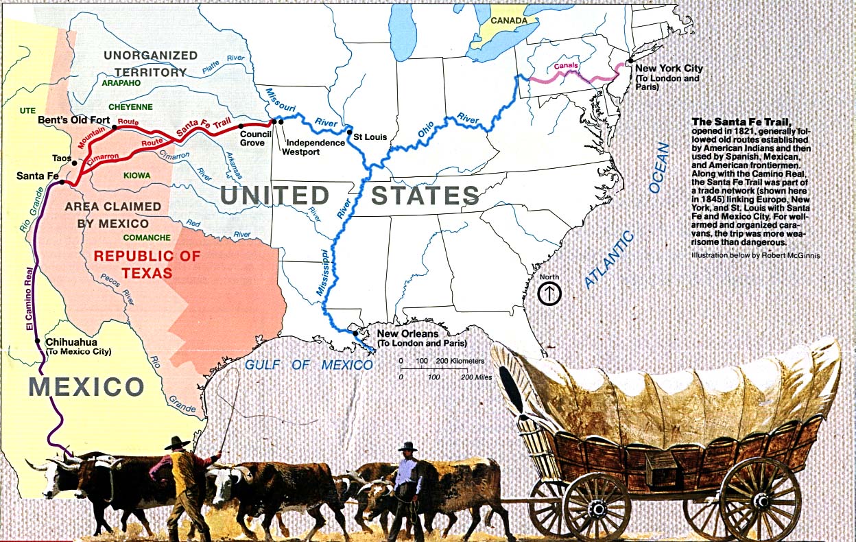
Amache Ochinee Prowers, also known as Walking Woman (c. 1846–1905), was a Native American activist, advocate, cattle rancher, and operator of a store on the Santa Fe Trail. Her father was a Cheyenne peace chief who was killed during the Sand Creek massacre on November 29, 1864, after which she became a mediator between Colorado territorial settlers, Mexicans, and Native Americans during the 1860s and 1870s. She was inducted into the Colorado Women’s Hall of Fame in 2018…Amache, a full-blooded member of the Southern Cheyenne tribe, was born possibly in the summer of 1846 during a forced march of her tribe across the plains of Southeastern Colorado…John Wesley Prowers was a trader who visited and then employed by William Bent at Bent’s Fort. He saw Amache perform a Cheyenne dance around 1860. Later, he asked Chief Ochinee if he could marry Amache the following year. They were engaged in a typical Cheyenne courtship, which involved exchanging gifts. In 1861, at the age of 15 or 16, she married 25-year-old John Wesley Prowers, a cattleman and trader. After their marriage, they spent a few months in Westport, Missouri, where she learned the traditions of white women. She experienced prejudice, being called “that Indian woman” by John’s brother-in-law, John Hough. Then they lived at Bent’s Fort…John and Amache worked together in their business and personal pursuits and settled along the Santa Fe Trail in Boggsville, Colorado in 1867. They lived in a 14-room adobe house, which is a Boggsville Historic Site in Bent County, where they raised nine children…Her father helped negotiate a treaty between the government, Cheyenne, and Arapaho to safely camp along Sand Creek during the winter of 1864–1865. At that time, he had met with the Territorial Governor, John Evans. Colonel John Chivington certified that Lone Bear was a man of good character and a “friendly Indian.” Before the attack, the Prowers family, including Amache, were held hostage to prevent them from warning Cheyenne at the Sand Creek winter camp site of the iminent attack…On November 29, 1864, the Cheyenne camp at the Sand Creek was attacked by 600 soldiers of the Colorado Volunteer Cavalry and her father, Peace Chief Ochinee (Lone Bear) and 160 other people, most of whom were children and women, were killed. Her mother was able to escape…Amache went later to the Congress with her husband and testified to seek justice for the Cheyenne. She and her two oldest daughters and her mother each received reparations by the United States government in the form of 640 acres of land along the Arkansas River. Amache used her land to expand her family’s cattle ranch…Located on the Santa Fe Trail, she and her husband ran a store, hotel, post office, county office, and school where people of Euro-American, Native American, and Latin descent met and exchanged information. Prowers spoke English, Spanish, and the language of her birth, Cheyenne.


Here’s a look at the 7-Day Colorado precipitation map through August 23, 2026 from the High Plains Regional Climate Center. Precipitation in the South Platte Basin along the Continental Divide of the Americas ranged from 0.15” to 1.20”.

Here’s the 7-Day percent of normal precipitation map through August 23, 2026 from the High Plains Regional Climate Center. Precipitation in the South Platte River Basin along the Continental Divide of the Americas was 50% to 130% of normal.

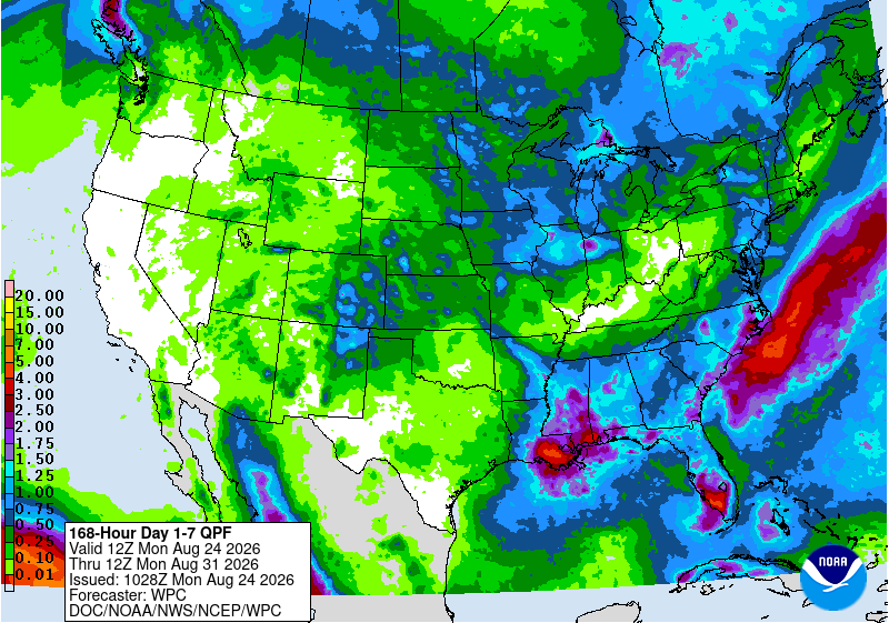
Below is the 7-day Quantitative Precipitation Forecast for the week of August 24, 2026. Precipitation is anticipated for the mountains of the South Platte River Basin and may total up to 1.50″.
Below are the 8-14 day outlooks from the Climate Prediction Center, issued August 23, 2026, for temperature and precipitation, for the week starting August 31, 2026. The CPC expects above normal temperatures and near normal precipitation for the mountains of the South Platte River Basin.


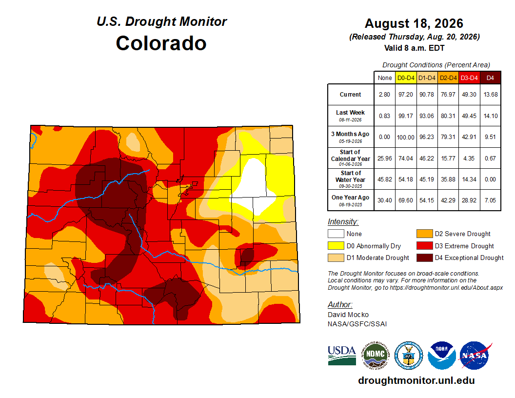
Below is the Colorado Drought Monitor map from August 18, 2026. There were one class improvements in Douglas, Arapahoe, Adams, Elbert, Morgan, Weld, Logan, and Sedgwick counties. Drought and abnormal dryness covers 97.2% of Colorado. The South Platte Basin is experiencing Abnormally Dry, Moderate, Severe, Extreme, and Exceptional drought conditions.
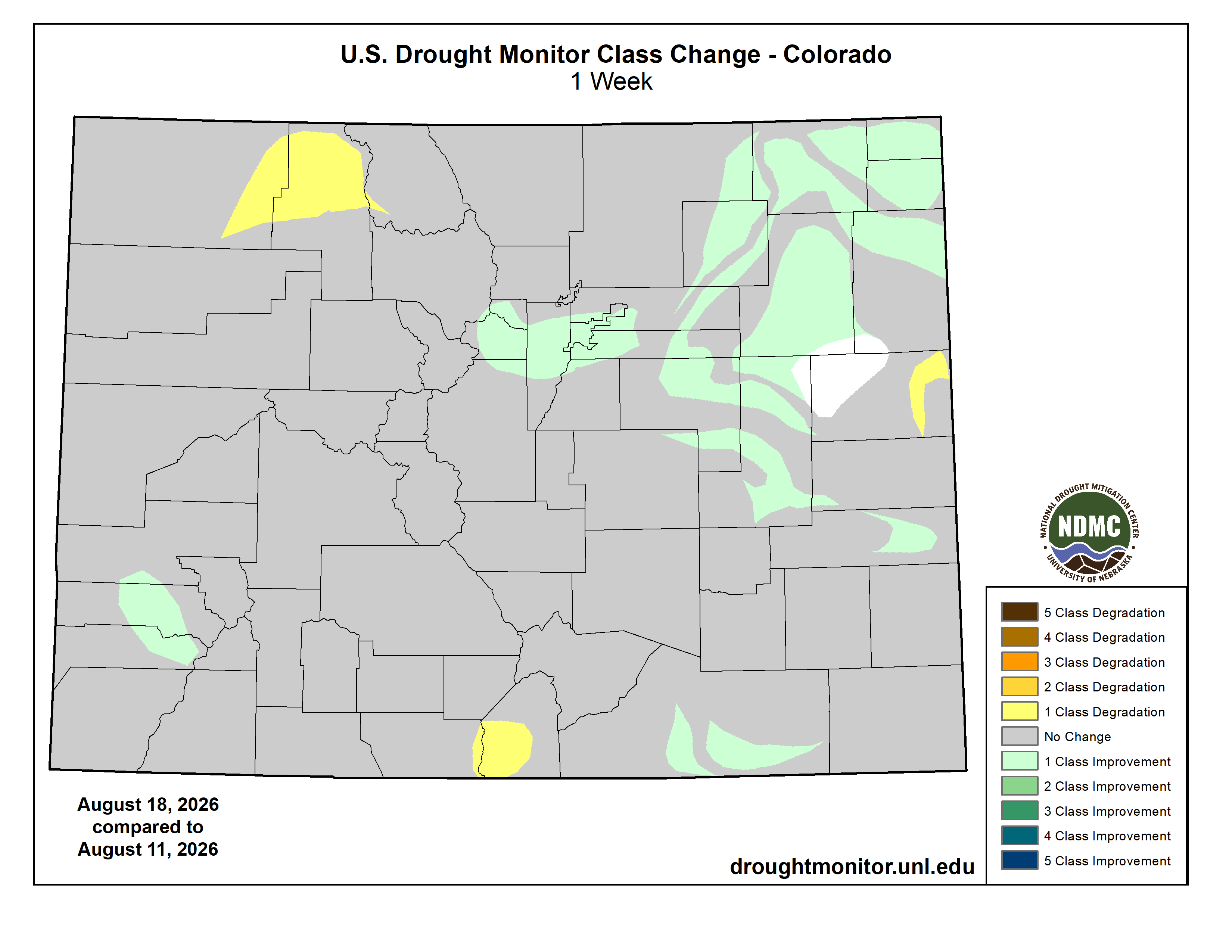
Below is the Colorado Drought Monitor one week change map ending August 18, 2026.
Here’s the US Drought Monitor Map from last week along with the one week U.S. change map.
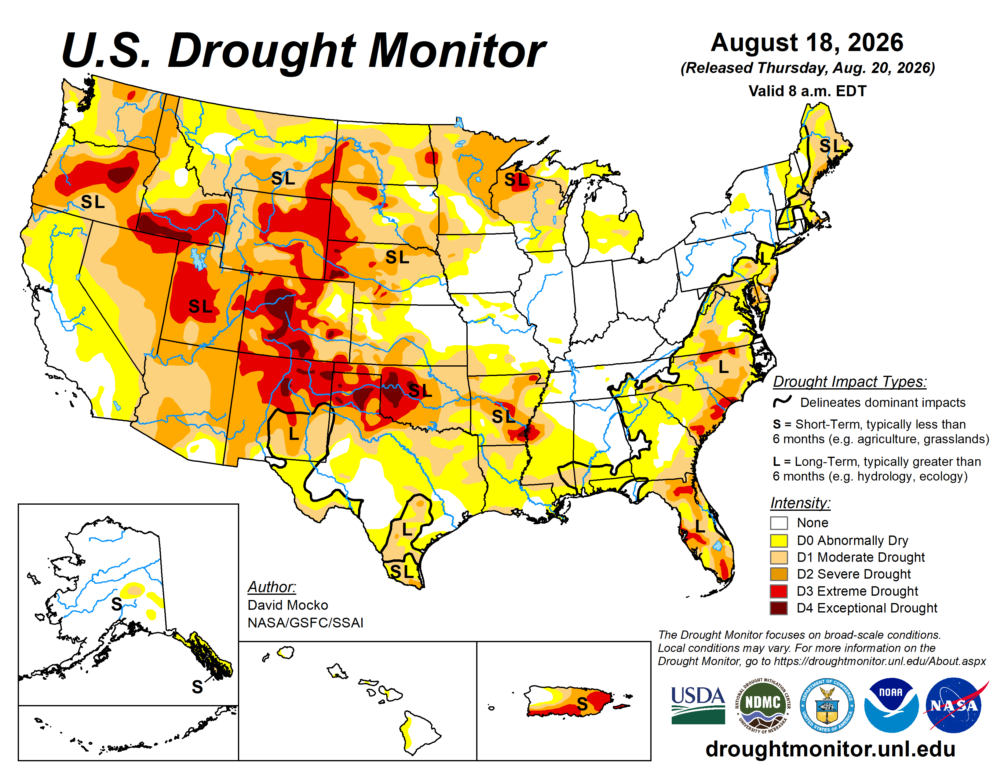
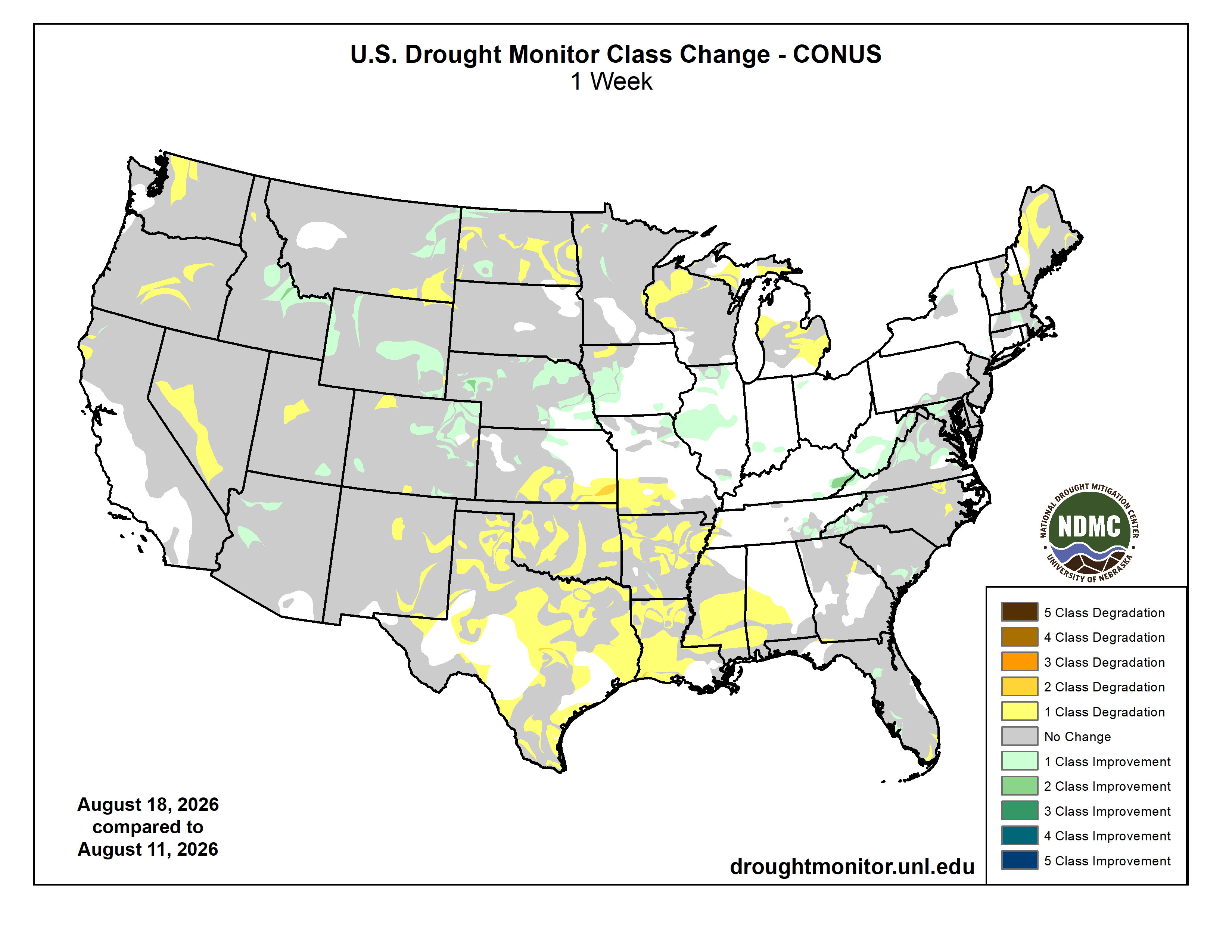
Finally, last week the Climate Prediction Center issued their latest Seasonal Outlooks, through November 30, 2026. The CPC expects above normal temperatures, above normal precipitation, and drought improvement, along with some drought removal near Nebraska, in the South Platte River Basin.


