Feds release Colorado River plan, and no one’s very happy about it — Jonathan P. Thompson (LandDesk.org) #ColoradoRiver #COriver #aridification

Lake Powell and Wahweap Marina back in August 2021, when the surface level was at about 3,549 feet. It’s now at 3,522 feet, just above the all-time low reached in April 2022. Jonathan P. Thompson photo.

Click the link to read the article on The Land Desk website (Jonathan P. Thompson):

August 4, 2026

Last week, the federal Bureau of Reclamation released their final environmental impact statement for proposed alternatives for managing the Colorado River and its major reservoirs over the next decadeThe preferred alternative is not a specific operating plan, but is the “decision framework” that will provide a structure within which those plans can be developed at two-year intervals. The operating guidelines for the 2027 water year, which begins Oct. 1, are expected to be released later this month.

The feds stepped in after the seven Colorado River states failed to agree on a new plan to replace the 2007 Interim Guidelines and the 2019 Drought Contingency Plans, both of which expire at the end of September. The states will continue to negotiate, and a seven-state consensus deal would take precedence over the federal plan.

Udall/Overpeck 4-panel Figure Colorado River temperature/precipitation/natural flows with trend. Lake Mead and Lake Powell storage. Updated through Water Year 2025. Note the tiny points on the annual data so that you can flyspeck the individual years. Credit: Brad Udall

Those plans were aimed at bringing overall demand back into balance with supply, which is not easy given that a warmer and drier climate is continually diminishing the already over-allocated river. While the document appears to have been completely scrubbed of any references to “climate change” or “global warming,” it does obliquely acknowledge that the cause of the current woes is a heating planet with passages like this one: “Imbalance between water supply and demand will be exacerbated by increasingly likely low-runoff conditions: The Basin is experiencing increased aridity due to climate variability, and long-term drought and low-runoff conditions are expected in the future.”
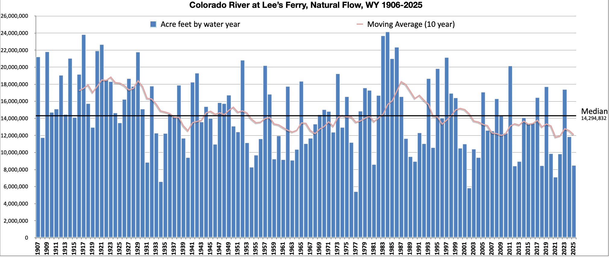
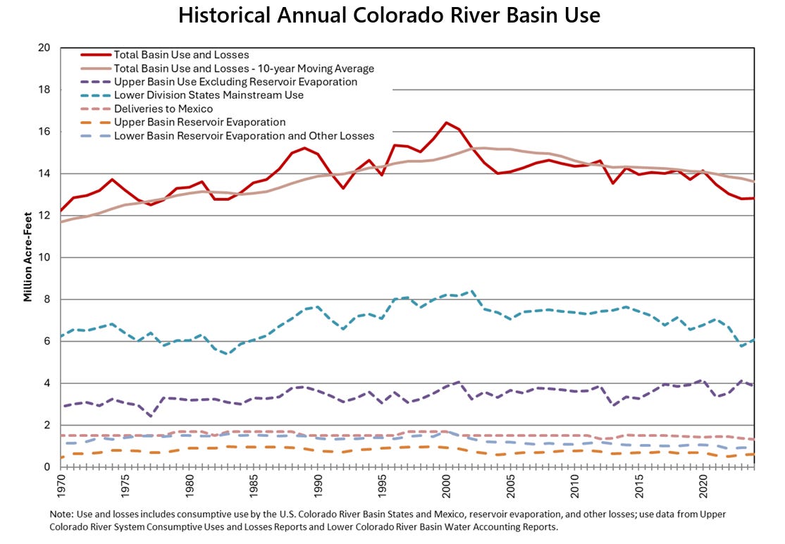
The natural flow flow at Lees Ferry, which is a calculation of what the Colorado River’s flow would be without any upstream dams, diversions, or human consumption. Land Desk graph using Bureau of Reclamation data.

While the supply-demand balance is the central objective, a secondary one is to “protect critical elevations” at Lake Powell, which is to say they will take significant measures to keep the surface level from dropping below 3,500 feet, which provides a 10-foot buffer above minimum power pool. This not only preserves hydropower output, but it also avoids relying on the river outlet works for sustained releases. Meanwhile, the feds didn’t even consider proposals to drain Lake Powell or to build bypass tunnels around Glen Canyon Dam to allow for low-level water releases. [ed. Note that the USBR EIS is constrained by the “Law of the River”, the suite of agreements and legislation that details what the agency can do to operate the river.]

Sorry, Ed. I’d like to help, but there’s not a whole lot of interesting things to say about this!

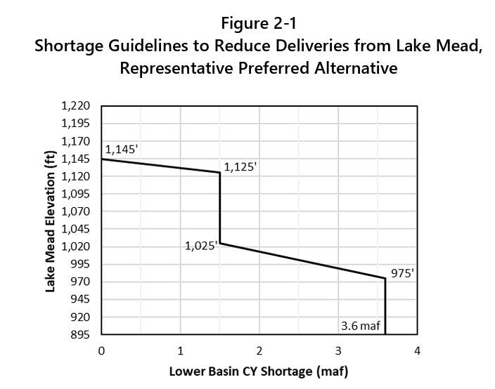
The release was met with much pomp and circumstance, along with a lot of hand-wringing and teeth-gnashing, though it didn’t contain any major surprises or changes from the draft EIS released earlier this year. The big takeaway, or at least the most talked-about one, is that the Upper Basin states will not be subjected to mandatory water use cuts, though they are being asked to cut about 200,000 acre-feet annually on a voluntary basis. The Lower Basin states, meanwhile, will be required to cut their consumption, perhaps by as much as 3.6 million acre-feet per year, depending on reservoir levels. That’s nearly half of those states’ Colorado River Compact allotment.

The cuts would be distributed based on water right priority, which would hit Arizona the hardest. That’s not because Arizona’s rights are junior to everyone else’s, but because their biggest straw — the Central Arizona Project — has junior rights, which the state accepted in exchange for federal funds to help build the thing and to help power its energy-sucking pumps.

Lower Basin leaders are, generally, livid. Arizona Gov. Katie Hobbs said the feds’ plan “still contains unacceptable options that include the federal government forcing Arizona to take the majority of draconian water cutbacks.” Nevada Gov. Joe Lombardo said the plan “seeks to impose unrealistic reductions on Nevada and our water users … {that} could have devastating economic and environmental impacts … .”

The response from the Upper Basin has been a more measured and mixed, but is predominantly one of relief at being spared mandatory cuts. But any celebration is tempered by the fact that nature is forcing its own cuts in the Upper Basin; irrigation canals are shutting down all over the place, long before the growing season is over, and some irrigators have received only a fraction of their usual allotment this year. Plus, the plan leaves open the possibility of draining Upper Basin reservoirs such as Flaming Gorge, Blue Mesa, and Navajo to buoy levels at Lake Powell. That will affect recreation and leave less water for irrigators and other users in the Upper Basin.

Meanwhile, advocacy groups are generally unhappy about the plan’s short-term approach, its focus on saving dams rather than the river, its willful ignorance of climate science, and its failure to force cuts on all river users. Even more dismaying is the fact that it doesn’t even cap Upper Basin consumption at current levels, implicitly allowing new diversions and water projects that would throw supply and demand further out of balance. “The Colorado River needs consequential and systemic change that confronts the ecological, political, and legal chaos caused by climate change and Glen Canyon Dam, but Reclamation’s plan is just ‘lather, rinse, repeat’ of past failed policies,” said Gary Wockner, of Save The Colorado, in a written statement.

This sentiment reveals a sort of paradox on the Colorado River: All of the water that flows to the Lower Basin and the industrial-scale alfalfa farms in the Imperial Valley also runs through the Grand Canyon, keeping that ecosystem healthier. Meanwhile, any water that the Upper Basin consumes or that is held back in Lake Powell to protect the dam’s integrity is water that doesn’t flow through the canyon.

There’s no indication that the Trump administration is punishing the Lower Basin states, however. It’s far simpler logistically to distribute and enforce mandatory consumption cuts in the Lower Basin because there are fewer diversion points, each of which is far larger than in the Upper Basin. Also, the 1928 Boulder Canyon Project Act made the Interior Secretary the “water master” on the Lower Colorado River, giving the feds greater authority to order shortages.

One question that remains unanswered is how reduced releases from Glen Canyon Dam would play out in the context of the Colorado River Compact, which dictates that the Upper Basin “not cause the flow of the river at Lee Ferry to be depleted below an aggregate of 75 million acre-feet” for any 10-year period. There’s a high likelihood that the 10-year aggregate flow will drop below 75 maf in the next year, giving Arizona possible grounds to sue and putting the interpretation of the clause into the hands of the Supreme Court.

Here are a few more details from the final EIS:

  • Glen Canyon Dam annual releases, which will be determined on Oct. 1, will range from 6 maf to 12 maf. This could drop as low as 5 maf if necessary to defend the “de facto deadpool” Lake Powell surface level of 3,500 feet. That would reduce flows in the Grand Canyon to below 7,000 cubic feet per second, and cause Lake Mead to drop further.

  • The maximum shortages/cuts for the Lower Basin would be 3.6 maf distributed as such:
  • Arizona: 1.96 maf
  • California: .9 maf
  • Nevada .21 maf
  • Estimated shortage impacts by water user type under various shortage conditions:

Lower Basin 2027-2028:
Tribal: 209-346 kaf
Domestic: 313-858 kaf
Non-Tribal Irrigation: 2-70 kaf

Lower Basin (2029-later)
Tribal: 241-576 kaf
Domestic: 277-1,472 kaf
Non-Tribal Irrigation: 6-829 kaf

  • Acreage range of Indian Trust lands in the Lower Basin that would be fallowed under various shortage conditions:

AZ: 6,535 to 67,375
CA: 0
NV: 0

  • An alarming quote about how junior water rights holders are going to face shortages no matter what: Under the preferred alternative, “… for all Arizona, California, and Nevada junior entitlements (AZ CAP NIA-A and NIA-B; AZ CAP Indian, M&I, and 4(I); CA P4; and NV P8 priority groups) there are no potential futures in which >80% of normal domestic water delivery occurs.”
  • Lower Basin Tribal water users with present perfected rights would receive at least 80% of normal water deliveries in at least 90% of years across 2027-2039.
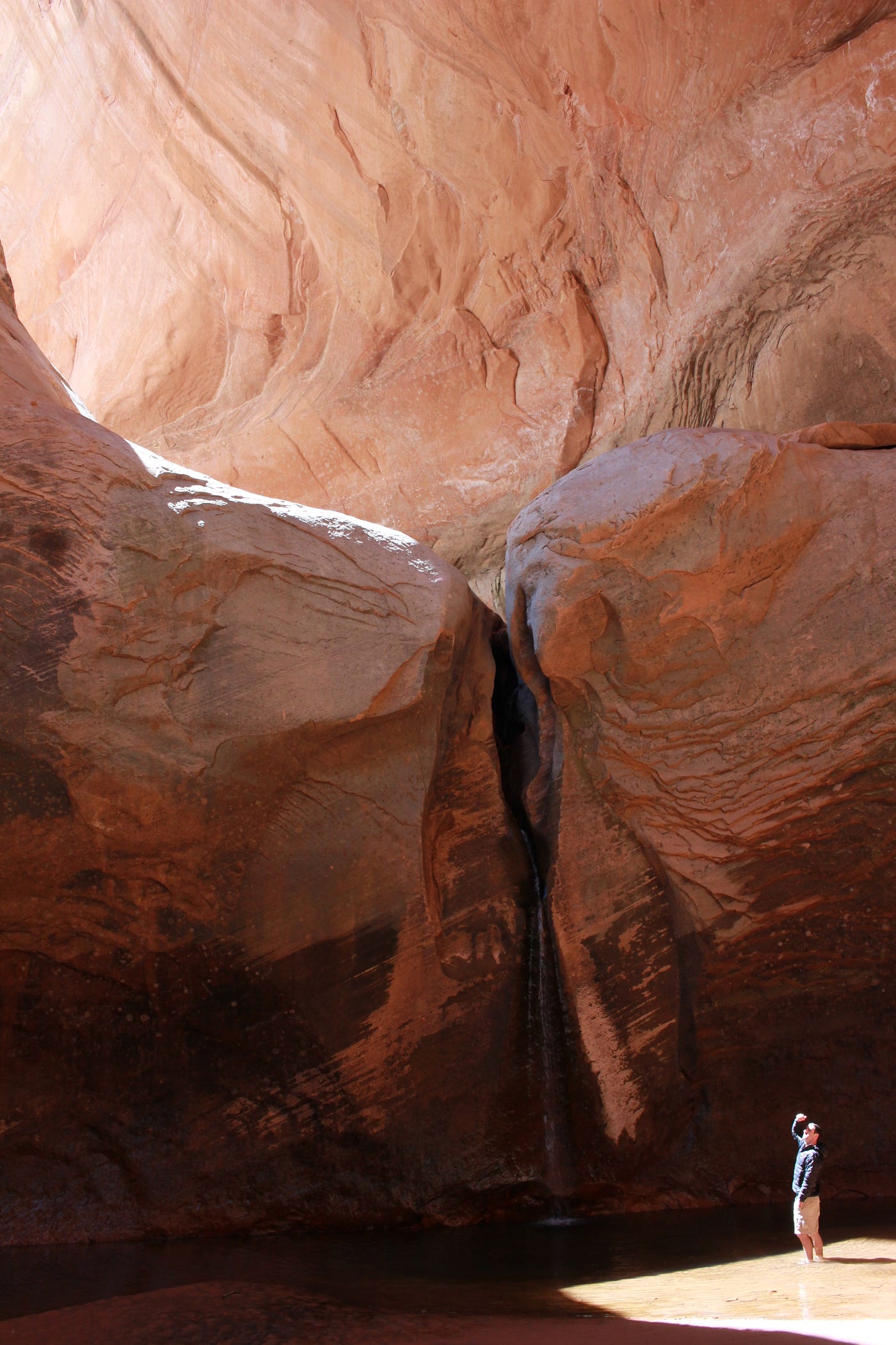
Glen Canyon Institute Executive Director Eric Balken observing the Cathedral. Photo credit: Glen Canyon Institute
  • During 75% of years under preferred alternative, Lake Powell’s level would be below 3,550 feet during at least 90% of months, meaning Cathedral in the Desert would be visible and accessible.

The EIS’s authors summed up the challenges with all of this — and the perils that may lie ahead — in one paragraph, writing:


A Colorado River glossary and primer — Jonathan P. Thompson


Map of the Colorado River drainage basin, created using USGS data. By Shannon1 Creative Commons Attribution-Share Alike 4.0

#ClimateChange made the West’s snow drought far more likely—but it’s still not the new normal — Mitch Tobin (WaterDesk.org)

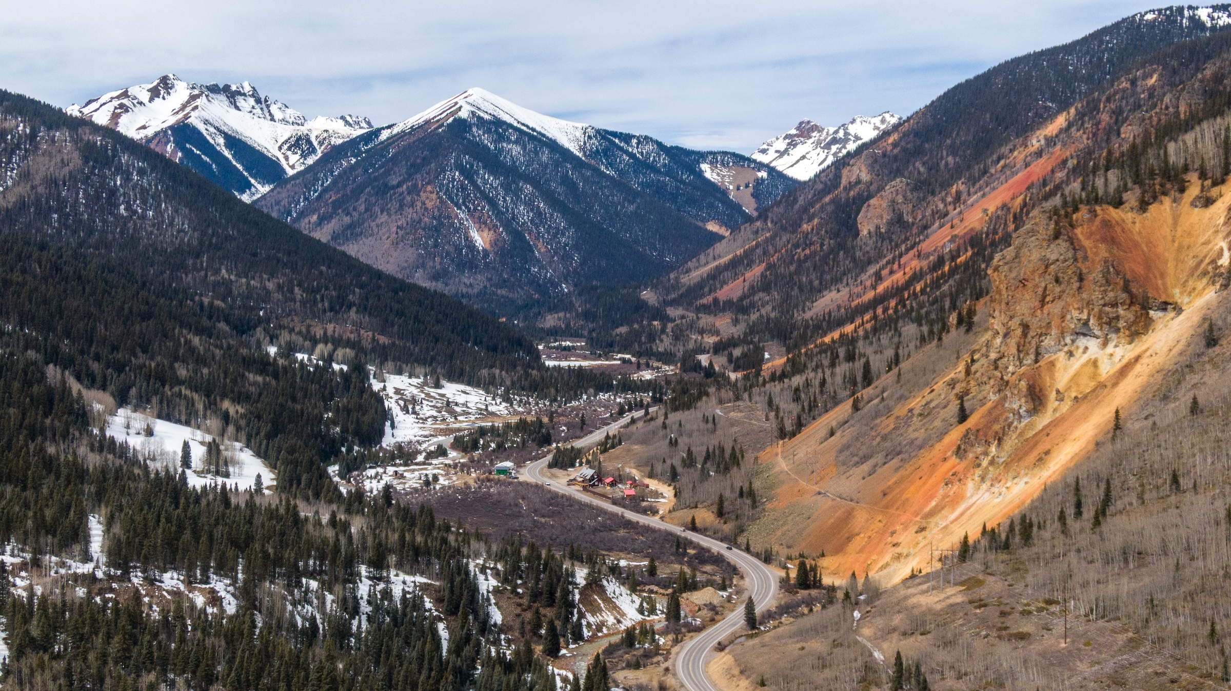
Last winter’s meager snowpack near Silverton, Colorado, on March 14, 2026. Researchers analyzed Western snowpack data from the next day, March 15, to assess the influence of climate change on the historic snow drought and to project how future warming could affect the likelihood of similar events. Photo: Mitch Tobin/The Water Desk.

Click the link to read the article on The Water Desk website (Mitch Tobin):

August 3, 2026

The American West’s historic snow drought in 2026 depressed skiers, heightened wildfire risks and constrained already scarce water supplies. 

Was this extreme event just a stroke of bad luck in a region where snowfall naturally varies from year to year? 

Or did the record-low snowpack bear the fingerprints of climate change?

new study in the Proceedings of the National Academy of Sciences concludes that global warming more than quadrupled the odds of the West’s snow drought when compared to the preindustrial climate, before human greenhouse gas emissions began heating the planet.

In the Upper Colorado River Basin, where snowmelt supplies most of the water in a river that serves tens of millions of people and irrigates millions of acres of farmland, climate change’s estimated influence was even greater. Researchers concluded the snow drought was about 14 times more likely, although that estimate is more uncertain because the event was so exceptionally rare, even in today’s warmer world. 

Looking ahead, scientists project that snow deficits as extreme as the West’s 2026 drought could become the norm by the end of the century if emissions continue to climb.

In the 2020s, a Westwide snow drought as bad as last season’s has about a 1-in-10 chance of occurring each year, so it’s still not the new normal. But the odds rise dramatically under the “moderately high” emissions scenario used in the study: the annual probability more than triples to about 1-in-3 by the 2050s and soars to nearly 9-in-10 in the 2090s.

Hydrologist Adrienne Marshall. Source: Colorado School of Mines.

I spoke with the study’s lead author, Adrienne Marshall, a hydrologist and assistant professor at the Colorado School of Mines. Excerpts from our July 23 conversation are below, edited lightly for clarity and brevity.

“Where we are is serious,” Marshall said. But she emphasized that a West where profound snow droughts are routine is not a fait accompli, because future greenhouse gas emissions are not set in stone. 

“These are not predictions of what will happen in the future,” Marshall said. “I think this type of work is most useful if it is motivational and not discouraging.”

How would you summarize the most important findings of the study?

I think our most important findings here are that we were able to look at the extent to which this last year’s unusually low snow conditions were attributable to human-caused climate change. 

We found that across the Western U.S., the low snow conditions we saw were about four and a half times more likely because of climate change that we’ve experienced to date. That is equivalent to a water volume that’s about the size of Lake Mead. If we think about a rare event in a world without human-caused climate change and a rare event in the world we’re living in, the amount of snow we’re missing is about the size of Lake Mead. 

In the Upper Colorado River Basin, the snow drought was more extreme, so we find a higher “risk ratio,” meaning an increased probability due to human-caused climate change.

Did these findings surprise you?

The thing that surprised me was the magnitude. I wasn’t surprised to see that these events seemed to be attributable to human-caused climate change. I was a little bit surprised to see numbers that were quite as big as they were.

The study says that climate change made the snow drought about 4.4 times more likely. Could you explain that further? What exactly does that mean?

To dig into what that “more likely” means, people might have heard before of things like a 100-year rainfall event or a 100-year flood event, where we can say we would expect an event like this one to have maybe a 1% chance of happening each year. That would be a 100-year event. 

So we took that approach with unusually low snow conditions. We used some models that were run for the 1850 to 1900 period, so that’s our period without human-caused climate change. And we saw that, in that period, the snow conditions we had this year would’ve been about a 1-in-30-year event. Then when we use those same models for about a 20-year period encompassing the world we’re living in now, we see it’s about a 1-in-7 event. And then we divide those two numbers, so 30 divided by about seven, to get that approximately four and a half times more likely value.

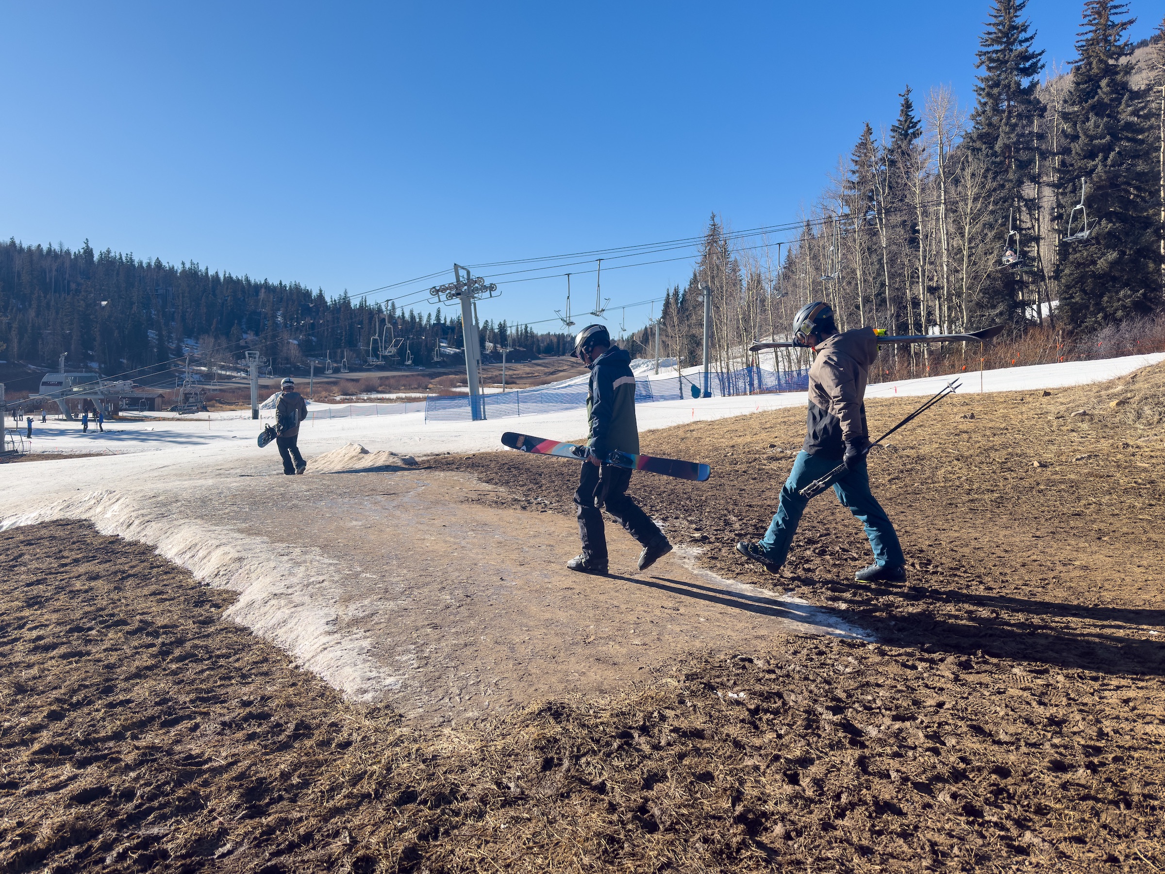
Skiers at Purgatory Resort in southwest Colorado on February 8, 2026. Photo: Mitch Tobin/The Water Desk.

Why is climate change making snow droughts like this much more likely?

In the most basic sense, there are two things that can cause snow drought. One is warm temperatures, and then the other one is just not getting any precipitation at all. So when we have warm temperatures, we get precip that falls as rain rather than snow. 

When we think about the impacts of climate change, we have a lot of certainty about increasing temperatures. We have very good evidence that temperatures have increased, and models agree really well that they expect temperatures to continue to increase. That also aligns with our basic physical understanding of the Earth system. 

Precipitation is a lot more uncertain, so it’s harder to see clear trends in winter precipitation so far, and models tend to disagree more about how we think precipitation will change—at least in the Western U.S. So when we think about the impacts on snow, those warming temperatures giving us less snow are kind of a really clear climate signal while the uncertainty in the precipitation can muddy the waters, relatively speaking.

With this snow drought, it sounds like it was really primarily driven by temperature.

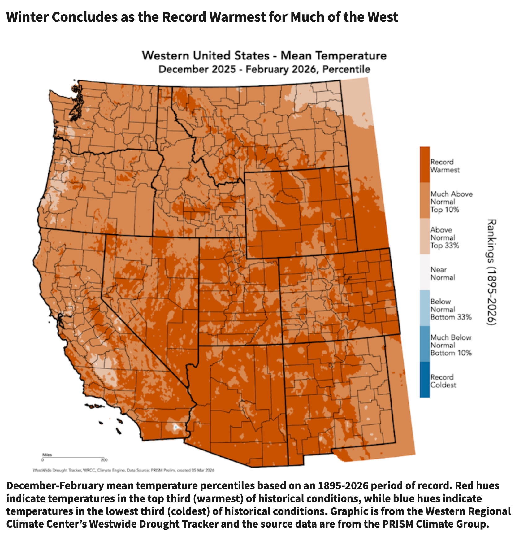
We haven’t quantified what was the contribution of temperature versus precip. But if we look at what was happening across the West this year, temperatures were really unusually high over much of the winter, with sort of an extraordinary heat wave in March. Precipitation was low, but not extraordinary across most of the Southwest. And then as we look up into the Pacific Northwest and British Columbia, we tend to see precipitation that was a little bit above average up there. Temperature: kind of extraordinary. Precipitation: more within a range of variability that we’re used to seeing.

Source: National Integrated Drought Information System.

The date you used was March 15. We often hear about people using April 1 as the key milestone for snow water equivalent (a measure of the snowpack’s water content). Why did you use March 15? 

We used March 15, in large part, because this year it looks like that was approximately peak snow water equivalent—when we sum up how much snow was sitting there across the West. We thought that was a useful indicator of how much snow does a water manager have to work with, even if it was earlier than usual. I think doing the same analysis with April 1 would be interesting, too. The statistics get a little bit more challenging for more rare events. Because of that March heat wave, I think that we would see that April 1 snow would likely have been even more extreme, which could make the statistics a little bit more challenging—increase uncertainty, essentially.

The study also looks specifically at the Upper Colorado River Basin. Could you explain what the findings were for that portion of the West?

In the Upper Colorado River Basin, this event was especially extreme. Snow was really particularly low. Our best estimate here is that, in the world we’re living in now, the snow conditions this year were about a 1-in-140-year event in the Upper Colorado River Basin, so quite rare. In the world without anthropogenic (human-caused) climate change, we think that it would’ve been maybe a 1-in-2,300-year event. Once we start estimating events quite that rare, we get big uncertainty ranges. Then when we divide those two, we see that in the Upper Colorado River Basin, we think that this event was about 14 times more likely because of human-caused climate change. But there our uncertainty is really large.

The Gold Mountain Fire burns near Ridgway, Colorado, on July 1, 2026. Photo: Mitch Tobin/The Water Desk.

The study also looks ahead to the future and the climate continuing to warm. What should we expect going forward?

These results were quite sobering. We look at what we would expect to happen in a moderately high greenhouse gas emissions scenario. What we see is for the Western U.S., we estimate that an event this bad had about a 10% chance of occurring each year in the 2020s. By the time we get to the 2050s, that slightly more than triples. So every year we would have about a 30% chance of having snow at least this low. And then by the 2090s, that becomes 87% of years, so we would expect that most of the time the snow would be at least this low Western U.S.-wide. In the Upper Colorado River Basin, we also see increases, but because this event was so extreme, we never see it becoming the norm in the 21st century. 

The really important caveat here is that these are not predictions of what will happen in the future. These are our estimates of what we would expect in a particular greenhouse gas emissions scenario. And there are other greenhouse gas emission scenarios that are better. We could emit fewer greenhouse gases than this and do better than what these projections suggest.

It seems like pretty clear evidence for the benefit of reducing emissions for the snowpack.

The analysis I’d like to do is to look at the other scenarios and say, “OK, how much better would it be?” We don’t quite have the data to make exactly that apples-to-apples comparison at the moment, but there’s ways to pursue that . . . Based on our understanding of this system, I would strongly expect that if we look at a lower-emissions scenario, we would not see those probabilities climb quite so high.

We often hear the question, “Is this the new norm or is this the new normal?” These data suggest that it’s not right now. Western U.S.-wide, it could be by end of century. So I do look at that and think, “Let’s try to avoid that.”  [ed. emphasis mine]

Low water at Blue Mesa Reservoir, along Colorado’s Gunnison River, on July 1, 2026. Photo: Mitch Tobin/The Water Desk.

What do you hope the public and decision-makers take away from this study and the projections?

There’s three big takeaways I have in mind. One is that I hope it’s clarifying in terms of where we’re at right now in terms of the impacts of climate change. It’s relatively new that we can look at a specific snow year and say, “Here’s how much this was caused by anthropogenic climate change.” 

The second impact is I hope it’s useful for adaptation so that individuals and utilities and water managers can look at this snow year and think seriously about what we might like to do to adapt to more snow years like this. 

And then the third thing is to help motivate us to see if we can push emissions trajectories downwards and do what we can to avoid having more snow years like this to the extent possible.

To learn more about the opposite of snow droughts—known as snow deluges—see my 2024 Q&Awith Marshall about her research on California’s epic snowpack during the 2022-2023 winter.

This story was produced and distributed by The Water Desk at the University of Colorado Boulder’s Center for Environmental Journalism.

Upper Colorado River basins. (The border of Wyoming and Colorado is mislabeled.) (U.S. BOR)

#Aurora using smart meters to crack down on lawn watering violators — Michael Booth (Fresh Water News) #SouthPlatteBasin

South Platte River Basin via Wikipedia

Click the link to read the article on the Water Education Colorado website (Michael Booth):

August 5, 2026

Aurora Water doesn’t much care which two days in a week you water your lawn, amid this historic drought.

But if your irrigation system starts up on a third day in the same week, the water world equivalent of a Flock camera is watching. The “smart” meters on every Aurora property automatically sense a spike in water use, and alert Aurora Water to confirm the violation and send out a warning or fine.

With updates at 15-minute intervals, the meters also detect irrigation watering during hot daytime hours when that’s against the rules.

The water surveillance, which Aurora Water officials acknowledge many of their customers might not realize exists, is one key to Colorado’s third-largest city so far achieving its water-saving goals in a year with record-low snowpack and abysmal streamflows into mountain reservoirs. Aurora says its 400,000 residents are using 27% less lawn water than in 2025, and managed a 9% cut from combined indoor and outdoor use.

Maintaining or even improving those savings is crucial as Aurora Water’s reservoir system sits at 49% full at a time when it should be above 80%.

Denver Water, meanwhile, has seen only about a 5% cut of water use compared with its previous five-year average among 1.5 million city and suburban customers. When Denver Water enacted twice-a-week watering restrictions in the spring, it set a target of a 20% cut from five-year average use.

Denver’s customers are doing better when using Aurora’s comparison with 2025 only, Denver officials said.

“Versus 2025, total water use is currently down about 7% and outdoor use is down about 16%,” said Travis Thompson, Denver Water communications manager.

The state’s largest water agency says it is encouraged by other statistics showing customers are using 21% less lawn water than they would have expected in the run of 95- to 100-degree days the Front Range experienced in July. In a summer that sits in the top 1% hottest and driest on record, the agency says, that’s a laudable savings mark.

One difference: Aurora Water spent millions of dollars in capital getting smart meters on every customer tap, while Denver Water chose to spend more of its capital speeding up replacement of aging, dangerous lead water delivery lines. Denver’s enforcement of drought restrictions to date has relied on thousands of neighbor complaints about properties watering more than twice a week, during restricted daytime hours or other violations.

“We have a far bigger tool than they have for being able to detect when people are using water irrigation water when they’re not supposed to,” said Shonnie Cline, Aurora Water’s deputy director of water internal and external relations.

Watchdog groups such as the American Civil Liberties Union in the past have raised questions about privacy invasions from smart home devices, including electric and water meters monitored by utilities. Especially by combining information from multiple meters, hackers or other bad actors could watch patterns and learn when people are home or away, are cooking, taking showers or other personal habits.

Cline said a better analogy than a controversial Flock camera is to see a smart water meter as a personal fitness tracker. “It gives you data and you are able to identify patterns that can improve your overall health if you make changes,” Cline said.

Aurora points out the smart meters for every customer work both ways, as a protection from leaks and potential property damage. Customers are able to log on and track their own use at the same time the city sees it, and could recognize a home leak while away on vacation, for example. During droughts, the meters will be one key to helping maintain reservoir storage for the benefit of the whole community, Cline said.

“There is a definite footprint that goes along with the data that indicates irrigation is taking place,” Cline said. “We have that pretty locked in where we can see when somebody’s irrigating, and so that’s why it’s interesting, because even when we send a warning, people are like, ‘But I didn’t!’ And then we’ll show them the data, and they’re like, ‘OK, I can’t argue with you, right?’ “

Denver Water, while enjoying higher water storage rates at its mountain reservoirs that have seen better snowpack, is not satisfied with customer savings rates and is now shifting somewhat from “education” to “enforcement” mode.

Denver had sent out nearly 3,600 warning letters but only five fines by the beginning of August. Fines will ramp up now that customers know what the rules are and Denver Water knows more about where the problem customers are, officials said.

Aurora Water, by contrast, has issued 234 fines after sending out more than 2,500 warning letters, including 10 of the highest $2,000 fines to businesses and large irrigation consumers. Only three customers were issued a second fine at the $250 residential level, Aurora Water said, and none had been issued a third fine. Aurora’s fines total more than $70,000.

Now that Denver Water has weeks of data on actual water use during drought restrictions, the agency can focus its communications on suburban areas with bigger lawns that haven’t cut back, said Greg Fisher, the utility’s manager of demand planning. Some of those suburban customers have no idea it’s Denver Water that collects their mountain runoff and delivers it to their local water utilities.

With only 5,000 advanced meters installed for 250,000 taps, Fisher said, word of mouth enforcement confirmed by onsite visits from Denver Water employees will continue to be the standard for warnings and fines.

“We continue to rely on, and I think it’s a pretty inventive idea, of letting our customers report water waste violations,” he said. “Even with the water people out on the street, we can’t be everywhere. So giving our customers the ability to report has been pretty powerful and I think effective for us.”

Denver Water officials do not anticipate asking their board this season to approve the next drought stage that would take lawn watering down to one day a week and add other restrictions. Denver Water would have to change its rate structure again to charge more for lawn watering that does occur to make up for loss of revenue from restrictions.

Plus, the utility thinks it’s a longer-term challenge to convince customers to change habits and stay “on board” with drought restrictions in the middle of what could be a multiyear crisis, Fisher said.

“We have a long game,” Fisher said. “This thing’s going to last a minimum of 12 more months, in my opinion, save for some sort of record-breaking snowfall this winter. So we’re in it for the long haul. I think we need to continue to up the message as we see conditions change. But at the same time, we really need to support our customers and have them stick with us for that extended period.”

People are capable of change, Denver Water officials said. The last drought this severe for Front Range customers was 2002.

“Our customers are using 100 million gallons less per day this year than they did in 2002, which is just stunning,” Fisher said. “And that translates to being actually 14% higher in our reservoir storage now than we were in 2002, because of our customers’ efficiency efforts over the last quarter century. We’re feeling really good about that. And that’s with significantly more population … 200 to 250,000 more people.”

More by Michael Booth

Romancing the River: Let us gather by the river…. — George Sibley (SibleysRivers.com) #GunnisonRiver

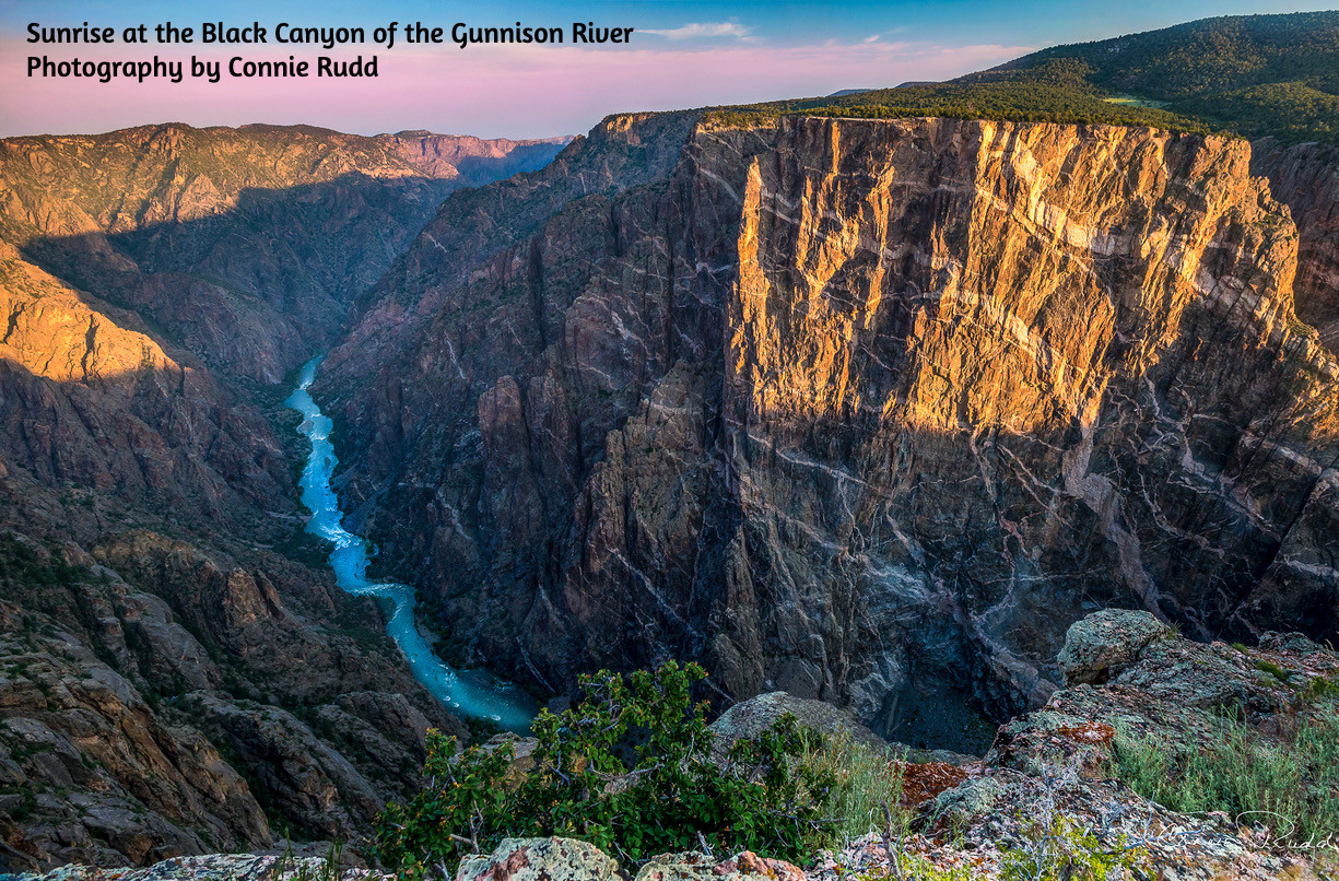
Sunrise at the Black Canyon of the Gunnison River. Photo credit: Connie Rudd

Click the link to read the article on the Sibley’s Rivers website (George Sibley):

July 28, 2026

Every so often it just seems like a good idea to drop out of the wrangling over the future of water in the arid west and – just go down to the river itself. A good friend abetted this by taking me along on a float down the lower Gorge of the Gunnison River. My friend was fishing; I was just along for the ride, and reflecting on my 60th anniversary of first moving to the Gunnison River valleys and the Colorado River Basin in 1966.

The Gunnison Gorge is a Bureau of Land Management Wilderness Area just downstream from the Black Canyon of the Gunnison River National Park. In 1966 I was – typically for a posturban American – unaware of where in the world I was, and didn’t know that the Gunnison River is one of the larger tributaries of the Colorado River, meeting the river in Grand Junction, Colorado, with a median contribution there of around 1.5 million acre-feet of water, with around another million acre-feet consumed by users in the Gunnison Basin, mostly for agriculture. This year, the river carries a fraction of that, less than a fourth of what passed for ‘normal’ through the 20thcentury.

Like most upper Colorado River tributaries, the Gunnison River alternates for most of its course between settled green mountain floodplain valleys, and canyons through which highways or railways might connect the valleys but otherwise humankind remains a visitor. The Gunnison’s Black Canyon is one of the steepest, deepest and narrowest canyons in the world, through which no highways or railways pass, and only a handful of adventurers float and swim through just to prove they can.

But the terrain levels out a little in the 14 miles of the Gunnison Gorge, creating long stretches of relatively broad slow-flowing stream, interrupted by rapids where side streams plunge in or rock falls have happened, creating a haven for fish and a gold-medal mecca for fishermen. Much of the Gorge is as narrow as the upstream canyon; dark rock walls on both sides rise steeply several hundred feet through most of it, with sand bars here and there for overnight camps and lunch stops. And everywhere in and along the river there are random rocks, ranging in size from a medicine ball to a small house; looking up the walls, one sees that more are awaiting some signal nudge to break off and fall, making one wonder what kind of mini-tsunami effect would happen if a raft were going by when a big one fell….

This is all what we call beautiful (recording it on our phones), but there is something else in these Gunnison canyons that goes beyond the pastoral scenic. You can get some of it in Connie Rudd’s sunrise image of the Black Canyon above. (Connie Rudd was superintendent of the Black Canyon National Park for a number of years.) The rock in the Black Canyon is not really black, but much of it is shadowed most of the time – not black so much as noir. The image shows the feature known as ‘The Painted Wall,’ due to its multicolored nature, but none of that is painted on; the river has exposed a cross-section of metamorphic rock that has been roiled, rolled, twisted, tilted, split and overturned, always under great pressure from earth layered on above and great heat from earth’s core hell. Rock that has had a hard life, not a comforting thought looking up at the walls from river level.

How did such a canyon system come to be? Gunnison Country geologist Tom Prather suggested that the Gunnison River, snowmelt from the already old Southern Rockies, had set its course looking as water does for the easiest routes through several hundred feet of fused volcanic ash from San Juan volcanoes to the south – on top of fused volcanic mud from the West Elk volcano to the north. And with its course already set in that stone, the forming river encountered the southern edge of a big blorp of metamorphic rock that was – well, just there. So rather than continuing to develop the open wide-V valley that most rivers are known for, the Gunnison River was captured by the hard rock with nothing to do but to cut an ever-deeper canyon that stayed steep and narrow with great hardrock walls in the Gunnison River’s Black Canyon and Gorge.

I am personally fascinated, in Rudd’s image, by how it shows the relative thickness of life as a layer contrasted with the geological layers. Look at the scrubby pinion-juniper and oak on the top of the Painted Wall. To call that layer of life on that mass of rock ‘skin-deep’ is almost an exaggeration. Our fossil-fueled efforts have expanded the layer of life to the seven miles or so above earth’s surface where we regularly fly, and the mile or so beneath the surface where we go to mine things we think we need, with nothing but microbial/incipient life above or below that. So life on earth occupies a layer 1/1,000th the diameter of the planet. If we remove fossil energy from the equation, the layer of earth and atmosphere occupied by life is probably measurable in thousands of feet rather than miles, less in total than a rounding error in the scale of the planet.

We’ve all heard the saying, ‘beauty is only skin-deep.’ But life is only skin-deep on the planet – ‘beauty’ is a term that works well in evaluations within that thin skin (as Connie Rudd’s image of the Painted Wall at sunrise is beautiful in its execution). But to be down in it, floating past rocks the size of small autos that came off those walls towering above – what’s there is some unarticulated and dynamic mystery beyond beauty. Maybe ‘awesome’ worked descriptively before that became a standard response to questions like ‘want to go for a beer?’ Maybe ‘Magnificent.’ ‘Stupendous.’ Or maybe just ‘brutal,’ if you’re floating along beneath it all; we don’t really get into its mystery until we’ve put it in terms in which we can feel something of the pain or ecstacy of what’s happened there.

Down in places like the Gorge that are beyond mere beauty and other ‘surface’ evaluations, I find my mind being stretched to the elastic limit over a concept like ‘nature.’ Or ‘god.’ The majority of us seem to be beyond a thoroughly churched ‘god’ (or panel of gods) as the creative force in the planet and its layer of life, but many of us seem to have just transferred to ‘nature’ that belief in some creative/destructive force larger than ourselves.

But it is not possible – for me, at any rate – to look up at these crumbling walls of tortured rock, some with trees struggling to grow in cracks in the rock until the roots split off the rock and tree and rock go in the river below with a wave that would smash a passing raft and its vacartioning passengers against the far wall – I can’t look at all of this and think of a loving ‘mother nature,’ a wisdom font of the sort we seem to want ‘nature’ to be, ultimately in charge of everything – that’s as hard as it is/was to look at ‘creation’ and imagine a ‘father god.’

Can we have creation without a designated creator – ‘god(s)’ or ‘nature’? All the ‘natural’ evidence I see points that way. In nature, life just happens, unfolds, evolves as it will or can: things just keep happening in what we call ‘nature,’ and when something happens, everything it happens to responds in some way – engages with it, absorbs or incorporates it, attacks it, tries to ignore it, sometimes succumbs to it, sometimes evicts it, and the whole incredible mishmash of life changing to adapt to things happening goes on. Sometimes what happens is something not happening, like a winter’s worth of snow not arriving, but it’s the same process: everything that this happens to responds in some way (some by also not happening)…. Life happens, and the living respond, and what happened (or didn’t) becomes part of life, in which things keep happening, on and on….

And to the extent to which old things happen in new places, to new groupings of living things with new responses and new outcomes, the process is creative, creation – sometimes creative destruction, but creation is not judgmental; creation just happens – as any mendicant poet or painter knows, trying to ‘look strange-eyed at the mindless world’ for the ‘dry sticks to turn to gold’ (thank you, Grendel).

That seems like the ‘nature of nature’ to me, and the nature of creation – and it has nothing to do with some set way that things are supposed to be. There’s no Garden of Eden/prelapsarian wilderness which we have destroyed or been ejected from; we still have all the indifferent wildness we can handle with the undomesticated Trumps, corporations and other weeds that grow out of the cracks of civilization’s pavement. American predatory capitalism is happening to the whole planet now, and everything on the planet, including its enshrouding atmosphere, is beginning to respond to that, seldom with appreciation.

Or so it seemed anyway, floating down the Gorge, in a protected wilderness park with nothing much to do but go with the flow and think about the life happening around me. One thing a water nerd like myself would of course think about, in thinking about the life happening around us, was the flow of the river that floated our raft. I knew the river was flowing at 300-350 cubic feet per second  (cfs) through the Black Canyon and the Gorge; that flow was decreed as a year-round water right back in 2009 with priority to 1933 – along with an annual ‘spring flood’ flow for a short period usually in May, the volume depending on the depth of the mountain snowpack. Despite wilderness status for the Gorge and the ’natural’ appearance of everything there, the quantity of water flowing through is tightly controlled via releases from three dams upstream.

Aspinall Unit dams

A week or two after our float, the Bureau of Reclamation began cutting the flow to 200 cfs in response to the ‘creative destruction’ of the winter of 2026 that was happening. This reduction is happening mostly to protect the viability of the reservoirs from whence the water issues, but the river’s response to it will be to make some of the rapids in the Gorge more interesting (less water, more rock), and it may shut down the fishing (and some of the fish) as the remaining water warms to the point of endangering aquatic life.

We do have to face the fact that many, maybe most of our vaunted achievements as a civilization have not made life in the long run – even the medium run – better for ourselves and a lot of the rest of the planet’s life in a very basic way. And it seems to me we would probably do better at it if we could get away from the idea that some ‘god as a parent’ or ‘mother nature’ is going to show us The Way. The Way is still evolving, happening day by day, happening by happening. It’s truly dieu et la nature parmi nous, ‘god and nature among us’; someday maybe we’ll evolve enough to see that realizing either god or nature (making them real) is up to us, if we can come to collaborative execution as effective as our imagination. And we may do better there if we stopped looking and listening for god or nature as an already written book, and did more stopping, looking and listening for our own likely impacts before bulling ahead the way we usually do in the name of god or nature. Like it or not, we are probably writing the book, with a lot of the Old Testament chaos of false starts and backslides.

A line from a movie whose name I’ve forgotten came to my mind down in the Gunnison Gorge, a movie that ends (as I recall) in a lifeboat with the boat captain encouraging his rowers, ‘Pull for the horizon, boys; it’s better than nothing.’ A message of hope, as I remember, which should never be confused with optimism.

Okay – next post I’ll get back to the larger river and its challenges. Meanwhile, I hope all of you get some time to just irresponsibly drift this summer, like me in the Gunnison Gorge, and think about how life happens, and maybe some better responses we might all try to learn, better together.


ANOTHER SHAMELESS ADVERTISEMENT
FOR MY POETRY BOOK

I am not optimistic

that things will get better

but still I hope

they will

hope

damned hope

hope damned

hope

the daisy game

is my game

petals to

the mettle

I can’t

not hope

An address by email to george@gard-sibley.org
will get payment information and a book
winging – okay, plodding its way to you.

Map of the Gunnison River drainage basin in Colorado, USA. Made using public domain USGS data. By Shannon1 – Own work, CC BY-SA 4.0, https://commons.wikimedia.org/w/index.php?curid=69257550

#Arizona cities will likely get less #ColoradoRiver water. Here’s why they won’t go dry — KJZZ #COriver #aridification

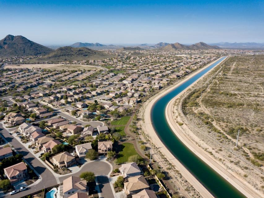
Valley cities have spent years preparing for Colorado River shortages and say they are prepared to keep water flowing even under major federal cutbacks. Photo credit: Ted Wood/The Water Desk

Click the link to read the article on the KJZZ website (Alex Hager):

August 4, 2026

Colorado River shortages are no surprise. Climate change and drought have been steadily cutting into water supplies for about 26 years. Various plans to rein in demand have emerged throughout that time, and new cutbacks have been in the works for more than a year. The amount of water that each Valley city gets from the Colorado River varies significantly from city to city, but the majority receive at least some. Some cities are more prepared than others to weather today’s drier conditions, but most have at least some plan to deal with new Colorado River reductions. The Interior Department set the table for new cuts on Friday [July 31, 2026], laying out the framework of a plan that would allow the federal government to cut the Colorado River supply for Arizona, California and Nevada by up to 40%…A second announcement, which may come in the next few days, will deliver specifics about the size of cuts to the Phoenix area in 2027 and 2028.

Regardless of their scale, city leaders say they will be able to keep taps running.Like any good investor, most utility managers have focused on diversifying their portfolios. Essentially, the more different sources of water that flow to a city, the more it can tolerate cuts to one of those sources. In the Valley, that primarily means getting water from underground aquifers and the Salt River. Underground stores of water, pulled up by a system of wells, are carefully managed under state law and can give cities a backup in times of shortage on the surface. In some cases, water agencies have been taking excess water from the Colorado River for years and adding it to the underground stash, with the idea that it could be retrieved in times like these…In July, the Arizona Water Banking Authority announced that it will use its stored waterto make utilities whole in the event of cutbacks to their supplies from the Colorado River…Older, larger cities also tend to have more money for the kind of expensive engineering that can help diversify a water portfolio. For example, Phoenix is building a massive, high-tech water treatment plant that can safely recycle sewage back into purified drinking water. Major cities around the West are betting big on the technology to help withstand drought and climate change in the long term. Phoenix aims to send water from the $350 million facility into city pipes in early 2029. Cities that use water from the Salt River system are contributing to a multibillion-dollar expansion of Bartlett Dam, which holds back Bartlett Lake. In recent years, after particularly snowy winters, the river has provided more water than the reservoir can hold. A larger dam, cities say, would help them capture, store and use more water from the Salt River system in the future. For cities that lack diverse water portfolios and the kind of money needed for massive engineering projects, there’s a way for them to benefit from the cities that do. In April, as Colorado River cuts were becoming imminent, the city of Phoenix announced a new water transfer program called the “Secure Water Arizona Program”, or SWAP. Details are still emerging about how it would work, but it promises to connect cities that have water to cities that need water…Other water transfers, both in Arizona and across state lines, may be a big part of the long-term plan for cities and towns in the Valley. For example, farms may find it lucrative to sell some of their supplies to fast-growing cities in the metro that are willing to pay top dollar. Native American tribes, which often hold large, powerful legal rights to access the Colorado River, may also be willing to sell. A $5 billion settlement deal is currently in the works to give three Arizona tribes more access to their Colorado River water. If it passes, they could also gain the ability to lease their water to cities far from their reservations. Desalination, a high-tech process that can turn salty ocean water into pure, drinkable fresh water, has long been a tempting proposition for water-short cities. High costs and major logistical challenges mean that Arizona is unlikely to build its own desalination plant anytime soon, but a transfer program could allow it to benefit from an already-operational desalination facility. The Central Arizona Project and a handful of other water agencies around the region are exploring a deal to exchange water rights with a desalination facility in Carlsbad, California.

Arizona Rivers Map via Geology.com.