Wildfire mitigation was front and center yesterday. Click here for my BlueSky feed. Click the link for the conference hash tag feed (click the “Latest” tab).

Wildfire mitigation was front and center yesterday. Click here for my BlueSky feed. Click the link for the conference hash tag feed (click the “Latest” tab).
Click on a thumbnail graphic to view a gallery of drought data from the US Drought Monitor website.
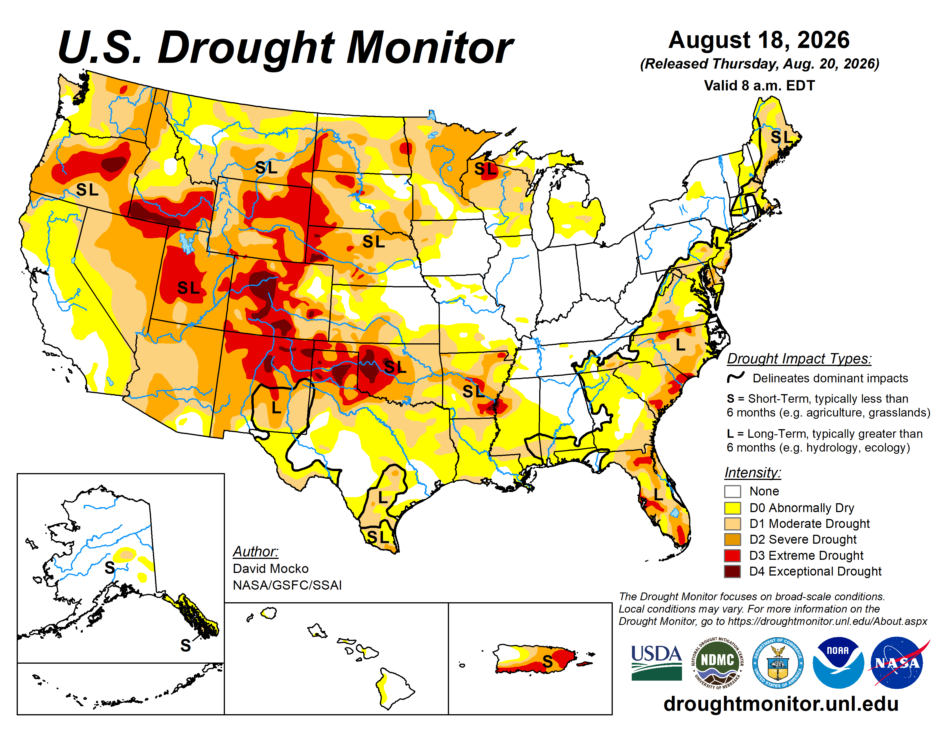
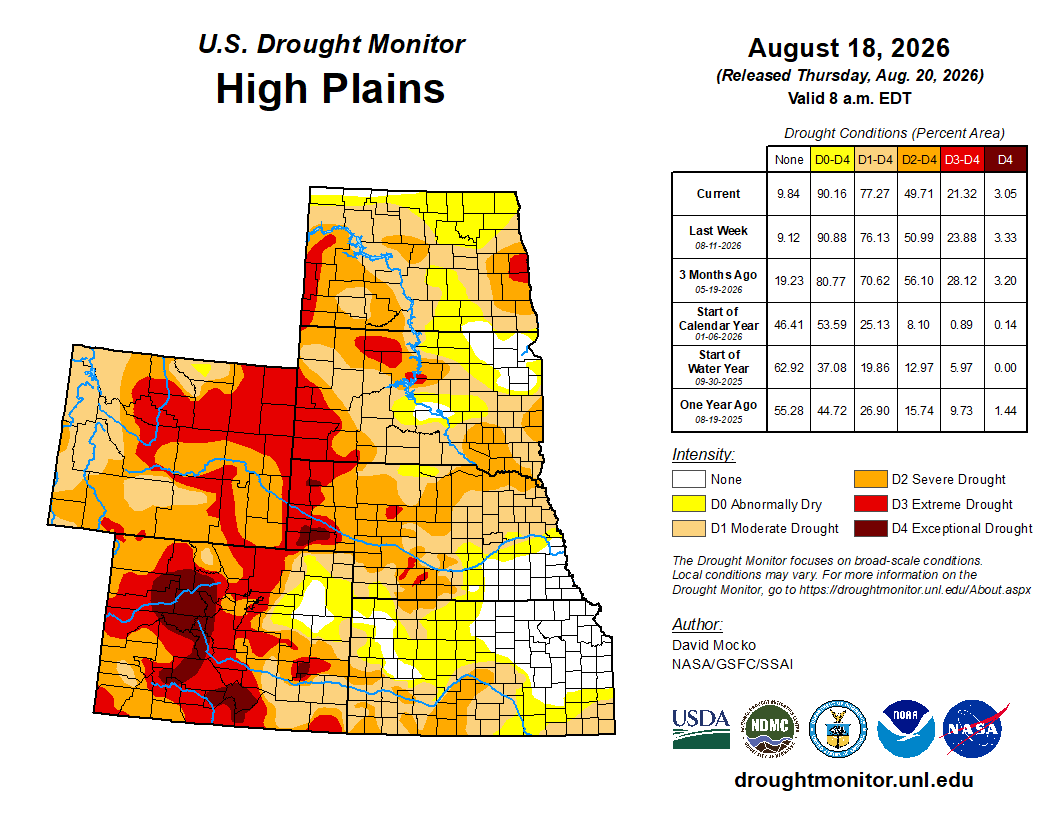
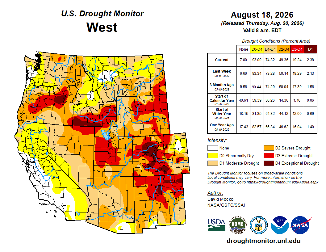
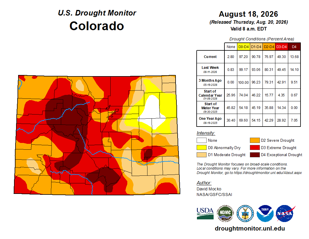
Click the link to go to the US Drought Monitor website. Here’s an excerpt:
This Week’s Drought Summary
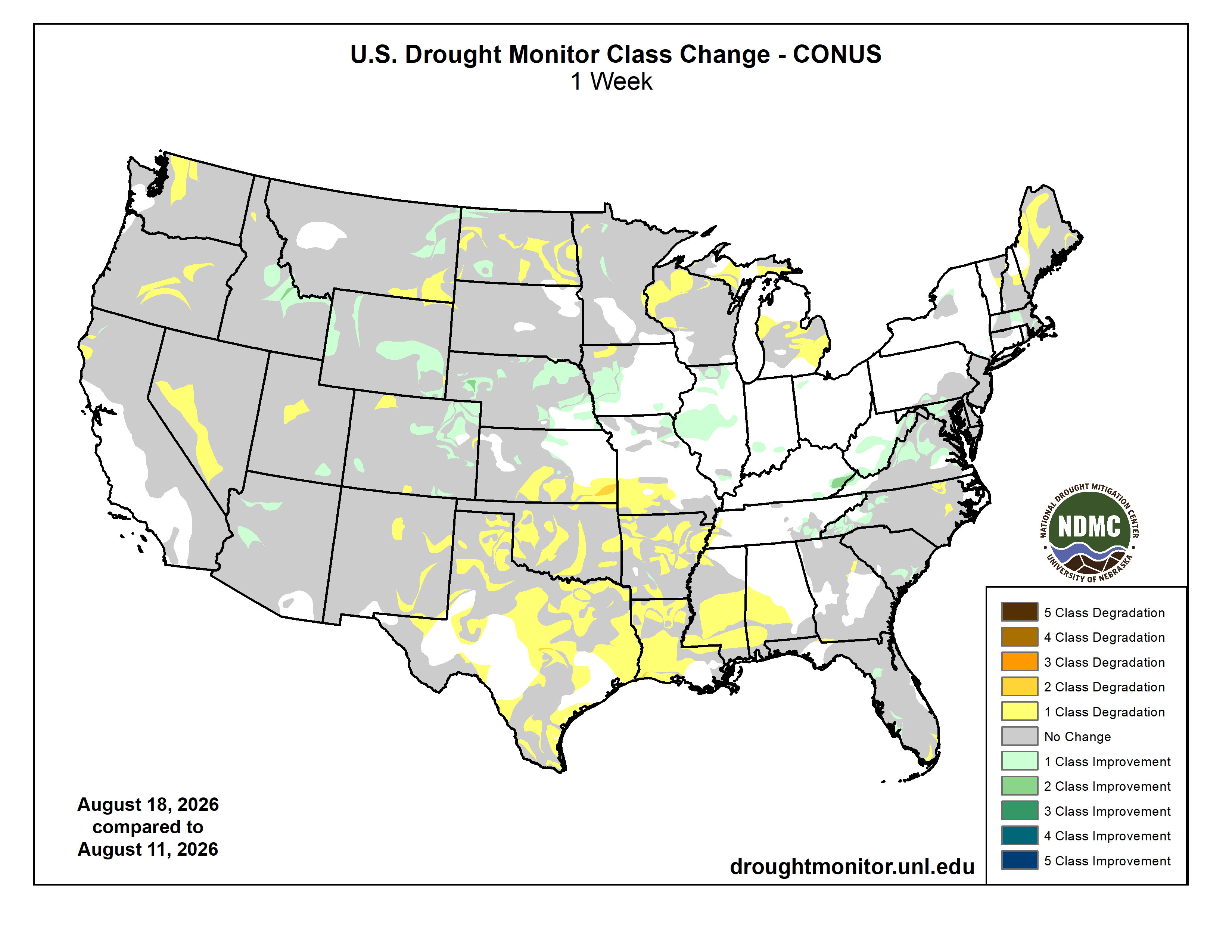
The area with the highest rainfall amounts this past week was primarily a wide band from Nebraska east to Iowa, Illinois, Indiana, Ohio, and West Virginia. Totals over 5 inches were observed in central Illinois and Indiana, with some areas of east Indiana receiving over a foot of rain in the past week. These storms were tracking to the east on the north-side of a high pressure over the southern U.S. The northern Great Plains states also received 1 to 3 inches over wide areas, as did southeast Wyoming, eastern Colorado, and northwest Kansas. In the Southwest, monsoonal flow continued with scattered storms, providing rainfall amounts generally between 0.5 and 1.5 inches. The eastern seaboard from Maine to Florida received scattered but moderate rainfall. The high pressure over the southern U.S. suppressed precipitation over the southern Great Plains and lower Mississippi valley. There was also very limited precipitation in the west coastal states as well as in Michigan and most of Wisconsin.
Temperatures were particularly above normal in the southern Great Plains and lower Mississippi valley, with the warmest above normal area over Oklahoma. The west as well as the southeast were also a few degrees above normal. Rain and storms in the central states from Wyoming to Ohio kept temperatures in this region slightly below average. The northern Great Plains had the coldest below normal temperatures…
High Plains
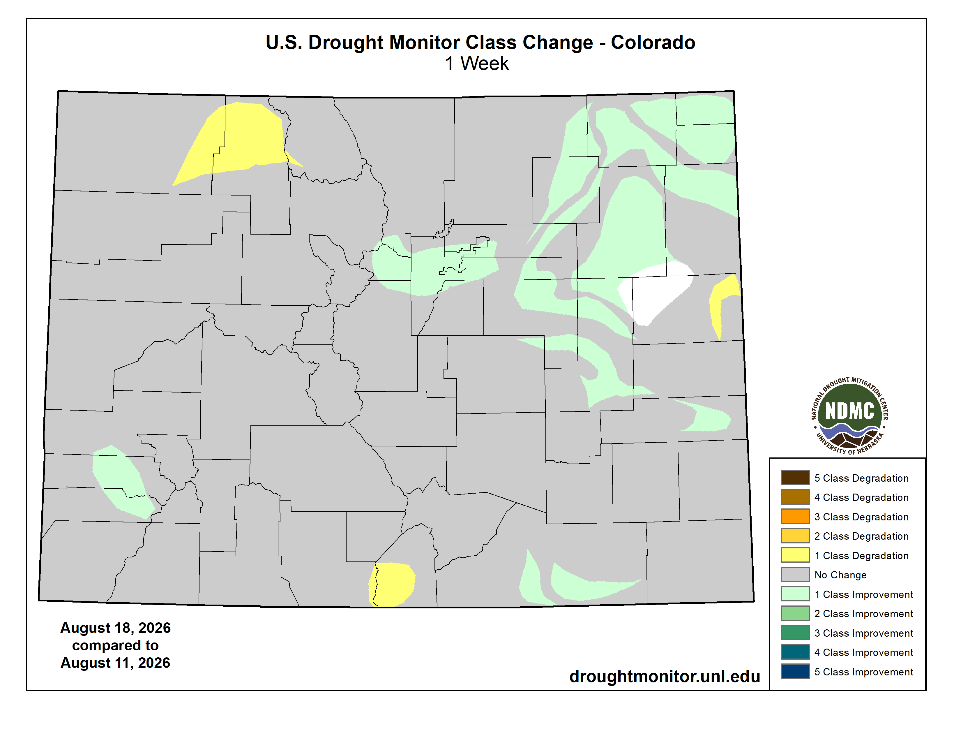
Southern Kansas had some drought degradations from the flash drought warm and dry conditions over the past week. However, eastern Colorado and Wyoming east through Nebraska and northern Kansas received welcome rainfall resulting in drought improvements in these areas. South Dakota was mostly status quo from the past week. North Dakota was mostly dry leading to degradation in drought. Two areas in the southwest and northwest of North Dakota received some rainfall and drought improvement. Extreme drought continues to be in place over western South Dakota and western Nebraska, extending into much of Wyoming and central/western Colorado. Exceptional drought locations are noted in western Nebraska and parts of Colorado…
West
The western states of California, Oregon, Washington, Nevada, and northern Utah generally received little rainfall. There were small to moderate areas in each of these locations with drought degradations. Southern Utah and Arizona experienced some monsoonal rainfall leading to small areas of drought improvement. Eastern New Mexico was warm and dry and had areas of drought degradation. Areas near the Idaho/Montana border as well as northeastern Montana received the most rainfall. Southeastern Montana received little rainfall resulting in a corresponding area of drought degradation. There are areas of extreme drought in Utah, southern Idaho, and in Oregon, with exceptional drought in northeastern Oregon and far southern Idaho…
South
Dryness and drought continued over this region for the past week. All states saw declining drought conditions. The high pressure over the South resulted in anomalously warm temperatures and almost no precipitation. Flash drought conditions had led to dry ponds and creeks and poor to very poor crop conditions in Texas, Louisiana, Arkansas, and Oklahoma. Drought also was degraded over much of southern Mississippi. The only area with drought improvement was eastern Tennessee, where there was significant rainfall. Extreme to exceptional drought conditions continue in western Oklahoma and the Texas Panhandle, as well as southeastern Arkansas…
Looking Ahead
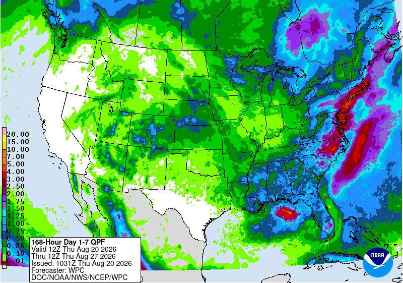
Over the next five days leading up to next Tuesday, above-normal rainfall is possible east of the I-95 corridor along the Atlantic coast. Eastern Indiana, Ohio, and Pennsylvania could also be wet, as well as northern Minnesota and Wisconsin. The area where the Ohio River and Mississippi River meet is also forecast to receive above-normal rainfall. The Southeast should above-normal rainfall in many locations. The South should continue to have below-normal rainfall, with the Southwestern states having moderate monsoonal rains. The West Coast states are forecast to have little rainfall in the next five days.
The 6- to 10-day outlook (August 25-29, 2026) favors above-normal precipitation across the northern half of the Eastern Seaboard from South Carolina to the eastern Great Lakes region and into New England. Surplus precipitation is also favored throughout Hawaii and over most of mainland Alaska, except for the southern coast, southeast peninsula, and the Aleutian Islands. Below-normal rainfall is favored over much of Texas. Temperatures are likely to be well above-normal over much of the continental U.S. other than the far west coast and the eastern Great Lake to Mid-Atlantic. Hawaii is also favored to have above-normal warmth. Alaska is likely to be below-normal in the northwest part of the state and above-normal in the southeast part.

Click the link to read the article on the Summit Daily website (Allison Moore). Here’s an excerpt:
August 17, 2026
Mounting concerns about a lack of surface water prompts Breckenridge Town Council to examine whether portions of the river should be lined
A stretch of the Blue River through downtown Breckenridge appears to have dried up. Residents and town council members have taken notice. James Phelps, Breckenridge’s public works director, said water levels between Skelly Pond near Ollie’s Pub & Grub and the covered bridge near Ski Hill Road have neared historic lows in recent weeks. Bouts of rain have provided only temporary relief. While that stretch of river looks completely dry, Phelps said the water has simply seeped below the rocks into the soil..
At a Breckenridge Town Council work session Tuesday, Aug. 11, council member Dick Carleton requested public works staff lead a longer discussion examining whether the section of river starting at Skelly Pond could be lined to keep more water above ground. Carleton said a group of “informed citizens” approached him with concerns over the lack of water flowing through town…Phelps plans to return to council Tuesday, Aug. 25, with information about what it would take to install a continuous liner through that stretch of river and to gauge the council’s interest in pursuing a design.
The river’s current state, like nearly all other bodies of water across the West, is closely tied to unprecedented drought conditions. Phelps said flows between the dredge pond all the way to Ski Hill Road have approached the lowest levels recorded during 42 years of recorded monitoring. The median flow for this time of year typically remains around 32 cubic feet per second, according to Phelps. In the last two weeks, flows have ranged from as low as 12 cfs to 22 cfs. Rain on Wednesday, Aug. 12, temporarily pushed the flow to about 22 cfs, but by the next day it had already fallen below 16 cfs.


Click the link to read the article on the Circle of Blue website (Brett Walton):
The Rundown
- Army Corps approves a permit for the Line 5 oil pipeline tunnel just as a state permit is invalidated.
- NOAA finds that July was the warmest month in the country’s 132-year historical record.
- U.S. Fish and Wildlife Service takes comments on draining farmland near protected prairie wetlands.
- Two Senate Democrats introduce water system cybersecurity bill.
- USGS reports on long-term changes in U.S. groundwater and surface water.
And lastly, the two big Colorado River reservoirs drop to all-time lows as the federal government prepares a new two-year operating plan.
“What can we do if the administration isn’t willing to allow us to use the [Glen Canyon Dam] bypass tubes for high-flow experiments, if that’s going to be off the table, at least for a while?” – Wayne Pullan, Upper Colorado regional director at the Bureau of Reclamation, discussing Trump administration constraints on using Glen Canyon Dam to assist threatened fish in the Grand Canyon and rebuild eroded beaches along that stretch of the Colorado River. Earlier this month, Reclamation decided against a short-term release of cold water from deeper in Lake Powell to disrupt non-native fish spawning because the release would have reduced hydropower generation. “We’re in a pinch point,” Pullan added. “A real pinch point.”
News Briefs
Line 5 Decision
The Army Corps of Engineers approved a permit for Enbridge to build a tunnel beneath the Straits of Mackinac, a waterway that connects Lake Michigan to Lake Huron. The tunnel would house a new Line 5 oil pipeline.The federal agency’s decision is not the final word. State permits for the tunnel are being litigated and reversed. On July 31, the Michigan Supreme Court invalidated a state Public Service Commission approval because the commission did not properly assess project impacts or need.
Cybersecurity Bill
Some two weeks after Iranian hackers allegedly targeted U.S. water utilities, two Senate Democrats introduced a bill to bolster water system cybersecurity.The Water Cyber Shield Act focuses on risk reduction. It requires water systems to assess their cybersecurity risks, develop a response plan, and submit them for state approval. The submitted information is exempt from FOIA.
The bill also requires the EPA to establish baseline cybersecurity standards that impose more burdens on higher risk water systems. It authorizes $300 million annually over five years to help drinking water systems identify and fix vulnerabilities, as well as $300 million annually for wastewater systems.
Studies and Reports
Hottest Month
July broke all the all-time heat record in the lower 48 states.According to NOAA data, it was the hottest single month since record-keeping began at the end of the Gilded Age, in 1895.
The average temperature for those 31 days was 76.9 F, which was 3.3 F above the 20th century average. It was especially warm in the Intermountain West, where states are also observing record-low river flows. [ed.emphasis mine]
Water Trends
The West and the High Plains are drying while the Upper Midwest and Northeast are getting wetter.That is the broad pattern identified in a U.S. Geological Survey evaluation of large-scale groundwater and surface water changes between 1980 and 2020.
On the Radar
Colorado River’s Shrinking Reservoirs
Both Lake Mead and Lake Powell now sit at their lowest levels since the manmade reservoirs were first filled.The record-breaking plunge underscores the precarity of water supplies in the Colorado River basin. Because this year’s mountain snowpack has already melted, the reservoirs will likely set new lows through at least next April.
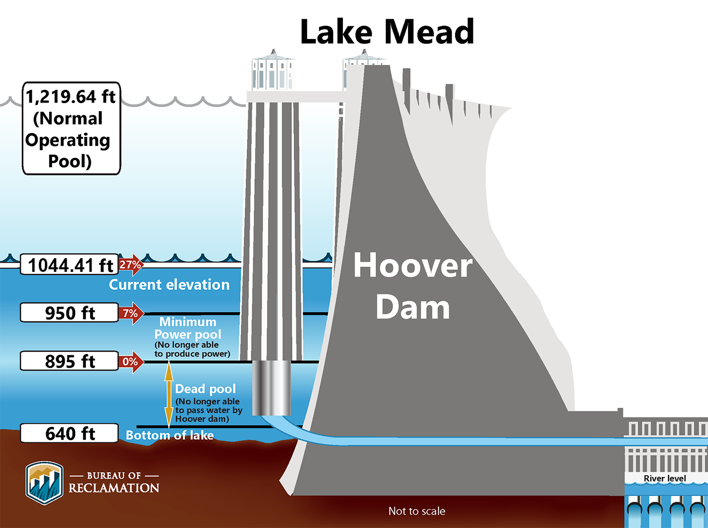
Lake Mead is at 1,039 feet, four feet above the level at which hydropower generating capacity at Hoover Dam will drop by 70 percent.
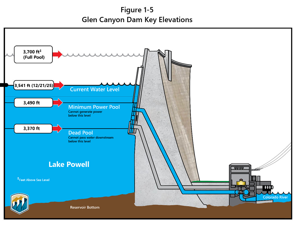
Lake Powell rests at 3,519 feet. The Bureau of Reclamation is attempting to keep the reservoir above 3,500 feet to protect Glen Canyon Dam’s water supply and power-generating infrastructure.
In context: Glen Canyon Dam Faces Its Existential Moment
Draining, or Not Draining, Prairie Wetlands
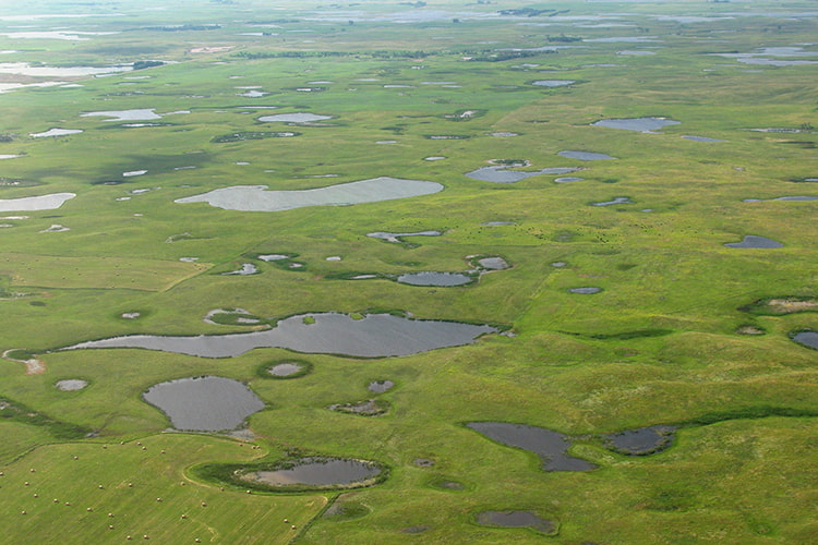
The U.S. Fish and Wildlife Service took comments on the process for draining waterlogged lands for farming in an important duck habitat in the northern plains where the government holds wetlands easements.Formed by retreating glaciers, prairie potholes are shallow ponds in Iowa, Minnesota, Montana, North Dakota, and South Dakota that sustain most of North America’s waterfowl. To protect the habitat, the FWS began buying easements from farmers in 1959. Those easements prohibit draining the wetlands.
To grow crops on sodden land, farmers install drain tile – perforated pipes placed underground. Farmers whose land contains an easement can request the FWS calculate a distance beyond the wetlands where drain tile can be installed.
The agency wants to know how it should make those calculations.