President Trump attacks the Roadless Rule, again, Plus: Hoback Report on the Traffic Apocalypse — Jonathan P. Thompson (LandDesk.org)

Click the link to read the article on The Land Desk website (Jonathan P. Thompson):

August 21, 2026

🌵 Public Lands 🌲

Sometimes it feels like the deeper the Trump administration sinks into various quagmires of its own making, the more it lashes out at politically popular protections for public lands. Each passing day brings a new assault on the environment, the climate, and, well, humanity.

This time, the U.S. Department of Agriculture has moved (again) to rescind the Roadless Rule, which protects some 45 million acres of U.S. Forest Service land from new roadbuilding and logging. Agriculture Secretary Brooke Rollins predictably and baselessly claimed that the rule has hampered forest management and fire-fighting capabilities. This is untrue.

When the Bill Clinton administration implemented the Roadless Rule in 2001, it culminated a multi-decade effort to identify and set aside forest lands that hadn’t been disturbed by roads for possible designation as wilderness. At the time, management of inventoried roadless areas was carried out by individual Forest Service offices. The Roadless Rule put a nationwide prohibition on timber harvesting, road construction, and road reconstruction in inventoried roadless areas, with a number of exceptions. The intent was not only to conserve these relatively undisturbed areas, but also to save money: By 2001, the Forest Service’s existing road network was over 386,000 miles long, with an estimated $8.4 billion in deferred maintenance and reconstruction. Building more roads would just exacerbate that deficit.

While inventoried roadless areas have many of the same characteristics as wilderness areas, the Roadless Rule stops far short of offering wilderness-level protections, and expressly allows for motorized uses of existing roads, off-highway motorized use in specified areas, livestock grazing, and energy and mineral development.

So it’s hard to take Rollins seriously when she says the rule is hampering access for fire prevention and fighting efforts. In fact, the rule clearly allows for road-building to fight fires. It also allows for cutting, removing, and selling ā€œgenerally small diameter timberā€ for various reasons, including ā€œreducing the likelihood of uncharacteristic wildfire.ā€

In a Senate hearing this spring concerning Sen. Mike Lee’s (MAGA-UT) amendment aiming to repeal the Roadless rule, Sen. Alex Padilla, D-California, pointed out that 240,000 acres of inventoried roadless areas in his state alone had been treated for wildfire hazard mitigation treatment, showing the dubiousness of Lee’s (and now Rollins’) claims. And the Trump administration, for better or worse, has lagged on forest thinning: A Center for Western Priorities analysis found the Forest Service treated 35% less acreage in 2025 than it did under Biden in 2024. That suggests that vegetation management is being stifled not by regulations, but by a lack of resources — the Trump administration has slashed Forest Service staffing and budgets considerably since taking office.

In fact, the evidence suggests that the Roadless Rule has actually helped deter wildfires. A 2007 Pacific Biodiversity Institute study found that 88% of the nation’s wildfires are sparked by humans, and 95% of human-ignited blazes occur within a half-mile from a road. Roads act like syringes, injecting humanity — along with their errant cigarette butts, untended campfires or grills, sparks from machinery or hot catalytic converters — further into the backcountry than they would go by trail.

The Roadless Rule originally applied to almost 60 million acres, but in the years following its implementation, it was bandied about by presidential administrations and the courts. In 2005, the George W. Bush White House revoked the rule and replaced it with the alternate roadless rule, which allowed states to petition the Forest Service to create their own standards; Colorado and Idaho chose to do so. When the Tenth Circuit court later reinstated the 2001 rule, the 2005 rule was nullified, but Idaho and Colorado’s rules remained in effect. As a result the administration’s proposed repeal would not affect Colorado and Idaho’s plans.

The rule and its moderate protections for habitat, wildlife, forests, and watersheds have proven deeply popular across a wide demographic swath of the public. Last June, Rollins moved to repeal the Roadless Rule for the first time, resulting in intense backlash not only from environmentalists, but also from the more conservative-leaning hook and bullet crowd and general public, which barraged the department with comments supporting the rule. It’s worth noting that even Project 2025, the ultra-right-wing ā€œblueprintā€ for the Trump administration, called for repealing only the portion of the Roadless Rule that pertained to Alaska’s Tongass National Forest. This spring, when Lee tacked a Roadless Rule-repealing amendment onto bipartisan wildfire legislation, he annihilated the cross-aisle support for the larger bill, effectively ruining its chances of passing.

Now the public has a chance to weigh in once again. The USDA is accepting comments until Sept. 21,Ā so go here and say your piece.

ā›ˆļø Wacky Weather Watchāš”ļø

The summer of nightmare heat continues as yet another heat dome settles over parts of the West. Parts of southern California, Las Vegas, Phoenix, and most areas in-between are under heat watches or extreme heat warnings for the next several days. There is also a chance of thunderstorms, which may bring a bit of relief, but if the summer so far is any indication, they’re just as likely to bring catastrophic flash flooding, damaging winds, fire-starting lightning, and huge dust storms, a.k.a. haboobs.

šŸ›¢ļø Hydrocarbon Hoedown šŸ“ˆ

I know that many of you have been hating on data centers lately, especially the ones used to process all that AI slop so that billionaires can become trillionaires (through some process that defies all logic). But please, I beg you, save some of your disdain for the oil and gas companies, too! After all, they are using the data center energy-use scare to justify drilling for natural gas to power the damned things. Not only that, but every day that our president screws up negotiations to end his war on Iran is another day that the Strait of Hormuz remains closed to oil tankers, another day of rising oil prices, and another day of record-high profits for petro-corporations, their executives, and their shareholders. 

For example: ExxonMobil reported adjusted earnings of $23.5 billion for the first half of 2026; Chevron’s adjusted earnings were $14.7 billion; Valero raked in a $5.4 billionprofit … you get the picture. 

šŸ—ŗļø Messing with Maps šŸ§­

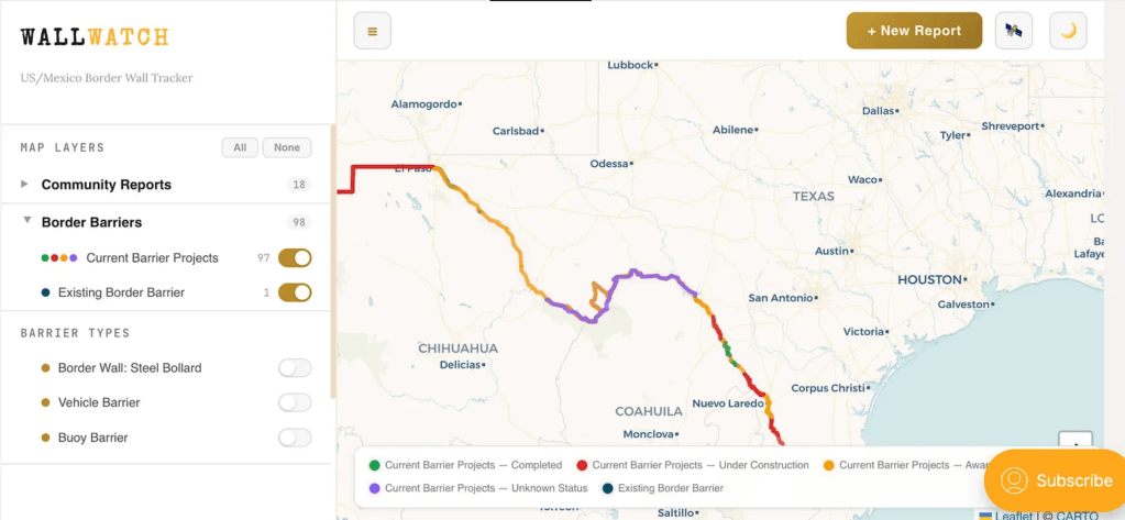
If you want to know what’s happening on the U.S.-Mexico border, you go to the Border Chronicle. And now, if you want to know what’s happening with Trump’s border wall, which is just a monumental piece of environmental disaster, you can go to the Border Chronicle’s new Wall Watch, the publication’s community-reported interactive map tracking construction of the barrier.

Say you want to know what sort of wall is being built in the Big Bend region? Or what sort of structure already exists near Lochiel, Arizona, where border wall contractors have destroyed old-growth cottonwood trees and are threatening the remainder of the grove? You can toggle the map to the satellite view, zoom in on the place of interest, and click on the border and get a pop-up informing you of what work is taking place, who the contractor is, and the expected cost.
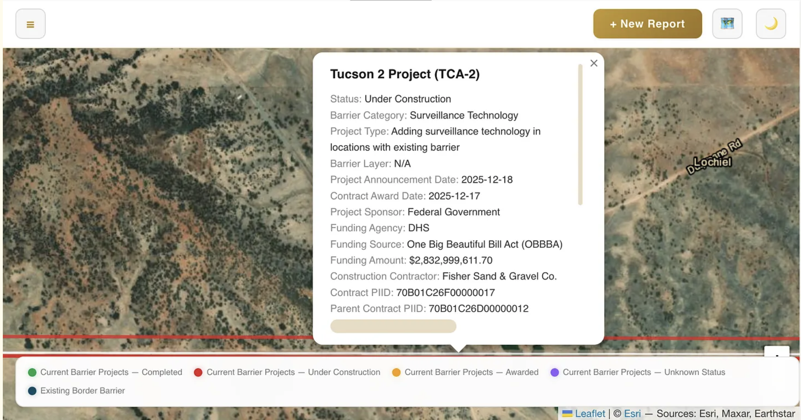
Screenshot from the Border Chronicle’s Wall Watch.

šŸ“ Hoback Report

A guest post by Bob Frodeman


Could the West be the place where America finally gives up its belief in endless growth? Probably not, but you can imagine different triggers. For instance, drought, a shrinking snowpack, and a parched Colorado River could halt growth in Phoenix. Or overwhelming numbers of tourists in Yellowstone or Arches National Park could force the establishment of timed entry (which Arches had, until the Trump Administration decreed that this was oppressing the right of people to sit in traffic). Or climate change-driven wildfires threatening entire cities (see Spokane) could put a crimp in sprawl.

But in my neck of the woods traffic may be the trigger.

Traffic is getting absurd in Jackson. The chaos used to be limited to the summer months; now it’s pretty much year-round. Climate change has extended the hiking season on both ends: this May a new record was set for visitation in Grand Teton National Park. And while the valley floor was denuded of snow last winter (a brown Christmas – in Jackson?!), the snow fell higher up, giving us some of the best skiing in the West during a generally horrific snow year.

Policy, history, and geography all contribute to the situation. First, it’s just plain hard to get here: there are only three roads into the valley. The spectacular mountains and forests mean that more than 97% of Teton County is publicly owned – Teton and Yellowstone National Parks, Bridger-Teton National Forest, and the National Elk Refuge. The Elk Refuge offers a striking visual: created in 1912, when Jackson had a population of a few hundred, the Refuge now hems town in on the north side, preserving land that would otherwise be jammed with hundreds of homes. Another 1% of the land is covered by conservation easements.

Caught between public land, various bumps and ridges, and the Snake River, there’s only one artery in town, called Highway 89 when it runs north-south, and Broadway when it turns east-west. Pressed up against Saddle Butte, Broadway already is five lanes and would be hell to expand. Highway 22, a two-lane spur that runs up and over Teton Pass that WYDOT wants to expand to five lanes, is already a traffic nightmare morning and night. And all the other roads in town are suburban streets lined with homes.

Nonetheless, the Town of Jackson currently has 825,000 square feet of additional development in the works. This includes the 245,000 (down from the original 400,000) square-foot Mogul development, a humungous hotel and condo complex planned for the northern entrance to Jackson (traffic already backs up a mile or two every afternoon on that road coming into town). The Jackson Town Council has approved the sketch plan for the complex. The other 600,000 square feet are scattered across the downtown area. On top of this, on the southern edge of town – on what will essentially become an extension of town – a new subdivision called Northern South Park has begun construction. Situated on ranch land, Teton County has approved a neighborhood of 1,437 homes, which would add 23% to the existing housing stock of Jackson.

What’s bizarre is the lack of self-consciousness about what’s happening. A few weeks ago I wrote a town council member asking for the list of ongoing projects. There isn’t one. I generated the 825,000 number by calling up the town clerk and asking her to go through the various applications. We added it up together.

Given all this, plus the 4 million annual tourists, it’s hard to see how Jackson will avoid utter and complete gridlock. But wait—it gets better, by which I mean worse. Because land is so scarce in Teton County, and home prices so high (median price $2.5 million, eight times the Wyoming average), workers drive in from Star Valley (30 miles to the south) and Teton Valley, Idaho (30 miles to the west). Both areas are primed for more growth: the population of Teton Valley doubled from 2000 to 2020 (to 10,000) and is projected to be the fastest growing part of Idaho. And this is to say nothing about the dangers of traveling Teton Pass – there was a landslide there two summer ago that diverted traffic for three weeks, and this summer a runaway truck killed two people.

Most of these people, as well as the commuters from Star Valley, come to Jackson for work and play. It adds up to a traffic apocalypse. Alas, Jackson and Teton County has no control over these outlying areas. The obvious move is to create a regional authority to work on the problem. But no such authority exists, and the political culture of these areas is quite different from Jackson, which makes conversations hard.

In Jackson you hear a lot of talk about managing growth. What you don’t hear is talk about the necessity of stopping growth. But this is the conversation that Jackson needs to have – as well as many other places across the West that are bumping up against limits.

#ColoradoRiver crisis threatens crops, not #Wyoming’s dam plans, experts say: Feds’ new plan doesn’t resolve crop-threatening water shortage and likely will end up in court, two professors reckon — Angus M. Thuermer Jr. (WyoFile.com) #COriver #aridification

The Bureau of Reclamation’s 10-year plan for managing Colorado River flows seeks to preserve enough water behind the Hoover Dam to sustain electricity generation. (Angus M. Thuermer Jr./WyoFile)

Click the link to read the article on the WyoFile website (Angus M. Thuermer Jr.):

August 18, 2026

A federal drought plan for the Colorado River and its tributaries in Wyoming shouldn’t stop Wyoming from building a new dam and reservoir in Carbon County, two Western water experts say.

The Bureau of Reclamation plan for the sweeping basin focuses on maintaining enough water in Lake Powell and Lake Mead to generate electricity and prevent degradation of critical infrastructure, professors from Utah and Arizona said last week.

The 10-year framework to manage water storage and releases in the complex seven-state, two-nation system seeks to balance predictability and flexibility in two-year increments. It also acknowledges that the government has little to no authority over water use in headwater states Wyoming, Utah, Colorado and New Mexico, said Sarah Porter, the director of the Kyl Center for Water Policy at Arizona State University’s Morrison Institute.

ā€œOne way of reading the final environmental impact statement,ā€ Porter said, ā€œis the Bureau’s determination that it doesn’t really have any authority to limit water use in the headwaters.ā€ [ed. emphasis mine]

A controversial dam proposed on the West Fork of Battle Creek, which flows into the Little Snake River, above, and the Colorado River could still be built despite a drought that prevents Lake Powell and Lake Mead from filling. (EcoFlight)

Drought will likely cause agricultural stress in Arizona, Nevada and California, threatening the supply of winter vegetables and possibly other crops, she said.

ā€œWe probably won’t be eating as many salads,ā€ she said, because Arizona is where winter lettuce is harvested. ā€œIt’s all grown in Yuma.ā€

More important for Wyoming might be that the Bureau of Reclamation’s final environmental impact statement recognizes the independence of headwater, or upper-division, states to essentially use water as they see fit. Efforts to conserve water in the Upper Basin ā€œare not within the scope of this EIS,ā€ the federal document states.

So while farmers downstream may see their traditional supplies cut, Wyoming forges ahead with plans for the 10,000-acre-foot West Fork dam and reservoir in Carbon County where 6,000 acre-feet a year would be poured onto fields for late-season irrigation on ranches.

Energy equation

The Bureau is imposing the plan after the seven states failed to agree on how to share Colorado River flows as drought crimps traditional allotments that were based on too-rosy estimates.

ā€œWe have the lowest reservoir storage we’ve ever seen,ā€ said David Rosenberg, a Utah State University professor and water researcher. ā€œWe have very low inflows.ā€

He and Porter spoke in a Zoom webinar hosted by SciLine, a nonprofit that connects reporters with scientists.

The two called the Bureau of Reclamation plan a decision-making framework for distributing water in the three Lower Basin states — initially for two years.

ā€œIt doesn’t place the basin on a path to stabilizing the system at all,ā€ Porter said. ā€œIt doesn’t resolve conflict at all. It doesn’t achieve the [long-term] things that the basin really needs at this point.ā€ [ed. emphasis mine]

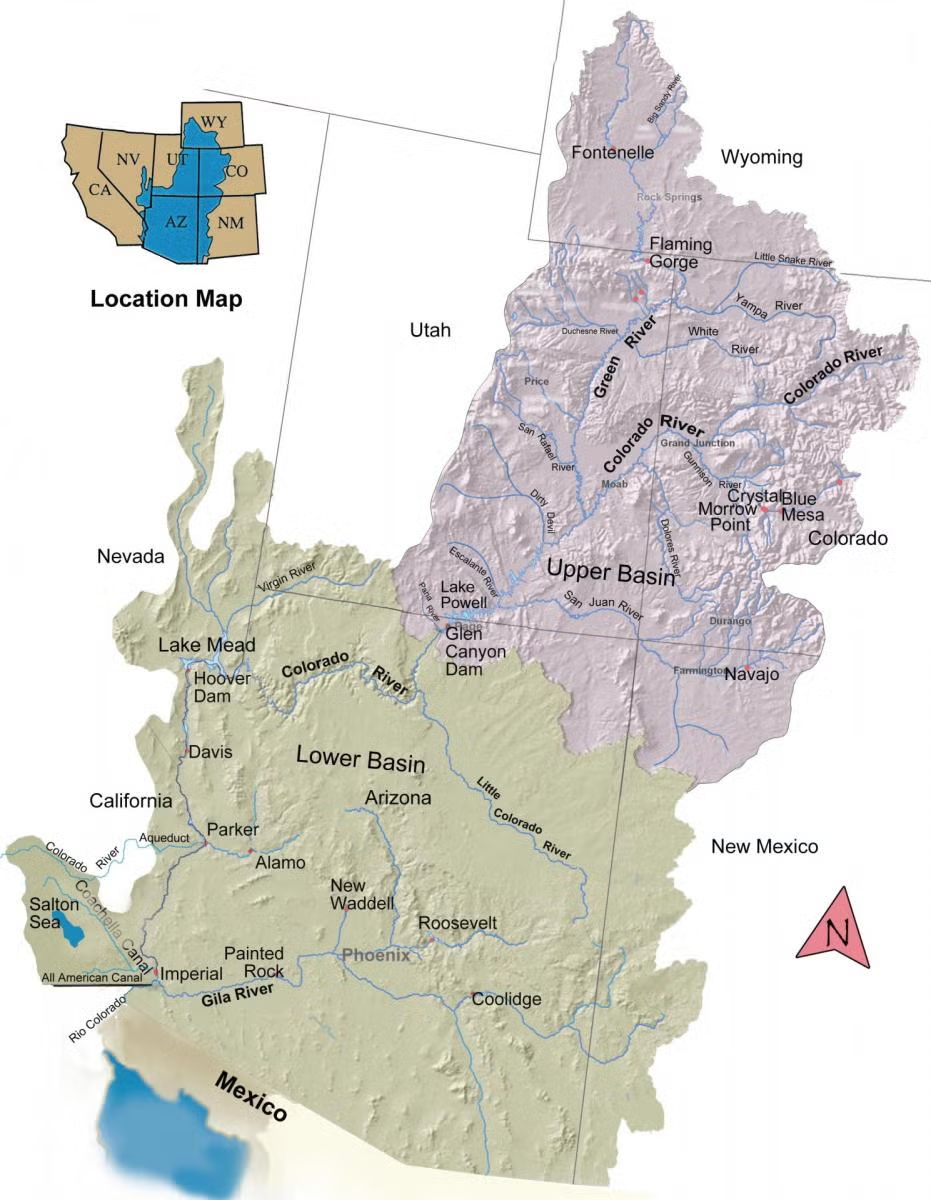
The Colorado River Basin spans seven U.S. states and part of Mexico. Lake Powell, upstream from the Grand Canyon, and Lake Mead, near Las Vegas, are the two principal reservoirs in the Colorado River water-supply system. (Bureau of Reclamation)

But the plan is ā€œa very clear statement,ā€ Rosenberg said, ā€œof how they’re going to protect infrastructure.ā€

That infrastructure includes the two major dams, associated power plants and canals that would become useless, even degraded, if the water levels in Powell and Mead drop below critical levels. With the plan, Rosenberg said, the Bureau states: ā€œWe’re still going to be generating hydropower.ā€

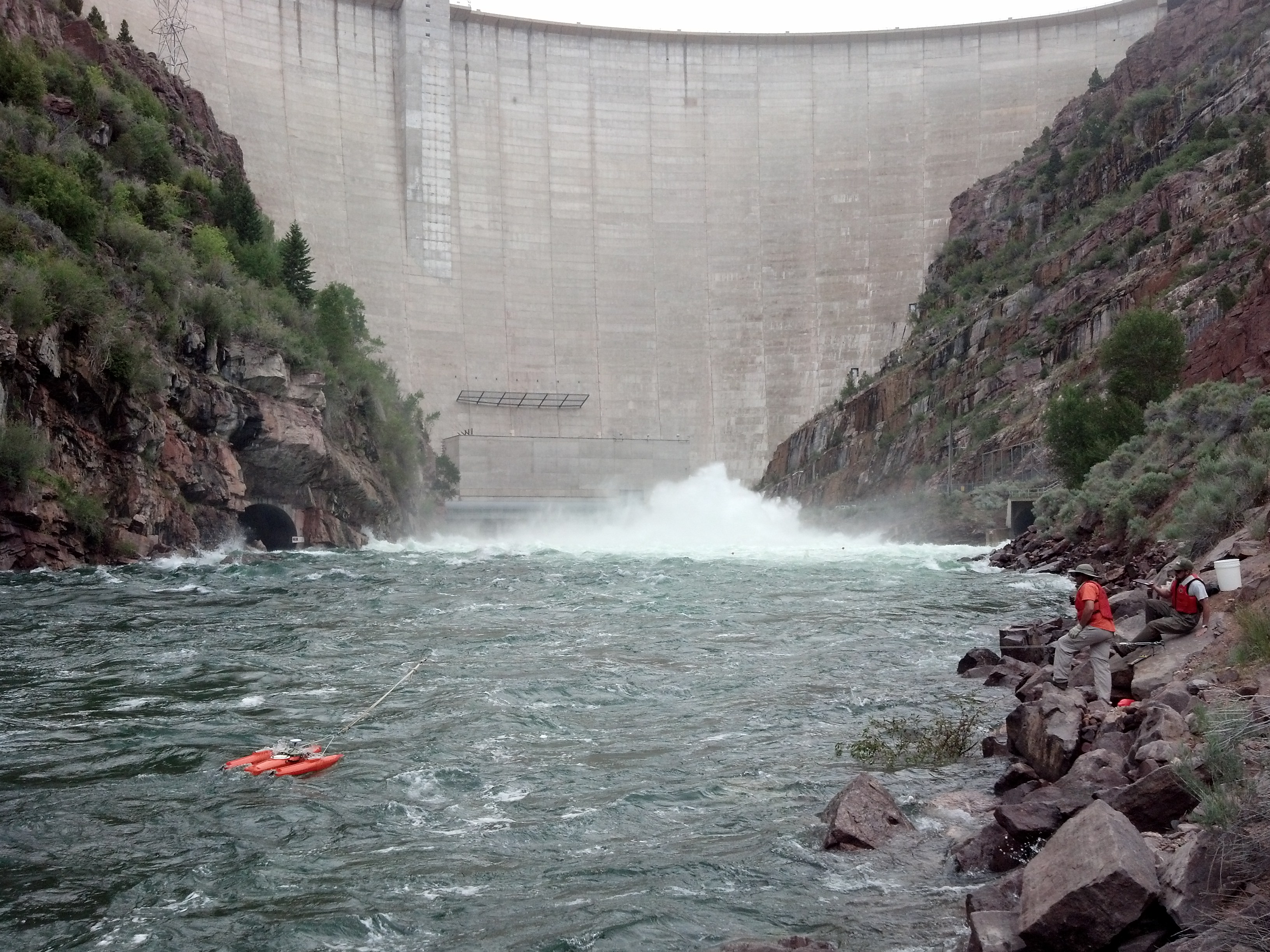
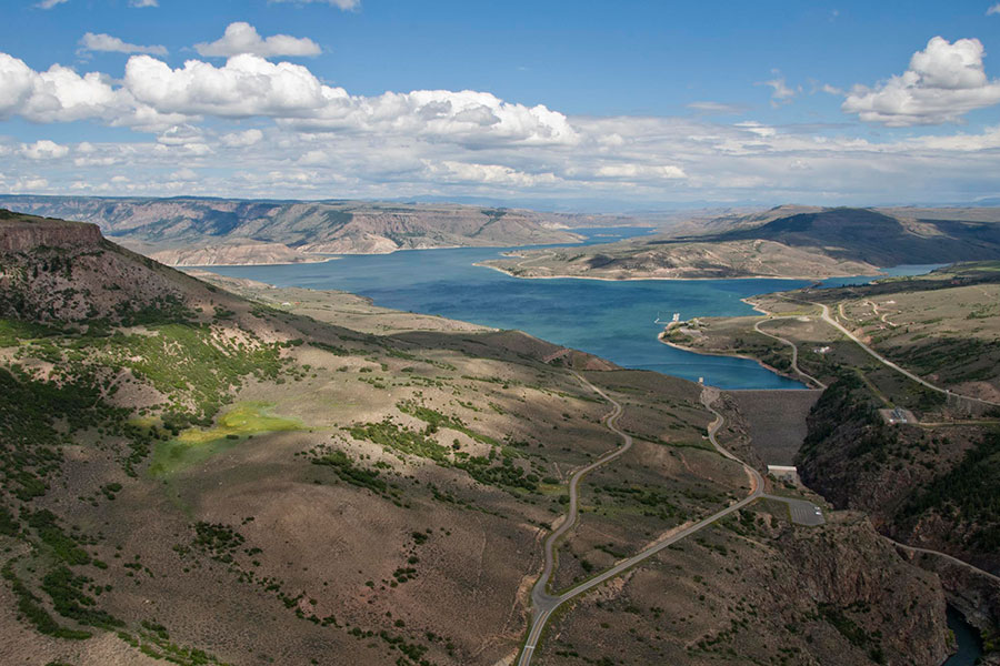
Powell’sĀ Glen CanyonĀ and Mead’sĀ Hoover dams can generate some $443 million of market-price electricity a year when operating fully, according to calculations from the Bureau of Reclamation and theU.S. Energy Information Administration. To keep those two reservoirs flush, the Bureau will release water from Wyoming’s Flaming Gorge Reservoir and from Colorado’s Blue Mesa Reservoir and New Mexico’s and Colorado’s Navajo Reservoir.

Beyond that, the Bureau’s plan targets the three Lower Basin states for reductions, depending on water in the river system and reservoirs.

Headwater states largely rely on stream and river flows determined by spring runoff. The at-risk region in Wyoming includes the Green River and its tributaries and the Little Snake River in Carbon County.

In contrast, the Lower Basin ā€œgets all of its water, Colorado River water, from the reservoirs,ā€ Porter said. It’s a lot more complicated to curtail Upper Basin use ā€œthan simply to not deliver water out of a reservoir,ā€ she said. ā€œAnd that’s a sore point with the Lower Basin.ā€

The two professors predicted a fight. ā€œWe expect they’ll be challenging this administrative process,ā€ Porter said of the lower division states’ reaction to the Bureau’s EIS.

Compact call coming

There’s more on the horizon too.

ā€œI also expect that within the next year and a half, or maybe two years, there will be what we call a compact call,ā€ Porter said, ā€œa demand from the Lower Basin for water that the Lower Basin contends the Upper Basin is obligated to deliver.

ā€œThat challenge will occur in the United States Supreme Court and that could take 10, 20, 30 years.ā€

Under the 1922 Colorado River Compact and associated agreements, the upper division states can’t diminish the flow from Lake Powell below 7.5 million acre-feet annually, calculated on a 10-year rolling average. That’s half what engineers originally calculated the watershed would produce; half belonging to the headwater states, half to the Lower Basin. That estimate is now considered to have been exuberantly optimistic. [ed. emphasis mine]

ā€œWe really need to figure out a way collectively to be reducing demand in the Colorado River by at least 3 million acre-feet out of the 15 million,ā€ Porter said, ā€œand that probably can’t all fall on the Lower Basin.

ā€œThe Lower Basin,ā€ she said, ā€œdidn’t agree to be junior to the Upper Basin.ā€

If Upper Basin states don’t deliver the 7.5 million acre-feet past the Lee Ferry gauging station just below Lake Powell, headwaters curtailment will begin, starting with the most recent, or junior, water-right holders.

Until then, conservation in Wyoming will be voluntary, generally meaning that if an irrigator or other user forgoes their water right, they will need to be paid. In previous trial conservation programs, that has cost $500 an acre foot.

But a compact call by Lower Basin states would lead to curtailment — a mandatory cutting off of Upper Basin water use starting with the most recent, or junior, rights’ holders. Long-established ranches and irrigators hold senior rights while Wyoming municipalities and industries in the Green River Basin are likely among the first to be curtailed.

The proposed dam would be 264 feet high, 700 feet long and made out of concrete. (Major King for WyoFile)

Under the ā€œLaw of the River,ā€ Wyoming has rights — on paper — to 14% of the Upper Basin’s 7.5 million acre-feet annually. That’s about 1 million acre-feet. But the state engineer estimated in 2010 that Wyoming’s rights amount to 847,000 acre-feet a year, according to the state’s 2010 plan for the basin. Wyoming uses 680,076 acre-feet and has rights to another 166,924, the latest plan states.

That makes the 100,000 or so Wyomingites who rely on or use Green River water relatively water rich compared to the 40 million down-streamers who rely on the river for some or all of their agricultural and municipal needs. In essence, 100,000 Wyomingites have rights to almost 1 million acre-feet while 39.9 million down-streamers divvy up 7.5 million acre-feet.

The implications go beyond the scarcity of your garden-variety salad.

ā€œIf there are big reductions in water supplies to those [Lower Basin] areas, there really will be impacts on our food supply nationally, not to mention other impacts,ā€ Porter said.

Phoenix reclaims wastewater through a multi-step filtration process – settling, aeration, disinfection – turning it into clean water for parks, cooling, and natural restoration.

Recycling water

While the prospect of southwestern metropolises crashing headlong into ugly sewerage problems caused by the crisis would seem to loom, don’t put all your money into wag-bags and porta potties yet. The municipalities are figuring out how to cope.

ā€œThose cities are making massive investments in advanced water purification to treat reclaimed water to potable to reduce reliance on annual deliveries of Colorado River water,ā€ Porter said. ā€œThat access to other water supplies or other water management strategies isn’t really available to agricultural water users or, to a great extent, the tribes who are significant rights holders to Colorado River water.

ā€œWe may see impacts to cities really smoothed out and not be very disruptive,ā€ she said. ā€œIf we do have disruptive impacts, they will probably fall on rural areas and tribal communities in the Lower Basin.ā€

Yampa River Basin via Wikimedia.

South Platte River Basin #climate for the week ending August 24, 2026 #SouthPlatteRiver

Below is the Precipitation Accumulation in South Platte graph from the NRCS for August 24, 2026. This morning precipitation is at 75% of the median (no change one week), and 69% of the water year median (up 1% one week). There are 37 days left in the water year.

There is a chance for thunderstorms today and Tuesday, showers are likely Wednesday, with a chance for thunderstorms Thursday, a slight chance for thunderstorms Friday, and a chance for showers and thunderstorms Saturday and Sunday, in the central mountains. There is a chance for thunderstorms today and Tuesday, showers are likely Wednesday and Thursday, with a chance for thunderstorms Friday, Saturday, and Sunday, in the northern mountains. There is a chance for thunderstorms today through Thursday, with a slight chance of showers and thunderstorms Saturday, and a chance for showers and thunderstorms Sunday, down here about 200 miles from Boggsville, where Amache Prowers moved with her husband in 1867. From Wikipedia:

Amache Ochinee Prowers, also known asĀ Walking WomanĀ (c. 1846–1905), was a Native American activist, advocate, cattle rancher, and operator of a store on theĀ Santa Fe Trail. Her father was aĀ CheyenneĀ peace chief who was killed during theĀ Sand Creek massacreĀ on November 29, 1864, after which she became a mediator between Colorado territorial settlers, Mexicans, and Native Americans during the 1860s and 1870s. She was inducted into theĀ Colorado Women’s Hall of FameĀ in 2018…Amache, a full-blooded member of theĀ Southern CheyenneĀ tribe, was born possibly in the summer of 1846 during a forced march of her tribe across the plains of Southeastern Colorado…John Wesley ProwersĀ was a trader who visitedĀ and then employed byĀ William BentĀ at Bent’s Fort.Ā He saw Amache perform a Cheyenne dance around 1860. Later, he askedĀ Chief OchineeĀ if he could marry Amache the following year.Ā They were engaged in a typical Cheyenne courtship, which involved exchanging gifts. In 1861, at the age of 15Ā or 16,Ā she married 25-year-old John Wesley Prowers, a cattleman and trader.Ā After their marriage, they spent a few months inĀ Westport, Missouri, where she learned the traditions of white women.Ā She experienced prejudice, being called “that Indian woman” by John’s brother-in-law, John Hough.Ā Then they lived at Bent’s Fort…John and Amache worked together in their business and personal pursuits and settled along theĀ Santa Fe TrailĀ inĀ Boggsville, ColoradoĀ in 1867. They lived in a 14-room adobe house, which is aĀ Boggsville Historic SiteĀ inĀ Bent County, where they raised nine children…Her father helped negotiate a treaty between the government, Cheyenne, andĀ Arapaho to safely camp along Sand Creek during the winter of 1864–1865.Ā At that time, he had met with the Territorial Governor,Ā John Evans. ColonelĀ John ChivingtonĀ certified that Lone Bear was a man of good character and a “friendly Indian.”Ā Before the attack, the Prowers family, including Amache, were held hostageĀ to prevent them from warning Cheyenne at the Sand Creek winter camp site of the iminent attack…On November 29, 1864, the Cheyenne camp at theĀ Sand CreekĀ was attacked by 600 soldiers of theĀ Colorado Volunteer CavalryĀ and her father, Peace Chief Ochinee (Lone Bear) and 160 other people, most of whom were children and women, were killed.Ā Her mother was able to escape…Amache went later to theĀ CongressĀ with her husband and testified to seek justice for the Cheyenne.Ā She and her two oldest daughters and her mother each receivedĀ reparationsĀ by the United States government in the form of 640 acres of land along theĀ Arkansas River. Amache used her land to expand her family’s cattle ranch…Located on the Santa Fe Trail, she and her husband ran a store,Ā hotel, post office, county office, and schoolĀ where people of Euro-American, Native American, and Latin descent met and exchanged information.Ā Prowers spoke English, Spanish, and the language of her birth, Cheyenne.

Amache Prowers, Cheyenne mediator, late 19th century By Unknown author – Colorado Women’s Hall of Fame, likely taken in the 19th century, but by 1905 when she died, Public Domain, https://commons.wikimedia.org/w/index.php?curid=87606752
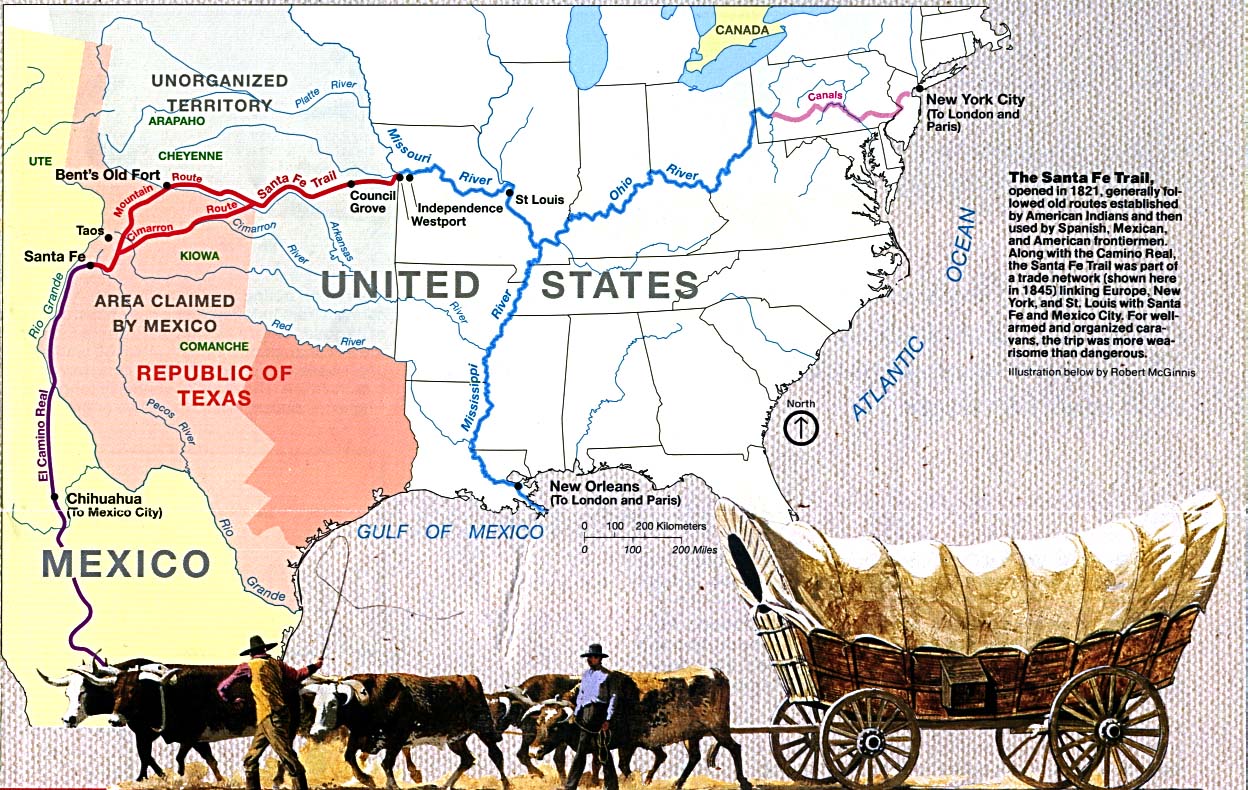
Map of the Santa Fe Trail. By United States National Park Service-Map, Robert McGinnis-illustration – http://www.lib.utexas.edu/maps/national_parks/santa_fe_trail94.jpg, Public Domain, https://commons.wikimedia.org/w/index.php?curid=18223016

Here’s a look at the 7-Day Colorado precipitation map through August 23, 2026 from the High Plains Regional Climate Center. Precipitation in the South Platte Basin along the Continental Divide of the Americas ranged from 0.15ā€ to 1.20ā€.

Here’s the 7-Day percent of normal precipitation map through August 23, 2026 from the High Plains Regional Climate Center. Precipitation in the South Platte River Basin along the Continental Divide of the Americas was 50% to 130% of normal.

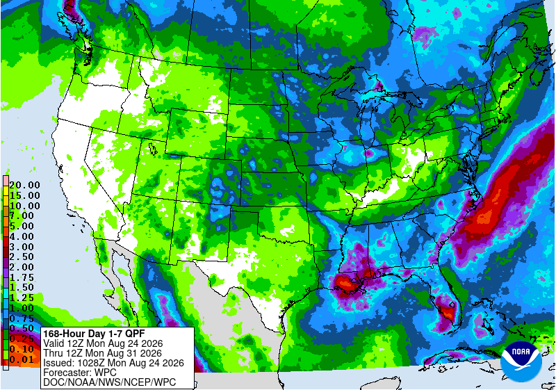
Below is the 7-day Quantitative Precipitation Forecast for the week of August 24, 2026. Precipitation is anticipated for the mountains of the South Platte River Basin and may total up to 1.50″.

Below are the 8-14 day outlooks from the Climate Prediction Center, issued August 23, 2026, for temperature and precipitation, for the week starting August 31, 2026. The CPC expects above normal temperatures and near normal precipitation for the mountains of the South Platte River Basin.

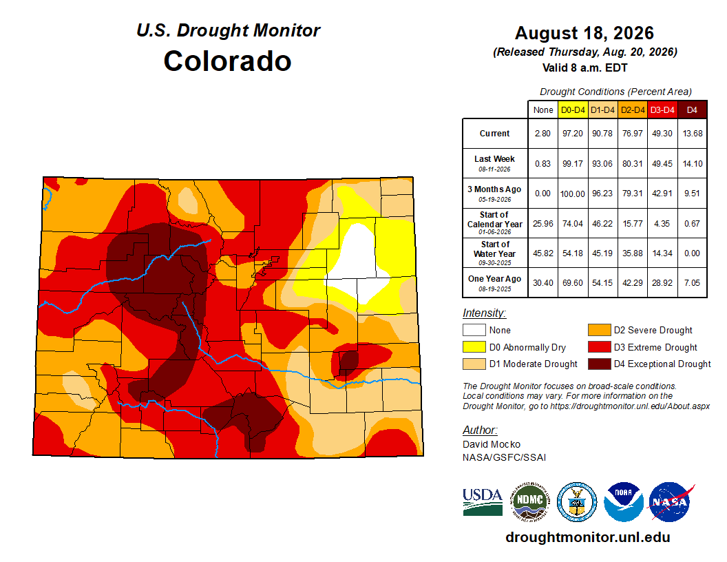
Below is the Colorado Drought Monitor map from August 18, 2026. There were one class improvements in Douglas, Arapahoe, Adams, Elbert, Morgan, Weld, Logan, and Sedgwick counties. Drought and abnormal dryness covers 97.2% of Colorado. The South Platte Basin is experiencing Abnormally Dry, Moderate, Severe, Extreme, and Exceptional drought conditions.

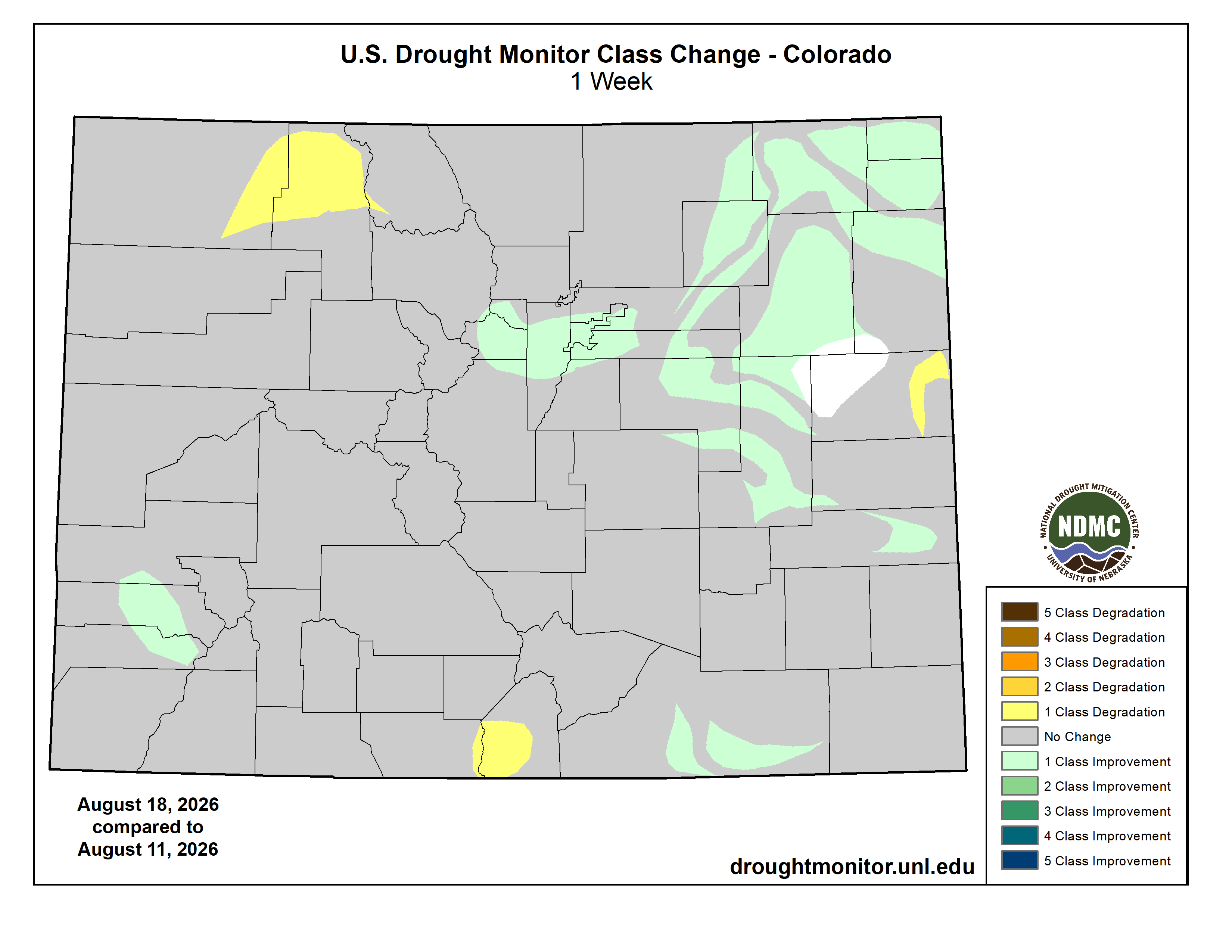
Below is the Colorado Drought Monitor one week change map ending August 18, 2026.

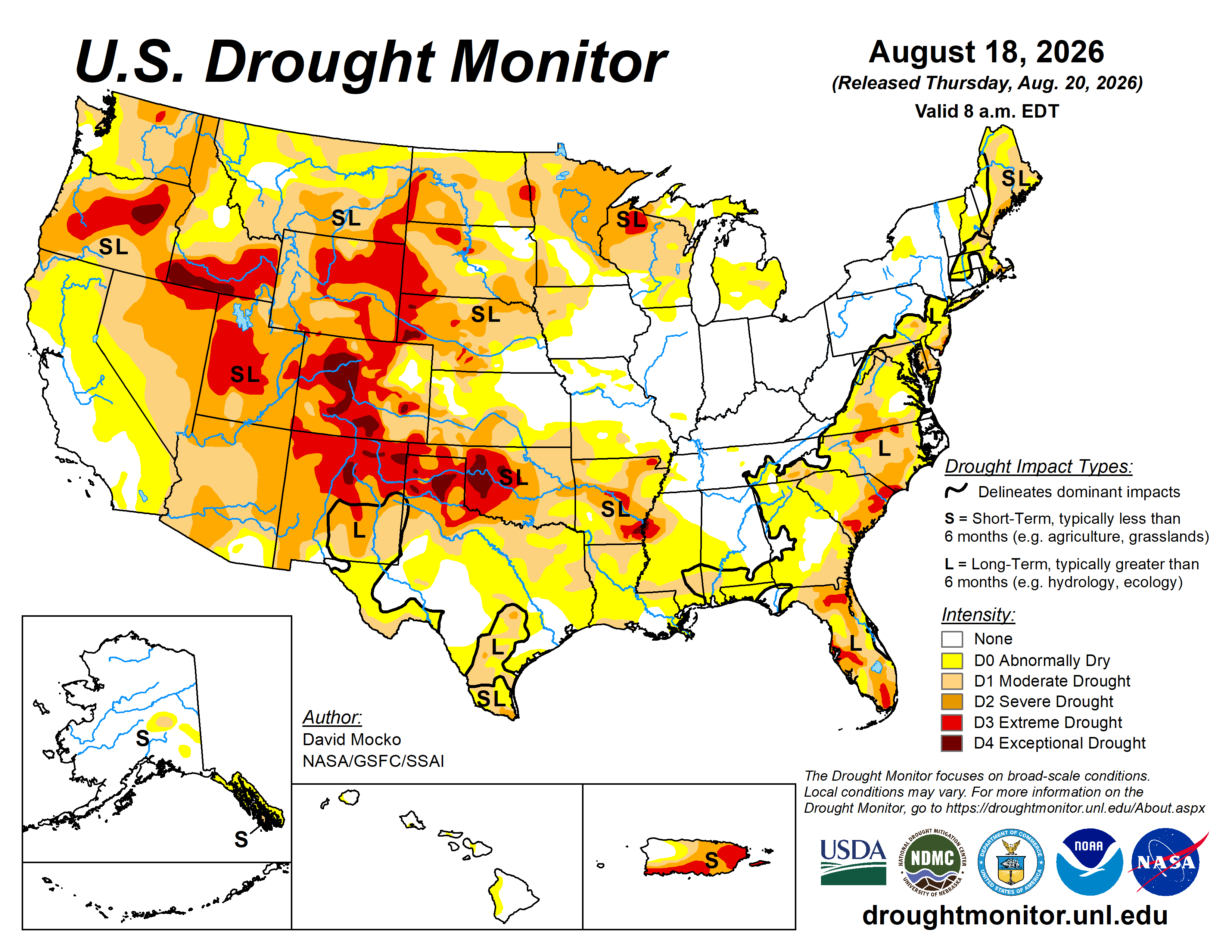
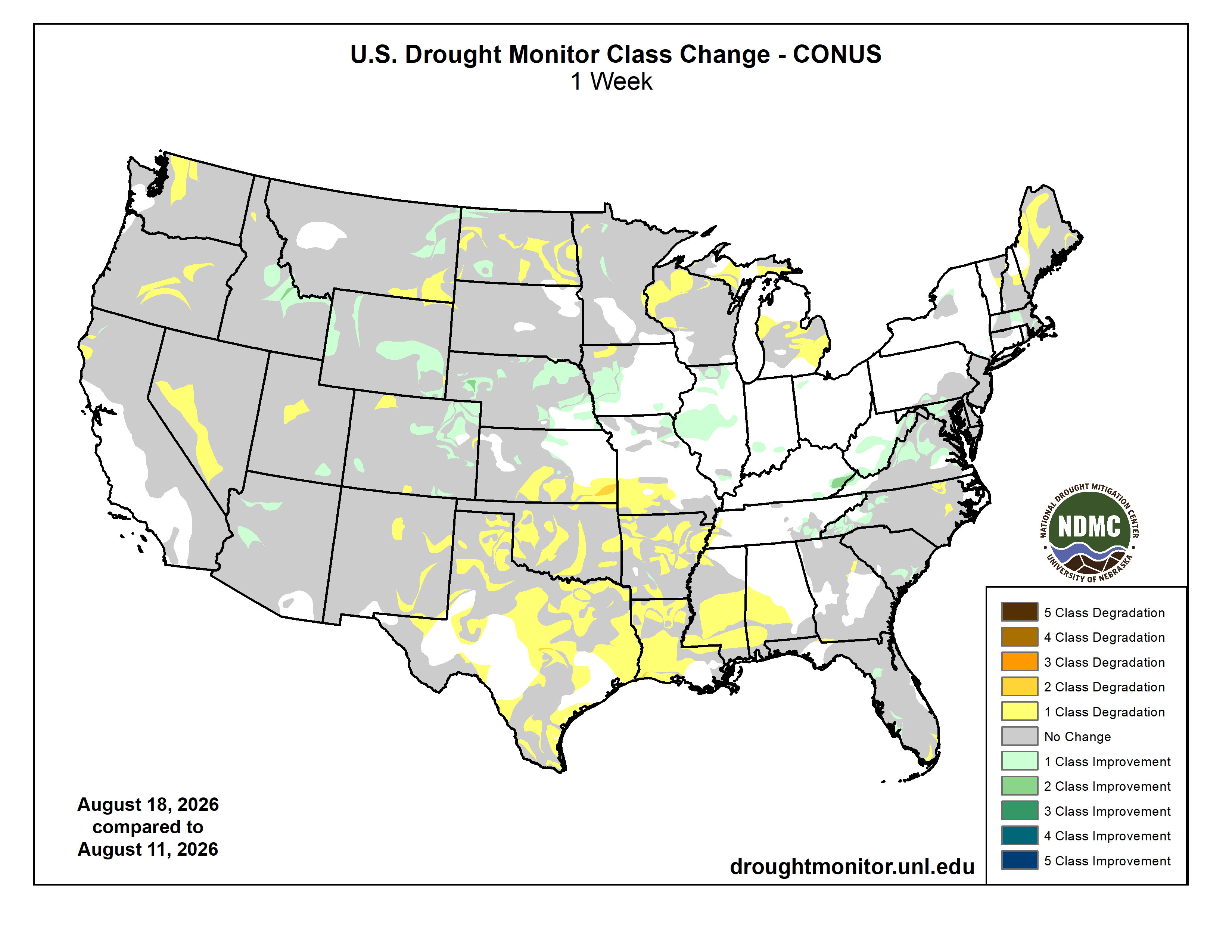
Here’s the US Drought Monitor Map from last week along with the one week U.S. change map.

Finally, last week the Climate Prediction Center issued their latest Seasonal Outlooks, through November 30, 2026. The CPC expects above normal temperatures, above normal precipitation, and drought improvement, along with some drought removal near Nebraska, in the South Platte River Basin.