When Donald Trump was elected president for the second time, we all knew what was coming to the nation’s public lands: The administration would favor extractive uses by eviscerating environmental protections, rolling back regulations, and leasing out as much land as possible while handing out drilling permits like Shriners throwing candy at a parade.
Yet there was one realm where I figured the administration couldn’t bestow any more deregulatory gifts, namely public lands grazing. It’s not that I thought Trump would clamp down on the destructive practice, it’s just that I figured the status quo was about as permissive as it could get. Past administrations, be they Democratic or Republican, have generally shied away from updating or reforming public lands grazing policies out of fear of inflaming the West’s cowboy culture — even if it is based largely on myth.
But Trump, his Interior Secretary Doug Burgum, and Agriculture Secretary Brooke Rollins are intrepidly going where previous administrations did not dare: grazing reform. Well, sort of, though maybe not in the way public lands lovers might have hoped. In fact, they are doing their best to make grazing policy even more lax with a goal of getting more cattle out there to trample public lands, cryptobiotic soils, and cultural sites.
Last month, Burgum and Rollins announced an MOU between the two agencies designed to “boost the supply of American born, raised, and harvested beef” by cutting “bureaucratic red tape” and giving the livestock industry more control. The MOU has a goal of “maintaining grazing capacity wherever possible, including no net loss of Animal Unit Months within allotments,” even if those allotments are degraded or in poor health. In Burgum’s words, one goal is to “preserve America’s ranching heritage for generations to come.” Forgive me for getting anxious whenever I see “heritage” used in conjunction with public lands.
“Today’s signing sends a clear message: the Trump administration is putting America’s farmers and ranchers first,” said Secretary of Agriculture Brooke Rollins. Which brings up the question of what message the administration was sending in February when Trump signed an executive order to quadruple beef imports from Argentina in an effort to keep Big Macs affordable.
🗺️ Messing with Maps 🧭
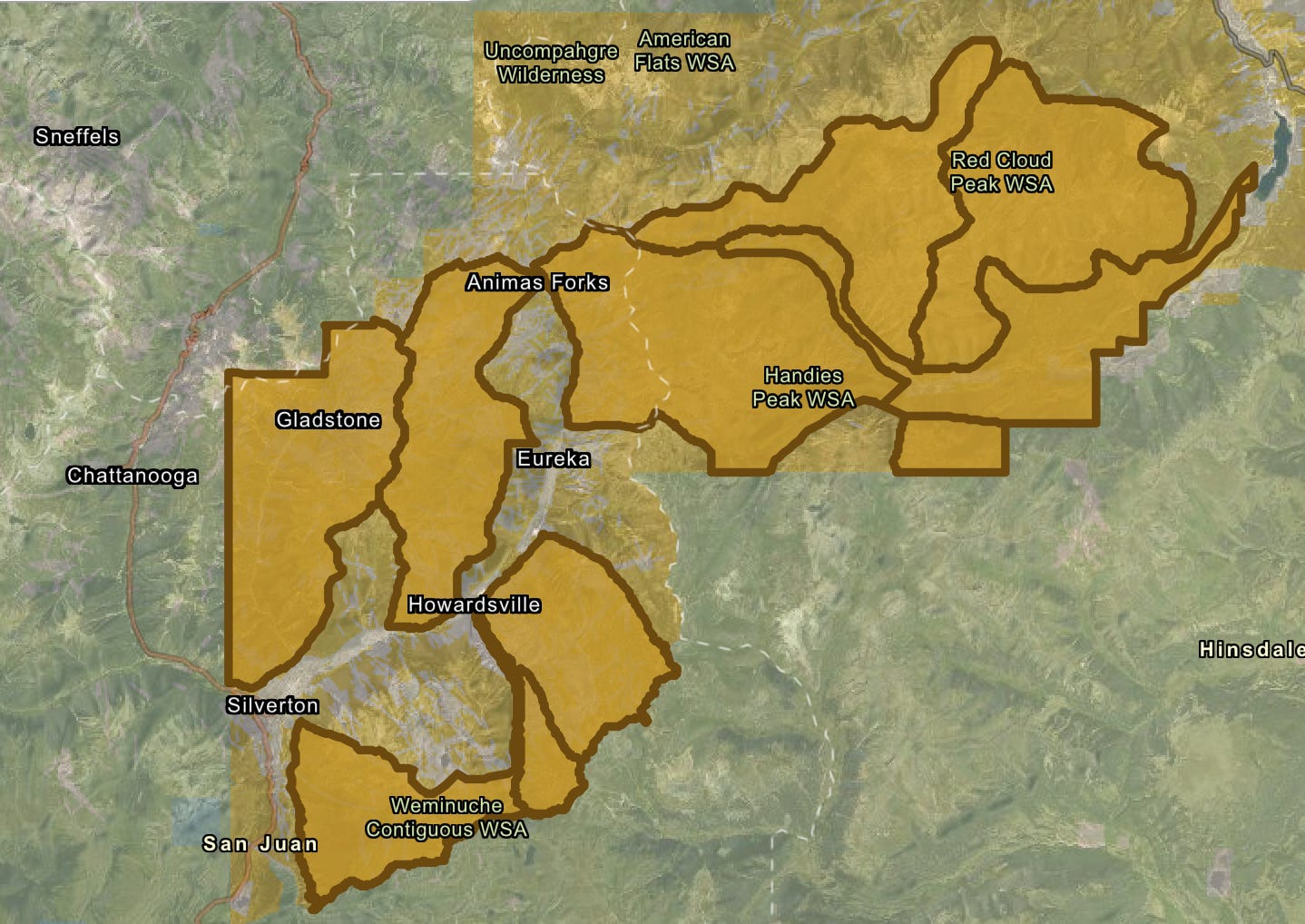
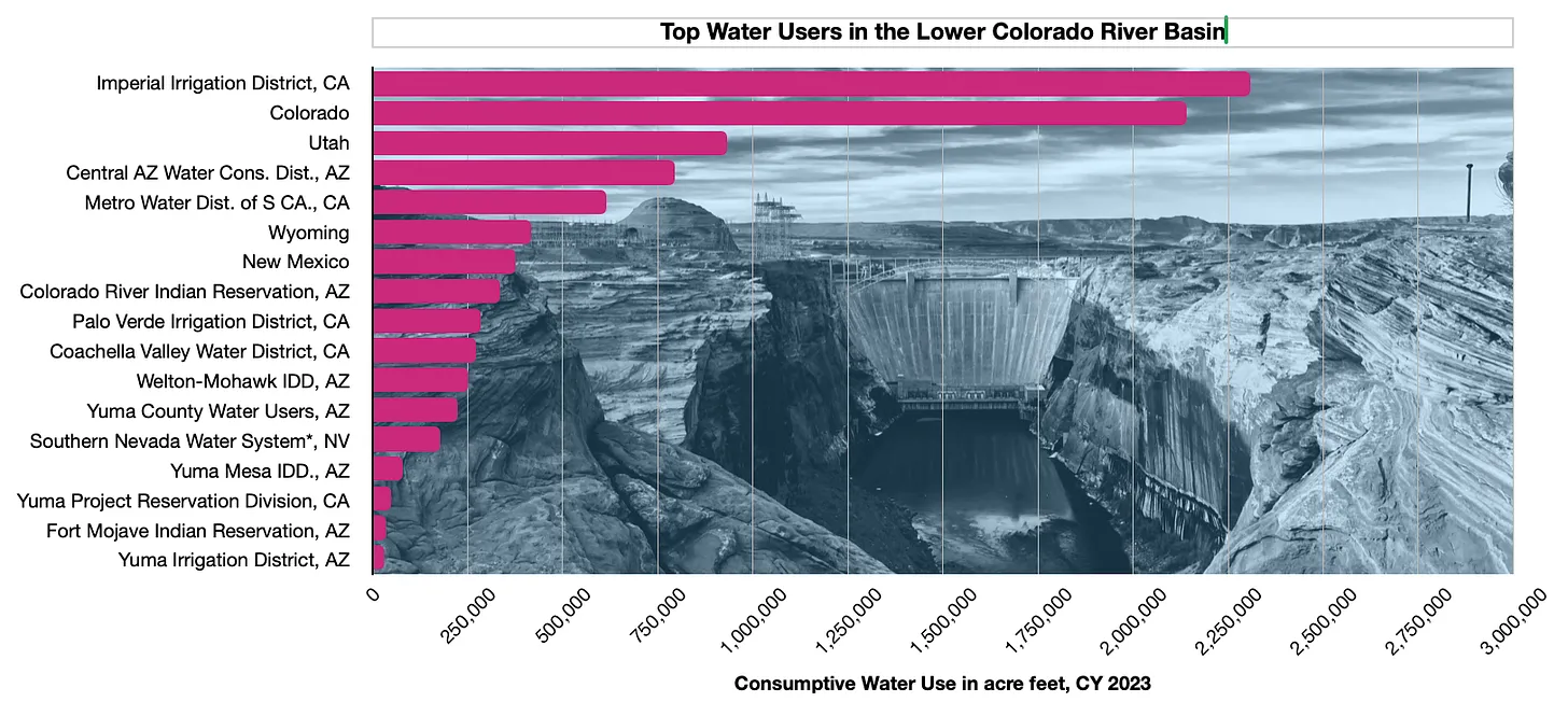
To help it carry out its mission, the Bureau of Land Management has released an interactive map aimed at putting more cattle and sheep back on public lands. The “federal grazing lands potentially available” map shows allotments that have been vacated, often as a result of deals brokered by environmentalists, with the intent of peddling the tracts to livestock operators. While there’s no guarantee that the BLM would lease out all of the vacant tracts, the presence on the map of the ones vacated for environmental purposes is enough to set off alarm bells.
Grazing allotments listed as “potentially available” for leasing on the BLM’s new map. The five parcels closest to Silverton were retired in 2023 to protect bighorn sheep. Source: BLM
For example, the map includes 10 allotments in the high country around Silverton, Colorado, totaling about 70,000 acres. In 2023, the National Wildlife Federation paid the Etchart Sheep Ranch to vacate five of these allotments in an effort to give Rocky Mountain bighorn sheep more breathing room and protect them from diseases transmitted by domestic sheep. The deal was made with the hope that the leases would be retired permanently. Yet the inclusion on the map indicates they could see domestic sheep once again, emphasizing the need for legislation that would make such retirements perpetual.
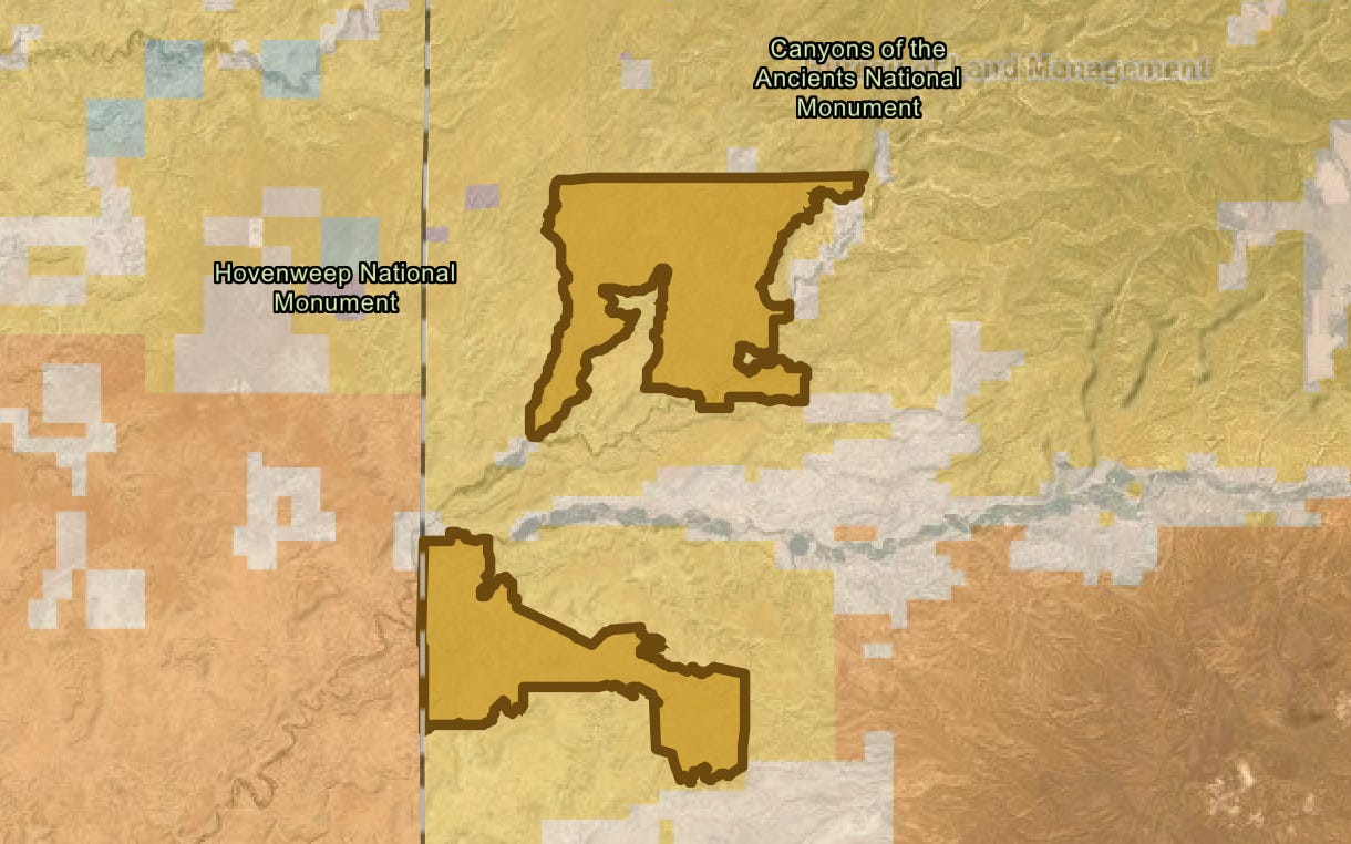
Also on the map are the Flodine Park and Yellowjacket allotments in Canyon of the Ancients National Monument near the Colorado-Utah border. In 2005, a rancher gave up the allotments, north and south of McElmo Canyon, respectively, and sold 4,500 acres of adjacent private land to the BLM to add to the national monument. Both allotments and the private land contain a number of intermittent streams, shallow canyons, and numerous cultural sites. They had been grazed relentlessly for decades prior, and showed the wear and tear—much of the cryptobiotic soil had long before been trampled and destroyed and invasive cheat grass had infiltrated the grazed areas. An archaeological assessment conducted later found grazing had damaged dozens of sensitive and cultural sites in the areas.
The Yellowjacket and Flodine Park allotments in Canyons of the Ancients National Monument. They have been vacant since 2005, and a previous effort to lease them out again was halted. Now it looks like they may be back on the block. Source: BLM
In 2010, the BLM, which manages the monument, issued a new resource management plan, which allowed for continued grazing, but also opened the door to permanently retiring vacant grazing allotments if they fail to meet BLM rangeland health standards or when grazing is negatively impacting cultural sites. Five of the 28 allotments in the most heavily visited areas—including Sand Canyon—were cancelled, but not the Flodine Park and Yellow Jacket allotments, which were still in retirement at the time.
Instead, the local county commissioners and a group of ranchers pressured the BLM to reauthorize grazing on both allotments—to bring them out of retirement, if you will. The BLM acquiesced, but environmentalists and tribes with roots in the area fought back, forcing the agency to do a more thorough environmental analysis of the proposal. The opposition was enough to prompt the agency at least to delay issuing any leases, and the allotments remain in limbo.
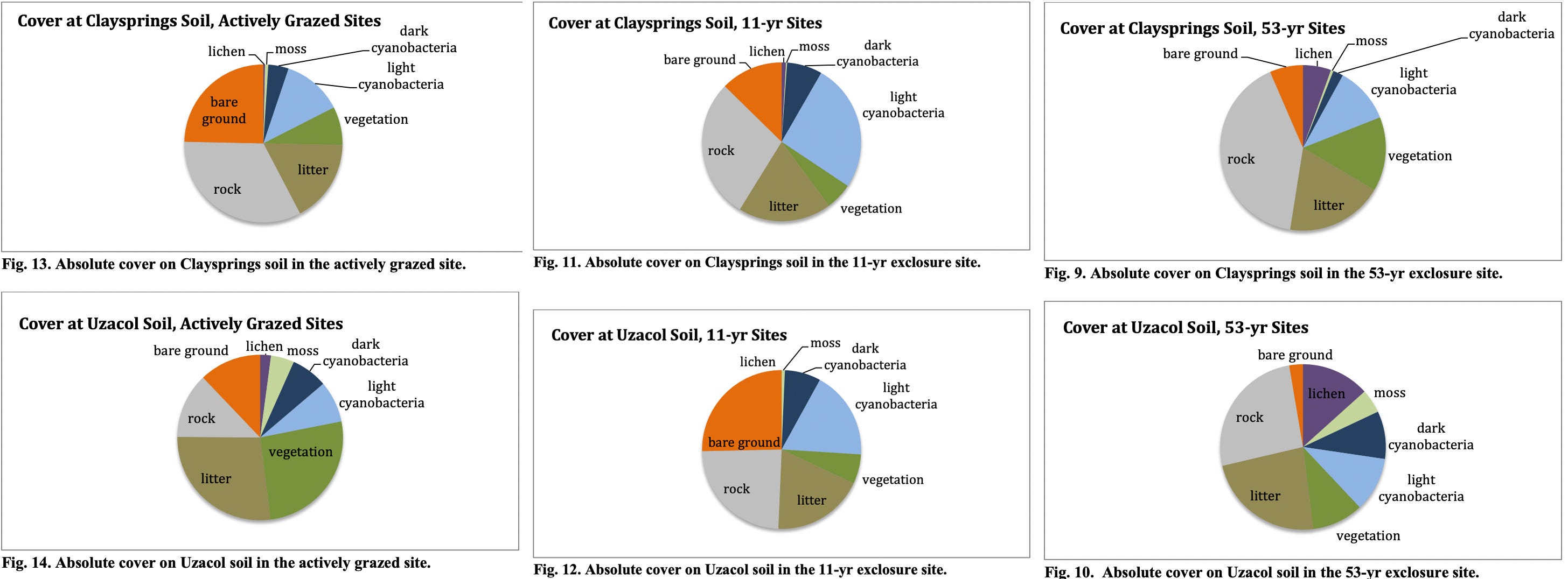
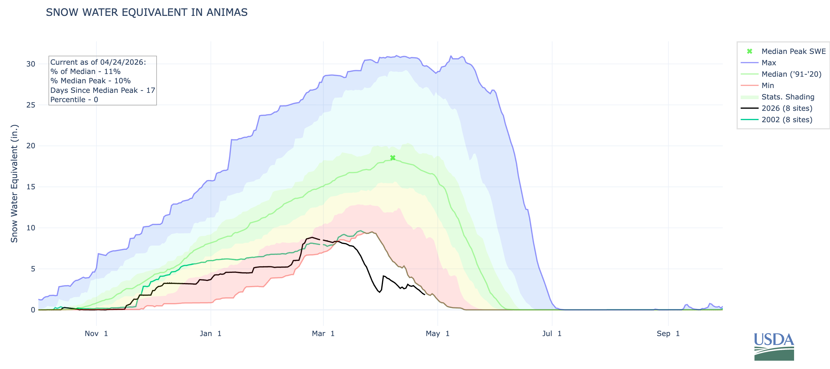
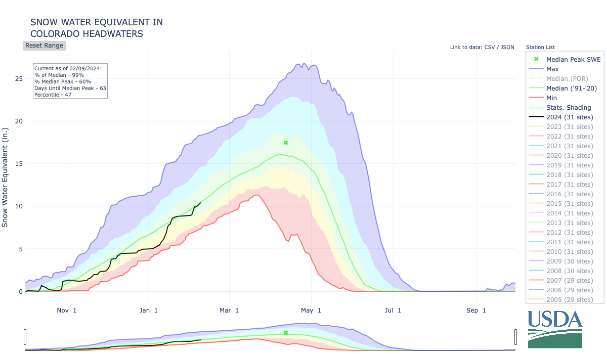
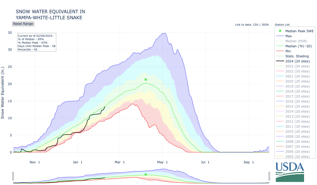
Meanwhile, a team of scientists assessed the healing process on the Flodine Park and Yellow Jacket allotments, which by then had been cow-free for 11 years (though feral horses had grazed there). They compared biocrusts on those allotments to a fenced enclosure that hadn’t seen grazing for 53 years and a plot that was being actively grazed. What they found was both predictable and remarkable: The longer a plot went without cows, the healthier it was, as summed up by these graphs.
Source: Grazing, Rest, and Biological Soil Crust in Canyons of the Ancients National Monument Marc Coles-Ritchie, Lior Gross and Mary O’Brien, Grand Canyon Trust.
While the natural landscape can eventually heal itself, livestock’s damage to the cultural landscape is irreversible. BLM surveys identified 266 cultural sites on the two allotments, including 35 with “standing architecture.” At least 43% of those had been damaged by livestock.
Now what’s left may be in danger, too, at least if those allotments’ presence on the new map is any indication. And guess what? Packing these allotments isn’t going to make that steak any cheaper. Only about 1% of American beef is grazed on public lands.
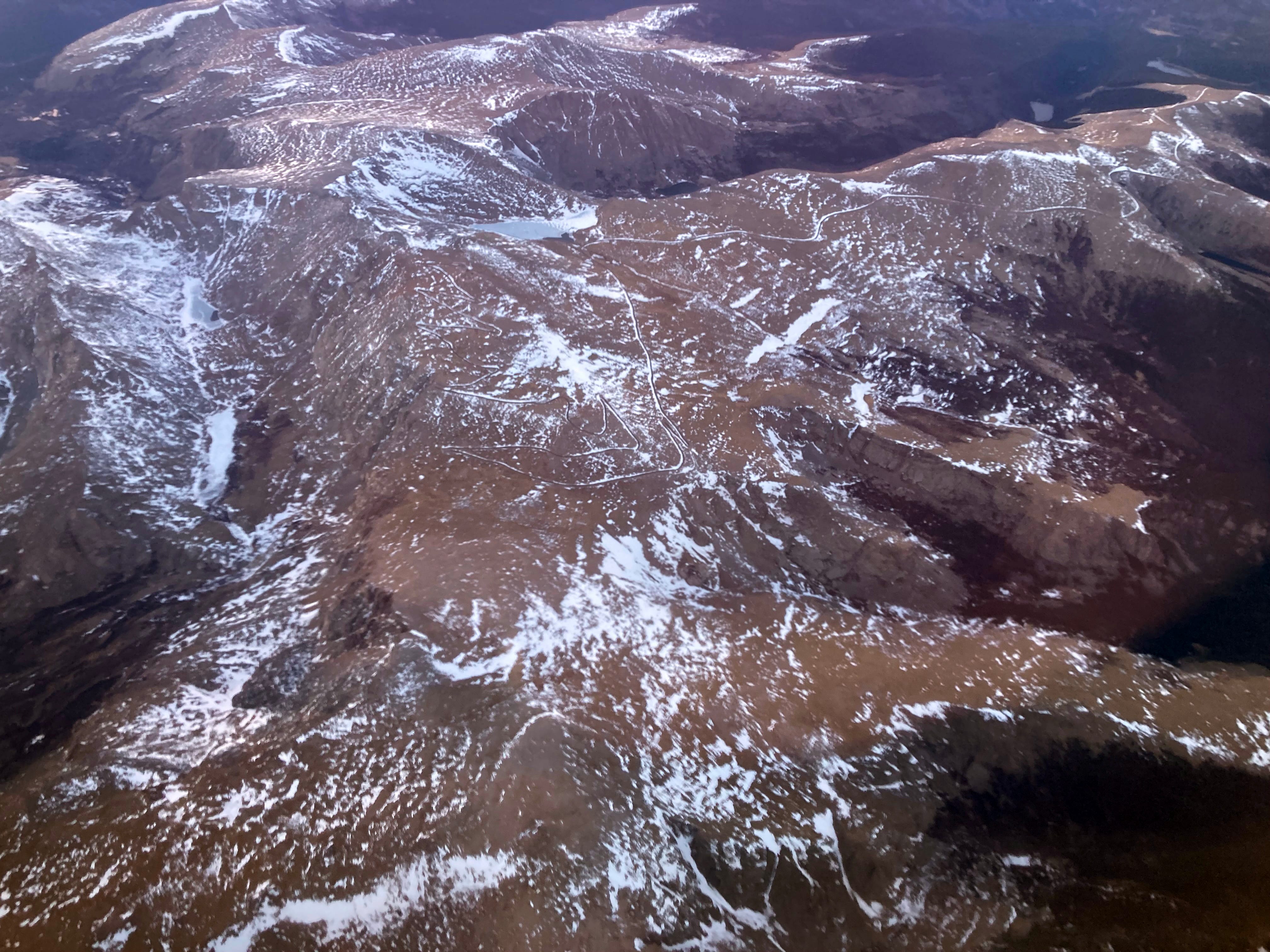
Mt. Blue Sky at 14,130 feet in elevation on April 22, 2026. Jonathan P. Thompson photo.
⛈️ Wacky Weather Watch ⚡️
If you were to get all of your information about the West’s climate from daily weather reports and road condition websites, you might think that April snow showers and deep freezes had ended the snow drought and would lead to big May streamflows. After all, it snowed enough in Colorado to turn roads to slip-and-slides and causing a 75-car pileup on I-70 near the Eisenhower Tunnel. The temperatures dropped low enough to wipe out most of the fruit blossoms the March heat wave tricked into blooming early. Only the farmers who used extraordinary measures — starting fires or smudge pots in the orchards, running wind machines, etc. — could save some of their summer harvest.
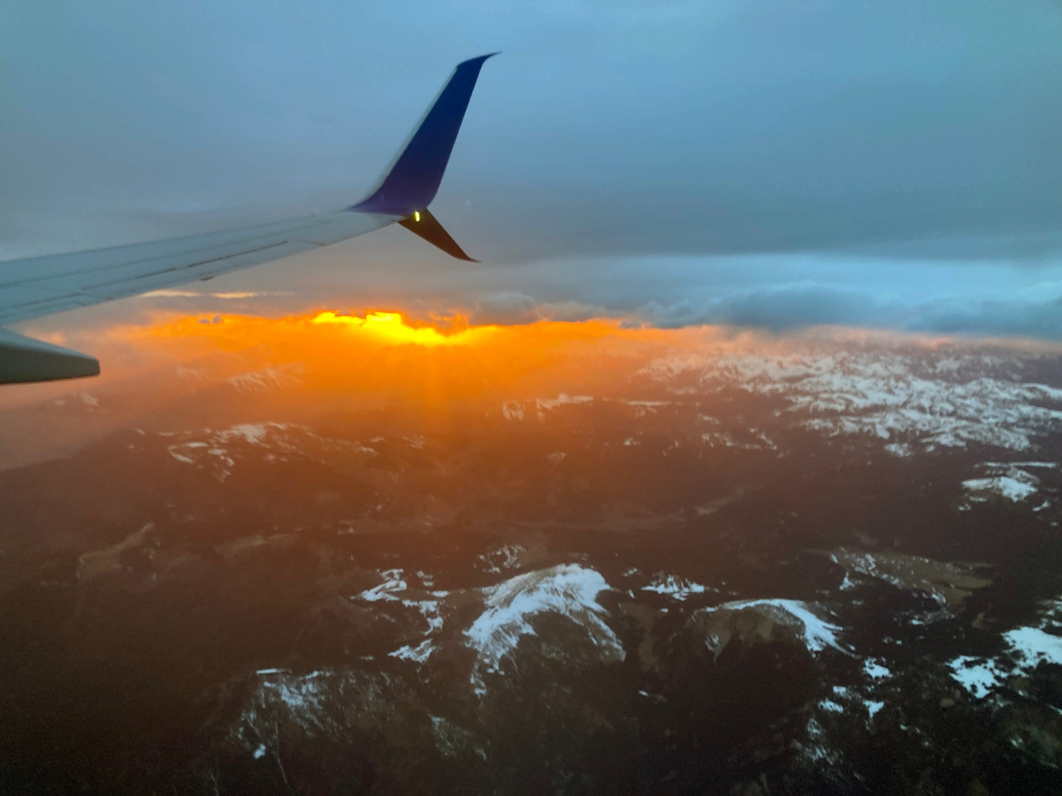
Sunset over the San Juans. Jonathan P. Thompson photo.
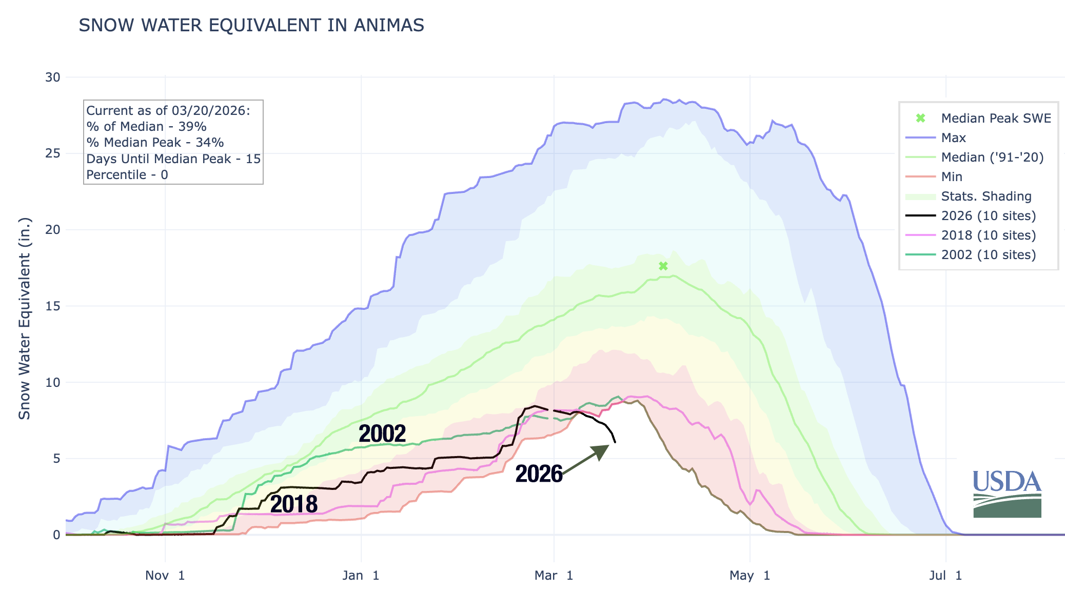
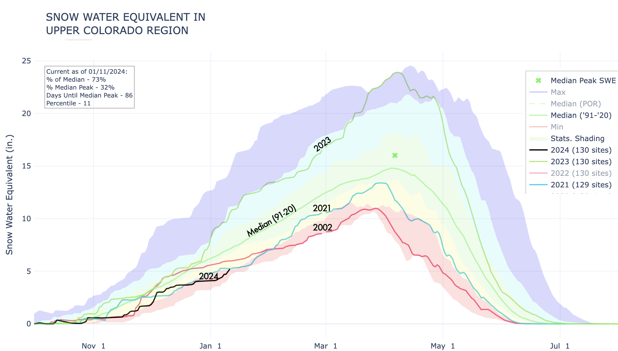
Sure, the snow that did fall in April helped, but only enough to elevate snowpack levels to, well, the lowest on record (only by a slightly smaller margin than before). And the freeze was deep, which helped extend the spring runoff in the few areas where there was any snow left. But even there, I suspect that peak runoff has already come and gone (though I’m not calling the Predict the Peak contest yet!).
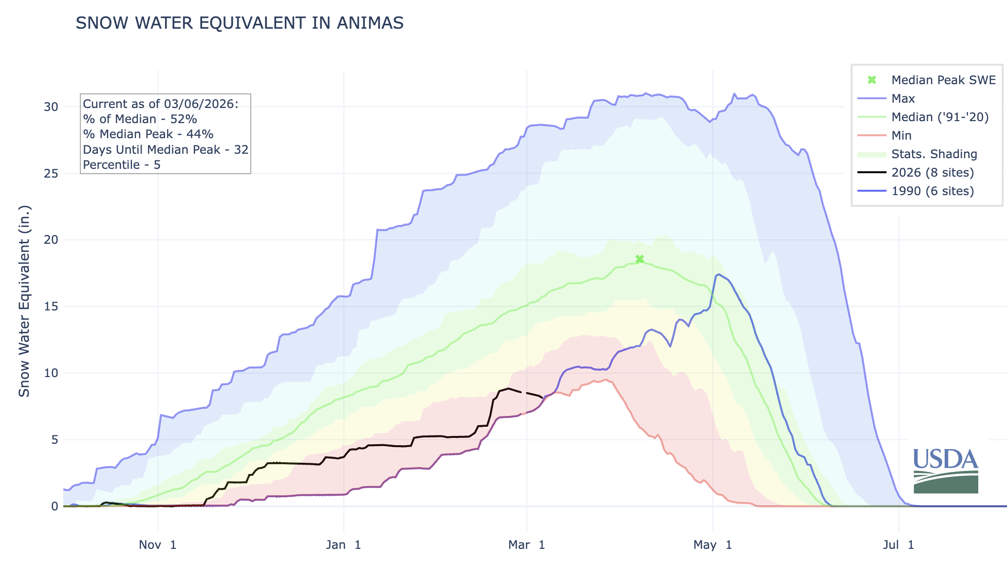
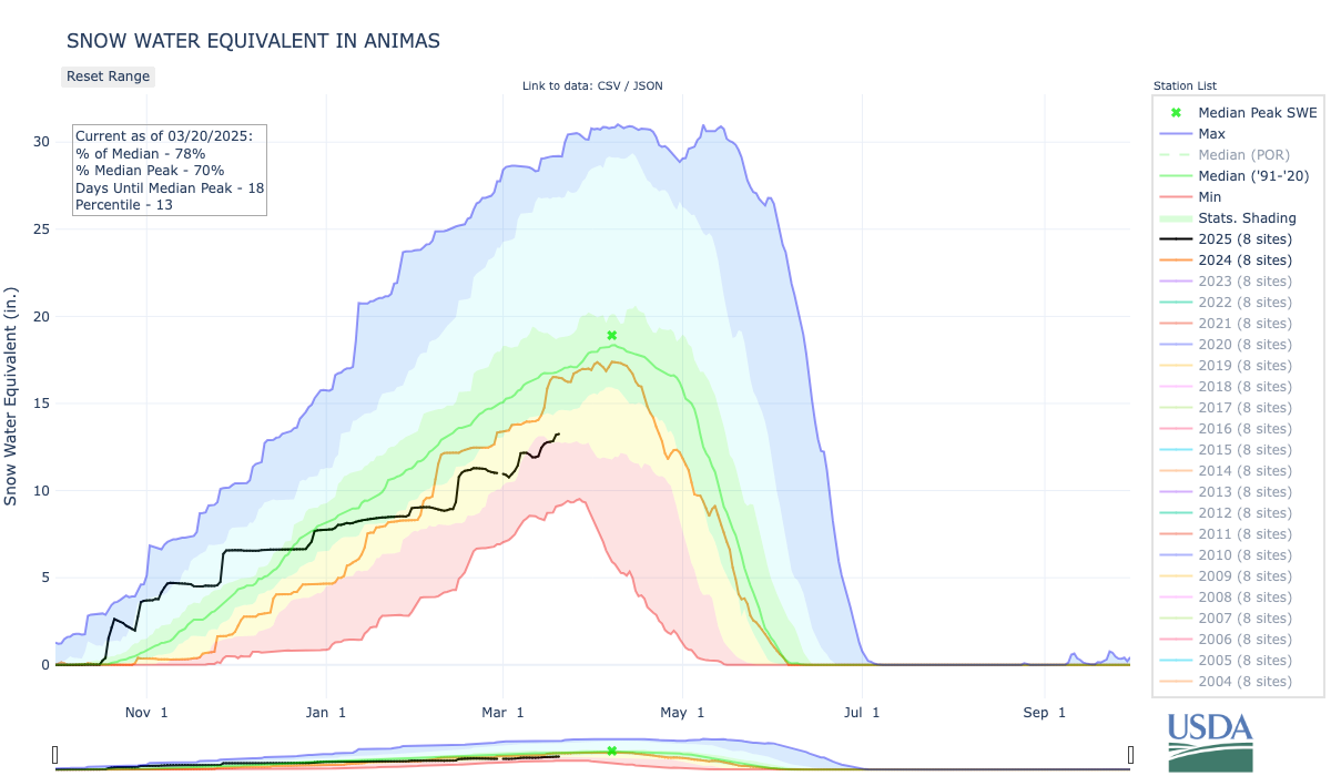
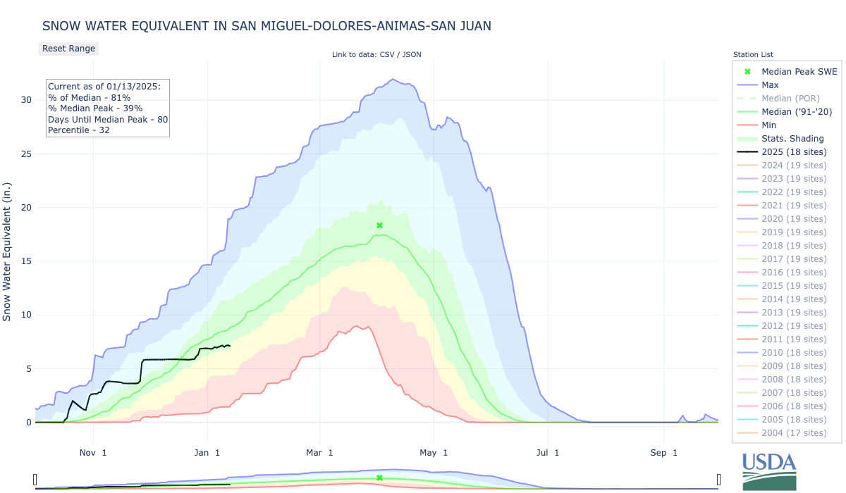
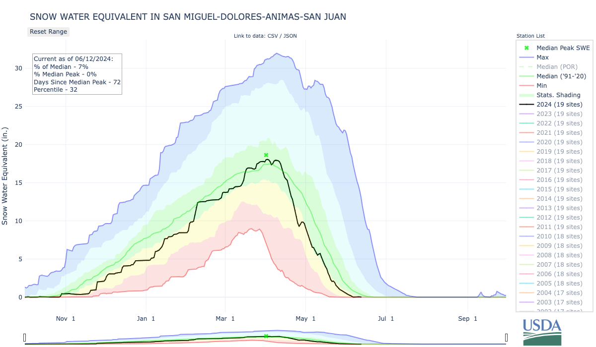
I flew over Colorado’s mountains the other day and was rather shocked at the dearth of snow, even on the highest peaks. Mt. Blue Sky, formerly Mt. Evans, had only a few patches of white left — at 14,130 feet in elevation. Everything below 10,000 feet appeared to be snowless. While the San Juan Mountains appeared to be in slightly better shape, it was still looking pretty dry. The Animas River watershed’s snowpack remains lower than it was on 2002 on this date.
It was early June, and we sat out in the shade in our backyard in Silverton, Colorado, wearing short-sleeves and shorts and drinking cold beverages under a cloudless blue sky. That, in itself, made the day memorable. Blizzards are as likely on Memorial Day as barbecues in this mountain town, elevation 9,318 feet, and sweater-free days usually don’t come along until July.
The winter of 2001-2002 had been unusually mild and a warm April and May had melted what little snow had fallen; the Animas River’s spring runoff had peaked at historically low levels a couple weeks earlier. I, for one, wasn’t too worried. By then it was understood that the climate was warming, and that it could wreak havoc on the planet, but the idea of rising sea levels and devastating heat waves felt pretty abstract in the Colorado high country. Besides, as an amateur historian, I had read accounts of similarly dry and warm winters from the San Juan Mountains’ past: In 1879, the snow was all melted from the highest peaks by May (giving way to the Lime Creek Burn that summer); sleighing was impossible” on Silverton’s streets during the 1890-91 winter; and the newspaper ran a photo of a water wagon suppressing dust on Greene Street on New Year’s Day, 1918, during “one of the most delightful winters ever experienced.”
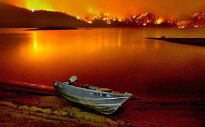
Vallecito Reservoir during Missionary Ridge Fire via George Weber Environmental.
This, it seemed, was just another one of those occasional weird years, so we figured we might as well enjoy it. Then someone noticed what looked like puffy cumulonimbus cloud rising up in the gap formed by the Animas River gorge. It wasn’t a cloud at all, but a billowing tower of smoke from the Missionary Ridge Fire, ignited that afternoon on a slope about 35 miles south of where we sat. Over the coming weeks, the blaze would eat through 73,000 acres of parched scrub oak and aspen and conifer forest, along with 83 structures. It eclipsed the 26,000-acre Lime Creek Burn as the state’s largest wildfire on record, but lost the title to the Hayman Fire (138,114 acres) that was burning at the same time across the state.
Aerial view from the south of Hayman Fire June 30, 2002. Road traversing from left to right is U.S. Highway 24. Town of Manitou Springs is in lower part of photo, Colorado Springs to the right. Garden of the Gods park defined by three upright orange rock formations in right center just below smoke line. Creative Commons Attribution-Share Alike 4.0 International license.
And it was then that we realized this was no normal abnormality, and that 2002 would go down as the Water Year of our Discontent: dry, smoky, and catastrophic for irrigators and river rafters alike.
This year is shaping up to be even more dire. Indeed, with temperatures in Silverton climbing into the 60s this week, I’m sure a few people have shed some layers and soaked up the sun — in March. Now, however, we know that this is no anomaly, but part of a long-term trend toward aridification, most likely caused or at least exacerbated by climate change. Call it the “new normal” if you’d like, but just remember the words of Bruce Cockburn: “The trouble with normal is it always gets worse.”
I wanted to wait until April to give this assessment, on the off chance that the weather might shift radically in the last days of March in a way that might give us all some hope. While anything’s still possible, I’ve seen enough to bet that, unfortunately, we may already have seen peak snowpack in many places, making this the driest water year on record by far. And besides, I wanted to get the spring runoff “predict the peak” streamflow contest going before, well, the streamflows actually peaked.
A crappy snow year does not necessarily lead to a nasty fire season, since so many other factors come into play. The same can sort of be true about the peak of the spring runoff. That’s more about timing: A fast melt after a dry winter can result in a bigger, albeit short-lived, peak, than a slow melt of a relatively abundant snowpack. The river’s average flows across the entire water year are much more closely tied to snowpack, but those can also be affected by a big monsoon season.
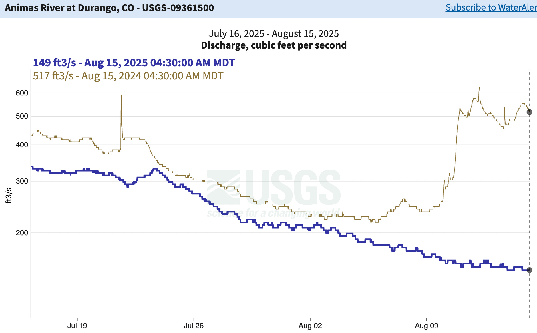
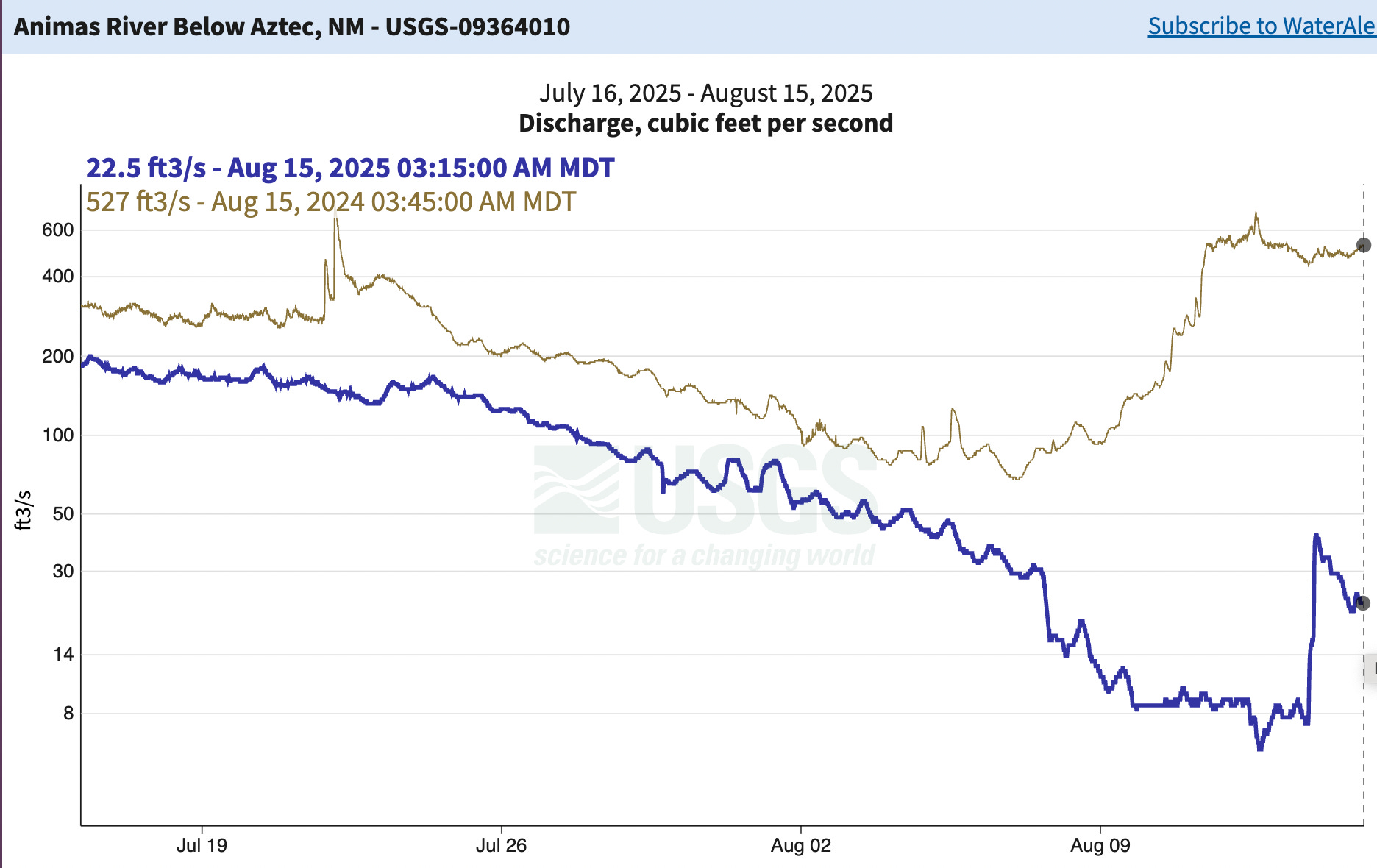
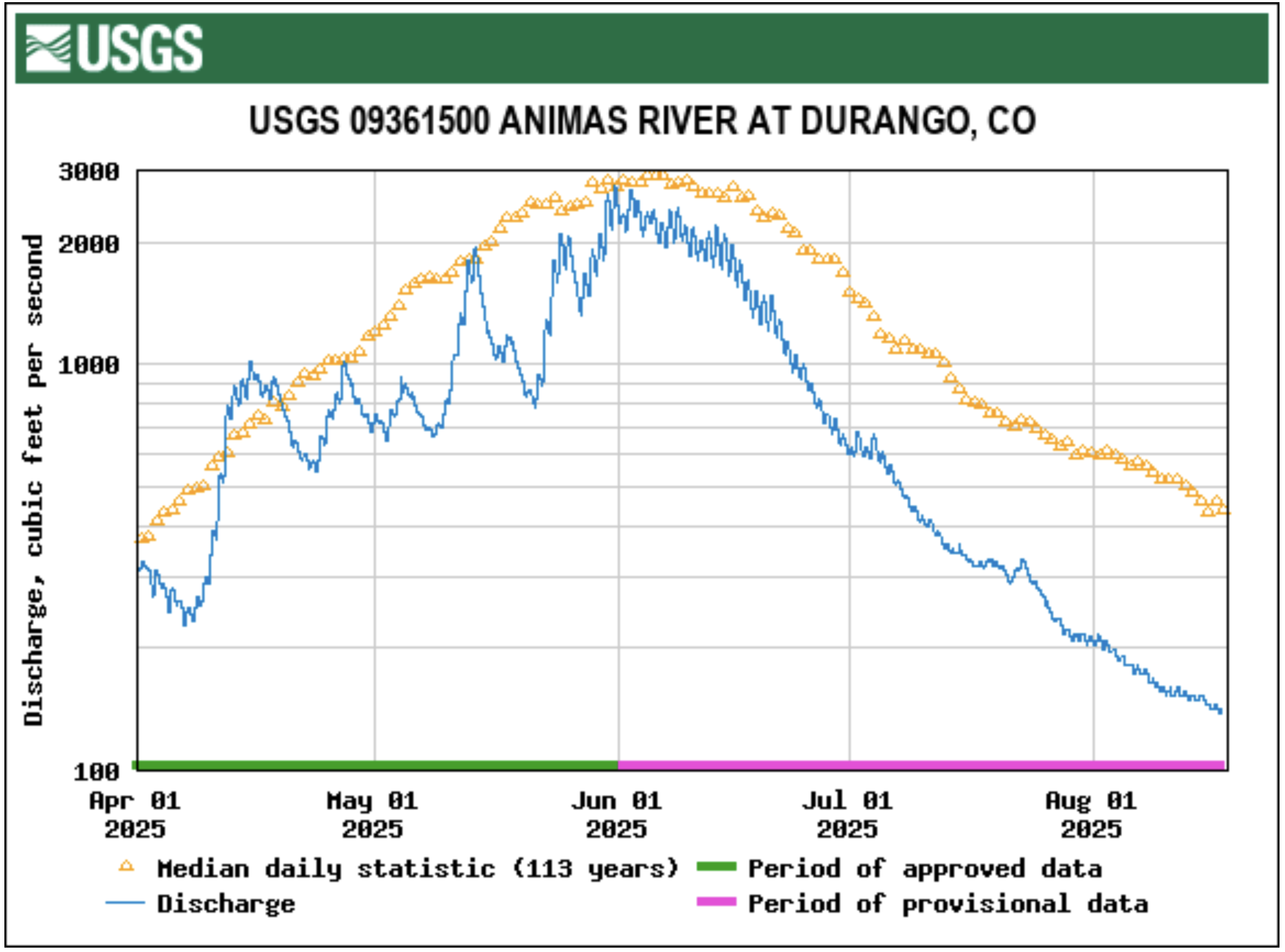
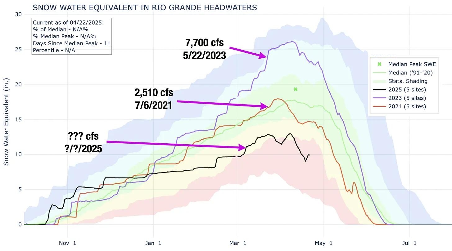
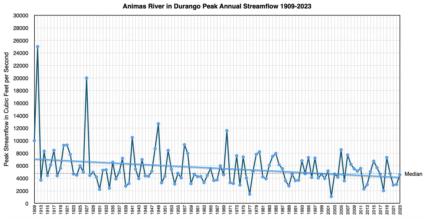
Still, looking back at similar years in the past can help with predicting flows this year. I’m going to focus on the Animas River in Durango, because it’s my home river, it is unimpeded by dams or major upstream diversions, and it is a good proxy for a lot of other Southwestern rivers, since its headwaters are located in the same mountain range as those of the Rio Grande, the Gunnison, the Dolores, the San Miguel, the San Juan, and the Uncompahgre rivers. If the runoff is weak in the Animas, it is also likely to be weak in all of those other rivers.
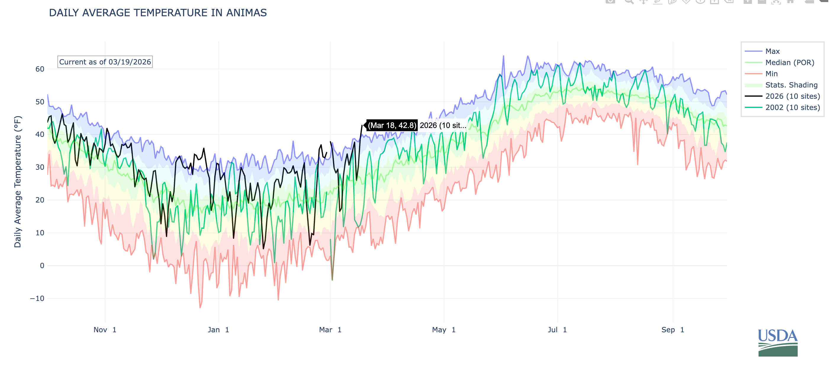
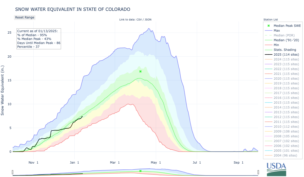
The snowpack graph shows that the current heat wave has really taken a toll, and probably launched the spring runoff.
Here’s the temperature graph for the Animas watershed. You can see that it reached a record high for the date of 42.8° F. That doesn’t seem too warm until you consider that the median temperature for March 18 is about 25° F. Probably more significant than this one little blip is the fact that daily temperatures have far exceeded “normal” on dozens of days this winter. Also note the contrast with 2002 (the darker green line).
When you talk to Colorado climate folks and old-timers with good memories, you’ll often hear that the 1977 water year was even drier than 2002. Unfortunately, SNOTEL records typically go back only to the early 1980s, so it’s difficult to make a good apples-to-apples comparison. But by looking at the “natural flow” of the Colorado River, which is the calculated estimate of how much the river would carry without any human intervention, it appears that 1977 was, indeed, the driest winter across the Upper Colorado River Basin since at least 1900.
However, historic Animas River flow data suggest that 2002 was actually drier in southwestern Colorado.
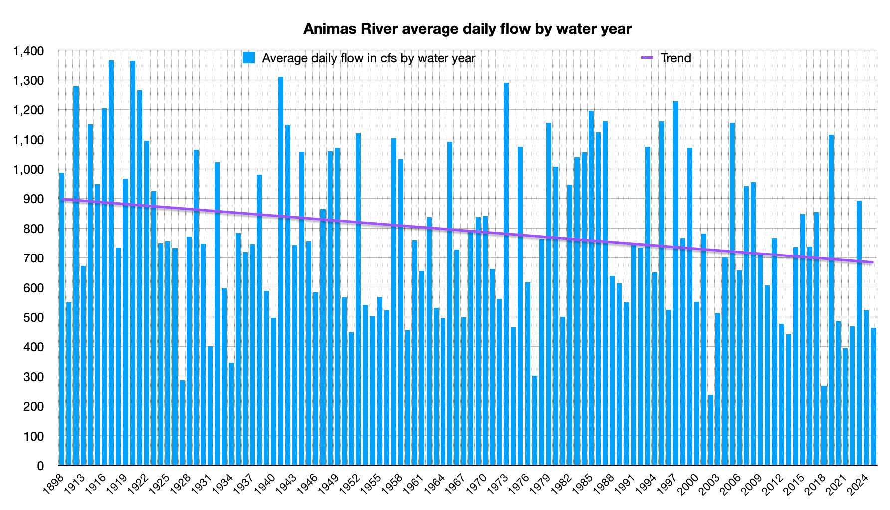
Here’s the average annual daily flow for the Animas. Note that there are several years missing between 1898 and 1911; apparently the USGS did not record flows during those years.
Average stream flows on the Animas River have trended downward over the last century and some, but the river has struggled through extreme dry years in the past. Source: USGS.
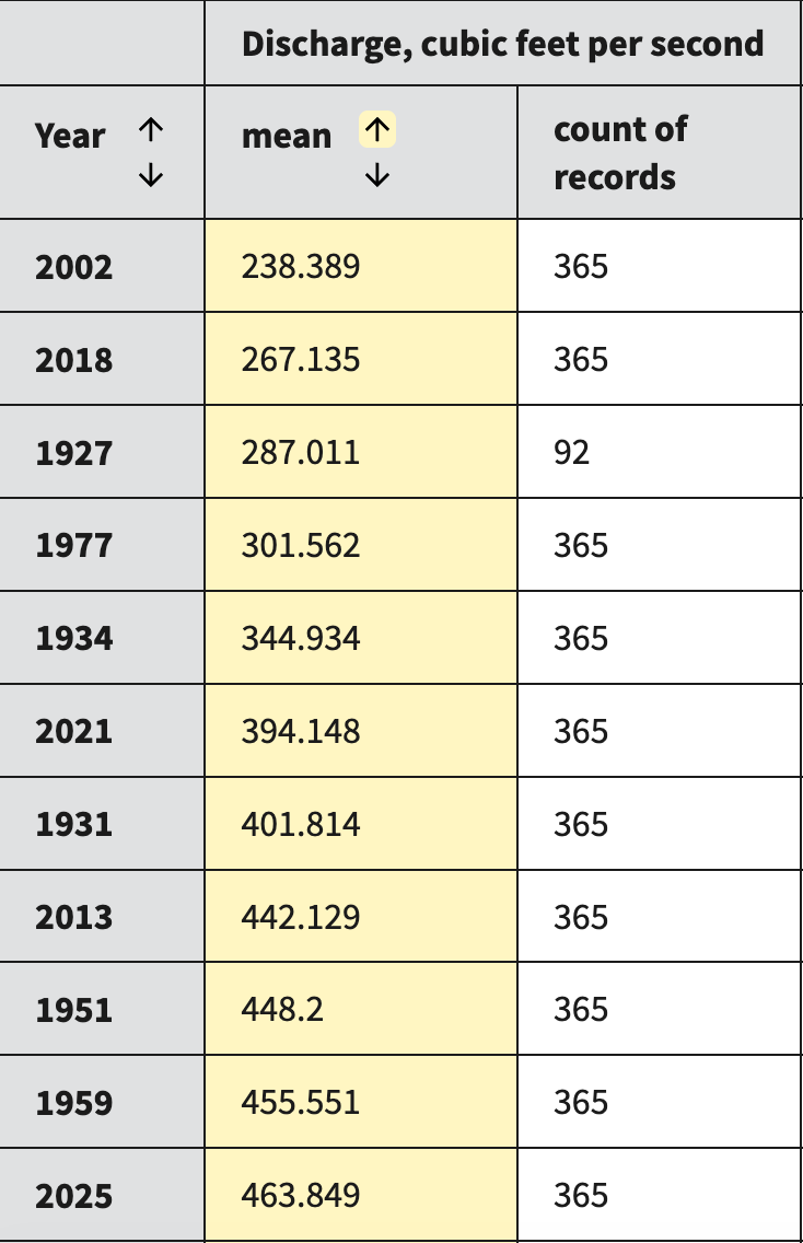
Because that graph isn’t so easy to read, here’s a table showing the eleven lowest average daily flow water years. Note that in 1927 they only had 92 records, potentially skewing the results. The 2002 and 2018 water years were lower than in 1977. If snowpack levels correlate with annual average flows, then we could expect this year’s to be around 200 cfs, which is pretty damned dismal.
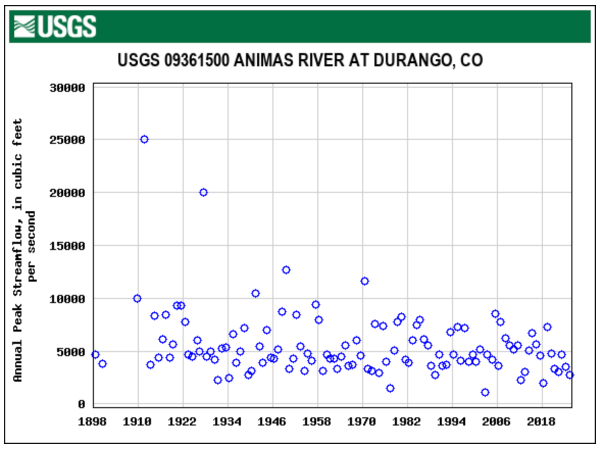
When I took a look at the peak streamflows for the Animas, I was a bit taken aback to see that in 2002 it topped out above 1,000 cfs, which is more than I would have expected.
Then I saw the date: It peaked in September, after the monsoon arrived, not in the spring. The 2002 spring runoff actually topped out on May 21 at 880 cfs, which was far lower than the 1977 spring peak.
Based on all of that, my Animas River peak streamflow prediction is a bit wacky, but I’m standing by it: It will top out at 700 cfs on April 15.
The rest of the Land Desk community will have a chance to predict the peak starting next week, when I’ll announce the terms, the river gauges in the contest, and the prizes for the winner(s). Most likely it will only be open to paid subscribers, so the time to upgrade is now!
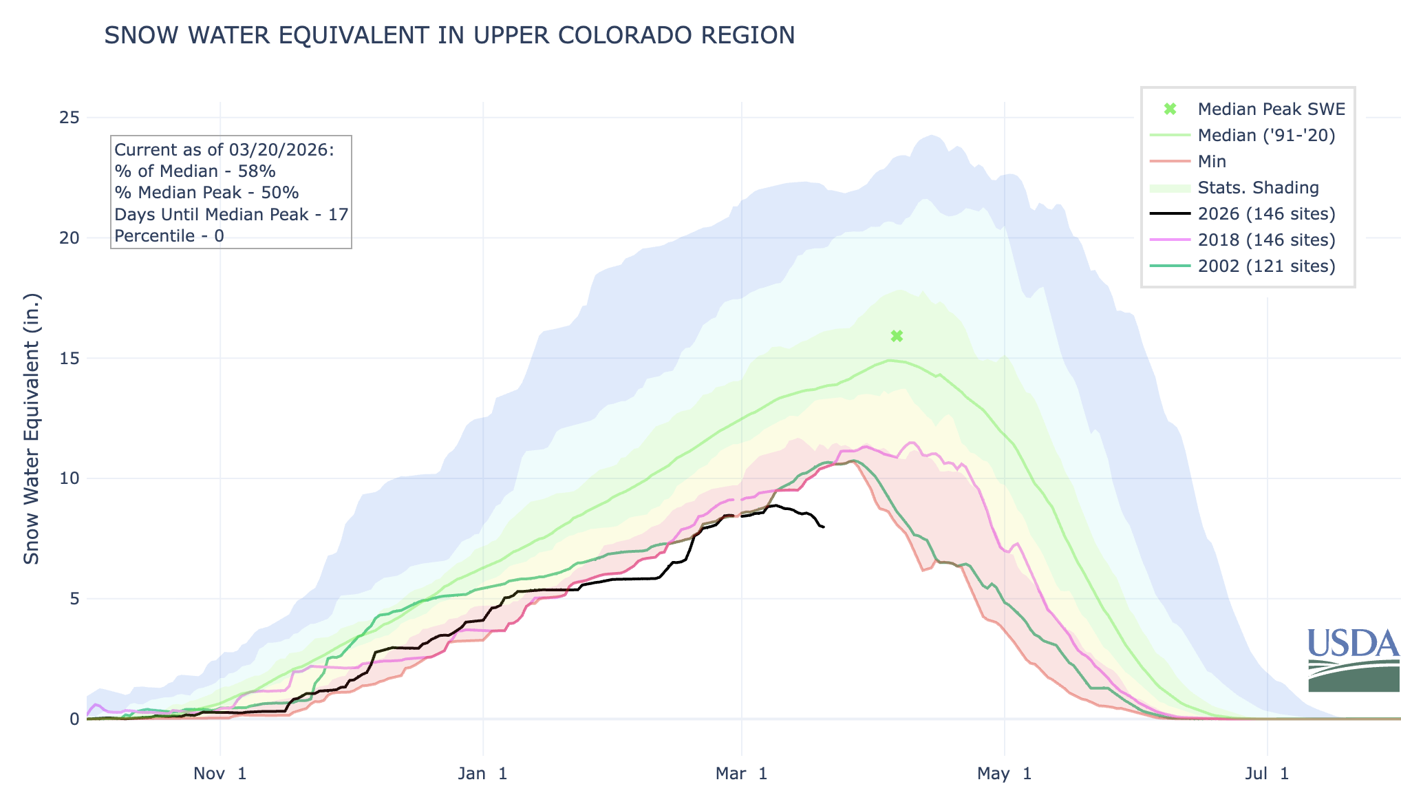
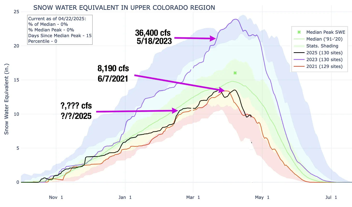
We might as well get even more depressed. Here’s the snowpack graph for the Upper Colorado River Basin, showing 2026, 2002, and 2018 — i.e. the dismal years. Note that the spring melt has begun in earnest. If it continues at this rate, runoff will be over by early May.
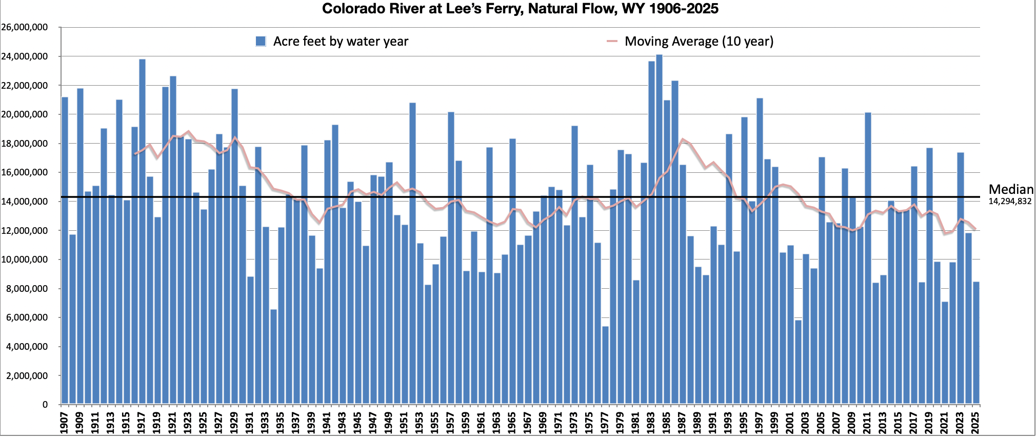
And here’s the natural flow graph for Lees Ferry on the Colorado River. Natural flow is the calculation of how much water would be in the river at that point if there were no human diversions or consumptive use upstream. If you compare this to the historic streamflows on the Animas River, you’ll notice that there is a correlation, but it’s not direct. For example, 1977 was the driest year on record for the Colorado River as a whole, with a total volume of just 5.4 million acre-feet, which is about half what the Lower Basin alone was using throughout the 1990s.
The ten lowest years on record are:
1977: 5.4 MAF
2002: 5.9 MAF
1934: 6.6 MAF
2021: 7.2 MAF
1954: 8.3 MAF
2012: 8.4 MAF
2018: 8.5 MAF
2025: 8.5 MAF (provisional)
1981: 8.6 MAF
1931: 8.9 MAF
It looks like we could be in that 5.4 MAF territory once again. That wasn’t a huge deal in 1977, since it was an anomaly. It is a big deal now.
And just so you know, it’s not just the Colorado River watershed that’s in trouble. Even California, which got pummeled by atmospheric rivers, is losing its snow rapidly.
📖 Reading (and watching) Room 🧐
The Upper Basin and Lower Basin may not have come up with a deal yet on how to save the Colorado River’s massive plumbing system, but they are looking for solutions. One of them is creating an Upper Basin conservation pool. Like a lot of issues related to the rivers, it’s a slightly complicated one. But Heather Sackett of Aspen Journalism gives a really great rundown. She’s always a must-read for those looking to understand what’s going on with the Colorado.
🗺️ Messing with Maps 🧭
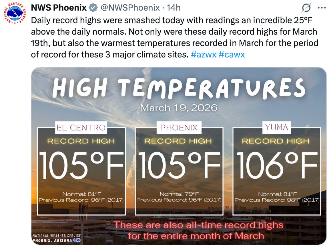
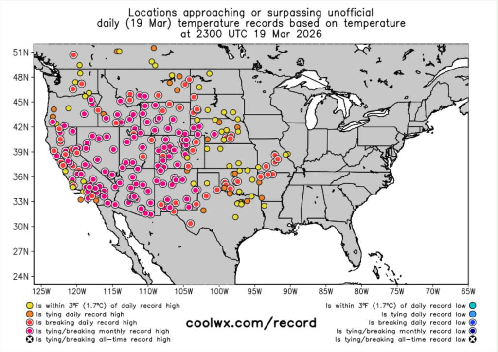
The current heat wave is breaking records across the West. Here’s a little sampling:
If you want a quick and comprehensive look where those records were broken during the last day, week, or month, check out coolwx.com/record. In the side panel you can click on the United States and the time period you wish to see and it will show an animation of all of the records. It looks kind of like this:
Sen. Mike Lee and Rep. Celeste Maloy, both MAGA Republicans from Utah, have formally introduced legislation to use the Congressional Review Act to revoke the Biden-era management plan for Grand Staircase-Escalante National Monument. If successful, the move would also bar the feds from developing a new management plan that resembles the current one.
The current management plan is not draconian by any means. It was fashioned over years, with oodles of input and compromise, and is far less restrictive than the preservation-oriented alternatives It allowed for motorized vehicle use on designated routes and added almost no new restrictions for livestock grazing. Revoking it is not the same as rescinding the national monument or shrinking its boundaries, and will not open up any of the monument to new mining claims or oil and gas leases.
So it’s not clear what Lee and Maloy hope to achieve, except to strike a blow to a national monument that they don’t like and to throw oversight of 1.9 million acres of public land into disarray. Or maybe they’re just trying to build up their anti-public-land credentials to head off challenges from even more extreme candidates such as, say, Phil Lyman, who just challenged Maloy for her 3rd District congressional seat.
You still have time to let your representatives in Congress know how you feel.
Ugggg.
While well-intentioned greens are parsing BLM director nominee Steve Pearce’s words for indications he might be inclined to sell off public land, the Trump administration is orchestrating a massive de facto transfer of public lands to oil and gas companies.
I’m talking about oil and gas leasing. And no, it’s not an actual transfer of public land; the lessee does not take title to the land, nor can they block public access, but they do get the rights to drill that land and preclude other uses on it. And, once it is drilled, the land is scraped of all vegetation, covered with heavy equipment, poked with a massive drill, hydraulically fractured, and becomes an industrial-scale, methane-, hydrogen sulfide-, and VOC-oozing hydrocarbon factory for many decades to come.
On the auction block this June is a good chunk of slickrock-studded landscape northwest of Moab, between Hwy. 191 and the Green River, along with some parcels in the Lisbon Valley. All in all, the BLM proposes selling off 39 parcels covering some 71,600 acres. You have until March 30 to give your two cents. https://eplanning.blm.gov/Project-Home/?id=6fad61fa-a7f2-f011-8407-001dd80bcf93
***
Of course, sometimes the BLM holds an oil and gas auction and no one comes. That was the case with the Big Beautiful Cook Inlet Oil and Gas Lease Sale (yes, that is the official name) held March 4 in Alaska, in which more than 1 million acres of offshore leases were put on the block. There were zero bids. Zilch. Nada. Someday, maybe every oil and gas lease sale will be like that.
***
A federal judge has halted construction of the Northern Corridor Highway through the Red Cliffs National Conservation Area near St. George, Utah, while an advocates’ lawsuit proceeds.
The BLM approved the contested project earlier this year. The Utah Department of Transportation, apparently wanting to get started before a legal challenge could take hold, began erecting fencing along the project, even though their development plan hadn’t been approved. This activity would have disturbed desert tortoise habitat.
The court did not approve, blocking further work until the lawsuit is resolved.
***
In other Utah road news, Garfield County began chip-sealing the first ten miles of the Hole-in-the-Rock Road in Grand Staircase-Escalante National Monument, drawing protest and a lawsuit from environmental groups.
The county has been aching to pave the gravel road, which often becomes riddled with potholes and washboards, for years, but failed to gain BLM approval. Environmental groups have resisted, saying that improving the road could lead to more paving or widening of primitive byways in the area, and would increase the number of people and their impacts on the fragile landscape.
The county has also wielded RS-2477 — an 1866 statute — in an attempt to wrest control over the byway, which leads to the famed Colorado River crossing of the 1879 Latter Day Saint expedition to Bluff. Last July, a federal court granted Garfield County quiet title to the section of the road within the county.
Garfield County interpreted that as a green light to chip seal the road.
That triggered a lawsuit from the Southern Utah Wilderness Alliance, pointing out that because the road crosses BLM land, the county must still get the agency’s go-ahead for major improvements. It didn’t, but the BLM has done nothing to stop the action, which SUWA says violates federal environmental laws.
🥵 Aridification Watch 🐫
I was accused recently of being all “doom and gloom” when it comes to this year’s snow levels, so I set out to find some good news to report. It didn’t go so well, but I did uncover a few tiny nuggets, including:
After the February storms, the Center for Snow and Avalanche Studies reported: “This is rare, but currently we do not have any dust on the snowpack.” That’s good news because dust on the snow decreases albedo (reflectivity), leading to faster snowmelt. We need what little we have to stick around as long as possible. Buzzkill: The really big dust events tend to come in the springtime.
I tend to rely on a handful of high-elevation SNOTEL sites as indicators of how the mountain snowpack is doing. One of them is in Columbus Basin in the La Plata Mountains. Like everywhere else, the snow water equivalent there is way below normal. However, it’s still above 2002 levels for early March, so that’s kind of heartening. I guess?
Hope lies in 1990: That year, snowpack levels in the Animas River watershed were lower on March 6 than they are today. But beginning in mid-March, storms pummeled the region, resulting in a May 3, 1990, snowpack peak that was 94% of normal and bringing runoff up to decent levels. We could see a repeat of that March-April-May miracle!
And … oh. I’ve just been informed that there is no more good news.
As grim as this may be, it also offers a glimmer of hope: The snowpack could still recover like it did in 1990. Source: NRCS.
Now back to our regularly scheduled doom and gloom, bullet style.
The late February-early March heat wave across most of the West shattered thousands of daily high temperature records and dozens of monthly ones, topping off the West’s warmest winter on record. Monthly records (121 tied or broken nationwide during the last week of Feb.) include:
Dinosaur National Monument in Utah hit 68° F on 2/26;
Imperial County, California’s airport reached 97° on 2/28;
Albuquerque airport, 77° on 2/25;
Hovenweep National Monument in Utah, 70° on 2/28;
Havasu, Arizona, and Malibu Hills, California, were both 93° on 2/27;
Sampling of daily records (845 broken or tied during the last week of Feb) include:
Mancos, Colorado, hit 50° F on 2/28; the aforementioned Columbus Basin (elev. 10,784 feet) reached 48° and Mineral Creek, Colorado, hit 51° that same day;
McClure Pass, Colorado, reached 49° on 2/28;
Needles, California, and Phoenix both hit 92° on 2/28;
South Lake Tahoe airport, 60° on 2/28.
Those kinds of temperatures melt the snow, even on north faces, causing this year’s snow water equivalent graph lines to uncharacteristically dip during a time of year when they normally would be shooting upward. They also heighten risk of wildfires in the low country. On the last day of February, a blaze broke out in Chautauqua Park in Boulder, forcing some evacuations before it was contained. Another one was sparked west of Boulder on March 4.
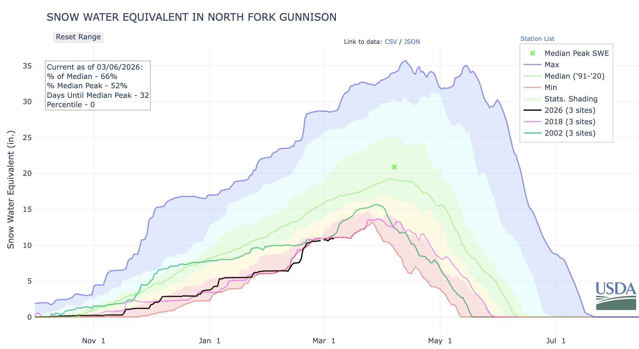
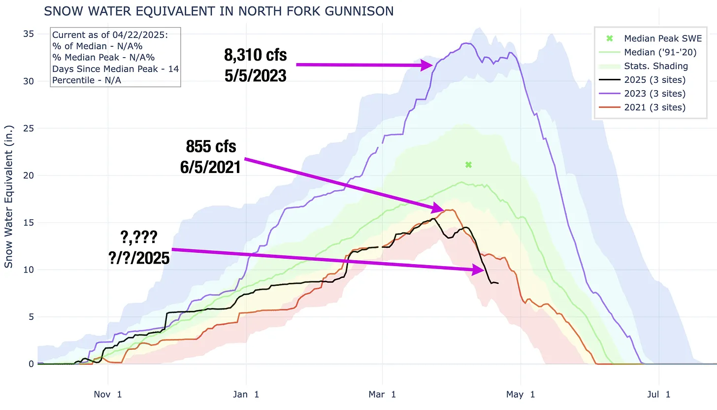
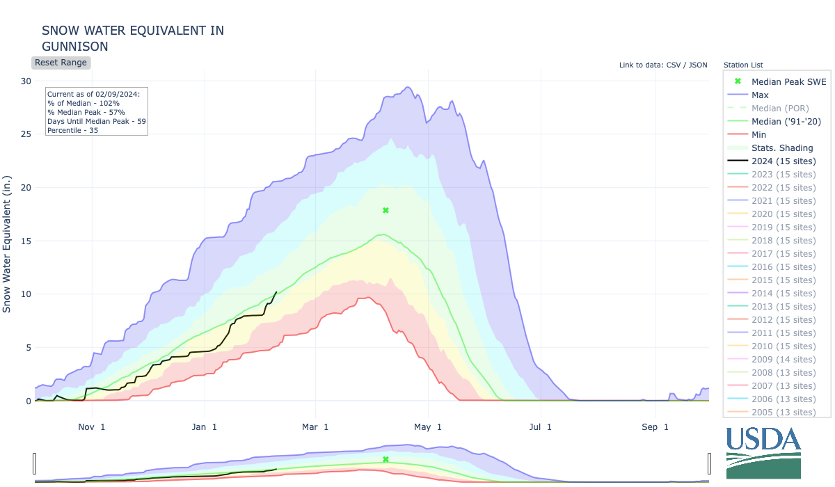
The North Fork of the Gunnison, which feeds the ditches in and around Paonia and Hotchkiss and the orchards, vineyards, and farms there, is in trouble. This year’s snowpack so far is in the same boat as it was on this date in 2002 and 2018, two very dry years when irrigation ditches were shut off early in the growing season.
Aside from the entire Upper Colorado River watershed, I’m also especially concerned about the North Fork of the Gunnison. Snowpack levels are at a record low for this date, or about the same as they were in 2018, and Paonia Reservoir is currently utilizing just 22% of its storage capacity (note the record high temp on McClure Pass above, at the headwaters of Muddy Creek, which feeds the reservoir). This does not bode well for the many small farmers who rely on the river for irrigation. In 2018, downstream senior rights holders made a call on the river in June, forcing junior irrigators in the North Fork to lose water perilously early in the season.
This bad situation could be exacerbated if the feds were to decide to release water from Paonia Reservoir in an attempt to buoy Lake Powell water levels. While this is hypothetical, it is not beyond the realm of possibility by any means.
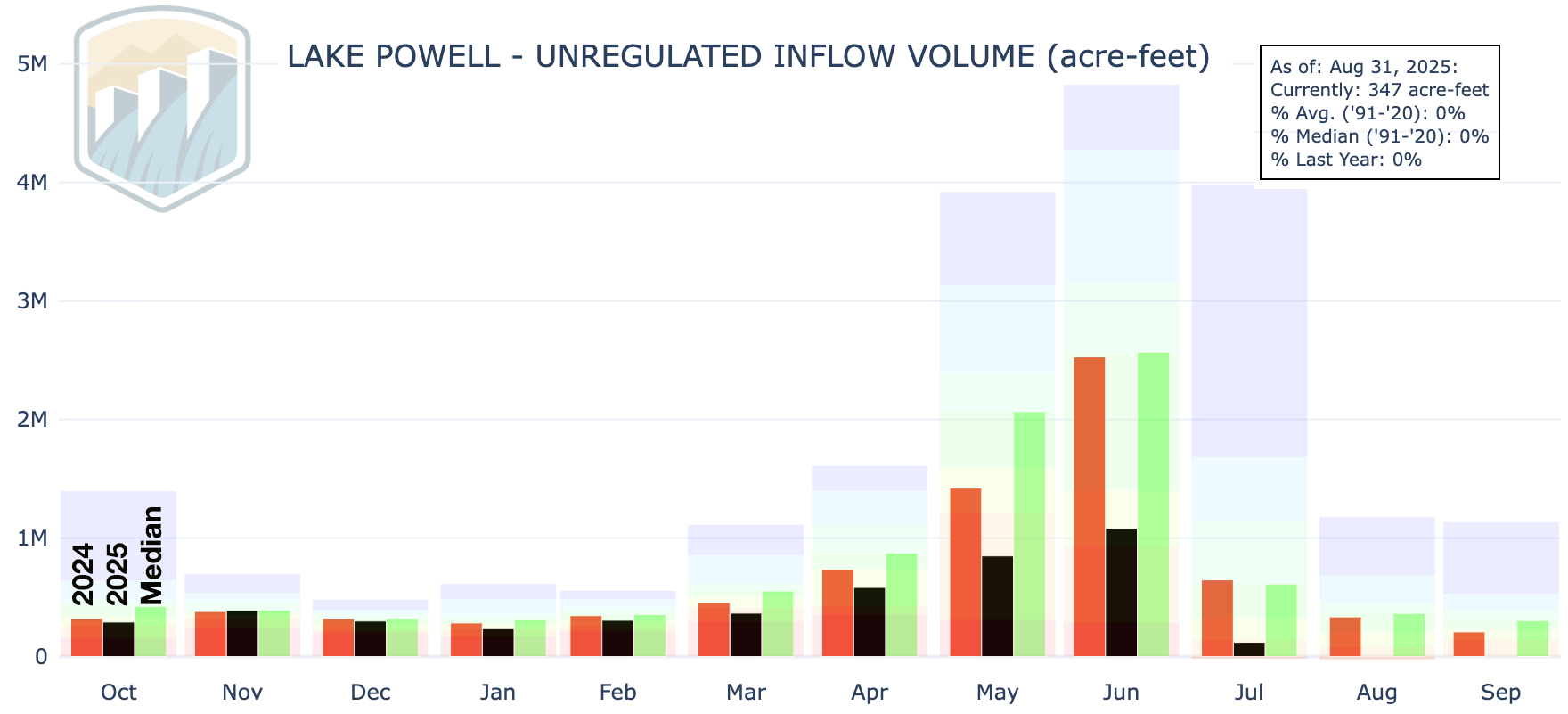
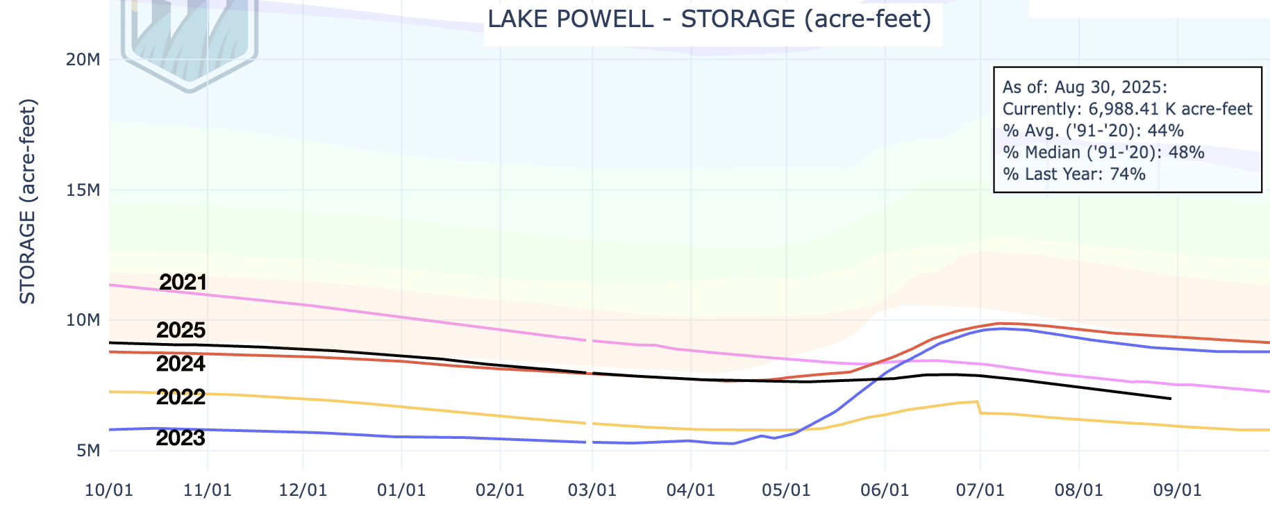
And, saving for some sort of April-May miracle, the Colorado River runoff will be extraordinarily scant this spring and summer, almost certainly pushing Lake Powell to critically low levels.
***
That demands a plan, and the Bureau of Reclamation came up with several alternatives last month. Most of the major players have commented on the alternatives, and it’s safe to say that almost no one is satisfied with any of them — albeit for different reasons.
One of the more universal critiques is that none of the alternatives adequately address dry and critically dry scenarios on the river, like the one that is likely to occur this summer. The draft environmental impact statement itself states, “In critically dry periods, all alternatives have unacceptable performance.” That leaves many wondering what, exactly, the Bureau of Reclamation plans to do to keep the system from collapsing over the next nine months.
There is a lot here, and it gets pretty darned deep in the wonk weeds. Still, what I’ve included is a mere sampling of some of the comments from just a few of the commenters in the hope that it will give readers a better idea of where different stakeholders stand, and how complicated and difficult this situation really is.
For those who don’t like weeds, here’s the short version: It’s a tangled mess with a bunch of moving pieces and stakeholders who are digging in their heels to ensure that their constituents get the water they need to drink, irrigate crops, run industries, or whatever. And they’re all butting up against the reality that there simply isn’t enough water in the river to go around.
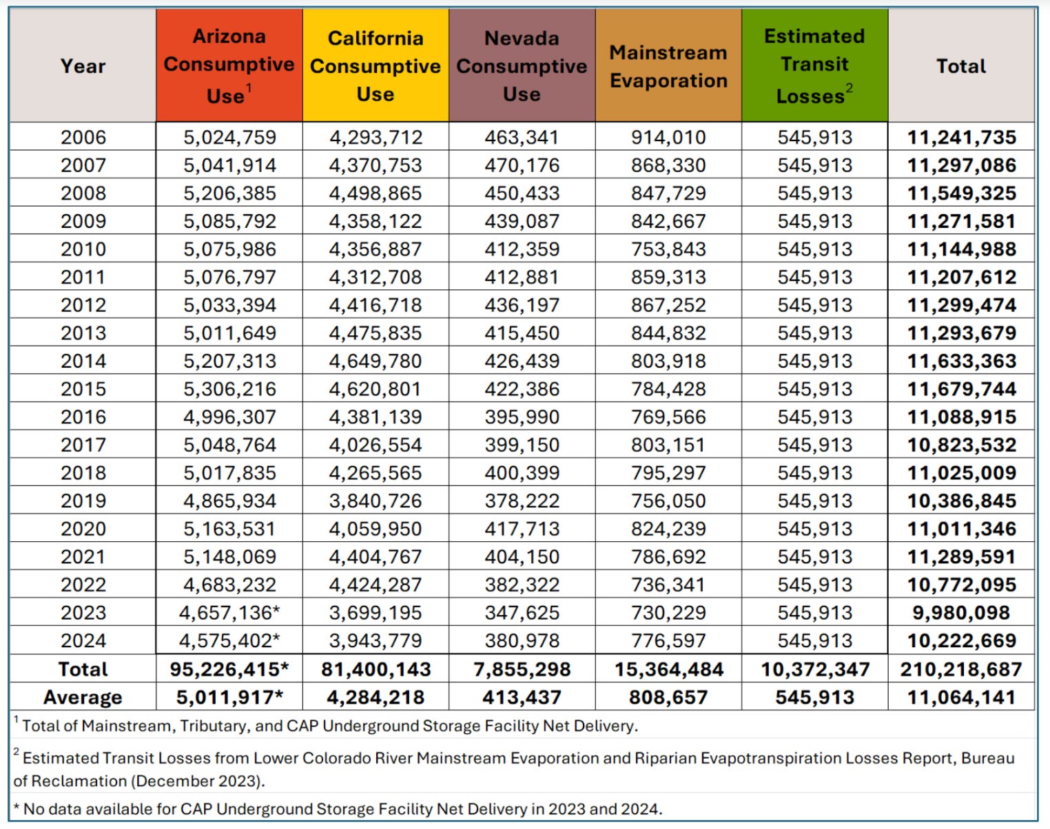
Arizona is understandably displeased because they would take the greatest hit under any alternative. This is not because they are somehow inferior, but because the water rights to the Central Arizona Project, which delivers Colorado River water to Phoenix and Tucson, are junior to most other big users in the Lower Basin. “… each alternative, though broad in scope, will translate in practice specifically as drastic reductions to Arizona’s water supply.”
“We are deeply troubled that Reclamation all but abandons its increasingly critical role in ensuring the Upper Basin States fulfill their delivery obligations under the Colorado River Compact of 1922 (Compact).” This refers to the non-depletion or minimum-delivery obligation that I’ve written about before.
“The DEIS itself acknowledges that ‘widespread impacts on social and economic conditions may also be possible,’ including circumstances in which municipalities may need to pursue alternative or even hauled water sources to maintain basic services. Drastic cuts could have cascading consequences for human health and safety and destabilize the lives and livelihoods of Arizonans, tribal communities, and critical industries that rely on Colorado River supplies.”
They say the cuts will damage the state’s agriculture, manufacturing, and aerospace industries and that it will put at risk: “… the largest concentration of advanced semiconductor manufacturing investment in the country, representing roughly $200 billion in announced projects since 2020.” Semiconductor production is extremely water-intensive, with the average factory consuming up to 10 million gallons of ultra-pure water daily.
They call on any plans to “include verifiable Upper Basin conservation measures commensurate with Lower Basin conservation measures, including identifying tangible metrics that demonstrate Upper Basin water conservation.”
“We believe that Reclamation must institute bold and meaningful changes but that those changes must be implemented in a manner that is consistent with the 1922 Colorado River Compact, the 1944 binational treaty with Mexico, the 1948 Upper Basin Compact, and the other foundational elements of the Law of the River.”
“Reclamation must prioritize hydrologic reality over predictability for Lower Basin users. The Draft EIS places undue emphasis on predictability1 for water users, a goal that is unattainable under future climate conditions unless system storage is replenished and overall demands are permanently reduced to match the supply.”
“… several alternatives include Upper Basin water conservation ranging from zero to 500,000 acre-feet annually … <but> … fails to analyze the environmental or socioeconomic impacts associated with these conservation volumes.” It adds that a 200,000 acre-feet reduction in the Upper Basin would require fallowing 52,000 acres on the Western Slope.
“Lower Basin water use must be reduced by 1.5 million acre-feet at all times, regardless of the alternative. This amount represents system losses (i.e., transit losses and reservoir evaporation) and should not be classified as shortage.” This is a longstanding issue. Reservoir evaporation and other such losses are counted against the Upper Basin’s consumptive use, in part because of the non-depletion obligation. The same is not true for the Lower Basin; when they say they use 7.5 million acre-feet, that does not include evaporation or seepage or other system losses, only what they pull out of the river.
“The range of alternatives must include option(s) that perform under critically dry hydrology. Currently, none of the alternatives in the Draft EIS perform under critically dry hydrology. At least one alternative must protect critical infrastructure and respond effectively to significantly lower river flows than historically observed.” We are approaching a critically dry situation this summer, when the feds will have to decide whether and how to keep Lake Powell from dropping below minimum power pool. So far there is no plan for this.
“Hydrology must drive Post-2026 operations. Operating guidelines based upon comparative reservoir elevations which do not factor in real time hydrology have been disastrous for protecting storage in Lake Powell and thus, have failed to provide the water supply certainty for the Upper Basin intended by the Law of the River …”
“Interbasin transactions must not be allowed in the proposed action.” That is, Upper Basin users with senior rights should not be able to sell their water to Lower Basin users.
The team of Anne Castle, John Fleck, Eric Kuhn, Jack Schmidt, Katherine Tara, and Kathryn Soren, river experts and academics who aren’t representing any specific water user, state, or basin, also weighed in. Their comments, as Fleck put it in his Inkstain blog, could be summed up as: “Tell us what you’re going to do.” And, also:
The group calls on Interior to “primarily focus on the Dry and Critically Dry scenarios. … We think it important to be mindful of the underlying year-to-year hydrology of the 21st century as we look to the future. … we are struck by the fact that 50% of the individual years of the 21st century have been Dry or Critically Dry, and only 27% of the years (including 2017, 2019, 2023) have been Moderately Wet or Wet.”
“We suggest that the DEIS include a description of an alternative that performs sufficiently well during Dry scenarios and an alternative that performs sufficiently well during Critically Dry scenarios.”
“ … it is imperative that Reclamation provide a clear picture of what actions will be implemented in the near term (i.e., next year, next 3 years, next 5 years) to protect critical infrastructure, and to protect public health and safety.”
Noting that lawsuits are inevitable regardless of which alternative the feds choose, they urge them to avoid “safe” options and go with a plan with “… the broadest possible interpretation of Reclamation’s and Interior’s authority to provide a predictable and resilient Colorado River so that the system can continue to operate in a reasonable manner while the lawsuits proceed.”
Call on the feds to “… explore these areas for possible inclusion in the preferred alternative:
Reduction of deliveries in the Lower Basin in excess of 1.48 MAF when insufficient water is available for release.
Provision for releases of water from the Colorado River Storage Project initial units as necessary to protect critical elevations in Lake Powell and ensure continued Upper Basin Compact compliance.
Operation of federal projects in the Upper Basin to store or use less water during critical periods.
Continuation, expansion, and modification of Assigned Water programs (such as Intentionally Created Surplus and Mexican Water Reserve) with improvements to ensure operational neutrality and minimize adverse impact to priority water.
Establishing a conservation pool in Lake Powell for storing Upper Basin conserved water to be utilized for Compact compliance purposes. For more on conservation pools, check out the Shannon Mulane’s explainer in the Colorado Sun.
The group finds fault with the plan for not addressing “the need for enforceable reductions in the Upper Basin.” They go with the Lower Basin’s interpretation of the non-depletion/minimum-delivery obligation, saying that the Colorado River Compact does not guarantee that the Upper Basin gets half of the water in the river. Plus, they point out that the plan’s demand forecasts for the Upper Basin are unrealistically high, putting more of the burden for cuts on the Lower Basin.
The Southern Nevada Water Authority and Colorado River Commission of Nevadaare especially critical, writing:
“Since the onset of drought in 2002, <Nevada water users> have reduced their overall Colorado River water consumption by more than 40 percent even as our population grew by more than 875,000 people. And they, unlike so many others, have not ignored the reality facing the basin by making the flimsy argument that our economy cannot prosper while water consumption decreases.”
Like Arizona, they bring up the minimum-delivery/non-depletion clause of the Colorado River Compact and call on the Upper Basin to comply with it.
Interior’s “… approach to protecting the Glen Canyon Dam river outlet works by reducing releases from Lake Powell—rather than making infrastructure repairs and improvements—is shortsighted and harms Nevada and the Lower Basin States.”
The Upper Colorado River Commissionemphasizes the Lower Basin’s history of exceeding its Colorado River Compact allocation and failing to account for evaporation and other system losses. Colorado’s Upper Colorado River CommissionerBecky Mitchell submitted similar, very detailed comments that emphasized the Colorado River Compact’s equitable division of the river between the Upper Basin and Lower Basin. She points out that the Lower Basin’s interpretation of the minimum-delivery/non-depletion clause contradicts and even negates that division.
📖 Reading (and watching) Room 🧐
Must read: Teal Lehto’s and Len Necefer’s speculative fiction take on what might happen on the Colorado River, and to the people who rely on it, in 2030 if current climatic trends continue. It’s dramatic and sensational and catastrophic, but it’s also very well informed, smart, and not at all far-fetched, in my humble opinion.
City Council approved a $44,000 feasibility study last week that will explore where a new surf wave could be optimally built along the Animas River in Durango. The nonprofit Animas River Surfers proposed the feasibility study and a partnership with the city to get it done. It raised $13,000 to contribute to the study. The city budgeted $40,000 plus a 10% contingency from the 2015 sales tax fund for the study, which City Council approved last week along with budget appropriations for a wide scope of other projects. Parks and Recreation Director Scott McClain said it has received proposals for the study, and the chosen consultant will identify possible locations for a surf wave and narrow them down to one. The consultant will engage with commercial organizations and Animas River users during the study…City spokesman Tom Sluis told The Durango Herald the city hasn’t yet hired a consultant to conduct the feasibility study and it will be another week or so before a consultant is selected.
All it takes is a quick step outside to confirm that, so far, winter in La Plata County – and across much of Southwest Colorado – is unseasonably warm. Durango set record-breaking highs on Dec. 24 and Dec. 25, when the temperature climbed to 60 degrees, 5 degrees warmer than previous records for those dates, according to in-town data from the National Weather Service. The warm temperatures have been accompanied by a drier-than-normal December and scarce early season snowfall. While it has impacted and raised concerns across sectors like cattle ranchers, water management and tourism – sectors largely dependent on winter weather – no one is throwing out hope for a good winter. [ed. emphasis mine]
Local businesses have been impacted by the weather differently – good or bad, dependent on the seasonal recreation it sells. Scant snowfall is bad news for powder hounds, and bad business for ski shops that depend on winter recreation business…And while ski-related businesses wait for snow, Durango’s fishing industry has seen increased activity, as warmer temperatures keep rivers accessible later into the season…If warm, dry conditions persist long-term, Glenn said, the outlook could shift. Low river levels and heightened wildfire risk would pose serious challenges for the fishing industry in future seasons…
For the region’s ranching community, winter precipitation is closely tied to long-term water security. Low snowpack can mean less water available once irrigation ditches reopen in the spring. Although the warm weather has limited snowfall so far, heavy rains in the fall helped replenish local reservoirs, providing some reassurance heading into summer, said Wayne Jefferies, president of the Archuleta Cattlemen’s Society…Lemon and Vallecito reservoirs are now nearly three-quarters full – a significant improvement from projections at the end of last summer…
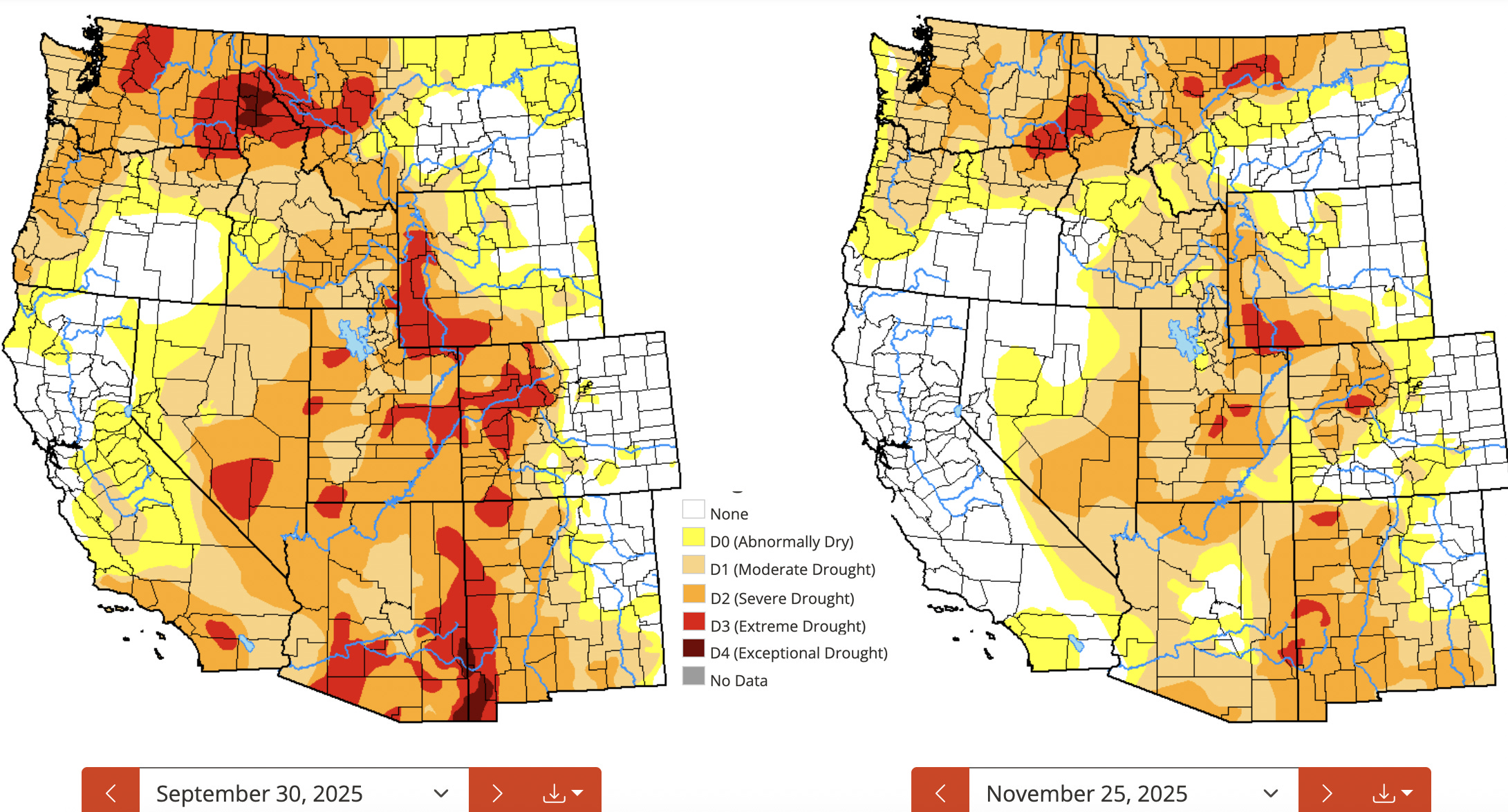
Colorado Drought Monitor map December 30, 2025.
Still, Jefferies said a lack of snowfall remains concerning. If dry conditions persist into early 2026, reservoir levels alone may not be enough to offset reduced snowmelt. Ranchers – who often joke that they are “grass farmers” – rely heavily on snowmelt to recharge underground moisture that supports healthy forage growth. Beneath the surface, soil and gravel layers act like a sponge, [Wayne] Jefferies said. Snowmelt is needed to saturate that sponge before irrigation water and rain can effectively reach grasses. Without sufficient snow and spring runoff, those underground layers remain dry, he said. When irrigation begins, much of the water is absorbed below ground, leaving less available for grasses to grow. The result can be weaker forage, reduced grazing capacity and added strain on ranching operations. Jefferies added this isn’t new. Southwest Colorado has experienced persistent drought conditions for much of the past two decades, punctuated by only brief periods of relief…
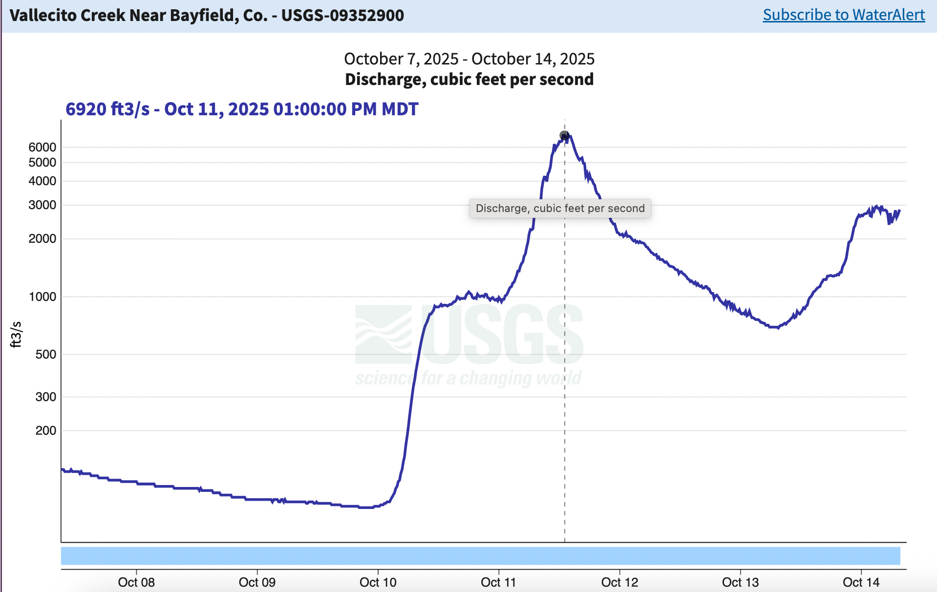
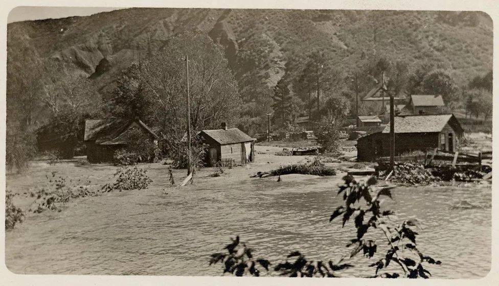
Water managers, meanwhile, are entering winter in a stronger position than usual thanks to the fall floods. The October flooding caused reservoirs to rise rapidly. Vallecito Reservoir, which stores water for the Pine River Irrigation District, rose 25 feet in just a few days, said Ken Beck, PRID superintendent. The surplus of water reserves after a dry summer is a good buffer for next year, and has eased the stress of relying solely on winter precipitation, Beck said, although water supply is always subject to some degree of uncertainty.
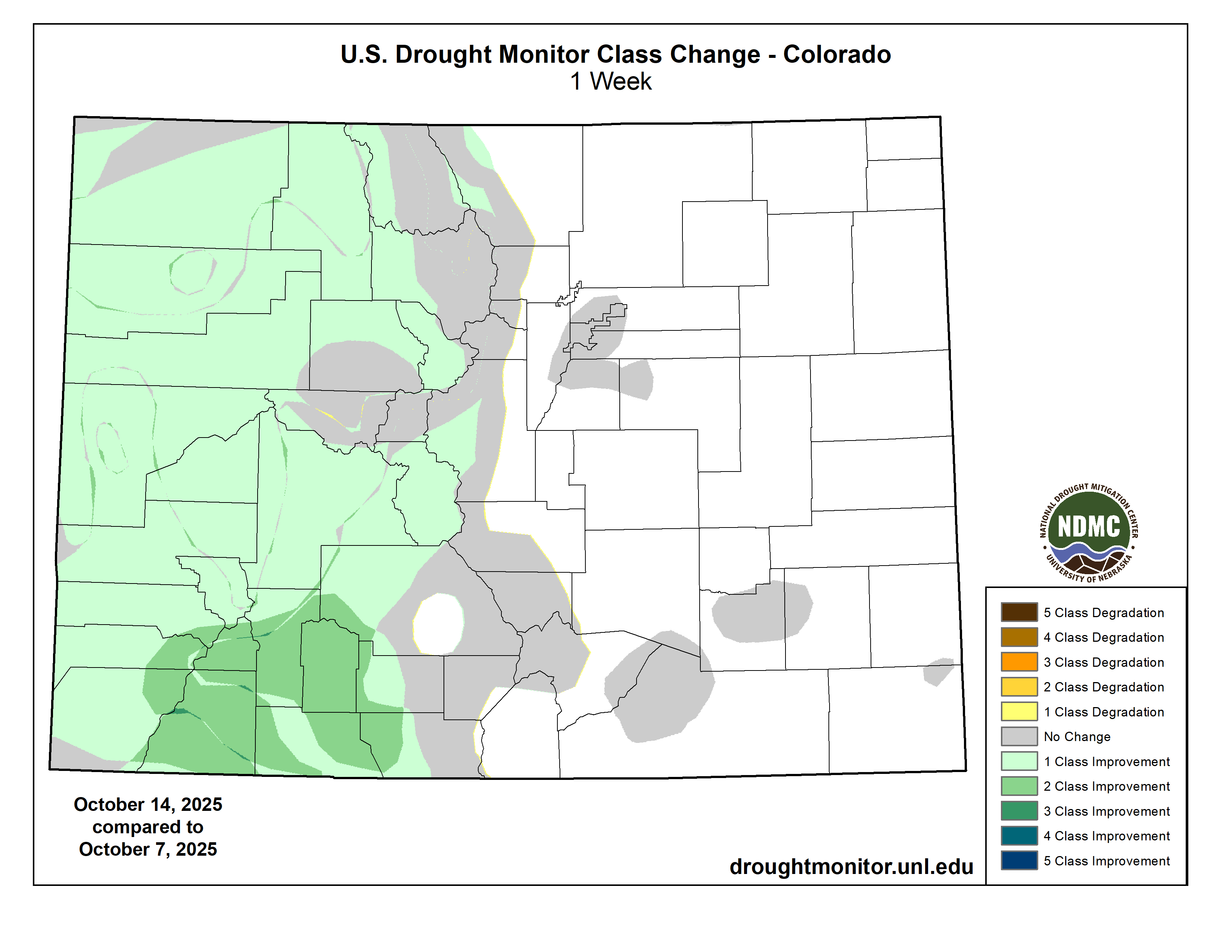
The drought situation has improved markedly in the Southwest since the end of the last water year, especially in the Four Corners area. Source: National Drought Monitor.
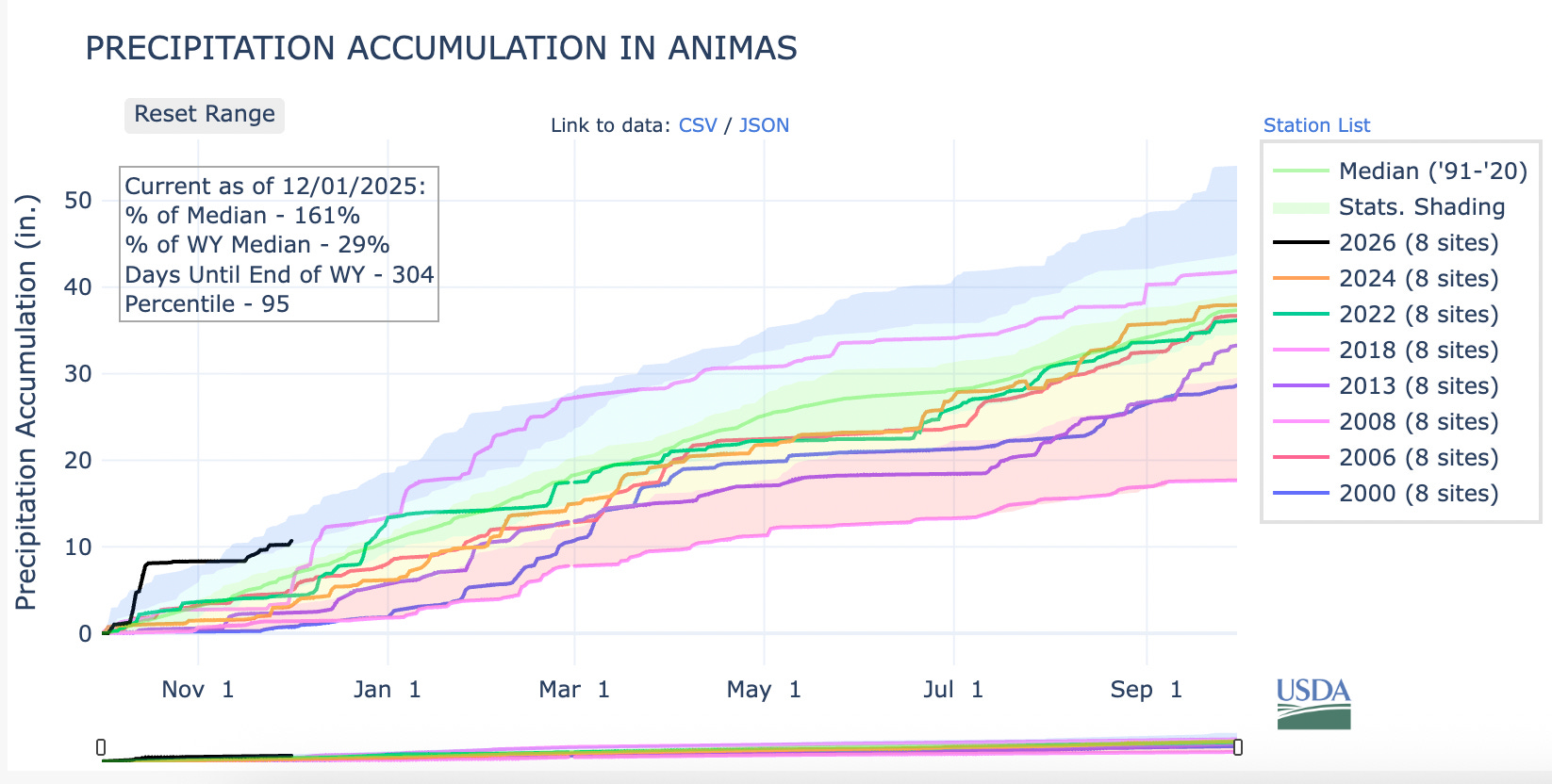
We are now two months into the water year — and a couple of days into meteorological winter — and so far both are pretty weird. On the one hand, much of the West is covered by one of the scantest snowpacks for early December in decades. On the other, it’s also been one of the wettest beginnings to the water year in recent memory.
Graph of 2026 water year snowpack levels for the Animas River watershed (which this year reflects that for most of western Colorado and the Upper Colorado River Basin), along with every year since 2000 that has started as sparsely or more so than this year. Note that the 2008 snowpack in the Animas was just as meagre in early December as it is this year. Then the snows came with a vengeance, leading to one of the biggest winters on record as well as a very healthy spring runoff that lasted well into July.
While snow levels are paltry, the weather gods have delivered plenty of precipitation to the region. While that has helped ease drought conditions, it is no substitute for a healthy snowpack.
Adding to the uncanniness has been the wave of generous storms that have dumped up to a foot of snow on Colorado ski areas and snarled traffic, leading to at least two multi-car pileups on I-70 and shutting down other arteries — yet still failing to bring snowpack levels to anywhere near “normal.”
It’s a big ol’ mixed bag, in other words. The big October deluges eased the drought in much of the region, but the warm temperatures and snow drought don’t bode well for next spring’s runoff. Meagre early winter snowpacks can make and have made dramatic comebacks (e.g. water year 2008 in southwestern Colorado), and another storm is moving into the region as I write this, yet the National Weather Service’s is predicting an abnormally warm and dry winter for much of the Southwest.
🌵 Public Lands 🌲
The Grand County commissioners’ “Access and Capacity Enhancement Alternative” plan aimed at increasing visitation at Arches National Park was just the tip of an iceberg, it seems. Yesterday (Dec. 1), Commissioner Brian Martinez presented the plan to a group of state and federal officials at a closed State of Utah and National Park Service Workshop in Salt Lake City.
The meeting’s purpose, according to the official agenda, is:
This may sound fairly innocuous (and maybe it is). But given some of the players, it may also be the latest volley in Utah’s long-running effort to seize control of public lands. The meeting was run by the Interior Department’s associate deputy secretary, Karen Budd-Falen, and Redge Johnson, who leads Utah’s Public Lands Policy Coordinating Office.
Budd-Falen built her legal career on fighting federal agencies, including the Interior Department, and was part of the Sagebrush Rebellion and the Wise Use movements that endeavored to turn federal land over to states and counties and to weaken regulations on the extractive industries. Johnson, meanwhile, was a driving force behind the state’s effort to take control of 18.5 million acres of Bureau of Land Management land in the state.
An anti-BLM sticker (referring, presumably, to the federal land agency, not the Black Lives Matter movement) at another Phil Lyman rally against “federal overreach” and motorized travel closures in southeastern Utah back in 2014. Photo credit: Jonathan P. Thompson/The Land Desk
It’s not clear what is meant when they say the meeting is aimed at achieving Trump’s agenda. As far as national parks go, the administration has been rather chaotic: Freezing hiring, laying off thousands of staff (only to rehire some of them), slashing budgets, and allowing visitors to run roughshod over the parks during the government shutdown.
It sure looks like they are trying to cause the parks to fail, which would give them an excuse to further privatize their functions. Private for-profit corporations already run the lodges, campgrounds, and other services inside many parks. That’s why, during the shutdown, concessionaire-run campgrounds within parks continued to operate, while all of the government-run functions, such as entrance-fee-collection, were shuttered. In this way a false contrast was created between the functional privately-run operations and the dysfunctional public ones; visitors during that time would be excused for preferring the former.
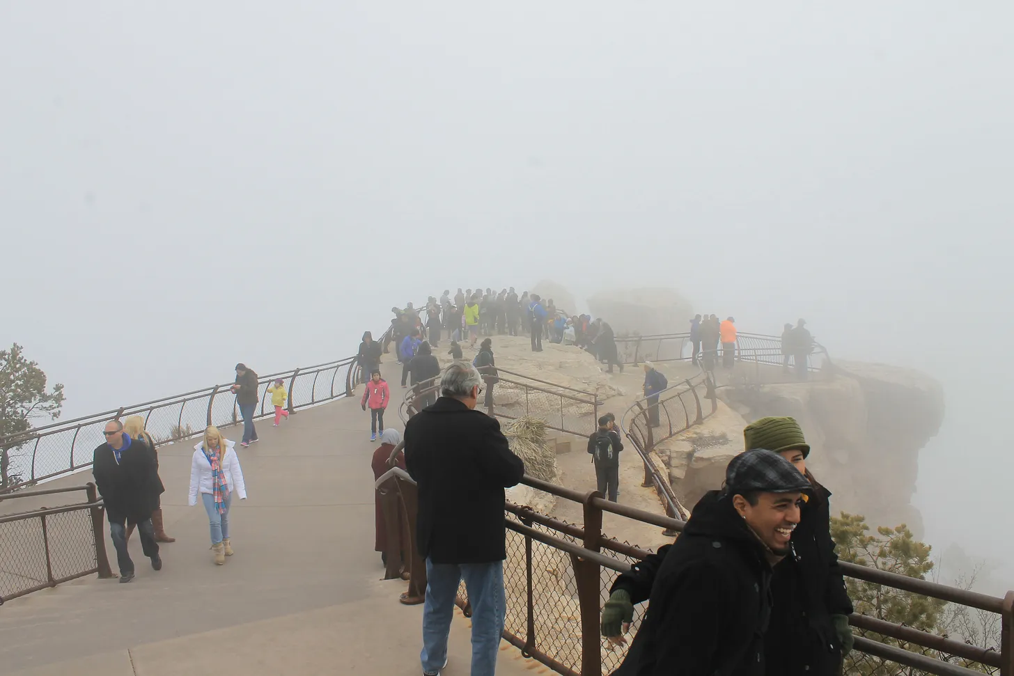
The timing of this meeting, purportedly to receive input from gateway communities, is kind of odd. I have to wonder whether the Interior Department consulted local elected officials before raising entry fees for foreign visitors to $100 at Zion and Bryce Canyon National Parks in Utah, along with Grand Canyon, Acadia, Everglades, Glacier, Grand Teton, Rocky Mountain, Sequoia & Kings Canyon, Yellowstone, and Yosemite National Parks.
The Southwest’s tourism industry is highly reliant on international visitors. Visitation from abroad is already down, thanks mostly to the Trump administration’s “America First” creed and its general hostility to the rest of the world. Singling out foreign travelers for these higher fees — even if only at the most popular parks — is likely to dampen visitation from abroad even more, which will ripple through Western economies.
Grand County’s bid to cram even more visitors into Arches National Park won’t be too effective if would be visitors don’t even make it to the United States …
🗺️ Messing with Maps 🧭
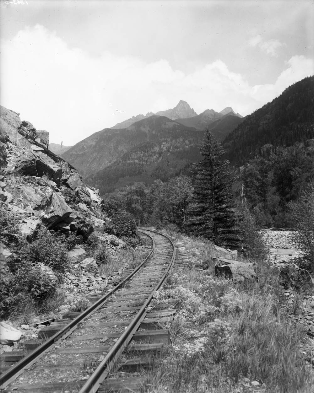
This is just another old map that caught my attention, in part because it’s a reminder of how extensive the railroad network was, even in the rugged parts of Colorado, back in the late 1800s and early 1900s. This one shows the Denver & Rio Grande rail lines in 1893.
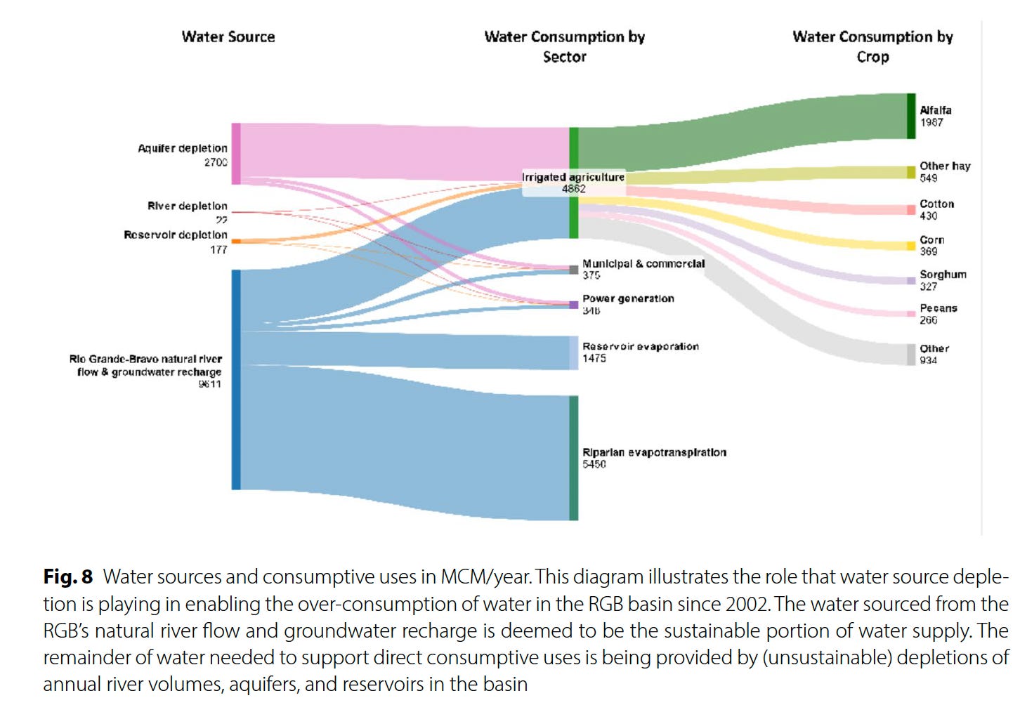
The Colorado River and its woes tend to get all of the attention, but the Southwest’s “other” big river, the Rio Grande, is in even worse shape thanks to a combination of warming temperatures, drought, and overconsumption. That’s become starkly evident in recent years, as the river bed has tended to dry up earlier in the summer and in places where it previously had continued to carry at least some water. Now Brian Richter and his team of researchers have quantified the Rio Grande’s slow demise, and the conclusions they reach are both grim and urgent: Without immediate and substantial cuts in consumption, the river will continue to dry up — as will the farms and, ultimately, the cities that rely on it.
The Rio Grande’s problems are not new. Beginning in the late 1800s, diversions for irrigation in the San Luis Valley — which the river runs through after cascading down from its headwaters in the San Juan Mountains — sometimes left the riverbed “wholly dry,” wrote ichthyologist David Starr Jordan in 1889, “all the water being turned into these ditches. … In some valleys, as in the San Luis, in the dry season there is scarcely a drop of water in the riverbed that has not from one to ten times flowed over some field, while the beds of many considerable streams (Rio la Jara, Rio Alamosa, etc.) are filled with dry clay and dust.”
San Luis Valley farmers gradually began irrigating with pumped groundwater, allowing them to rely less on the ditches (but causing its own problems), and the 1938 Rio Grande Compact forced them to leave more water in the river. While that kept the water flowing through northern and central New Mexico, the Rio Grande’s lower reaches still occasionally dried up.
Then, in the early 2000s, the megadrought — or perhaps permanent aridification — that still plagues the region settled in over the Southwest. [ed. emphasis mine] Snowpack levels in the river’s headwaters shrank, both due to diminishing precipitation and climate change-driven warmer temperatures, which led to runoff and streamflows 17% lower than the 20th century average, according to the new study. And yet, overall consumption has not decreased.
“In recent decades,” the authors write, “river drying has expanded to previously perennial stretches in New Mexico and the Big Bend region. Today, only 15% of the estimated natural flow of the river remains at Anzalduas, Mexico near the river’s delta at the Gulf of Mexico.” Reservoirs, the river’s savings accounts, have been severely drained to the point that they won’t be able to withstand another one or two dry winters. As farmers and other users have increasingly turned to groundwater pumping, aquifers have also been depleted. The situation is clearly unsustainable.
Something’s gotta give on the Rio Grande, and while we may be tempted to target Albuquerque’s sprawl, drying up all of the cities and power plants that rely on the river wouldn’t achieve the necessary cuts.
Source: “Overconsumption gravely threatens water security in the binational Rio Grande-Bravo basin” by Brian Richter et al.
It will come as little surprise to Western water watchers that agriculture is by far the largest water user on the Rio Grande — taking up 87% of direct human consumption — and that alfalfa and other hay crops gulp up the lion’s share, or 52%, of agriculture’s slice of the river pie. This isn’t necessarily because alfalfa and other hays are thirstier than other crops, but because they are so prevalent, covering about 433,000 acres over the entire basin, more than four times as much acreage as cotton.
Source: Overconsumption gravely threatens water security in the binational Rio Grande-Bravo basin
This kind of math means farmers are going to have to bear the brunt of the necessary consumption cuts — either voluntarily or otherwise. In fact, they already have: Between 2000 and 2019, according to the report, Colorado lost 18% of its Rio Grande Basin farmland, New Mexico lost 28%, and the Pecos River sub-basin lost 49% (resulting in a downward trend in agricultural water consumption). Some of this loss was likely incentivized through conservation programs that pay farmers to fallow their fields. But it was also due to financial struggles.
Yet even when farmers are paid a fair price to fallow their fields there can be nasty side effects. Noxious weeds can colonize the soil and spread to neighbors’ farms, it can dry out and mobilize dust that diminishes air quality and the mountain snowpack, and it leaves holes in the cultural fabric of an agriculture-dependent community. If a field’s going to be dried up, it should at least be covered with solar panels.
Another possibility is to switch to crops that use less water. This isn’t easy: Farmers grow alfalfa in the desert because it’s actually quite drought tolerant, doesn’t need to be replanted every year, is less labor-intensive than other crops, is marketable and ships relatively easy, and can grow in all sorts of climates, from the chilly San Luis Valley to the scorching deserts of southern Arizona.
Still, it can be done, as a group of farmers in the San Luis Valley are demonstrating with the Rye Resurgence Project. This effort is not only growing the grain — which uses less water than alfalfa, is good for soil health, and makes good bread and whiskey — but it is also working to create a larger market for it. While it’s only a drop in the bucket, so to speak, this is the sort of effort that, replicated many times across the region, could help balance supply and demand on the river, without putting a bunch of farmers out of business.
Photo credit: The Rye Resurgence Project
***
Oh, and about that other river? You know, the Colorado? Representatives from the seven states failed to come up with a deal on how to manage the river by the Nov. 15 deadline. The feds had mercy on them, giving them until February to sort it all out. I’m not so optimistic, but we’ll see. Personally, I think the only way this will ever work out is if the Colorado River Compact — heck, the entire Law of the River — is scrapped, and the states and the whole process is started from scratch, this time with a much better understanding of exactly how much water is in the river, and with the tribal nations having seats at the table.
⛏️ Mining Monitor ⛏️
There are a bunch of wannabe uranium mining companies out there right now, locating claims and acquiring and selling claims and touting their exploratory drilling results. But there are only a small handful of firms that are actually doing anything resembling mining. One of them is the Canada-based Anfield, which just broke ground on its Velvet-Wood uranium mine in the Lisbon Valley, even without all of the necessary state permits.
Now Anfield says it has applied for a Colorado permit to restart its long-idle JD-8uranium mine. The mine is on one of a cluster of Department of Energy leases overlooking the Paradox Valley from its southern slopes, and was previously owned and operated by Cotter Corporation. The mine has not produced ore since at least 2006. Anfield says it will process the ore at its Shootaring Mill near Ticaboo, Utah, which has yet to get Utah’s green light.
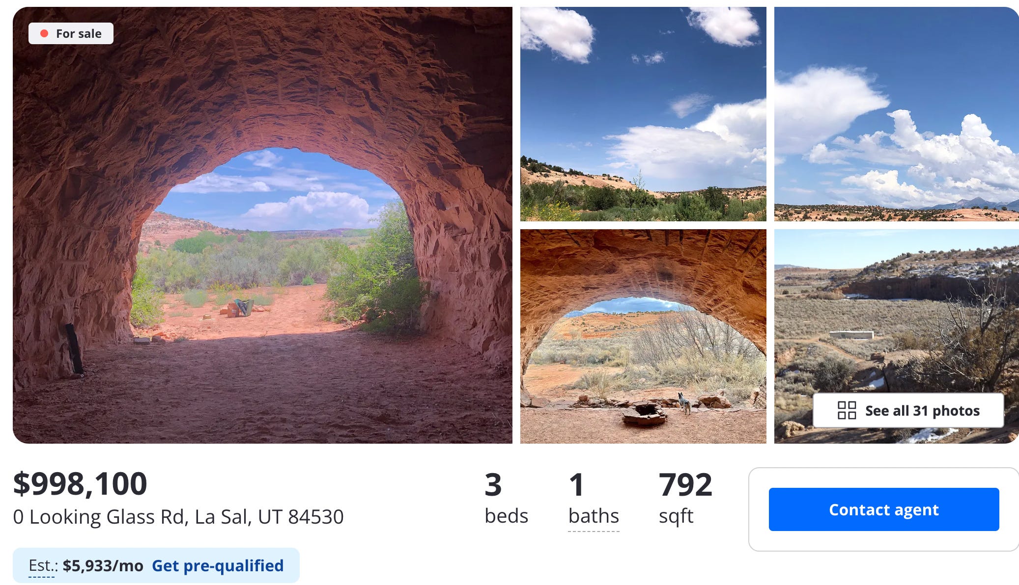
🏠 Random Real Estate Room 🤑
Look! Affordable housing near Moab! Sure, it’s a cave, but it’s only $99,000. Oh, what’s that? $998,000? They’re selling a cave for a million buckaroos? But of course they are. To be fair, it’s not just a cave. It’s several of them, plus a trailer. Crazy stuff.
📸 Parting Shot 🎞️
A work train in the Animas River gorge just below Silverton. Jonathan P. Thompson photo.
Rio Grande and Pecos River basins. Map credit: By Kmusser – Own work, Elevation data from SRTM, drainage basin from GTOPO [1], U.S. stream from the National Atlas [2], all other features from Vector Map., CC BY-SA 3.0, https://commons.wikimedia.org/w/index.php?curid=11218868
Until the passage of the Comprehensive Environmental Response, Compensation, and Liability Act (CERCLA) in 1980, miners across the American West extracted gold, silver, and other valuable “hardrock” minerals—and then simply walked away. Today, tens of thousands of these abandoned hardrock mines continue to leak acidic, metal-laden water into pristine streams and wetlands. Federal agencies estimate that over a hundred thousand miles of streams are impaired by mining waste. Nearly half of Western headwater streams are likely contaminated by legacy operations. Despite billions already spent on cleanup at the most hazardous sites, the total cleanup costs remaining may exceed fifty billion dollars.
So how did we end up here? In short, the General Mining Law of 1872 created a lack of accountability for historic mine operators to remediate their operations, but CERCLA and the Clean Water Act (CWA) arguably add an excess of accountability for third parties trying to clean up abandoned mines today.
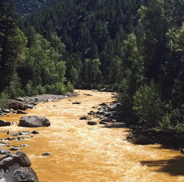
The Animas River running orange through Durango after the Gold King Mine spill August 2015. Photo credit: Jonathan P. Thompson/The Land Desk
The first legislation to address this problem was introduced in 1999. Many iterations followed and failed, even in the wake of shocking images and costly litigation due to the Gold King Mine spill that dyed the Animas River a vibrant orange in 2015. Finally, in December, 2024, Congress passed the Good Samaritan Remediation of Abandoned Hardrock Mines Act of 2024 (GSA).
The GSA is a cautious, bipartisan attempt to empower volunteers to clean up this toxic legacy. The law creates a short pilot program and releases certain “Good Samaritans” from liability under CERCLA and the CWA, which has long deterred cleanup by groups like state agencies and NGOs. EPA has oversight of the program and the authority to issue permits to Good Samaritans for the proposed cleanup work.
Despite the promise of this new legislation, critical questions remain unanswered about the GSA and how it will work. Only time will tell whether EPA designs and implements an effective permitting program that ensures Good Samaritans complete remediation work safely and effectively. EPA now has the opportunity as the agency that oversees this program to unlock the promise of the GSA.
The GSA left some significant gaps unanswered in how the pilot program will be designed and directed EPA to issue either regulations or guidance to fill in those gaps. EPA missed the statutory deadline to start the rulemaking process (July, 2025) and is now working to issue guidance on how the program will move forward. EPA must provide a 30-day public comment period before finalizing the guidance document according to the GSA. With EPA’s hopes of getting multiple projects approved and shovels in the ground in 2026, the forthcoming guidance is expected to be released soon. While we wait, it’s worth both looking back at what led to the GSA and looking ahead to questions remaining about the implementation of the pilot program.
A Century of Mining the West Without Accountability
The story begins with the General Mining Law of 1872, a relic of the American frontier era that still governs hardrock mining on federal public lands. The law allows citizens and even foreign-based corporations to claim mineral rights and extract valuable ores without paying any federal royalty. Unlike coal, oil, or gas—which fund reclamation through production fees—hardrock mining remains royalty-free.
As mining industrialized during the 20th century, large corporations replaced prospectors. Until 1980, mines were often abandoned without consequences or cleanup once they became unprofitable. The result: an estimated half-million abandoned mine features will continually leach pollution into American watersheds for centuries.
CERLCA Liability Holds Back Many Abandoned Mine Cleanups
Congress sought to address toxic sites through CERCLA, also known as the Superfund law, which makes owners and operators strictly liable for hazardous releases. In theory, that ensures accountability. In practice, it creates a paradox: if no polluter can be found at an abandoned site, anyone who tries to clean up the mess may be held responsible for all past, present, and future pollution.
The Clean Water Act’s Double-Edged Sword
Even state agencies, tribes, or nonprofits that treat contaminated water risk being deemed “operators” of a hazardous facility. That fear of liability—combined with enormous costs—has frozen many potential Good Samaritans in place. Federal efforts to ease this fear have offered little more than reassurance letters without real protection.
The Clean Water Act compounds the problem. Anyone who discharges pollution into a surface water via any discernible, confined and discrete conveyance must hold a point source discharge permit. By requiring these permits and providing for direct citizen enforcement in the form of citizen suits, the CWA has led to significant improvements in water quality across the country. That said, courts have ruled that drainage pipes or diversion channels used to manage runoff from abandoned mines may also qualify as point sources. As a result, Good Samaritans who exercise control over historic point sources, like mine tunnels, could face penalties and other liabilities for unpermitted discharges, even when they improve overall conditions.
The 2024 Good Samaritan Act Steps onto the Scene
After decades of failed attempts, the Good Samaritan Remediation of Abandoned Hardrock Mines Act was signed into law in December, 2024. The GSA authorizes EPA to create a pilot program, issuing up to fifteen permits for low-risk cleanup projects over seven years. Most importantly, permit holders receive protection from Superfund and Clean Water Act liability for their permitted activities. This legal shield removes one of the greatest barriers to cleanup efforts.
Applicants can seek either a Good Samaritan permit to begin active remediation or an investigative sampling permit to scope out a site for potential conversion to a Good Samaritan permit down the road.
In either case, applicants must show:
they had no role in causing, and have never exercised control over, the pollution in their application,
they possess the necessary expertise and adequate funding for all contingencies within their control, and
they are targeting low-risk sites, which are generally understood to be those that require passive treatment methods like moving piles of mine waste away from streams or snowmelt or diverting water polluted with heavy metals below mine tailings toward wetlands that may settle and naturally improve water quality over time
Under the unique provisions of the GSA, each qualifying permit must go through a modified and streamlined National Environmental Policy Act (NEPA) review process. EPA or another lead agency must analyze the proposed permit pursuant to an Environmental Assessment (EA). If the lead agency cannot issue a Finding of No Significant Impact (FONSI) after preparing an EA, the permit cannot be issued. The GSA therefore precludes issuance of a permit where the permitted activities may have a significant impact on the environment.
The pilot program only allows for up to fifteen low risk projects that must be approved by EPA over the next seven years. Defining which remediations are sufficiently low-risk becomes critical in determining what the pilot program can prove about the Good Samaritan model for abandoned mine cleanup. To some extent, “low risk” is simply equivalent to a FONSI. But the GSA further defines the low-risk remediation under these pilot permits as “any action to remove, treat, or contain historic mine residue to prevent, minimize, or reduce (i) the release or threat of release of a hazardous substance, pollutant, or contaminant that would harm human health or the environment; or (ii) a migration or discharge of a hazardous substance, pollutant, or contaminant that would harm human health or the environment.”
This excludes “any action that requires plugging, opening, or otherwise altering the portal or adit of the abandoned hardrock mine site…”, such as what led to the Gold King mine disaster. Many active treatment methods are also excluded from the pilot program, therefore, because they often involve opening or plugging adits or other openings to pump out water and treat it in a water treatment plant, either on or off-site. As a result, the Good Sam Act’s low-risk pilot projects focus on passive treatment of the hazardous mine waste or the toxic discharge coming off that waste, such as a diversion of contaminated water into a settlement pond.
The GSA requires that permitted actions partially or completely remediate the historic mine residue at a site. The Administrator of EPA has the discretion to determine whether the permit makes “measurable progress”. Every activity that the Good Samaritan and involved permitted parties take must be designed to “improve or enhance water quality or site-specific soil or sediment quality relevant to the historic mine residue addressed by the remediation plan, including making measurable progress toward achieving applicable water quality standards,” or otherwise protect human health and the environment by preventing the threat of discharge to water, sediment, or soil. The proposed remediation need not achieve the stringent numeric standards required by CERCLA or the CWA.
Furthermore, it can be challenging to determine the discrete difference between the baseline conditions downstream of an acid mine drainage prior to and after a Good Samaritan remediation is completed. Not only do background conditions confuse the picture, but other sources of pollution near the selected project may also make measuring water quality difficult. This may mean that the discretion left to the EPA Administrator to determine “measurable progress” becomes generously applied.
Finally, once EPA grants a permit, the Good Samaritan must follow the terms, conditions, and limitations of the permit. If the Good Samaritan’s work degrades the environment from the baseline conditions, leading to “measurably worse” conditions, EPA must notify and require that the Good Samaritantake “reasonable measures” to correct the surface water quality or other environmental conditions to the baseline. If these efforts do not result in a “measurably adverse impact”, EPA cannot consider this a permit violation or noncompliance. However, if Good Samaritans do not take reasonable measures or if their noncompliance causes a measurable adverse impact, the Good Samaritan must notify all potential impacted parties. If severe enough, EPA has discretion to revoke CERCLA and CWA liability protections.
Recently, EPA shared the following draft flowchart for the permitting process:
Disclaimer: This is being provided as information only and does not impose legally binding requirements on EPA, States, or the public. This cannot be relied upon to create any rights enforceable by any party in litigation with the United States. Any decisions regarding a particular permit will be made based upon the statute and the discretion granted by the statute, including whether or not to grant or deny a permit.
Challenges Facing the Pilot Program Implementation
Despite its promise, the pilot program’s scope is limited. With only fifteen Good Samaritan permits eligible nationwide and no dedicated funding, the law depends on states, tribes, and nonprofits to provide their own resources. The only guidance issued so far by EPA detailed the financial assurance requirements that would-be Good Samaritans must provide to EPA to receive a permit. Definitions provided in this financial assurance guidance raised concerns for mining trade organizations and nonprofits alike with EPA’s proposed interpretations of key terms including “low risk” and “long-term monitoring”. Crucial terms like these, along with terms impacting enforcement when a permitted remediation action goes awry, like “baseline conditions”, “measurably worse”, and “reasonable measures” to restore baseline conditions, are vague in the GSA. How EPA ultimately clarifies terms like these will play a large role in the success of the GSA in its ultimate goal: to prove that Good Samaritans can effectively and safely clean up abandoned hardrock mine sites. The soon-to-be-released guidance document will therefore be a critical moment in the history of this new program.
Funding the Future
Funding remains the greatest barrier to large-scale remediation efforts. Coal mine cleanups are funded through fees on current production under the Surface Mining Control and Reclamation Act. Current hardrock mining, however, still pays no federal royalty. A modernized system could pair Good Samaritan permitting with industry-funded reclamation fees, ensuring that those profiting from today’s mining help repair the past. Without this reform, the burden will remain on underfunded agencies and nonprofits. However, this General Mining Law reform remains politically unlikely. In the meantime, the GSA creates a Good Samaritan Mine Remediation Fund but does not dedicate any new appropriations to that fund. Grants under Section 319 of the CWA (Nonpoint Source Pollution) and Section 104(k) of CERCLA (Brownfields Revitalization) programs may help, but funding opportunities here are limited.
The GSA includes provisions that allow Good Samaritans to reprocess mine waste while completing Good Samaritan permit cleanup work. These provisions include a key restriction: revenue generated from reprocessing must be dedicated either to the same cleanup project or to the GSA-created fund for future cleanups. A January 20, 2025 executive order to focus on domestic production of critical minerals led to a related Interior secretarial order on July 17, 2025, for federal land management agencies to organize opportunities and data regarding reprocessing mine waste for critical minerals on federal lands. Shortly after these federal policy directives, an August 15, 2025, article in Science suggested that domestic reprocessing of mining by-products like abandoned mine waste has the potential to meet nearly all the domestic demand for critical minerals. Legal and technical hurdles might prevent much reprocessing from occurring within the seven-year pilot program. Reprocessing projections aside, the political appetite for dedicated funding for the future may still grow if the GSA pilot projects successfully prove the Good Samaritan concept using a funding approach reliant on generosity and creativity.
Despite Significant Liability Protections, Good Samaritans Face Uncertainties
While the new law should help to address significant barriers to the cleanup of abandoned mines by Good Samaritans, uncertainties remain. The GSA provides exceptions to certain requirements under the Clean Water Act (including compliance with section 301, 302, 306, 402, and 404). The GSA also provides exceptions to Section 121 of CERCLA, which requires that Superfund cleanups must also meet a comprehensive collection of all relevant and appropriate standards, requirements, criteria, or limitations (ARARs).
In States or in Tribal lands that have been authorized to administer their own point source (section 402) or dredge and fill (section 404) programs under the CWA, the exceptions to obtaining authorizations, licenses, and permits instead applies to those State or Tribal programs. In that case, Good Samaritans are also excepted from applicable State and Tribal requirements, along with all ARARs under Section 121 of CERCLA.
However, Section 121(e)(1) of CERCLA states that remedial actions conducted entirely onsite do not need to obtain any Federal, State, or local permits. Most GSA pilot projects will likely occur entirely onsite, so it is possible that Good Samaritans might still need to comply with local authorizations or licenses, such as land use plans requirements. While it appears that GSA permitted activities are excepted from following relevant and applicable Federal, State, and Tribal environmental and land use processes, it is a bit unclear whether they are also excepted from local decision making.
The liability protections in the GSA are also limited by the terms of the statute. Good Samaritans may still be liable under the CWA and CERCLA if their actions make conditions at the site “measurably worse” as compared to the baseline. In addition, the GSA does not address potential common law liability that might result from unintended accidents. For example, an agricultural water appropriator downstream could sue the Good Samaritan for damages associated with a spike in water acidity due to permitted activities, such as moving a waste rock pile to a safer, permanent location on site.
Finally, the GSA does not clearly address how potential disputes about proposed permits may be reviewed by the federal courts. However, the unique provisions of the GSA, which prohibit issuance of a permit if EPA cannot issue a FONSI, potentially provide an avenue to challenge proposed projects where there is disagreement over the potential benefits and risks of the cleanup activities.
Measuring and Reporting Success of the Pilot Program
The Good Samaritan Act authorizes EPA to issue up to fifteen permits for low-risk abandoned mine cleanups, shielding participants from Superfund and Clean Water Act liability. Applicants must prove prior non-involvement, capability, and target on low-risk sites. Each permit undergoes a streamlined NEPA Environmental Assessment requiring a FONSI. To be successful, EPA and potential Good Samaritans will need to efficiently follow the permit requirements found in the guidance, identify suitable projects, and secure funding. The GSA requires baseline monitoring and post-cleanup reporting for each permitted action but does not require a structured process of learning and adjustment over the course of the pilot program. Without this structured, adaptive approach, it may be difficult for Good Samaritan proponents to collect valuable data and show measurable progress over the next seven years that would justify expanding the Good Samaritan approach to Congress. EPA’s forthcoming guidance offers an opportunity to fix that by publicly adopting a targeted and tiered approach in addition to the obligatory permitting requirements.
The EPA’s David Hockey, who leads the GSA effort from the EPA’s Office of Mountains, Deserts, and Plains based in Denver, has suggested taking just such a flexible, adaptive approach in public meetings discussing the GSA. EPA, working in coordination with partners that led the bill through Congress last year, like Trout Unlimited, intends to approve GSA permits in three tranches. EPA currently estimates that all fifteen projects will be approved and operational by 2028.
The first round will likely approve two or three projects with near-guaranteed success. If all goes according to plan, EPA hopes to have these shovel-ready projects through the GSA permit process, which includes a NEPA review, with the remedial work beginning in 2026. These initial projects will help EPA identify pain points in the process and potentially pivot requirements before issuing a second round of permits. This second tranche will likely occur in different western states and might increase in complexity from the first tranche.
Finally, the third tranche of permits might tackle the more complex projects from a legal and technical standpoint that could still be considered low risk. This may include remediation of sites in Indian Country led by or in cooperation with a Tribal abandoned mine land reclamation program. Other projects suited for the third tranche might include reprocessing of mine waste, tailings, or sludge, which may also require further buy-in to utilize the mining industry’s expertise, facilities, and equipment. These more complex projects will benefit most from building and maintaining local trust and involvement, such as through genuine community dialogue and citizen science partnerships. The third tranche projects should contain such bold choices to fully inform proponents and Congress when they consider expanding the Good Samaritan approach.
EPA appears poised to take a learning-by-doing approach. But the guidance can and should state this by setting public, straightforward, and measurable goals for the pilot program. This is a tremendous opportunity for EPA and everyone who stands to benefit from abandoned mine cleanup. But this is no simple task. Each permit must be flexible enough to address the unique characteristics at each mine site, sparking interest in future legislation so more Good Samaritans can help address the full scale of the abandoned hardrock mine pollution problem. But if EPA abuses its broad discretion under the GSA and moves the goalposts too much during the pilot program, they may reignite criticisms that the Good Samaritan approach undercuts bedrock environmental laws like the Clean Water Act. If projects are not selected carefully, for instance, the EPA could approve a permit that may not be sufficiently “low risk”, or that ultimately makes no “measurable progress” to improve or protect the environment. Either case may invite litigation against the EPA under the Administrative Procedure Act’s arbitrary and capricious standard or bolster other claims against Good Samaritans.
While the GSA itself imposes only a report to Congress at the end of the seven-year pilot period, a five-year interim report to Congress could help ensure accountability. If all goes well or more pilot projects are needed, this interim report could also provide support for an extension before the pilot program expires. The guidance issued by EPA should only be the beginning of the lessons learned and acted on during the GSA pilot program.
Seizing the Window of Opportunity
The GSA represents a breakthrough after decades of gridlock. It addresses the key fears of liability that stymied cleanup. Yet its success will depend on how effectively the EPA implements the pilot program and the courage of Good Samaritans who are stepping into some uncertainty. If it fails, America’s abandoned mines will continue to leak toxins into its headwaters for generations to come. But if the program succeeds, it could become a model for collaborative environmental restoration. For now, the EPA’s forthcoming guidance could mark the first steps toward success through clear permitting requirements and by setting flexible yet strategic goals for the pilot program.
If you are interested in following the implementation of the Good Samaritan Act, EPA recently announced it will host a webinar on December 2, 2025. They will provide a brief background and history of abandoned mine land cleanups, highlight key aspects of the legislation, discuss the permitting process, and explain overall program goals and timelines. Visit EPA’s GSA website for more information.
Map of the San Juan River, a tributary of the Colorado River, in Arizona, Colorado, New Mexico and Utah, USA. Made using USGS National Map data. By Shannon1 – Own work, CC BY-SA 4.0, https://commons.wikimedia.org/w/index.php?curid=47456307
The flooding that breached the levees of Vallecito and Grimes creeks on Oct. 11 and forced the evacuation of 390 Vallecito homes has been described as “unprecedented.” Record flow rates fueled by record rains left the little valley awash, with recovery efforts expected to continue for months. The event – which owed its debut to Tropical Storm Priscilla and, to a lesser extent, Tropical Storm Raymond – is a striking reminder of the power of Mother Nature. But when compared with another destructive flood that inundated towns, drowned fields of crops and washed out miles of railroad tracks, the Vallecito flood hardly made a splash…
The 1911 Flood occurred 114 years ago on Oct. 5, 1911 on the Animas River. According to the Animas Museum in Durango, “1911 was a wet year for southwest Colorado with heavy snows in the high country and heavy rains through the summer.” A gentle rain began Oct. 5, the museum’s summary said. By morning, 2 inches of rain had fallen and the storm showed no sign of letting up. The Animas Museum described the Animas River’s waters as “unstoppable.”
[…]
The river flowed at an estimated rate of 25,000 cubic feet per second, washing out railroad tracks and shutting the stretch of Denver & Rio Grande Western Railway’s railroad for nine weeks. By comparison, the Animas River reached 4,860 cfs on Tuesday, less than a fifth the amount in 1911. Matt Aleksa, meteorologist for the National Weather Service in Grand Junction, said the 1911 Flood was “way worse” than the flood that washed through Vallecito last weekend. The only real comparable details, he said, are both events were caused by tropical storm systems that resulted in consecutive days of heavy rainfall. He said 1911 opened with a strong winter and heavy snowpack. In the summertime, runoff combined with a strong monsoon season, and disaster finally struck in October when a tropical storm rolled through. The soils were already saturated, meaning moisture from rain wasn’t absorbed into the ground and instead flowed over it. In 1911, Durango received almost 3.5 inches of rain over 36 hours. Silverton received 4 inches of rain. Gladstone north of Silverton received 8 inches of rain, Aleksa said. Between 2 and 4 inches of rainfall was measured in the Animas River Basin and 4 to 6 inches was measured at higher, mountain elevations. He said the Durango area probably received half the precipitation last weekend as it did during the 1911 Flood.
Track of the October 1911 hurricane, along with rainfall measurements in the southwestern US. From the National Weather Service report “THE EFFECTS OF EASTERN NORTH PACIFIC TROPICAL CYCLONES
ON THE SOUTHWESTERN UNITED STATES”, https://www.weather.gov/media/wrh/online_publications/TMs/TM-197.pdf . h/t Jeff Lukas for pointing out this report.
There is no way around it: The city of Durango must increase water and sewer rates next year and follow up with annual rate increases going forward, according to city officials. For water rates, the city proposes an average monthly increase of $2.80 for residential accounts and $16.76 for commercial accounts. For sewer rates, the city proposes an average monthly increase of $9.18 for residential accounts and $78.14 for commercial accounts. The city, which has a number of significant water infrastructure projects planned for the next decade – including a $35 million to $40 million replacement of the pipeline that delivers Durango’s drinking water – expects its water fund to be $3 million in the red by the end of 2030, officials said. The sewer fund requires a rate increase just to meet operational expenses, which are projected to exceed revenues next year…
The Public Works Department is recommending 10% and 20% increases to water and sewer rates, respectively, to be followed by annual increases yet to be determined. What residents should expect of annual rate increases will be informed by a rate study outlined in pending water and sewer master plans to be completed in 2027, said Bob Lowry, interim Public Works director…Had the city incrementally raised rates annually “since Day 1,” current rates would be significantly higher. If rates aren’t raised soon, larger increases will be necessary later on, and utility customers will feel them all the more in their pocketbooks. Lowry said it’s best practice to review water and sewer rates annually and to adjust them no less frequently than every other year.
Map of the San Juan River, a tributary of the Colorado River, in Arizona, Colorado, New Mexico and Utah, USA. Made using USGS National Map data. By Shannon1 – Own work, CC BY-SA 4.0, https://commons.wikimedia.org/w/index.php?curid=47456307
Our post from over the weekend highlighted the first round of heavy rainfall and flooding in southwest Colorado. There was a break in the rain on Sunday, October 12, and then a second round of heavy rain on Monday the 13th associated with moisture from remnant Tropical Storm Raymond. That’s right, a one-two punch of tropical moisture from the larger Priscilla and then from Raymond a couple days later. Here are some observations of the total precipitation over the entire event.
Total precipitation (inches) from 9-15 October 2025 with gridded data from the PRISM Climate Group and observations from the Community Collaborative Rain, Hail, and Snow (CoCoRaHS) network.
With soils already saturated and rivers and creeks running high, the Monday rainfall led to even more flooding in La Plata and Archuleta Counties. The San Juan River at Pagosa Springs actually peaked slightly higher on Tuesday morning than it did on Saturday, once again reaching major flood stage.
The high elevations of the San Juan mountains received another 3-4″ of precipitation on Monday (a bit of it as snow on the higher peaks), with 1-3 additional inches at lower elevations around Pagosa Springs, Bayfield, and Durango. This brought the 7-day total precipitation to a remarkable 10.2 inches at the Upper San Juan SNOTEL station, with over 9″ at several other sites.
7-day precipitation at southwestern Colorado SNOTEL stations from 9-15 October 2025. From the USDA NRCS interactive map
Volunteer observers from the Community Collaborative Rain, Hail, and Snow network (CoCoRaHS) recorded over 7 inches of rainfall in 7 days north of Bayfield and northwest of Pagosa Springs. These are huge rainfall totals for this part of the state!
CoCoRaHS precipitation observations for the period from 10-16 October 2025 in La Plata and Archuleta Counties. From https://maps.cocorahs.org/
Updating the table from the previous post to show seven-day precipitation accumulations at the Upper San Juan SNOTEL station, we see that the 10.2″ from the recent storm is surrounded only by huge winter snowstorm cycles. In the years since that station was established in 1978, there aren’t any fall rainstorms that come anywhere close to rivaling it.
Ranking of the top 7-day precipitation totals at the Upper San Juan SNOTEL station since 1978, with overlapping periods removed. Data from ACIS.
The hurricane and flood of October 1911
Looking back farther in history, however, there is one event that surpassed this one in terms of the level of flooding in the southwestern US (including Colorado): the “Sonora hurricane” of October 1911. This caused the flood of record on many rivers in southern Colorado, including the San Juan at Pagosa Springs (the 17.8 feet shown on the graph at the beginning). Jonathan Thompson of the Land Desk had a great summary a few years ago about that flood along with other historic floods in the region. (h/t John Orr for pointing me to this).
The track of the 1911 hurricane appears to be somewhat similar to what happened with Priscilla this year, with tropical moisture streaming ahead of the decaying circulation. (Animations below are from this year, the map below that is the track of the 1911 hurricane.)
Track of the October 1911 hurricane, along with rainfall measurements in the southwestern US. From the National Weather Service report “THE EFFECTS OF EASTERN NORTH PACIFIC TROPICAL CYCLONES
ON THE SOUTHWESTERN UNITED STATES”, https://www.weather.gov/media/wrh/online_publications/TMs/TM-197.pdf . h/t Jeff Lukas for pointing out this report.
There are a lot more rainfall observations available now than there were during the 1911 storm (thank you, CoCoRaHS observers and SNOTEL network, among others!), but from the available data, the rainfall totals over 1-2 days in the 1911 storm were greater than those in the 2025 event, but the fact that there were *two* tropical cyclone remnants in 2025 made the total precipitation over 5-7 days much greater. The break in the rainfall on Sunday in between the two waves of heavy rain was certainly important, or the flooding could have been closer to what happened in 1911.
And it turns out there was a particularly controversial rainfall observation in October 1911 — I was not really aware of this previously, but my predecessor Nolan Doesken was involved in many of the debates surrounding the chart shown here.
Photo of the cooperative observer form from Gladstone, Colorado, October 1911.
This is the observation form from Gladstone, Colorado, north of Silverton, at around 10,500 feet elevation. It shows 8.05″ on October 5, 1911. There’s no question that a lot of rain fell in southwestern Colorado during that storm based on the floods that happened, but if it’s possible for over 8″ of rain to fall in one day at 10,500 feet, that has major implications for the robustness of infrastructure that is needed. A later study of the flooding near Gladstone by Pruess, Wohl, and Jarrett found that it was not consistent with such large rainfall accumulations (or at least not within 24 hours), and the Gladstone observation is now generally deemed to be unreliable.(Thanks to Jeff Lukas for pointing this paper out.) Even so, Silverton recorded 4.05″ on October 5, 1911, and flooding on the Animas and San Juan Rivers reached record levels (at least since measurements have been in place)
The good news: improvements in drought conditions
The flooding in southwestern Colorado led to the destruction of multiple homes and to major disruptions around the region. But the flip side is that all the rain will help to ameliorate the lingering drought in the area. Everyone would prefer that the water arrive more steadily rather than in a huge burst like this, but as noted in this Colorado Sun story, small reservoirs like Vallecito saw big boosts in their storage from the storm. On this week’s US Drought Monitor, there were widespread two-category improvements in southwestern Colorado, going either from D2 (severe drought) to D0 (abnormally dry), or from D1 (moderate drought) to nothing on the map. Two-category improvements in one week are very rare for the Drought Monitor, typically only applied when there are major rain events associated with tropical systems.
Summary of US Drought Monitor changes for the week ending October 14, 2025. Courtesy of Allie Mazurek, Colorado Climate Center.
Both the Animas and Rio Grande Rivers saw huge increases in streamflow, with 7-day average flows near record levels for the fall, and close to the average early-summer peak from snowmelt runoff. On the Rio Grande, only the peak from October 1911 is higher than the current average flow for the period between October and April. [Daily data is missing for the Animas in October 1911, but it surely peaked even much higher than shown on the graph.]
Other than around the San Juan Mountains, this event didn’t end the drought that goes back to last winter (or even longer, depending on how you define it) across western Colorado, but did put a nice dent into the precipitation deficits that had mounted over that period. Now it’s time to look ahead to the snow accumulation season and see what arrives in the usual source of water in western Colorado: the mountain snowpack.
We got pulled in to analyzing this major storm, along with some other activities this week, but we will be finalizing and releasing our recap of Water Year 2025 within the next week or so, so please stay tuned for that! [Subscribe here if you want to get it delivered straight to your inbox. And use the ‘subscribe’ box here on the blog if you like these posts and want to get them in your email — it’s a different mailing list.]
Just after the Southwest suffered through one of the drier summers on record, the remnants of cyclone Priscilla barreled through the region and dumped enormous amounts of rain in the San Juan Mountains and other areas. Previously dry arroyos became raging torrents, and the rivers swelled up and, in many cases, jumped their banks and wreaked havoc and destruction. And it happened not once, but twice — so far — with the first wave hitting over the weekend of Oct. 11, and the second wave underway as I write this on Tuesday morning.
Priscilla favored — if that’s the right word here — the high country, depositing more than four inches of rain during the first wave at Columbus Basin in the La Plata Mountains, more than five inches at the Vallecito SNOTEL station, and more than six inches at Wolf Creek Pass. Interestingly, Molas Pass south of Silverton received “only” three inches during the first wave.
Rain totals for select locations from the first wave of the storm (Oct. 10-12). Source: National Weather Service.
The moisture on Wolf Creek and surrounding areas made its way into the San Juan River, which ballooned into a roiling monster that inundated parts of downtown Pagosa Springs, including sections of the hot springs resort. During the first wave, the river’s flow reached 8,270 cubic feet per second, which was the highest level since the flood of 1927. And during the second wave, it reached a whopping 8,450 cfs.
Note that this is for water years (which is why today’s flows appear under 2026), that several years are missing prior to 1935, and that the 1911 number is an estimate and the 1927 number may be as well. Source: USGS.
While today’s high waters pale in comparison to those that raced through Pagosa (destroying homes and infrastructure) in 1911, it is notable that they far exceed those during the flood of 1970, which was the largest flooding to hit the region in more recent memory. Here’s my take on the 1911 flood in Pagosa:
Clearly all the water will relieve some drought conditions, though certainly not cure them yet. And it is a huge start to the 2026 water year, as can be seen in this graph of accumulated precipitation at Wolf Creek Pass. The station has received 9.9 inches of rain in just two weeks, the highest amount on record.
The San Juan wasn’t the only river to rage. Vallecito Creek above the reservoir hit a mind-blowing 6,980 cubic feet per second on Oct. 11, forcing the evacuation of hundreds of homes in the area. The second wave was substantial, as well, but so far isn’t as extreme as the first wave.
The Animas River through Durango, meanwhile, also grew tremendously, but did not reach flood stage during the first wave, topping out at just under 5,000 cfs. Levels are still increasing as I write this, but it doesn’t appear that they will go much higher this time around. Stay safe everyone!
And, if you want to read more about the history of flooding in the Four Corners Country, check out my long-read from a few years back. I’ve taken down the paywall for a limited time on this one, so everyone can read it — even you free-riders! (And if you like it, maybe you’d consider subscribing).
The 9-mile pipeline that delivers the city of Durango’s drinking water is in “critical need of replacement,” according to Public Works. The project has become more expensive than first thought because of easements and rights-of-way complications requiring the replacement pipeline to be built significantly farther from the original pipeline that was first laid in the early 1900s. Shelly Bellm, interim Public Works administrative manager, the original pipeline was originally intended to be repaired by slip lining, but engineers determined it needed to be replaced. Design for the replacement is slated to cost nearly $3.4 million. City Council approved a budget amendment of $2.8 million last week to pay for the design…It’s more feasible to build the new pipe along the same route as the original pipe while keeping the original pipe active, [Shelly Bellm] said. Otherwise, the water supply to the city’s reservoir would be cut while sections of the pipeline are shut down for weeks at a time.
Can I just make a little confession: I don’t like constantly writing about the Republicans’ relentless attacks on Americans’ public lands, the agencies that oversee them, and the regulations designed to protect them. I’d much rather be delivering some good news, or pondering some historical mystery or old maps, or explaining the complicated workings of the Colorado River’s plumbing, the power grid, or oil and gas drilling.
And yet, the Trump administration and the GOP simply won’t let up, so neither can I. For those of you who come here for not-so-gloomy content, please stick around. The nightmare has to end sometime. Doesn’t it? (And just to be clear, much more heinous things are happening outside the public lands/environmental sphere like, you know, the loss of democracy and the rapid slide into authoritarianism — but this is the Land Desk, so I’ll stick to land coverage, mostly.)
The latest developments include:
In an unprecedented move, House Republicans this week voted to wield the Congressional Review Act to “disapprove” Bureau of Land Management Resource Management Plans in Alaska, Montana, and North Dakota. It is the first time the CRA — which allows Congress to revoke recently implemented administrative rules — has been used to eviscerate an RMP. That’s in part because RMPs are not considered “rules,” according to a January opinion by the Interior Department’s Solicitor. The Senate is expected to vote on the resolutions soon. These plans provide a framework for managing large swaths of land and authorize the BLM to permit mining, drilling, grazing, and other activities. They endeavor to balance the agency’s multiple-use mandate with environmental protections, guiding resource extraction and development away from sensitive areas and toward more appropriate ones, for example. They can take years to develop, and incorporate science, legal considerations, court orders, tribal consultation, and input from local officials and the general public.
Overturning the three RMPs in question would reopen: 2 million acres in Montana’s Miles City Field Office planning area to future coal leasing; 4 million acres to coal leasing and 213,000 acres to oil and gas leasing in North Dakota; and 13.3 million acres in Alaska’s Central Yukon planning area to oil and gas leasing and mining claims. The Alaska move would also revive the Ambler Access Project, a proposed 211-mile road through the Brooks Range foothills and the Gates of the Arctic National Park and Preserve that would provide mining companies access to copper and zinc deposits.
But it also throws management of these planning areas, covering some 30 million acres, into question. While the Miles City resolution only targets a court-ordered, coal leasing-specific amendment to the RMP, the others include the entire RMPs, and don’t say anything about whether the agency is supposed to revert back to the older — sorely outdated (the 2024 Central Yukon RMP replaced a 1986 version) — RMPs, or simply try to manage the land without RMPs (which they are not authorized to do). The CRA not only revokes the “rules,” but also bans the agency from issuing a rule in “substantially the same form.” That will severely limit the BLM in efforts to replace the revoked RMPs, and could hinder it from issuing any permits or authorizations at all.
Using the CRA in this way (as if RMPs were “rules”) also blows a cloud of uncertainty over every other RMP implemented since 1996, when the CRA was passed. First off, it makes other Biden-era RMPs subject to being revoked by Congress. More broadly, if Resource Management Plans are deemed subject to the CRA, wrote Interior Solicitor Robert Anderson in January, it would create “uncertainty as to whether post-1996 RMPs have ever gone into effect, which also raises questions as to the validity of implementation decisions issued pursuant to these plans …”
Prior to the House vote, 31 law professors and public land experts called on Congress to refrain from using the CRA to revoke RMPs. “The resulting uncertainty could trigger an endless cycle of litigation,” they wrote, “effectively freezing the ability of the BLM and other agencies to manage public lands for years, if not decades to come.”
The Interior Department has been on a bit of a tear recently, especially when it comes to blocking solar and wind projects and encouraging fossil fuel extraction, especially coal. Over the last month, the department has:
Fast-tracked the environmental impact statement for Canyon Fuel Company’s application to expand the Skyline Mine in Utah via lease modifications.
Approved Navajo Transitional Energy Company’s bid to expand its Antelope Coal Mine in the Powder River Basin to an additional 857 federal acres.
Moved forward with coal lease sales in Utah (the Little Eccles tract as requested by Canyon Fuel Company) and Montana (at the Navajo Transitional Energy Company’s Spring Creek Mine).
The Trump administration is moving to rescind the 2001 Roadless Rule, which limits new roadbuilding in parts of the National Forest that are currently roadless. It would open up nearly 45 million acres of public land to new roadbuilding and, by extension, new logging, mining, and drilling, including in the Tongass National Forest in Alaska. Colorado’s and Idaho’s state-specific roadless rules would be spared from this move. At least for now.
It’s important to remember that this rule didn’t and doesn’t shut down roads — of which there are already far too many criss-crossing our public lands — it just keeps new ones from being built. That’s important because roads are, well, pretty darned bad for forests and deserts and everywhere else.
Roads fragment landscapes, they enhance erosion, and liberate dust to be carried away by the wind, degrading air quality. Vehicles traveling on the roads leak oil and other nasty fluids, while also spewing exhaust and disrupting the natural sounds of the wild. A study found that a toxicant used to protect car-tires is winding up in streams, killing salmon. Most problematic: a backcountry road serves as a giant hypodermic syringe, injecting humanity and accoutrements deep into the backcountry, where they can do more damage to otherwise difficult-to-access, sensitive areas.
Interior Secretary Doug Burgum issued new restrictions on the Land and Water Conservation Fund yesterday, possibly hampering the program’s effectiveness.Still, it could have been worse.
Congress established the LWCF in 1964 to further conservation and enhance recreation by using offshore oil and gas drilling revenues to acquire private land in or near national parks, wilderness areas and forests, and then making it public. It has been popular with both parties, and in 2020, Congress passed the Great American Outdoors Act with bipartisan support, permanently funding the LWCF to the tune of $900 million annually and creating a separate account for national park and public lands maintenance. After the bill’s sponsor, Sen. Cory Gardner, R-Colo., showed Trump a photo of a spectacular parcel acquired by the fund in Black Canyon of the Gunnison National Park, the president agreed to sign the bill into law.
Initially Trump and Burgum wanted to divert hundreds of millions of dollars from the fund and use it to maintain infrastructure in national parks and other public lands. But they backed off, perhaps because they knew congressional Republicans would bear the brunt of the backlash. Instead, Burgum tacked a bunch of restrictions on how the funds can be used, which could slow or nix proposed land acquisitions.
A while back I mentioned the new surfing wave on the Animas River in Farmington and how that has been rendered un-surfable by low streamflows. I don’t have any good news to report on that, but I do have a link to a live webcam of the surf wave, which is pretty cool and a good way to check in on the lower Animas River from anywhere at anytime!
🤖 Data Center Watch 👾
Some readers have asked what they can do about data centers, AI, and their profligate energy and water use. There aren’t any easy answers. You can’t exactly boycott data centers unless you’re willing to remove yourself from the modern age. After all, virtually the entire digital world requires data centers to operate, including me sending you this newsletter. Abstaining from AI might be a little easier, except that you’re often using it without knowing, simply because the tech companies employ it as a default (try doing a Google search and you’ll see that the first result is usually an AI-generated answer; you can opt out by adding “-ai” after your search query, but you’re still using a data center).
I would recommend learning as much as you can about the technology and how much water and power each one uses. This piece from The Conversation provides a good breakdown of some of these things, and is a good place to start.
Here’s a crazy one: Texas firm BorderPlex Digital Assets is looking to build what they say will be a $165 billion data center complex in Doña Ana County, New Mexico. Holy frijole, that’s a lot of cash (all of the property in neighboring El Paso County is currently valued at $95 billion, according to El Paso Matters.
The developers are claiming Project Jupiter, as it’s called, would create 750 new jobs, use minimal amounts of water, and would be powered by a dedicated, on-site microgrid. But the details are sparse on exactly how they would cool the facilities (which is the where most of the water use comes from) and what their electricity generation sources would be. Solar? Natural gas? Nuclear?
Seems like these details should be made public before the county commissioners enter into a deal with the developers in which they would issue industrial revenue bonds and exempt the facility from property taxes in exchange for a $300 million payment. El Paso Matters has more on the plan.
Summer’s officially over. Meteorological summer, that is. And damn what a dry and hot and smoky summer it was. It wasn’t one of those summers with superlative maximum temps: The mercury in Death Valley only climbed to 124 on a couple of occasions this summer, for example, far off the record high. But in most places the average temperatures for the months of July and August were far higher than normal.
Phoenix’s max temp hit 118°F on two occasions this summer and 117°F once. More significant, though, was the relentlessness of the heat, and the lack of much monsoon relief. The result was significantly higher average temperatures than normal. National Weather Service.
Meanwhile, almost everywhere in the West was cursed with below normal precipitation. The monsoon was late, and when it finally did arrive, it was a dud. At least it has been so far. Not only were rainfall amounts lower than usual, but the soil was so dry that it sucked up a lot of the moisture before it reached the rivers. That has meant that the typical August streamflow jumps never really materialized, especially in the Colorado River Basin. The fish aren’t doing so well. Heather Sackett of Aspen Journalism reports that the Crystal River, along with the rest of the Roaring Fork, Gunnison, and White/Yampa River Basins are hurting, prompting officials to institute voluntary fishing and floating closures.
About 82% of the West is in drought, with about 47% suffering from severe to exceptional drought. The hardest hit areas include northwestern Colorado and southwestern Wyoming (aka the Colorado River headwaters), southeastern Arizona and southwestern New Mexico, and the Idaho panhandle.
The combination of factors has resulted in low inflows into and steep declines in water storage in Lake Powell. The reservoir — which is both a barometer of the Colorado River’s health and the Upper Basin’s savings account — is now at about the same level as it was in early September of 2021. It both complicates and adds urgency to negotiations over how to split up the Colorado River in a warmer, dryer world.
Let’s look at some graphics:
What a difference a year makes. At the end of last summer, most of the West was fairly healthy, moisture-wise, and a wet September, October, and November further improved the situation. But after that, things started drying out and warming up, desiccating large swaths of the region, with only northern California, southern Oregon, and the plains getting a reprieve. Source: U.S. Drought Monitor.
These hydrographs for the Animas River in Durango, the Chaco River just above its confluence with the San Juan, and the Rio Grande through Albuquerque, show that the monsoon did, in fact, arrive, albeit dreadfully late and bringing nothing but chips and cheap bean dip (a potluck metaphor, by the way). The Chaco River ballooned from bone dry to raging river (off the charts!) in a matter of hours, but was nothing but a muddy trickle a couple days later. The Animas also got a boost, but nothing close to as big as it normally gets this time of year. For once, the Rio Grande looks the best, with flows jumping from zero to about 300 cfs, before plateauing around 120 cfs for several days now.
A couple of decent storms basically kept the Animas from drying up entirely, but not much more than that.
It looks like the Chaco River went from very, very dry to about 600 cfs (it literally jumped off the chart at 460 cfs, so….) and did so in the form of a wall of water.
The Rio Grande in Albuquerque was dry until the monsoon managed to kick it up to a not-dry 120 cfs or so.
Of course, these charts could turn around at any time. The monsoon may just be getting started, and will end up bringing steady, autumn rain and sustained higher streamflows with it. The biggest floods of the region have typically come in September and October, usually as tropical storms make their way inland and dump their load on the Interior West, think Oct. 1911 or Sept. 1970. That could happen again.
Even multiple deluges won’t reverse the Lake Powell deficit that’s built up this year, however. This water year’s actual inflows into the reservoir have been below normal for nearly every month, and were especially low in August. But more alarming are the unregulated inflows, which are an estimate of how much water would be flowing into the reservoir if there were no diversions or reservoirs upstream. This can look a bit weird, since in some months the estimate is a negative number.
During August, about 255,000 acre-feet ran into Lake Powell. This was just 58% of normal. But that’s more than 254,000 acre-feet more than it would have been without upstream reservoir releases.
Note that the unregulated inflow volume tends to be higher than the actual inflow volumes during spring runoff (when upstream reservoirs are holding water back) and lower during the summer (when upstream reservoirs are releasing water for irrigation and so forth). The unregulated inflows have been lower than normal all water year so far.
The negative numbers shouldn’t be taken literally — I don’t know what that would look like. It’s just showing that without upstream reservoir releases, the flows would have gotten pretty meager in August during the pre-dam days.
Lake Powell’s storage is at its second lowest level ever for the end of August. An average or below average winter could further drain it to critical levels by next year.
This image was taken during the peak outflow from the Gold King Mine spill at 10:57 a.m. Aug. 5, 2015. The waste-rock dump can be seen eroding on the right. Federal investigators placed blame for the blowout squarely on engineering errors made by the Environmental Protection Agency’s-contracted company in a 132-page report released Thursday [October 22, 2015]
Click the link to read the article on The Denver Post website (Elise Schmelzer). Here’s an excerpt:
August 31, 2025
Three million gallons of acidic mine drainage flooded into the Animas River basin 10 years ago, turning the southern Colorado river a mustard yellow and making international headlines. Caused by federal contractors working to treat pollution from the Gold King Mine, the accidental release of water laden with heavy metals prompted the creation of a Superfund site and a reckoning with lingering environmental harms from the area’s mining legacy, including hundreds of abandoned mines high in the San Juan mountains. A decade later, community members and Environmental Protection Agency staff are still grappling with the long-term cleanup of the area’s mines and tailings piles. Forty-eight of them now make up the Bonita Peak Mining District Superfund site outside Silverton. They continue to leak heavy metals into local waterways and soils.
“We’re pleased that the EPA is at the point where in the next 18 months, we’re going to see some decisions made about how those sites are cleaned up,” said Chara Ragland, the chair of the site’s community advisory group.
Cement Creek photo via the @USGS Twitter feed
Studies have since shown that the Aug. 5, 2015, Gold King spill had little long-term environmental impact because the water already contained so many heavy metals from runoff and other mines. Locals hope the federal Superfund cleanup process will improve water quality in the Animas River basin so that it will be cleaner than before the Gold King incident.
The “Bonita Peak Mining District” superfund site. Map via the Environmental Protection Agency
Visitor volume to Las Vegas in June was down 11.3% from the previous year, according to local statistics. Visitation to Southwestern national parks is also lagging. Jonathan P. Thompson photo.
Last month I took a look at national park visitation numbers for the first half of the year to try to get a sense of how a drop in international travelers is affecting Western gateway communities. It wasn’t all that conclusive: Most parks were seeing numbers similar to in the past, though they were beginning to dip in June.
Now July figures are available for many parks, and they show that the June slump was no anomaly. Media reports indicate the tourism sectors across the West is starting to feel the pain.
The Moab Times-Independentreported that community resort taxes for April were down 11% from the previous year. And that was even before visitation had started dropping off at national parks. Moab’s figures for June and July aren’t available yet, but local business owners told the Times-Independent that they’ve seen fewer international tourists this year. A Colorado Sunstory by Jason Blevins records the same phenomenon on Colorado’s Western Slope, where visitation and tourist spending has dropped since last year.
The World Travel & Tourism Council predicted the U.S. will lose about $12.5 billion in international spending this year and is the only nation it tracks that is seeing a decline in tourism. Visitation from the U.K., Germany, South Korea, Canada, and other European countries is down significantly.
“This is a wake-up call for the U.S. government,” said Travel & Tourism Council President Julia Simpson in a written statement. ”While other nations are rolling out the welcome mat, the U.S. government is putting up the ‘closed’ sign.” That is to say, Trump administration policies and actions are generally hostile toward the rest of the world, which understandably is dampening the desire to travel to the U.S.
The good news is the crowds are ebbing slightly at some of the West’s most popular national parks. This, of course, isn’t so good for the economies of nearby communities that have come to rely almost entirely on tourism.
Some numbers:
Zion National Park had 529,798 visitors in July, a huge number, yes, but also the third lowest in the last decade (with only 2018 and COVID-affected 2020 lower).
Canyonlands had its second slimmest visitation in July since 2014.
Capitol Reef saw 111,183 visitors in July, which is higher than in 2022 (107,562), but lower than during any other year since 2014.
Lake Mead NRA saw 1.18 million visitors this June and July combined, the second lowest (after 2023) number for those two months since 1981. This jibes with tourism statistics for Las Vegas, where total visitor volume in June was down a whopping 11.3% from last year.
It’s a similar story at Bryce Canyon, Natural Bridges National Monument, Mesa Verde, Glen Canyon National Recreation Area, Joshua Tree, Great Sand Dunes, and the Grand Canyon (there is a huge fire burning there, after all, but the South Rim remains open).
The downward trend does not seem to have spread further north. Glacier, Yellowstone, and Grand Teton national parks are doing fine so far this year.
Hoover Dam, at Lake Mead National Recreation Area, where visitation is down significantly from past years. Jonathan P. Thompson photo.
🥵 Aridification Watch 🐫
The good news: As I write this, there is a flash flood watch for parts of the Phoenix area and on the North Rim of the Grand Canyon.
The bad news, climate-wise: Just about everything else.
This year’s dry and hot spell continues, manifested in trickling streams and smoky skies and heat-related death. The current “spell” is a continuation of the quarter-century-long megadrought that is the worst to hit the Southwest in 1,200 years. And a new study finds the aridification likely will continue well into the future.
Let’s start with the study.
University of Colorado researchers have found that the Colorado River Basin’s megadrought is linked to the Pacific decadal oscillation climate pattern, in which the ocean’s water temperatures fluctuate and move around in two-decade-long cycles. Or at least that’s what’s supposed to happen. But since the early 1990s, the oscillation has been stuck in its negative phase, causing a reduction in precipitation in the Southwest.
While the oscillation is natural, the researchers found that it can also be influenced by external forces, and since the middle of the last century, greenhouse gas and aerosol emissions have had an increasing impact and have been responsible for a good part of the megadrought. What this means, researchers say, is that if greenhouse gas emissions continue at current levels — which they almost undoubtedly will, given the societal reticence to give up fossil fuel burning — then the drought will continue for decades to come.
Meaning this year’s desiccation is, indeed, part of the new normal, which is damned frightening.
The ongoing aridification can be seen in very concrete ways in the streamflows — or lack thereof — in my home river, the Animas in southwestern Colorado (which I choose because its flow through Durango is largely unregulated, given there are no dams or large diversions upstream).
Today, the flow through Durango dropped below 150 cubic feet per second, putting some sections into the boat-bottom-dragging territory, and prompting rafting companies to consider shutting down operations early. But that’s bountiful compared to what’s happening downstream: The river below Aztec and through Farmington has come perilously close to drying out altogether. Check out the charts of the last month compared to last year:
The blue line is this year’s streamflow in cubic feet per second (149 cfs and falling) compared to last year (in the kahki/olive green color). Last year, flows didn’t even drop below 200 cfs before the monsoon came, pushing it back up into the 600s. This year it dropped below 200 cfs in early August, and with no significant rainfall in sight is likely to continue dropping.
Float downstream (if you can) a few dozen miles, and past more diversion points, and things look really grim. The Animas below Aztec dropped below 8 cfs for a moment before jumping back up on Aug. 14. While the increase looks like the result of a heavy downpour it was not (there was no rain in the area, and the gage at Cedar Hill, just 11 miles upstream, didn’t show the same spike. That leads me to believe it was the result of a big diversion, probably one of the upstream irrigation ditch withdrawals, being shut off. While it put some water back in the river, it’s still just a trickle.
Here’s another visual, sent to my by David Fosdeck. It shows the new surf wave infrastructure on the Animas as it runs through Farmington. Surf is not up, needless to say.
Farmington’s new surf wave, sans surf. Source: David Fosdeck.
Lake Powell’s surface level has now dropped down to 3,552 feet above sea level, almost exactly what it was on this date in 2021.
And now for a quick update on the current fire situation:
The Lee Fire in Rio Blanco County, Colorado, has reached 134,000 acres, making it the fifth largest blaze on record in the state’s history. It is only 10% contained, meaning there’s a damned good chance it will jump up to the third largest before long.
The Stoner Mesa Fire in the southwest corner of the state has grown to 7,400 acres.
The Middle Mesa Fire east of Navajo Reservoir and just south of the Colorado-New Mexico line is now 92% contained.
The Dragon Bravo Fire on the Grand Canyon’s North Rim is up to 145,000 acres, but is 56% contained.
The other day, I was chatting with the venerable Sammy Roth of the Los Angeles Times for his Boiling Point podcast. We were talking about how fire season has changed in my lifetime, and I remarked that up until 2002, the Lime Creek Burn — which in 1879 charred forests south of Silverton — was the largest blaze in the state’s recorded history.
When I told Roth that the blaze was a mere 26,000 acres, he looked a little befuddled. That’s because in this age of megafires, a 26,000-acre wildfire is relatively small. In fact, the Lime Creek Burn no longer makes the state’s top 20 largest blazes — all of which have occurred since 2002. Even the 70,000-acre Missionary Ridge Fire, which seemed gargantuan when it blew through forests north of Durango in 2002, is now only number 7, er, 8 (because the Lee Fire slotted in above it).
Climate change: United Nations • Climate change refers to long-term shifts in temperatures and weather patterns. Human activities have been the main driver of climate change, primarily due to the burning of fossil fuels like coal, oil and gas.
The lack of a good monsoon so far has also meant the lack of cooling afternoon rains in the hottest parts of the Southwest. And that has exacerbated the danger posed by the heat. Phoenix has suffered through an unusually hot August so far, with daily average temperatures reaching 11 degrees higher than normal. If current trends continue, this could end up being the hottest August on record for the city.
And it’s taking its toll on the people of Phoenix, as Maricopa County’s heat-related mortality report shows. So far this year the heat has killed or contributed to the deaths of 35 people, but another 369 cases remain under investigation (at the end of the year, most of these tend to end up in the heat-caused or heat-contributed category).
📸 Parting Shot 🎞️
Dragonfly in Natural Bridges National Monument. Jonathan P. Thompson photo.
As of Tuesday, the Animas River was running noticeably low – at 35% normalcy for this time of year, according to a recent SnoFlo report. According to U.S. Geological Survey data, the streamflow on Tuesday was at 153 cubic feet per second, and its gauge height was measured at 2.17 feet. Last week, the flow sat around 199 cfs, with the water height resting near the 2.24-foot level, representing a small piece of a larger decline seen historically across the river’s history…
Aquatic wildlife can be impacted by low river levels, said John Livingston, spokesman with Colorado Parks and Wildlife. One effect of low water levels is an overgrowth of riverbed vegetation. Algae, in an attempt to get closer to the sun, may grow thicker and taller than usual, Livingston said. In the Animas River, blue-green algae blooms, also called cyanobacterial harmful algal blooms, are the most likely culprits of this overgrowth, he said.
This summer, the Southern Ute Indian Tribe rolled out miles of temporary rubber water lines. The above-ground tubes had one job: carrying water to oil and gas operations on the reservation.
But the pipelines also represent something else: a historic moment in a drawn-out, arduous debate over water in southwestern Colorado.
In May, the Southern Ute Indian Tribe tapped into its water in the controversial Animas-La Plata Project, the first time a tribe has used its water from the project since it was authorized in 1968.
The Animas-La Plata Project has come to encapsulate long-held dreams to develop Western water — and the decades of debates, environmental concerns, local objections and Congressional maneuvering that almost made the project fail.
At the center of it all were tribal nations and the chance to, once and for all, settle all of the tribal water claims in Colorado. It took until 2011 to fill Lake Nighthorse, the main feature of a heavily scaled-down federal water project located just south of Durango. Then 14 more years for a tribe to be able to use a small slice of its water.
More barriers — tied to interstate laws, finances and infrastructure — still stand in the way of tribes and other Animas-La Plata water users taking full advantage of the multimillion-dollar project.
“This has taken the hard work of many Tribal leaders and Tribal staff over many decades to get to where we are at now,” the Southern Ute Indian Tribe said in a prepared statement.
All Animas-La Plata Project water users can access water both in the reservoir, Lake Nighthorse, and the Animas River, but they draw from the river first. The reservoir functions like a savings account, said Russ Howard, the general manager for the Animas-La Plata Project.
This year, the tribe used water from the Animas River for oil and gas well completion activities, which wrapped up in mid-July. The tribe declined to provide more details.
It plans to use the revenue from the project to upgrade dilapidated irrigation systems, like the deteriorating federal Pine River Indian Irrigation Project, or other water-related projects, like infrastructure to access its Animas-La Plata Project water.
The Southern Ute Indian Tribe and its sister tribe in Colorado, the Ute Mountain Ute Tribe, have repeatedly brought up their lack of access to the Animas-La Plata Project in high-level conversations about tribal water access in the broader Colorado River Basin and how to manage the basin’s overstressed water supplies once key management rules expire in 2026.
The Colorado River Basin is the lifeblood of the American Southwest, providing water to 40 million people, cities from Denver to Los Angeles, industries and a multibillion-dollar agriculture industry. The Colorado River’s headwaters are in western Colorado, but its water finds its way to faucets, ditches and hoses in every corner of the state.
Tribal nations have federally recognized rights to about 26% of the Colorado River’s average flow between 2000 and 2018. But they’re not using all of this water. In some cases, they’re still going through legal processes to finalize their rights. In others, they are working on finding funding for new pipes, reservoirs and canals to access their water.
In some cases, downstream water users have become reliant on water while tribes are sorting out their water rights. But tribes say they are actively working on ways to put their water to use, which could push nontribal water users down the priority list.
“The Tribe wants everyone to understand that there currently is a reliance on undeveloped tribal water,” the Southern Ute statement said. “It is important for everyone to understand that the Southern Ute Indian Tribe has the right to develop its water resources and plans to do so.”
A big dream for the Southwest
People have been crafting different versions of an Animas-La Plata Project since at least 1904.
In the 1970s, they were drawing up maps showing a dam across the Animas River, also called El Río de las Ánimas Perdidas or the River of Lost Souls, to create the Howardsville Reservoir north of Durango. Other new reservoirs, plus hundreds of miles of canals and ditches, would provide irrigation water for both Native and non-Native farmers. The “Animas Mountain Reservoir” would provide drinking water for Durango. There would be plenty of water for irrigation, municipal and industrial users in the Southwest.
It was the age of water development in the West, led by the U.S. Bureau of Reclamation, and anything seemed possible.
Only, none of that happened.
That’s according to piles of manila folders, labeled in scrawling cursive, in the archives at Fort Lewis College’s Center of Southwest Studies. There, thousands of pages of documents reveal how, exactly, the big dream fell apart and a small, but vital, version survived.
In the 1960s, lawmakers, like Colorado Democrat Wayne Aspinall, fought in Congress to get the Animas-La Plata Project into the Colorado River Basin Project Act of 1968.
Congress authorized the project alongside others in the Upper Colorado River Basin, like the Dolores Project in southwestern Colorado, and Lower Basin goals, like the Central Arizona Project. They were supposed to be developed on the same timeline to avoid showing favoritism to one basin or another.
The Central Arizona Project came online and started sending water to growing cities, like Phoenix. The Dolores Project launched to help farmers and ranchers.
But the Animas-La Plata Project remained snared in issue after issue.
Decades of challenges
In the 1980s, the Southern Ute and Ute Mountain Ute tribes saw the Animas-La Plata Project as a way to settle their water rights in Colorado.
They agreed to stop 15 years of water-related lawsuits against the federal government — and to give up water rights claims in other local streams — in exchange for the Animas-La Plata Project and the tribal water rights that came with it.
The idea turned into the Colorado Ute Indian Water Rights Final Settlement Agreement of 1986. Getting the agreement approved by Congress, however, took two years.
Some farmers supported it: If the tribes pursued their powerful water rights on the streams, their claims would likely have priority over nontribal farmers, meaning they might not get as much water in drier years. And people in the dry Southwest needed the stability of guaranteed water storage.
Drought conditions have at times forced the Ute Mountain Ute Tribe Farm & Ranch Enterprise in southwest Colorado to operate on a fraction of the water needed to grow crops, resulting in dormant fields and irrigation systems. On a day in late May [2022] when wildfire smoke obscured the throat of an ancient volcano called Shiprock in the distance, I visited the Ute Mountain Ute farming and ranching operation in the southwestern corner of Colorado. Photo credit: Allen Best/Big Pivots
Rafting companies feared a project would hurt business. Environmentalists said it was one of the last free-flowing rivers in the Colorado River Basin. It didn’t make sense to pump water out of the Animas, over a hill and into a valley to create a reservoir, they said. That valley held protected elk habitat. It also included waste material from uranium mining. (This was eventually removed in a remediation project.)
For years, local groups fought the project’s costs, the electricity its pumps would require and the burden more irrigation water use would put on the Animas.
“I’ll actually tell you a little bit about it,” said Lew Matis, one of the volunteers organizing railroad photos in the Center of Southwest Studies on a Wednesday in July. “I was involved with the taxpayers against the Animas Project.”
Matis, a self-described “old fart of old Fort Lewis,” even wrote to The Durango Herald in the 1980s, saying the $586.5 million price tag was “approaching pie-in-the-sky aspects.”
Then there was the classic Colorado River tug-of-war between the Lower Basin and the Upper Basin: The Upper Basin tribes wanted to be able to lease their water off-reservation. Lower Basin states, like Arizona, California and Nevada, said it would conflict with state and interstate laws. They’d kill legislation that included leasing. Tribal officials said the states didn’t want to have to pay for tribal water they were already getting for free.
(Whether and how tribes can lease water between the Lower Basin and Upper Basin is still an issue today. It was one of the central problems that held up a $5 billion Arizona-tribal settlement that is languishing in Congress.)
Tribal officials traveled to Washington, D.C., to push for the settlement to pass.
“I’ve been moving this Animas-La Plata Project through, the people say well it’s not going to get funded,” said Leonard Burch, former Southern Ute Chairman, in an interview from the 1980s. “But we insist.”
A big dream and a (much) smaller reality
By 1988, Congress approved the settlement agreement with the Animas-La Plata Project at its center.
It solved all the tribal water rights claims in Colorado in one go, something that states like Arizona are still trying to do. The Ute Mountain Ute Tribe, which also has land in New Mexico and Utah, is still working to finalize some of its water claims.
Then U.S. Rep. Ben Nighthorse Campbell, in a press release from 1988, likened the settlement to “winning a gold medal.” (And he would know. Campbell won a gold medal in judo in the 1963 Pan-American Games.)
Then, in the early 1990s, the U.S. Fish and Wildlife Service found an endangered fish species, the Colorado pikeminnow, downstream from the potential project site. And the Animas-La Plata Project started to crumble.
The Colorado pikeminnow, renamed to remove a slur, can grow to nearly 6 feet in length and was the main predator in the Colorado River system. But by the late 20th century, it occupied about 25% of its natural range, and federal wildlife officials said dams and river depletions were one of its biggest threats.
The findings opened the door to questions about impacts to other species, like peregrine falcons, rare plants, bald eagles and razorback suckers.
The federal government started to question whether the project’s costs matched the benefits. The U.S. Bureau of Reclamation’s fervor for enormous Western water projects had waned, and former President Bill Clinton’s administration did not support the larger version of the Animas-La Plata Project authorized in the 1960s.
That project would have cost $744 million and built two reservoirs, 240 miles of pipelines and canals, seven water-pumping plants and 34 miles of electric transmission lines, according to local news coverage from the ’90s. It would also require the careful collection and removal of hundreds of years of cultural artifacts from different Native American bands, which was done for the final project.
After years of intense political maneuvering and fighting among all sides, Congress finally approved the final project: a dam to create a reservoir in Ridges Basin — now called Lake Nighthorse — and a pumping plant and pipes to suck up Animas River water and push it into the reservoir.
The La Plata River, which would have received Animas River water in the original version (hence its name), was left alone. The irrigation water — part of the original goal of the project — was removed from the agreement. The size of the dam shrank to 217 feet from 313 feet above the streambed. Congress dropped reservoirs and delivery pipelines for tribes. The final cost estimates ranged from $250 million to $340 million.
Looking at a description of the project from the 1980s, the project’s current manager Howard said hardly any of the plan actually happened.
“It’s unfortunate. That was the vision. Everybody was excited, and everybody supported what it was trying to do,” he said. “But ultimately, we ended up with a very, very small portion of what you’re showing in that document.”
“A whole bunch of work left”
The final Animas-La Plata Project did achieve some of its original goals.
It settled water rights in Colorado for the Southern Ute and Ute Mountain Ute tribes. It included about 132,000 acre-feet of water and a new recreation spot for locals. Officials responded to environmental concerns (although some may still argue that point). It secured municipal and industrial water for the Navajo Nation near Shiprock, three New Mexico communities, Durango and rural residents in the Southwest. And tribes had funding to help them develop their water resources.
But “there’s a whole bunch of work left to do,” Howard said.
So far, four of the 11 entities that have water rights in the Animas-La Plata Project have been able to put that water to use, he said. The Southern Ute Tribal Council approved the use of up to 2,000 acre-feet annually of its Animas-La Plata Project water, according to the tribe’s statement.
“It’s long overdue,” said Becky Mitchell, the state’s commissioner to the Upper Colorado River Commission. She has advocated for tribes in Colorado River negotiations. “They’ve been trying to get access and infrastructure help and be able to access water that they have rights to. This is a step in that direction.”
The Ute Mountain Ute Indian Tribe, which is located farther from the Animas River and Lake Nighthorse, is still looking for ways to access its water. Whether that is new, expensive infrastructure — pipes and reservoirs that were formerly included in the Animas-La Plata Project — or other options is still to be determined.
Simple geography is one of the biggest barriers in using their project water, said Peter Ortego, a long-time lawyer for the Ute Mountain Ute Tribe.
The Animas-La Plata Project is right next to the Colorado-New Mexico border, but it must be used within Colorado. The tribes have too much municipal water for the area’s population, and too much industrial water for the potential mining uses so close to the border. Hydraulic fracturing, the main oil and gas water use, doesn’t use much, he said.
“When it comes to the health of the Tribe’s water system, I think taking the irrigation out of that was really bad,” Ortego said. “It hurt the farmers. It hurt the Tribe.”
The Ute Mountain Ute Tribe took a major step forward in December when they finalized their repayment contract with provisions that make it easier to participate in conservation projects and to afford the federal operations and maintenance fees that are triggered upon first water use, he said.
Ben Nighthorse Campbell, now 92 and living about 25 miles from the reservoir that bears his name, still thinks the project was a success. He remembers the bitter fights with environmentalists, recalling a passing car with a bumper sticker that said, “Don’t dam the Animas, damn Campbell.”
When the project finally passed, it passed overwhelmingly, and that was the thing the opposition hated most of all, he said.
“I don’t like to be vindictive, but I felt like, ‘Gotcha, you bastards,’” Campbell said in an interview with The Colorado Sun. “It became kind of personal, you know? They threw so many barbs at me, so many shots, and I was just ready to fight back.”
A satellite view of Mesa, Arizona, showing a handful of the 91 energy- and water-intensive data centers in the greater Phoenix metro area. Source: Google Earth.
When I first read a recent headline in Matthew Yglesias’s Slow Boringnewsletter, I assumed it was a sort of joke to rope me into reading. “There’s plenty of water for data centers,” it said, reassuringly. “Probably the last worry you should have about either water or AI.”
Unfortunately, he wasn’t joking. But he opened his piece with a line that should have warned his readers to take everything else he said with a grain of salt:
Before I continue with my rant, I’d just like to encourage Yglesias to do a little more thinking about water scarcity before writing about it. Oh, and also, maybe consider spending a little bit of time in the water-starved West before committing punditry about it. (This is the same guy who tweeted that Sen. Mike Lee’s proposal to sell off public land was “pretty reasonable” and an “okay idea on the merits”).
Yglesias acknowledges that data centers use water, and that more data centers will lead to more water consumption. But it’s okay, he says, because “We’re not living on Arrakis, and rich countries are not, in general, abstemious in their water usage.”
No, we are not on Arrakis, but have you seen the lower reaches of the Colorado River or even the mid-reaches of the Rio Grande lately? It’s looking pretty Dune-like if you ask me.
Well, sure, Yglesias argues, but even in those places, people are doing frivolous things with water, like filling up their Super Soakers or using it to make ice cubes for their cocktails. Yes, he used those actual examples. Never mind that the potable water used each day by a single Microsoft data center in Goodyear, Arizona, could yield more than 35 million ice cubes or fill about 223,000 Super Soakers. That would be one big, drunken water fight.
Yglesias also notes that agriculture, especially growing alfalfa and other feed crops for cattle, is an even larger water consumer than Big Tech. True, for now. And he writes:
His logic appears to be: People are currently using a lot of water for all sorts of things — frivolous or otherwise. So, it should be fine to use a lot more water for data centers in perpetuity, since water is “sufficiently plentiful.” This is the sort of thinking that got the Colorado River Basin into its current mess, in which there actually may not be enough water to drink very soon if its collective users don’t change their ways. Adding a fleet of water-guzzling hyperscale data centers to places like Phoenix, Las Vegas, and Tucson, where water is anything but “sufficiently plentiful,” will only exacerbate the crisis.
Researchers have tried various methods to determine how much water a single ChatGPT query or AI-assisted Google search uses as compared to, say, streaming a Netflix video or writing a standard e-mail. So far the estimates diverge wildly. An early calculation came up with a whopping 500 ml for each AI query, but the estimates have since gone down. The difficulty is due in part to the fact that water use data isn’t always publicly available, and also because data centers’ water use can vary depending on location, as do their carbon footprints.
What is clear is this: Data centers use large quantities of both energy and water, no matter where they are. The massive server banks churning away in warehouse-like buildings on the fringes of Phoenix and Las Vegas, and even in rural Washington and Wyoming, each gobble as much electricity as a small city to process AI queries, cryptocurrency extraction, and other aspects of our increasingly cloud-based society. The harder they work, the hotter they get, and the more power and water they need to cool off to the optimum operating temperature of between 70° to 80° F.
Evaporative or adiabatic cooling, where air is cooled by blowing it through moistened pads (i.e. high-tech swamp coolers), works well in arid areas like Phoenix, Tucson, or Las Vegas. They use less energy than refrigerated cooling, but also use far more water.
Data centers can also indirectly consume water through their energy use, depending on the power source. Thermal coal, nuclear, or natural gas plants need water for cooling and steam-production (some of this water may be returned to the source after use, except with zero-discharge facilities); natural gas extraction uses water for hydraulic fracturing; and solar installations can require large amounts of water for dust-suppression and cleaning. This explains how Google’s data centers withdrew 8.65 billion gallons of water globally in 2023 1.
A 2023 study found that a single Chat GPT-3 request processed at an Arizona data center uses about 30 milliliters of water, compared to 12 ml per request in Wyoming. That doesn’t seem like much (it’s less than a shot-glass) until you consider that there are at least 1 billion ChatGPT queries worldwide per day and growing, using a total of some 8 million gallons of water daily, worldwide. And, training the AI at an Arizona data center would use about 9.6 million liters — or 2.5 million gallons — of additional water.
Another estimate finds the average data center uses between 1 million and 5 million gallons of water per day, onsite, which would be far more than the aforementioned Goodyear center (56 million gallons/year), but in line with a planned Google data center in Mesa, Arizona. When Google was first planning the facility back in 2019, the city of Mesa guaranteed delivery of nearly 1 million gallons of water per day. If they reach certain milestones they can use up to 4 million gallons daily, or about 4,480 acre-feet per year.
Now multiply those numbers by the more than 90 data centers of various sizes and water and energy intensity in the Phoenix area, alone, which would amount to somewhere between 14 million to 450 million gallons per day. No matter how you add it up, they collectively are sucking up a huge amount of water and power, and enough to strain even Yglesias’s purported “sufficiently plentiful” supplies (which do not exist in Arizona, by the way).
The average Phoenix-area household uses about 338 gallons of water per day, or almost 123,000 gallons per year. One of these big data centers, then, could guzzle as much water as some 10,000 homes. And yet housing developments in groundwater-dependent areas on Phoenix’s fringe must obtain 100-year assured water supply certification before they can begin building. The same is not the case for data centers.
According to Open ET maps, a 75-acre alfalfa field in Buckeye (western Phoenix metro area), uses about 156 acre-feet — or 50.8 million gallons — per year. That’s far less than the 28-acre Apple Data Center in Mesa consumes. Of course, there are the equivalent of about 3,470 alfalfa fields of that same size in Arizona (260,000 acres), meaning the total water consumption of hay and alfalfa is still greater than that of data centers. But it shows that while replacing an alfalfa field with houses would result in a net decrease in water consumption, replacing those same fields with data centers would substantially increase consumption.
And don’t forget that the 75-acre alfalfa field produces about 690 tons of alfalfa per year, which could feed quite a few dairy cows, which in turn would produce a bunch of milk for making cheese and ice cream. Just saying. Maybe it’s time to update the old saying: “I’d rather see a cow than a data center.”
Data centers aren’t going away. After all, they are the hearts and brains of the Internet Age. Many of us may wish that AI (not to mention cryptocurrency), which are more water- and energy-intensive than other applications, would just up and vanish. But that’s probably too much to ask for. Besides, AI, at least, does have real value.
So what can be done to keep the data center boom from devouring the West’s water and driving its power grid to the snapping point? Here’s where Yglesias had a good point: Policymakers and utilities should adjust water and power pricing for large industrial users, i.e. data centers, to discourage waste, incentivize efficiency and recycling, and push tech firms to develop their own clean energy sources to power their facilities.
It’s imperative that utilities force data centers to pay their fair share for infrastructure upgrades made necessary by added water or power demand, rather than shifting those costs to other ratepayers, as is usually the case. Arizona should make data centers prove out their water supply, just like they do with housing developments. Plus, states should stop trying to lure data centers with big tax breaks, which ultimately are paid for by the other taxpayers. And local governments and planners should subject proposed data centers to the highest level of scrutiny, and not give in to promises of jobs and economic development if it means sacrificing the community’s water supply or the reliability of the power grid.
Proper policy isn’t a cure all, by any means. But it could mitigate the impacts of the imminent data center boom. Meanwhile, Mr. Yglesias, I will reiterate that the West, at least, does not have plenty of water for data centers, and I will continue to worry about them guzzling up what little water remains.
📖 Reading Room 🧐
The Land Desk is reading all of y’all’s great responses to last week’s open thread about forms of resistance. Check it out and weigh in if you haven’t already.
Len Necefer has had some really strong pieces on his All At Once by Dr. Lennewsletter recently, including this one musing about the opportunities for the Navajo Nation to build a recreation economy on the San Juan River (great idea!). He writes about how strange it is that he, a Navajo Nation citizen, must get a permit from the BLM to raft the river, when it borders his homeland (and is at the heart of Diné Bikeyah). I also like that he sees boating/recreational opportunities along the entirety of the river, not just from Sand Island to Clay Hills Crossing. I’ve always thought it would be super cool to boat the reaches between Farmington and Bluff (actually, I’ve always wanted to boat from Durango to Farmington to Bluff).
Another Substack that’s been getting my attention is Time Zero, a podcast and Substack on “the nuclearized world.” The Wastelanding series is about the legacy of uranium mining and milling on the Colorado Plateau, the Navajo Nation, and on Pueblo lands. Very powerful stuff.
The Colorado Sun’s Shannon Mullane has a good story about the Southern Ute Tribe finally getting some of its Animas-La Plata water, which was the whole reason the last big Western water project, as it’s known, was finally built.
1 This is not the same as consumption, which is the amount of water withdrawn minus the amount returned to the source.
Udall/Overpeck 4-panel Figure Colorado River temperature/precipitation/natural flows with trend. Lake Mead and Lake Powell storage. Updated through Water Year 2024. Credit: Brad Udall
The Southern Ute Indian Tribe plans to begin drawing water from Lake Nighthorse this summer, becoming the first entity to use the reservoir for non-testing purposes since the reservoir’s completion in 2009. The Southern Ute Tribal Council approved the annual use of a portion of its Animas-La Plata Project water in Lake Nighthorse for “future industrial uses,” including energy development, in February 2024, according to the tribal newspaper, The Southern Ute Drum.
“This is a historic and exciting moment for the Southern Ute Indian Tribe – the Tribe is finally utilizing some of its ALP water rights that it has fought for over a long period,” the Drum reported. “The Tribe plans to continue developing its water resources for the benefit of the Tribe and its members in the future.”
[…]
Lake Nighthorse stores 123,541 acre-feet of water. The tribe holds a 44,662 acre-foot annual allocation from the A-LP, with 38,108 acre-feet stored in Lake Nighthorse, according to a U.S. Bureau of Reclamation spokesperson. The tribe’s claim represents about 35% of the water stored in the reservoir, according to the Drum…The tribe currently uses 6,553 acre-feet annually from its Animas River allocation under the A-LP, according to the Bureau of Reclamation.
Yampa River May 3, 2025. Yampa River on Saturday evening was flowing strongly through Steamboat Springs, but the snowpack in the the Yampa-White drainage area of northwest Colorado was still less than two-thirds of average. Photo credit: Allen Best
Click the link to read the article on the Big Pivots website (Allen Best):
May 6, 2025
Colorado’s southern mountains had another miserable snowpack. This is not good for the Colorado or Rio Grande rivers. It fits in with a theme.
Louis Meyer awoke on Monday morning at his farm about 10 miles north of Durango to see Engineer and Red mountains wearing fresh blankets of snow. The two mountains had been scantily clad for much of the winter.
The spring snow was welcome news, he said, but unlikely to change the story of southwest Colorado. Runoff will be abysmal.
A resident of southwest Colorado for about eight years, Meyer has conferred with others with deeper local knowledge. Right now, it appears that those farmers and ranchers who might normally expect to get three or four cuttings of hay will get no more than two. And in La Plata County, they will be lucky to get one cutting of hay.
Snow contributing water to the Animas, San Juan and other rivers of southwestern Colorado have only 28% of median of snow-water equivalent, according to maps released on Monday by the Natural Resources Conservation Service, a federal agency.
East of Wolf Creek Pass, in the upper Rio Grande drainage, numbers were worse yet, 21% of median. Last week, before the fresh snow, they had been even less.
Water managers in the San Luis Valley warned in a May 1 posting on Facebook that they expect early runoff, low rivers flows, and a short boating season. Heather Dutton, manager of the San Luis Valley Water Conservancy District, said there had been high hopes several times of 16- to 18-inch snow dumps, even 36 inches. “It just never materialized for us.”
Snowpack in Colorado’s southern mountains always has been uneven. Some years are better, other years worse. But a trend has emerged of earlier springs and less moisture in the San Juan Mountains and Sangre de Cristo Range of Colorado, and this year’s snowpack and weather fits in with it.
Russ Schumacher, the Colorado state climatologist, and associates at the Colorado Climate Center have analyzed data from the Snotel stations in Colorado going back to at least 1979. Their studies have focused on the volumes of peak snow-water equivalent in the snow and the dates of those readings.
Snotel stands for SNOwpack TELemetry, an automated system.
“In Colorado’s northern mountains, trends over the last 45 years are fairly modest overall, with some mixed signals,” he wrote in in an April 14 posting at Colorado Climate Center.
Many stations in the San Juans and Sangre de Cristo mountains showed levels below the 10th percentile of records, he said.
“But in the southern mountains, the data make a very clear statement: snowpack is declining, and the peak is happening earlier. At many of the stations in the San Juan and Sangre de Cristo mountains, the peak snow-water-equivalent has declined by 3% to 5% per decade, and the peak has shifted two to four weeks earlier.”
The 1980s were unusually wet, which makes the recent declines look even worse. Contributing to the declines have been dust-on-snow events and the rising temperatures.
During the 21st century, Colorado has had just one year of below-average annual temperatures when compared to the 1971-2000 average, according to a study commissioned by the state government. Seven of the top 10 hottest years on record have occurred since 2010.
Colorado’s northern mountains looked somewhat below average as of early April. But unseasonably warm temperatures caused the snowpack to sag as the month went on.
“It was clear by early April that it was going to be a bad year in southern Colorado,” Schumacher wrote to Big Pivots in an e -mail on April 29. “But with very little snow and a lot of sunshine in the last couple weeks, snowpack in the northern mountains has started declining early as well.”
The Natural Resources Conservation Service Snotel readings on Monday morning showed improvement after an overnight snowfall but remained far below average.
Snow was notably absent in Colorado’s southern mountains this winter. It started out OK, then got warm and dry. By late January, the odds were for a very poor runoff.
A Snotel station near Wolf Creek Pass had the second lowest peak snow-water equivalent since the station was established in 1979. The lowest reading was in 2002. This was even less than in 2018, a year plagued by wildfires in southern Colorado.
At his farm along the Animas River, Meyer first noticed a problem in February. The well that taps water for domestic purposes went dry. The water table had dropped 35 feet. He persuaded others on the ditch to begin diverting water from the Animas River through the ditch. This caused the groundwater level to rise. It worked, although he was out of water for a week to 10 days.
Meyer is relatively new to southwest Colorado but not to Colorado water issues. An engineer by training, he operated a Glenwood Springs-based water consulting business for 35 years before he retired. He then bought ranch property in southwest Colorado near the community of Mancos. After a drought in 2021, he resolved to get a property with better access to water.
The property north of Durango is where the San Juan Mountains begin to pinch the Animas River Valley. The farm he and his children tend has plentiful orchards: peaches, apples, and pears. They also grow cherries and plums along with raspberries, strawberries and blackberries.
Family members also like to raft, but on Sunday found too little water to do so.
At his office in Cortez, Ken Curtis, director of the Dolores Water Conservancy District, has been monitoring the snowpack numbers. In late April they suggested a runoff of 30% of average. Because his district owns more senior water rights, the farmers of alfalfa, pinto beans and other crops in his district will probably do better than that might suggest.
“It’s been a weird year,” he said. “We are definitely going to have a shortage.”
The good news he reported was the relative absence of dust-on-snow, a phenomenon that warms the snow more rapidly and causes faster melting.
This was the eighth or ninth year out of the last 15 that the runoff from the winter snowpack has been on the low side.
Cortez lies amid the remains of the Ancestral Pueblo, known colloquially as the Anasazi. Because of a multi-decade drought about 1200, they abandoned their cliff dwellings and took up homes along the Rio Grande to the east.
West Drought Monitor map April 29, 2025.
At least part of this drought is something different, the result of rising temperatures created by accumulating greenhouse gases. The process is called aridification, and scientists since about 2017 have conducted studies that convincingly demonstrate that it is responsible for roughly half of declined flows. Drought may go away, but human-caused aridification will not any time soon.
The Colorado River during the last 25 years has yielded significantly less water than the 20th century average — and even less than delegates from the seven basin states assumed when they drew up the Colorado River Compact in 1922.
The states, divided into the upper and lower basins, have been trying to come to grips with the new realities of the 21st century for most of the century. Results have been uneven.
First California and then Arizona gulped waters from the river with giant diversion projects. Colorado but especially other basin states were slower to put straws into the river and they have also been smaller straws.
Who should cut back given the clear evidence for need? At his farm near Durango, Meyer thinks that Colorado must recognize it needs to cut back somewhat in line with what Arizona and California have agreed to do.
Runoff into Lake Powell during March 2as 61% of average. The reservoir is 31.4% full, far better than in 2022, when capacity dipped to below 23% of capacity. Runoff in the last couple of years has been at least okay. This year’s runoff will be a stern reminder that new agreements must be hammered out.
On April 25, water journalist and author John Fleck and four collaborators – including Anne Castle and Eric Kuhn of Colorado – issued a short paper that outlined what they said are the seven essential pillars for post-2026 management of the Colorado River. The first calls for enforceable reductions in water use in both the Upper and Lower Basin.
The compact assumed far more water than occurred in the 20th century, but that faulty assumption was tolerable until the 1990s, when the Central Arizona Project withdrawals began. Then came the drought and aridification of the 21st century. The river that delivered 14.5 million acre-feet (unlike the 20 million acre-feet that was assumed) was in trouble.
Colorado, to a small extent, but Wyoming and Utah especially, had not been using the amount of water that was assumed by the compacts. California and Arizona had been – and then some.
In recent years, California and Arizona have cut back their use of the Colorado River dramatically. The argument made by Castle and Kuhn as well as the others is that there must be shared pain in reduced wager use. That runs counter to the official stance of Colorado and other basin states that it’s a lower-basin problem.
“Shared pain is also critical to inducing the various states not to litigate over the interpretation of the 1922 Compact,” they wrote. “Shared does not mean equal, either in amount, triggers or duration,” they added.
They also say that reductions in water use cannot be predicated on federal compensation, as was important in enabling Arizona and California to reduce their flows during the last few years.
Kuhn was the long-time general manager of the Colorado River Water Conservation District in Glenwood Springs, and Castle, an attorney who specialized in water, was undersecretary for Water and Science in the Interior Department during the Obama administration. She is now with the Getches-Wilkinson Center at the University of Colorado Law School.
Udall/Overpeck 4-panel Figure Colorado River temperature/precipitation/natural flows with trend. Lake Mead and Lake Powell storage. Updated through Water Year 2024. Credit: Brad Udall
The “Bonita Peak Mining District” superfund site. Map via the Environmental Protection Agency
Click the link to read the article on The Durango Herald website (Reuben M. Schafir) Here’s an excerpt:
April 29, 2025
The Bureau of Land Management is restoring up to 11 cubic feet per second of water previously diverted to the Uncompahgre River Basin back to the headwaters of the Animas River north of Silverton. That’s a win for fish, other aquatic wildlife and mining remediation, said Trout Unlimited’s Mining Coordinator Ty Churchwell, because the water will dilute heavy metals to less toxic concentrations. Both the national organization of Trout Unlimited and the local Five Rivers chapter provided financial assistance with the acquisition. The 11-cubic-foot diversion is about 10% of the river’s total current flows in Silverton before the confluence with Cement Creek…
The previous owner held the rights to divert the water through the Mineral Point Ditch – before it entered Burrows Creek – over into the Uncompahgre Basin for agricultural use. This resulted in a 100% depletion of that water from the Animas River…The BLM paid $297,000 – fair market value – to buy the water right from a willing seller, agency spokeswoman Katie Palubicki said in an email to The Durango Herald, using funding from the Land and Water Conservation Fund and the agency’s Abandoned Mine Lands program to acquire the right.
The Lisbon Valley copper mine in southeastern Utah is looking to expand, and now the Trump administration has moved to expedite its permits. Jonathan P. Thompson photo.
A little while back I wrote about Trump’s executive order aimed at making it easier to mine on federal lands. Now it’s becoming a little clearer how that might play out on the ground. The U.S. Permitting Council last week released a list of the first wave of mining projects the administration plans to fast track through the permitting process.
The projects include a few that the Land Desk has covered or mentioned in the past, such as:
The announcement promised there are “many more projects on the way” to the expedited list, though it does not elaborate on what fast-tracking might look like, exactly. The council says it will publish permitting timetables for the projects by May 2. Stay tuned to the Land Desk for updates.
😀 Good News Corner 😎
Prizes, folks. There are prizes for the winners of the Land Desk’s Predict the (spring) Peak Super Contest! Why super? Because it’s not just for one stream, but for five. And that means there could be five winners, and each gets to choose one of these prizes from our merch selection.
Is that enticing, or what? But there is a bit of a catch: Only paid Land Desk subscribers will be eligible to enter the contest, meaning only they can win the prizes. But don’t fear: Sign up now and get 20% off the regular annual subscription price, and get the privilege of entering the Predict the Peak contest.
The idea is to accurately predict the spring runoff peak streamflow (in cubic feet per second) and the date of the peak for any or all of these five stream gages:
So an entry for the Animas might look like this: Animas River, May 17, 2,950 cubic-feet per-second. The winning entry would be the closest streamflow reading to the actual peak, with the date being a tie-breaker if needed. So if someone gets the cfs right, but the date wrong, they would beat out someone with the right date but wrong flow.
Entries will only be eligible if they are entered into the comment section below this post. Don’t email me your entries! They won’t count! (If you are a paid subscriber but are having problems commenting, let me know at landdesk@substack.com). And they must be entered before Friday, May 16, to be eligible. Winners will be determined after spring runoff has peaked on all of the rivers, which will likely be in late June or early July (or perhaps earlier if spring remains warm).
I’ve prepared the following graphs to help you out. They show this year’s April 22 snowpack level, along with the snowpack curve and peak flows and dates for 2021 and 2023. Good luck!
Streamflow readings are for the Animas River gage in Durango. Source: NRCS, USGS.
Streamflow readings are for the North Fork gage in Lazear. Source: NRCS, USGS.
Streamflow readings are for the Rio Grande gage at Otowi Bridge. Source: NRCS, USGS.
Streamflow readings are for the San Miguel River gage at Uravan. Source: NRCS, USGS.
Streamflow readings are for the Colorado River gage at the Utah-Colorado state line. Source: NRCS, USGS.
Streamflow readings are for the Colorado River gage at the Utah-Colorado state line. Source: NRCS, USGS.
The 40 million or so people who rely on the Colorado River for drinking, bathing, irrigating, cooling data centers or power plants, or filling their swimming pools with have a problem. The amount of water being pulled out of the river for all of this stuff exceeds the amount of water that’s actually in the river — at least during most years in the last couple decades. And on the rare exception that supply exceeds demand, the surplus does little to dent the deficit, resulting in perennially low reservoir levels and chronically high water-manager stress levels.
Udall/Overpeck 4-panel Figure Colorado River temperature/precipitation/natural flows with trend. Lake Mead and Lake Powell storage. Updated through Water Year 2024. Credit: Brad Udall
There is exactly one way out of this mess: The collective users simply need to use less.
Yet while the solution may be simple, it’s not exactly easy to carry out. That’s in part because people keep moving to the region, increasing demand. Plus, as the climate warms, we need more water to keep the crops or the grass or ourselves from drying up, making cutting consumption difficult and even dangerous.
An even bigger obstacle to reducing use is the societal urge to try to solve problems by consuming more, building more, and doing more (see the rise of the “Abundance” movement among American liberals). Using less goes directly against that urge (see Trump’s recent executive order titled: Maintaining Acceptable Water Pressure in Showerheads). That inclination drives the slew of schemes to try to produce more water, whether its by building dams, throwing dynamite into the sky, seeding clouds, desalinating seawater, or draining the Great Lakes and piping the water across the nation and over mountains to water Palm Springs golf courses. While it’s true that dams have given folks a bit more time to find a solution, building more of them now — with the exception of stormwater capture basins — won’t do any good (since even existing reservoirs are far from full).
But there is one thing we can do more of to help us consume less: recycling. While the idea of recycling water inspires turn-off terms like “toilet to tap,” the practice is actually quite common in the Colorado River states. (And, really, if you live downstream from any other community, you are probably drinking the upstream towns’ recycled wastewater, though that isn’t counted as recycling, per se.)
A new report out of UCLA’s Institute of the Environment & Sustainability gives the rundown on wastewater recycling in the Colorado River Basin, and reveals that Arizona and Nevada are way ahead of the Upper Basin when it comes to reusing water, yet still have room for improvement. And it finds that if all of the Colorado River states aside from Arizona and Nevada were to increase wastewater reuse by 50%, they would free up some 1.3 million acre-feet of water per year, which is about one-third of the way to the 4 million acre-feet of cuts deemed necessary.
To be clear, not all water recycling is “toilet to tap.” In fact, most is not. In Las Vegas, for example, treated effluent is used to irrigate golf courses, and it’s also returned back to Lake Mead, which is then credited against Nevada’s water allotment. And in Arizona, treated wastewater from the Phoenix-area is used for steam production and cooling at the Palo Verde nuclear plant (which evaporates a whopping 45,000 gallons of water per minute), and treated effluent is used to “recharge” groundwater aquifers (eventually ending up in taps).
While recycled water can be used to irrigate crops, you can’t really recycle irrigation water. That fact, in a way, is why Nevada is the leader in Colorado River water-recycling: Almost all of its allocation from the river goes to the Las Vegas metro area for public supply/domestic use, with virtually none of it going to irrigate crops. That means most of the water eventually goes into the sewer system, making it available for recycling. And that, in turn, makes it easier to slash water use in cities than on farms, further throwing off the balance between agricultural use and municipal use, and putting more pressure on farmers to either sell out or become more efficient, which has. Its own drawbacks.
Water recycling can have unintended side effects, too. While it’s nice that Palo Verde doesn’t rely on freshwater, the 72,000 acre-feet of recycled water it uses per year all evaporates — it is a zero water-discharge plant — meaning it does not soak into aquifers or otherwise benefit ecosystems, as it would if it were used to water parks or was discharged back into the Gila River. And, water treatment is highly energy-intensive, so the more water you want to recycle, the more power you’ll need.
Ultimately, using less water in the first place is going to be necessary. But recycling what we do use could help.
Senator Beck Basin on March 31. This is near Red Mountain Pass, one of the few SNOTEL sites in the San Juan Mountains that had a near normal snowpack on April 1. Andy Gleason photo.
⛈️ Wacky Weather Watch⚡️
In the days following my April 1 snowpack update, the snowpack updated itself, with a nice storm bolstering snow water equivalent levels by up to two inches in some places. But it was closely followed by an unusually warm spell, which erased all of the gains and then some. What that means is a relatively paltry spring runoff for many of the Upper Colorado River Basin streams, with water levels likely peaking earlier and at lower levels than in 2021. How much earlier and lower depends on how warm or cool (and dry or wet) the rest of the spring is, but at this point it’s safe to say it won’t be a big water year for irrigators or boaters.
I’m especially worried about the Upper San Juan River and the Rio Grande, both of which have their headwaters in the southeast San Juan Mountains, which are running close to empty, snow-wise. Yes, Wolf Creek got pounded by the April 6-9 storms, but it has also experienced some abnormally high average temperatures over the last several days — the average temperature in the Rio Grande Headwaters on April 12 was 45.5° F, compared to the median for that date of 32°. If that continues, what little snow is left will mostly be gone within weeks.
Meanwhile, the high temperature in Tucson and Phoenix, neither of which have received more than a hint of precipitation during the last eight months, exceeded 100° F on April 11, setting new daily records and further desiccating the soil.
It may seem a bit early, but I think it’s time to start predicting peak runoffs for Four Corners area rivers. I’ll start with the Animas, which I’m pessimistically predicting will peak on May 17 at 2,950 cubic-feet per-second, based on previous years’ snowpacks and peak runoffs. I say “pessimistic” because if I’m right, it would only be the fourth time this century that the Animas peaked below 3,000 cfs. Here’s hoping I’m wrong.
Waste rock from the Sunday Mine Complex near Slick Rock, Colorado. Jonathan P. Thompson photo.
⛏️ Mining Monitor ⛏️
Is the uranium mining renaissance upon us? I don’t think so. But the industry’s zombified carcass is beginning to twitch — figuratively speaking, of course. The stirrings include:
A couple of weeks ago, the Energy Information Administration crowed that U.S. uranium production last year was the highest in six years. That sounds huge, right? Really, it’s not: Production was virtually zero from 2019 to 2023, making last year’s total of 676,939 pounds look pretty good. But as recently as 2014 — which was not boom times, by any means — production was nearly 5 million pounds. The big 2024 producers were in-situ recovery operations in Wyoming and Texas, as well as Energy Fuels’ White Mesa Mill in southeastern Utah. It should be noted, however, that the White Mesa Mill’s production was not from the company’s mines, but from its “alternate feed program,” which is to say it extracted uranium from other folks’ waste streams.
Energy Fuels is now producing ore at its Pinyon Plain Mine near the Grand Canyon and hauling it by truck across the Navajo Nation to the White Mesa Mill. The company says it plans on beginning production and shipment at its La Sal and Pandora Mines as well. This represents the first conventional ore production in the U.S. in years.
Western Uranium & Vanadium says Energy Fuels has agreed to purchase up to 25,000 short tons of uranium ore from WU&V’s Sunday Mine complex near Slick Rock, Colorado, in the Uravan Uranium Belt. They plan to begin shipping later this year.
Meanwhile, there is plenty of noise around a potential nuclear renaissance, as tech giants look to promised advanced and small modular reactors to power their electricity-guzzling data centers. But there are no reactors yet. I tallied some of that talk for High Country News.
📸 Parting Shot 🎞️
McElmo Car. Jonathan P. Thompson photo-illustration.
View of Denver and Rio Grande (Silverton Branch) Railroad tracks and the Animas River in San Juan County, Colorado; shows the Needle Mountains. Summer, 1911. Denver Public Library Special Collections
Water and environmental groups in southwestern Colorado have not heard a peep from the federal government since their $25.6 million grant got caught up in a widespread funding freeze, officials say.
Southwestern Water Conservation District pulled together a unique collection of partners in 2024 to tap into an immense stack of federal cash for environmental projects in the Colorado River Basin. The partners were “ecstatic” Jan. 17 when they found out their application to fund 17 projects was accepted, Steve Wolff, district manager, said.
Three days later, President Donald Trump paused spending, and the district’s partnership has been in limbo ever since. Other Colorado groups are in the same boat with millions of dollars of awarded grant funding on the line.
“Everybody had heard that they were going to be looking at the funding … so it was no big surprise,” Wolff said March 26. “The confusion was nobody knew what was in or out of all these freezes, or pulled back, at all. We still have not heard officially anything.”
The Bureau of Reclamation, which awarded the grant, declined to comment and referred questions to its parent agency, the Department of the Interior. Interior did not respond to questions from The Colorado Sun about the funding’s status.
“Under President Donald J. Trump’s leadership, the Department is working to cut bureaucratic waste and ensure taxpayer dollars are spent efficiently,” an unnamed Interior spokesperson said in an emailed response from the Bureau of Reclamation. “Projects are being individually assessed by period of performance, criticality and other criteria.”
The uncertainty has impacted a slew of environmental projects across the Upper Colorado River Basin — Colorado, New Mexico, Utah and Wyoming.
Under the Biden administration, the Bureau of Reclamation awarded $388.5 million for water and drought-related projects across the Upper Basin on Jan. 17. Of that, Coloradans secured $177 million.
Coloradans wanted to use that money to help fish find shelter when the state’s rivers are at their lowest. They wanted to help farmers and ranchers have a more reliable water supply by fixing decades-old irrigation ditches. Some projects planned to remove dams or turn wastewater lagoons into wetlands.
Shoshone Hydroelectric Plant back in the days before I-70 via Aspen Journalism
One award for $40 million to help a Western Slope water district buy an old and powerful Colorado River water right tied to the Shoshone Power Plant.
In southwestern Colorado, the organizations that were awarded funding were wondering if they should try to wait it out to see what happens or seek funding elsewhere.
“It’s incredibly stressful,” said Danyelle Leentjes with the Upper San Juan Watershed Enhancement Partnership. “It’s really hard to move forward in this landscape. It’s super, super hard.”
A new collaboration
Southwestern Water Conservation District started pulling together partners in 2023. Staff knew a load of federal funding was coming down the pike, and they wanted to build collaborations so local groups could access it, Wolff said.
“I don’t think the district’s ever been involved in anything like this before,” he said.
Water districts, ditch companies, environmental organizations and others often have small staffs in the rural district, which spans nine counties. The groups have little extra time to take on the application or little experience with federal grants. They might not have extra funding to hire a grant writer. Some, like nonprofits, weren’t eligible to apply for the funding without a governmental agency — like Southwestern — to manage the money as a fiscal agency.
Southwestern Water Conservation District and its partners identified 17 projects in their federal funding application in fall 2024. The projects aimed to remove blockages from rivers and irrigation ditches to help fish and farmers; stabilize river banks; turn waste lagoons into wetlands and more. (Southwestern Water Conservation District, Contributed)
“We’d repeatedly seen places where individuals or small groups didn’t have the capacity to work on federal funding or even state funding,” Wolff said.
So the conservation district stepped in: It asked organizations to add ready-to-go water projects to a centralized list, dubbed the “pipeline.” About 30 entities joined the effort. The district got grants from the state of Colorado and the Theodore Roosevelt Conservation Partnership to hire people to organize the process and write the grant application.
Without the grants, the application never would have gotten off the ground, Wolff said.
“There’s two of us here. Our plates are full,” he said, referring to the district’s full-time staff. “We could’ve never done it.”
And when the federal funding application finally opened in fall 2024, the partnership could whip together a successful 17-project application for $25.6 million in weeks.
Wolff didn’t think any of the partnering organizations had applied for a grant that size, he said.
“I was ecstatic we got the full award,” Wolff said. “It seemed like the previous 18 months of effort had just paid off.”
Funding uncertainty
The uncertainty for Southwestern, however, is tied to the funding source for their grant: the $740 billion Inflation Reduction Act.
The law included $4 billion to mitigate drought and prioritized the Colorado River Basin, the water supply for 40 million people. Of that total, $500 million was for projects that would address drought impacts or cut water use in the Upper Basin.
One executive order, called Unleashing American Energy, paused spending to give federal agencies 90 days to review whether funded projects aligned with the administration’s energy policies.
Past regulations have been burdensome and impeded the development of the country’s energy resources, according to the executive order.
That 90-day period ends April 20, but it was unclear Friday whether that deadline is still in effect or applies to the funding awarded to Colorado. Interior and Reclamation did not respond to clarifying questions from The Colorado Sun.
U.S. Rep. Jeff Hurd, a Colorado Republican, has generally supported the efforts to cut spending at the federal level, according to news reports. He did not respond to a request for comment Friday, but he has called for freeing up funding to purchase the historic Shoshone water rights on the Colorado River.
U.S. Sens. John Hickenlooper and Michael Bennet, both Colorado Democrats, have advocated for federal funds meant for Colorado to be released.
“Sen. Bennet believes President Trump’s shortsighted cuts to commonsense Colorado projects jeopardize rural communities, agricultural producers, and businesses across the state,” Bennet’s staff said in a prepared statement. “Grantees should receive the resources that were appropriated by Congress and promised by the Administration to complete their work.”
In early March, Southwestern and its partners had an open conversation about what to do with the regional director of Bennet’s office, John Whitney.
The strategy at the time, given the bipartisan support for the funding, was to have quiet conversations with Reclamation and Interior, Whitney told the gathering at the Southwestern Water Conservation District’s office in Durango.
“There may come a time when we have to stand up and raise our hand to be the squeaky wheel, to demand the money be released,” he said. “We don’t think that’s where we stand right now. We think an approach of quiet advocacy and outreach is the best.”
Mancos and the Mesa Verde area from the La Plata Mountains.
Impacts in southwestern Colorado
Members of the Southwestern partnership have stuck to that strategy so far, but the uncertainty has been hard to bear.
The Bureau of Reclamation awarded $2.2 million to the Upper San Juan Watershed Enhancement Partnership for a project that would clear concrete slabs and steel out of an irrigation ditch to help the agricultural community; fix damage to the Upper San Juan River from a landslide; and plant willows and reshape the river channel to help aquatic ecosystems.
“You can’t really proceed on anything. You can just hope that it goes,” Leentjes said.
Leentjes is paid to keep these projects moving forward — and without funding to make that happen, she spent a month wondering if she needed to look for jobs.
San Juan River Basin. Graphic credit Wikipedia.
It is also one of the first big projects for the Upper San Juan partnership after months of working with community members to identify which priorities should come first.
Their reputation is on the line, she said.
The Webber Ditch Company asked for $2.1 million to finally repair a 113-year-old diversion that sends water from the Mancos River to about 75 farmers and ranchers. The ditch company has been doing quick fixes on the rickety headgate for decades, Mike Nolan, company vice president, said.
“It could fail us in a season. That’s always been our biggest fear. Say we get wild monsoon rains and the river picks up, we could potentially lose that structure,” Nolan said. “That could happen at a critical time for our water users. We could Band-Aid it, but that’s not something we want to happen.”
The Mancos Conservation District had several projects in mind. Staff wanted to cut back thirsty invasive plants, like Russian olive trees, and improve a river put-in next to a local school in Mancos. They had projects to help with fish passage when the river is low, district executive director Danny Margoles said.
“It’s been a complicated number of months for us,” he said. The district had to lay off an employee and halt work on a project after the Trump administration canceled a different federal grant that was already contracted, confirmed and paying out.
The organizations were concerned about rippling impacts to state grants. Local organizations often use federal grants to cover their funding “match” for state grants. Now those federal grants are uncertain, and they’re not sure what the impact will be.
Margoles said he can sense the feelings of stress and uncertainty among his staff.
“Everyone’s hanging in there,” Margoles said. “Everyone does believe in the work they’re doing, so that’s what is keeping everyone going right now too. But there’s a lot of uncertainty.”
F Street in Salida February 2025. Photo credit: Allen Best/Big Pivots
Click the link to read the article on the Big Pivots website (Allen Best):
April 8, 2025
Federal funds for climate-change-related projects in Colorado have started arriving in almost perfect concert with the spring thaw.
Among the applications for the hundreds of millions of dollars will be:
energy efficiency work in southwestern Colorado communities,
curbing methane emissions from old coal mines west of Carbondale, and,
preparation of a climate action plan for the Yampa Valley.
Among the smaller grants, $187,605 went to Salida and Chaffee County. The money will fund a staff position shared by the two jurisdictions to create a greenhouse gas inventory, a climate action plan, and then the means to implement what the city and county decide to do.
That grant and seven others for rural Colorado jurisdictions from the U.S. Department of Energy totaling $1.865 million were announced in August 2024. The federal program had received key funding from the Infrastructure Investment and Jobs Act of 2021.
The awards were temporarily frozen by President Donald Trump.
The money is largely to be used for staffing for climate action planning but also for workforce training in communities where extraction and combustion of fossil fuels has been fading.
“Capacity is an essential component of local climate action, and these new awards will play an important role in enabling this work in Colorado’s rural and mountain communities,” Christine Berg, senior policy advisor for local governments in the Colorado Energy Office, said in the August 2024 announcement.
A far larger grant of $200 million to the Denver Regional Council of Governments, or DRCOG, had been announced in July 2024.
That money, a product of the Inflation Reduction Act of 2022, was to have been used for retrofits of buildings in the nine-county metropolitan area. DRCOG did not respond to repeated requests as to whether the money has been unthawed or is expected to be.
The Colorado Energy Office had been awarded $129 million. A spokesperson confirmed the money has arrived. It will be used:
To deploy advanced methane monitoring technology to produce data that will inform regulatory policy concerning methane emissions from landfills and coal mines, including those in the Redstone-Paonia area.
For energy efficiency and electrification upgrades in large commercial buildings that are otherwise hard to decarbonize.
To help local governments to implement projects that help reduce emissions from buildings, transportation, electric power, waste and other economic sectors. The money is to be administered through a new program, the Local Government Climate Action Accelerator.
Part of the $129 million received by the Colorado Energy Office will be used to work on large commercial buildings that are hard to decarbonize. Photo/Allen Best
What melted the ice?
The Trump administration’s budget office on Jan. 20 had ordered a pause on previously promised funds if they helped advance the “green new deal,” as the Congressional laws adopted when Joe Biden was president have been called. A federal court issued a temporary restraining order in late January, but the Trump administration seemed to ignore it.
Colorado in early February joined 21 other states and the District of Columbia in asking the court to require the federal agencies to release the money.
Will Toor, the executive director of the Colorado Energy Office, at the time declared that the federal government had signed contracts granting more than $500 million to Colorado through the 2021 and 2022 federal laws. “By not meeting these contractual obligations, the federal government is inflicting real harm on our state,” he said in a statement posted on the CEO website.
The Trump administration seemed to ignore the legal requirement, and a federal court judge on March 6 ordered the administration to comply.
Judge John J. McConnell Jr., of the Federal District Court for the District of Rhode Island, said the case amounted to executive overreach. The directive from the White House budget office, he said in a New York Times story, “fundamentally undermines the distinct constitutional roles of each branch of our government.” Without his action, he said, “the funding that the states are due and owed creates an indefinite limbo.” A federal appeals court on March 26 upheld that decision.
On March 28, Colorado Energy Office spokesman Ari Rosenblum reported that the $129 million in funding announced last summer for the state agency has been unfrozen.
“We are moving forward with work on all projects funded through this grant,” he wrote in an e-mail in response to a query from Big Pivots. “We expect to launch the Local Government Climate Action Accelerator this summer.”
Projects in rural Colorado
The $1.8 million grant — this is in addition to the program for local assistance that the Colorado Energy Office created with its $129 million — funded projects for Salida and Chaffee County and these additional rural communities:
$240,000 for Lake County to support a new position to lead development of the county’s first climate action plan and implement the county’s climate initiatives in and around Leadville. These and other similar positions are for three years.
$240,000 to the Colorado River Valley Economic Development Partnership, which has representatives of municipalities from New Castle and Silt on the east and Parachute and Battlement Mesa, as well as parts of unincorporated Garfield County. The project has a strong emphasis on workforce development and new job training in a county that formerly had a strong component of fossil fuel extraction.
$264,100 to the Routt County Climate Action Plan Collaborative. The money is to scale up electrification in Hayden, Oak Creek, Steamboat Springs and Yampa as well as other parts of Rout County. As with the Colorado River communities, there will be a workforce development and job training component as two coal-burning units at Hayden will close in the next several years. The coal for the plant comes from Twentymile Mine.
$240,000 to Pueblo and Pueblo County for a staff position for implementing city and county sustainability projects.
$240,000 to the City of Durango for a staff position to be housed within the Four Corners Office for Resource Efficiency to work with La Plata Electric Association and the city government to implement energy efficiency and so forth.
$191,100 to EcoAction Partners, a consortium of San Miguel and Ouray counties along with the towns of Telluride, Mountain Village, Ophir, and Norward. This money is to provide staffing to assist the 10 jurisdiction members with climate action plan projects and programming implementation.
$262,194 to Larimer County to help with staffing to develop a climate action plan for Estes Park and ensure alignment with Larimer County climate Smart Future Ready plan.
A $240,000 grant was awarded to the City of Durango to work with the a local non-profit group, the Four Corners Office for Resource Efficiency, and La Plata Electric Association on energy efficiency. Photo credit: Allen Best/Big Pivots
Salida tree grant
Salida will also receive another $250,000 to cover the costs of planting trees in a somewhat newer but lower-income neighborhood during the next five years.
The older part of Salida that can be seen along F Street, the town’s older commercial corridor, has many tall shade trees. The town’s southeast corner, though, is an area converted from light industrial and commercial into manufactured and other housing. It has a paucity of trees.
Sara Law, Salida’s sustainability coordinator and public information officer, explained that Salida expects to get hotter during summer months in coming decades because of accumulating greenhouse gases. The goal was to get medium- to low-tree covers to help provide cooling on those hot days of summer.
Awardees of that grant program, including Salida, are now able to work on their tree projects and submit for reimbursement.
Teddy Parker-Renga, associate director of communications and communities for the Colorado State Forest Service, reported on March 31 that awardees of that particular grant program, including Salida, had become eligible that day to submit reimbursements for their work. The money comes from the U.S. Forest Service and grants are administered by the Colorado State Forest Service.
At an elevation of 7,400 feet, Salida has a climate warm enough to accommodate rattlesnakes. They can be encountered on hiking trails of nearby Methodist Mountain, the northernmost peak in the Sangre de Cristo Range. Salida’s all-time high temperature record of 102 degrees was set in July 2019.
It just keeps getting weirder. Last week, the National Park Service finalized visitor numbers for 2024, finding that nearly 332 million people visited the nation’s national parks, monuments, recreation areas, and historic sites, a new record. Yet instead of trumpeting the burgeoning popularity of “America’s best idea,” the Trump administration urged NPS units and their employees to keep it quiet.
A March 5 communications guidance tells the staff that there will be “no external communications rollout for 2024 visitation data” and individual park units should not issue press releases or other “proactive communications, including social media posts.” They are also given a template to follow if any reporters ask questions.
I reckon this has something to do with the fact that even as visitor numbers — and their impacts — rise, the number of staff tasked with mitigating those impacts is decreasing. The service’s full-time equivalent staffing fell by 15% between 2010 and 2024, even as visitation numbers soared, and that was before DOGE’s mass-termination event, which reduced staffing by as much as another 5%.
The Utah parks the Land Desk regularly tracks did not record record numbers last year, though visitation was still high. Most parks hit all-time highs in 2019, then had a serious drop in 2020 (because the parks were closed during the first wave of COVID), before seeing a huge COVID bump in 2021. Since then things have mellowed out a bit, but Utah’s Mighty Five are still teeming with mighty crowds.
Not that they’re going to listen to me, but I really think it’s time the Blue Ribbon Coalition acknowledged the impacts motorized vehicles have on the public lands and those who rely on them, and learn to compromise just a bit. Yes, the motorized vehicle lobby is once again suing the Bureau of Land Management over a travel plan, this time for the San Rafael Swell in Utah.
The BLM released its decision on the plan in December, following years of analysis and public input. The Environmental Impact Statement presented four alternatives, all of which favored motorized use over quiet recreation and environmental protection, albeit to differing degrees. In the end, the agency chose a plan that opened 1,355 miles of roads and trails to all motorized vehicles year-round, left 141 miles open with limits, and kept 665 miles of routes closed to OHVs.
It was a clear victory for the motorized crowd, and a disappointment to environmentalists. Southern Utah Wilderness Alliance attorney Laura Peterson criticized the BLM for once again prioritizing motorized recreation over natural and cultural resource protection, adding that the Swell should “be known for its spectacular views, cultural sites, and opportunities for solitude, not off-road vehicle damage.”
And yet, it was not SUWA that challenged the plan in court, but the Blue Ribbon Coalition, which filed a lawsuit this month spuriously claiming the plan represents a de facto wilderness expansion and denies access to historical sites and state land.
In fact, it doesn’t deny access to anything. Nor does it create a wilderness area or even a “buffer” zone around one. It merely prohibits motorized travel in a relatively small fraction of the planning area.
A little over a year ago I wrote about the BRC’s lawsuit challenging a similar compromise at the Labyrinth Canyon-Gemini Bridges area. The same thoughts apply to this latest move:
Headgate for the North Farmington Ditch. Jonathan P. Thompson photo.
The snowpack in the Colorado River watershed typically peaks in early April, and the big melt begins. That date’s coming up, and snowpacks in the Southwest are still lagging way behind normal, almost ensuring that stream runoff will also be below normal this spring, and that could mean a dire year for some irrigators.
Down in Farmington, New Mexico, for example, the Farmers Irrigation District is already expecting to face water restrictions this year, according to a TriCity Recordreport.
The district fills its ditches with Animas River water, where the watershed’s snowpack levels are at about 72% of normal for this date, and are even weaker than in 2021, when many ditches were shut down altogether. Officials indicated that ditches might be put on a two-days-on, two-days-off schedule. One of the main canals, the Farmer’s Ditch, also feeds Farmington Lake, which is the city’s water supply, so if the ditch gets less water, so will the reservoir, forcing Farmington to pump directly from the Animas River. That uses a lot of electricity and lowers the river’s water levels further, taking it away from downstream ditches.
Lake Nighthorse and Durango March 2016 photo via Greg Hobbs.
Officials also said they could boost streamflows by calling for a release of Farmington’s water from Lake Nighthorse, near Durango. This has only happened on rare occasions: A test release in 2021 saw about 11% of the water lost to seepage and evaporation before it even reached the Animas River, and another 5% lost on its way to Farmington.
***
Glen Canyon Dam’s river outlet tubes in their full glory during a high-flow event. Jonathan P. Thompson photo.
Meanwhile, things are getting even testier on the Colorado River, where the watersheds that feed Lake Powell also are recording a below normal snowpack. Representatives from the Lower Basin states (California, Arizona, and Nevada) sent what Great Basin Water Network called an “eye-opening” letter to Interior Secretary Doug Burgum. In it they bash the Biden administration’s proposed alternatives for operating Glen Canyon Dam, and asks Burgum to retract the plan and issue a new one that includes their proposals.
The back of Glen Canyon Dam circa 1964, not long after the reservoir had begun filling up. Here the water level is above dead pool, meaning water can be released via the river outlets, but it is below minimum power pool, so water cannot yet enter the penstocks to generate electricity. Bureau of Reclamation photo. Annotations: Jonathan P. Thompson
The big issue with the dam is that the river outlet tubes, which are below the penstocks (or the openings that send water through the hydropower-generating turbines) are structurally unsound, and therefore may not stand up to continuous use. This is a problem because if the lake level were to drop below the minimum power pool — or below the level at which water can be released via the penstocks — then it would leave only the river outlet tubes for downstream releases.
The Biden administration wanted to avoid this by doing everything possible to keep lake levels above the minimum power pool, including reducing downstream releases — even if it might violate the Colorado River Compact — so they can avoid having to rely on the lower river outlets. That means less water running into Lake Mead, which means less water for the Lower Basin states.
The Lower Basin wants the Bureau of Reclamation to try to maintain Lake Powell levels in other ways, such as reducing Upper Colorado River consumption or changing operations at upstream reservoirs, while also repairing the lower river outlets so they can be functional if needed. The letter’s authors state:
One can’t help feeling that the letter is seeking to play on the new administration’s animosity towards Biden in order to get the feds on the Lower Basin’s side of their long-running tussle with the Upper Basin.
You want the real deep dive into Glen Canyon Dam’s infrastructure problems? Then become a paid subscriber and break down the paywall on “The Challenge at Glen Canyon” and all of the rest of the Land Desk archives.
Challenge at Glen Canyon: What’s at stake in a shrinking Lake Powell — Jonathan P. Thompson:
This is just kinda cool and interesting: The San Juan Basin is well known for the fossil fuel extraction that happens there, but it’s also slightly less famous for the actual fossils uncovered from its shales and sandstones. The latest such find is a the most complete skeleton yet recovered of Mixodectes pungens, a large-for-its-time tree-climbing mammal that roamed these parts some 62 million years ago following the Cretaceous-Paleogene mass extinction.
Lee Ferry, the dividing line between the upper and lower basin states of the Colorado River Basin. Photo credit: Allen Best
Click the link to read the article on the Big Pivots website (Allen Best):
January 28, 2025
It’s part of a theme. Does Colorado need to start planning for potential Colorado River curtailments?
Snow in southwestern Colorado has been scarce this winter. Archuleta County recently had a grass fire. A store manager at Terry’s Ace Hardware in Pagosa Springs tells me half as many snowblowers have been sold this winter despite new state rebates knocking 30% off the price of electric models.
Near Durango, snowplows normally used at a subdivision located at 8,000 feet remain unused. At Chapman Hill, the in-town ski area, all snow remains artificial, and it’s not enough to cover all the slopes. A little natural snow would help, but none is in the forecast.
Snow may yet arrive. Examining data collected on Wolf Creek Pass since 1936, the Pagosa Sun’s Josh Kurz found several winters that procrastinated until February. Even when snow arrived, though, the winter-end totals were far below average.
All this suggests another subpar runoff in the San Juan and Animas rivers. They contribute to Lake Powell, one of two big water bank accounts on the Colorado River. When I visited the reservoir in May 2022, water levels were dropping rapidly. The manager of Glen Canyon Dam pointed to a ledge below us that had been underwater since the mid-1960s. It had emerged only a few weeks before my visit.
That ledge at Powell was covered again after an above-average runoff in 2023. The reservoir has recovered to 35% of capacity.
A ledge that had been used in the construction of Glen Canyon Dam emerged in spring 2022 after about 50 years of being underwater. Photo May 2022/Allen Best
Will reservoir levels stay that high? Probably not, and that is a significant problem. Delegates who wrangled the Colorado River Compact in a lodge near Santa Fe in 1922 understood drought, at least somewhat. They did not contemplate the global warming now underway.
In apportioning the river flows, they also assumed an average 17.5 million acre-feet at Lee Ferry, the dividing line between the upper and lower basins. It’s a few miles downstream from Glen Canyon Dam and upstream from the Grand Canyon. Even during the 20th century the river was rarely that generous. This century it has become stingy, with average annual flows of 12.5 million acre-feet. Some worry that continued warming during coming decades may further cause declines to 9.5 million acre-feet.
Udall/Overpeck 4-panel Figure Colorado River temperature/precipitation/natural flows with trend. Lake Mead and Lake Powell storage. Updated through Water Year 2024. Credit: Brad Udall
Colorado State University’s Brad Udall and other scientists contend half of declining flows should be understood as resulting from warming temperatures. A 2024 study predicts droughts with the severity that formerly occurred once in 1,000 years will by mid-century become 1-in-60 year events.
How will the seven basin states share this diminished river? Viewpoints differ so dramatically that delegates from the upper- and lower-basin states loathed sharing space during an annual meeting in Las Vegas as had been their custom. Legal saber-rattling abounds. A critical issue is an ambiguous clause in the compact about releases of water downstream to Arizona and hence Nevada and California.
Colorado transmountain diversions via the State Engineer’s office
Might Colorado need to curtail its diversions from the Colorado River? That would be painful. Roughly half the water for cities along the Front Range, where 88% of Coloradans live, comes from the Colorado River and its tributaries. Transmountain diversions augment agriculture water in the South Platte and Arkansas River valleys. The vast majority of those water rights were adjudicated after the compact of 1922 and hence would be vulnerable to curtailment. Many water districts on the Western Slope also have water rights junior to the compact.
In Grand Junction last September, Andy Mueller, the general manager of the Colorado River Water Conservation District, the primary water policy agency for 15 of Western Slope counties, made the case that Colorado should plan for compact curtailments — just in case. The district had earlier sent a letter to Jason Ullmann, the state water engineer, asking him to please get moving with compact curtailment rules.
Eric Kuhn, Mueller’s predecessor at the district, who is now semi-retired, made the case for compact curtailment planning in the Spring 2024 issue of Colorado Environmental Law Review. Kuhn’s piece runs 15,000 words, all of them necessary to sort through the tangled complexities. Central is the compact clause that specifies the upper basin states must not cause the flow at Lee Ferry, just below today’s Glen Canyon Dam, to be depleted below an aggregate of 75 million acre-feet on a rolling 10-years basis.
That threshold has not yet been met — yet. Kuhn describes a “recipe for disaster” if it is. He foresees those with agriculture rights on the Western Slope being called upon to surrender rights. He and Mueller argue for precautionary planning. That planning “could be contentious,” Kuhn concedes, but the “advantages of being prepared for the consequences of a compact curtailment outweigh the concern.”
Last October, after Mueller’s remarks in Grand Junction, I solicited statements from Colorado state government. The Polis administration said it would be premature to plan compact curtailment. The two largest single transmountain diverters of Colorado River Water, Denver Water and Northern Water, concurred.
Front Range cities, including Berthoud, above, are highly reliant upon water imported from the Colorado River and its tributaries. December 2023 photo/Allen Best
Recently, I talked with Jim Lochhead. For 25 years he represented Colorado and its water users in interstate Colorado River matters. He ran the state’s Department of Natural Resources for four years in the 1990s and, ending in 2023, wrapped up 13 years as chief executive of Denver Water. Lochhead, who stressed that he spoke only for himself, similarly sees compact curtailment planning as premature.
“It just doesn’t make sense to go through that political brain damage until we really have to,” he said. “Hopefully we won’t have to, because (the upper and lower basins) will come up with a solution.”
Lochhead does believe that a negotiated solution remains possible, despite the surly words of recent years…
“We need to figure out ways to negotiate an essentially shared sacrifice for how we’re going to manage the system, so it can be sustainable into the future,” he said. This, he says, will take cooperation that so far has been absent, at least in public, and it will also take money.
Instead, we’ll have to slog along. The runoff in the Colorado River currently is predicted to be 81% of average. It fits with a theme. Unlike the children of Lake Wobegone, most runoffs in the 21st century have been below average.
Map of the Colorado River drainage basin, created using USGS data. By Shannon1 Creative Commons Attribution-Share Alike 4.0
Click the link to read the article on the Pagosa Springs Sun website (Garrett Fevinger). Here’s an excerpt:
January 9, 2025
As of Jan. 8, the statewide snowpack pack stood at 95 percent of the 30-year median, according to data from the Natural Resources Conservation Service (NRCS) — an improvement from weeks earlier when those levels tracked significant lower.
The San Miguel, Dolores, Animas, and San Juan basins measured to be at 84 percent of its 30-year median snowpack as Individual local levels were slightly lower, with the Upper San Juan area at 73 percent of its median snowpack, the Piedra area at 79 percent, and the Conejos area at 60 percent of its median. As of Jan. 8, 45 inches of snow were measured atop the Wolf Creek summit, which sits at 68 percent of its median snowpack, according to the NRCS.
River flows
The San Juan River was flowing at a rate of 42.9 cubic feet per second (cfs) through Pagosa Springs as of 9 a.m. Wednesday, according to the U.S. Geological Survey. Based on 89 years of water records, the median flow for the same date is 54 cfs, with a record high flow of 112 cfs in 1987. The lowest recorded flow for the date is 28 cfs in 1990.
October snows above Ouray, Colorado. The Red Mountain Pass SNOTEL showed the snowpack to be 103% of normal as of Jan. 2, 2025. Jonathan P. Thompson photo.
Click the link to read the article on the Land Desk website (Jonatan P. Thompson):
January 3, 2025
🥵 Aridification Watch 🐫
Happy New Year! The Land Desk had a very mellow and relaxing couple of weeks off, and I must admit that I’m struggling to get back into the old routine. And I sure as heck haven’t gotten used to writing “2025” yet. Oy.
But no matter what the calendar may say, we’re one-fourth of the way through the 2025 water year, and one-third of the way through meteorological winter. That means it’s time for a little snowpack update.
Snowpack levels in the watersheds that feed Lake Powell are just about normal for this time of year, thanks to some late-December storms across the region. But as you can see from 2023 (the purple line), there’s plenty of time left for it to be a huge snow year — or a downright crappy one if the precipitation suddenly stops. Source: NRCS.
This snow season got off to a rip-roaring start in much of the West, with some substantial high-country snowfall back in October and November. Then, as is often the case, someone turned off the big sky spigot, the clouds cleared, temperatures warmed, and the early season bounty became mid-winter middling to meager. Meanwhile, the high-mountain snow, while not necessarily melting, began “rotting.” That is, it embarked on the metamorphosis from strong, well-bonded snow, to weak, faceted, depth hoar1.
That’s a problem, because when another layer of snow falls on top of it, the weak layer is prone to failure, resulting in an avalanche. Sadly, avalanches have taken the lives of four people so far this season, all during the last couple of weeks in December. Two of the fatalities occurred in Utah and one in Nevada, all following a late December storm atop a deep, weak layer. The other one was in Idaho on Dec. 15. Two of the victims were on motorized snowbikes, one was a solo split-boarder, and another was on foot or snowshoes. Last season there were 16 avalanche-related fatalities across the West, all occurring after the first of the year.
Southwestern Colorado got some good dumps in October and November, pushing the snowpack far above average and into the 90th percentile. But a dry December brought snowpack levels down below “normal” for the 1991-2020 period. Still, this year’s levels almost mirror 2023’s, when snow season didn’t get going until January. Source: NRCS.
Meanwhile, further south, the Sonoran Avalanche Center hasn’t had much action this season, at least not of the snowy kind. Most of the Southwest has been plagued by a dearth of snowfall — and precipitation in general — following a couple good storms in October and November. Temperatures have also been well above average in the southern lowlands. Phoenix set four daily high-temperature records in December, and the average for the month was a whopping seven degrees above normal; Flagstaff was also far warmer than normal and received nary a drop of rain or snow during all of December. And Las Vegas hasn’t received measurable rainfall since it got a bit damp (.08 inches) in mid-July.
The Salt River watershed in central Arizona has received hardly any snow so far this year and continues to lag far behind the 2023 and 2024 water years. The lack of moisture and unusually high temperatures in December don’t bode well for the region’s runoff. Source: NRCS.
The Rio Grande’s headwaters also started out strong, but have dropped below normal.
Things were looking pretty grim in western Wyoming’s Upper Green River watershed until December snows pushed the snowpack almost up to normal for this time of year. The entire state was quite dry last year and it’s looking like the drought will persist there.
This does not bode well for spring streamflows, particularly in the Salt and Gila Rivers. The mountains feeding the Rio Grande also are in need of some good storms to keep that river from going dry this summer.
We can take comfort in the fact that in many places in the West, snow-season doesn’t really arrive until February or March. So this could turn out to be a whopper of a winter yet.
The drought situation a year ago (left) and now (right). While drought has subsided in New Mexico and the Four Corners area, it has intensified dramatically in Wyoming, Montana, parts of Idaho and a swath that follows the lower Colorado River and includes Las Vegas, which has only received .08” of precipitation since April of last year. Source: U.S. Drought Monitor.
For now it looks like there’s no relief in sight for the Southwest or the Northern Rockies.
🌵 Public Lands 🌲
Biden’s getting busy as he prepares to vacate the White House. The Los Angeles Times reports that he plans to designate the Chuckwalla National Monument on 644,000 acres of federal land in southern California, and the Sáttítla National Monument on 200,000 acres in the northern part of the state near the Oregon border. That’s what I’m talkin’ about, Joe! Now do the lower Dolores!
🦫 Wildlife Watch 🦅
The soon-to-be Chuckwalla National Monument lies south of and adjacent to Joshua Tree National Park, an area often targeted by utility-scale solar developers. That’s the sort of development that will now be banned there. Not only will cultural sites be protected, but also wildlife. A new study found that some of the Southwest’s best sites for solar overlap critical habitat for vulnerable species, including in most of southern California.
***
The U.S. Fish and Wildlife Service is seeking any information on the killing of a gray wolf in Grand County, Colorado, in summer of 2024. The wolf, 2309-OR, was part of the Copper Creek pack that was captured by wildlife officials in August, after members of the pack had made a meal out of local ranchers’ livestock. 2309-OR was in bad condition and perished in captivity; a subsequent investigation found that he died of a gunshot wound. It’s illegal to kill wolves in Colorado, not to mention immoral and just a horrible thing to do. The Center for Biological Diversity and other conservation organizations are offering a $65,000 reward for information leading to the arrest and conviction of the shooter.
📸 Parting Shot 🎞️
San Francisco Peaks near Flagstaff, Arizona, in mid-November. They had a bit of snow from earlier storms, but haven’t received much since. The Snowslide Canyon SNOTEL site at 9,744 feet in elevation is recording 65% of normal snow water equivalent. Jonathan P. Thompson photo.
1 Andy Gleason, snow nerd extraordinaire, explained it like this after record-high avalanche fatalities during the relatively scant 2021 snow year :
The Gold King Mine’s level 7 adit and waste rock dump, boarding house, and other associated structures, circa 1906. Via the Land Desk
Click the link to read the article on the Land Desk website (Jonathan P. Thompson):
December 13, 2024
⛏️Mining Monitor ⛏️
The News: After decades of trying, Congress finally passed a “good samaritan” mine remediation bill that could help nonprofits and other non-governmental organizations clean up abandoned mining sites.
The Context: In 1994, the state of Colorado, with the help of Bill Simon and other volunteers, launched the Animas River Stakeholders Group to study and address abandoned mines in the upper Animas River watershed. It would be a collaborative approach — without heavy-handed regulations or the dreaded Superfund designation. “We figured we could empower the people in the community to do the job without top-down management,” Simon told me back in 2016. “Giving the power to the people develops stewardship for the resource, and that’s particularly useful in this day and age.”
Their task was a monumental one: The US Geological Survey has catalogued some 5,400 mine shafts, adits, tunnels, and prospects in the upper Animas watershed. Nearly 400 of them were found to have some impact on water quality, about 60 of which were major polluters, contributing about 90% of the mining-related heavy metal loading in streams. Dozens of abandoned mine adits collectively oozed more than 436,000 pounds of aluminum, cadmium, copper, iron, and zinc into the watershed each year, with waste rock and tailings piles contributing another 80,000 pounds annually.1
The upper Animas isn’t unusual in this respect. A 2020 Government Accountability Office report estimated that there are more than 500,000 abandoned mining-related sites and features across the Western United States. While most of those are hardly noticeable and have little effect on the environment, at least 100,000 of them were found to pose physical or environmental hazards.
Those hazards range from open mine shafts (that can swallow up an unsuspecting human or animal), to contaminated tailings or waste rock piles, to the big one: mine adits discharging heavy metal-laden acid mine drainage into streams. Federal and state programs exist to address some of these hazards. But the sheer number of problematic sites, and the fact that many are on private lands, makes it impossible for these agencies to remediate every abandoned mining site.
So, for the last few decades, nonprofits and collaborative working groups like the Animas River Stakeholders have taken up some of the slack. With funding from federal and state grants and mining companies, the Stakeholders removed and capped mine waste dumps, diverted runoff around dumps (and in some cases around mines), used passive water treatment methods on acidic streams, and revegetated mining-impacted areas.
This image was taken during the peak outflow from the Gold King Mine spill at 10:57 a.m. Aug. 5, 2015. The waste-rock dump can be seen eroding on the right. Federal investigators placed blame for the blowout squarely on engineering errors made by the Environmental Protection Agency’s-contracted company in a 132-page report released Thursday [October 22, 2015]
But the most pernicious polluters — the draining adits — were off limits. The volunteer groups couldn’t touch them, because to do so would require a water discharge permit under the Clean Water Act, and that would make the Stakeholders liable for any water that continues to drain from the mine, and if anything went wrong. In other words, if some volunteers were trying to remediate the drainage from a mine, and it blew out Gold King-style, the volunteers would be responsible for the damage it inflicted — which could run into the hundreds of millions of dollars.
For the last 25 years, the Animas River Stakeholders2, Trout Unlimited, other advocacy groups, and Western lawmakers have pushed for “good samaritan” legislation that would allow third parties to address draining mines without taking on all of the liability. Despite bipartisan support, however, the bills struggled and ultimately perished.
That’s in part due to concerns that bad actors might use the exemptions to shirk liability for mining a historic site. Or that industry-friendly EPA administrators might consider mining companies to be good samaritans. And back in 2015 Earthworks pointed out that good samaritan legislation wouldn’t address the big problem: A lack of funding to pay the estimated $50 billion cleanup bill. So if a volunteer group did trigger a Gold King-like disaster, the taxpayers would likely end up footing the bill.
But last year, Sen. Martin Heinrich, a New Mexico Democrat, and 39 co-sponsors from both parties introduced the Good Samaritan Remediation of Abandoned Hardrock Mines Act, tightened up to alleviate most concerns. It passed the Senate in July of this year, and was sent to the House, where it also received support from Republicans and Democrats alike.
Assuming President Biden signs it into law, the new act will open the door to more cleanups — but in a limited way. To begin with, the bill only authorizes 15 pilot projects nationwide, which will be determined via an application process. The proponents will receive special good samaritan cleanup permits and must follow a rigorous set of criteria. No mining activities will be allowed to occur in concert with a good samaritan cleanup. However, reprocessing of historic waste rock or tailings may be allowed, but only in sites on federal land, and only if all of the proceeds are used to defray remediation costs or are added to a good samaritan fund established by the act.
Rep. Frank Pallone, a New Jersey Democrat, opposed the bill nonetheless, saying it compromises federal environmental law and “opens the floodgates for bad actors to take advantage of Superfund liability shields and loopholes.” He added that it would give the incoming Trump administration “unilateral power to decide which entities are good samaritans and which are not.”
This isn’t, however, a blanket loophole, it only applies to 15 projects — at least for now. While that limits the damage that could be done by bad actors abusing the liability shields, it also limits the benefits: Fifteen projects isn’t going to go very far in addressing the 100,000 or so hazardous mine sites. The Animas River watershed may not benefit at all, since the 48 sites in the Bonita Peak Mining District Superfund site are not eligible for good samaritan remediation.
Still, the law will open the door for a handful of projects that could improve water quality in some watersheds. The challenge now is figuring out how to address draining mines in an economically feasible fashion. Simply plugging, or bulkheading, the mine adits often isn’t effective, because the contaminated water ends up coming out somewhere else. And treating the draining water is an expensive, and never-ending, process.
The good news is that some funding was made available via the Infrastructure and Inflation Reduction laws passed during the last four years, and just this week the Biden administration gave mining cleanup a boost this week by offering states $3.7 million in grants to inventory, assess, and remediate abandoned hardrock mines.
The bad news is that the legislation that’s really needed — genuine and substantial mining law reform — probably is on hold for at least the next four years.
Prior to mining, snowmelt and rain seep into natural cracks and fractures, eventually emerging as a freshwater spring (usually). Graphic credit: Jonathan Thompson
***
In other mining news, the Biden administration this week halted new mining claims and mineral leasing for the next two years on 165,000 acres in the upper Pecos River watershed west of Santa Fe, New Mexico. The “segregation,” as the action is called, is designed to allow the Interior Department to determine whether to ban mining and drilling in the area for the next 20 years.
Included within the acreage are more than 200 active mining claims held by Comexico LLC, a subsidiary of Australia-based New World Resources. For the past several years, Comexico has been working its way through the permitting process to do exploratory drilling at what it calls its Tererro mining project. It has met with stiff resistance from locals and regional advocacy groups, partly because mining has a dark history in the Pecos River watershed. In 1991, a big spring runoff washed contaminated mine and mill waste from a long-defunct mine into the upper Pecos River, killing as many as 100,000 trout. That prompted a multi-year cleanup of various mining sites.
But the withdrawal won’t stop the project outright, because it doesn’t affect existing, active, valid claims. Yet it can keep the company from staking more claims and may make it harder to develop the existing ones (especially if they haven’t established validity).
What was a bit more of a surprise to me is how it broke down into categories.
📸 (Not Quite) Parting Shot 🎞️
The old Buick at Cow Canyon Trading Post and Cafe in Bluff, Utah, my favorite place to stop and get caffeinated and breakfast burrito’d in Canyon Country. Jonathan P. Thompson photo.
1 These figures did not include the recently closed Sunnyside Mine/American Tunnel or the Gold King, since both were permitted mines at the time, meaning they weren’t abandoned.
2 The ARSG disbanded after much of the watershed was designated a Superfund site.
The city of Durango’s approach to stormwater management is largely reactionary: When storm drains become clogged, crews reshuffle their priorities to clean the drains. Infrastructure around the city is failing, and after heavy rains, debris is often swept across streets, parking lots and into riverways. The Public Works Department is in desperate need of dedicated staff to implement a proper preventive maintenance program, Bob Lowry, interim Public Works director, said. Besides two street sweeper operators in its streets division, Public Works lacks any staff dedicated to preventive maintenance to stormwater infrastructure, he said. And it lacks a dedicated funding source for managing its stormwater system. He said the system consists of nearly 55 miles of pipe and 2,392 storm drainage inlets in curbs and gutters, in addition to natural drainage channels.
Residents have expressed concerns about sediment unloading into the Animas River after heavy rain and snow melt, which threatens ecology and wildlife, and flood-prone zones and failing stormwater infrastructure around town imperiling private and public property.
Last week, Lowry pitched City Council the idea of establishing a stakeholder committee tasked with identifying a suitable long-term funding source. Councilors will consider a resolution establishing such a group at their next meeting in November. In a presentation with photos of problem areas around town, he highlighted pipes clogged by debris, flood zones and erosion…
A dedicated stormwater maintenance fund would facilitate a crew of four additional staff and a supervisor, street sweeping, inspecting pipes and infrastructure with camera feeds, and inlet and pipe cleaning operations, he said…And, he hopes such a committee and the Durango Financial Advisory Board would conclude stormwater management fees that would be charged through residents’ and businesses’ utility accounts are the best funding option.
Lake Nighthorse and Durango March 2016 photo via Greg Hobbs.
Click the link to read the article on The Durango Herald website (Maria Tedesco). Here’s an excerpt:
November 1, 2024
The Ute Mountain Ute Tribe has tried to obtain compensation for water rights from the Inflation Reduction Act, but the Bureau of Reclamation has not acted. U.S. Sens. John Hickenlooper and Michael Bennet, as well as Colorado Gov. Jared Polis, wrote a letter to the Bureau of Reclamation on Oct. 22 urging the bureau to work with the Ute Mountain Ute and Southern Ute tribes for alternative routes of funding, after they were not able to be compensated from the IRA.
“We strongly encourage you to explore other avenues for Colorado’s Tribal Nations to pursue funding related to drought response, recognizing that they are currently forgoing their water use not by choice, but resulting from a history of inequity reflected in their long-term lack of infrastructure,” the letter said.
Combined, the Ute Mountain Ute Tribe and Southern Ute Tribe hold about 33,000 acre-feet of water rights in Lake Nighthorse. Lawmakers provided funds only for the construction of the A-LP and not a delivery system in 2000. Without a pipeline out of Lake Nighthorse, water flows downstream. Since the tribes are not compensated for the water to which they are entitled, but do not use, lawmakers asked the Bureau of Reclamation to explore alternative routes of funding…Aside from receiving compensation for water rights, the Ute Mountain Ute Tribe also needs $500 million for a water delivery project for water from Lake Nighthorse, said Manuel Heart, chair of the Ute Mountain Ute Tribe.
The Ute Mountain Ute and Southern Ute Indian tribes, which have reservation land in Colorado, have rights to water they currently can’t access in Lake Nighthorse Reservoir near Durango. Lake Nighthorse, near Durango, Colorado on May 26, 2023. Bureau of Reclamation officials have promised more tribal inclusion in the negotiation of the post-2026 reservoir operating guidelines. Mitch Tobin/The Water Desk
Click the link to read the article on the Water Education Colorado website (Shannon Mullane):
October 24, 2024
Colorado elected leaders this week rallied behind two tribal nations who are willing to forgo future water use in exchange for payment through a new federal conservation fund meant to address drought in the Colorado River Basin.
At issue is whether the tribes’ proposal is eligible for the funding under federal rules.
The Southern Ute and Ute Mountain Ute tribes would like funding for a program that pays tribes to save water by not developing it for future use. Federal officials say the tribes’ proposal doesn’t fit the parameters of the new conservation fund. This week, Colorado Gov. Jared Polis and U.S. Senators John Hickenlooper and Michael Bennet called on the U.S. Bureau of Reclamation to change its mind.
“We write to urge you to ensure that the Southern Ute Indian Tribe and Ute Mountain Ute Tribe have the opportunity to apply for funding programs that address drought and water supply management in the Colorado River Basin, including through upcoming drought mitigation funding under the Inflation Reduction Act,” the lawmakers wrote in a joint letter released Tuesday.
The funding in question, known as Bucket 2 Water Conservation or B2W for short, will focus on long-term projects that cut down on water use or demand for water. Water officials are already eyeing it while waiting to learn about application guidelines, like final eligibility rules.
It’s a much-anticipated addition to billions of taxpayer dollars that are already pouring into the West from big COVID-era programs, like the Inflation Reduction Act. Millions of dollars are filtering down to communities in the Colorado River Basin to help conserve water, upgrade water infrastructure, address drought impacts and restore ecosystems.
It’s the type of money that can make a water official’s long-held dreams come true.
Funding a forbearance program — a top priority for Southern Ute and Ute Mountain Ute officials — would incentivize tribes not to use or develop all their water rights.
The idea could help reduce future demand in an already overburdened river system, supporters say. But it runs counter to ongoing water conservation efforts, which have primarily called on irrigators to cut back on their existing water use.
Paying tribes, who already aren’t using water, to continue to not use it does not fit funding requirements, according to Reclamation. Conservation projects need to offer measurable, new additions to the amount of water flowing through rivers and streams in the Colorado River Basin, Reclamation said.
Native America in the Colorado River Basin. Credit: USBR
“A matter of fairness and justice”
Incentivizing tribes not to fully develop their water rights could have a big impact in the Colorado River Basin. The 30 federally recognized tribes within the basin have recognized rights to a total of about 26% of the river’s average flow.
But when programs, like the Bucket 2 conservation fund, require water to be used before it can be conserved, it poses a challenge for tribal nations across the Colorado River Basin.
About a dozen tribes are still trying to quantify their rights, a long legal process that must be completed before the water can be used. Others have quantified rights but lack the infrastructure to deliver water to homes, businesses and farms on tribal lands.
The Southern Ute and Ute Mountain Ute Tribes fall into the latter camp: Both tribes have the need for water, plans to use their water, and quantified rights to water held in Lake Nighthorse, a federal reservoir outside of Durango.
Neither tribe has put that water to use, citing expensive fees and the high costs of building new water infrastructure.
Until September, tribal officials thought they would be eligible for Bucket 2 funding to launch a compensated tribal forbearance program.
During the Colorado River District’s annual seminar in Grand Junction on Sept. 20, Southern Ute Vice Chair Lorelei Cloud shared Reclamation’s determination, just days prior, that the proposed program was not eligible for the upcoming round of conservation funding.
“We had something on the table until Wednesday when that changed,” Cloud told the room of water professionals. “Sorry, this is emotional to me, because we worked very hard so that we could get the compensation for our water.”
When unused water passes reservations, downstream water users have the option to get paid with federal money to forgo using what is, essentially, tribal water, said Peter Ortego, general counsel for the Ute Mountain Ute Tribe. But the tribes are not always able to participate in those same programs.
“It’s a matter of fairness and justice,” he said in a written statement.
Colorado officials weigh in
Reclamation officials say the upcoming round of conservation funding is limited by legal language in the Inflation Reduction Act that requires new, verifiable contributions to Colorado River system water. Tribal and nontribal projects that meet this standard are eligible, the agency said in a prepared statement Wednesday.
Hickenlooper, Bennet and Polis urged Reclamation to ensure the tribes could apply for the next round of funding.
The lawmakers stressed that, although Reclamation believes the forbearance program would not qualify, the lack of opportunity to develop water supplies does not equal a lack of demand, the letter said. They also urged Reclamation to consider other funding avenues for the tribes.
Colorado River Commissioner Becky Mitchell, Colorado’s top negotiator on river matters, also weighed in to support the tribes’ efforts.
“I continue to urge Reclamation to address this historic inequity and to identify a funding source for Tribal forbearance projects,” she said in a written statement.
If funding through the upcoming Bucket 2 Water Conservation Program isn’t an option, the Southern Ute Indian Tribe asked the Department of Interior, which houses the Bureau of Reclamation, to provide funding for a separate, standalone program.
“To rectify historical wrongs, the Tribe must be adequately compensated for its unused water, especially knowing that junior water users and the Colorado River system are being propped up by our unused water,” the tribe’s statement said.
Click the link to read the article on The Durango Herald website (Christian Burney). Here’s an excerpt:
September 14, 2024
About 20 people attended the event. They heard the panelists discuss Florida and Animas river trends, how Southwest Colorado’s climate is changing over time and fast facts about where Durango’s water comes from. Pool said Durango’s water comes predominantly from the Florida River and is supplemented by the Animas River. The city uses about 1.5 billion gallons of water per year for all utility use types, he said…He said both the Florida and Animas rivers are trending downward in total water volume; in dry years, groundwater recedes, which affects the total amount of surface water available. But Durango’s water consumption has remained flat despite a growing population, he said.
“Per capita, water use is going down. Total water use is staying pretty flat, with some seasonal fluctuations due to irrigation,” [Marty Pool] said.
While the city uses all the water from the Florida River it has legal rights to every year, it’s not even approaching the maximum usage of water from the Animas River, he said…Durango is lucky in that not all communities have that many second or third water options, he said.
High and increasing costs are barriers to establishing operations for new or young farmers and ranchers. As a result, there are fewer agricultural producers nationwide, and the average age of those producers is rising. The problem is worse in Colorado, where land especially has become extraordinarily expensive, and water access incredibly valuable. But data from the U.S. Department of Agriculture shows growth in Southwest Colorado, especially La Plata County. Farms and ranches are opening and expanding, and the average age of local agricultural producers is dropping…
Education is huge nonfinancial barrier for new agricultural producers. Without knowledge of agricultural science and market conditions, becoming a farmer or rancher turns from fiscally difficult to nearly impossible. The former site of Fort Lewis College, the Old Fort, hosts hands-on agricultural education, including Farmers in Training, Farm Incubator and Ranching Apprenticeship programs. The Old Fort also offers programs for high school students. Around 2008, Beth LaShell, director of the Old Fort, noticed an influx of new farmers and ranchers in the county. Most of those operations disappeared after a few years of trial and error because of high costs and lack of experience…So the Incubator Program was born. It is designed to share the Old Fort’s land, water, infrastructure and training with prospective farmers and ranchers. It gives new farmers the opportunity to gain experience in the industry and take classes without taking on serious debt in an uncertain endeavor.
It was nine years ago yesterday, while I was sitting in our Durango home, when a tweet from La Plata County popped up on my screen warning residents of an upstream spill of some sort. “I gotta see this,” I said to myself, running out to the old Silver Bullet and driving it to the 32nd Street Bridge. When I found the water to be its usual placid green, brimming with SUPers and boaters and scantily-clad tubers, I continued north into the broad, flat-bottomed Animas Valley, where the generous monsoon had left pastures green and cottonwoods lush.
I turned onto Trimble Lane, passed the golf course and rows of McMansions to a little turnout by the bridge and was transfixed by the river: Turbid, electric-orange water, utterly opaque, sprawled out between the sandy banks, as iron hydroxide particles thickened within the current like psychedelic smoke.
This image was taken during the peak outflow from the Gold King Mine spill at 10:57 a.m. Aug. 5, 2015. The waste-rock dump can be seen eroding on the right. Federal investigators placed blame for the blowout squarely on engineering errors made by the Environmental Protection Agency’s-contracted company in a 132-page report released Thursday [October 22, 2015]
The crazy color was the result, of course, of the Gold King Mine spill, when contractors for the EPA inadvertently breached an earthen plug in the portal of the Gold King Mine, releasing some 3 million gallons of TANG-hued, acidic, metal-tainted water into a tributary of the Animas River, turning the waterways various shades of yellow and orange for a good 100 miles downstream. The incident drew global attention, shut down the river, and affected recreation, commerce, and agriculture, as well as inflicting trauma on the collective psyches of the riverside communities — some of which still lingers today.
It really seemed, at the time, to be a turning point. After years of lurking under the public radar, abandoned mines and the ways they harm the environment, impair water quality, and sometimes harm human health were finally getting attention. There were congressional hearings on the problem, dozens of stories in the national media, and Gold King downstreamers demanded that the Upper Animas River watershed be declared a Superfund site in order to fix the problem, once and for all.
The “Bonita Peak Mining District” superfund site. Map via the Environmental Protection Agency
Nine years have passed, a Superfund site — the Bonita Peak Mining District — was established, numerous lawsuits have played out, and as much as $160 million has been spent responding to the initial disaster and on Superfund-related activities in the years since. And yet, no meaningful federal policy regarding abandoned mines has been passed by Congress or implemented by the White House. And while Gold King Mine discharges are being treated, keeping some harmful metals out of the streams, very little additional progress has been made on solving the larger problem of abandoned mines in the Upper Animas watershed and their effect on water quality.
It is all a bit discouraging, to say the least. Though none of it is all that surprising.
On the federal policy part, the Biden administration issued a report last summer calling for major reforms to the 1872 General Mining Law. The proposed changes would increase protections on mining claim/lease and permitting end, so as to avoid future Gold King events. And they would establish a reclamation fee and royalties on federal hardrock minerals to help fund a restoration industry tasked with cleaning up abandoned mines.
It all sounds great, but so far has yielded very little actual policy. Yes, the Biden administration increased mining claim fees from $165 to $200. And the Infrastructure Investment and Jobs Act and the Inflation Reduction Act did earmark billions of dollars for abandoned mine — and oil and gas well — cleanup. As for Congress, the closest they’ve gotten to a viable mining law reform bill is one clearing the way for corporations to use public lands as waste dumps.
The problem is that the mining industry wields a great deal of power, especially in Nevada, Arizona, and Utah. And that means that even Democratic, otherwise green-leaning politicians tend to bow down to industry (see Sens. Jacky Rosen and Catherine Cortez Masto, both of Nevada). The Biden administration, meanwhile, has developed a case of carbon tunnel vision, and is looking to streamline and encourage mining for so called “green metals” such as lithium, manganese, cobalt, and copper. And it has also signed on to efforts to bolster the domestic uranium mining industry to support a growing advanced nuclear reactor sector. Implementing the administration’s own recommended reforms could slow those efforts.
Prior to mining, snowmelt and rain seep into natural cracks and fractures, eventually emerging as a freshwater spring (usually). Graphic credit: Jonathan Thompson
As for a lack of progress in the Upper Animas? That’s a more complicated situation. In fact, it’s the complicated nature that makes it so challenging.
Superfund — or CERCLA — seems to work well as a blunt instrument for cleaning up old factories, waste dumps, or other contained industrial sites, and for holding the responsible parties to account. It has a good track record on some mining sites, as well, including several in the West. Even then, however, the cleanup can last for decades, and in the case of draining mines, may require water treatment in perpetuity.
But there’s nothing straightforward or simple about the environmental legacy of mining in the Upper Animas watershed and the 48 sites within the Bonita Peak Mining District Superfund site. The mountains’ innards resemble Swiss cheese, with miles and miles of drifts and shafts in addition to natural fractures and faults that blur hydrological understanding. Indeed, mysteries remain around the exact source and pathways of the water that blew out of the Gold King in 2015. (For what is likely the most exhaustive, and exhausting, chronological dive into the Gold King/Sunnyside/American Tunnel connections, check out this old Land Desk wonkfest. But remember, only paid subscribers have access to the archives!)
Further complicating issues is a fair amount of natural acidity and metal loading that can never be cleaned up, along with the still unanswered question of which stretches of stream may have been able to support fish before mining commenced, and which ones may feasibly be able to support fisheries in the future. In other words, what is the end goal of the project? What would “fixing” the problem, as downstreamers demanded in 2015, look like in terms of specific water quality improvements in specific stretches of streams? And are those desired fixes feasible? Nine years later and those questions linger.
The saddest part of it all, perhaps, is the fact that those questions were being asked and answered, and solutions were being implemented, prior to the Gold King spill. The Animas River Stakeholders Group moved maddeningly slow at times, but they were thorough, realistic in what could be achieved, and effective. They were also efficient: Since their funding was limited, they had to prioritize projects that would give them the biggest water quality bang for their buck. They were also somewhat limited in what they could do thanks to liability issues. While moving or capping a waste pile is fairly low risk, if a “good samaritan” like ARSG tries to fix a draining, abandoned mine, it could become responsible for future problems — like the Gold King blowout, for example. So, ARSG relied on industry partners for draining adits, or called in the EPA.
A lot of folks, myself included, hoped that the Superfund cleanup would incorporate ARSG as an active partner and build upon their efforts. Just imagine what the group, which was formed in 1994 and included a vast storehouse of water quality data and analysis and human expertise, could have done with EPA funding and liability protection? Instead, the EPA started virtually from scratch. The ARSG ultimately disbanded and was replaced by the citizens advisory group, or CAG. Former ARSG Coordinator Peter Butler was brought on as CAG’s chair.
I’d run into Butler on occasion while running or hiking the trails around Durango, and he always seemed a bit frustrated about the lack of progress at the Superfund site and the EPA’s lack of receptiveness to the advisory group’s advice and data collection.
Shortly after the Gold King spill, the EPA had spent many millions of dollars setting up a water treatment facility in the former mining town of Gladstone, at the mouth of the bulkheaded and defunct American Tunnel (which accessed the Sunnyside, the last operating mine in the region, which was shuttered in 1991). But it only treats drainage from the Gold King, letting acid mine drainage from other nearby adits flow unmitigated into Cement Creek, which ultimately joins up with the Animas River. Other than that, the EPA had done very little in the way of substantive remediation, and downstream water quality has remained poorer than it was in the early 2000s, when the Sunnyside’s treatment plant was still up and running. (It’s a very long story, but to sum it up: Legal issues, a lack of funding, and an eviction shut treatment down in 2004, causing water quality and downstream fish populations to deteriorate).
Still, I was a bit shocked when Butler announced his resignation from the CAG late last year, and sent a letter detailing his reasons for moving on. He cited the lack of CAG influence on decision-making, the high turnover among local EPA administrators, and the EPA’s failure to honor promises made to the local community prior to Superfund designation. And, he wrote:
(The EPA later responded, as reported by the Durango Herald’s Reuben M. Schafir)
It was damning criticism and the EPA lost an important advisor when Butler stepped down. And while the CAG continues its work with a capable group of local advisors, Butler’s exit also seemed to signal the end of the Animas River Stakeholders Group era, in which environmentalists, bureaucrats, scientists, and industry collaborated to find working solutions to complex problems.
It has taken me a while to write about this, in part because I do find it somewhat heartbreaking. It also worries me. Earlier this year Navajo Nation advocates and residents celebrated when the EPA finally designated the Lukachukai Mountains Mining District Superfund site after years of lobbying for it. They saw it as a guarantee that dozens of abandoned, Cold War-era uranium mines would finally be cleaned up and would stop oozing toxic material into the water and homes. And maybe it is, but how long will it take?
The sad reality is that no one — not the EPA, not the Stakeholders group, not industry — will ever totally fix the problem of polluting abandoned mines in the Upper Animas watershed. All they can really do is manage it and, in an ideal world, learn from the experience and develop better and more innovative ways to carry out that management. I suppose in EPA-time, nine years isn’t all that long. There’s still time to right the ship so that the project can benefit the water and the local community.
Last week’s $90 million settlement relating to the 2015 Gold King Mine Blowout that turned the Animas and San Juan Rivers TANG-orange for over 100 miles downstream did not bring an end to the legal saga that has dragged on for more than six years (lawsuits against the federal government are still pending). But when the agreement is finalized, Sunnyside Gold Corp—the owner of the nearby, now-shuttered Sunnyside Mine—will finally be free of the mess. Extricating themselves from any further liabilities has cost them about $67.6 million: $40.5 million to the feds; $6.1 million to the State of Colorado; $11 million to the State of New Mexico; and $10 million to the Navajo Nation, not to mention the tens of millions they’d already spent cleaning up a century’s worth of mining mess.
🥵 Aridification Watch 🐫
Glen Canyon Dam. Photo credit: Jonathan P. Thompson/The Land Desk
I’ve seen a bunch of headlines lately to the effect of: “Lake Powell water hits highest level in three years.” It’s accurate and it’s certainly good news for everyone who relies on water from the Colorado River, but it doesn’t really tell the whole story. Yes, deadpool has been delayed for another year or so, boaters have better access to the reservoir, hydropower output should be a bit better, and the ferry between Halls Crossing and Bullfrog Marinas is operating once again.
That said, the headline is a bit of a glass half-full sort of thing. Yet in this case, it wasn’t even half full, at its seasonal peak in early July it was only about 41% of capacity — or 59% empty for all the pessimists. Now water levels are dropping again and likely will continue to do so until next spring, as releases exceed inflows.
In some ways you could say that Lake Powell’s levels are a microcosm of the Southwest’s climate as a whole. We’ve had a few decent to downright-abundant water years, which have eased the drought in most places and helped reservoir levels recover. But the wet years have not ended the Southwest megadrought, now going on its 25th year, which is the most severe dry spell of the last 1,200 years, according to new research out of UCLA. Nor has the above-average snowpack brought Lakes Powell or Mead back to their 1980s glory days. It will take several more consecutive wet years to make that happen.
The increase may not be enough to quell concerns about future water supplies, but the ferry’s up and running again, which is a good sign. I’ve only taken it once: My dad and brother and I took the Lowrider, a 1967 Pontiac Catalina, across Lake Powell many years ago, before taking some hairball, oil-pan-busting Henry Mountain route for which the car was not appropriate. The ferry ride only lasts a few minutes, but it’s kind of cool, and it allows you to see a lot more country with less driving. It only runs when the water level is above 3,575 feet, though, which means you probably only have a month or two to try it out.
Figure 4. Graph showing the distribution of reservoir storage in different parts of the Colorado River basin between 1 January 2021 and 15 July 2024. Credit: Jack Schmidt/Center for Colorado River Studies
The orange plume flows through the Animas across the Colorado/New Mexico state line the afternoon of Aug. 7, 2015. (Photo by Melissa May, San Juan Soil and Conservation District)
As the CEO of Northern New Mexico Indigenous Farmers, I see firsthand the struggles our farmers face every day. Our community, inherently connected to our land and rich in agricultural traditions, has been hit hard by an unreliable water system that makes it tough to keep our crops healthy and our livelihoods secure. The Hogback pump station, which should be a dependable source of water, often breaks down, causing us to lose crops and hope. Today, I want to share why securing Energy Transition Act funding for a new pump station is so crucial and how this project will bring much-needed hope to our community.
This image was taken during the peak outflow from the Gold King Mine spill at 10:57 a.m. Aug. 5, 2015. The waste-rock dump can be seen eroding on the right. Federal investigators placed blame for the blowout squarely on engineering errors made by the Environmental Protection Agency’s-contracted company in a 132-page report released Thursday [October 22, 2015]
Our organization was born out of the Gold King Mine spill, a disaster that laid bare the lack of support for our farmers. The spill made our existing problems worse, showing that without quick action, our farming future was at risk. One of the biggest issues we face is our broken-down irrigation system, specifically the Hogback pump station. Its frequent failures leave us with no reliable water supply for our crops, creating a constant state of anxiety for our farmers and resulting in fallow land. This situation can’t go on if we want our community to thrive. That’s why we applied for the ETA grant from New Mexico’s Economic Development Department, and I’m thrilled to announce we were awarded $3.6 million in funding to replace our failing pump station. This isn’t just a fix for our water problems; it’s a lifeline for our entire community. The new pump station, complete with its own solar power, will make sure our farms get a steady and reliable supply of water, leading to healthier crops and more stable incomes for our farmers. But the benefits of this project go beyond water. A reliable pump station will help us rebuild our agricultural sector, providing jobs and boosting local businesses that rely on farming. It will also help us keep our cultural traditions alive, as farming is more than just work for us — it’s a way of life that connects us to our heritage and our land. This project will also bring our community together. Alongside the new pump station, we plan to offer training for our farmers on modern irrigation techniques and sustainable land management. This training will give our farmers the tools they need to use water more efficiently and improve their yields. By learning and growing together, our community will become stronger and more united.
Southwestern Colorado is left with 6% of its peak snowpack earlier than usual this season in part because of a rare, sudden and large melt in late April.
Snow that gathers in Colorado’s mountains is a key water source for the state, and a fast, early spring runoff can mean less water for farmers, ranchers, ecosystems and others in late summer. While the snow in northern Colorado is just starting to melt, southern river basins saw their largest, early snowpack drop-off this season, compared to historical data.
For Ken Curtis, the only reason irrigators in Dolores and Montezuma counties haven’t been short on water for their farms and ranches is because the area’s reservoir, McPhee Reservoir, had water supplies left over from the above-average year in 2023.
“Because of the carryover, the impacts aren’t quite that crazy bad,” said Curtis, general manager of the Dolores Water Conservancy District. “If we hadn’t had that carryover, it would have been a terrible year.”
A terrible year like 2021, he added, when many irrigators who depend on water from McPhee only received 10% of their normal water supply.
The snowpack in the southwestern San Miguel-Dolores-Animas-San Juan combined basin peaked at about 18 inches April 2, then plummeted by 8 inches during the last half of April. It was the largest 14-day loss of snowpack before the end of April in this basin since the start of data collection in the 1980s, according to the Colorado Climate Center at Colorado State University.
The basin still held onto 1.1 inches of snow-water equivalent, the amount of liquid water in snow, as of Wednesday. Typically, the snowpack is about twice as high in late May, according to the Natural Resources Conservation Service.
“The Rio Grande and the southwest basins, the snow is pretty much gone, and it’s going to be gone within days to a week at this point,” said Russ Schumacher, the state climatologist and CSU professor.
The Upper Rio Grande Basin, which spans the central-southern part of the state including the San Luis Valley, had 0.1 inch of snow-water equivalent as of Wednesday, much less than its norm for late May, which is about 1.5 inches.
Eastern and northern basins, like the South Platte Basin which includes parts of Denver, have held onto their snowpack for slightly longer than usual. These basins have above-average snowpack for late May, ranging from 119% to 162% of the historic norm, as of Wednesday [May 29, 2024].
The April decline in the southwest was caused by warm and dry conditions and sublimation, when snow and ice change into water vapor in the atmosphere without first melting into liquid water. Dust that darkens snow and speeds snowmelt also played a role, Schumacher said.
The spring runoff is a little faster than usual in the southern basins, but it’s within the realm of normal, said Brian Domonkos, snow survey supervisor for the Natural Resources Conservation Service, which manages snow-measurement stations around the state.
“What we’re seeing right now is not something that I would be alarmed about,” Domonkos said.
Spring snowfall, storms and cooler temperatures have slowed the speed of snowmelt in some areas as well, he said.
In Durango, the Animas River’s flows were around 2,000 cubic feet per second Wednesday, lower than the late-May norm of 2,990 cfs.
When it comes to recreation, the lower flows might actually be a boon, said Ashleigh Tucker, who is planning a river sports event, Animas River Days, scheduled for June 1 and 2. Some races require participants to pass through hanging gates, moving both upstream and downstream through a whitewater park, she said.
“If the water’s super high, it makes it a lot harder to do. So as far as our events go, it’s a good level,” she said. “But there’s not much snow left, so that means we won’t really have much left for the rest of the year, which is kind of a bummer.”
She doesn’t expect the river’s slightly lower flows to impact attendance either: Only years with really low flows, about 1,000 cfs, have discouraged people from floating the Animas, she said.
Warm and dry conditions are likely to continue through June, then weather watchers will turn their gaze to the sky in July to watch for the monsoon season.
In the meantime, Curtis is watching inflow forecasts for McPhee Reservoir. The runoff has been lower than average so far, even after an average snowpack season, he said.
That means there might not be as much water left to carry over into 2025.
“The monsoons will have the next impact,” he said. “If you see everyone going on fire restrictions, you know the monsoons haven’t shown up.”
A view of Hermosa Creek in Hermosa, Colorado. The view is from a bridge on U.S. Highway 550 and shows a Durango and Silverton Narrow Gauge Railroad trestle. By Jeffrey Beall – Own work, CC BY 4.0, https://commons.wikimedia.org/w/index.php?curid=89863900
Purgatory is seeking to access federal land so that it may capture water from Hermosa Creek for snowmaking and other municipal purposes. San Juan Nation Forest has objected to the access on the basis that the diversion could detrimentally impact the native cutthroat trout population. The ruling, issued Monday by Senior Judge William Martinez in the U.S. District Court for the District of Colorado, passed judgment on the application of the Quiet Title Act and found that the statue of limitations had expired years before the lawsuit was filed on Oct. 27, 2022. The decision did not address the substantive questions around the resort’s access to Hermosa Creek water, and it does not put the entire issue to bed, San Juan National Forest Supervisor Dave Neely said.
For over two decades, SJNF officials have expressed concern about Purgatory’s attempts to divert 4.54 cubic feet per second of water from Hermosa Creek via an in-stream diversion and ground wells. A water court decreed two water rights in 1972 and 1982, respectively. The water is to be diverted from the East Fork of Hermosa Creek and its alluvial groundwater on land on the back side of the resort area. In a 1991 agreement, the SJNF made a trade with Purgatory’s corporate predecessors and acquired that land. In exchange, the resort acquired land on the front of the mountain.
The core of the case is whether Purgatory retained a right to an easement on the backside on National Forest land – a necessity to access and divert the water in question – when it conveyed the land in an agreement stating it was “free from all encumbrances.” Purgatory sought a quiet claims action that would have definitively affirmed its rights to the water and an easement or right of way necessary to access it under the federal Quiet Title Act.
Kayakers, bird watchers, trail hikers and parents with energetic toddlers were some of the first to visit Lake Nighthorse on opening day of the spring season Friday. The waters of Lake Nighthorse reflected pleasant, blue skies, although the reflection was elusive because there was hardly a trace of clouds above. Lake Operations Supervisor Sean Willis said six or seven vehicles were lined up at the entrance when the lake opened at 9 a.m. By 10:30 a.m., between 30 and 35 people had crossed the entrance.
Amanda White, co-vice president of Durango Bird Club, stood by a pier near the designated swim beach with her weighted tripod and spotting scope. She looked over the lake through the lenses with narrowed eyes with her dog Josie by her side.
She said the lake is a “spectacular” resource for migratory birds.
The inlet works to fill Lake Nighthorse under construction along the Animas River March 2014. Water is pumped to the reservoir from the Animas River. Photo credit: Greg Hobbs
The budget, which is not yet finalized, includes funding for non-lethal wolf deterrence, water litigation and wildlife management. The six-member Joint Budget Committee, which writes the state budget, settled on a $40.6 billion budget that would take effect July 1…
Water
The proposed budget also includes about $300,000 for two additional full-time employees in the Department of Law to help secure the state’s water interests…Colorado is part of nine interstate water compacts, one international treaty, two U.S. Supreme Court decrees and one interstate agreement.
“As climate change and population growth continue to impact Colorado’s water obligations, the DOL’s defense of Colorado’s water rights is more critical than ever,” according to the document.
One of the new employees, a policy analyst, will monitor government regulations and neighboring states’ activities on water policy. The other position will “bolster the representation and litigation support of the DOL across the various river basins,” support the state’s efforts to negotiate Colorado’s water and compact positions and communicate with the state’s significant water interests.
A volunteer with the South Yuba River Citizens League tests the water quality and temperature of the river in the Sierra foothills northeast of Sacramento. Source: South Yuba River Citizens League
When residents of the Yuba River watershed northeast of Sacramento saw a stretch of the emerald-green river suddenly turn an alarming reddish-brown on a recent winter day, they knew immediately who to call.
Though water quality concerns are the purview of federal, state and county environmental agencies, they alerted the local South Yuba River Citizens League, confident its volunteers could get to the scene quicker and investigate the discoloration faster than any regulator.
Sure enough, the group found the likely culprit within hours. One of its trained river monitors took samples at the site near the Gold Rush-era town of Nevada City, ran a series of tests, then compared the results with those from samples volunteers had routinely collected for more than 20 years – from the same section of river and the same time of year.
“Our baseline data allows us to look back on how the river has behaved at certain points in time, and lets us quickly identify anomalies,” said Aaron Zettler-Mann, the league’s executive director, who develops stream-sampling tools for volunteers as part of his post-doctorate research in geography. “We worked backward and determined it was probably just a small landslide.”
The league is among dozens of volunteer organizations that monitor the health of their local waterways and native fish populations across California and the West.
As new threats emerge, the community stream stewards bring their data and observations to the attention of environmental enforcement agencies. Colorado takes the relationship a step further by formally partnering with streamkeepers and using their data to inform decision-making.
Often referred to as “streamkeepers,” the grassroots groups are meticulous chroniclers of river conditions – the Yuba league alone records water temperature, pH, dissolved oxygen and turbidity at 37 sites across 40 river miles – and are often the first to detect problematic trends.
Information from streamkeeper groups has influenced California policymakers in setting minimum stream flow requirements for native fish, establishing water quality standards for treated wastewater disposed in streams and designating stretches of rivers “wild and scenic” to keep them free of dams and diversions.
“These groups get the data from the ground level and make it real,” said Felicia Marcus, former chair of California’s State Water Resources Control Board, which polices water quality. “Their stories can be really important and powerful in the public policy arena.”
Versatile Volunteers
Andrew Rypel
Some larger groups like Los Angeles Waterkeeper have fundraising and public relations staff and are linked to larger networks while many of the smaller, more grassroots organizations like the Friends of the Shasta River monitor waterways in more remote areas.
Native American tribes are no less active in protecting their watersheds. Several tribes are the driving force behind the ongoing removal of four hydroelectric dams on the Klamath River. At Clear Lake, just north of Napa Valley’s wineries, the Big Valley Band of Pomo Indians and the Elem Indian Colony are taking the lead on spotting toxic algal blooms that harm fish and taint water supplies.
Streamkeeper groups share similar core goals: reduce pollution, monitor stream conditions and gather data that can help officials make informed water policy decisions.
Mostly comprised of trained volunteers, the groups lead river clean-ups, survey locations for habitat restoration, conduct routine water quality testing and educate the public on the importance of healthy watersheds. Retired biologists, ecologists, conservationists and former employees of natural resource agencies are common in the ranks of volunteers as are riverside property owners.
Andrew Rypel, director of the Center for Watershed Sciences at the University of California, Davis and former member of a streamkeeper group in Alabama, cast these volunteers as the “ultimate transdisciplinary water professional.”
“They tend to know something about science, ecology, agriculture, the people who live along the waterbody and the economics of the situation,” he said. “They’re in the middle of everything.”
Punching Above Their Weight
Some California streamkeepers wield their local knowledge to spur regulatory changes.
One of the preeminent streamkeeper success stories comes from Putah Creek, an 85-mile-long stream that winds through parts of Northern California’s wine country before draining into the Sacramento River.
Having a permanent, paid stream keeper has aided the ecological recovery of Utah Creek below Monticello Dam in Northern California’s wine county. Eight miles down a smaller dam divers much of the water south to Solano County cities, farms and industry. Source: UC Davis
In 1990, the volunteer-led Putah Creek Council sued the Solano Irrigation District and Solano County Water Agency to release more water from a dam to sustain chinook salmon and other native fish species downstream. The city of Davis and UC Davis later joined the council as plaintiffs.
After a protracted legal fight, a state judge ordered a new flow schedule for the creek that requires the water agency to provide more water when certain species are spawning or migrating out to the ocean. As part of a settlement over the lawsuit, the water agency agreed to create a permanent streamkeeper position on staff.
Having a dedicated, long-term funding source for the streamkeeper position has been key to the creek’s recovery, said Max Stevenson, who assumed the full-time job in December 2021. He added that some of his most important work is done off-stream, engaging with interest groups.
“Long-term relationship building is the key,” Stevenson said. “All the users – landowners, regulatory agencies, the public and cities – they have to get along.”
The lower Putah Creek, which commonly ran dry during drought and was a haven for illegal dumping, has seen a resurgence in its salmon and steelhead trout populations thanks to consistent flows and habitat restoration, according to UC Davis researchers.
A similar effort is underway in the San Joaquin Valley, where local streamkeeper groups are among those pressing the city of Bakersfield to keep more water in the lower Kern River for fish. A state judge has ordered the parties to come up with a plan that ensures “public trust flows” to benefit fish while the case is pending.
Los Angeles Waterkeeper has routinely filed lawsuits over the past 30 years, forcing the state and local governments to curb sewage spills and reduce the flow of toxic urban runoff into streams and along the Pacific coast.
“While no one likes to go to court, a lawsuit is often the only way to get polluters and regulators to do the right thing,” said Kelly Shannon McNeill, the Los Angeles group’s associate director.
Streamkeepers are also known for rallying against new dams.
The Yuba league was hatched in the 1980s primarily to fight proposals for more dams on the river. It swayed local politicians to fight against the projects and — after nearly 20 years of lobbying — state lawmakers gave the Yuba wild and scenic status, permanently banning new dams and diversions on nearly 40 river miles. The group now has about 3,500 members.
A chinook salmon prepares to spawn in the Shasta River below Mount Shasta. Petitions files by Friends of the Shasta River and other groups prompted state water officials to temporarily limit diversion ton the stream. Photo courtesy of Carson Jeffres.
Since then, stretches of several other rivers have been added to the state’s wild and scenic list, most recently a portion of the Mokelumne River in 2018.
Near the California-Oregon border, Friends of the Shasta River has had recent success in protecting salmon and other native species on a key Klamath River tributary.
The group formed in 2019 out of frustration over the lack of streamflow protections for a river that historically produced about 50 percent of the chinook salmon in the Klamath River basin. The group, comprised of local scientists, retired natural resource professionals and riverside property owners, documents water conditions and promotes the river’s values in rural Siskiyou County.
“The Shasta River is tiny, more of a creek running through a desert, but arguably for its size it was probably the most productive salmon-bearing stream on the face of the earth,” said David Webb, a Friends of the Shasta River board member.
The Shasta streamkeepers, the Karuk Tribe and other salmon activists filed petitions that prompted the state water board to temporarily limit water diversions during the last three years on the Shasta and nearby Scott River. Regulators are currently gathering scientific data and considering whether to adopt permanent minimum flow requirements to ensure the rivers don’t run dry during critical periods for native fish.
“We’ve waited long enough; we need permanent instream flows so that public trust resources are protected,” Webb said.
A River Turns Orange
For more than three decades, Colorado has relied on a virtual army of volunteers to track the health of the state’s more than 150 rivers.
Before 1989, conditions on most of the state’s 770,000 miles of river weren’t monitored. Important water decisions were made without reliable data. To better inform decision-makers, the state created a program that enlists streamkeepers, teachers and students to gather water quality data.
A reach of the Animas River in Southwestern Colorado turns orange following a wastewater spill from Gold King Mine in 2015. State officials used volunteers’ baseline data to track progress on the river cleanup. Source: Wikimedia Commons
Today, the River Watch program managed by Colorado Parks and Wildlife and the nonprofit River Science has about 100 volunteer groups that monitor hundreds of streams. Revenue from the state lottery helps pay for the program.
Megan McConville, who manages the program for the state, says the thousands of volunteers serve as eyes and ears for Colorado’s streams, spotting trends unseen by environmental regulators.
“These students, these volunteers, they know their rivers better than I ever will,” McConville said. “What I love about this program is that I can call a volunteer and ask them ‘Hey, could you expand your monitoring to include two more locations? We want to figure out whether a culvert is introducing zinc into a waterway.’”
Streamkeepers came in particularly handy in 2015 when 3 million gallons of orange sludge spilled from an abandoned mine and tainted the Animas River, a Colorado River tributary. The state used the volunteers’ baseline data to track its progress on the river cleanup.
‘They Can Have Your Flank’
While streamkeepers have had legal fights with water suppliers and regulators, partnerships between them are becoming more common in California.
Both the South Yuba River Citizens League and the Yuba Water Agency are working with a broader coalition to restore 275,000 acres of forest in the river’s upper Sierra watershed. They are also cooperating on habitat restoration projects and a proposal to create a channel that will allow threatened green sturgeon to get around a dam on the Yuba.
Willie Whittlesey, Yuba Water Agency general manager, credited the 2008 Yuba Accord for fostering ongoing partnerships on the Yuba.
“This is a new way of doing things,” Whittlesey said of the series of agreements among the agency, environmental groups, farmers and hydroelectric producers.
Meanwhile, in California’s capital city, streamkeepers are becoming effective advocates. Marcus, the former head of the state water board, said grassroots groups have figured out creative ways to draw attention to problems in ways that regulators can’t.
Joaquin Esquivel
She credited groups, such as those that brought jars of tainted drinking water to public hearings and press conferences, for winning legislative support for more water board staff and resources to regulate rural drinking water systems.
“They can have your flank,” said Marcus, who in 1985 co-founded the grassroots Heal the Bay group to fight pollution in Santa Monica Bay and elsewhere along Southern California’s coast. “Sometimes they highlight a problem and then the agency can get the resources needed to address it.”
Streamkeepers can also aid regulators by carefully reviewing pending orders and rules. During her stint as state water board chair, Marcus said the California Coastkeeper Alliance was particularly adept at articulating the pros and cons of draft documents and then working with the regulator on useful changes. “It makes it easier for you as a regulator,” she said.
Joaquin Esquivel, the current board chair, said volunteer groups have been submitting critical water quality data to the board’s citizen monitoring program for years. The program helps streamkeepers choose monitoring techniques, perform quality control and find funding sources.
“Their concern is genuine,” Esquivel said. “Collecting and bringing in data helps us see that a watershed or stream is impaired.”
Back on the south Yuba, Zettler-Mann and his group have started monitoring the watershed for signs of emerging threats, including long-lived synthetic compounds known as PFAS and a rubber preservative in tires that federal regulators are examining for potential harm to salmon.
UC Davis’ Rypel, a professor of coldwater fish ecology who advocates “a streamkeeper for every stream,” said having passionate volunteers filling data gaps and looking out for emerging threats to streams like the Yuba and Putah can inspire neighboring watersheds to do the same.
“Of all the different management things I’ve seen tried,” he said, ”the streamkeeper thing might be the one that’s worked best.”
Know someone who wants to stay connected to water in the West? Encourage them to sign up for Western Water and follow us on Twitter, LinkedIn, Facebook and Instagram.
A second atmospheric river of moisture in a matter of days is further bolstering Colorado snowpack levels that have continued to lag a bit behind normal…An initial atmospheric river storm system that wound down over the weekend dumped as much as three feet of snow in parts of the mountains, with the Colorado Avalanche Information Center saying the Ruby and Ragged ranges west of Crested Butte and south of Marble were particularly hard-hit. The Mesa Lakes area on Grand Mesa got about 15 inches of snow in that storm and Park Reservoir saw about a foot of snow fall, while another measuring site on Grand Mesa got only about 4 inches, said Dennis Phillips, a meteorologist for the National Weather Service in Grand Junction. The second atmospheric river that arrived this week is expected to be a stronger system, he said…
The federal Natural Resources Conservation Service on Tuesday said that statewide snowpack in Colorado stood at 93% of normal for Feb. 6. It has seen little growth since the middle of last month or so, after increasingly sharply from below 70% of normal at the start of January.
Snowpack in the Colorado headwaters basin on Tuesday stood at 96% of normal for Feb. 6. The Yampa-White-Little Snake basins were at 95% of normal, as was the Gunnison River Basin, and the Arkansas River Basin was at 91%.
Southwest Colorado is drier, with the combined San Miguel-Dolores-Animas-San Juan basins at 84% of normal and Upper Rio Grande River Basin at 80%. On Grand Mesa, snowpack levels at NRCS sites Tuesday ranged from 93% at Mesa Lakes to 74% at Overland Reservoir. Mountain snowpack is relied upon to bolster streamflows, reservoirs and agricultural and municipal supplies when that snow melts and runs off.
Colorado Drought Monitor map February 6, 2024.
Most of Southwest Colorado is in varying levels of drought, with moderate drought stretching into western and southern Mesa County, according to the U.S. Drought Monitor.
According to the myriad press releases I receive from the industrial self-care complex, we are in the thick of January Blues season — the downtime that follows the month of consumerism, er, the holidays. I don’t know about that, but I do know that ol’ Mother Snow must be feeling a little blue about the news these days.
Sure, it finally snowed a fair amount in the Four Corners region, blanketing high and even lowlands with white, slicking up the roads, and freshening up the slopes.
In Durango, enough snow accumulated to allow nordic skiing at the Hillcrest golf course, my favorite winter health indicator. And, because the new snow fell on a weak, faceted base layer, it elevated avalanche hazard in some areas, including at the Palisades Tahoe ski resort in eastern California.
Placer County Sheriff’s Office on Instagram: “OLYMPIC VALLEY, Calif. — At approximately 9:30 a.m. today at Palisades Tahoe, an avalanche occurred on the Palisades side of the ski resort, specifically above the GS bowl area of KT-22.
Olympic Valley Fire Department responded to Palisades Tahoe for word of an avalanche in the ski area. OVFD contacted ski patrol, who confirmed an avalanche in the GS Bowl of KT 22. OVFD began recruiting allied agencies and pooling resources in support of Palisades Ski Patrol efforts: OVFD, PCSO, and Palisades Tahoe.
Placer County Sheriff’s Office assisted Olympic Valley Fire and Palisades Tahoe with the search and rescue operation. Tahoe Nordic Search and Rescue was activated along with allied agency partners and assets from the west side. PCSO is investigating the coroner’s case.
The avalanche caused one fatality and one injury. Our thoughts and prayers are with their family members at this difficult time.
No further missing persons have been reported. More than 100 Palisades personnel participated in a beacon search, and two probe lines have been completed. The mountain is closed for the remainder of the day.
The avalanche debris field is approximately 150 feet wide, 450 feet long and 10 feet deep.
We will update with more information as it becomes available. A press conference will be scheduled at 2:30 p.m. at Basecamp at Palisades Tahoe.
WHAT: Palisades Tahoe avalanche incident press conference WHO: Olympic Valley Fire Department Chief Brad Chisholm, Placer County Sheriff’s Office Sgt. Dave Smith, Placer County Sheriff’s Office Lt. Don Nevins, Placer County District 5 Supervisor Cindy Gustafson
WHERE: Palisades Tahoe, Basecamp Conference Room, 1960 Olympic Vly Rd, Olympic Valley, CA 96146
WHEN: Wednesday, Jan. 10, 2:30 p.m. #palisadestahoe #olympicvalley”
JANUARY 12, 2024
And yet, it will take a constant barrage of such storms to pull much of the West out of the snow drought. Even if that does happen (and it’s still possible), the science is indicating that the winters we once knew are a thing of the past, and the snowpack — and water supplies — will keep getting thinner, on average, with each passing decade. So here are the hot takes on the hot world:
It’s now official: 2023 was the planet’s hottest year on record (going back to 1850). That’s according to the Copernicus Climate Change Service, which keeps tracks of this sort of thing. It was also the “first time on record that every day within a year has exceeded 1°C above the 1850-1900 pre-industrial level.” Some days in November were even 2 °C above the pre-industrial level. Yikes.
Earth was record warm in 2023.
The U.S. didn’t experience its hottest year ever, but it was warmer than average(especially from July onward). The Western side of the country actually had it a bit better than Texas and the East; we were merely “above average” for the year. Balancing it out, much of the West also got above average precipitation. Unfortunately the Four Corners, after a bountiful winter, got robbed of the big monsoon come summer, bringing levels down to average and even below that in New Mexico, where the drought persists. December was especially warm and dry across most of the West and was even the hottest December ever in the Upper Midwest and Northern Rockies.
Overnight, minimum temperatures keep getting warmer, even more so than the maximum daytime highs. Source: NOAA
And a warm and dry December brings the January snowpack blues to the mountains that feed the Colorado River. The 130 SNOTEL stations in the Upper Colorado River Basin are recording a snowpack on a par with the dismally dry 2021 winter, which brought Lake Powell down to crisis levels. The snowpack is even thinner than it was on this date in 2002. Ack! Still, check out the trajectory for 2023: After an average beginning, winter really took off from January into about mid-April. So there’s still time for a recovery. Really.
Overnight, minimum temperatures keep getting warmer, even more so than the maximum daytime highs. Source: NOAA
That aligns with the findings of a new peer-reviewed study recently published in Nature, showing that human-caused warming has been shrinking mountain snowpacks globally since at least 1981. The findings are nuanced: The shrinkage isn’t happening everywhere (colder areas are less vulnerable to the rising temperatures, so far), it’s happening at different rates in different places, and it isn’t always attributable to human-caused global warming. In fact, while the Rio Grande has “suffered large historical snowpack declines of over 10% per decade … there is little agreement that forced temperature and precipitation changes have caused those declines, reinforcing the notion that low-frequency variability can overwhelm forced signals in snow and hydroclimate, even on multidecadal timescales.” The Colorado River Basin’s snowpack has also shrunk at a rapid rate, and in that case the authors did find a link to anthropogenic global warming. And because of the nonlinear sensitivity of snow to warming, the future may be even less snowy. I’ll let the authors explain:
“Under Shared Socioeconomic Pathway (SSP) 2–4.5, a ‘middle-of-the-road’ emissions scenario, the most highly populated basins are expected to see strong declines in spring runoff as a result of nonlinear snow loss, even in the face of relatively modest warming projected in those regions. The western USA, for example, is poised to see particularly sharp spring runoff declines in the upper Mississippi (84 million people, 30.2% spring runoff decline), Colorado (14 million, 42.2%), Columbia (8.8 million, 32.7%) and San Joaquin (6.8 million, 40.9%) river basins.“
And, yes, Colorado’s snows and streamflows will be a victim of this same phenomenon, according to the latest climate change report for the Colorado Water Conservation Board. The report finds:
Statewide annual average temperatures warmed by 2.3°F from 1980-2022 — with a strong link to human influence on climate — with the greatest warming occurring in the south-central and southwestern parts of the state, and during the fall.
By 2050 statewide temperatures are projected to warm by 2.5°F to 5.5°F compared to the 1971 baseline, making the average year in the 2050s and beyond warmer than the hottest years on record now.
Precipitation has decreased 22% in southwestern Colorado and 20% in northwestern Colorado since the 1951-2000 period, but the future trends are less clear than temperatures — precipitation may even increase by as much as 7%, with the largest gains during winter, though more of it is likely to fall as rain.
Snowpack has also decreased and future warming likely will lead to further reductions, even if precipitation increases, and the seasonal snowpack peak is projected to shift earlier by as much as several weeks by 2050, which could be accelerated by increased dust-on-snow events.
April 1st snowpack by major river basin. Credit: The Land Desk
A shrinking snowpack and earlier runoff will further diminish streamflows.
Soil moisture has generally been on the decline in high-elevations since 1980 and future warming is expected to lead to future decreases in summer soil moisture, which can, in turn, exacerbate warming.
Warming has driven greater evaporative demand — or atmospheric thirst — over the last four decades, this means crops will need more irrigation to thrive, increasing water consumption even as water supplies dwindle.
Potentail Evapotraspiration (PET) 1980-2022. Credit: The Land Desk
Well, if you didn’t already have the January Blues (or didn’t even know such a malady existed), you just might have them now. I’m sorry, but it will help to go up to the golf course and do some nordic skiing, I promise. And for more on the Colorado climate report read Heather Sackett’s excellent piece for Aspen Journalism.
The Imperial Irrigation District in southern California uses more Colorado River water than the entire state of Colorado. The Southern Nevada Water system’s consumptive use (shown here) is the difference between total withdrawals from Lake Mead (404,065 af) and Las Vegas Wash return flows (227,809 af). Source: USBR. Credit: Jonathan P. Thompson/The Land Desk
Back in 1996, the town of Silverton, Colorado had a rude water awakening. It had been a sparse winter and spring, snow-wise, in the San Juan Mountains, though nothing compared to what would come over the next couple of decades. By mid-summer the streams were running fairly low, and downstream irrigators began to worry that they might not be able to divert enough water for their uses. That prompted rumblings of a possible “call” on the river, in which senior water rights holders force junior rights holders — including Silverton — to shut off their spigots.
Silverton, Colo., lies an at elevation of 9,300 feet in San Juan County, and the Gold King Mine is more than 1,000 feet higher in the valley at the left side of the photo. Photo/Allen Best
Silverton, which sits near the headwaters of the Animas River, gets its municipal water from Boulder and Bear Creeks, two small streams that have remained mostly unsullied by acid mine drainage and heavy metal loading, natural or otherwise. The creeks weren’t in danger of running dry that year, and continued to carry plenty of water to supply the town and then some. But a call could very well force the town to shut off its pumps and to watch all of that water flow by. Why? Because under Colorado water law, usually summed up as “first in time, first in right,” Silverton’s right to pull water from the streams are inferior — or junior — to many downstream users.
Silverton was founded in 1874 and settler-colonial miners had been diverting water for a few years by then. That, theoretically, would have put them near the top of the “first in time” list for beneficial users of Animas River water (behind the Ute, Navajo, and Pueblo people who preceded them by centuries, of course). The earliest appropriation dates on the Animas River (and southwestern Colorado, in general) are in 1868, which is probably tied to the Ute Treaty of that same year. The Animas Ditch, diverted from the river south of Durango, has an 1868 date, while the Animas Consolidated, Reid, and Wallace Ditches north of Durango have mid-1870s dates.
But Silverton’s founders — perhaps believing their proximity to so many streams’ headwaters would guarantee unfettered access to all the water they’d need in perpetuity — failed to secure their water rights. As a result, their earliest appropriation date, for the Boulder Creek diversion, is 1883, and the Bear Creek diversion is in 1904. That puts both of Silverton’s main water sources way down the priority line (number 123, in fact), meaning if downstream senior rights holders were not getting their allocated water, they could put Silverton into a pickle.
This 1916 map shows how the Upper Basin provides all of the water. I added a few red arrows showing the river’s largest users, all in the Lower Basin. The arrows in southern Nevada show the 404,065 acre-feet withdrawn from Lake Mead along with the 227,809 acre-feet of return flows via Las Vegas Wash (which is credited against their total withdrawals). So they end up with a consumptive use of 177,276 acre-feet. If the map is blurry, go to LandDesk.org and click on this post to see the larger photo. Source: USGS.
This small town’s woes came to mind recently when I stumbled upon this 1916 map of the Colorado River, which shows the approximate amount of water each tributary contributes to its total flow. The takeaway? Nearly every drop of water in the river originates in the Upper Basin States, or Wyoming, Utah, Colorado, and New Mexico. (This isn’t a surprise, but seeing it laid out so simply on a map really drives the point home.) And yet the river’s largest users and most senior water rights holders are in the Lower Basin States, namely California. So basically it’s a macro version of the Silverton situation: The Upper Basin produces the water, and the Lower Basin uses it and controls it.
Okay, that’s a rather crude way of explaining a rather complicated situation, but it’s really not that far off. For example, in 2023, the Imperial Irrigation District in Southern California consumed 2.3 million acre-feet of Colorado River water; the entire state of Colorado used just 2.1 million acre-feet (MAF).2
And what about the downstreamers controlling the water?
Upper Basin States vs. Lower Basin circa 1925 via CSU Water Resources Archives
The Colorado River Compact divided the presumed 15 MAF in the river equally, with 7.5 MAF going to the Lower Basin and 7.5 MAF going to the Upper Basin. That sounds fair, right? Thing is, the Compact doesn’t just cut the total annual flow of the river in half, which would be fair. Nor does it allow the Upper Basin to withdraw its 7.5 MAF, leaving the remainder to flow downstream. Nope. It requires that the Upper Basin leave enough water in the river to ensure that 7.5 MAF flows past the Lee (or Lee’s or Lees) Ferry gage into the Lower Basin each year.3 That mandate holds regardless of how much water is actually in the river, meaning that if there is anything less than 16.5 MAF, the Upper Basin’s gotta eat it (and it also forces the Upper Basin to include evaporative losses into its total water use, since it leaves that much less water to send downstream). That potentially puts the entire Upper Basin into the same boat as Silverton, just on a much larger level.
That’s where reservoirs, especially Lake Powell, come in. The Upper Basin can save surplus water during wet years and release it during dry years to comply with the Compact’s downstream delivery mandate. And it also explains why Lake Powell is in danger of hitting dead pool: The Upper Basin has been burning up its savings to make its annual payment to the Lower Basin.
And that brings us to today’s second map: a profile of the entire Colorado River Basin with existing and proposed dams, circa 1946. I’m including this here for a couple of reasons. First off, I think it’s a really cool way to map a river system in quasi-3D without a bunch of technology. Second, the number of dams that might have been built if the mid-century water buffaloes had their way is mind-blowing.
This is from 1946, more than a decade after Hoover Dam had been completed but before construction had begun on Glen Canyon Dam. It may have been the peak for potential dam Viewing the picture works best on the website at LandDesk.org. Source: USBR
Zoom in on the profile and you’ll see that Glen Canyon Dam was still only an itch in Floyd Dominy’s proverbial pants. It got built not long afterward, though. Also proposed: The Marble Canyon and Bridge Canyon Dams in the upper and lower Grand Canyon, respectively; a whole series of dams on the lower San Juan River; the Echo Park Dam on the Green and Yampa; the Dark Canyon, Moab, Dewey, and Whitewater Dams on the Colorado River between Grand Junction and Glen Canyon; and the Desolation and Rattlesnake Dams on the Green River.
Had all those structures been built, there’d only be a handful of stretches of actual river remaining. Yikes!
General view of the Sunnyside Mine and Lake Emma, southwestern Colorado photo via the Denver Public Library
Silverton’s 1996 water scare died down after the rains came that year. Had the call actually gone through, though, the town would have had an interesting way of keeping its water taps from going dry. The Sunnyside Mine would open up the valve on its American Tunnel bulkhead and release the required volume of water from the mine pool — a 1,200-foot-deep underground reservoir of water backed up inside the byzantine workings of the Sunnyside Mine.
It just goes to show you that water in the West is important and that Western water law is weird.
Eagle River Water & Sanitation District General Manager Siri Roman. Photo credit: Allen Best/Big Pivots
Click the link to read the article on the Big Pivots website (Allen Best):
The Western Slope delivers 70% of the Colorado River water. So why do Aspen, Vail and other places want to replace thirsty turf?
This story, a collaboration of Big Pivots and Aspen Journalism, is part of a series that examines the intersection of water and urban landscapes in Colorado.
If you’ve ever slipped and spun your way across Vail Pass through a wet, heavy snowstorm, you can be excused for wondering how Eagle River Valley communities could ever have too little water.
Vail and its neighbors do have that problem, though. It has become evident in the growing frequency of drought years in the 21st century.
U.S. Drought Monitor July 23, 2002.
First came 2002. Water officials, verging on panic, restricted outdoor water use. The drought was believed to be the most severe in 500 years. Fine, thought water officials as rain and snow resumed, we’re off the hook for at least our lifetimes.
West Drought Monitor map October 12, 2021.
In 2012 came another drought, one nearly identical in severity. More bad years followed in 2018 and 2021. The Eagle River normally chatters its way down the valley through Avon and to a confluence with the Colorado River near Glenwood Canyon. In those bad, bad drought years, it sulked. The shallow water was hot enough to endanger fish.
“New plot using the nClimGrid data, which is a better source than PRISM for long-term trends. Of course, the combined reservoir contents increase from last year, but the increase is less than 2011 and looks puny compared to the ‘hole’ in the reservoirs. The blue Loess lines subtly change. Last year those lines ended pointing downwards. This year they end flat-ish. 2023 temps were still above the 20th century average, although close. Another interesting aspect is that the 20C Mean and 21C Mean lines on the individual plots really don’t change much. Finally, the 2023 Natural Flows are almost exactly equal to 2019. (17.678 maf vs 17.672 maf). For all the hoopla about how this was record-setting year, the fact is that this year was significantly less than 2011 (20.159 maf) and no different than 2019” — Brad Udall
Colorado River flows have declined 20% since 2000. Having water rights is not enough. And the future looks even hotter and, because of that heat, drier. Brad Udall, a senior scientist and scholar at Colorado State University, warns of up to 20% additional flow loss by midcentury.
Average temperatures in the Colorado River Basin are projected by the U.S. Bureau of Reclamation to rise 5 to 6 degrees Fahrenheit during the 21st century. The agency projects slightly greater increases in Colorado and other upper basin states.
Average temperatures in the Colorado River Basin are projected significantly, even in headwaters areas such as in Glewnood Springs, where this photo was taken after a rainstorm in September 2023. Photo/Allen Best Top photo: Siri Roman of Eagle River Water and Sanitation District. Courtesy photo.
In Vail, managers of the Eagle River Water and Sanitation District have decided they need more storage. They plan a 1,200-acre-foot reservoir near Minturn called Bolts Lake. That compares with the 257,034-acre-foot storage of Dillon Reservoir. At that capacity, this new reservoir will be the most cost-effective way to ensure resilience as the climate becomes more variable. With the reservoir, they hope to capture water during high-runoff years for use in the district’s service territory from Vail through Edwards.
Demand reduction will be another tool of growing importance in a hotter, sometimes drier climate. Managers hope to reduce water demand in the district 5% by 2026 even as new housing, especially more affordable units, gets built. That’s 400 acre-feet per year.
The most productive place to wring these savings will be in water used for outdoor landscapes. Only 25% — or even less — of water applied to lawns returns to streams and rivers compared with 95% of water used indoors.
Siri Roman, the district’s general manager, said short-term change, such as restricted lawn watering in drought years, can be a strategy. But her district wants to effect permanent change.
“It’s not about drought years,” she said. “It’s about a drying climate. We have to get people to shift their attitudes, to know that water is getting to be more scarce.”
Roman’s district, like other water utilities in Colorado, is targeting nonfunctional turf. Precise definitions vary, but nonfunctional generally refers to grasses that require large volumes of water to irrigate but rarely see human feet except when mowed. It is also described as aesthetic turf.
Three years ago, Eagle River Water began offering rebates of $1 per square foot to customers willing to replace thirsty lawns with landscapes that use less water. Using state aid, the district this year bumped up the incentive to $2.
“We are not saying it needs to be stone and look like Arizona,” Roman said.
Directors of the district in October also agreed to new tiered rates that will discourage high-volume consumption.
Other Western Slope communities have also set out to discourage thirsty landscape choices. Motivations vary, but for many, there is also acknowledgement of the need to walk the talk of water conservation expected of Front Range communities. “That is something I hear a lot from communities I am working with,” said Marjo Curgus, a consultant.
‘Lawn Begone’ in Durango
Almost a decade ago, Steve Harris, a water engineer in Durango, summoned the local news media to his house to watch him remove sod from his front yard. He also had bumper stickers produced: “Lawn Gone.” In an editorial, the Durango Herald offered an alternative: “Lawn Begone.”
Harris believed that Colorado needed to make clear that decorative lawns had less value than agriculture. He worked with his state legislators to draft a bill that would have limited transfers of agricultural water to cities if that water went to lawns. As for his own lawn, Harris thought that he and others on the Western Slope couldn’t just pay lip service to this idea.
At the Colorado Capitol, the bill introduced in 2014 by then-Sen. Ellen Roberts and then-Rep. Don Coram was quickly shelved. Local governments objected. So did ag producers who thought state legislators had no business blocking their abilities to sell water rights.
Instead, the idea was directed to an interim committee for further study. Bills sometimes get sent there to die. In this case, the conversation continued, as Roberts had intended.
Since then, legislators have adopted several laws. A bill that passed in 2022, House Bill 22-1151, does not institute a prohibition but instead allocated $2 million to the Colorado Water Conservation Board, $1.5 million of which went to local jurisdictions to spur voluntary replacement of irrigated turf.
The law asserts that for every 100 acres of turf converted to water-wise landscaping, up to 200 acre-feet of water can be conserved. The act defines water-wise landscaping as a water- and plant-management practice that emphasizes using plants with lower water needs.
Whether that much water gets saved also depends upon whether irrigation systems are changed to match the lesser water needs of the new landscapes. Grass that needs 12 inches of supplemental water per year need not continue to get 25.
All that funding has now been allocated. On the Western Slope, the municipalities of Cortez, Glenwood Springs and Frisco were awarded funds as was the Eagle County Conservation District. The state agency said 25% of turf-replacement funds were for Western Slope entities.
Rep. Marc Catlin of Montrose and then-Rep. Dylan Roberts of Frisco, two of the four prime sponsors, are from the Western Slope. Another prime sponsor, Sen. Cleave Simpson of Alamosa, now has a district that encompasses southwest Colorado, while Roberts has become a senator.
Without state funding, Montrose County approved grants for seven turf-replacement projects.
“From the start, I thought this initial effort might have more value from an education and outreach perspective than actual water savings,” said Justin Musser, the county’s natural resources manager.
Projects were chosen based on various objectives. For example, do the new landscapes provide energy savings or wildlife benefits? “We are not overly prescriptive,” said Musser. “If you have a good plan that references standards from the Colorado State University Extension or another reputable source, the application gets a higher ranking.”
Why would Montrose County be interested in yanking sod to save water?
“It’s important that we look at these types of things across the Colorado River basin,” Musser said. “We would want people in California and Arizona and Nevada to be looking at these types of programs, too. I think it makes sense for a place like Montrose County to be conserving water as much as we can, too.”
But, he added, this is “one part of a very complex issue.”
As this diagram (Snake Diagram) shows, native flows in the Arkansas River Basin are dwarfed by the amount of water in West Slope basins (created by the Colorado Water Conservation Board).
Droughts versus aridification
The Western Slope of Colorado produces 70% of the water in the Colorado River, according to the Colorado River Water Conservation District. Some of that water stays in Colorado. About half of the water for Front Range cities comes from the Western Slope. Yet more of the Colorado River gets diverted to farms in the South Platte and Arkansas river valleys.
And, of course, water from the Western Slope flows downstream to farms and cities in Arizona, California and Nevada.
The Colorado River has infamously been falling short of meeting all demands. The river first failed to reach the Sea of Cortez in the 1960s and, as diversions in Arizona and elsewhere expanded, has ceased to reach the sea altogether since the 1990s — save for an especially engineered pulse in 2014.
In 1922, when delegates of the seven states met to negotiate the Colorado River Compact, they assumed that flows of the early 20th century would be the norm, delivering more than 20 million acre-feet. As Eric Kuhn and John Fleck explain in their book, “Science Be Dammed: How Ignoring Inconvenient Science Drained the Colorado River,” it had been a wet period.
It didn’t stay that wet, and in the 21st century it has been delivering far less water, an average 13.2 million acre-feet through 2022. Andy Mueller, general manager of the Glenwood Springs-based Colorado River District, and others have warned that continued warming could depress flows to 9 million acre-feet during coming decades. Or even less.
Grand Junction has a maze of irrigation canals but the municipal water utility gets water from a creek that flows from the Grand Mesa. Photo/Allen Best
Grand Junction more recently adopted regulations curbing water needed for urban landscaping. The city has adopted sustainability goals, “and water plays a big part of that,” said Randi Kim, utilities director for the city of 69,000 people.
Cost savings enter into the city’s calculation as it prepares for a projected 91,000 residents by 2040. The municipal utility taps high-quality water from Kannah Creek, which originates on Grand Mesa. When that is insufficient to meet demands, as the city utility projects will be the case by 2040, the city will tap the Gunnison River but will need to pay more to treat the dirtier water.
Rising heat can also drive higher demand. Grand Junction in July reached 107 degrees, tying the record that had been set just two years before. The city’s 13 highest temperatures have occurred this century.
This is but one aspect of the changing and drying climate, a process that many — including Kim — describe as aridification. “I think people realize that we have to change the way we use and manage water, and it really affects every aspect of our lives,” she said.
Grand Junction’s new regulations apply to new developments. Turf that does not meet the city’s definition of “functional” cannot exceed 15% of landscaping. The new regulations also require low-water vegetation in traffic medians and some other common areas.
Steamboat Springs, although cooler and wetter than Grand Junction, faces similar challenges. It gets 24 inches of precipitation a year, compared with 10 inches for Grand Junction. Some years, the snow along streets of Steamboat gets piled higher than the head of a rim-rattling professional basketball player.
These prodigious snowfalls have not been yielding equally impressive runoffs in the Yampa River. Several times during the longer, hotter summers of the 21st century, the river slunk to such shallow depths that water officials decreed a temporary end to fishing. It almost happened again in July before temperatures cooled and rain arrived.
“We were one day from the river being shut down again,” said Madison Muxworthy of the Yampa Valley Sustainability Council, a nonprofit. “It was crazy.”
The Yampa River at Deerlodge Park July 24, 2021 downstream from the confluence with the Little Snake River. There was a ditch running in Maybell above this location. Irrigated hay looked good. Dryland hay not so much.
Muxworthy calls the Yampa River the “life beat of our community.” The description is apt. Kayakers paddle amid the waves during runoff months, and anglers drop lines every season. There are always people along the river banks.
In 2021, heeding local sentiment, the sustainability council launched a water-conservation program focused on outdoor use. Working with the city government and Mount Werner Water and Sanitation District, the group created a guidance document for landscapes called “Yampascaping.” Four educational workshops this year were well attended.
“Citizens are really interested in this because they see the impacts from climate change that we’re already having,” said Muxworthy, her organization’s soil moisture, water and snow program manager. “It’s really easy for them to make the connection and want to do something about it.”
The Mount Werner district, which serves the base of the city’s bigger ski area, offers rebates of $1 per square foot for turf removal.
Eighty miles south of Steamboat, at a 131-unit multifamily project along the Eagle River called The Reserve, turf-removal incentives of $2 per square foot have also helped the homeowners association replace a half-acre of thirsty grasses with native vegetation. The homeowners hope to replace another 60% of the more than 4 acres of common area.
Saving water is paramount in the mind of Deb Forsline, a director of the homeowners association. She sometimes lulls her grandchildren to sleep with the soothing sound at river’s edge and, at other times, accompanies her husband on fishing expeditions, knitting while he dangles lines. “It’s about saving water for the river, not the money,” she said of the efforts to reduce water for landscaping.
It’s all about saving water, says Deb Forsline, explaining the native grasses installed at The Reserve, a housing project at Edwards where she lives. Photo/Allen Best
Diane Johnson, communications and public affairs manager at Eagle River Water and Sanitation District, concurs. The $2 per square foot “helps move the thinking of people who have already been thinking about it,” she said.
Roman, the district’s general manager, points to the innate connection that most of her district’s 31,000 consumers have with the outdoors. “A lot of people who live here year-round know that it is irresponsible to overuse.”
A steeper staircase of water rates
After the 2002 drought, the Eagle River district adopted an inclining block rate structure. The more you use, the more you pay. The district got inconsistent results. Larger homes and those with more expansive and water-intense landscaping dropped their use in smaller percentages than smaller homes. The rate structure had been flawed, allowing larger homes to pay less per 1,000 gallons than smaller homes for the same volume of water. Different rates were needed to snag the attention of high-volume consumers.
Aspen had the same problem. It adopted tiered water rates in 2005. Managers thought the rates would discourage high volumes of consumption. But even in drought years, some properties continued stubbornly high volumes.
In 2017, Aspen adopted a new approach. The regulations require reduced water use in the landscape and irrigation plans for new and redeveloped projects. Such caps are called budgets. Like Denver and Boulder, Aspen has almost no new development of raw land. The law imposes a hard cap of 7.5 gallons per square foot of landscape. That’s about a foot of water, or roughly half of the supplemental water required in Colorado for Kentucky bluegrass. The law also requires so-called “smart” irrigation systems and alternative plants but leaves some flexibility in how developers and their consultants stay within the water budgets.
So far, 110 to 120 projects in Aspen have been reviewed, but only 15 to 20 have been executed – still too soon to discern clear results in water savings for the city, said Rob Gregor, utilities permit coordinator. Still, the city has leveled its water use and hopes to achieve even greater efficiencies in water devoted to residential and commercial landscapes. That could leave more water in Castle Creek and the Roaring Fork River, one of the goals of the program.
Durango, with 19,000 people and a projected population of 25,000 by 2035, has considered using rates to nudge high-volume users to less demanding landscapes. Justin Elkins, utilities manager, said the city hopes to encourage voluntary reductions in water use by allowing water users to monitor the volume of their use and compare it to consumption by their neighbors.
The Ute Water Conservancy District has successfully used rates to encourage water conservation. The Grand Junction-based district delivers water to rural and exurban areas of the Grand Valley from Cameo to the Utah border. Customers tend to be more responsive “when it hits them in the pocketbook,” said Andrea Lopez, the district’s external affairs manager. “As they use more water and enter into tiers that become steeper with the more they use, we usually see a reduction in use.”
That’s what Eagle River Water has done. Like Aspen, the Vail Valley has some wealthy homeowners. Under the old tier system, somebody in a smaller home paid more per gallon than somebody in a larger home, if they both used the same large volume.
Beginning in January, Roman was on the agenda of everybody from Rotary clubs to Eagle County commissioners. “Really, this is targeting our excessive users,” she told the Vail Town Council at a June meeting. “They’re the ones that are going to feel this.”
District directors in October approved the new tiered rates that intend to discourage high-volume consumption.
Linn Brooks uses about 7,000 gallons of water a month at her house in Avon after transitioning the yard to water-wise principles. Before, it used 15,000 to 25,000 gallons. Courtesy photo
In Wildridge, a neighborhood on the south-facing slopes of Avon, Linn Brooks has shown what is possible in landscape conversions. Fifteen years ago, before she started transitioning her landscape, her home used 15,000 to 25,000 gallons a month. Now, it uses, at most, 7,000 gallons a month and her landscape is commanding.
The takeaway, she said, is that communities can have vibrant landscapes and protect property values – and still use less water.
Next: How did bluegrass lawns in Colorado become the default? Some trace it to the castles of Europe. Half or more of Coloradans live in neighborhoods governed by homeowners associations. Some have started to curb thirsty bluegrass, but others needed a firm nudge this year from state legislators.
Allen Best, a longtime Colorado journalist, publishes Big Pivots, which tracks the energy and water transitions in Colorado and beyond. Aspen Journalism is a nonprofit, investigative news organization covering water, environment and community. This story is part of a five-part series produced in a collaboration between Big Pivots and Aspen Journalism. Find more at https://bigpivots.com and at https://aspenjournalism.org
The Brooklyn Mine, northwest of Silverton, is among the worst polluters in the Animas River watershed. An innovative restoration project successfully planted 900 trees on a mine waste rock pile to help repair the landscape./ Courtesy of U.S. Forest Service
In 2016, Gretchen Fitzgerald, a forester then with the San Juan National Forest, had a rather unconventional idea: What if we planted trees in a pile of mine waste? As the restoration forester for the district, Fitzgerald identified one of the many areas around Silverton impacted by legacy mining in the San Juan Mountains, a site known as the Brooklyn Mine, just northwest of town.
“Looking around that site, I saw some seedlings naturally creeping around from the side,” Fitzgerald said in an interview with The Durango Telegraph this week. “So I said, ‘Let’s try it.’”
[…]
Now, five years later, Fitzgerald has since moved onto the Sequoia National Park in California. Her trees, however, are doing remarkably well. This summer, in the first monitoring of the site since 2019, it was confirmed that nearly 100% of the trees survived and are thriving.
“It’s exciting,” Fitzgerald said. “There’s a lot of mines around there. We could expand this and do more work.”
The “Bonita Peak Mining District” superfund site. Map via the Environmental Protection Agency
Flood damage wrought by Junction Creek in October 1911. This is looking south down Main Avenue from around the current location of Durango High School.
Click the link to read the article on The Land Desk website (Jonathan P. Thompson):
At around four a.m. on October 6, 1911, Navajo Methodist Mission Superintendent J.N. Simmons woke up to find himself and the mission near Farmington, New Mexico, surrounded by water. It wasn’t a total surprise. He and two other staffers—Frank B. Tice and Walter Weston—had received the flood alarm the previous day, but had chosen to stay, certain that the San Juan River’s waters would never reach them, and if they did, the brand new, three-story cement-block mission building, watched over by God, would provide an unsinkable refuge. They were wrong.1.
The rain began in the San Juan Mountains late on the morning of October 4, 1911. It came down gently at first, slowly gaining intensity over the course of the day. By evening the tropical storm was a torrent, dropping two inches of precipitation on Durango in just 12 hours, nearly twice what the town normally gets during all of October. Weather watchers in Gladstone, above Silverton, recorded eight inches of rain on October 5—a virtual high country hurricane.
Design for the whitewater park at Smelter Rapids via the City of Durango
Once-gurgling streams jumped from their banks and twisted steel railroad tracks into contorted sculpture, decimated roads and bridges, and demolished barns. Junction Creek tore out the Main Avenue and railroad bridges before adding its load to the Animas, which carried an estimated 25,000 cubic feet per second of water as it ran through town. It’s an almost incomprehensible volume. A good spring runoff these days might lift the waters to 6,000 cfs, high enough for the river to leave its banks and spread across the floor of the Animas Valley, and to turn Smelter Rapid into a churning hellhole for rafters.
The water unmoored the railroad bridge near Durango’s fish hatchery and carried it downstream, despite the fact that two full coal cars had been parked on the bridge to provide ballast. The river jumped its channel and headed onto 15th street, creating a five-foot-deep river that today would go right through a Burger King. further downriver the waters washed away 100 tons of toxic slag from the Durango smelter, and carried away several homes from Santa Rita, on the opposite shore.
The Animas River rushing beneath the Main Avenue bridge in Durango, Oct. 1911. Note the partially submerged house located about where the VFW is now and the water crossing Main near where Burger King is currently located. Photo credit Center of Southwest Studies, Fort Lewis College.
Sixty miles east of Durango, in Pagosa Springs, the upper San Juan River swept away more than 20 structures and destroyed the town water plant, hospital, and jail. Its power plant “was wiped out of existence, nothing left but the water wheel.” The Bayfield Blade called Arboles, a village near the junction of the San Juan and Piedra Rivers, “a thing of the past.” That was a bit of hyperbole, but maybe also prophetic: the community survived that flood, but was later buried under the waters of Navajo Reservoir. Further east the Rio Grande grew even grander and threatened to carry parts of Española, Bernalillo, and Albuquerque down to the Gulf of Mexico.
Over in Dolores, Colorado, the river peaked out at 10,000 cfs, more than 20% greater than the second highest peak hit in 1949. The raging river of sorrow ripped out railroad tracks, washed out roads, and inundated the town under four feet of water and four inches of mud, carrying away houses and the boardwalk. My great grandfather, John Malcolm Nelson, had come down from Ouray in early October to look at buying land in the Ute Strip — and he did, down at Sunnyside Mesa. But his trip back north was delayed by the fact that every bridge and road in the region was washed out.
In Farmington the seething monsters of the upper San Juan and the Animas joined forces, spilling over the banks and onto the flats on either side of the river, where the Navajo mission sat. Simmons and his fellow staffers sent the children to higher ground at about midnight as a precaution, equipping each with a blanket and loaf of bread. Then they went to bed, not realizing their own mistake until they awoke four hours later.
Somehow, Weston was able to quickly escape on horseback (he may have snuck out earlier). Tice chose to stick around, heading for the top floor of the structure. Simmons ran out and climbed atop an outhouse, apparently in order to launch himself onto a horse. Simmons missed the horse and ended up in the water, instead, carried rapidly downstream alongside dead animals, haystacks, and pieces of people’s homes.
Tice, it seemed, was the only survivor, and as the sun came up, onlookers gathered on the opposite shore. They watched Tice climb from the second story to the third, finally climbing onto the roof with his dog. It seemed safe enough; the water stopped rising after it inundated the third story. Little did he know, the waters were slowly dissolving the building underneath him, and it, the roof, the dog, and finally Tice were all swallowed up by the current.
The Shiprock Indian School campus was covered with water five feet deep, washing away several adobe buildings, and the fairgrounds, prettied up for the annual fair, were covered with a torrent of muddy water. Every bridge in San Juan County, Utah, where a miniature oil boom was on, was torn loose and carried away by the angry torrent; 150,000 cubic feet of water shot past the little town of Mexican Hat every second, according to a 2001 USGS paleo-flood hydrology investigation. That’s about 100 times the volume of water in the river during a typical March or April, a popular time to raft that section. It took out the then-new Goodridge bridge — some 39 feet above the river’s normal surface — tore through the Goosenecks, backed up in Grand Gulch, deposited trees on sandstone benches high above where the river normally flows, and finally combined with the raging Colorado River to create a liquid leviathan of unknown volume that wreaked more havoc through the Grand Canyon and beyond.
***
The 1911 event is typically considered to be the Four Corners Country’s biggest flood, based on streamflow estimates, anecdotal accounts, and the damage wrought. Since then it has been rivaled only by the June 1927 flood, when the Animas River in Durango reached 20,000 cubic feet per second; and in 1949 and 1970 when the high-water mark was about 12,000 cfs and 11,600 cfs, respectively. That might make 1911 seem like a freak event — a once-in-a-millennium confluence of factors. Combine that with the fact that the river’s annual peak streamflows have trended downward over the last century or so, and a 1911 repeat seems less and less likely.
But these waters are muddied, so to speak, by the relatively short timeline and limited geographical scope we’re working with. Many streams didn’t have gages on them at the time, and even those that were present weren’t always accurate (most of the 1911 figures are estimates, not actual measurements). Even though most of the “old-timers” said it was the biggest flood they’d ever seen or heard of in these parts, we have to remember that they tended to be white guys, and white settler-colonists had only been in the area for four decades or so. Not that memories of weather events are ever all that reliable.
A swollen San Juan River nearly wiped Montezuma Creek and Bluff City, Utah, off the map back in 1884 (the 1911 flood wreaked less destruction). Yet there were virtually no stream gages, so the magnitude of that earlier event is hard to quantify and, besides, maybe the later flood was less destructive because there were fewer homes and infrastructure in the flood’s path by then.
Also, when one looks beyond the San Juan Basin watershed, one finds streamflows that far exceed those of October 1911. On the USGS stream gage on the Green River in Green River, Utah, the 1911 flood (which was at the beginning of the 1912 water year, by the way) ranks as just the 5th largest flow since 1895. And 1911 places fourth overall on the Rio Grande at Otowi Bridge, outdone by 1920, 1941, and 1904.
We can extend the timeline dramatically by turning to paleoflood hydrology, which is sort of like dendrochronology, except instead of looking at tree rings to understand past climate, it uses geological evidence — slackwater lines, debris — to reconstruct the magnitude and frequency of past floods. I skimmed the available literature, including this Bureau of Reclamation survey of studies, and here’s what stood out:
The 1911 flood was likely the largest on the Animas River over the last several hundred years or more. On the San Juan River near Bluff, researchers found no evidence of floods higher than the 1911 debris, indicating it “may represent the largest flood on the San Juan River for a much longer time period than 1880-2001.” In any event, 1911 was larger than the 1884 flood, even in Bluff.
On the Colorado River at Lees Ferry the 1884 flood was most likely the largest during white settler-colonial times, with an estimated flow of about 300,000 cubic feet per second (there were no gages there, yet), which would have provided quite the ride through the Grand Canyon. Some researchers believe an 1862 flood had a flow of about 400,000 cfs. Holy big water, Batman!
Extend the timeline further and the ride gets even wilder: A 1994 USGS paleoflood study found evidence of a 500,000 cfs flood at Lees Ferry between 350 and 750 A.D.; and a 2018 reconnaissance found slackwater deposits indicating a flow of 700,000 cfs. I’m sure it provided quite the scene for Puebloan observers looking down from the canyon rim. If you happened to be in the canyon at that time? Yikes.
From: “A 4500 Year Record of Large Floods on the Colorado River in the Grand Canyon, Arizona,” by Jim O’Connor et al.
A study of floods on the Colorado near Moab found that, as is the case on the Animas River, there were a lot of large floods between the 1880s and 1930s, but peak streamflows have followed a decreasing trend ever since. One study suggested this resulted from: land-use changes, particularly a severe reduction in grazing after 1932; greater regulation of the river by upstream dams and so forth; greater upstream water consumption; and a decrease in intense, large flood-producing storms.
The Colorado River near Moab has experienced 44 floods during the last two millennia with flows ranging from 63,500 cfs to 325,000 cfs. (For context, the 1983 runoff, which threatened Glen Canyon Dam, reached 62,000 cfs on this stretch of river and in 1984 it hit 70,300). Most of those floods occurred during the last 500 years.
From “A 2000 year natural record of magnitudes and frequencies for the largest Upper Colorado River floods near Moab, Utah” by Greenbaum et al.
Warming temperatures, like those resulting from human-wreaked, fossil fuel burning-exacerbated climate change, can increase the intensity of storms and the amount of precipitation. That could, potentially, lead to bigger floods. So even though climate change has mostly manifested as drought in the Four Corners Country, it could also have the effect of putting a 1911-like storm on steroids. And with El Niño brewing in the Pacific, we might see some whopper storms sooner rather than later. Or not. Either way, though, it seems silly to assume the 1911 flood won’t repeat someday. Maybe next time it will be even worse.
That 1911 storm dissipated over the next couple of days, leaving a bright sun to illuminate the river valleys, newly scoured of the roads, houses, bridges, railroad tracks, and other detritus that humans had littered the valleys with over the previous decades. But the folks of the San Juan Basin soon went to work rebuilding — quite often in exactly the same spots that had flooded so catastrophically.
I used to see that as a combination of foolishness, hubris, obliviousness, and stubbornness all woven into a tapestry of denial. Surely they couldn’t have believed a flood of that magnitude would never occur again.
Looking from Main Avenue in Durango (or thereabouts) toward the Day House. The Animas Brewing Co. now stands about where the right, foreground house is.
And yet, now that I’ve fallen victim to a flood, or at least my home has, I finally get it. What do I know about their circumstances? Maybe they had invested everything they owned into this little plot of land and a home, and they have nowhere else to go. Maybe they are just so wedded to this particular place that they figure it’s worth the risk to build in a 100-year flood plain. Maybe they were just tenacious bastards shaking their fist at the sky in defiance.
What I do know is that if and when there is a repeat of the 1911 flood, or that whopper that sent 700,000 cfs into the Grand Canyon, it will leave some serious destruction in its wake.
The 1911 flood wrecked a lot of infrastructure, but the human death toll was much smaller than one might have expected. Among the handful of fatalities was Frank B. Tice, of the Navajo Methodist Mission, whose body was found 20 miles downstream from where he was swept away.
But there was something else, too. On an island in the San Juan River, somewhere between Farmington and Shiprock, a man huddled next to a small fire, cooking apples that he had snagged as they bobbed past. After falling in the water he had grabbed ahold of some debris, and it had carried him for miles until he finally reached the island, cold, wet and hungry but, maybe miraculously, alive. It was J.N. Simmons, of the Navajo mission.1
A 1998 paleo-flood investigation determined the measurement was in error and it was more likely that about four inches fell across a wider area. In any event, the author of the report does not dispute the magnitude of the flood that resulted.
San Juan River Basin. Graphic credit Wikipedia.Dolores River watershed
Green River Basin
Map of the Rio Grande watershed. Graphic credit: WikiMediaMap of the Colorado River drainage basin, created using USGS data. By Shannon1 Creative Commons Attribution-Share Alike 4.0