Click the link to read the article on The Land Desk website (Jonathan Thompson) and to drop some dough in the tip jar:
It’s that time of the year, again, folks. Yep, you guessed it, it’s … Yukigata Time! Okay, maybe you didn’t guess it. Maybe you have no idea what the word even means. But I’m willing to bet you are familiar with the concept and, if you are a farmer or a gardener, you probably use a yukigata.
A yukigata is a pattern formed by melting snow on a mountain slope or hillside in the spring. They often serve as agricultural calendars, letting farmers know when to plant certain crops, or when the danger of a tomato-killing freeze has passed. The calendars can be simple: over in the Montezuma Valley gardeners wait until Ute Mountain is free of snow to plant. Or more elaborate: In the Grand Valley of Colorado, it would be foolish to plant before the Swan’s Neck has melted. And in the North Fork Valley of Western Colorado, gardeners wait for the Devil’s Neck on Mt. Lamborn to “break.”
But the yukigatas have been doing their thing, or disappearing, sooner than in the past, tricking people into planting too early and making their crops vulnerable to the inevitable spring freeze. In Durango, Colorado, for example, gardeners once planted according to when the snow melted off the north face of Smelter Mountain. Now that can happen as soon as March—if there’s snow on the mountain at all—which is just too early.
This also messes with plants’ internal calendars, tricking fruit trees into blossoming too early. A study published this spring found wildflowers in the sagebrush ecosystem now bloom weeks earlier than they did in the 1970s. And here’s a cool map from the National Phenology Network showing where trees leafed out earlier (or later) than usual this year.
Clearly the premature melting of the yukigata is caused by less snow to begin with combined with warming temperatures. Dust on the snow causes it to melt faster, too. As does, wait for it, atmospheric thirst! That’s right, the increasing temperatures are making the atmosphere thirstier, and it’s guzzling up snow, drying out plants, sucking up reservoirs, and so on. Last month, scientists from the Desert Research Institute published a study tracking changes in evaporative demand and found it is increasing everywhere, especially in the Southwest.
As evaporative demand increases, it pulls more water from the land into the air via evaporation and transpiration from plants (and snow and reservoirs), leaving less in the streams and soil. In the Rio Grande Basin, the authors say, that means crops need 8% to 15% more irrigation now than they did in 1980. They go on to note, “These increases in crop water requirements are coincident with declining runoff ratios on the Rio Grande due to warming temperatures and increased evaporative losses, representing a compounding stress on water supplies.”
The authors conclude:
“These higher evaporative demands mean that, for every drop of precipitation that falls, less water is likely to drain into streams, wetlands, and aquifers across the region. Soils and vegetation spend more time in drier conditions, increasing potential for forest fire, tree mortality, and tree regeneration failure.”
So the thirsty atmosphere is likely a factor in the catastrophic fires currently burning in New Mexico. The Hermits Peak Fire—in the Pecos River watershed, east of the Rio Grande—has grown to a monstrous 166,000 acres and is threatening Las Vegas, Mora, and Montezuma.
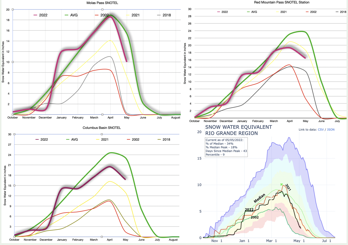
This year neither the Rio Grande nor the Pecos watershed has done all that well, snowpack-wise. Not many watersheds have, although Southwest Colorado is in better shape than it was last year. Snow season is pretty much over. That doesn’t mean it won’t snow any more in the high country. It’s just that the snowpack peak has almost certainly passed, runoff is underway, and many lower elevation SNOTEL stations are registering zero, which can throw off basin-wide graphs. So, below we offer the snowpack season finale with May 1 readings at our three go-to high country SNOTEL , plus the current graph for the Rio Grande Basin.
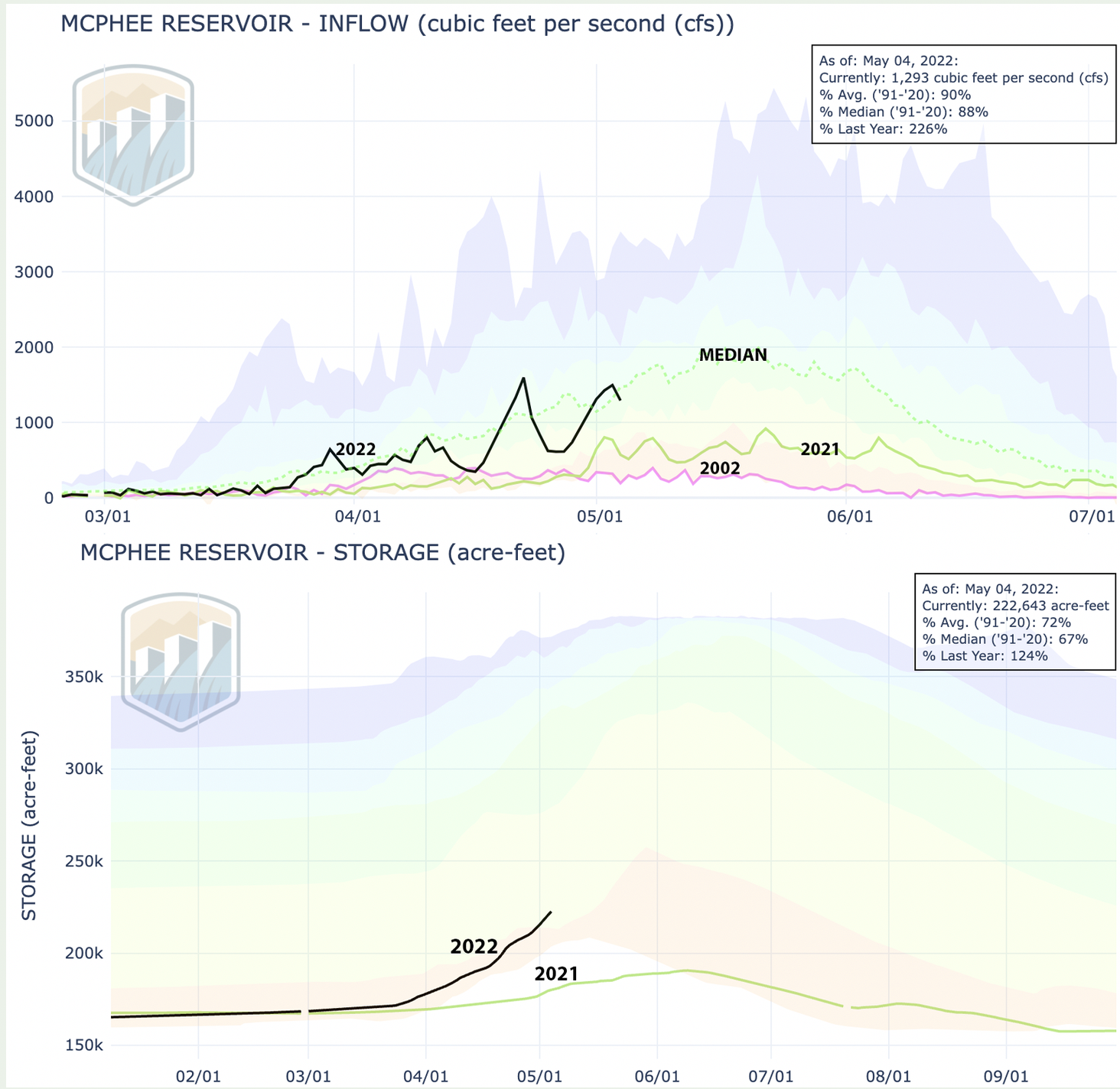
The bright spot is definitely Columbus Basin, high in the La Plata Mountains. It’s below the average level for the period of record, but still doing far better than 2021. The La Platas feed the Animas, La Plata, Mancos, and Dolores Rivers. Last year the Dolores had an awful year. Things are looking up this time around—relatively speaking. The Dolores River through its namesake town shot up to 1,800 cfs at one point, dropped, then shot back up again, pushing up levels at McPhee significantly. Still, don’t goo excited. McPhee’s only at 59% of capacity and water managers are releasing virtually nothing from the dam.
River runners better get out on the water now, while they still can.