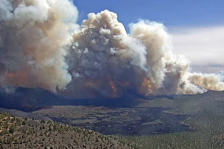
The Southwest U.S. is on fire, iconic deserts and towns are at risk and Biden has issued a disaster declaration — The Conversation

Wind quickly spread a blaze that burned homes near Flagstaff, Ariz., in April 2022.
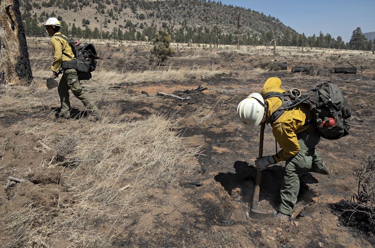
Coconino National Forest via AP

Molly Hunter, University of Arizona

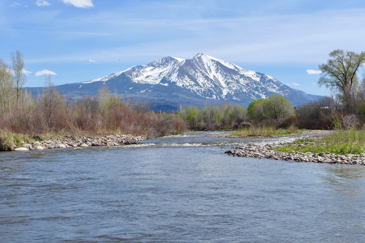
New Mexico and Arizona are facing a dangerously early fire season. It has left neighborhoods in ashes and is having such devastating effects that President Joe Biden issued a disaster declaration for New Mexico. Over 600 fires had broken out in the two states by early May, and large wildfires had burned through hundreds of homes near Ruidoso and Las Vegas, New Mexico, and Flagstaff, Arizona.

We asked wildfire scientist Molly Hunter at the University of Arizona to explain what’s fueling the extreme fire conditions and why risky seasons like this are becoming more common.

Why is this year’s wildfire season in the Southwest so early and intense?

Historically, fire season in the Southwest didn’t ramp up until late May or June, because fuels that carry fires – primarily woody debris, leaf litter and dead grasses – didn’t fully dry out until then.

Now, the Southwest is seeing more fires start much earlier in the year. The earlier fire season is partly due to the warming climate. As temperatures rise, the snow melts more rapidly, more water evaporates into the atmosphere and the grasses and other fuels dry out earlier in the season.

Unfortunately, the earlier timing coincides with when the region commonly experiences strong winds that can drive rapid fire growth. Some of the fires we’re seeing this year, like the Tunnel Fire near Flagstaff and the fires in New Mexico, are being driven by these really intense wind events. They’re pretty typical winds for spring, but fuels are now really dry and ready to burn.

Two fire crew members use axes to chop at burning roots on a charred desert landscape.
Fire crews dig at burning roots in the wake of a fire near Flagstaff, Ariz., in April 2022.
Tom Story/Northern Arizona Type 3 Incident Management Team, via AP

This year we also have a lot of fuel to burn. Last summer, in 2021, the Southwest had an exceptional monsoon season that left green hillsides and lots of vegetation. By now the grasses and forbs that established during the monsoon have dried out, leaving a lot of biomass that can carry a fire. Often in the Southwest, our biggest fire years come when we have a wet period followed by a dry period, like the La Niña conditions we’re experiencing now.

What role does climate change play?

In the Southwest, climate change has meant warmer, drier conditions. One immediate effect is the lengthening of the fire season.

We now see fires starting in March and April. And if the Southwest doesn’t get a good summer monsoon – the region’s typical period of heavy rainstorms – fire season won’t really stop until we get significant rainfall or snowfall in fall and winter. That means more stress on firefighting resources, and more stress on communities facing fire, smoke and evacuations.

As fire season lengthens, states are also seeing more fires caused by human activities, such as fireworks, sparks from vehicles or equipment, and power lines. More people are moving out into areas that are fire-prone, creating more opportunities for human-caused ignitions.
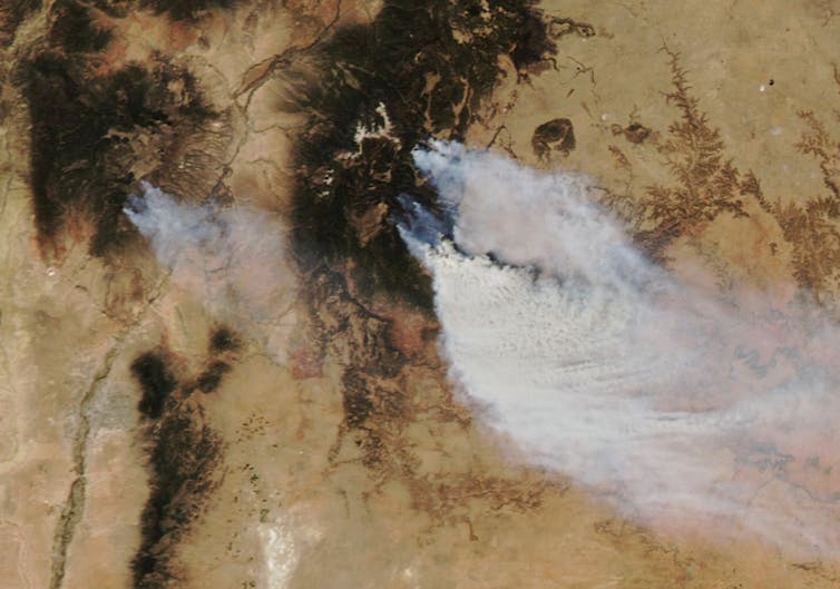
Satellite images shows fires burning near Las Vegas, New Mexico, and Los Alamos.
By May 4, nearly a quarter-million acres had burned in New Mexico, almost double the state’s 2021 total. Fires shown by satellite and on the map below are near Los Alamos and Las Vegas, N.M.
NASA
Map showing several large fires around Santa Fe, New Mexico, including in the town of Las Vegas, New Mexico

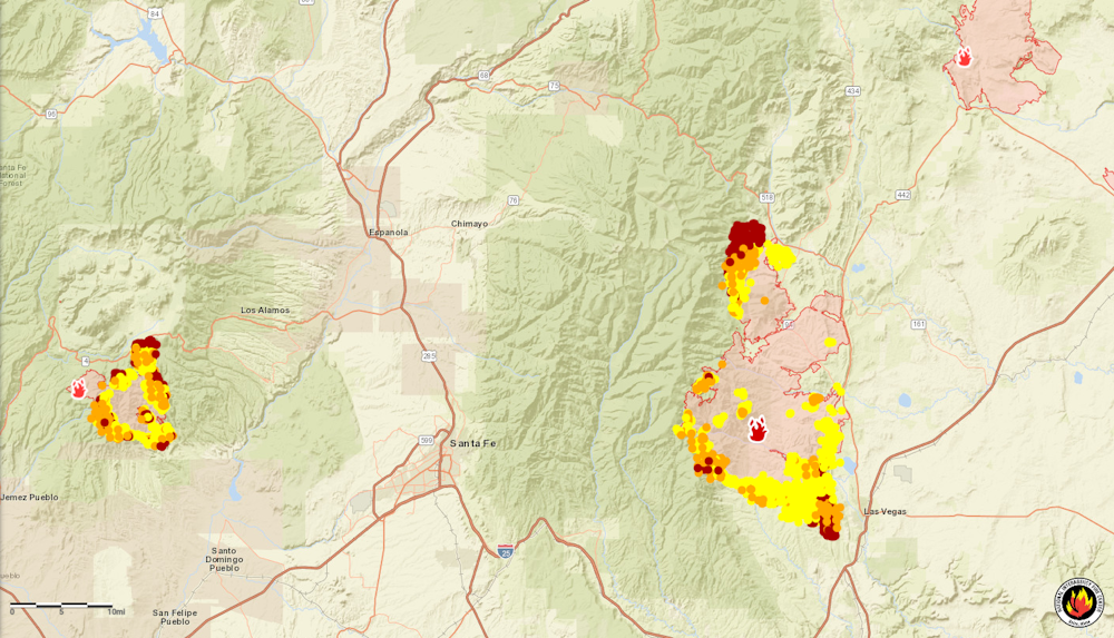
National Interagency Fire Center

What effect is the changing fire regime having on the Southwest’s ecosystems?

When fires burn in areas that didn’t see fire historically, they can transform ecosystems.

People generally don’t think of fire as being a natural part of desert ecosystems, but grasses are now fueling really big fires in the desert, like Arizona’s Telegraph Fire in 2021. These fires are also spreading farther, and into different ecosystems. The Telegraph Fire started in a desert system, then burned through chaparral and into the mountains, with pine and conifer forest.

Part of the problem is invasive grasses like buffelgrass and red brome that spread quickly and burn easily. A lot of grass is now growing in those desert systems, making them more prone to wildfire.

Invasive buffelgrass is a threat to desert ecosystems and communities.

When a fire spreads in the desert, some plant species, like mesquite and other brushy plants, can survive. But the saguaro – the iconic cactuses that are so popular in tourist visions of the Southwest – are not well adapted to fire, and they often die when exposed to fire. Paloverde trees are also not well adapted to survive fires.

What does comes back quickly is the grasses, both native and invasive. So in some areas we’re seeing a transition from desert ecosystem to a grassland ecosystem that is very conducive to the spread of fire.

The Cave Creek Fire near Phoenix in 2005 is an example where you can see this transition. It burned over 240,000 acres, and if you drive around that area now, you don’t see lot of saguaros. It doesn’t look like desert. It looks like more like annual grassland.

This is an iconic landscape, so the loss affects tourism. It affects wildlife as well. A lot of species rely on saguaro for nesting and feeding. Bats rely on the flowers for nectar.

What can be done to avoid high fire risk in the future?

In some respects, people will have to recognize that fire is inevitable.

Fires quickly now surpass our capacity to control them. When winds are strong and the fuels are really dry, there’s only so much firefighters can do to prevent some of these big fires from spreading.

A man throws a large log , just cut down, as he and other clear a fire line.
People clear trees from around a home as a fire threatens Las Vegas, N.M., on May 2, 2022.
AP Photo/Cedar Attanasio

Conducting more prescribed fires to clear out potential fuel is one important way to lessen the probability of really big, destructive blazes.

Historically, far more money went into fighting fires than managing the fuels with tactics like thinning and prescribed fire, but the infrastructure bill signed in 2021 included a huge influx of funding for fuels management. There’s also a push to move some seasonal fire crew jobs to full-time, yearlong positions to conduct thinning and prescribed burns.

Homeowners can also be better prepared to live with fires. That means maintaining yards and homes by removing debris so they’re less likely to burn. It also means being prepared to evacuate.

This article was updated May 5 with Biden issuing the disaster declaration.The Conversation

Molly Hunter, Associate Research Professor in Environment and Natural Resources, University of Arizona

This article is republished from The Conversation under a Creative Commons license. Read the original article.

The #ColoradoRiver District (CRD) annual “Middle Colorado State of the River” recap

The Roaring Fork River just above Carbondale, and Mt. Sopris, on May 3, 2020. Photo credit: Brent Gardner-Smith/Aspen Journalism

Click the link to read the article on Sopris Sun website (James Steindler). Here’s an excerpt:

Becky Bolinger, the assistant state climatologist at the Colorado State University Climate Center, was the first presenter. She explained that snowpack determines the rivers’ flows. “Even though we’re doing okay with snowpack, we really needed above average snowpack to get the inflows back to where they need to be,” she stated.

West Drought Monitor map May 3, 2022.

“We are still struggling through this long-term drought situation,” Bolinger stressed. “The summer heat is a big concern and what the precipitation does is also going to be a big concern.”

[…]

[Linsay DeFrates] further stated that with every 1% rise in temperature, streamflow is reduced by 3-9%. “Last year, we ended at 89% snowpack, but we only had 32% inflow into Lake Powell,” DeFrates explained. She referred back to Bolinger’s presentation, stating that “thirsty soils are going to drink the snowmelt first, before it becomes streamflow.”

She continued, “As we go forward, it’s going to take organization nights like this where voices are brought to the table who might not have been there before. … It’s going to take recognizing that we can’t just wish away our reality anymore.”

#Drought news (May 5, 2022): In the #ColoradoRiver Basin, #LakePowell was at 24% of capacity and Lake Mead 31% of capacity on May 3 #COriver #aridification

Click the link to view a gallery of drought data from the US Drought Monitor.

Click the link to go to the US Drought Monitor website. Here’s an excerpt:

This Week’s Drought Summary

This U.S. Drought Monitor (USDM) week was marked by ongoing active weather across areas of the conterminous U.S. including the Pacific Northwest, Northern Rockies, Plains, Lower Midwest, and isolated areas of the South and Southeast. The most severe weather was observed across the Central Plains and areas of the Midwest where numerous tornadoes touched down in areas including eastern Kansas, southeastern Nebraska, and northern Illinois. Widespread heavy rainfall accumulations were also observed, ranging from 2 to 7 inches, with the heaviest accumulations in eastern Nebraska. The rainfall events provided much-needed moisture to the region―boosting soil moisture levels across parched areas from Kansas to South Dakota. In the West, fast-moving storm systems delivered late season high-elevation snowfall to the Cascades of northern Oregon and Washington, the Northern and Central Rockies, and areas of the northern Great Basin. The highest snowfall totals (8 to 12+ inches) were observed in the Salmon River Mountains of Idaho, the Ruby Mountains of northeastern Nevada, and the Wind River Range of Wyoming. In California and the Southwest, conditions were dry during the past week with strong winds observed across the region. The windy, dry conditions exacerbated fire-weather conditions in Arizona and New Mexico where several large early-season wildfires are currently impacting the region. In northern New Mexico, the Hermits Peak Fire, situated east of Santa Fe in the Sangre de Cristo Mountains, has burned 147,909 acres and is only 20% contained (May 4), according to the National Interagency Coordination Center. On the water-resource front, the Colorado River Basin water situation continues to deteriorate due to the long-term impacts of drought with water levels at Lake Powell and Lake Mead currently at 24% full and 31% full, respectively. With Lake Powell’s water surface elevation currently at 3,522 feet, it is quickly approaching the 3,490-foot threshold level at which Glen Canyon Dam can continue to generate hydropower. The U.S. Bureau of Reclamation (USBR) announced (May 3) two urgent drought response actions to help bolster water levels at Lake Powell. The plan includes additional upstream releases from the Flaming Gorge Reservoir (~500,000 acre-feet [kaf] of water) as well as reducing Glen Canyon Dam’s annual release volume from 7.48-million acre-feet to 7 million acre-feet. In terms of this week’s map, short-term precipitation led to targeted improvements in the Pacific Northwest, Central Plains, South, and the Southeast, while degradations were registered in the Southwest, Texas, Southeast, and the Mid-Atlantic…

High Plains

On this week’s map, widespread improvements were made in South Dakota, Nebraska, and Kansas in response to significant rainfall accumulations that helped to improve soil moisture levels and boosted streamflow levels. Rainfall totals for the week ranged from 2 to 8+ inches with the highest totals observed in central South Dakota, eastern and central Nebraska, and northern Kansas. However, some drought-stricken areas of the region, including extreme southeastern South Dakota, northeastern Nebraska, and central Kansas, largely missed out on this week’s storms. In the eastern plains of Montana, improving conditions (precipitation, soil moisture) led to reduction in areas of Severe Drought (D2) and Extreme Drought (D3). However, it should be noted that recent improvements in eastern Montana are not uniform and many areas are still coping with the impacts (agricultural) of the longer-term drought situation. Average temperatures were below normal across the northern half of the region, with negative departures ranging from 2 to 10+ deg F below normal and the greatest departures observed in eastern portions of the Dakotas. In the southern half of the region, average temperatures were 2 to 8 deg F above normal…

Colorado Drought Monitor one week change map ending May 3, 2022.

West

Out West, several storm systems moved through the norther tier of the region bringing light to moderate snowfall accumulations to the higher elevations of the Cascades, northern Great Basin, and the Central and Northern Rockies as well as light rainfall to coastal areas and low-lying inland valleys of Idaho, Oregon, and Washington. Improvements were made in areas of Moderate Drought (D1), Severe Drought (D2), Extreme Drought (D3), and Exceptional Drought (D4) in Oregon in response to a combination of factors including normal to above-normal SWE, recent storm events, and improved soil moisture levels and streamflows. Likewise, improving conditions in northern Wyoming led to removal of areas of Extreme Drought (D3) in the Big Horn Mountains where current SWE is 108% of median. Elsewhere, conditions deteriorated on the map in northwestern Arizona and across much of New Mexico. Looking at snowpack data across the West at a regional scale (2-digit HUC), the NRCS SNOTEL network (May 3) reported the following median SWE levels: Pacific Northwest 111%, Missouri 99%, Souris-Red-Rainy 116%, California 60%, Great Basin 62%, Upper Colorado 76%, Arkansas-White-Red 50%, Lower Colorado 36%, and Rio Grande 33%. According to NRCS National Water and Climate Center’s reservoir summary report (April 1), statewide reservoir storage levels were below normal in all western states with exception of Washington state. In California, the state’s two largest reservoirs are at critically low levels moving into the dry season with Shasta Lake currently at 40% of total capacity on May 3 and Lake Oroville at 55% of capacity. In Southern California, the Metropolitan Water District of Southern California announced (April 27) that one-third of its users will be subject to restrictions that limit outdoor watering to one day per week as a measure to reduce water usage. In the Colorado River Basin, Lake Powell was at 24% of capacity and Lake Mead 31% of capacity on May 3, according to the USBR. In the Rio Grande Basin, New Mexico’s Elephant Butte Reservoir was 13% full…

South

In the South, conditions on the map were a mixed bag of improvements and degradations. In southern Louisiana, isolated areas of light-to-moderate rainfall (2 to 4 inches) improved areas of Moderate Drought (D1), Severe Drought (D2), and Extreme Drought (D3) as well as eliminated pockets of Moderate Drought (D1) in northern Louisiana and southern Arkansas. In areas of Texas (Panhandle, north-central, west-central, Trans-Pecos), isolated bands of heavy rainfall (2 to 4 inches) helped to improve drought-affected areas. Conversely, the combination of above-normal temperatures, dry soils, and increased evaporative demand led to degradation in areas of the Panhandle, southeastern Texas, and the Trans-Pecos. In the Panhandle of Oklahoma, small areas of Exceptional Drought (D4) expanded in response to short-term rainfall deficits. Reports in this area include very poor rangeland conditions and local ranchers having to rely on supplemental feed for cattle. According to the latest USDA Oklahoma Crop Progress and Conditions report (May 2), wheat crop conditions were rated 51% poor to very poor and soil moisture was 63% short to very short. For the week, average temperatures were mostly above normal (2 to 8+ deg F) with the greatest positive anomalies observed across Texas and western Oklahoma…

Looking Ahead

The NWS WPC 7-Day Quantitative Precipitation Forecast (QPF) calls for moderate-to-heavy liquid (liquid = rain + SWE) precipitation accumulations ranging from 2 to 5+ inches across eastern portions of the Central and Southern Plains and the Lower Mississippi Valley. In the Lower Midwest and the Mid-Atlantic, precipitation totals are expected to range from 1 to 3 inches. Out West, accumulations ranging from 1 to 5 inches are forecasted for the coastal ranges and the Cascades of western Oregon and Washington. Further inland, lighter accumulations (< 2 inches) are expected in the Northern Rockies of Idaho, Montana, and Wyoming. Further south, conditions are expected to be dry across California, the Great Basin, and the Desert Southwest. The CPC 6-10-day Outlooks calls for a moderate-to-high probability of above-normal temperatures across the eastern two-thirds of the conterminous U.S. with exception of some coastal areas of the Mid-Atlantic and Florida. Below-normal temperatures are expected across much of the West with exception of eastern portions of Colorado and New Mexico where there is a low-to-moderate probability of above-normal temperatures. In terms of precipitation, the wetter-than-normal pattern is expected to persist across the northern tier of the West as well as in areas of the Great Plains. In coastal areas of the Far West, near-normal precipitation is expected. Across much of the eastern half of the conterminous U.S., including areas of the Southern Plains, Lower Midwest, Mid-Atlantic, and the Northeast, there is a moderate-to-high probability of below-normal precipitation.

US Drought Monitor one week change map ending May 3, 2022.

Just for grins here’s a gallery of early May US Drought Monitor maps from the US Drought Monitor.

This slideshow requires JavaScript.

The May 1, 2022 CBRFC unregulated #LakePowell April-July inflow forecast has dropped 300kaf to 3.8 maf #ColoradoRiver #COriver #aridifcation