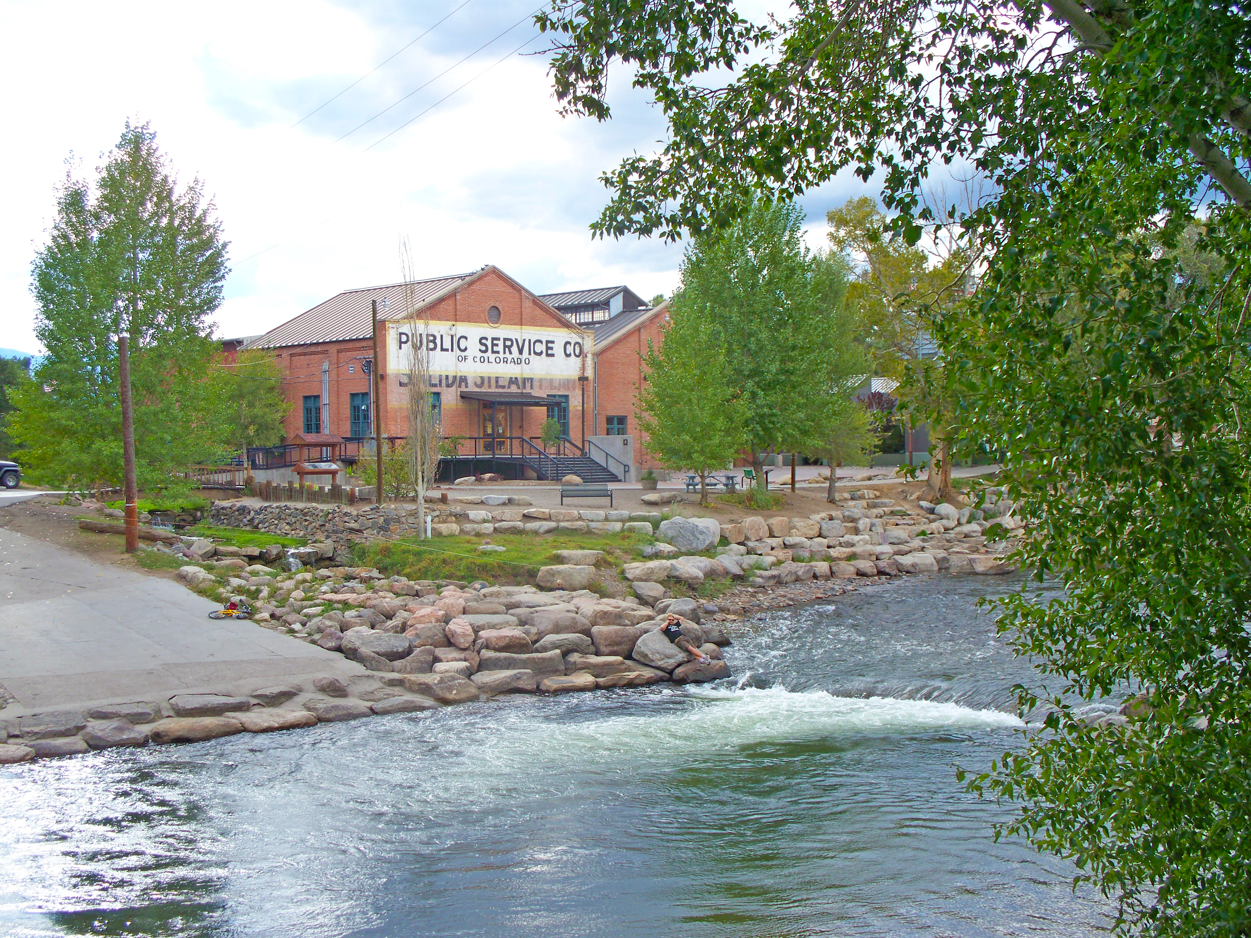
Roy Vaughan relaxes with his family at the Salida Steam Plant shortly after receiving the Bob Appel Friend of the Arkansas Award at the 26th annual Arkansas River Basin Water Forum Thursday, April 28, 2022. Photo credit: Southeastern Colorado Water Conservancy District
Here’s the release from the Southeastern Colorado Water Conservancy District (Chris Woodka):
Roy Vaughan, who retired as the Bureau of Reclamation manager of the Fryingpan-Arkansas Project in 2021, was awarded the Bob Appel Friend of the Arkansas Award Thursday at the 26th annual Arkansas River Basin Water Forum.
“I had no idea I would be getting the award,” Vaughan said. “I really need to thank all of the people I worked with for this great honor.”
Vaughan was surprised by his wife, Stasi, and grown sons Chaz and Colton at the event as they walked onto the stage at the Salida Steam Plant, noting that the day was the 38th anniversary of their wedding.
Pueblo Dam
Vaughan began working for Reclamation in 1992 as dam superintendent at Pueblo Dam, which led him to an interest in all of the water operations of the Arkansas Valley, and water operations such as the Fry-Ark Project that import water from the western slope. He became manager of the Fry-Ark Project in 2008.
Last year’s recipient, Upper Arkansas Water Conservancy District Manager Terry Scanga, presented the Appel award and read excerpts from 14 people who worked with him during his career in all parts of the Arkansas River basin. He helped bring people together over such controversial issues as the Preferred Storage Options Plan, Southern Delivery System and Voluntary Flow Management Program. He was always eager to patiently explain water operations with a quick wit and great sense of humor.
“He felt the weight of occasionally failing to satisfy everyone’s wishes far more than he enjoyed the buoyancy of the many times he did indeed satisfy them,” wrote Chaffee County Commissioner Greg Felt. “Perhaps this is the price of being a conscientious public servant. Certainly, it is evidence of a deep regard for all of the envisioned benefits of the Fry-Ark Project.
The Appel Award is named for Bob Appel, who promoted the Arkansas River as coordinator of the Southeast Colorado Resource Conservation and Development Council until his death in 2003.
For more information, contact Jean van Pelt, Forum Coordinator, at arbwf1994@gmail.com.
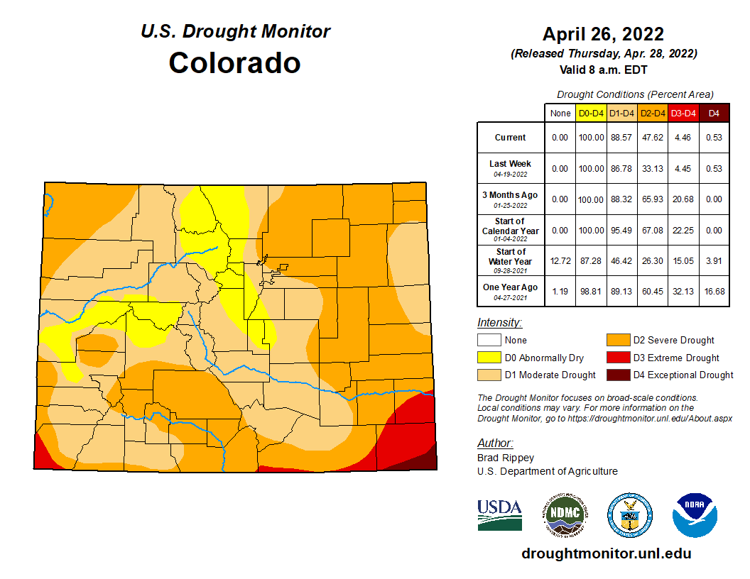
Colorado’s drought situation is a little better than it was a year ago, but warm temperatures, windy conditions in April and almost no precipitation in parts of the state means the snowpack is melting a couple of weeks sooner than most water watchers would prefer. The state’s Water Availability Task Force met on April 19 to look at the most recent numbers from the Colorado Climate Center at Colorado State University and the Natural Resources Conservation Service, which is a part of the U.S. Department of Agriculture…
From October to March — the first six months of a water year that started Oct. 1 — it’s been much drier than average in southern Colorado, the San Luis Valley and Rio Grande River basin, and on the Eastern Plains, but wetter than normal in northwestern Colorado, Peter Goble said. April ends the wet season for the mountains and begins the wet season for the Eastern Plains. But the moisture has stayed away from the Eastern Plains, Goble said…
Colorado Drought Monitor map April 26, 2022.
According to the U.S. Drought Monitor, which reports drought conditions weekly, while the entire state is in some level of drought, compared to a year ago Colorado is not seeing the worst levels, known as exceptional drought. That’s particularly true for the Western Slope, with snowpack in better shape now than a year ago, Goble said. The next six weeks will be critical for the Eastern Plains, he added…
NRCS hydrologist Karl Wetlaufer offered slightly better news when it comes to the state’s water supply, including for reservoir storage. While not a drought buster, water storage is substantially better than it’s been the last couple of years, he said. The expectation is that snowmelt is ramping up and unfortunately sooner than hoped for, he said…
The state’s trouble spots are in the Upper Rio Grande and in the lower Arkansas, according to Wetlaufer’s data. The Rio Grande is already seeing substantially earlier snowmelt, he said. It’s unlikely there will be enough precipitation to gain even average streamflows in the river, he said. That’s going to be a problem for the streamflow in areas like the southern Sangre de Cristos, and that in turn will affect compacts tied to the lower Rio Grande, which flows into New Mexico.
The Gunnison River Basin snow water equivalent (SWE) as of April 10 was 96% of normal for this time of year, and the upper basin SWE was 92% of normal. Precipitation has ranged between 69% to 82% of average for the entire upper basin since December and soil moisture varies from 1-31% of normal in Gunnison County, with most areas at an average of 10%.
“The Gunnison River looks like it might be similar to last year, for example the Gunnison River at Gunnison stream gage peaked at 1,720 cfs, but we’re hoping for more as there was more snowpack than last year,” she said. “Storage in the entire Upper Colorado River Basin is 63% of average right now, and Blue Mesa and Lake Powell are the lowest in that system.”
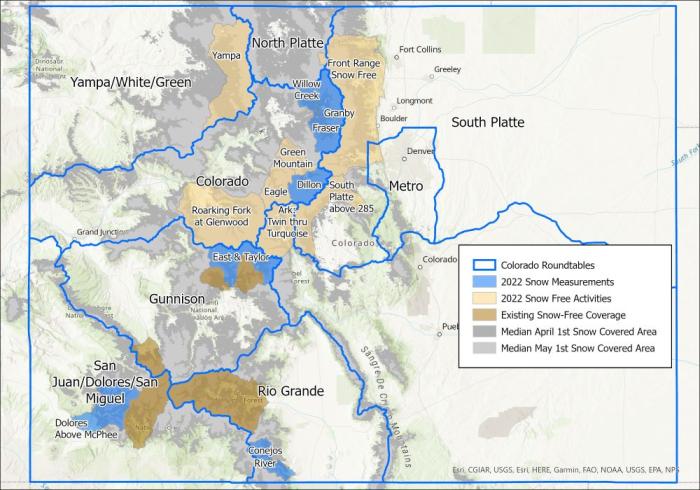
The blue areas in the map above are where the Airborne Snow Observatory flights are scheduled to collect information about the snowpack in 2022. The light tan areas will be flown this summer and fall to collect baseline information about the ground when it is free of snow. Image credit: Lynker.
Richards described a few potential tools being considered in the basin, such as Rocky Mountain Biological Laboratory’s (RMBL) interest in an airborne remote sensing program to track moisture during peak “greenness” from March through October. She said the program would help inform water managers of snow melt timing in the future. Chavez said the UGRWCD is also hoping to work more closely with USGS to increase monitoring frequency in Blue Mesa to understand Harmful Algal Blooms (HABs) using satellite and stream and lake sampling and might apply for a grant to aid in the endeavor.
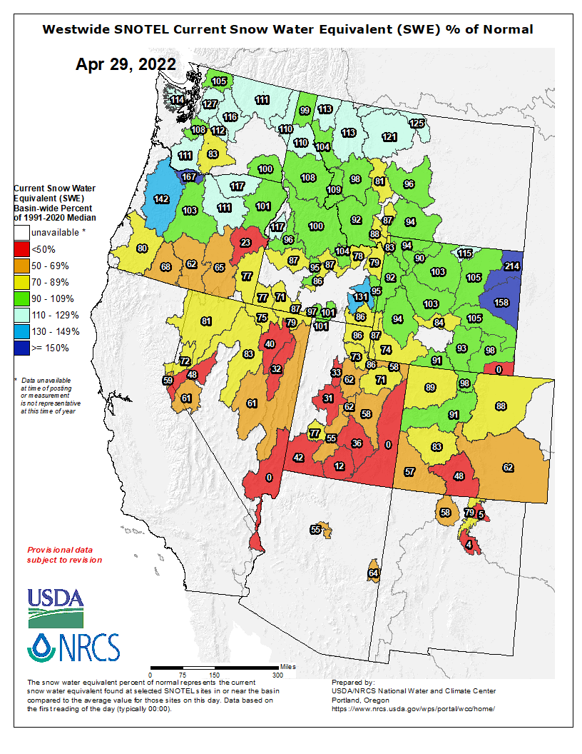
Westwide SNOTEL basin-filled snowpack map April 29, 2022 via the NRCS.
Water forecasts remain below average, but above last year’s troubling lows – a positive sign for water managers adapting to sustained drought in the region. Yet, much will depend on the impact of recent dust events and summer monsoons.
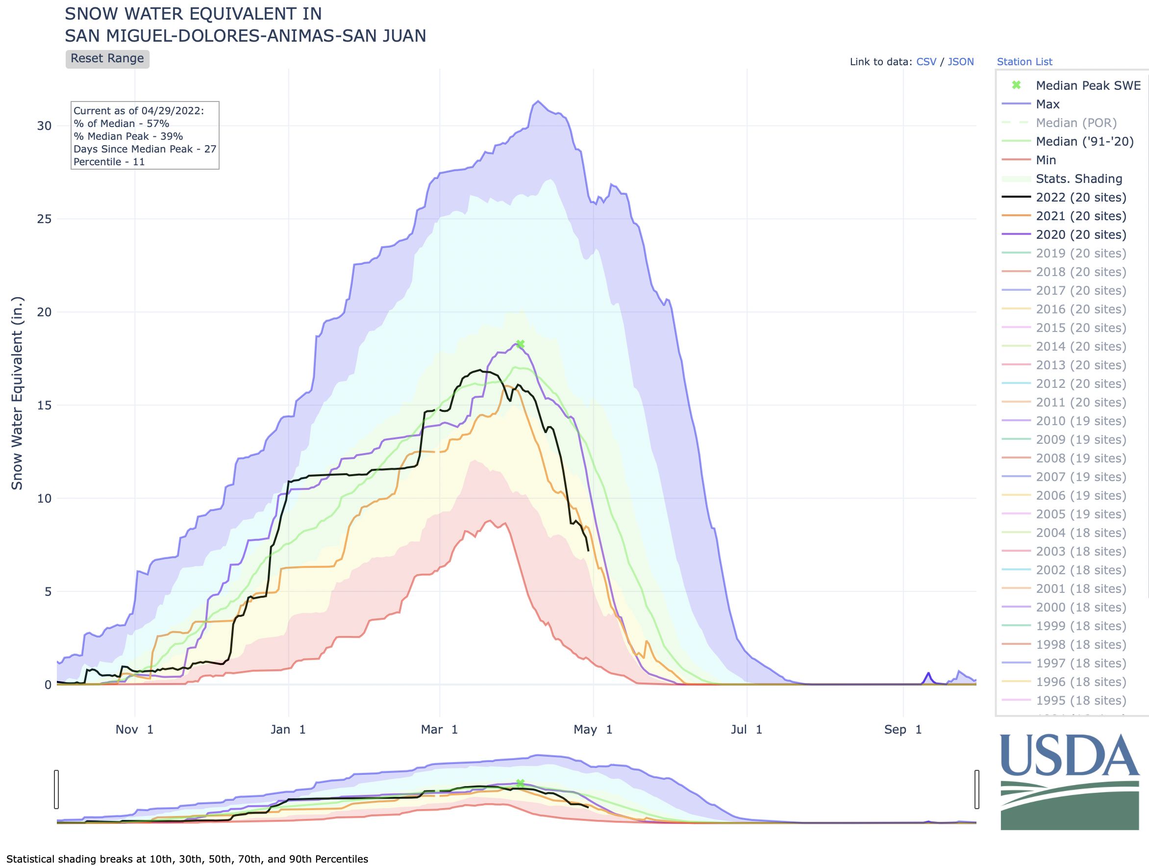
According to SNOTEL data from the U.S. Department of Agriculture’s National Resources Conservation Service, a little more than half of the snowpack in the San Miguel, Dolores, Animas and San Juan basins has melted so far. Snowpack is measured using the metric of snow water equivalent, or the water content of the snow.
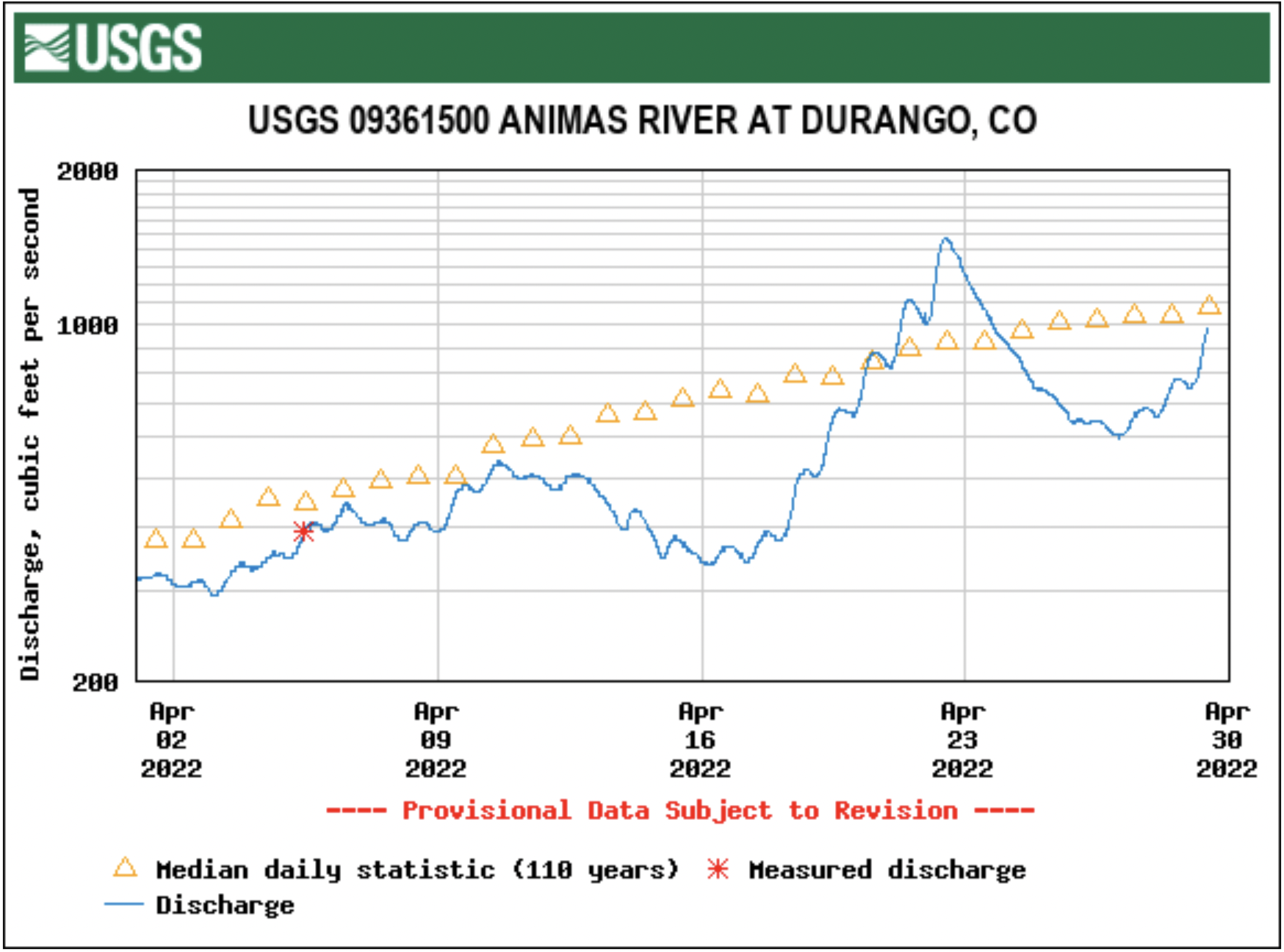
The Animas River was flowing at 669 cubic feet per second in Durango on Wednesday afternoon, the Dolores River at 556 cfs in Dolores and the San Juan River at 895 cfs, according to Colorado Basin River Forecast Center data. Southwest Colorado’s rivers have slowed since Friday, but the Colorado Basin River Forecast Center predicts that flows will again increase over the next week and a half. Forecasts show the Animas River will peak at 3,100 cfs in late May or early June, slightly above last year’s peak of 2,910 cfs on June 7. Forecasts project peaks of 1,500 cfs for the Dolores River and 1,600 cfs for the San Juan River also in late May and early June…
Snow is melting earlier than average this year, according to the SNOTEL data, a trend that Wolff and other water managers have noted. Typically, snowpack would peak around April 1 and runoff would last from April through May and even into June, Wolff said…While runoff is happening earlier this year, water supply forecasts suggest more optimism. The Animas, Dolores and San Juan rivers are hovering just above 70% of average, according to Colorado Basin River Forecast Center forecasts…
Ken Curtis, general manager for the Dolores Water Conservancy District, told Wolff the district was hoping to get at least 70% of its average water.
Releases from the Aspinall Unit will be increased from 500 cfs to 700 cfs on Saturday, April 30th. Then releases will be increased from 700 cfs to 900 cfs on Monday, May 2nd. Releases are being increased to correspond with the re-startup of diversions to the Gunnison Tunnel. Currently snowpack in the Upper Gunnison Basin is 91% of normal and the forecasted April-July runoff volume for Blue Mesa Reservoir is 80% of average.
Flows in the lower Gunnison River are currently above the baseflow target of 890 cfs. River flows are expected to stay at levels above the baseflow target for the foreseeable future.
Pursuant to the Aspinall Unit Operations Record of Decision (ROD), the baseflow target in the lower Gunnison River, as measured at the Whitewater gage, is 890 cfs for April and May.
Currently, Gunnison Tunnel diversions are 125 cfs and flows in the Gunnison River through the Black Canyon are around 350 cfs. After this release change Gunnison Tunnel diversions will be around 525 cfs and flows in the Gunnison River through the Black Canyon will be near 350 cfs. Current flow information is obtained from provisional data that may undergo revision subsequent to review.
Denver is poised to see its driest April in 150 years this month and drought continues to worsen, as only one one-hundredth of an inch of precipitation has fallen so far and there is only a slight chance of rain through the end of the month. Denver has also only seen a trace of snow this month officially, which would put this April tied for fourth for the least snowy Aprils on record behind 1992, 1943 and 1930, when no snow fell. The 0.01 inches of precipitation, if it stands, would mark the driest April since the National Weather Service in Boulder began keeping records in 1872. In 1963, 0.03 inches fell in April, and in 1878, just 0.05 inches of precipitation fell. This century, 2002 was the driest April so far, when only 0.23 inches of precipitation fell…
Denver averages 1.53 inches of precipitation in April, according to the NWS. But it can also see plenty of precipitation during the month, as the top 20 wettest Aprils on record all saw more than 3 inches of precipitation – including a record 8.24 inches in 1900. Denver has also seen some very snowy Aprils, which is typically the second-snowiest month for the city. The snowiest April ever was 1933, when 33.8 inches of snow fell…
Colorado Drought Monitor map April 26, 2022.
Severe drought crept back into northeast Denver, most of Adams County, eastern Arapahoe County, and most of the eastern plains over the past week – areas that were mostly considered to be experiencing only moderate drought just a week ago, according to the U.S. Drought Monitor.
Running for the open seats are Tammy Essmeier, Allen Dreher, Frank J. Johns, Neil L. Arney and Frank McNulty. Each candidate answered questions about themselves to provide Centennial Water voters with some information about their reason for seeking a seat on the board.
Arney is an attorney with knowledge of Colorado special districts who is new to Highlands Ranch and running to give back to his community.
Essmeier is a consultant on environmental regulations and laws, who has served as a volunteer with Centennial Water’s Citizen Engagement Committee.
Dreher, a former journalist, serves on the Highlands Ranch Metro District and is interested in joining the board to protect water sustainability.
Also a volunteer with the Citizen Engagement Committee, Johns is an engineer with previous experience operating water and wastewater facilities.
A former Colorado representative, McNulty owns Square State Strategy Group and previously served as the consulting attorney for the Colorado Department of Natural Resources.
Centennial Water users can vote in person from 7 a.m. to 7 p.m. May 3 at 92 Plaza Drive or drop an absentee ballot in the drop-box at the Douglas County Sheriff’s Office Highlands Ranch substation by 7 p.m. May 3.
Repairing Glenwood Canyon, Interstate-70 and mitigating future debris flow damages has cost state, federal and local governments about $27 million so far, a Colorado Department of Transportation spokesperson said. Joined by partnering agencies, CDOT Executive Director Shoshana Lew briefed media outlets Tuesday on efforts to repair the damage done to Glenwood Canyon by wildfires and historic debris flows in recent years…
Work is also expected to begin shortly on a primitive trail to Hanging Lake, Forest Service spokesperson David Boyd said. While the lake itself was spared by the debris flow events, the trail leading to the pristine woodland attraction was all but eliminated. Boyd said a trail reconstruction project is planned to begin Friday [April 29, 2022], which could install a primitive trail leading to the lake by mid-summer…
CDOT contractors Lawrence Construction and IHC Scott continue to remove material from the Colorado River at six locations throughout the canyon. More than 200,000 tons have been removed so far, CDOT Resident Engineer Andrew Knapp said…In addition to debris removal, CDOT is working with contractors and the U.S. Forest Service to build debris flow catchment fences, nicknamed “bathtubs,” alongside the roadways. The bathtubs create a basin where excess debris and water can collect during future events, minimizing impacts to the interstate and travelers, Knapp explained…
This summer, CDOT will be working with the National Oceanic and Atmospheric Administration to determine whether the canyon will remain open ahead of potential significant rain events above the Grizzly Creek burn scar. When NOAA issues watches or warnings about potential debris flow events, Blake said CDOT will close rest areas and the Glenwood Canyon Recreation Path. If NOAA issues a watch, CDOT staff will head out to closure points along I-70, and should a warning be issued, Blake said the canyon would be closed for the duration of the warning.
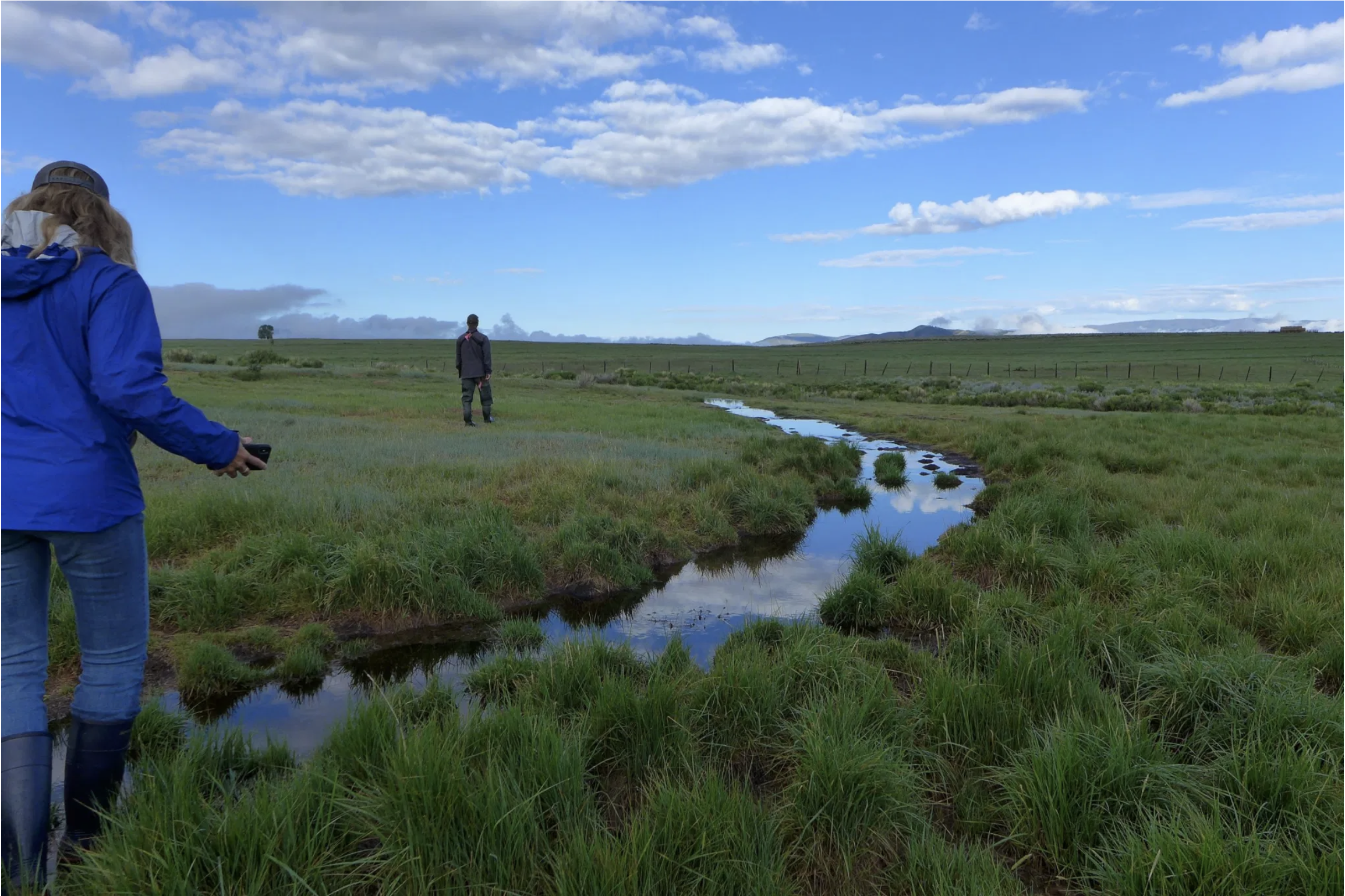
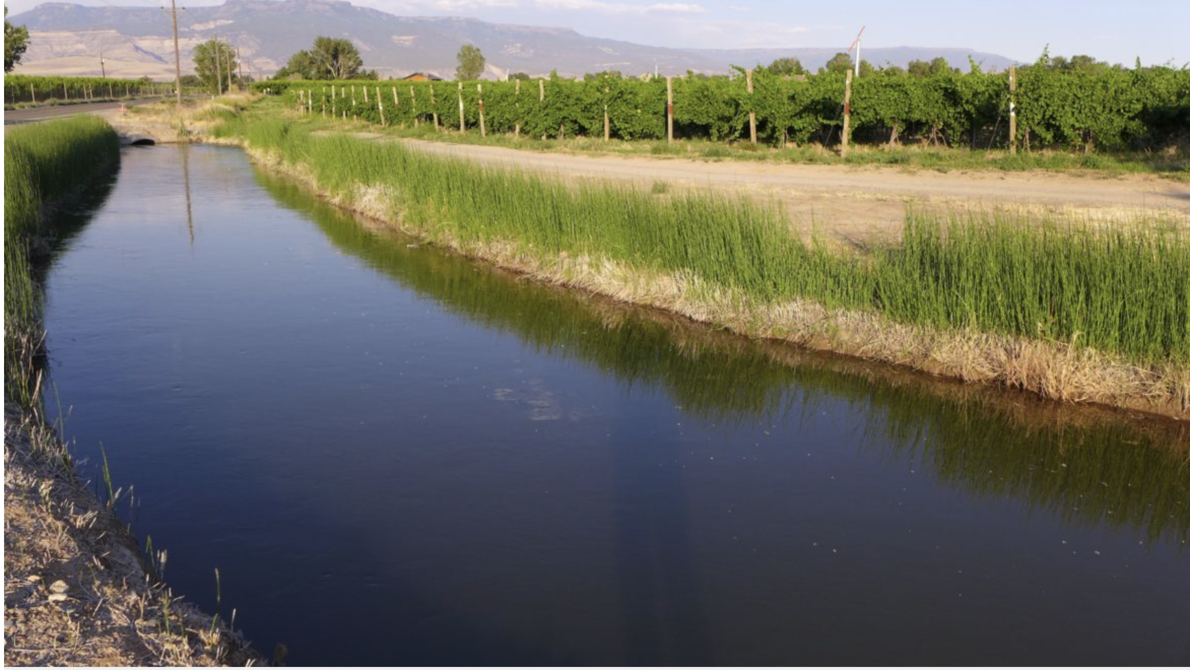
Wildlife biologist Bill Vetter and Western Rivers Regional Program Manager with Audubon Rockies Abby Burk walk along an irrigation ditch in Grand County. An avian monitoring program aims to learn more about how birds use irrigated agriculture. CREDIT: HEATHER SACKETT/ASPEN JOURNALISM
Click the link to read the article on the Sky-Hi News website (Meg Soyars). Here’s an excerpt:
If the lake does drop lower than 3,490 feet, it is uncertain how much water, if any, will be delivered to the communities that rely on it. Lake Powell doesn’t only supply water to millions of Americans, it also provides power through turbines at the Glen Canyon Dam. Below 3,490 feet, the dam will not be able to provide hydropower. All Colorado Basin states receive power from the dam. Kirk Klancke, president of the Colorado River Headwaters Chapter of Trout Unlimited, explained that the emergency at Lake Powell may seem far removed from Grand County, but it’s closely connected. Forty million people, from Wyoming to Mexico, rely on water from the Colorado River, including every Grand County resident. When someone turns on the tap here, they are getting the same water that will eventually get sent down to Lake Powell for a California (or other regional) resident…
Klancke feels the Lower Basin is demanding too much water from Lake Powell, and this may decrease the water supply of Upper Basin states like Colorado.
“My concern for Grand County is that our water rights will be cut into to make up the difference,” he said. “I worry they might go after our agricultural rights first … and (agriculture) makes up a huge part of our economy.”
A series of hot, dry years in the Upper Colorado River Basin has led to increasing concern about the security of water supplies at region-wide and local scales for the following purposes and sectors:
• Maintaining compact compliance and preventing Lake Powell’s water level from dropping too low to generate power.
• Maintaining agricultural production and the vitality of rural communities.
• Maintaining municipal and industrial water security.
• Maintaining river ecosystems.
Without a strategic, collaborative approach to addressing these issues, there is a risk that individual entities will act independently to secure their water supplies against climate and legal uncertainties. This could lead to more permanent transfers from agriculture, with detrimental impacts on rural communities and unpredictable impacts on river ecosystems.
Over the past several years, there have been numerous explorations into new approaches to meeting community and environmental needs in the Upper Basin, including deliberate, temporary, and compensated reductions in water use in order to help balance supply and demand in the Colorado River system, share water supplies between agriculture and cities, and aid troubled streams.
This report distills insights from these explorations that can help illuminate how such deliberate, temporary reductions in water use could play a role in:
• Enhancing long-term water security for farms, municipalities, industries and rivers in the Upper Basin (upstream objectives).
• Compact compliance and protection of power generation capacity in Lake Powell (downstream objectives).
In this report, the term “strategic conservation” will be used to describe these deliberate reductions in water use to meet specific goals.
The insights covered in this report focus on the following topics:
• Water user interest
• Agronomic impacts of reducing water use
• Monitoring and verification of saved water
• Shepherding and conveyance of conserved water
• Pricing considerations
• Environmental considerations
• Additional considerations
For each topic, key insights and remaining uncertainties are highlighted and illustrative research, experiences and resources are described. Links to documentation are provided wherever possible.
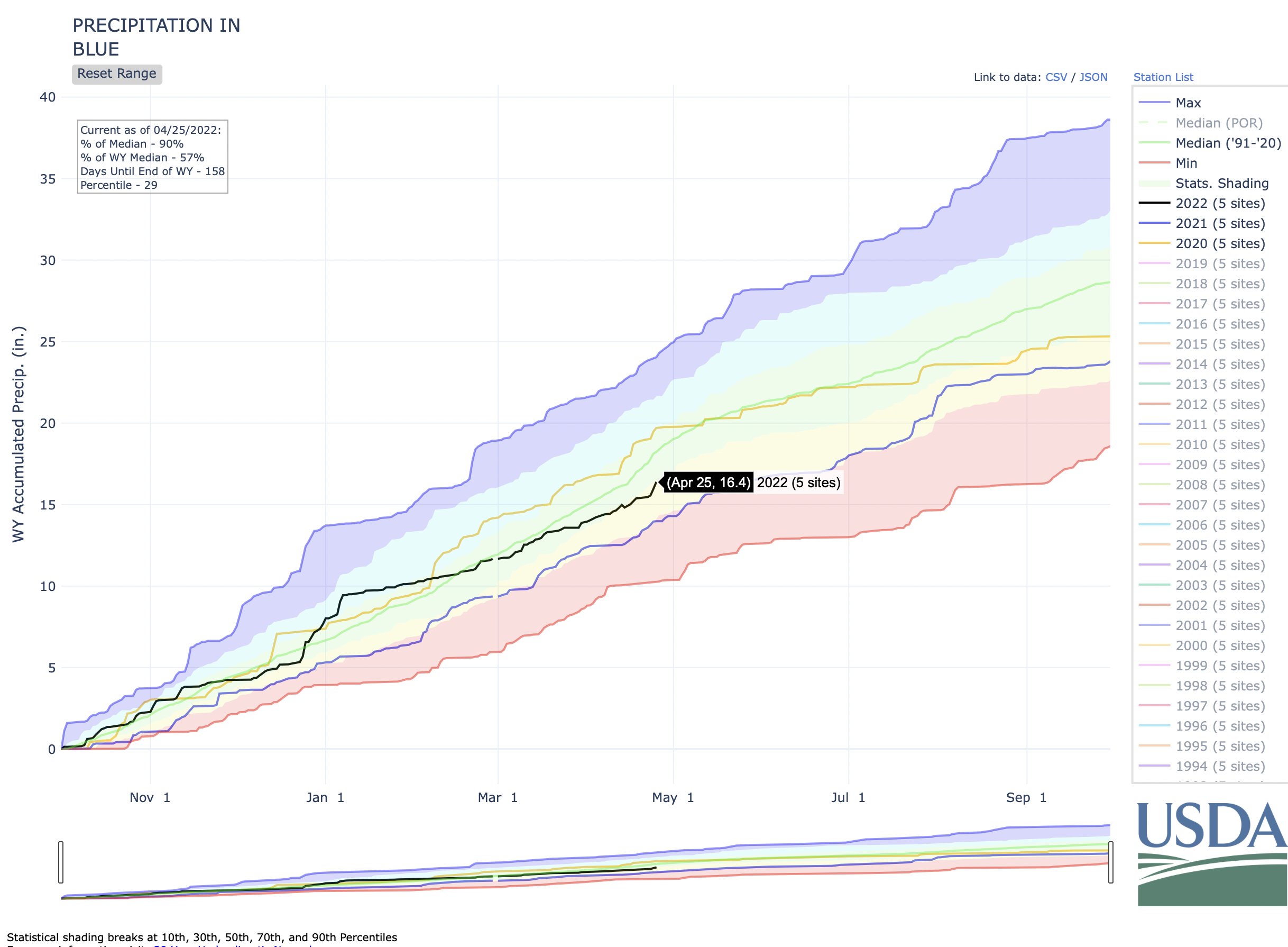
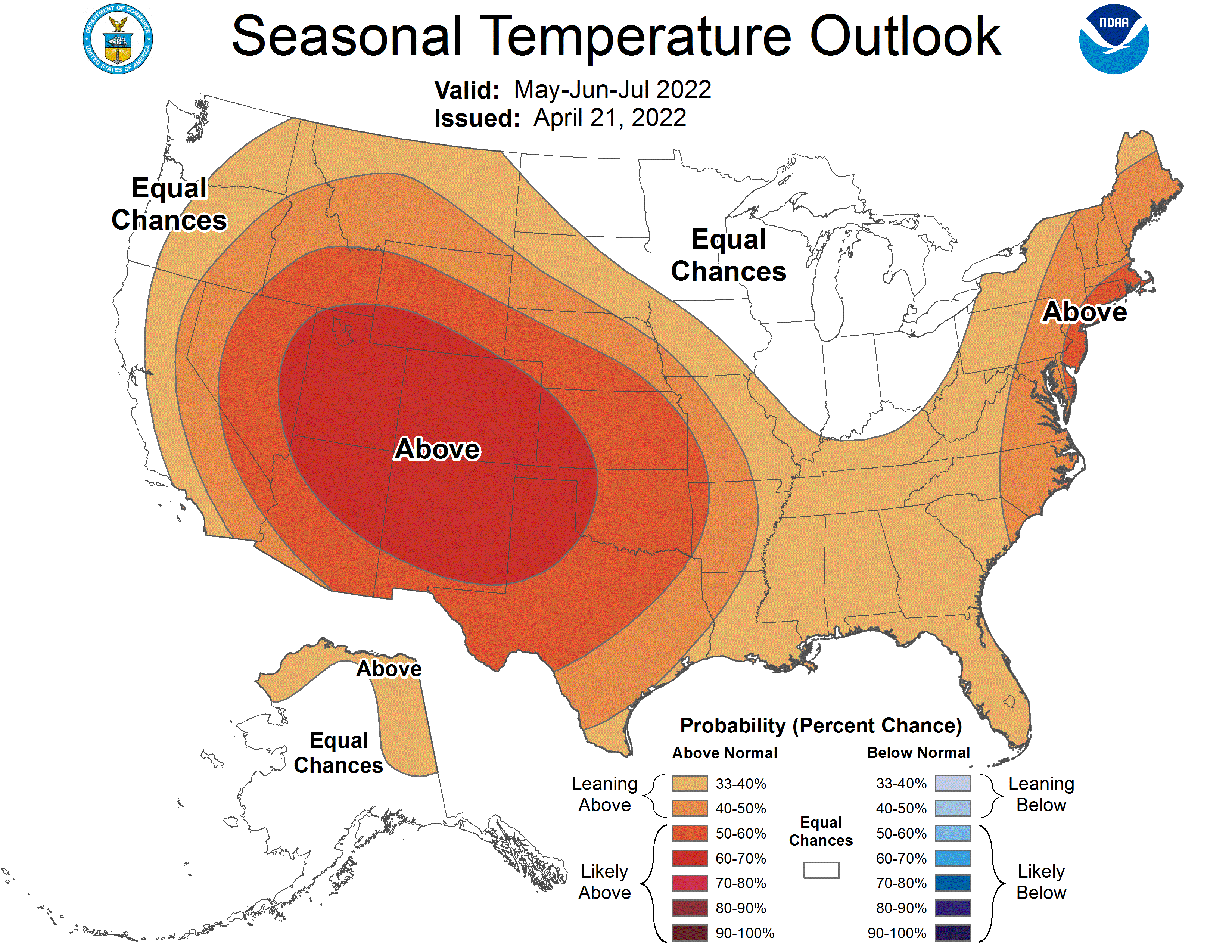
Colorado’s statewide snowpack sat at 82% of median [Thursday] compared to the last 30 years but is already past its peak amid water concerns in the Colorado River Basin and more than a dozen wildfires that have burned across the state over the past two weeks…
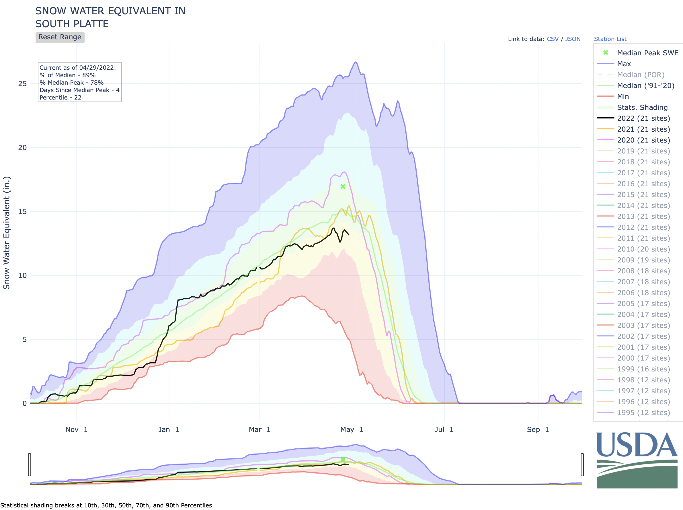
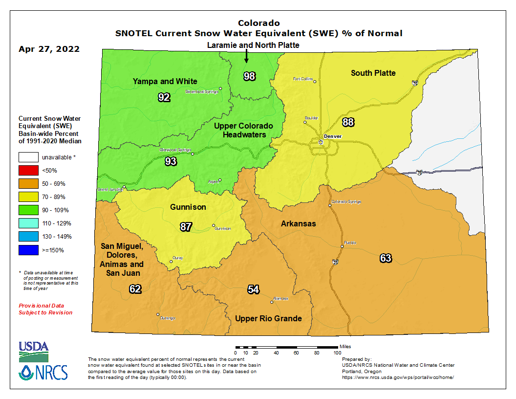
Colorado hit its median snowpack peak on April 8, according to the U.S. Department of Agriculture and the Natural Resources Conservation Service. It sat at 92% of median levels on Monday, with just two of the state’s eight river basins – the Gunnison (101%) and Upper Colorado Headwaters (100%) – at or above median levels. The Laramie and North Platte (98%), South Platte (92%), Yampa and White (92%) basins were all slightly below median levels. And the Arkansas (85%), Upper Rio Grande (84%), and the San Miguel, Dolores, Animas, and San Juan (80%) basins were slightly further below median levels. Statewide, the snowpack’s trajectory is about on par with median levels for the period of 1991-2020, according to USDA/NRCS data…
Colorado statewide snowpack graph April 28, 2022 via the NRCS.
The snowpack is in a slightly better place at this point than it was last year, slightly worse than this point in 2020, and about right in between the above-average year of 2019 and well-below-average year of 2018. It is at 81% of the median peak for the period of 1991-2020. Peter Goble, a research associate at Colorado State University who also works at the Colorado Climate Center at CSU, said the snowpack is slightly better than last year, and as the climate warms, the West should expect shorter snow seasons and lower peak snowpack levels…
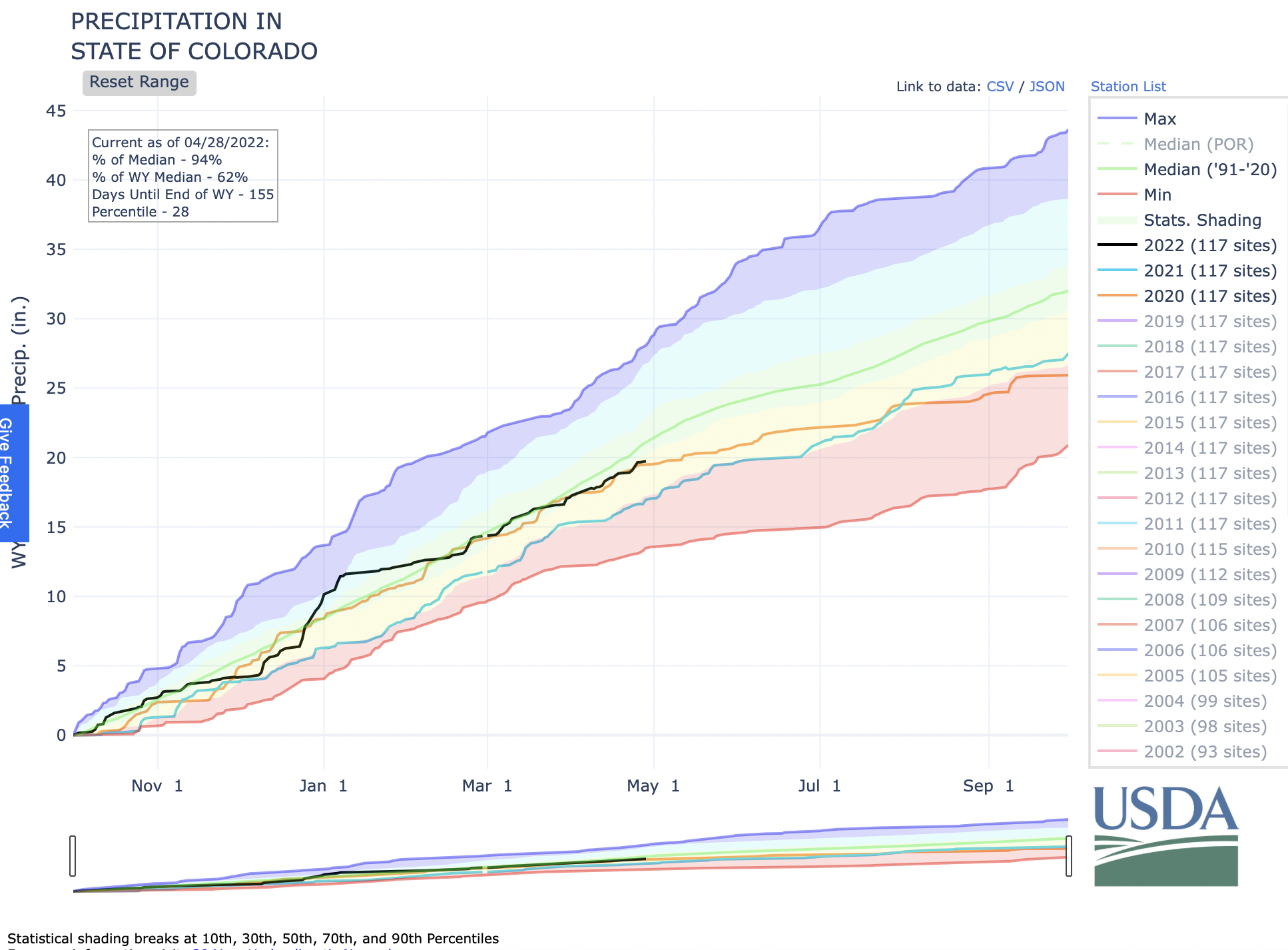
State of Colorado water year precipitation April 28, 2022 via the NRCS.
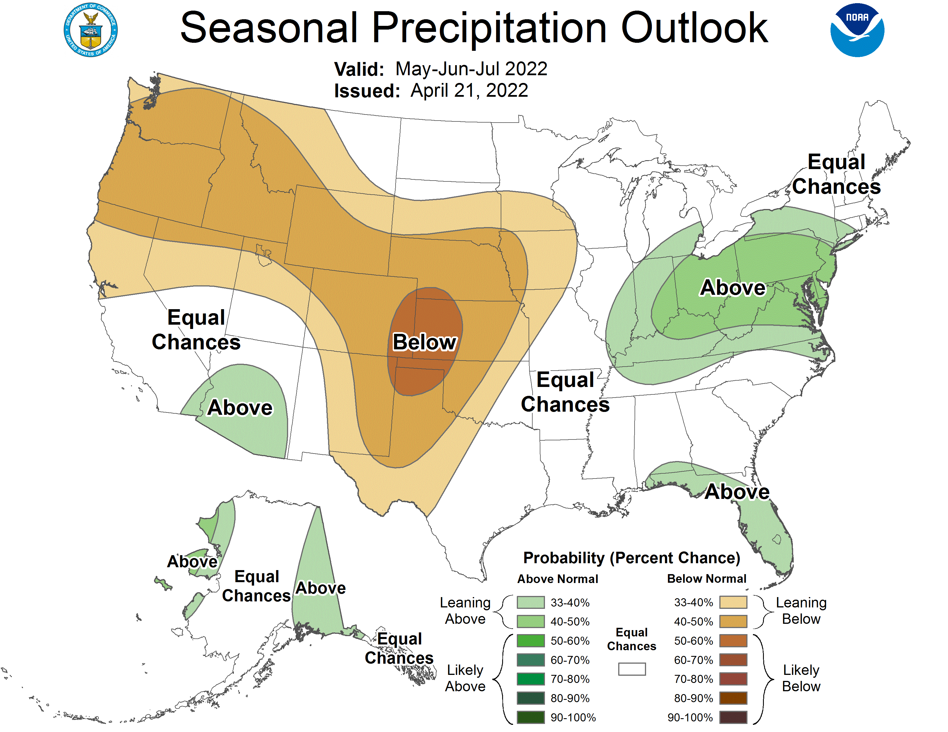
Another dataset shows southern Colorado is well behind its normal precipitation levels for the month of April so far based on SNOTEL measurements. The San Miguel, Dolores, Animas, and San Juan (48%) and Gunnison (49%) have both received about half the normal precipitation they typically receive by this point in April. And the Upper Rio Grande (59%) and Arkansas (61%) basins have fared slightly better this month but are still well below normal levels…
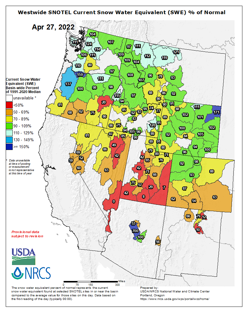
Westwide SNOTEL basin-filled map April 27, 2022 via the NRCS.
Meanwhile, the northern four basins are all near or above normal precipitation for the month. The Laramie and North Platte (138%), Yampa and White (106%), and South Platte (97%) were all close to or slightly above normal levels. The Upper Colorado Headwaters basin sat at 89% of normal in terms of April precipitation as of Monday, according to the USDA/NRCS data.
Southern Utah and eastern Nevada, part of the Colorado River Basin, have also been extremely dry so far this April and are seeing snowpack levels below 50% of median for this time of year. While snowpack in Wyoming and Colorado, where the headwaters of the rivers that feed the Colorado begin, is still close to median levels in most spots, every basin in Utah and Nevada was below 90% of median as of Monday…
An April 1 water forecast from the Colorado Basin River Forecast Center said as of the start of the month, snow water equivalent levels were between 75% and 105% in the Upper Colorado River Basin and 65%-85% of normal in the Great Basin. But forecast ranges for water supply were all below 100% of normal. Monday’s latest water supply forecasts show levels in the 70-90% range generally across Colorado’s Western Slope, moving into the 50-70% range the further southwest one goes…
Colorado Drought Monitor map April 26, 2022.
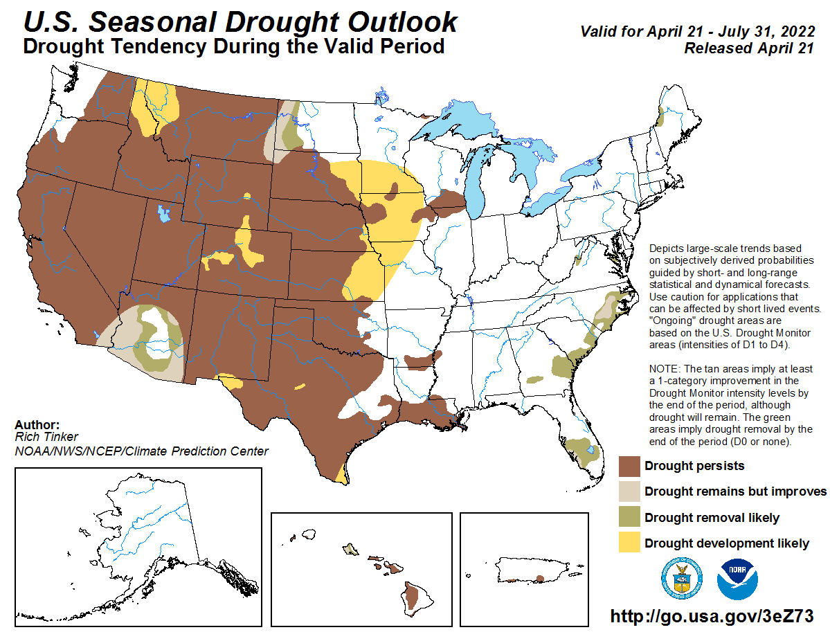
Meanwhile, drought in Colorado has remained mostly unchanged over the past three months. Eighty-three percent of the state is experiencing moderate or worse drought – with only the metro area and parts of the Western Slope seeing abnormally dry conditions. Most of the western half of the state is seeing moderate or severe drought, according to last week’s U.S. Drought Monitor release.
Tattered Cover and Water Education Colorado are pleased to present this virtual event with Paolo Bacigalupi on May 11th at 6pm. This will be live streamed via YouTube Live. A link to view the stream will be emailed to you upon registration…
PAOLO BACIGALUPI is a Hugo, Nebula, and Michael L. Printz Award winner, as well as a National Book Award finalist. He is also a winner of the Theodore Sturgeon Memorial Award, the John W. Campbell Award, and a three-time winner of the Locus Award. His short fiction has appeared in The Magazine of Fantasy & Science Fiction, Asimov’s Science Fiction Magazine, and High Country News. He lives with his wife and son in western Colorado, where he is working on a new novel.
Flaming Gorge Reservoir July 2020. Photo credit: Utah DWR
Click the link to read the article on the 9News.com website (Cory Reppenhagen). Here’s an excerpt:
The Upper Basin Drought Response Operations Agreement (DROA) identifies an elevation of 3,525 feet as a target level to take action because a level of 3,490 feet would threaten the infrastructure and hydropower resources at Glen Canyon Dam.
“We are concerned, we are watching,” said Becky Mitchell, the director of the Colorado Water Conservation Board and Governor Polis’s representative on the Upper Colorado River Commission. “There are significant challenges facing the Colorado River system.”
She said that two unprecedented measures are being taken to help prevent Lake Powell from hitting that critical level of 3,490 feet. One, which has already been approved, is to move an unprecedented 500,000 acre-feet of water out of the Flaming Gorge Reservoir in northern Utah and southern Wyoming, into Lake Powell over the next 12 months. A second proposal, which [was approved by the basin states this week], is to withhold nearly 480,000 acre-feet of water that is scheduled to be released from Lake Powell and sent to Lake Mead.
To address unprecedented drought conditions and provide long-term protection of Southern Nevada’s primary water storage reservoir—Lake Mead— the Southern Nevada Water Authority constructed a third drinking water intake capable of drawing upon Colorado River water at lake elevations below 1,000 feet (above sea level). Intake No. 3 ensures Southern Nevada’s access to its primary water supply if lake levels continue to decline due to drought conditions. It also protects municipal water customers from water quality issues associated with declining lake levels. Photo credit: Southern Nevada Water Authority
Click the link to read the article on the Nevada Independent website (Daniel Rothberg). Here’s an excerpt:
The country’s largest man-made reservoir, Lake Mead, has dropped to such a historically low level that Las Vegas water officials have completed the process of turning on a pump station that will allow Southern Nevada to retrieve water, even under extreme conditions. The move — to turn on the pump station full bore — is an indication of how low Lake Mead has fallen over the past decade and serves as a bulwark against the possibility of Las Vegas losing physical access to its water as regional issues on the Colorado River become increasingly dire…
Intake #1 exposed. Photo credit: SNWA
Lake Mead is about 30 percent full, and the amount of water stored at the reservoir has ticked down over the last month. As of Tuesday, Lake Mead’s elevation sat at about 1,056 feet above sea level, roughly 163 feet below the reservoir’s maximum capacity. For the Southern Nevada Water Authority, that’s a notable number because the agency’s first pumping station — which removes water from the reservoir and siphons it off to customers in the valley — becomes inoperable when Lake Mead drops below 1,050 feet above sea level…
Las Vegas Lake Mead intake schematic, courtesy SNWA.
The water authority’s second pumping station allows for the retrieval of water up to 1,000 feet above sea level. But the third pumping station, the one fully turned on this month and known as the “low lake level pumping station,” allows Las Vegas officials to pump out water from even deeper, with the potential to access water when other Southwest cities cannot. Doa Ross, the water authority’s deputy general manager for engineering, said the pump station, which links to a third intake, or “third straw,” at the lake, will now serve as the city’s main pump…
At 895 feet above sea level, Ross said Lake Mead water can no longer pass through the Hoover Dam, a scenario that water managers refer to as “dead pool.” But because Las Vegas’s primary pump now extends to about 875 feet above sea level, the city will still be able to access water. In effect, Las Vegas watched the unfolding crisis on the river and prepared for the worst.
Pat Mulroy, a senior fellow at the University of Nevada, Las Vegas’ Boyd School of Law and the former longtime general manager of the Southern Nevada Water Authority, is an advocate for extensively rethinking how the Colorado River is managed. (Image: University of Nevada, Las Vegas’ Boyd School of Law)
“We invested $1.5 billion in the third intake and the low-level pumping station for a reason,” John Entsminger, the water authority’s general manager said in a recent interview. “We knew very well that this day could come and if lake elevations continue to decline, the people of Las Vegas can take comfort in the fact that they are the most water-secure city in the desert Southwest.”
[…]
Brad Udall: Here’s the latest version of my 4-Panel plot thru Water Year (Oct-Sep) of 2021 of the Colorado River big reservoirs, natural flows, precipitation, and temperature. Data (PRISM) goes back or 1906 (or 1935 for reservoirs.) This updates previous work with @GreatLakesPeck.
“This isn’t a drought any more,” said Brad Udall, a senior water and climate research scientist at Colorado State University. “Let’s not fool ourselves. It’s aridification. It’s the long-term drying and warming of the American West. And it’s going to continue, and it’s going to get worse.”
Only about 10 days after a powerful, winter-like storm struck the northern Plains, a similar system delivered another round of heavy precipitation and high winds. With the more recent storm, which primarily unfolded on April 22-23, heavy snow was focused across a smaller area, primarily blanketing western North Dakota, southeastern Montana, northwestern South Dakota, and portions of Wyoming. Meanwhile in the Red River Valley, heavy rain falling on partially frozen soils resulted in extensive flooding, especially north of Fargo, North Dakota, with runoff further enhanced by melting snow. Farther south, high winds again raked the central and southern Plains and the Southwest, resulting in blowing dust and fast-spreading wildfires. Across the southern High Plains’ hardest-hit drought areas, hot, windy weather sapped any remaining soil moisture and further stressed rangeland, pastures, and winter grains. Meanwhile, a few severe thunderstorms dotted the Plains and upper Midwest, leading to localized wind and hail damage. The greatest concentration of severe weather occurred on April 22 from South Dakota to northern Texas. In contrast, little or no precipitation fell during the week across the nation’s southwestern quadrant, leading to further drought intensification. As the drought-monitoring period ended (on the morning of April 26), a significant rain event was winding down across parts of southern and eastern Texas…
For the second week in a row, significant precipitation fell across parts of the northern Plains. Heavy snow blanketed western North Dakota, southeastern Montana, northwestern South Dakota, and parts of Wyoming, helping to further improve soil moisture. Still, by April 24, the U.S. Department of Agriculture reported topsoil moisture was rated at least one-half very short to short in each of the region’s states except North Dakota (26% very short to short, down from 39% the previous week). Elsewhere in the region, topsoil moisture rated very short to short ranged from 53% in South Dakota to 82% in Nebraska. Still, parts of the eastern Dakotas have become very wet, with runoff enhanced by melting snow and rain falling on partially frozen soils. Following the latest storm, moderate to major flooding developed in the Red River Valley, extending northward from near Grand Forks, North Dakota. By April 27, the Red River at Oslo, Minnesota, was more than 11.5 feet above flood stage and less 10 inches below the April 2009 high-water mark. Farther south, however, drought continued to gradually expand and intensity, amid windy, mostly dry conditions and rapid temperature fluctuations. In Nebraska, daily-record highs for April 22 soared to 91°F in Sidney and 97°F in Valentine and North Platte, followed just 3 days later by a daily-record low of 14°F in Sidney. By April 24, more than one-quarter of the winter wheat in each of the region’s major production states was rated in very poor to poor condition, led by Colorado (47%) and Kansas (36%)…
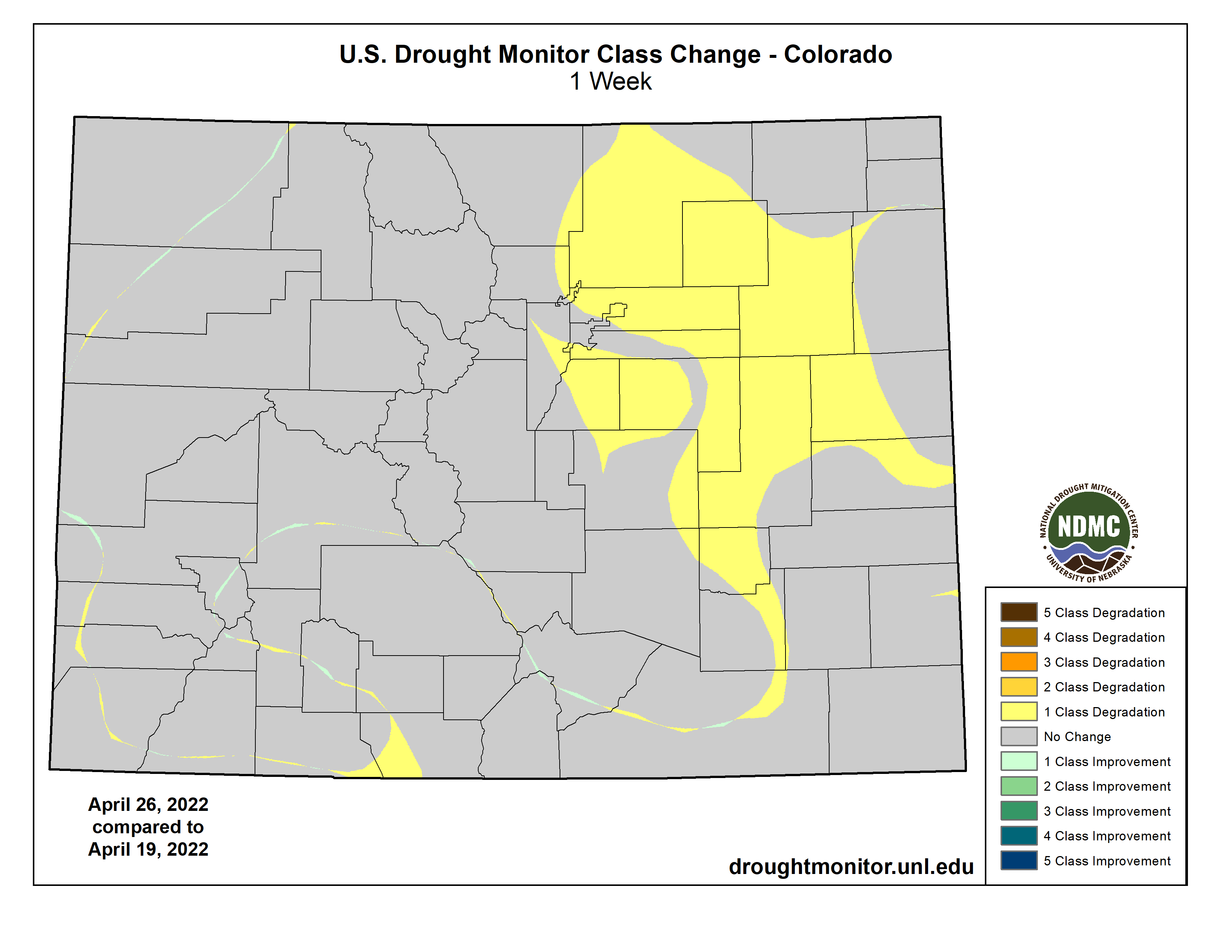
Colorado Drought Monitor one week change map ending April 26, 2022.
Conditions were nearly identical those observed the previous week, with beneficial precipitation falling across the northern tier of the region and windy, dry weather dominating the Southwest. Given the Southwest’s low humidity levels, high winds, and drought-cured vegetation, two active wildfires—the Hermits Peak and Cooks Peak Fires—charred more than 50,000 acres of vegetation apiece in northeastern New Mexico. Northeast of Flagstaff, Arizona, the Tunnel Fire—ignited on April 17—scorched nearly 20,000 acres of vegetation and destroyed more than 50 structures. At times, impressively high winds raked the Southwest, raising dust and fanning flames. On April 22 in New Mexico, wind gusts in Gallup, Farmington, Las Vegas, and Raton were clocked to 70, 72, 73, and 80 mph, respectively. By April 24, according to the U.S. Department of Agriculture, New Mexico led the nation—tied with Texas—with topsoil moisture rated 86% very short to short. By the 26th, Tucson, Arizona, reported a daily-record high of 100°F—only the fourteenth observance of triple-digit heat on record during April in that location. Tucson’s only earlier readings of 100°F or higher occurred on April 19-21, 1989, and April 22-23, 2012. Deterioration was common across the Southwest, with extreme to exceptional drought (D3 to D4) broadly expanding in New Mexico and moderate to severe drought (D1 to D2) increasing in coverage across parts of Arizona and Colorado. Farther north, however, periods of precipitation continued from northern California and the Pacific Northwest to the northern Rockies. Changes in the Northwestern drought depiction, although fewer than those noted the previous week, were driven by factors such as improving water-supply prospects and increasing topsoil moisture. In Oregon, topsoil moisture rated very short to short improved from 47 to 36% during the week ending April 24…
The region remained split between critically dry conditions on the High Plains of Oklahoma and Texas and wet conditions just to the east. During the drought-monitoring period, the axis of heaviest rain stretched from northeastern Texas into northern Arkansas, with additional rainfall maxima in parts of southern and eastern Texas. Those rains led to targeted, one-category improvements in the drought depiction, with highly localized two-category changes. Meanwhile, the region’s driest areas continued to experience deteriorating conditions, including a broad expansion of exceptional drought (D4), amid periods of extreme heat, high winds, and blowing dust. Temperatures reached 100°F—mainly on April 20 and 21—in parts of the south-central U.S., extending to the Texas-Oklahoma border near Childress (100°F on April 21) and Wichita Falls, Texas (99°F on April 20). In western Texas, peak gusts April 22 were clocked to 73 mph in Lubbock and Dalhart. On April 24, Texas led the country in several drought-related categories, according to the U.S. Department of Agriculture, including topsoil moisture rated very short to short (86%, tied with New Mexico) and winter wheat rated in very poor to poor condition (78%). On the same date, nearly half (48%) of Oklahoma’s wheat was rated very poor to poor…
Looking Ahead
The threat of frost and sub-freezing temperatures will linger at least into Friday in parts of the Great Lakes and Northeastern States. Meanwhile, a disorganized storm system will cross the western U.S. before intensifying on April 29-30 over the nation’s mid-section. With the storm’s path across the central Plains and upper Midwest, rainfall could reach 1 to 3 inches in the north-central U.S., with some of the highest amounts expected on Friday in the Dakotas. Meanwhile, windy, dry weather in the nation’s southwestern quadrant will lead to additional drought and wildfire concerns. Late in the weekend, however, portions of the southern Plains may experience some drought relief.
The NWS 6- to 10-day outlook for May 3 – 7 calls for the likelihood of near- or below-normal temperatures across the North and Far West, while warmer-than-normal weather will prevail from the Four Corners States eastward to the middle and southern Atlantic Coast. Meanwhile, near- or above-normal precipitation across most of the country should contrast with drier-than-normal conditions in the upper Great Lakes region and parts of the Southwest.
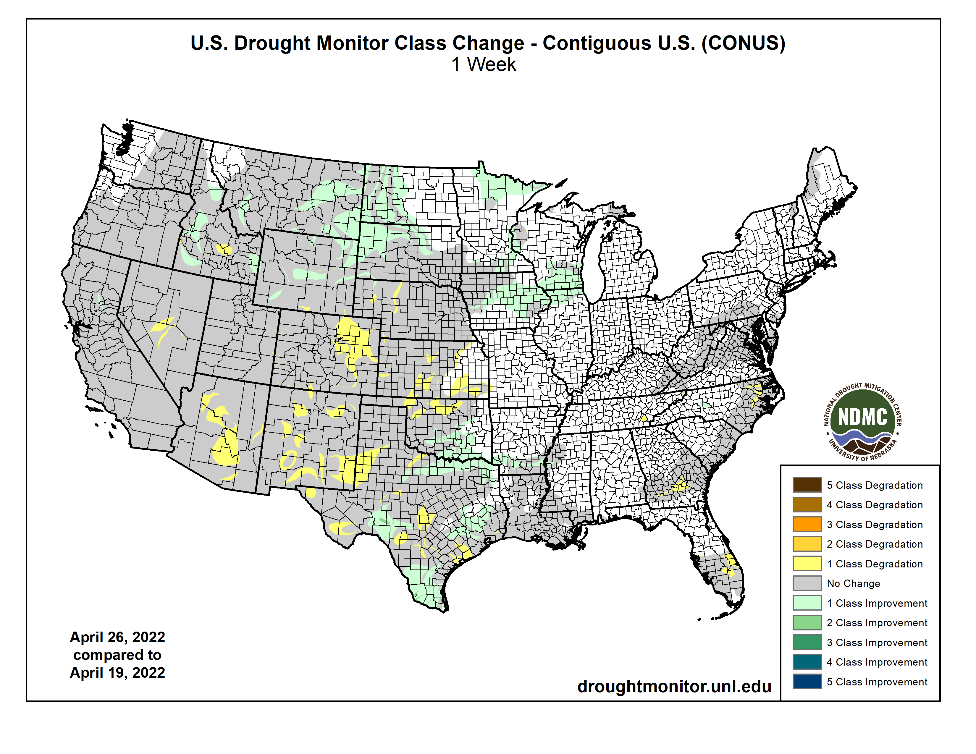
US Drought Monitor one week change map ending April 26, 2022.
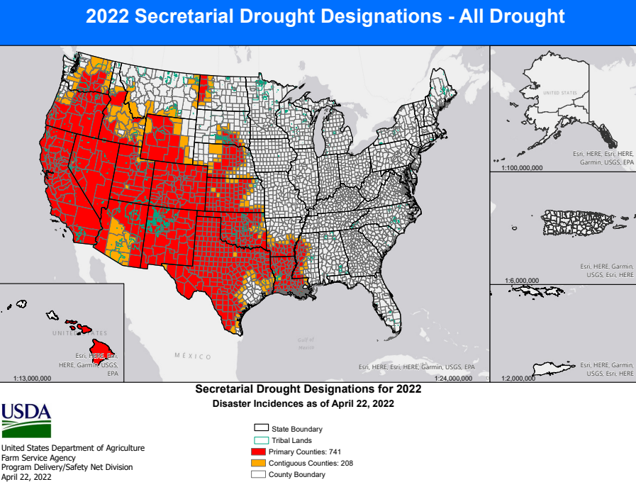
Click the link to read the release on the USDA website:
This Secretarial natural disaster designation allows the United States Department of Agriculture (USDA) Farm Service Agency (FSA) to extend much-needed emergency credit to producers recovering from natural disasters through emergency loans. Emergency loans can be used to meet various recovery needs including the replacement of essential items such as equipment or livestock, reorganization of a farming operation or the refinance of certain debts. FSA will review the loans based on the extent of losses, security available and repayment ability.
According to the U.S. Drought Monitor, these counties suffered from a drought intensity value during the growing season of 1) D2 Drought-Severe for 8 or more consecutive weeks or 2) D3 Drought-Extreme or D4 Drought-Exceptional.
Impacted Area: Colorado
Triggering Disaster: Drought
Application Deadline: Dec. 8, 2022
Primary Counties Eligible:
Click the image for a larger view.
Contiguous Counties Also Eligible:
Arizona: Apache Kansas: Cheyenne, Greeley, Hamilton, Morton, Sherman, Stanton, Wallace Nebraska: Chase, Cheyenne, Deuel, Dundy, Kimball, Perkins New Mexico: Colfax, San Juan, Union, Rio Arriba, Taos Oklahoma: Cimarron Utah: Daggett, Grand, San Juan, Uintah Wyoming: Albany, Carbon, Laramie, Sweetwater
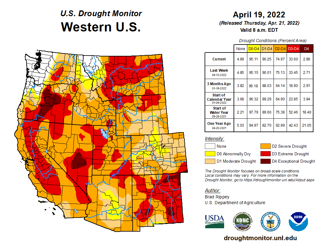
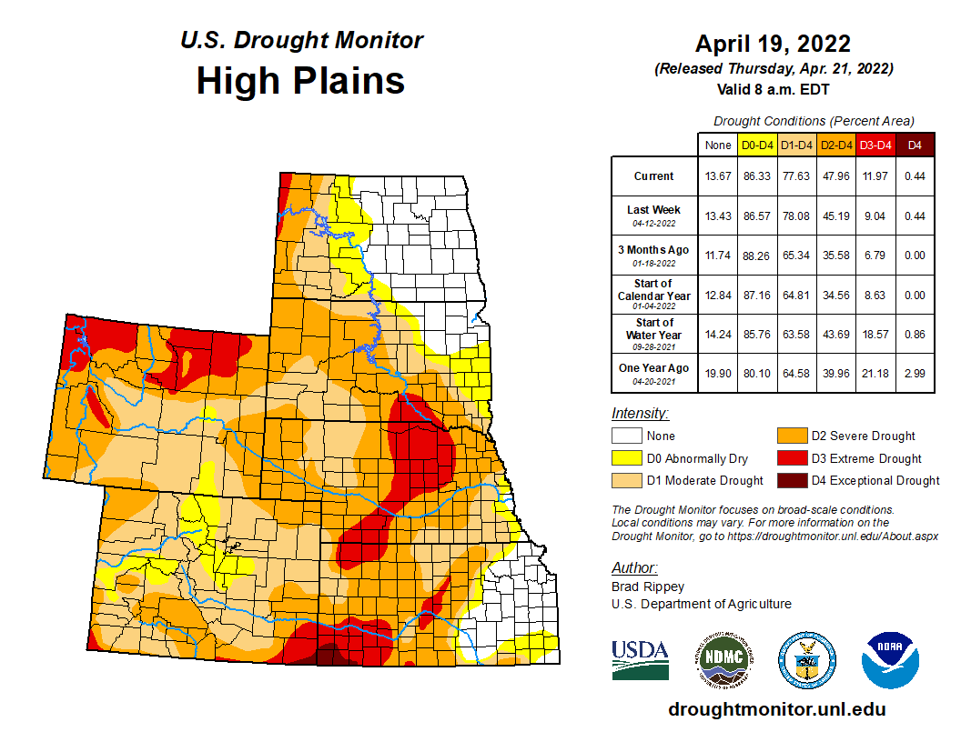
West Drought Monitor map April 19, 2022.High Plains Drought Monitor map April 19, 2022.
It's official – the top of Intake No. 1 is now visible and the low lake level pumping station is now operational. The new low lake pumping station was completed in 2020 to ensure the delivery of high-quality water in Southern Nevada. Learn more at https://t.co/o0rJqlXiFXpic.twitter.com/vPqULBlrCb
— Southern Nevada Water Authority (@SNWA_H2O) April 26, 2022
Las Vegas Lake Mead intake schematic, courtesy SNWA.SNWA intake #1 exposed April 2022. Photo credit: SNWAIntake #1 exposed. Photo credit: SNWAIntake #1 exposed. Photo credit: SNWA
Rio Grande and Republican River would use funds to meet state groundwater sustainability, interstate compact compliance targets
COLORADO is moving toward putting $60 million into a new groundwater compact compliance fund for the Rio Grande and Republican River basins created and funded through a state senate bill drafted and championed by state Sen. Cleave Simpson of Alamosa.
The bill, Senate Bill 22-028, creates the Compact Compliance Fund that would be administered by the Colorado Division of Water Resources and would receive an appropriation of $60 million from Colorado’s share of federal COVID relief money from American Rescue Plan funding.
The bill, co-sponsored by Sen. Jerry Sonnenberg of Sterling, originally only established the fund, and then an amendment unanimously adopted Thursday by the Colorado House Agriculture, Livestock, and Water Committee added $60 million into it. The bill next will be heard by the House Appropriations Committee.
“Given the unanimous votes every step of the way, so far, I am hopeful the bill with the appropriation will become law in the next week or two,” Simpson told Alamosa Citizen. “The timing of the availability of federal dollars and the growing sense of urgency in both basins created a unique opportunity that will serve both of these communities well. Still some work to do, but things look very promising for both of these Colorado communities.
Rio Grande and Pecos River basins. Map credit: By Kmusser – Own work, Elevation data from SRTM, drainage basin from GTOPO [1], U.S. stream from the National Atlas [2], all other features from Vector Map., CC BY-SA 3.0, https://commons.wikimedia.org/w/index.php?curid=11218868
If the Compact Compliance Fund is adopted by the Colorado Legislature it would pay for efforts to meet groundwater sustainability targets in the Rio Grande Basin and interstate compact requirements for the Republican River Basin. Each basin would get an earmark of $30 million to pay for efforts like retiring groundwater wells and other conservation and water sustainability measures. The goal would be to spend all $60 million within the time constraints put on federal COVID dollars, whether it’s a 50-50 split or not.
The Republican River basin. The North Fork, South Fork and Arikaree all flow through Yuma County before crossing state lines. Credit: USBR/DOI
The threat to livelihood for farmers and ranchers and economic disaster for the regions tied to irrigated agriculture in the Rio Grande and Republican River basins was made loud and clear in the House Agriculture, Livestock, and Water Committee.
“These farmers and ranchers have done everything they possibly can,” said Marisa Fricke, one of the Rio Grande Water Conservation District’s program managers. “They grow produce for us and hay for our cattle.”
Farmers and ranchers in both basins have levied property taxes on themselves through the water conservation districts to pay for their efforts to help the Rio Grande and Republican River meet groundwater sustainability and interstate compact compliance goals set by the state. It has meant fallowing of crop fields, permanently retiring irrigated acreage, taking groundwater wells off line either temporarily or permanently, and compensating farmers and ranchers for their efforts to help offset loss from less irrigated acres.
State Reps. Marc Catlin and Dylan Roberts made impassioned pleas for including $60 million of the ARPA money into the compact compliance fund during their presentation of the bill in the House Ag committee. Both are House sponsors of the bill.
“This is an opportunity with these funds to say, ‘We’re with you,’” said Catlin of the risk farmers and ranchers take their sacrifices to address compact and sustainability issues on the Republican River.
“This is a great bill for the San Luis Valley and Republican River Basin,” said Heather Dutton, district manager of the San Luis Valley Water Conservancy District. “Colorado through COVID relief bills provide a once in a lifetime opportunity to invest in our communities. The imbalance between water use and supply is a critical issue facing Colorado and especially the basins highlighted in this legislation.”
Farmers in the San Luis Valley are looking to take even more drastic steps in their efforts to meet state targets on groundwater pumping and recharging of the Upper Rio Grande Basin’s unconfined aquifer. In Subdistrict 1 of the Rio Grande Water Conservation District, farmers are facing a new proposed amendment to the subdistrict’s Plan of Water Management that would tie the level of groundwater pumping allowed to the natural surface water of the property. Some farms in the subdistrict do not have natural surface water, in which case they would have to purchase water credits from a neighboring farm or pay an overpumping fee of $500 per acre-foot.
This concept keeps the system in balance by replenishing what has been withdrawn from the aquifer with surface water and allows the community within Subdistrict No.1 to work together through the exchange and sale of credits. In the event that more groundwater is withdrawn from the aquifer and not replenished an overpumping fee of $500 per acre-foot would be assessed, according to the proposed amendment to the subdistrict’s water management plan. Money collected by the conservation district from an over pumping charge would come back to the Subdistrict 1 community in the form of payments towards enrolling in water conservation programs, according to Fricke.
“For over a decade farmers and ranchers have worked to meet sustainability levels and have taxed themselves assessments for waters taken out of the aquifer,” Fricke told House ag committee members.
Eventually the water conservation districts would establish guidelines and the state Division of Water Resources would administer drawdowns of the fund. In the unlikely chance Rio Grande and Republican River water managers didn’t spend all $60 million, the money would revert to the division of water resources.
Future state appropriations to Compact Compliance Fund would hinge on executive and legislative budget priorities.
Pawnee, a coal-burning plant near Brush, in northeastern Colorado, would be converted to natural gas no later than 2026, according to a proposal submitted to state regulators yesterday., It’s located a mile from where this writer and photographer emerged into the world. Photo/Allen Best
Click the link to read the article on the Big Pivots website (Allen Best):
A settlement agreement proposes an earlier coal plant retirement and a way way to evaluate need for new natural gas plants. It also punts some key decisions.
An agreement filed Tuesday with state regulators proposes a sharper, faster pivot by Colorado’s largest electrical utility from coal to renewables and alternative technologies.
The settlement agreement filed by Xcel Energy and other parties calls for retirement of Comanche 3, the state’s youngest and most powerful coal plant, “no later than” Jan. 1, 2031. Retirement could actually occur sooner.
As for new natural gas generation, the agreement calls for a new measuring stick: How cost-effective can the gas plant be if it operates only 25 years?
This could potentially result in Xcel Energy reducing carbon emissions from its electrical generation 88% by 2030 as compared to 2005 levels. As of 2021 Xcel’s electrical generation in Colorado was 39% carbon free.
But the proposal would also kick some major decisions down the road to 2024 and 2025. “The modeling and technologies need just a little more time to improve,” said Gwen Farnsworth, managing senior policy advisor in Colorado for Boulder-based Western Resource Advocates.
Among the items almost certain to be taken up in 2024 are questions of whether new programs and business models can be used to configure demand for electricity to better match supplies. For example, can batteries of electric cars be charged during the middle of night, when wind turbines in eastern Colorado most reliably whirl? Can peak demand be shaved more on hot summer afternoons? Such strategies and new technologies could reduce need for new generation, both fossil and renewables,
Those decisions include when exactly Comanche 3 needs to close. When the $1 billion plant opened in 2010, it was projected to operate until 2070. It has had a troubled history, a largely unreliable source of electricity with massive amounts of debt remaining. The 750-megawatt plant has been idled – again – since January, with no certain date for reopening.
Noting that lack of reliability, two of the three PUC commissioners in March indicated that they saw no good reason for the plant to remain operational beyond 2029.
Xcel last year proposed continuing operations to 2040, then agreed to a 2034 closing. This moves up the no-later-than date to the end of 2030.
“No-later-than is a key phrase, because it allows for flexibility and even improving the results of this settlement over time,” said Farnsworth. She said the accelerated retirement of Comanche 3 by just four years will save Xcel ratepayers up to $39 million.
And having Comanche off-line this year has helped save money because otherwise production from wind farms and other renewable generation would have been curtailed.
As for new natural gas, Xcel originally proposed 1,300 megawatts of “dispatchable” resources, meaning natural gas or other fossil fuels. Dispatchable resources can – at least in theory – be turned on quickly to meet demand. In practice, it’s more complicated. See Comanche 3.
How much natural gas?
Some of Xcel’s plans for natural gas remain. The coal-burning Pawnee Power Plant near Brush, about 90 miles northeast of Denver, is to be converted to natural gas no later than January 2026. Still in question is how much additional natural gas generation Xcel will acquire.
Xcel could still propose new burn natural gas plants to go on line in 2030, for example, but they would have to cease producing emissions by 2050.
But the settlement agreement also will result in new modeling that the Sierra Club’s Anna McDevitt says will allow battery storage coupled with renewable generation to better compete with natural gas in giving Xcel the confidence it can meet demands. Previous modeling used what the Sierra Club believes were flawed assumptions that favored natural gas.
“There is much in the settlement that will result in less likelihood of building new gas plants,” she said.
Xcel, in a presentation to investors in November 2021, estimated its Colorado division, would spend $9.9 billion from 2022 through 2026, not quite two-thirds for electric distribution and transmission but almost a quarter for natural gas.
Another major component of the plan calls for Xcel to continue property tax payments to Pueblo and Pueblo County districts from 2031 through 2040, the previous retirement date.
The proposal would have Xcel continue tax payments to Pueblo and Pueblo County until 2040.
Holy Cross Energy, the electrical cooperative serving the Vail and Aspen areas, owns 8% of Comanche 3. That translates to a potential 60 megawatts of production.
The agreement specifies that Holy Cross will be able to continue to use Xcel Energy’s transmission lines from eastern Colorado for an equal amount of electrical production, either from the resources owned by Holy Cross or from the new generating resources being brought on-line by Xcel in coming years.
Xcel’s plans for new generation, to be determined by competitive bidding, are estimated to include 2,400 megawatts of new wind, 1,600 megawatts of large-scale solar, 400 megawatts of energy storage, and nearly 1,200 megawatts of distributed solar resources.
“In a way, we are held harmless by the early retirement” of Comanche 3, said Bryan Hannegan, the chief executive of Holy Cross.
Holy Cross is currently projected to pay off its portion of the Comanche 3 debt in 2042.
Sedalia-based CORE Electric Cooperative, the state’s largest electrical cooperative, which serves Castle Rock and other suburban and exurban communities on the south flanks of metropolitan Denver, owns 25% of Comanche 3.
Hannegan and many others credited Xcel with a major achievement in getting a diverse set of parties – Boulder, Pueblo and other cities, as well as labor and business groups, environmental organizations, and still others – to come to a compromise.
Release of the agreement was accompanied by press releases from many organizations with a chorus of hosannahs.
“This agreement is a significant step toward meeting Colorado’s climate goals,” said Will Toor, chief executive of the Colorado Energy Office. “We’re so proud to lead the charge on reducing carbon emissions in Colorado,” said Alice Jackson, president of Xcel’s Colorado division. The Natural Resources Defense Council’s Noah Long also saluted a future of “savings for Xcel Energy customers and cleaner skies for Colorado.”
Farnsworth, of Western Resource Advocates, offered similar praise, but also pointed to a strong motivation: “I think the parties all made it possible because there’s a common understanding of the urgency of addressing climate change and also the urgency of moving this resource planning process forward in time to benefit from the federal tax credits for wind and solar.”
That, she added, made everybody want to reach compromise and avoid litigation.
The key word used by many was “flexible.”
Forward movement, but…
Not all were equally enthused. “Any date for shutting Pueblo unit 3 that isn’t 2022 is the wrong date,” said Leslie Glustrom of Boulder-based Clean Energy Action, referring to Comanche 3. “The climate crisis now clear to everyone.”
The Colorado Renewable Energy Society policy committee members were miffed that the social cost of methane was not used in the agreement as they had advocated.
“A big move forward, but there are pieces missing,” said the group’s Laurent Meillon. He charged that the plan still favors Xcel building generating facilities – that it can then use to justify higher rates to customers than necessary.
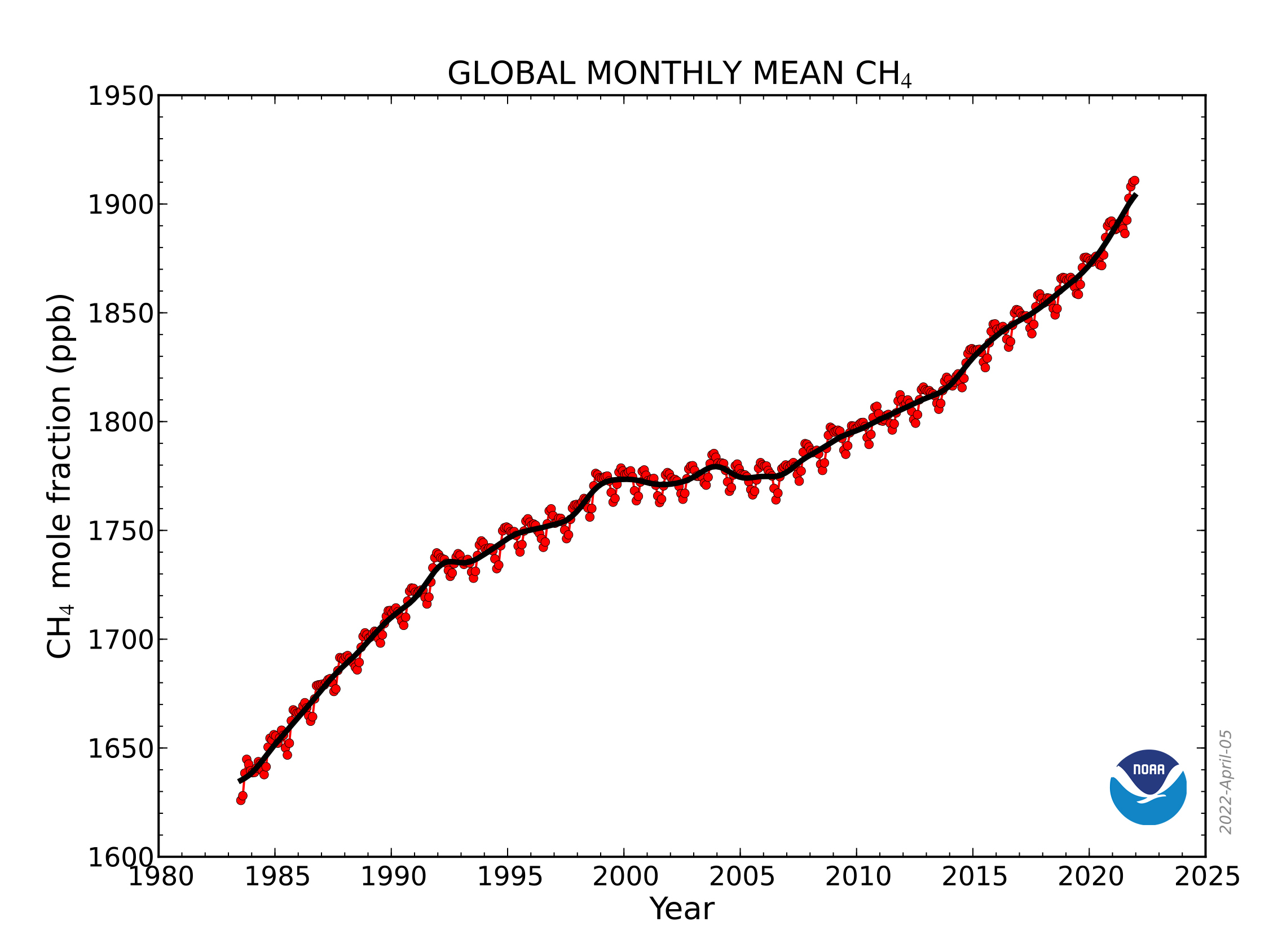
CH4 trend: This graph shows globally-averaged, monthly mean atmospheric methane abundance determined from marine surface sites since 1983. Values for the last year are preliminary. (NOAA Global Monitoring Laboratory)
“Xcel is orienting itself toward the construction of unnecessary gas plants, thus maximizing its investments and profits, right before it becomes entirely too obvious that only renewables and efficiencies are worthy of more investments. A repeat of its profitable coal mistakes, despite the current early coal closures with decades left to amortize those stranded assets,” he wrote in an e-mail.
CRES members, Glustrom and others say that Xcel must more aggressively pursue strategies that shave peak demands. Others involved in the agreement said they believe that those programs will become a central component of discussions in the middle of this decade. Xcel is beginning an update this summer of the thinking behind its programs.
All in all, how might this settlement be seen in a broader context – say, the United States? Farnsworth offers what must be considered a hometown view but one worth considering.
“Colorado might be on a smaller scale than some other states, but Xcel and this settlement are really on the leading edge.”
Solar installation in the San Luis Valley. Photo credit: Western Resource Advocates
Western Resource Advocates signed on to a revised settlement agreement filed today in Xcel Energy’s Electric Resource and Clean Energy Plan proceeding before the Colorado Public Utilities Commission. The new settlement includes accelerated dates for retiring the Comanche 3 coal unit, helps avoid building unnecessary and potentially stranded new fossil gas generation, and establishes commitments to achieve interim carbon emission reductions in 2024 and 2027.
“If approved, this settlement secures the next stage of Colorado’s energy transition, ensuring commitments from Xcel to reduce its harmful fossil-fuel emissions that contribute to climate change,” said Gwen Farnsworth, Western Resource Advocates’ managing senior policy advisor in Colorado. “The earlier date for retiring Comanche 3, plus cutting the assumed lifetime for any new fossil gas generation and establishing interim targets for reducing carbon emissions, will all help Colorado reach its climate goals. Important provisions also extend community assistance to the Pueblo community for 10 years and will help in the transition to new economic opportunities as the coal-fired Comanche unit closes.”
These are all key improvements to the settlement WRA has advocated for during the commission proceeding on Xcel’s plan. WRA opposed a previous version of the settlement signed by other parties late last year. Specifically, the new settlement calls for Xcel to:
Retire Comanche 3 by January 1, 2031 — four years earlier than the original settlement, which will avoid an additional 3.5 million tons of carbon emissions compared to the original settlement filed in November and will cut toxic local air pollutants in Pueblo;
Commit to interim reductions in carbon dioxide emissions, with targets of a 50% reduction by 2024 and 65% by 2027, compared with the utility’s 2005 levels;
Cut the modeled lifetime for any new fossil gas generation to 25 years; and
Expand Xcel’s Just Transition Plan, by extending the community assistance benefits for Pueblo to 10 years.
The settlement overall will provide more than 17 million tons of carbon dioxide emissions reductions. Reducing these fossil-fuel emissions will help curb the harmful effects of climate change. The Comanche generating station is also responsible for over 80% of all toxic chemicals released into the surrounding community of Pueblo.
Photo credit: Allen Best/The Mountain Town News
Several provisions in the revised settlement reduce the utility’s expected future reliance on fossil-fuel gas generation. According to the Intergovernmental Panel on Climate Change, reducing methane emissions from fossil-fuel gas is one of the biggest and fastest strategies for slowing climate change.
The Xcel settlement today follows the utility’s February 2021 announcement of its Clean Energy Plan committing to achieve an 85% reduction in carbon emissions and 80% renewable energy generation by 2030, as well as 100% clean energy by 2050. A 2019 Colorado law requires Xcel to reduce its emissions by 80% below 2005 levels by 2030. In 2019, the Colorado Legislature also passed House Bill 1261, requiring the state to reduce its economy-wide greenhouse gas emissions by 50% below 2005 levels by 2030 and 90% by 2050.
The amount of information Colorado water managers have about the state’s crucial snowpack is poised to swell exponentially over the next two years.
In mid-March, the Colorado Water Conservation Board, which aims to help water managers conserve, develop, protect and manage Colorado’s water, approved a $1.9 million grant to help pay for a plane stuffed with high-tech equipment to fly over Colorado’s mountains and measure the snowpack below.
Denver Water used Airborne Snow Observatory, or ASO, flights in 2019 and 2021 to gather data on the snowpack above Dillon Reservoir, the utility’s largest reservoir.
The information helps forecast how much water is expected to come tumbling down the mountain during the spring runoff — a critical time for collecting and storing water for the utility’s 1.5 million water users across metro Denver.
“Getting more and better information about the snowpack improves the accuracy of our spring runoff forecasts, and that helps us in many ways,” said Nathan Elder, water supply manager for Denver Water.
“With better information, we have a better idea of how the spring runoff could impact the environment and recreation, and whether we might have to go on watering restrictions during the summer. It also helps inform us on how we should manage all of water resources,” he said.
This year, in addition to getting ASO data about the snow in the Blue River Basin above Dillon, Denver Water also will get information about the snowpack in the Fraser, Granby and Willow Creek watersheds. Flights are scheduled for April and May, weather permitting.
The blue areas in the map above are where the Airborne Snow Observatory flights are scheduled to collect information about the snowpack in 2022. The light tan areas will be flown this summer and fall to collect baseline information about the ground when it is free of snow. Image credit: Lynker.
Based on NASA-developed technology, LiDAR equipment carried by the ASO planes use beams of light to measure the depth of the snow across entire watersheds and capture reflections from the frozen surface. Data from the flights over the snow-covered watersheds is compared to data collected when the same watershed is free of snow.
The resulting information from comparing the two sets of data tells water managers how much snow is on the ground and how much water it holds, augmenting data collected from SNOTEL sites, which also measure snowpack at selected sites, and decades of historical statistics.
The path of an ASO flight over the Blue River Basin, which flows into Dillon Reservoir, on Monday, April 18, 2022. Image credit: FlightAware.
“We see these ASO flights as a climate adaptation strategy,” said Taylor Winchell, a water resource engineer at Denver Water who works on climate change adaptation and water supply planning issues.
“As our snowpack changes with the changing climate, being better able to measure that snowpack becomes more important as more snow falls as rain, as the timing of the spring melt changes and as snow falls at ever-higher elevations because of warming. We can’t rely as much on historical snowpack datasets to understand the new snowpack reality.”
Winchell worked with water managers throughout Colorado to develop support for the state grant and create a collective known as CASM, short for the Colorado Airborne Snow Measurement group, that grew to include members from federal, state and local government levels, academia, the recreation industry and agriculture industries, as well as local nonprofits and environmental advocacy organizations.
The ASO flight path over the Fraser River, Willow Creek and Granby watersheds on Tuesday, April 19, 2022. Due to a state grant, this is the first year that airborne data from these watersheds will be available for water managers to study. Image credit: FlightAware.
“We had 37 letters of support for the initiative. To have that many groups supporting a water project, that’s unprecedented for a water project in Colorado. It’s rare to see so many people agree on something — but more accurate data helps everyone,” Winchell said.
In addition to flights over snow-covered mountain watersheds, the grant also will help pay for flights over snow-free ground — collecting essential baseline information that can be used to expand the snow-on flight areas even more next year and beyond, Winchell said.
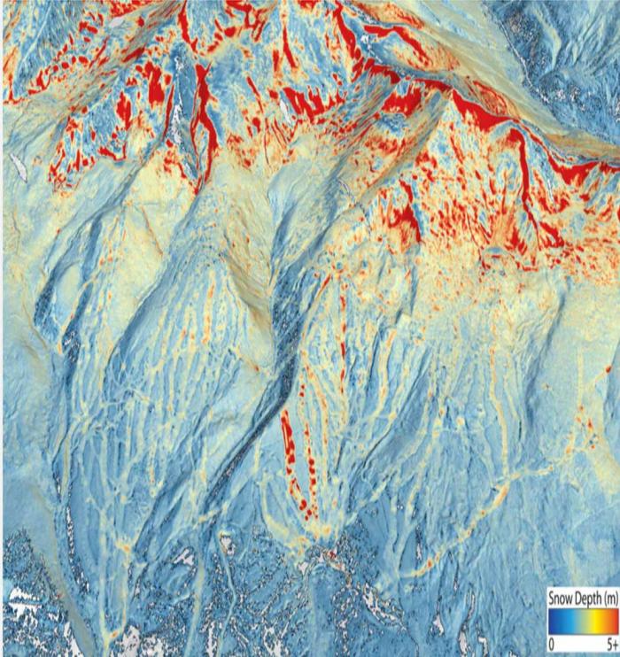
In this digitized image of the April 2021 snowpack above Dillon Reservoir, red splashes of color show where the snow was the deepest. The line of dots down the mountain is a ski run at Breckenridge Ski Resort where snow-making machines have added snow to the ground. Image credit: Airborne Snow Observatory Inc.
Work also will be underway this year to figure out how to continue the CASM program in the future, as the state’s grant is a one-year grant, Winchell said.
Denver Water managers are looking forward to seeing more ASO information about its watersheds, and also those throughout the state.
“How much snow falls outside our watersheds can affect Denver Water’s supply and operations just like the amount of snow that falls inside our watersheds,” Elder said.
“With this starting to become a statewide program, with data collected from more areas and that data being shared among the partners, it will help everyone better manage Colorado’s water supply.”
The Kortez dam below Seminoe Reservoir is a crucial part of a seven-reservoir water storage system on the North Platte River in Wyoming. (Dustin Bleizeffer/WyoFile)
Click the link to read the article on the WyoFile website (Dustin Bleizeffer):
April is typically when thousands of irrigators on the North Platte River — particularly along its tributaries — begin to divert spring runoff onto hayfields and crops, kicking off what they hope will be a productive growing season. Today, however, those with junior water rights are under new orders to curtail those critical early springtime diversions — a rare scenario that could prove costly for many farmers and ranchers in the state.
“When the water is coming, you’ve got one shot at it,” Upper North Platte Water Users Association Chairman Chris Williams said. Watching spring runoff flow downstream without tapping it is counterintuitive and frustrating for any ag producer, he added. “It has the potential to dry acres up.”
The “call,” or order, to restrict water diversions among North Platte River users with junior rights was initiated by the U.S. Bureau of Reclamation during the first week of April. The order, which is enforced by the Wyoming State Engineer’s Office, is set to expire at the end of the month. Water rights are prioritized based on a “first in time, first in right” doctrine. Those who gain rights to use water first have “senior” rights over those who gain water rights after them.
It’s unlikely the BOR will recommend extending the call, even if hydrological conditions and forecasts for the seven-reservoir North Platte River water storage system do not improve, according to Lyle Myler, acting manager for the Wyoming Area Office of the Bureau of Reclamation.
Ice crusts over the banks of the North Platte River near Casper in December 2021. (Dustin Bleizeffer/WyoFile)
“Our hope is that the curtailment of [junior] water rights will allow us to receive our share that’s allotted to us under our 1904 water rights, or as much as we can get,” Myler said.
Water users with junior rights on the Tongue River and its tributaries in northeast Wyoming are also on notice for similar, legally enforceable water conservation measures, following a call from Montana. Though no actual water diversion curtailment orders have resulted so far, those users will remain on notice until Montana officials remove the call, according to the Wyoming State Engineer’s Office.
‘Calls’ and climate
A call on a river or drainage system is a legal mechanism to order water conservation actions to help ensure minimum, legally required flows to users with senior rights to divert water — typically for irrigation. It can also apply to groundwater wells that pump from a drainage for municipal or industrial uses. In the event of a potential water shortage, those with junior rights can be ordered to forgo diverting water to help ensure that senior-rights holders downstream get their full allotment.
The BOR and water management authorities in Wyoming and Montana all cited low snowpack, persistent drought conditions and forecasts for lower-than-average precipitation for initiating the water conservation measures and notices.
“The Tongue River Basin has been experiencing drought conditions over the past year with below average winter snowpack and streamflow conditions,” according to an April 7 statement from the Wyoming SEO. “The North Platte River system has experienced multiple years of drought resulting in low reservoir storage carryover.”
Wyoming angler Jeff Streeter’s shadow casts over the shallow flow of the Encampment River — a tributary to the North Platte River — July 21, 2021. (Dustin Bleizeffer/WyoFile)
The conditions are consistent with climate trends that have pushed the statewide annual mean temperature upward by 2.2 degrees Fahrenheit from 1920 to 2020, according to National Oceanic and Atmospheric Administration data. The climate trend is also altering hydrological conditions in the state, such as lower snowpack and an earlier spring runoff season.
Despite current conditions and forecasts for lower-than-normal precipitation, however, it’s too early to know what spring may have in store, Wyoming State Engineer Brandon Gebhart said. If heavy spring snow and rain events do materialize, it could negate the need to curtail water diversions, he added.
The climate conditions contributing to the calls in Wyoming are likely to continue to force water managers to cooperate on conservation measures throughout the West, according to Utah Rivers Council Executive Director Zachary Frankel.
Clouds threaten rain over Pathfinder Reservoir, July 2019. (Dustin Bleizeffer/WyoFile)
“As our precipitation shifts from snow to rain, it is causing havoc on our water supplies, and that’s going to continue in coming years and decades,” Frankel said. “Although some climate model runs show increased precipitation — meaning more rain — it’s not likely to increase our total water supplies because of additional challenges from decreased soil moisture and a range of other challenges on the water demand side.”
Mandates
The BOR initiated the call on the North Platte River during the first week of April based on measurements and forecasts that indicate the seven-reservoir storage system might fill to only 950,000 acre-feet of water during this year’s “water season.” That’s below the Modified North Platte Decree’s call-triggering minimum of 1.1 million acre feet. The order applies to those with post 1904 water rights from the Wyoming-Colorado border to Guernsey Reservoir.
The Tongue River cascades over boulders near Dayton, September 2020. (Maggie Mullen/WyoFile)
In a separate action, the Montana Department of Natural Resources and Conservation issued a call on the Tongue River and its tributaries in Wyoming on April 1. The call is necessary to ensure that the Tongue River Reservoir in Montana fills this summer, and to otherwise hold Wyoming to account for legal obligations under the Yellowstone River Compact, according to Montana NRC Commissioner Anna Pakenham Stevenson.
Gebhart responded by notifying those with post-1950 water rights — junior rights — on the Tongue River and its tributaries that they may be ordered to curtail diversions at some point this summer. However, Gebhart and the agency’s Division II management that oversees the Tongue River drainage took issue with Montana’s initial assertions regarding forecasts for flows in the Tongue River.
Although both states acknowledged critical “data gaps,” the water storage and snowpack assessments initially cited by Montana should never have resulted in a call on the Tongue River, according to Gebhart. At the time, snowpack measurements for the drainage area measured more than 90% of the annual average. On April 19, it increased to 99%, according to a Natural Resources Conservation Service report.
Montana issued similar calls on the Tongue River in 2015 and 2016 based on more dire assessments than those cited this year, Gebhart said. But no orders to limit water diversions were necessary in response to either of those calls.
For now, both Wyoming and Montana continue to measure snowpack, water volumes and forecasts in the Tongue and greater Yellowstone River systems — hopeful that it might not be necessary to order irrigators to curtail normal irrigation practices, Gebhart said.
Dustin Bleizeffer is a Report for America Corps member covering energy and climate at WyoFile. He has worked as a coal miner, an oilfield mechanic, and for 22 years as a statewide reporter and editor primarily covering the energy industry in Wyoming. He served as MIT Environmental Solutions Initiative Journalism Fellow, John S. Knight Journalism Fellow at Stanford, communications director for Wyoming Outdoor Council and WyoFile editor-in-chief. He lives in Casper. You can reach him at (307) 267-3327, dustin@wyofile.com and follow him on Twitter @DBleizeffer.
Here’s the release from the Southeastern Colorado Water Conservancy District Board (Chris Woodka):
One newcomer is joining five returning members on the Southeastern Colorado Water Conservancy District Board of Directors. The appointments were made by a panel of District Judges in early April, and all six members were sworn into office Thursday, April 21, 2022.
Joining the Board is Matt Heimerich, 64, of Olney Springs, representing Crowley County. He will fill the four-year term of Carl McClure, who served for 17 years before retiring in 2022. The term will expire in 2025.
Heimerich is following in the footsteps of his father-in-law, Orville Tomky, who served on the Southeastern Board from 1988-2005.
Heimerich praised both McClure and Tomky at his first Board meeting for their contributions to Crowley County in dealing with the aftermath of water transfers of water from Crowley County that threatened to devastate the small rural county.
“Trying to bring a transmountain water diversion to the Arkansas Valley started in the 1920s and 1930s, and the need is as strong or stronger today,” Heimerich said. “What else can the Fryingpan-Arkansas Project deliver to meet the challenges faced by the people who live here? On the municipal side of the Project, what a difference it will make when the Arkansas Valley Conduit is completed.”
A New York native, Heimerich married Tomky’s daughter Karen in 1985, and began working in the family’s farming operation in 1987. The family continued farming after water from many of their neighbors’ farms had been sold to municipalities. He is a member of the Colorado Canal and Lake Meredith boards. He plans to make agricultural a priority while on the Southeastern Board.
Heimerich served from 1999-2011 as a Crowley County Commissioner, was on the Arkansas River Compact Administration board from 2007-2013, worked for the Palmer Land Trust in the Arkansas Valley office from 2014-2021, and is a member of the Water Education Colorado advisory board.
Reappointed, and serving four-year terms that expire in 2026 are:
Bill Long, President, a businessman from Las Animas, representing Bent County, first appointed in 2002.
Curtis Mitchell, Vice President, retired Fountain Utilities Director, representing El Paso County, first appointed in 2014.
Ann Nichols, Treasurer, retired General Manager of Finance for Colorado Springs Utilities, representing El Paso County, first appointed in 2006.
Alan Hamel, retired Executive Director of Pueblo Water, representing Pueblo County, first appointed in 1988.
Tom Goodwin, retired from the Forest Service and USDA, representing Fremont County, first appointed in 2011.
The Southeastern District was formed in 1958 to administer the Fryingpan-Arkansas Project, which was approved by Congress in 1962. The District includes parts of nine counties in the Arkansas River basin and brings water into the basin from the Fryingpan River basin on the western slope. There are a total of 15 Directors on the Board.
We’re into that time of year again where the CO2 at Mauna Loa is higher than last year’s peak – so we’re now seeing the highest CO2 ever recorded and for at least 2 million years. Data and graphics from – https://t.co/pEcJRegDaMpic.twitter.com/CKQjxt3p2t
In a letter sent Friday, the seven states that use the Colorado River agreed with the U.S. Department of Interior and recommended that federal water managers take an emergency action aimed at stabilizing a dwindling Lake Powell, one of the main storage reservoirs on the river.
Earlier this month, federal water managers warned the states, including Nevada, that they were considering an emergency action to hold water back in Lake Powell, an attempt to stabilize the reservoir at serious risk of losing the ability to generate hydropower and deliver water to Page, Arizona, a city with roughly 7,500 residents, and the LeChee Chapter of the Navajo Nation.
Under the existing operating rules governing the Colorado River, the federal government was required to release 7.48 million acre-feet of water from Lake Powell downstream to Lake Mead, which stores water for Arizona, California, Nevada and the country of Mexico (an acre-foot is the amount of water that can fill one acre of land to a depth of 1 foot). But such a release would have led to further declines at Lake Powell, adding to the risk facing the Colorado River Basin.
As a result, the U.S. Department of Interior asked the states to consider a deviation from the existing operating rules — to hold back 480,000 acre-feet in Lake Powell. On Friday morning, representatives from the seven states within the Colorado River Basin sent the Department of Interior a joint letter agreeing with the proposed action, but requested that it “be implemented in a manner that is operationally neutral” so as not to trigger cuts for any state.
“It is our collective judgment that additional cooperative actions should be taken this spring to reduce the risk of Lake Powell declining below critical elevations,” state representatives wrote.
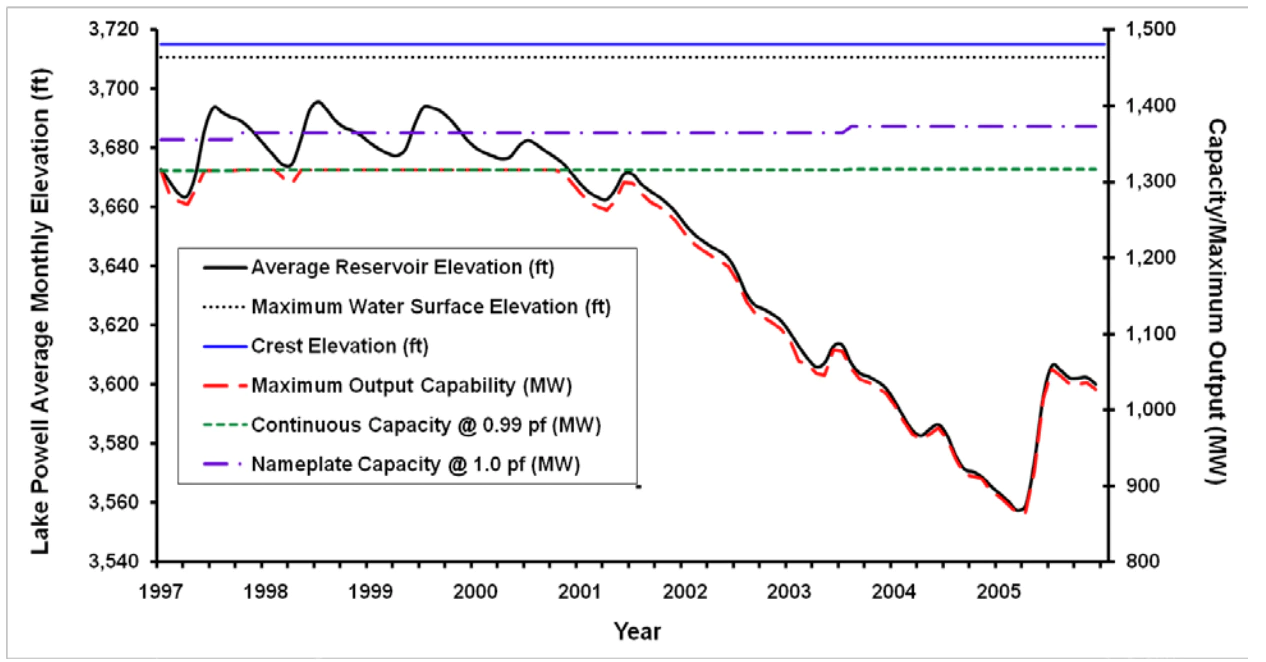
Output capacity of the dam’s turbines decreases in direct proportion to the reservoir’s surface elevation. As Lake Powell Shrinks, the dam generates less power. Source: Argonne National Laboratory.
Daniel Rothberg is a staff reporter covering water, climate change and public land.
Interior Secretary Deb Haaland, left, and Sen Joe Manchin participated in a roundtable event hosted by the White House Interagency Working Group on Coal and Power Plant Communities, on March 18, 2022. (Interior Department via Flickr/Public domain)
President Joe Biden’s climate agenda took a hit this month when the Interior Department said it would open 144,000 acres of federal land up for oil and gas development to comply with a court order to restart fossil fuel development.
The announcement marked yet another setback for a presidential climate plan that was once seen as historically ambitious.
Biden’s signature climate bill has gone nowhere in the U.S. Senate, he’s called for more domestic fossil fuel production to combat rising gas prices, and members of his own party doubt whether he can meet goals for a U.S. transition to electric vehicles.
GET THE MORNING HEADLINES DELIVERED TO YOUR INBOX
After noting climate as one of four crises facing the nation during his 2020 campaign, Biden gave it only a passing mention in his State of the Union address in March.
The White House defense on the oil and gas leases is that a court order forced adoption of a policy contrary to Biden’s climate objectives. Accompanying the move was a raise in the royalty rates for energy companies drilling on federal land, a reform long sought by environmental advocates.
But it still represented a departure from the president’s campaign rhetoric that promised no more drilling on federal lands, and it was met with derision by some environmental advocates.
Randi Spivak, the public lands director for the Center for Biological Diversity, called it “a reckless failure of climate leadership.”
Other advocacy groups were more understanding — the National Wildlife Federation, for example, stressed provisions of the restart that raised rates for fossil fuel development and limited the area that would be available.
As the nation having celebrated Earth Day on Friday, the administration has said it is still committed to climate action.
The evidence? Biden’s move to rejoin the Paris Climate Agreement, funding to target carbon reduction and electric vehicles in last year’s transportation infrastructure law, and a goal set to reduce carbon emissions by 50 to 52% below 2005 levels by 2030.
“The press and the pundits may want to declare President Biden’s climate agenda dead,” an administration official said at a press briefing Monday. “But this week, we will show how it is very much alive and well.”
Thursday, the Transportation Department announced a $6.4 billion program funded by the infrastructure law to help state transportation departments limit greenhouse gases from vehicles. Biden addressed climate issues in an Earth Day speech in Seattle Friday.
Here are three big reasons why the White House has struggled with its climate agenda:
Court decisions
During the presidential campaign, Biden pledged to end new fossil fuel development on federal lands. He followed through on that promise on his first day in office, issuing an executive order to pause new oil and gas leases as the administration reviewed the program and its impact on climate change.
A federal judge, though, U.S. District Judge Terry Doughty in Louisiana, found the executive order was illegal and ordered the administration to restart leasing.
In a tweet, Interior Secretary Deb Haaland said that the order forced the new oil and gas lease sales.
She noted the parcels available for lease were decreased 80% from what had been nominated for leases in 2021 and touted the raise in royalty rates from 12.5% to 18.75%.
Oil and gas infrastructure is seen on the Roan Plateau in far western Colorado. (Courtesy of EcoFlight)
White House press secretary Jen Psaki said the move “was the result of a court injunction that we continue to appeal. And it’s not in line with the president’s policy.”
House Natural Resources Chairman Raúl Grijalva, an Arizona Democrat and former chairman of the Congressional Progressive Caucus who has pushed the Biden administration for more ambitious climate action, accepted that the court order forced the administration’s hand and credited Haaland with the reforms.
“I’m glad we finally have an administration that recognizes that the status quo for our oil and gas leasing program is a rip-off for the American people,” Chair Grijalva said.
But some outside groups called it a violation of Biden’s campaign pledge.
Kyle Tisdel, director of energy and climate at the environmental legal group Western Environmental Law Center, said in an interview the administration had options, even after the “flawed” injunction from Doughty.
The court order only said the administration could not issue a blanket pause on new leases, he said. But the Bureau of Land Management could still decline to issues new leases on a case-by-case basis, he said.
Congress
Bipartisan members of the House and Senate passed a $1.2 trillion infrastructure bill that the administration helped steer and Biden signed last year.
A group of progressive lawmakers almost sank the measure over concerns it would exacerbate — not solve — the climate crisis. The administration and congressional leaders promised to pair the infrastructure bill with a sweeping $3.5 trillion bill that would include major climate provisions.
The House passed the larger bill, but the Senate never took it up. West Virginia Democrat Joe Manchin III came out against the legislation in December. With no Republican support, Manchin’s opposition doomed the bill in the evenly divided Senate.
“What the last year has shown us is that the Biden administration trying to calibrate action to the whims of certain senators or congresspeople or midterm elections has been sort of a fool’s errand,” Tisdel said.
Some members of Congress remain optimistic that a climate bill can be passed. Manchin has indicated an openness to supporting the clean energy tax credits in the Biden plan, but also has said that negotiations on the so-called Build Back Better plan must start from scratch.
U.S. Sen. Martin Heinrich, a New Mexico Democrat who earlier this year called for passing the climate provisions of the Biden spending plan, said in a Thursday statement he remained focused on expanding clean energy, funding conservation work and supporting fish and wildlife protections.
“All eyes are rightly on the Biden administration and on Congress to pass transformative climate investments,” Heinrich said. “We need to deliver.”
War and spiraling gas prices
Biden’s State of the Union address this year focused on the war in Ukraine, then just days old, and spiking prices for consumer goods — including energy.
His top priority, he said, was “getting prices under control.”
The drive to cut costs seemed to displace climate action, which he only mentioned twice, once in the context of lowering energy prices.
To address rising prices in the short term, Biden has also called on domestic producers to pump more oil and has released millions of barrels of oil from the Strategic Petroleum Reserve, a complex of underground storage caverns in Louisiana and Texas.
Biden, in Iowa, also waived a regulation banning sales of the ethanol blend E15 during the summer months. The Environmental Protection Agency normally doesn’t allow sales from June to mid-September due to concerns over air pollution.
Julie McNamara, a deputy policy director with the climate and energy program at the Union of Concerned Scientists, a climate advocacy group, said using rising energy prices to make the case should be an opportunity to hasten a transition away from fossil fuels to less volatile energy sources.
“We’re seeing a push from the fossil fuel industry and their supporters to increase our dependence on fossil fuels, to increase production and fighting back against clean energy,” she said.
“When every indicator says now is the time to be doubling down on our commitment to this clean energy transition.”
Colorado Newsline is part of States Newsroom, a network of news bureaus supported by grants and a coalition of donors as a 501c(3) public charity. Colorado Newsline maintains editorial independence. Contact Editor Quentin Young for questions: info@coloradonewsline.com. Follow Colorado Newsline on Facebook and Twitter.
Douglas County Commissioner Abe Laydon, right, with attorney Steve Leonhardt, who Douglas County has hired to help it work through RWR’s water exportation proposal. Photo credit: Alamosa Citizen
RIO Grande County Commissioner John Noffsker made Douglas County Commissioner Abe Laydon a counter-offer to the Renewable Water Resources exportation proposal: Douglas County gives the San Luis Valley its annual sales tax collections from Park Meadows Mall in exchange for some water.
Noffsker’s point? That the Valley has no more right to sales tax dollars collected by Douglas County than Douglas County has to water in the San Luis Valley aquifers.
Pleasantries were exchanged Saturday [April 23, 2022] between Laydon and a few mostly elected officials during a two-hour exchange at Nino’s Restaurant in Monte Vista. The conversation didn’t reveal anything new or anything Laydon and Douglas County haven’t heard over the past four months as Douglas County weighs whether to invest in the Renewable Water Resources water exportation plan.
“You’re the tip of the spear on this one,” Noffsker said in making Laydon aware that people watching Douglas County’s deliberations know Laydon holds the deciding vote on the three-member commission, with Commissioner Lora Thomas dead set against RWR and Commissioner George Teal in support.
“Once you start putting a straw in this body of water, there’s no end game,” Noffsker said.
“You’re basically saying to us, much as what happened to the Native Americans, that you have something we want and we can do more with it than you can, and that is wrong,” said Noffsker. “It’s morally wrong. When we have to sit here and defend how we use our water, we shouldn’t have to do that. This water belongs to the Valley. It should not be taken out of here to benefit somebody else.”
The meeting at Nino’s with Noffsker and other local elected officials was Laydon’s second of the day. Earlier Laydon and Special Counsel Steve Leonhardt met privately with farmers who Laydon said expressed a variety of concerns, from lack of knowing what’s going on in the subdistrict formations of the Rio Grande Water Conservation District to concerns about their small operations and whether small farms would survive the period of persistent drought and climate change.
With the local elected officials, which included Monte Vista Mayor Dale Becker and Alamosa Mayor Ty Coleman and Commissioner Lori Laske, Laydon raised the idea of a community fund that Renewable Water Resources has touted as part of its proposal. The Douglas County commissioner was told the community fund was a slap in the face to residents of the San Luis Valley.
“It’s not about money, it’s about keeping the (water) resource here,” said Alamosa City Councilman Mike Carson. Carson works at the Rio Grande Water Conservation District and is coordinating the Protect San Luis Valley campaign fighting the RWR exportation proposal.
Karla Shriver, president of the Rio Grande Water Conservation Subdistrict 2 board, said additional financial relief for Valley farmers is on the way through legislation currently moving through the state legislature. A bill sponsored by state Sen. Cleave Simpson would create a new compact compliance fund and would have around $30 million of American Rescue Plan Act money awarded to Colorado in it to help farmers in the San Luis Valley meet groundwater compliance targets set by the state. Read more about the legislation HERE.
Renewable Water Resources has voiced opposition to the legislation. It sees the bill as a government bailout for San Luis Valley farmers at a time when RWR is asking for money from Douglas County and dangling those tax dollars in front of Valley farmers to buy them out.
San Luis garden. Photo credit: The Alamosa Citizen
Noffsker said the RWR proposal is only about making a return on investment, while the Valley fights for its economic livelihood.
“I don’t mean any urban/rural fights,” said Noffsker. “But what’s happening is an urban area that apparently wants to grow more, wants to take from us to do it. If we do something like this, we are being dictated to by the Front Range on what our lives are going to be. That is not correct.”
Laydon, as he’s said in other meetings, told the group that Douglas County only wants to partner with communities that welcome Douglas County and that want to partner with it. He didn’t find that broad support on his weekend trip to the San Luis Valley, and he hasn’t heard any outpouring of support in the months he and his colleagues have been studying the Renewable Water Resources exportation plan.
Unless, of course, Douglas County wants to give up its retail sales tax revenues. Sacrificing a golf course or two might help as well.
Snow Water Equivalent in Blue from the NRCS. I believe the graph has some error the past few days. The peak was April 19, 2022 and the usual peak is April 22.
Click the link to read the article on the Summit Daily website (Eliza Noe). Here’s an excerpt:
As April comes to a close within the next week, snowpack for the Blue River remains below the median. Traditionally, snowpack begins to melt and trend downward in May. The 30-year median for the Blue River peaks on April 25 annually, with a steady downhill slope following for the rest of the summer. For weeks, snowpack measures for 2022 followed closely or mirrored the median but, toward the end of March into April, snowfall trailed behind, causing this year’s snowpack levels to trail, as well. Back in January, when local snowfall was high, 2022 even exceeded the median by several inches.
Precipitation in the Blue April 25, 2022 via the NRCS.
Overall, water year 2022 is in the 39th percentile for precipitation over the past three decades. According to data from the Natural Resources Conservation Service, 2022’s peak hit about a week early — on April 19 — stopping at a high of 15.7 inches of snowpack. Snow from this past weekend boosted the downward slope slightly from 14.1 to 14.5 inches, but levels are considerably lower than the median (86%). Still, 2022’s precipitation is ahead of last year, when snowpack levels for the Blue River never got above 13.5 inches.
Westwide SNOTEL basin-filled map April 24, 2022 via the NRCS.
Ranking and time evolution of summer (June–August) drought severity as indicated by negative 0–200 cm soil moisture anomalies. Maps show how gridded summer drought severity in each year from 2000–2021 ranked among all years 1901–2021, where low (brown) means low soil moisture and therefore high drought severity. Yellow boxes bound the southwestern North America (SWNA) study region. Time series shows standardized anomalies (σ) of the SWNA regionally averaged soil moisture record relative to a 1950–1999 baseline. Black time series shows annual values and the red time series shows the 22-year running mean, with values displayed on the final year of each 22-year window. Geographic boundaries in maps were accessed through Matlab 2020a.
Click the link to read the release from Ghent University on the Phys.org website:
Up to 30% of the rainfall deficit can be caused by “drought self-propagation,” the DRY–2–DRY European Research Council (ERC) project shows.
Unlike other weather extremes such as hurricanes or winter storms, droughts affect humans in most climatic zones around the world; from the arid steppes of the Sahel to the humid rainforests of Amazonia. Moreover, droughts are expected to intensify in many regions following global warming. The United Nations has recently described drought as “the next pandemic,” suggesting that the associated risks are currently overlooked. It is thus crucial to improve our understanding of drought, and particularly its causes, in order to be able to predict its future risk and enable adequate societal adaptation.
Rainfall deficits eventually manifest as dry soils. The land surface, though, also takes a very active role in the generation of rainfall, as it supplies moisture to the atmosphere through evaporation. What happens during a soil drought when far less water is evaporated than usual? It has been hypothesized that this can enable droughts to expand by themselves, as they provide less moisture for precipitation, not just locally, but also downwind. Until now, evidence of this drought self-propagation, fueled by the drying soils, had remained elusive. In a new study, published in Nature Geoscience, led by the Hydro-Climate Extremes Lab (H-CEL) at Ghent University (Belgium), this evidence is provided for the first time.
The authors analyzed the largest 40 droughts in recent history. For each event, the authors tracked the air over the drought regions as the drought area expanded. This allowed them to compute how much of the downwind rainfall deficits were caused by the upwind drying of the soils. Their conclusion was that in individual months, up to 30% of the rainfall deficit can be caused by this drought self-propagation. As Dominik Schumacher, first author of the study, states: “In essence, droughts behave similarly to wildfires: while fires propagate downwind by igniting more and more ‘fuel’ in their surroundings, droughts do so by reducing their own rainfall supply through the drying of the land surface.”
The authors find the strongest self-propagation in subtropical drylands, such as in Australia and Southern Africa—in these regions, the limiting effect of low soil moisture on evaporation is strongest. By definition, water is already scarce in drylands, yet these regions sustain a considerable fraction of the global human population and are also used extensively for farming.
Therefore, as drylands are projected to expand in light of climate change, the self-propagating character of droughts may lead to even larger and more rapidly evolving events in the future, and further exacerbate water scarcity as well as the attached socioeconomic and environmental consequences.
Dennis Gallagher officiating the Gulch’s wedding vow renewal celebration at the Baldpate Inn in Estes Park June 2003.
Click the link to read Westword’s obituary (Patricia Calhoun). Here’s an excerpt:
Denver is a duller town today. Dennis Gallagher passed away on Friday, April 22, after a short illness. He was 82. Word spread quickly through this city where he was born and raised, this city he’d devoted his life to serving. He did so everywhere from the Colorado Legislature to Denver City Council to the Denver Auditor’s Office, from classrooms to coffeehouses.
Gallagher grew up in north Denver and graduated from Regis University, where he taught off and on for forty years after getting a master’s degree from the Catholic University of America in 1967. Just three years later, he was elected to the legislature…he was still always out in public, hosting his St. Patrick’s Day celebrations, offering tours of cemeteries and other spots around town, and opining on just about everything, with that impish Irish wit and great, deep voice…He seemingly knew everything about Denver and everyone in it, past and present….
Dennis Gallagher’s world was this city. And for so many, he was this city.
Colorado River Basin Plumbing. Credit: Lester Doré/Mary Moran via Dustin Mulvaney and Twitter
Click the link to read the opinion piece on the AZCentral.com website (Joanna Allhands). Here’s an excerpt:
Opinion: It’s an imperfect plan that solves nothing. But it’s significant that all seven Colorado River states have agreed to temporarily boost Lake Powell.
The seven Colorado River basin states have a plan to temporarily stabilize Lake Powell. It contains some pain and not a lot of gain. Yet no one balked. And that’s a win. That should signal how dire the circumstances have become…
Interior proposed taking the unprecedented action of withholding 480,000 acre-feet (that’s more than 156 billion gallons) in Lake Powell that otherwise should have flowed to Lake Mead, among other measures. Two weeks later, the seven states responded with a singular voice: We get how dire this is, and we’re on board.
“We recognize the urgency created by current conditions in the Basin; in fact, hydrologic conditions in the Basin have continued to decline since your April 8, 2022, letter to the Governors’ representatives,” they wrote in an April 22 response. “It is our collective judgment that additional cooperative actions should be taken this spring to reduce the risk of Lake Powell declining below critical elevations.”
[…]
The idea, however ill-conceived, is not to use Mead’s actual elevation to determine which shortage tier we’d be in, but rather as if that 480,000 acre-feet were in Mead and not Powell. It’s not clear how the federal Bureau of Reclamation, which operates the reservoirs, would make that calculation, but the outcome could have real consequences…
The most recent forecast projects elevations as if that 480,000 acre-feet had flowed from Powell to Mead. It puts Mead a few inches above the trigger elevation of 1,045 feet in August, when the following year’s shortage determination is made. That would put us in a deeper Tier 2 shortage, regardless. But depending on which side of 1,045 feet we land, we could either fall in a Tier 2a or Tier 2b shortage – which for Arizona is the difference between making previously agreed cuts of 592,000 acre-feet or 640,000 acre-feet.
An irrigation ditch on Orchard Mesa in the Grand Valley, bringing water from the Colorado River to orchards and fields. The Grand Valley has been the center of discussions and a legislative effort around investment water speculation. CREDIT: BRENT GARDNER-SMITH/ASPEN JOURNALISM
Colorado lawmakers have suspended an attempt to prohibit outside investors from profiting off the state’s water.
On Thursday, the Senate Agriculture & Natural Resources Committee voted 5 to 2 to approve an amendment sending Senate Bill 29 back to the interim Water Resources Review Committee for more study and input from water users. However, at the end of Thursday’s hearing, Sen. Jerry Sonnenberg, acting as chair, decided to “lay over” the bill, meaning the committee would take it up at another time.
But with the 2022 legislative session ending on May 11, there is probably neither time nor the desire from lawmakers to push the bill through, meaning that, to all appearances, the legislation is dead. The Senate Agriculture & Natural Resources Committee would now have to take the measure back up and move it along to the full Senate and then to the House in order for it to go back to the interim committee.
Sonnenberg, R-Sterling, and Sen. Kerry Donovan, D-Eagle County, who initially proposed the back-to-interim-committee amendment and is a sponsor of the bill, were the two votes against sending the issue back to the interim committee. It’s unclear why Donovan, who did not return a call for clarification as of presstime, voted against her own amendment.
“We gave it a heck of a college try,” said Donovan, the twice-elected representative for Senate District 5, which includes Pitkin County, who will be stepping down at the end of the year due to term limits. “And I think we continued an important conversation. Water always takes a long time to figure out and I was certainly hopeful that by having a bill we would force conversation.”
Senate Bill 29, with Western Slope sponsors Donovan and Sen. Don Coram, R-Montrose, was an attempt to stop out-of-state investors in agricultural water from making a profit off a public resource that grows scarcer in a water-short future driven by climate change.
Many say investment water speculation is a threat, but few agree on what should be done about it. A legislative fix, despite several attempts at tweaks with amendments throughout the session, failed to gain support from the constituency the bill aimed to protect: agricultural water users. Although some agricultural water rights holders recognize there could be negative impacts to their communities if water is sold to investors, they don’t want the state making the process of selling their ranch harder, placing restrictions on who they can sell to or limiting their ability to make a profit.
The original bill would have given the state engineer at the Department of Water Resources the ability to investigate complaints of investment water speculation and fine a purchaser of water rights up to $10,000 if they determine speculation is occurring.
That version failed to gain traction, as did a handful of proposed “strike-below” or “strike-through” amendments, including one put forth by the Colorado River Water Conservation District, which would have addressed speculation using the abandonment principle by saying that if someone was getting paid to not use their water, they could be punished by losing their water right.
Donovan then floated the most recent amendment that would have sent the issue back to the interim Water Resources Committee for further study and input from water users, a move Coram said was kicking the can down the road.
Lawmakers scolded some in the water community for what they said was a lack of cooperation and communication around developing legislation aimed at preventing speculation.
“We have an ineffective water group that won’t have a conversation with lawmakers anymore,” Sonnenberg said. “When we have a bill they just take a position and quit working with people.”
WAM bought this 57-acre parcel as part of a $6 million deal in January 2020, leading some to suspect the company was engaging in investment water speculation. WAM’s activity in the Grand Valley helped prompt state legislators to propose a bill aimed at curbing speculation. CREDIT: BETHANY BLITZ/ASPEN JOURNALISM
Bill opposition
At Thursday’s hearing, several people testified in opposition to the bill. Colorado Water Congress, Colorado Farm Bureau, Rocky Mountain Farmers Union, as well as three Grand Valley water providers, among others, were opposed to the bill.
Former state representative from Gunnison County Kathleen Curry works as a lobbyist on behalf of the Orchard Mesa Irrigation District, Grand Valley Water Users Association and the Ute Water Conservancy District, organizations that provide agricultural and domestic water to the Grand Valley. She said her clients would support taking more time to consult with experts and stakeholders.
“My folks have two major concerns regarding the legislation as it was introduced and as it’s been contemplated so far,” she said. “One has to do with the additional time needed to obtain feedback from the affected parties and water rights owners and secondly, they are still a bit unclear about the need for legislation, and the scope of potential impacts to water rights owners remains a concern.”
Bicycling the Colorado National Monument, Grand Valley in the distance via Colorado.com
The Grand Valley has been the center of investment water speculation concerns, where New York City-based private-equity firm Water Asset Management has been acquiring irrigated farmland. WAM is now the largest landowner in the Grand Valley Water Users Association. But as long as WAM keeps putting the water to beneficial use and keeps the land in agricultural production — which it appears to be doing — it doesn’t count as speculation.
Still, the threat from out-of-state, urban interests loomed large at Thursday’s hearing.
“We were hearing across our districts and state about a new type of player in the water world,” Donovan said. “And that player was custom suits and shiny shoes that call big cities home. … There was concern from many in the water world that probably an investment firm was not going to be the best partner moving forward.”
In an attempt to address the issue in 2020, legislators convened a workgroup, made up of water managers and policy experts across sectors to explore ways to strengthen the state’s anti-speculation laws. Saddled with the incredibly complex task of figuring out how to protect Colorado’s water from profit-seeking investors without infringing on private property rights, an August 2021 report from the workgroup did not give recommendations to lawmakers because they could not come to a consensus about which concepts to implement. The group’s report did, however, lay out potential avenues new regulations to prevent investment water speculation could take.
For Loma rancher, workgroup member and President of GVWUA Joe Bernal, the lack of consensus meant that lawmakers should not move forward with any legislation.
“Our group found it very important that more information be gathered from landowners and stakeholders,” he told the committee Thursday. “I find it very concerning that bill sponsors moved forward with the crafting of an anti-speculation bill when there seems to be very little support from the people and the citizens it seems the sponsors are trying to protect.”
An irrigated field in the Grand Valley, near Grand Junction made green by water diverted from the Colorado River. Grand Valley water user groups were opposed to Senate bill 29, which was aimed at preventing investment water speculation. CREDIT: BRENT GARDNER-SMITH/ASPEN JOURNALISM
Threats to agriculture
The concern at the heart of the speculation issue is not that investors could profit off of Colorado’s water. Underneath, there is a broader fear about the loss of agricultural land and with it, a way of life and a part of Colorado’s history, culture and identity. The work group identified the large-scale, permanent dry-up of agricultural lands as the No. 1 risk from speculators.
For Bernal, the bigger threat to Colorado agriculture comes from developers who would subdivide the land for houses and ranchettes and take it out of agricultural production. The acres that were sold to WAM, which are still being farmed, could have been sold instead to developers, an outcome he doesn’t want to see.
“I think it could be studied further, but at this point we don’t have a problem yet,” Bernal said. “I’m not saying I’m glad WAM is here, but it seems to be the lesser of two evils. Given the choice of having the land developed, it’s a better option.”
Aspen Journalism covers rivers and water in collaboration with The Aspen Times. This story ran in the April 23 edition of The Aspen Times.
At the April 14 Pagosa Area Water and Sanitation District (PAWSD) board of directors meeting, District Manager Justin Ramsey updated the board on the situation concerning the Pagosa Springs Sanitation General Improvement District (PSSGID).
Ramsey highlighted that he had met with the Town of Pagosa Springs and PSSGID and that they had together developed an emergency plan if the pumps moving sewage from downtown to the PAWSD Vista Treatment Plant fail. Ramsey also explained that the town is “really frustrated” by the current pumping arrangement and is considering developing a new wastewater treatment facility near the proposed Yamaguchi South Park, which he estimated might cost the town $10 million to $20 million. Meanwhile, Ramsey added, PAWSD is planning state-mandated improvements to the Vista Wastewater Treatment Plant at the cost of $20 million to $30 million.
Ramsey then suggested the possibility of the town and PAWSD cooperating on developing a plant by Yamaguchi South and reversing the current pipeline from that area to Vista to transport sewage downhill from Vista to the new plant. However, he added that, even if this plan is approved, it would likely be at least eight years before the project would be completed.
The back of Glen Canyon Dam circa 1964, not long after the reservoir had begun filling up. Here the water level is above dead pool, meaning water can be released via the river outlets, but it is below minimum power pool, so water cannot yet enter the penstocks to generate electricity. Bureau of Reclamation photo.
Late last summer, on a work trip through the Southwest, I sought refuge from triple-digit temperatures in an air-conditioned Page, Arizona, motel room, offered at a discount because, I presume, the hotel and motel companies built way too many rooms for a declining number of visitors.
As I’m prone to do when in a hotel room, I flipped on the television. A bona fide, decades-old disaster movie, in the vein of Airport or Avalanche, played on the vast, flat screen. A dam—and everyone downstream—were in peril, threatened by hubris, Nature, faulty weather forecasting, and, most ominously, cavitation. The heroes were played not by Burt Lancaster or Jean Seberg, but by themselves—mustachioed, wire-rim-glasses-wearing engineers. Real ones.
It wasn’t a feature flick after all, but The Challenge at Glen Canyon, a Bureau of Reclamation-produced documentary about a real disaster, narrowly averted, that played out in the summer of 1983, when a snow-swollen Lake Powell jeopardized one of the nation’s largest dams.
The narrative was certainly enthralling. But maybe more stunning were the images of of a Lake Powell full to the brim, water nearly lapping at the crest of the dam. It provided an eerie contrast to the scene outside my hotel room window: the hulking figure of Glen Canyon Dam and, behind it, the pale bathtub ring on the sandstone indicating just how far the water levels had dropped since the documentary was made.
Another disaster is underway at Glen Canyon Dam, a slow-motion one, caused by too little water rather than too much. Yet in a bizarre twist, some of the potential effects may mirror those in 1983. Now Bureau of Reclamation engineers once again are scrambling to keep reservoir levels from falling further in hopes of preserving the dam’s hydropower production capacity—and maybe even the dam, itself.
I watched the documentary to its end, switched off the television, and gazed back out the window—the surreal greenish-brown grass on the golf course, the transmission infrastructure sprouting from red rock, the still water of the reservoir. I thought I could see Lake Powell’s murky green water evaporating into the smoky blue sky.
I’m no fan of dams. They turn living rivers into stagnant puddles, kill fish, drown canyons and communities. Glen Canyon may be the most heartbreaking of all. So much was lost when the tempestuous waters of the Colorado backed up behind it into countless canyons and coves, inundating a million marvels, cultural sites, monkey-flower strewn alcoves.
And yet, from a more pragmatic viewpoint, I understand Lake Powell’s value, not just as a big water bank, but also as an indispensable tool for grid operators. Hydropower was chosen to run the first electricity grids for a reason: It’s reliable and flexible and you don’t have to mine or burn anything.
Glen Canyon Dam’s eight giant turbines have a generating capacity of about 1,300 megawatts when the reservoir is full, on par with a large coal-burning power plant, which act as a “baseload” power source, like a nuclear or coal power plant, cranking out a steady stream of juice delivered to some 3.2 million customers, including utilities, tribal nations, and federal agencies. Even more critical—and lucrative—the dam’s power output is highly adjustable, making it ideal for “following the load,” or ramping up or down quickly to meet a spike in energy demand or a void in generation if another power plant goes down (1). Glen Canyon Dam electricity sales generate as much as $200 million annually—the only direct form of revenue from the dam or reservoir, since the water is not sold—a portion of which is used to fund endangered species recovery, salinity control and water studies on the Colorado River.
With that in mind, the 710-foot tall dam was designed so that all of the water routinely flowing downstream from Lake Powell goes through eight penstocks, or big pipes leading to the turbines. That way all of the released water generates electricity, and therefore revenue. The dam is also equipped with “river outlets,” positioned below the penstock openings, to allow water to be routed around the turbines if needed or for larger releases than the penstocks, alone, can handle. There are also two spillways, giant tunnels carved through the sandstone cliffs on either side of the dam, for rare instances when the water level exceeds “full pool” and needs to be spilled. But neither the outlets nor the spillways were designed for long-term, continuous use. In fact, wrote W.L. Busho, a longtime PR person for the Bureau of Reclamation, “a well-managed reservoir should almost never spill.”
Construction on the dam began in 1956 and it started backing up water in 1963. It took 17 years to fill Lake Powell, finally reaching its storage capacity in 1980. From then on, dam managers would release just enough water during the winter to meet downstream obligations and to leave enough room in the reservoir for the projected spring runoff. But during the winter of 1982-83, they misread the signs.
For most of the winter, snowfall throughout the 108,000 square mile watershed that feeds Lake Powell was just a little above average. Then an especially robust El Niño kicked in, and in April and May snow piled up in the mountains to depths not seen since the early 1950s. The Basin-wide snowpack finally peaked in late May, several weeks later than normal. Then temperatures shot up suddenly, accompanied by heavy, snow-melting June rain that put nearly every stream and river in the region well above flood stage.
Caught off guard by the deluge, dam operators had not left enough room in the reservoir to contain the sudden surge of Colorado River inflows, which reached 120,000 cubic feet per second—about 10 times the volume of an average spring runoff. Dam operators cranked open the penstocks, sending about 29,000 cfs through the turbines, as well as the river outlets for an additional 15,000 cfs. It wasn’t nearly enough. So, with water literally lapping at the crest of the dam, operators opened the left spillway for the first time ever, sending another 32,000 cfs through the concrete-lined tunnel, which then shot out of the cliff hundreds of feet below to spectacular effect (and giving river runners a wild ride). For a day or two, all seemed fine. Then, things got scary, as described by T.J. Wolf in a harrowing feature in High Country News:
“If you were on the bridge below the canyon that spans the dam that June morning … you would have seen a sight terrifying enough to put the fear of God into anyone, but especially into an engineer. You would have seen the steady sweep of the spillway mouths suddenly waver, choke, cough and then vomit forth half-digested gobbets of steel-reinforced concrete (bad, very bad), spew out blood-red water (My God, it’s into bedrock), and finally disgorge great red chunks of sandstone into the frothy chaos below the dam. You would have seen the Colorado River going home, carving rock, moving deeper, as it has always done.”
The problem was caused by cavitation: collapsing vapor bubbles in the water sent shockwaves through the tunnel’s innards, tearing through the concrete and then the sandstone, potentially threatening the dam, itself. Engineers had to shut off the flow into the spillways in order to assess and repair the damage inside. That was easier said than done: The lake was so full the water was spilling over the top of the spillway gates. Engineers—the stars of the 1983 disaster documentary—scrambled to find a solution.
Peak streamflow levels at Lee’s Ferry, just below Glen Canyon Dam. Before the dam, 100,000 cubic feet per second was common. Source: USGS.
When officials from the seven Colorado River states got together in 1922 to parcel out the river’s water, they assumed that some 15 million acre feet of water passed by the Lee’s Ferry dividing point each year, on average, based on a couple decades of streamflow measurements. When Mexico joined the party they simply added another 1.5 million acre feet. This turned out to be a significant overestimate: Tree ring studies later found that the historic average was closer to 14 million acre feet or even lower, which amounts to hundreds of billions of gallons less than was parceled out to the states.
For decades, this wasn’t cause for too much alarm. After all, that’s what dams are for, to store up water during the soggy years to carry users through the dry times. While this became more challenging as the Southwest’s population and water consumption boomed2, it generally worked. The bountiful 1980s filled Lake Powell to the brim. An ensuing string of dry years drew the surface level down nearly 100 feet, but it quickly rebounded when the snows returned in the mid-1990s. Glen Canyon Dam was doing its job, storing water while also churning out gobs of power to keep a burgeoning number of air-conditioners humming.
But over the last two decades, the dam’s storage and power-generation capacities have been compromised as climate change-induced drought shrinks the reservoir behind it. Lake Powell’s surface level has trended downward since 2001, with a brief respite in 2011. Last July it dropped below 3,555 feet—or 153 feet below the 1983 peak—the lowest since it was filling up in the 1960s and ‘70s. Since then it has continued to plummet and in mid-April appeared to level out at 3,522 feet.
Power output at Glen Canyon Dam, 1980-2005. Note how the abundant water years of 1983-1986 were also big power years. Source: Argonne National Laboratory
As water levels drop the hydropower “head” does, too, thereby decreasing the potential energy of the falling water, which in turn lowers the generating capacity of the turbines. In other words, as Lake Powell shrinks, more water must be released to generate the same amount of power, which further lowers the lake level, and so on. In the 1990s, the dam produced as much as 7,000 gigawatt hours per year, enough to power nearly 600,000 homes. Last year, it was down to just 3,000 gigawatt hours. This phenomenon has forced Western Area Power Administration, the federal governmental organization that markets Glen Canyon Dam’s power at lower-than-market rates, to purchase more expensive power from the open market, driving up its customers’ costs.
Output capacity of the dam’s turbines decreases in direct proportion to the reservoir’s surface elevation. As Lake Powell Shrinks, the dam generates less power. Source: Argonne National Laboratory.
But this chronic decline in generating capacity is about to become more acute—and potential fodder for a new disaster documentary. If the reservoir’s level drops another 33 feet, to the 3,490-foot minimum power pool level, air could get entrained in the turbine-feeding penstocks, wreaking all kinds of havoc. At that point, or perhaps even sooner, operators have no choice but to stop sending water through the turbines, killing power generation and depriving the grid of enough electricity annually to power about a quarter of a million Arizona homes. It would also drain between $100 million and $200 million annually from dam electricity sales
That would force WAPA to purchase more expensive power, including electricity generated from natural gas or even coal, to supply its millions of customers. The average utility customer might not even notice the dollar or two this adds to their monthly bill, but it could amount to a substantial price hike for the tribal nations that rely on WAPA for most or all of their power. The Navajo Tribal Utility Authority’s yearly power bill could jump by as much as $1.3 million, according to a 2016 consultant’s study, and nine other tribes would also see significant cost increases.
Equally worrisome is how grid operators will fill the generation void left when the dam goes offline. New wind and solar power, paired with batteries or other energy storage, can replace some or all of the baseload power. But any extra generation capacity is going to be in high demand as big coal and nuclear plants retire in the next few years. Meanwhile, solar and wind can’t follow loads like a hydroelectric dam, so utilities are likely to turn to greenhouse gas-emitting natural gas “peaker” plants instead.
Then there’s the impact to the dam itself. Once the turbines are shut down, the only way water can be released is via the concrete river outlets, also known as “jet tubes” because they spray water into the riverbed like giant firehoses. These tunnels have only been used for short stints during the 1983 and 1984 high water years and for experimental high-flow releases intended to mimic natural river conditions and redistribute sediment in the Grand Canyon. No one knows how long they can be run at full throttle before cavitation begins.
“Glen Canyon Dam was not envisioned to operate solely through the outworks for an extended period of time,” wrote Tanya Trujillo, the Interior Department’s assistant secretary for water and science, in a letter to Colorado River state governors earlier this month, “and operating at this low lake level increases risks to water delivery and potential adverse impacts to downstream resources and infrastructure.” If levels drop much lower, the City of Page and the LeChee Chapter of the Navajo Nation would lose their Lake Powell drinking water supply.
“Glen Canyon Dam facilities face unprecedented operational reliability challenges,” Trujillo added. In other words, maybe it will all be fine. Or, maybe, it will be like 1983 all over again.
Cavitation at the Glen Canyon Dam, the cause of the emergency in 1983 via Flow Science.
The Challenge at Glen Canyon ends on a triumphant note, major-chord music blaring in the background. The engineers jerry rigged a fix for the spillways, extending the gates’ heights with plywood, then steel, plates. They held until the raging Colorado River calmed down and the crisis was averted. Inside the tunnel workers found huge fissures in the concrete and rock and set about building an aeration slot along the tunnel floor to prevent cavitation in the future.
The multi-million-dollar upgrades3 completed after the near-disaster, the narrator says, marked, “a victory for the human spirit, for the leaders who cut through the red tape … for the men and women who worked long hours and did the job. The American people who own this dam and Lake Powell can be confident that when the flood waters run down the Colorado, Glen Canyon Dam will be ready.”
The engineers are scrambling again, this time hoping to delay the dip into minimum power pool territory. Last fall the Bureau of Reclamation upped releases from upstream dams to try to keep Powell’s levels from dropping into the 35-foot buffer zone, draining Western Colorado’s Blue Mesa Reservoir to all-time lows in the process. Although the move failed to stop Lake Powell’s decline, it did slow it down, giving water managers more time to consider their options. This winter and spring they released less water than normal from Glen Canyon Dam, hoping to make up for it during spring runoff.
Nevertheless, outflows consistently have exceeded inflows, evaporation continues, snowpack is below median levels in the Upper Colorado watershed, and lake levels have dropped a total of 41 feet over the last year. Now water officials are exploring ways to modify the dam to enable it to continue producing power at lower levels—possibly by adding turbines to the river outlets—a sort of modern version of the plywood spillway gates of yore. And in the aforementioned letter, Trujillo floated the possibility of cutting overall releases this year to just 7 million acre feet, about 1 million less than normal, and a half-million less than planned this year, which would then cause Lake Mead’s levels to drop even further and could spur further cutbacks for downstream water users.
Unlike the floods of 1983 and 1984, the real disaster looming over the region today—human caused climate change and long-term aridification—is not going to subside in a month or year or even a decade. The question now is not whether Glen Canyon Dam will be prepared, it will not. Lake Powell will reach the dreaded dead pool, when the lake falls so low water cannot be released except by pumping it out or re-opening the tunnels excavated to divert the river during dam construction. Maybe it will happen in five years, maybe 20, but it’s coming. The real question is whether we, the residents of the West who rely on the Colorado River—and Glen Canyon Dam—for so much, will be ready for the inevitable.
(1) During the 1980s dam operators had ample leeway to “follow the load” by modulating the flow of water through the turbines. This occasionally caused huge fluctuations in the flow of water through the Grand Canyon. On one July day in 1989, for example, about 3,471 cubic feet of water per second was running through the dam at 5 a.m. By 3 p.m., it had jumped to 29,000 cfs—the maximum flow through the turbines—to provide juice to the Southwest’s power grid to keep all those air conditioners running. If you’re a river runner, you can probably imagine how disruptive—and even terrifying—this might have been to boaters in the Grand Canyon. In the early ‘80s dam operators wanted to maximize the potential for following the load by also installing turbines in the river outlets so they could generate even more power by releasing more water. The proposal was shot down and set off a string of events that ultimately led to significant changes in the way the dam is operated, including minimum and maximum release rates and maximum fluctuation rates, thereby limiting its capacity as a “peaker” plant.
(2) Water demand on the Colorado has increased substantially since the Colorado River Compact was signed, obviously, and continued to climb up until the late 1990s, when it plateaued and even dropped with the onset of the current megadrought in the early 2000s.
Consumptive water uses and losses on the Upper Colorado River Basin. Source: USBR
(3) The estimated cost to repair both spillways was about $30 million, according to one estimate, but this was offset by the $34 million in electricity sales revenue generated by running the turbines at full throttle for a good part of the summer.
Click the link to read the newsletter on the Middle Colorado Watershed Council website (Click through and volunteer to do some sampling or whatever.). Here’s an excerpt.:
The Colorado Water Conservation Board (CWCB) has granted three more years of funds to the Middle Colorado Watershed Council (MCWC) to continue the United States Geological Survey (USGS) water quality and rain gauge monitoring set up in 2021, adding new mid-stream water quality monitoring stations between South Canyon and Cameo, soil moisture monitoring, and a dashboard notification system for downstream municipalities.
The Colorado River District has agreed to serve as fiscal agent for the USGS in a three-year cooperative agreement with MCWC. The $583,396 CWCB grant will be matched with in-kind labor and cash from the USGS, Garfield County, the Glenwood Canyon Restoration Alliance, and coordinated project funding from the Colorado Department of Public Health and Education (CDPHE) for a total project cost of $1.3 million over the next three years.
Funding secured from CDPHE, $206,600, will be used to purchase the additional equipment needed for the new mid-stream water quality station, soil moisture monitors, and the user-friendly dashboard for downstream users to monitor changes in water quality and rainfall information. The CDPHE funding will also support pre-fire mitigation planning and allow the Silt Water Conservancy District to complete repair work from damage due to the continual impact of high amounts of sediment in the Colorado River in 2021.
Since early 2021, the Middle Colorado Watershed Council has coordinated post Grizzly Creek Fire water quality and rain gauge monitoring to set up a regional notification system and lessen the impact on downstream water users. MCWC received the first year of funding from CWCB, CDPHE and the Colorado River District’s Community Partnership Funds.
Using services from the USGS Colorado Water Science Center, the USGS Next Generation Water Observing System (NGWOS), and SGM, an engineering firm acting as MCWC’s technical advisor, water quality and precipitation information networks were set up in canyon drainages and on the Middle Colorado river corridor. Seven rain gauges were deployed throughout the Grizzly Creek burn area and a 6-parameter data sonde water quality monitoring station was set up at No Name.
During the summer of 2021, summer monsoons caused flooding, debris flows and highway infrastructure damage in Glenwood Canyon as a result of the 2020 Grizzly Creek fire burn scar and a 500-year-rain event. MCWC and other stakeholders expect continued problems with flooding and debris flows from these canyon drainages over the next few years and sought the additional funding to continue and expand monitoring in 2022 through 2024.
It’s a commonly known spot off County Road 17 between Del Norte and South Fork. Driving in you might see a blue heron standing off in the marsh and river rafters looking to get onto the Rio Grande at the very spot Colorado has been measuring the river since the summer of 1889 – June 1, 1889, to be precise.
This time of year, with any ice on the river gone and the weather warming, Jessie Jaminet comes every two weeks to the stream gaging station operated by Colorado Division of Water Resources to make sure everything is functioning for measurements that are closely watched by water managers up and down the Rio Grande. He was there this past week to get an early spring reading and when prompted for a prediction on this year’s flows said, “I think we’re probably going to be slightly below average from what I’ve seen.”
1934 and 1960. Credit: Alamosa Citizen
Average over the past decade has been 491,000 acre-feet of water; historically going back to 1889 the Rio Grande has an average measurement of 639,000 acre-feet, according to figures maintained by the state.
Jaminet, lead hydrographer for state water resources division 3, cautions that the river “changes daily right now.”
“Any storm that hits right now is a huge benefit for the whole system. People watch the snowpack numbers, but it really depends on what happens this time of year. Wet spring storms really benefit the system,” he said.
The Rio Grande gaging station near Del Norte is the highest profile gage station in the Upper Rio Grande Basin. That’s because it’s the gaging station the state uses to help determine how much water from the Rio Grande is available and will be delivered downstream into New Mexico and Texas as part of the three-state Rio Grande Compact.
Besides measuring lower-average acre-feet the past decade, another phenomenon has been occurring: an earlier peak to the river flow and then a quick dropoff, which means less water and shorter irrigation seasons downstream for New Mexico and Texas.
The stream gaging station operated by Colorado Division of Water Resources highway 17 between Del Norte and South Fork. Photo credit: Alamosa Citizen
“Historically the river would peak and we would maintain those flows for a while before we would fall into base flow conditions,” Jaminet said. Peak flow used to hit mid- to late-June and the Rio Grande would maintain itself through the summer. Now the state is seeing peak Rio Grande flows as early as late May and then drastic drop offs to the height of the river. It’s attributable to the aridification of the Valley floor from persistent drought and climate change.
Colorado’s obligations under the Rio Grande Compact is another aspect to the management of the upper basin of the river that water managers, irrigators, and outdoor recreationalists have to factor in when planning their own water usage.
“This is what we base pretty much all of our numbers on, this upper index here. Anything that passes this gage here we have to deliver a percentage of it downstream. This is why this is an important gage here,” said Jaminet.
He’s been working the measurements the past 15 years as part of his job with Colorado Division of Water Resources to operate and maintain the gaging stations along the Upper Rio Grande Basin. It’s not what he planned on doing for a career when he graduated from Mountain Valley High School in Saguache in 2001 and then the University of Wyoming, where he majored in rangeland geology and watershed management. But he’s learned and come to understand the importance of taking the river’s measurement, and the fact he grew up in the San Luis Valley makes him appreciate the work he does even more.
“This is a continuous record that we produce here,” he said of the Del Norte gaging station, pointing to the readings from 1890 through 2021. One of the most eye-popping historical figures is Oct. 5, 1911, when the Rio Grande was flowing at 18,000 cubic feet per second. The day Jaminet was at the gage station the river was moving at 519 cfs.
Most of the big diversions to the Rio Grande happen a bit farther downstream in Rio Grande and Alamosa counties, making the gaging station near Del Norte a natural location to determine the depth and velocity of the river.
A float sitting in a stilling well reads the height of the river. Photo credit: Alamosa Citizen
In the 1890s and early decades of the 1900s the state division of water resources would take a measurement of the Rio Grande twice a day and then daily as it kept improving the system. It eventually installed a continuous reader in 1983, and then in the summer of 1984 a satellite monitoring system was installed.
Now the gaging station takes a reading every 15 minutes and logs and transmits the data every hour to the Colorado Division of Water Resources website, where it’s tracked and followed by the three states party of the Rio Grande Compact. Fishermen and rafters will also monitor the web site to help them determine the best times to fish and float the river.
One of Jaminet’s responsibilities is to make sure the gaging station is calibrated and reading accurately. A float sitting in a stilling well reads the height of the river and then a rating table unique to the gaging station is applied to give an accurate measurement. In the winter months, with ice on the river, the measurements are more estimates.
Coming off a dry 2021, in January the Rio Grande was at its lowest point to start a year since Colorado began taking measurements 132 years ago. A cooler March and April have helped, but without significant summer rain, the Rio Grande will run dry again early in the summer irrigation season.
“If you go into the fall really dry, even if you get these big spring storms it seems like it just goes into the ground,” Jaminet said. “A lot of it is not making it to the river anymore.”
The measurements at the Rio Grande gaging station near Del Norte tell the story.
Jaminet makes regular checks on calibration. Photo credit: Alamosa Citizen
Mammatus clouds, associated with strong convection, grace a sunset over Fort Collins, Colorado, home of the NOAA Cooperative Institute for Research in the Atmosphere at Colorado State University. Photo credit: Steve Miller/CIRA
Water Planet
The abundance of water on Earth has shaped nearly every aspect of our lives, even if we are not directly aware of it. Using data sets from a variety of sources, including NOAA and NASA, water is shown to be the primary driver of Earth’s dynamic systems. It is the source of all life on the planet, which is astounding, considering just how rare and precious Earth’s fresh water resources are
Four times this spring, local resident and Desert Research Institute scientist Rosemary Carroll will aid Rocky Mountain Biological Laboratory (RMBL) field scientists, Alex Newman and Curtis Beutler. They will perform ground surveys as airplanes use high resolution lasers to measure the depth of the snowpack and snowpack reflectivity, or albedo. They will dig snow pits for detailed measurements of snow depth, hardness and density. In addition, they will look at snow grain size and shape and note any dust layers. The data helps determine the accuracy of the measurements conducted by the air.
“These airborne data collection efforts provide a map of our snowpack at high-spatial resolution from the mountain tops to the valley bottom. When ASO (Airborne Snow Observatory) is combined with ground surveys and snow observations over time at our snow telemetry (SNOTEL) network, we can better track our snowpack and manage our water resources,” Carroll explained. “As climate changes, stream water forecasting models built on historical precedence, are not able to adequately predict stream runoff. The ASO methodology has been shown effective in California for improving stream water forecasting…The state of Colorado has recently allocated nearly $1.9 million to track snow using ASO.
One of the two Twin Otter aircraft used by the Airborne Snow Observatory mission to study snowpack in the Western U.S. Credit: NASA
Carroll explained that ASO flies a fixed-wing aircraft across the basin using LiDAR (Light Detection and Ranging) with no snow, and then again with snow. The difference between the two data sets produces a snapshot in time of snow depth every three meters. ASO also uses a spectrometer to measure snow reflectivity. New snowfall has a very high reflectivity, while older snow or snow with dust has a lower reflectivity. Less reflective snowpack will melt more quickly than high reflective snowpack. The resulting ASO data helps to generate precise readings on the amount of water in the snow and guide estimates on where and when this snow may melt soonest. ASO not only quantifies total snow volume but also indicates where snow has moved across the landscape through things like avalanches and wind. ASO-informed stream water forecasts have been shown to have accuracy rates of close to 98% or almost double traditional forecasts…
Carroll is also managing a local stream discharge network so that there is high spatial and temporal data of streamflow across the smaller-order streams in the East River. She has stream gauges on Quigley, Rustlers, Rock and Copper Creek, to name a few. She currently manages 13 stream gauges. By measuring streamflow across the upper East River and in combination with the stream gauges maintained by the U.S. Geological Survey (USGS), she can monitor sub-watershed response to different snow conditions…
Carroll emphasized that mountain snowpack is a critical water resource globally and is also extremely sensitive to climate change. “The East River is emblematic of these mountain systems, and it has become the largest field observatory for integrated mountain hydroclimate and biogeochemical response,” she said. “Work between entities like the Department of Energy, NASA, NOAA, the USGS and others, and with help from RMBL, the research in the East River is critical to understanding how mountain systems store and release water and solutes. It is extremely exciting!”
Colorado officials are failing to respond to climate change with the urgency the crisis demands. The least they can do is let everyday Coloradans help.
The state already expects residents to do their part. Gov. Jared Polis prefers to nudge individuals to make lifestyle changes such as upgrading to an electric vehicle rather than require that a corporation inconvenience itself with new climate-saving measures.
But the state should give individuals the most muscular climate-action tool there is — the power to sue.
GET THE MORNING HEADLINES DELIVERED TO YOUR INBOX
With such authority at citizens’ disposal, Colorado would have all the personnel it could need to help the state enforce its environmental standards.
Texas lawmakers when they adopted the odious anti-abortion Senate Bill 8 last year understood the potential of citizen suits, in which private citizens are empowered to enforce laws through the courts. Texas Republicans adopted an extreme form of citizen-suit authority as an underhanded device to shield the law from legal challenge, but citizen suits themselves are nothing new.
A key component of the nation’s primary environmental laws — such as the Clean Air Act and the Clean Water Act — is that they allow “any person” to sue to ensure compliance with the laws and to force federal environmental agencies to do their job.
“The citizen suits provision reflected a deliberate choice by Congress to widen citizen access to the courts, as a supplemental and effective assurance” that federal environmental laws would be implemented and enforced, said the D.C. Circuit U.S. Court of Appeals in 1974.
Some research suggests that most federal citizen suits are filed under the Clean Air Act, which sets national emissions standards for a wide range of air pollutants and regulates the toxic substances electric utilities and other large sources can release into the air. It was under the Clean Air Act that in 2017 that environmental advocacy group WildEarth Guardians brought a successful citizen suit against Colorado Springs Utilities, which resulted in air quality improvements at the coal-fired Martin Drake power plant.
Many states grant citizen-suit authority for enforcement of state environmental standards, which can be more protective than federal standards. Colorado is not one of them. But it should be.
A report from 2004 put at 16 the number of states that had granted citizens “general authority to enforce state environmental statutes,” the exemplar being Michigan. Colorado law allows for citizen suits related to a narrow form of oil and gas regulation, notes Jeremy Nichols, climate and energy program director for WildEarth Guardians. But to his knowledge the provision has never been invoked, he said. And Newsline confirmed this week that citizen-suit authority remains absent from the Colorado parallels to the Clean Air Act and the Clean Water Act.
“The state-level versions of those acts, including the Solid Waste Act, Hazardous Waste, or Air Pollution Prevention and Control Act, do not have citizen suit provisions,” wrote a spokesperson for the Colorado Department of Law in an email.
The Legislature should update these sections of state environmental law by inserting citizen-suit authority. A 2022 bill, in fact, that never got beyond draft form would have granted citizen-suit authority in Colorado for “certain clean air regulations,” according to a version shared with Newsline. The draft indicated that Boulder Democratic Rep. Edie Hooton had contemplated sponsoring it. Hooton did not respond to a message seeking comment.
Why not let citizens lend a hand? Give them access to the courts and watch enforcement of the state’s environmental standards achieve a new urgency.
The stakes of the climate change crisis warrant an all-hands-on-deck approach to enforcement of environmental regulations. As a practical matter, Colorado could use all the help it can get. The state’s clean-air regulatory bodies have long faced complaints they lack the resources to properly keep up with enforcement duties, and whistleblowers have alleged regulators are too cozy with polluters even if they did enjoy sufficient staffing levels.
Why not let citizens lend a hand? Give them access to the courts and watch enforcement of the state’s environmental standards achieve a new urgency.
In December, California Gov. Gavin Newsom in response to the U.S. Supreme Court allowing the Texas abortion ban to stand expressed outrage, but he embraced the precedent as an opportunity. He spearheaded state legislation that, modeled on the Texas ban, would allow private citizens in California to sue manufacturers and sellers of assault weapons. This action suggests the availability of even more aggressive forms of environmental citizen suits — the kind that go further than merely allowing citizen enforcement of standards already on the books. Colorado lawmakers should explore such options.
Colorado citizens are suffering in the face of climate change. Citizen suits would give them a powerful way to combat it.
SUPPORT NEWS YOU TRUST.
Colorado Newsline is part of States Newsroom, a network of news bureaus supported by grants and a coalition of donors as a 501c(3) public charity. Colorado Newsline maintains editorial independence. Contact Editor Quentin Young for questions: info@coloradonewsline.com. Follow Colorado Newsline on Facebook and Twitter.
Palisade is just east of Grand Junction and lies in a fertile valley between the Colorado River and Mt. Garfield which is the formation in the picture. They’ve grown wonderful peaches here for many years and have recently added grape vineyards such as the one in the picture. By inkknife_2000 (7.5 million views +) – https://www.flickr.com/photos/23155134@N06/15301560980/, CC BY-SA 2.0,
Click the link to read the article on the Good Fruit Grower website (Kate Prengaman). Here’s an excerpt:
Colorado orchardists are no strangers to frost, but 2020 delivered a one-two punch from which peach and apple growers will need years to recover. First, a spring frost left growers with just 15 to 20 percent of a normal peach crop. Then, in an unseasonably warm October, sudden cold hit before the trees hardened off, killing peach trees across a region where it’s the top crop…Injured trees valiantly leafed out and set scattered fruit, only to wither in the summer heat. Signs of gummosis, from cytospora infecting winter injury wounds, abound…
Agriculture in the U.S. Southwest is at high risk from the impacts of climate change. EcoFlight photo of the North Fork Valley by the Western Slope Conservation Center.
Ela’s farm, located in a high-elevation valley in Delta County, was one of the hardest-hit places, according to Ioannis Minas, a Colorado State University pomologist based in nearby Grand Junction. But across the region, the late October freeze was so devasting because it had been such a warm fall that trees had not begun to acclimate.
Ela, who directly markets fruits and some vegetables, was still picking tomatoes the day before. “The quote is that climate change sucks,” he said. “Colorado is especially hard hit because we already farm in microclimates.”
[…]
Like most of the region’s orchardists, the Talbotts’ roots are in apple growing, but by the late 1990s, advances in controlled atmosphere storage meant they could no longer capture a premium from harvesting a week ahead of Washington, Charlie said. Peaches, on the other hand, start with an empty pipeline every season, and with the high sugars that develop from the region’s hot days and cool nights, they soon began to develop a reputation for quality…Their Palisade peaches demand such a premium that a Colorado yogurt producer is willing to pay to haul processing-grade fruit from the Talbotts’ packing shed all the way to Peterson Farms in Michigan to make it into puree that’s hauled back to Noosa’s central-Colorado headquarters for its “Palisade peach yoghurt.” There’s no closer processing anymore, Bruce said…
Water worries top the list of fears for the future for Williams and the Talbotts, too. The Colorado River Basin is in a 22-year drought that some experts predict is the new normal. A compact governs the millions of acre-feet of water from the snowmelt-fed river across seven states and Mexico. The district that serves Delta County has run short in recent years, and while farmers in the Palisade area have water rights that predate the compact, ongoing shortages paired with increasing demand from urban areas puts growers’ future supply in question.
Watershed Assessment Vulnerability Evaluation (WAVE) volunteers work to install silt fencing immediately above Northern Water’s Willow Creek Reservoir. Photo by Emanuel Deleon, Colorado State University
Click the link to read the article on the Associated Press website (Brittany Peterson). Here’s an excerpt:
In a California forest torched by wildfire last summer, researcher Anne Nolin examines a handful of the season’s remaining snow, now darkened by black specks from the burned trees above. Spring heat waves had already melted much of the year’s limited snowfall across California and parts of the West when Nolin visited in early April. But she and her colleague are studying another factor that might’ve made the snow vanish faster in the central Sierra Nevada — the scorched trees, which no longer provide much shade and are shedding flecks of carbon.
Albedo effect
The darkened snow is “primed to absorb all that sunlight” and melt faster, said Nolin, who researches snow at the University of Nevada, Reno. As climate change fuels the spread of wildfires across the West, researchers want to know how the dual effect might disrupt water supplies. Communities often rely on melting snow in the spring to replenish reservoirs during dryer months. If snow melts earlier than normal, that would likely leave less water flowing in the summer when it’s most needed, Nolin said.
Multiple studies indicate that snow in a burned forest disappears up to several weeks sooner than snow in a healthy forest because of the lack of a shade canopy and carbon shedding from trees that intensifies the absorption of sunlight. Water forecasting factors in variables including snow density, soil moisture and air temperature. Although dark accumulation on snow isn’t widely measured, Tim Bardsley, a hydrologist with the National Weather Service, said it is a contributing factor to the timing of snowmelt and is worth considering incorporating into supply forecasting. Dust, ash and soot similarly affect snow by causing it to absorb more light in what’s known as the “albedo effect.” But California officials are increasingly worried about carbon, which absorbs even more.
Suncor refinery Commerce City. Photo credit: Allen Best/Big Pivots
Click the link to read the article on the Big Pivots website (Allen Best):
San Miguel County and Boulder lawsuits against two oil companies will be heard in Colorado. That helps. But these cases will still have an uphill struggle to prove damages that might seem obvious.
Colorado has abundant evidence of destruction caused by the warming, and more volatile, climate. Wildfires, ever larger and more destructive, now happen year-round, including the ghastly Marshall Fire of late December and the much smaller fires of recent weeks. Rising temperatures have robbed flows from the Colorado River, from which Boulder and Boulder County get substantial amounts of water. Air conditioning has become more necessity than luxury.
But can Boulder and other jurisdictions show harm from burning of fossil fuels — the primary cause of warming — in their climate liability lawsuits against oil companies?
Marshall Fire December 30, 2021. Photo credit: Boulder County
In 2018, Boulder (both the city and the county) as well as San Miguel County sued two oil giants, ExxonMobil and Suncor. These Colorado cases are among more than 20 climate lawsuits now in courts from Hawaii to Massachusetts. They’re the only cases from an inland state claiming actual damages from climate change — and after a recent legal victory, they could be among the first where substantive arguments are heard in court. (Only Honolulu’s case is on a faster track.)
Despite all the evidence of climate destruction, the legal case will be challenging, according to Pat Parenteau, a professor of environmental law at Vermont Law School.
“In a court of law, you have to prove by the preponderance of evidence and you have to convince the jury, all 12 of them,” says Parenteau, who has advised some parties who filed similar lawsuits, but is not currently involved directly in the litigation.
He points to the difficulty of pinning health impacts on tobacco companies in the 1990s. “Cigarettes kill people. Global warming, per se, kills people: Heat waves kill people. High tides kill people.”
Proving responsibility in a courtroom will be the tricky part. “There are multiple links in the causal change that you have to prove with climate change,” Parenteau says. “It was difficult enough to prove with tobacco. It never was proven [in court]. It was just settled. Just imagine how difficult it is for climate change.”
Suncor operates a refinery in Commerce City northeast of downtown Denver that processes 98,000 barrels of oil daily. “We purchase crude oil from the Denver-Julesburg Basin, process it in Commerce City, and sell nearly 95% of our products within the state,” Suncor’s website says.
Exxon’s private prediction of the future growth of carbon dioxide levels (left axis) and global temperature relative to 1982 (right axis). Elsewhere in its report, Exxon noted that the most widely accepted science at the time indicated that doubling carbon dioxide levels would cause a global warming of 3°C. Illustration: 1982 Exxon internal briefing document
Exxon has no refinery in Colorado, but it does sell fuel in the state.
“They are the two most consequential oil companies in Colorado, given their local operations,” says Marco Simons, the lead attorney with EarthRights International, the organization representing the three jurisdictions in Colorado.
So far, the arguments in the Colorado cases (and others) have been about process, namely where the cases should be tried.
In legal cases, as in basketball, home court matters. This is likely why Exxon and Suncor wanted lawsuits filed against them by Boulder and San Miguel heard in federal courts instead of Colorado district courts.
“Basically, their argument was that you can’t let state law allow these people to seek remedy before climate change injury when federal law doesn’t provide that remedy,” Simons explains.
The oil companies lost that round. The U.S. Court of Appeals for the 10th Circuit ruled on Feb. 8 that the two lawsuits should be heard in Colorado. The court then ordered, on March 2, for that mandate to take effect.
“The court is basically saying there’s nothing wrong with using ordinary state law to hold oil companies accountable to their contribution to climate change,’” says Simons. “That does not in any way violate federal law. It’s not something inappropriate for states to do.”
arenteau agrees there is value to the climate cases being heard in state courts. The empirical evidence is clear: “Where do the states and cities find the best success? It’s in their own courts. The faster these cases get back to state courts from federal courts, the better.”
Colorado’s cases, originally filed as one, have been separated. San Miguel County’s case is to be heard in Denver District Court, and the Boulder and Boulder County case in Boulder County District Court.
Telluride. San Miguel County alleges damages to its skiing economy at Telluride. The case will be heard in Denver District Court.
Home-court advantage goes only so far. Attorneys for EarthRights International must now prove that the fossil fuels sold by Suncor and ExxonMobil in Colorado have produced damages from a changing climate to the local jurisdictions.
While many legal analysts say that will be difficult to prove, some observers think the Colorado lawsuits could be successful, even short of total courtroom victories.
One of those making that case is Cara Horowitz, co-executive director of the Emmett Institute on Climate Change & the Environment, a program embedded in the law school at the University of California Los Angeles. She has coordinated with counsel for several jurisdictions in California that filed climate change lawsuits in 2017, but is no longer involved in those other climate liability cases.
“On an even more deep level, one goal that the plaintiffs have across the set of cases is undermining the social license of the corporations to do what they have been doing for decades,” says Horowitz. “They just need one good victory to hang their hats on.”
That could help supporters of these suits win verdicts in the court of public opinion.
Neither Suncor nor Exxon responded to requests for comment, but the premise of the fossil fuel companies is that they have been doing nothing wrong by peddling gasoline, diesel and other fossil fuel products.
Climate change-related lawsuits have been filed since the mid-1980s. Early lawsuits generally sought to force actions by state governments and federal agencies. The most notable such case is Massachusetts v. EPA, which resulted in the Supreme Court’s landmark 2007 decision that gave the U.S. Environmental Protection Agency authority to regulate carbon pollution under the Clean Air Act. Other lawsuits, such as Connecticut vs. American Electric Power in 2011, targeted energy companies. For complex legal reasons, these cases using federal courts have struggled to go forward.
Investigative reports in 2015 by Inside Climate News and independent work by the Los Angeles Times about ExxonMobil, the world’s largest oil and gas company, were important in triggering the wave of lawsuits of the last five years. The journalists showed that the oil giant misled the public about what it knew about climate change and the risks posed by fossil fuel emissions decades ago. The investigative series were based largely on the company’s internal records.
Since then have come a wave of lawsuits by state and local governments.
California jurisdictions — first Marin and San Mateo counties along with the city of Imperial Beach in July 2017, followed by Oakland and San Francisco that September — were at the forefront of suits by state and local governments. Currently pending are lawsuits filed by seven states and the District of Columbia and 19 by cities and counties, according to the Center for Climate Integrity.
These lawsuits fall into primarily two overlapping buckets. The two cases in Colorado fall into both.
In one bucket of lawsuits are claims of fraud and deception by oil companies, primarily by Exxon. The second bucket consists of suits alleging the oil companies have created “nuisances” that have caused damages. In the Colorado cases, local governments have suffered harm as a result, the lawsuits say.
“It’s about fundamental principles of tort law that basically boil down to, ‘If you harm someone, you have to pay for it,’” explains Simons, the EarthRights attorney.
Brad Udall: Here’s the latest version of my 4-Panel plot thru Water Year (Oct-Sep) of 2021 of the Colorado River big reservoirs, natural flows, precipitation, and temperature. Data (PRISM) goes back or 1906 (or 1935 for reservoirs.) This updates previous work with @GreatLakesPeck.
The 2018 lawsuits for the Colorado jurisdictions cite many climate impacts from fossil fuels. Rising temperatures will affect water supplies. Emergency management services will have to be ramped up because of increased wildfires, heavy rainfall and other extreme weather events. Warmer temperatures will worsen the already problematic ground-level ozone in Boulder County.
This car in Superior was among the victims of the Marshall Fire in late December 2021 that burned 1,084 homes and caused 30,000 residents of Superior and Louisville to flee. Photo/Allen Best
Some increased costs have already occurred, the lawsuit filed by the three Colorado jurisdictions in 2018 says. It points to the West Nile virus spread by mosquitoes amid rising temperatures. Prior to 2002, Boulder had no mosquito control program. That was the year the virus first appeared in Colorado. After that, costs of mosquito abatement grew steadily. By 2018 mosquito management nicked the city budget roughly $250,000. In Boulder County, the cost approached $400,000.
Buildings will have to be modified, the lawsuit says. “Due to the expected continued heat rise in Boulder County, a place that historically rarely saw days above 95 degrees, Boulder County and the City of Boulder are expected to see increased public health heat risks, such as heat stroke, and their associated costs,” the lawsuit filed in 2018 says.
This increasing heat, the lawsuit continues, will drive up costs, such as that of cooling infrastructure for buildings. “Cooling centers that are available during heat waves, and/or assisting with home air-conditioning installation, could cost Boulder County and the City of Boulder millions of dollars by mid-century.”
The lawsuit cites the $37.7 million of a $575.5 school construction bond for the Boulder Valley School District used for air-conditioning and better ventilation.
How the Colorado cases are different
Colorado’s lawsuits were the first filed in an interior state. Even now, the only other states without coastlines to have filed climate change lawsuits against oil companies are Minnesota and Vermont. They claim fraud. That makes the Colorado cases the only ones claiming damages.
This duality, an inland state claiming actual damages from climate change, sets Colorado’s cases apart from all others.
“It’s easy to imagine a city like Miami or other coastal cities being imperiled by climate change,” says Horowitz, the UCLA law professor. “The Boulder case is helping to illustrate that even inland cities, cities in the middle of America, are being harmed by climate change.”
One long-sought goal of the litigation is getting to what in courts is called the discovery phase. That’s the stage where documents, emails, other correspondence and information related to the suits could reach the public and prove devastating to the company. (That is essentially what happened to the tobacco industry, with the release of memos and documents in discovery.)
Horowitz, the law professor in Los Angeles, expects the filings and rulings to accelerate. “You will start to get state court decisions sooner rather than later, by which I mean probably in the next year,” she says. Appeals will follow, but these Colorado cases — and those similarly proceeding in other states — will move along.
“I wouldn’t think it will take five to 10 years,” she says.
And the fact that Colorado has no beach-front property could spur other similar cases. Sea level rise is not imminently threatening Boulder the way it is in Imperial Beach, a city of 26,000 people near San Diego that has also filed a climate change lawsuit.
“I wouldn’t be surprised if more jurisdictions realize they will need help in funding climate change adaptation,” Horowitz says, “and the fossil fuel companies are logical places to look as sources for that funding.”
This story was prepared in collaboration with the Boulder Reporting Lab, whose editing and suggestions enormously improved the story.
Energy Fuels’ White Mesa Mill from inside Bears Ears National Monument. Photo credit: Jonathan Thompson
Click the link to read the article on The Denver Post website (Conrad Swanson). Here’s an excerpt:
The White Mesa Mill produces refined uranium, vanadium and rare earth compounds used for nuclear fuels, the creation of steel, batteries and electric cars. Toxic compounds left over from the process, called tailings, are poured into massive ponds on site. White Mesa residents take note when smoke rises from the mill and keep close watch over the tailing ponds, Badback said. They cough painfully when the wind blows. Children suffer from respiratory problems and adults worry about cancer. Little information is shared with those in White Mesa, part of the Ute Mountain Ute Tribe’s territory that extends into Colorado and New Mexico, Badback said. Residents are mostly on their own.
Documents obtained and analyzed by The Denver Post show that Utah regulators have cited the mill at least 40 times since 1999 for violations ranging from administrative issues and failures to adequately collect and report data to “discharging pollutants” into the state’s waterways. For all those violations the mill has paid a total of $176,874.91 in penalties. For context, in the third quarter of 2021, Energy Fuels, the company that owns and operates the mill, reported that it had more than $100 million in cash. Monitoring wells at the site show concentrations of uranium, nitrates, cadmium, nickel and more regularly testing above state limits. Uranium levels at one well spiked over 600% higher than acceptable federal limits for drinking water, data collected by the mill shows.
Tribal officials say recent protests and official appeals against contamination in the ground water only resulted in state regulators raising the thresholds for acceptable limits. Experts hired by the tribe caught leaks at the tailing ponds and say other leaks are likely. Ultimately tribal officials and residents in the area say they’re concerned the toxins will seep deeper into the ground and contaminate the Burro Canyon Aquifer — which is already showing signs of contamination — and then into the Navajo Aquifer underneath, on which some 50,000 Native Americans depend.
Click the link to read the letter on the Reclamation website (Noe Santos and Heather Patno). Click through to view the operating plans for all of the Colorado River Basin reservoirs. Here’s an excerpt:
The operation of Lake Powell and Lake Mead in this April 2022 24-Month Study is pursuant to the December 2007 Record of Decision on Colorado River Interim Guidelines for Lower Basin Shortages and the Coordinated Operations of Lake Powell and Lake Mead (Interim Guidelines), and reflects the 2022 Annual Operating Plan (AOP). Pursuant to the Interim Guidelines, the August 2021 24-Month Study projections of the January 1, 2022, system storage and reservoir water surface elevations set the operational tier for the coordinated operation of Lake Powell and Lake Mead during 2022.
The August 2021 24-Month study projected the January 1, 2022, Lake Powell elevation to be less than 3,575 feet and at or above 3,525 feet and the Lake Mead elevation to be at or above 1,025 feet. Consistent with Section 6.C.1 of the Interim Guidelines the operational tier for Lake Powell in water year 2022 is the Mid- Elevation Release Tier and the water year release volume from Lake Powell will be 7.48 million acre-feet (maf).
The August 2021 24-Month Study projected the January 1, 2022 Lake Mead elevation to be at or below 1,075 feet and at or above 1,050 feet. Consistent with Section 2.D.1 of the Interim Guidelines, a Shortage Condition consistent with Section 2.D.1.a will govern the operation of Lake Mead for calendar year 2022. In addition, Section III.B of Exhibit 1 to the Lower Basin Drought Contingency Plan (DCP) Agreement will also govern the operation of Lake Mead for calendar year 2022. Efforts to conserve additional water in Lake Mead under a 2021 Lower Basin Memorandum of Understanding (MOU) to facilitate near-term actions to maintain the water surface elevation of Lake Mead will also take place in calendar year 2022.
The Upper Basin Drought Response Operations Agreement (DROA) provisions to protect a target elevation at Lake Powell of 3,525 feet have been incorporated into the April 2022 24-Month Study and includes an adjusted monthly release volume pattern for Glen Canyon Dam that will hold back a total of 0.350 maf in Lake Powell from January through April. There are continued discussions when and how that same amount of water (0.350 maf) will be released later in the water year. The annual release volume from Lake Powell for water year 2022 will continue to be 7.48 maf. If future projections indicate the monthly adjustments are insufficient to protect Powell’s elevation, Reclamation will again consider additional water releases from the upstream initial units of the Colorado River Storage Project later this year.
Current runoff projections into Lake Powell are provided by the National Weather Service’s Colorado Basin River Forecast Center and are as follows. The observed unregulated inflow into Lake Powell for the month of March was 0.329 maf or 55 percent of the 30-year average from 1991 to 2020. The April unregulated inflow forecast for Lake Powell is 0.600 maf or 66 percent of the 30-year average. The 2022 April through July unregulated inflow forecast is 4.100 maf or 64 percent of average.
In this study, the calendar year 2022 diversion for Metropolitan Water District of Southern California (MWD) is projected to be 1.110 maf. The calendar year 2022 diversion for the Central Arizona Project (CAP) is projected to be 0.989 maf. Consumptive use for Nevada above Hoover (SNWP Use) is projected to be 0.251 maf for calendar year 2022.
Due to changing Lake Mead elevations, Hoover’s generator capacity is adjusted based on estimated effective capacity and plant availability. The estimated effective capacity is based on projected Lake Mead elevations. Unit capacity tests will be performed as the lake elevation changes. This study reflects these changes in the projections.
Hoover, Davis, and Parker Dam historical gross energy figures come from PO&M reports provided by the Lower Colorado Region’s Power Office, Bureau of Reclamation, Boulder City, Nevada. Questions regarding these historical energy numbers can be directed to Colleen Dwyer at (702) 293-8420.
Runoff and inflow projections into upper basin reservoirs are provided by the Colorado River Forecasting Service through the National Weather Service’s Colorado Basin River Forecast Center and are as follows in thousand acre-feet (kaf):
People work on the Perkins County Canal in the 1890s. The project eventually was abandoned due to financial troubles. But remnants are still visible near Julesburg. Perkins County Historical Society
[Phil] Weiser was on a tour of northeast Colorado and met in Sterling with representatives of local government, law enforcement, education, mental health providers and others.
During the meeting, Weiser said he doubts the recently resurrected Perkins County Canal plan will ever see fruition. He said Nebraskans are as puzzled about Gov. Pete Rickett’s idea to complete the abandoned canal as Coloradans are.
“The Nebraska idea is not born of reasonable dialogue,” Weiser said. “We don’t know where it’s coming from, but it appears to be more (politically motivated) than any real need for water. We are going to work to protect our water.”
The AG said Coloradans shouldn’t be overly concerned about the Perkins project, calling it a “product of one moment in time.”
While water storage, conservation and creative allocation ideas are laudable, Weiser said, those ideas have to be good for everyone involved. He pointed to the plan to drill into the aquifer under the San Luis Valley and pipe water to Douglas County as the kind of “buy and dry” scheme that should be avoided.
The drought-monitoring period, which began on the morning of April 12 and ended early April 19, featured a powerful spring storm delivering significant, late-season snow from the Cascades and Sierra Nevada to the northern Plains. High winds and blizzard conditions accompanied the snow, especially across the northern Plains. Farther south, drought conditions worsened across portions of the central and southern Plains and the Southwest, amid windy, dry conditions. At times, winds raised dust and contributed to the rapid spread of several wildfires, including the 6,159-acre McBride Fire, which destroyed well over 300 structures after being ignited on April 12 in Ruidoso, New Mexico. Meanwhile, heavy showers and locally severe thunderstorms swept across the Mississippi Delta and environs, producing widespread rainfall totals of 2 to 4 inches or more and causing localized wind and hail damage. Significant rain fell in other areas, including parts of the Midwest and Northeast. During the last 24 hours of the drought-monitoring period, rain swept into the Atlantic Coast States, with some wet snow observed across the interior Northeast. Warm weather prevailed for much of the period in the South and East, while a harsh cold snap engulfed the northern Plains and Northwest. In fact, an extended spell of chilly weather broadly covered the western U.S., as well as the upper Midwest…
A winter-like storm pounded North Dakota and portions of neighboring states, delivering much-needed moisture but disrupting travel and stressing livestock. Across the remainder of the High Plains, however, windy, dry weather raised dust, resulted in fast-spreading wildfires, and led to a broad increase in the coverage of abnormal dryness (D0) and moderate to extreme drought (D1 to D3). In North Dakota, April 12-14 snowfall included 12.6 inches in Grand Forks (National Weather Service office) and 18.3 inches in Bismarck. Storm-total snowfall topped 2 feet in several North Dakota communities, including Velva (28.0 inches), Lansford (27.5 inches), Dunn Center (26.0 inches), and Underwood (24.3 inches). During the storm, a wind gust to 54 mph was clocked in Bismarck; elsewhere in North Dakota, gusts reached 60 mph in Dickinson and 63 mph in Minot and Hettinger. In the storm’s wake, single-digit low temperatures were common across snow-covered North Dakota, where temperatures fell to 8°F in Minot and Grand Forks. With a low of 0°F on the 16th, Bismarck, North Dakota, experienced its latest-ever reading of 0°F or below—and its coldest April weather since 1996, when it was -1°F on April 5. Temperatures briefly plunged across the central Plains, threatening the already drought-stressed winter wheat crop. Denver, Colorado, registered 10°F on April 13, a record for the date, followed the next day by daily-record lows of 4°F in Sidney, Nebraska, and 9°F in Colby, Kansas. By April 17, the U.S. Department of Agriculture reported that topsoil moisture was rated more than 60% very short to short in each of the region’s states except North Dakota, led by Nebraska (84% very short to short). On the same date, nearly half (48%) of the winter wheat in Colorado was rated in very poor to poor condition. One-fifth to one-third of the wheat was rated very poor to poor in Kansas (31%), Nebraska (27%), and South Dakota (22%)…
Colorado Drought Monitor one week change map ending April 19, 2022.
A classic La Niña regime has developed in recent weeks, providing beneficial moisture across northern California and the Pacific Northwest, eastward to the northern Rockies. At the same time, dry, often windy weather has affected the nation’s southwestern quadrant. As a result, deterioration has been observed in parts of the Southwest, particularly in New Mexico. According to the U.S. Department of Agriculture, Montana (85%) led the West in topsoil moisture rated very short to short on April 17, followed by New Mexico (80%). New Mexico, in addition to the McBride Fire, has been dealing with several other blazes, including the 7,573-acre Hermits Peak Fire, which started as a prescribed fire northwest of Las Vegas on April 6 before escaping containment. More recently, the Crooks Fire has been actively burning south of Prescott, Arizona, with numerous evacuations in effect. Farther north, however, the recent spell of cool, damp weather has generally boosted topsoil moisture, has locally improved water-supply prospects, and has provided a late-season boost in high-elevation snowpack. Snow briefly fell at lower elevations, too, with the airport in Portland, Oregon—which had never experienced a measurable April snowfall—receiving 1.9 inches on April 11-12. The airport’s previous latest snow had fallen on March 25, 1965, when 0.3 inch fell. Downtown Portland, hit with 2.0 inches of wet snow on April 11, also set a record for its latest accumulation (previously, 0.1 inch on April 10, 1903). Measurable snow fell in Great Falls, Montana, each day from April 11-17, totaling 12.2 inches. Farther west, the first-ever measurable April snow fell at the agricultural experiment station in Wenatchee, Washington. Incredibly, the Wenatchee Experiment Station received 10.4 inches of snow on April 14, boosting its month-to-date total to 13.1 inches. A neighboring station, the Wenatchee Water Plant, received a storm total of 5.4 inches, breaking its April 1935 record of 0.5 inch. The net effect of the Northwestern precipitation was to result in slight trimming of moderate to extreme drought (D1 to D3). However, there was often a fine line between areas that received beneficial precipitation and those that did not…
Heavy rain fell across roughly the eastern half of the region, resulting in extensive reductions in the coverage of abnormal dryness (D0) and moderate to extreme drought (D1 to D4). According to a network of volunteer (CoCoRaHS) observers, month-to-date rainfall totals of 6 to 8 inches or more are common across the region. April 1-19 rainfall officially reached 8.51 inches in Arkadelphia, Arkansas; 7.64 inches in Hattiesburg, Mississippi; and 6.70 inches in Troy, Alabama. In stark contrast, moderate to exceptional drought (D1 to D4) continued to worsen in many areas west of a line stretching across eastern sections of Oklahoma and Texas. On April 17, Texas led the U.S. (tied with Montana) with topsoil moisture rated 85% very short to short, according to the U.S. Department of Agriculture. Also, on the 17th, more than three-quarters (81%) of the winter wheat in Texas, along with 80% of the oats and 76% of the rangeland and pastures, were rated in very poor to poor condition. Nationally, 37% of the winter wheat was rated in very poor to poor condition on that date, highest at this time of year since April 14, 1996, when 43% of the crop fell into those two categories. On the southern High Plains, episodes of blowing dust or smoky skies have been common this spring; in Lubbock, Texas, visibilities were sharply reduced in dust on April 12, when a southwesterly wind gust to 60 mph was reported. The south-central U.S. has also experienced periods of extreme heat, with McAllen, Texas, reporting highs of 100°F or greater on April 6, 11, and 13. McAllen’s high of 109°F on April 6 set a monthly record (previously, 107°F on April 26, 1984, and April 27, 2014). However, there have also been cool spells, with Dalhart, Texas, posting a daily-record low of 22°F on April 14…
Looking Ahead
A parade of Pacific storms will maintain unsettled weather across much of the country during the next several days. One of the most consequential storms will traverse the western U.S. on April 21-22 before intensifying over the northern and central Plains. The storm system will result in similar impacts to those observed last week, including wind-driven snow across northern sections of the Rockies and Plains (mostly on April 22-23); high winds, possible blowing dust, and an elevated wildfire threat over a multi-day period across portions of the central and southern Plains and the Southwest; and a multi-day risk of severe thunderstorms, especially during the weekend from the Plains into parts of the mid-South and Midwest. In contrast, negligible precipitation will fall during the next 5 days along the Gulf Coast, in the Atlantic Coast States, and across the Southwest. The NWS 6- to 10-day outlook for April 26 – 30 calls for near- or below-normal temperatures across much of the country, with the greatest likelihood of cool conditions focused on the Great Lakes States. However, warmer-than-normal weather will prevail from southern California to the central and southern Great Plains. Meanwhile, near- or below-normal precipitation should be observed nationwide, except for wetter-than-normal conditions from the northern Cascades to western North Dakota.
US Drought Monitor one week change map ending April 19, 2022.
Front row (left to right): Ryan, Adyson, Shelley, and Jack Pankey. Back row: Justin, Shea, Keith, Kevin, and Sarah Pankey. Photo credit: Sand Country Foundation
The Pankey family’s resilience was put to a test when a wildfire burned nearly half of their ranch in 2018. Among the devastating impacts of the fire was livestock and wildlife could no longer drink from ponds because they were covered in ashes.
Keith and Shelley Pankey raise beef cattle with their sons, Kevin and Justin and their families, in Moffat and Routt counties. They have a history of doing right by their land. Following the fire, they cleaned the ponds and aerially reseeded native grasses on 900 acres in the fire’s path. It’s not the first time investing in conservation practices has paid off for this family and the landscape they share with livestock and wildlife.
Keith’s great grandfather homesteaded an area of high desert known as Great Divide. The Pankeys are still able to graze cattle in the drought-prone region from spring through fall thanks to improved water distribution and rotational grazing systems.
They replaced windmill-powered wells with solar pumps. New water storage tanks and nearly three miles of natural flow pipelines were also added. By expanding the number of watering stations (from six to 12) the Pankeys increased their ability to properly graze cattle while creating wildlife habitat across the ranch.
Precipitation, range conditions, and animal performance all impact how the Pankeys plan pasture rotations and stocking rates. They analyze pasture rotations to determine which areas benefit from early, middle or late season grazing. They’ve also found that some areas benefit from longer or shorter periods of grazing, while others benefit from being grazed twice in the same season.
When cattle widely disburse themselves, the Pankeys find that grass recovers at a faster rate, and taller grass is left behind when the cattle are rotated to another pasture. The ranch’s wildlife populations have greatly increased thanks to rotational grazing and the improved water system. By working with neighbors to control noxious weeds, desirable grasses have become dominant across the ranch.
Pankey Ranch borders Colorado’s largest Greater sage-grouse lek, a breeding ground for this declining species. The Pankeys hosted Colorado State University students to study grasses, insects, and Greater sage-grouse habitat in the Great Divide range. Their study was helpful in determining which conservation practices to adopt. The Pankeys fenced off a large area around a natural spring to provide cover. They also equipped water storage tanks with overflows that provide water and prolonged green vegetation to encourage production of insects that grouse chicks consume.
The Pankeys are involved with a large-scale conservation effort led by Trout Unlimited to stabilize Elk Head Creek’s riparian corridor. They have installed rock toe and erosion control mats, and reseeded stream banks to prevent erosion. Hundreds of willow trees have been planted in corridors to preserve wetlands and fish habitat. Less erosion in the creek means cleaner water downstream in the Elk Head Reservoir and Yampa River. This family’s leadership in raising awareness of the creek’s impaired health, and commitment to on-the-ground conservation practices, is inspiring other landowners to follow suit.
The Pankeys also provide public hunting opportunities on their land. In 2011, they obtained a conservation easement on their Routt County property through the Colorado Cattlemen’s Agricultural Land Trust to ensure future agricultural uses on the land. As a longtime volunteer with the Moffat County Fair, Keith shares his land ethic and conservation practices with youth, neighbors and the general public.
Click the link to read “Pankey Ranch’s conservation efforts earn attention from Colorado Cattlemen’s Association” on the Craig Press website (Amber Delay). Here’s an excerpt:
According to the Colorado Cattlemen’s Association, the Leopold Award was created in honor of renowned conservationist Aldo Leopold to recognize farmers, ranchers and forestland owners who inspire others with their voluntary conservation efforts on private, working lands…
The Pankeys will be presented with the award June 13 at the Colorado Cattlemen’s Association Convention in Colorado Springs…
To mention a few who have contributed in addition to Trout Unlimited were: The National Resources Conservation Services, Colorado Parks and Wildlife, U.S. Fish and Wildlife Service, the City of Craig, The Yampa-White-Green-Basin Roundtable and The Lower Colorado River Habitat Partnership Program.
PFAS contamination in the U.S. via ewg.org. [Click the map to go to the website.]
Click the link to read the article on The Denver Post website (Conrad Swanson). Here’s an excerpt:
Discharges from one of Suncor’s drainage ports accounts for between 16% and 47% of the total PFAS pumped into Sand Creek in 2021, according to a report from Wheat Ridge’s Westwater Hydrology LLC. The creek dumps into the South Platte River and the refinery can be linked to 3% to 18% of the total PFAS found in that waterway. Analysts with Westwater Hydrology prepared their report for Earthjustice, a national environmental nonprofit…Chemicals found in Sand Creek and the South Platte River can be especially troubling because cities like Commerce City, Brighton, Thornton and Aurora take in water from the river downstream of Suncor, the report indicates…
Pollution measured in the study only accounts for a portion of the discharges from Suncor, Wheeler said. The refinery installed a temporary treatment system in October to reduce PFAS discharges “but even with these measures in place, the pollution remains at toxic levels” under limits set by the Environmental Protection Agency and the Agency for Toxic Substances and Disease Registry.