The back of Glen Canyon Dam circa 1964, not long after the reservoir had begun filling up. Here the water level is above dead pool, meaning water can be released via the river outlets, but it is below minimum power pool, so water cannot yet enter the penstocks to generate electricity. Bureau of Reclamation photo.
Late last summer, on a work trip through the Southwest, I sought refuge from triple-digit temperatures in an air-conditioned Page, Arizona, motel room, offered at a discount because, I presume, the hotel and motel companies built way too many rooms for a declining number of visitors.
As I’m prone to do when in a hotel room, I flipped on the television. A bona fide, decades-old disaster movie, in the vein of Airport or Avalanche, played on the vast, flat screen. A dam—and everyone downstream—were in peril, threatened by hubris, Nature, faulty weather forecasting, and, most ominously, cavitation. The heroes were played not by Burt Lancaster or Jean Seberg, but by themselves—mustachioed, wire-rim-glasses-wearing engineers. Real ones.
It wasn’t a feature flick after all, but The Challenge at Glen Canyon, a Bureau of Reclamation-produced documentary about a real disaster, narrowly averted, that played out in the summer of 1983, when a snow-swollen Lake Powell jeopardized one of the nation’s largest dams.
The narrative was certainly enthralling. But maybe more stunning were the images of of a Lake Powell full to the brim, water nearly lapping at the crest of the dam. It provided an eerie contrast to the scene outside my hotel room window: the hulking figure of Glen Canyon Dam and, behind it, the pale bathtub ring on the sandstone indicating just how far the water levels had dropped since the documentary was made.
Another disaster is underway at Glen Canyon Dam, a slow-motion one, caused by too little water rather than too much. Yet in a bizarre twist, some of the potential effects may mirror those in 1983. Now Bureau of Reclamation engineers once again are scrambling to keep reservoir levels from falling further in hopes of preserving the dam’s hydropower production capacity—and maybe even the dam, itself.
I watched the documentary to its end, switched off the television, and gazed back out the window—the surreal greenish-brown grass on the golf course, the transmission infrastructure sprouting from red rock, the still water of the reservoir. I thought I could see Lake Powell’s murky green water evaporating into the smoky blue sky.
I’m no fan of dams. They turn living rivers into stagnant puddles, kill fish, drown canyons and communities. Glen Canyon may be the most heartbreaking of all. So much was lost when the tempestuous waters of the Colorado backed up behind it into countless canyons and coves, inundating a million marvels, cultural sites, monkey-flower strewn alcoves.
And yet, from a more pragmatic viewpoint, I understand Lake Powell’s value, not just as a big water bank, but also as an indispensable tool for grid operators. Hydropower was chosen to run the first electricity grids for a reason: It’s reliable and flexible and you don’t have to mine or burn anything.
Glen Canyon Dam’s eight giant turbines have a generating capacity of about 1,300 megawatts when the reservoir is full, on par with a large coal-burning power plant, which act as a “baseload” power source, like a nuclear or coal power plant, cranking out a steady stream of juice delivered to some 3.2 million customers, including utilities, tribal nations, and federal agencies. Even more critical—and lucrative—the dam’s power output is highly adjustable, making it ideal for “following the load,” or ramping up or down quickly to meet a spike in energy demand or a void in generation if another power plant goes down (1). Glen Canyon Dam electricity sales generate as much as $200 million annually—the only direct form of revenue from the dam or reservoir, since the water is not sold—a portion of which is used to fund endangered species recovery, salinity control and water studies on the Colorado River.
With that in mind, the 710-foot tall dam was designed so that all of the water routinely flowing downstream from Lake Powell goes through eight penstocks, or big pipes leading to the turbines. That way all of the released water generates electricity, and therefore revenue. The dam is also equipped with “river outlets,” positioned below the penstock openings, to allow water to be routed around the turbines if needed or for larger releases than the penstocks, alone, can handle. There are also two spillways, giant tunnels carved through the sandstone cliffs on either side of the dam, for rare instances when the water level exceeds “full pool” and needs to be spilled. But neither the outlets nor the spillways were designed for long-term, continuous use. In fact, wrote W.L. Busho, a longtime PR person for the Bureau of Reclamation, “a well-managed reservoir should almost never spill.”
Construction on the dam began in 1956 and it started backing up water in 1963. It took 17 years to fill Lake Powell, finally reaching its storage capacity in 1980. From then on, dam managers would release just enough water during the winter to meet downstream obligations and to leave enough room in the reservoir for the projected spring runoff. But during the winter of 1982-83, they misread the signs.
For most of the winter, snowfall throughout the 108,000 square mile watershed that feeds Lake Powell was just a little above average. Then an especially robust El Niño kicked in, and in April and May snow piled up in the mountains to depths not seen since the early 1950s. The Basin-wide snowpack finally peaked in late May, several weeks later than normal. Then temperatures shot up suddenly, accompanied by heavy, snow-melting June rain that put nearly every stream and river in the region well above flood stage.
Caught off guard by the deluge, dam operators had not left enough room in the reservoir to contain the sudden surge of Colorado River inflows, which reached 120,000 cubic feet per second—about 10 times the volume of an average spring runoff. Dam operators cranked open the penstocks, sending about 29,000 cfs through the turbines, as well as the river outlets for an additional 15,000 cfs. It wasn’t nearly enough. So, with water literally lapping at the crest of the dam, operators opened the left spillway for the first time ever, sending another 32,000 cfs through the concrete-lined tunnel, which then shot out of the cliff hundreds of feet below to spectacular effect (and giving river runners a wild ride). For a day or two, all seemed fine. Then, things got scary, as described by T.J. Wolf in a harrowing feature in High Country News:
“If you were on the bridge below the canyon that spans the dam that June morning … you would have seen a sight terrifying enough to put the fear of God into anyone, but especially into an engineer. You would have seen the steady sweep of the spillway mouths suddenly waver, choke, cough and then vomit forth half-digested gobbets of steel-reinforced concrete (bad, very bad), spew out blood-red water (My God, it’s into bedrock), and finally disgorge great red chunks of sandstone into the frothy chaos below the dam. You would have seen the Colorado River going home, carving rock, moving deeper, as it has always done.”
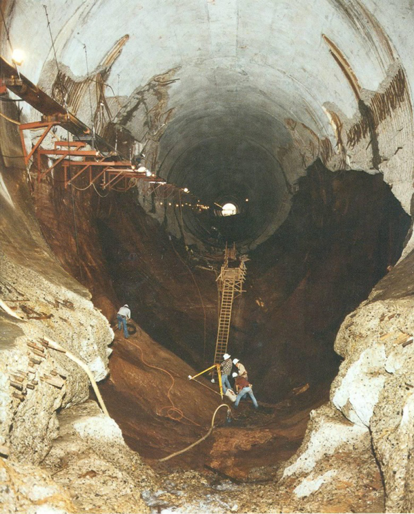
The problem was caused by cavitation: collapsing vapor bubbles in the water sent shockwaves through the tunnel’s innards, tearing through the concrete and then the sandstone, potentially threatening the dam, itself. Engineers had to shut off the flow into the spillways in order to assess and repair the damage inside. That was easier said than done: The lake was so full the water was spilling over the top of the spillway gates. Engineers—the stars of the 1983 disaster documentary—scrambled to find a solution.
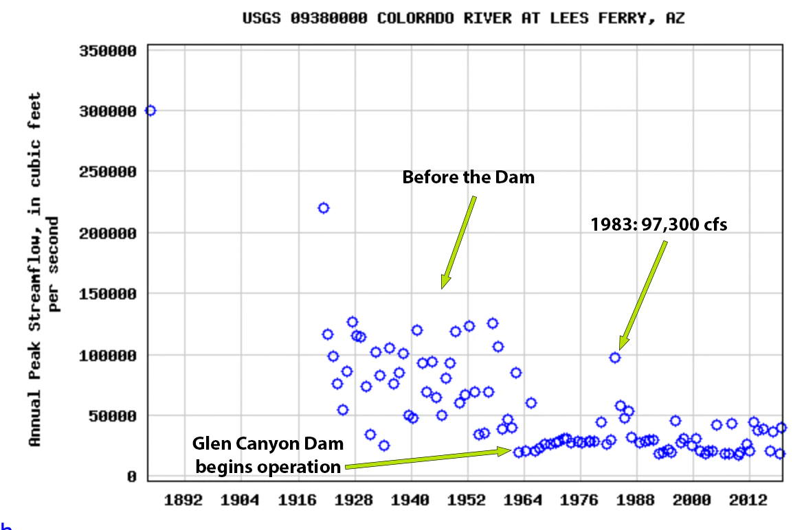
Peak streamflow levels at Lee’s Ferry, just below Glen Canyon Dam. Before the dam, 100,000 cubic feet per second was common. Source: USGS.
When officials from the seven Colorado River states got together in 1922 to parcel out the river’s water, they assumed that some 15 million acre feet of water passed by the Lee’s Ferry dividing point each year, on average, based on a couple decades of streamflow measurements. When Mexico joined the party they simply added another 1.5 million acre feet. This turned out to be a significant overestimate: Tree ring studies later found that the historic average was closer to 14 million acre feet or even lower, which amounts to hundreds of billions of gallons less than was parceled out to the states.
For decades, this wasn’t cause for too much alarm. After all, that’s what dams are for, to store up water during the soggy years to carry users through the dry times. While this became more challenging as the Southwest’s population and water consumption boomed2, it generally worked. The bountiful 1980s filled Lake Powell to the brim. An ensuing string of dry years drew the surface level down nearly 100 feet, but it quickly rebounded when the snows returned in the mid-1990s. Glen Canyon Dam was doing its job, storing water while also churning out gobs of power to keep a burgeoning number of air-conditioners humming.
But over the last two decades, the dam’s storage and power-generation capacities have been compromised as climate change-induced drought shrinks the reservoir behind it. Lake Powell’s surface level has trended downward since 2001, with a brief respite in 2011. Last July it dropped below 3,555 feet—or 153 feet below the 1983 peak—the lowest since it was filling up in the 1960s and ‘70s. Since then it has continued to plummet and in mid-April appeared to level out at 3,522 feet.
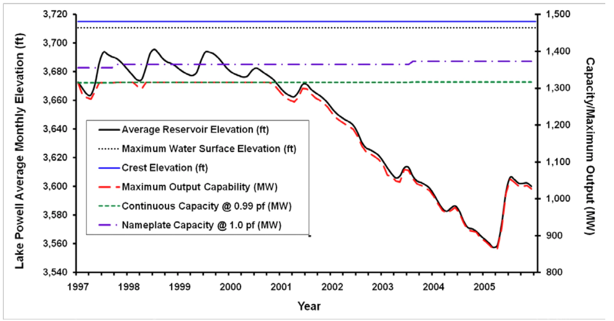
Power output at Glen Canyon Dam, 1980-2005. Note how the abundant water years of 1983-1986 were also big power years. Source: Argonne National Laboratory
As water levels drop the hydropower “head” does, too, thereby decreasing the potential energy of the falling water, which in turn lowers the generating capacity of the turbines. In other words, as Lake Powell shrinks, more water must be released to generate the same amount of power, which further lowers the lake level, and so on. In the 1990s, the dam produced as much as 7,000 gigawatt hours per year, enough to power nearly 600,000 homes. Last year, it was down to just 3,000 gigawatt hours. This phenomenon has forced Western Area Power Administration, the federal governmental organization that markets Glen Canyon Dam’s power at lower-than-market rates, to purchase more expensive power from the open market, driving up its customers’ costs.
Output capacity of the dam’s turbines decreases in direct proportion to the reservoir’s surface elevation. As Lake Powell Shrinks, the dam generates less power. Source: Argonne National Laboratory.
But this chronic decline in generating capacity is about to become more acute—and potential fodder for a new disaster documentary. If the reservoir’s level drops another 33 feet, to the 3,490-foot minimum power pool level, air could get entrained in the turbine-feeding penstocks, wreaking all kinds of havoc. At that point, or perhaps even sooner, operators have no choice but to stop sending water through the turbines, killing power generation and depriving the grid of enough electricity annually to power about a quarter of a million Arizona homes. It would also drain between $100 million and $200 million annually from dam electricity sales
That would force WAPA to purchase more expensive power, including electricity generated from natural gas or even coal, to supply its millions of customers. The average utility customer might not even notice the dollar or two this adds to their monthly bill, but it could amount to a substantial price hike for the tribal nations that rely on WAPA for most or all of their power. The Navajo Tribal Utility Authority’s yearly power bill could jump by as much as $1.3 million, according to a 2016 consultant’s study, and nine other tribes would also see significant cost increases.
Equally worrisome is how grid operators will fill the generation void left when the dam goes offline. New wind and solar power, paired with batteries or other energy storage, can replace some or all of the baseload power. But any extra generation capacity is going to be in high demand as big coal and nuclear plants retire in the next few years. Meanwhile, solar and wind can’t follow loads like a hydroelectric dam, so utilities are likely to turn to greenhouse gas-emitting natural gas “peaker” plants instead.
Then there’s the impact to the dam itself. Once the turbines are shut down, the only way water can be released is via the concrete river outlets, also known as “jet tubes” because they spray water into the riverbed like giant firehoses. These tunnels have only been used for short stints during the 1983 and 1984 high water years and for experimental high-flow releases intended to mimic natural river conditions and redistribute sediment in the Grand Canyon. No one knows how long they can be run at full throttle before cavitation begins.
“Glen Canyon Dam was not envisioned to operate solely through the outworks for an extended period of time,” wrote Tanya Trujillo, the Interior Department’s assistant secretary for water and science, in a letter to Colorado River state governors earlier this month, “and operating at this low lake level increases risks to water delivery and potential adverse impacts to downstream resources and infrastructure.” If levels drop much lower, the City of Page and the LeChee Chapter of the Navajo Nation would lose their Lake Powell drinking water supply.
“Glen Canyon Dam facilities face unprecedented operational reliability challenges,” Trujillo added. In other words, maybe it will all be fine. Or, maybe, it will be like 1983 all over again.
Cavitation at the Glen Canyon Dam, the cause of the emergency in 1983 via Flow Science.
The Challenge at Glen Canyon ends on a triumphant note, major-chord music blaring in the background. The engineers jerry rigged a fix for the spillways, extending the gates’ heights with plywood, then steel, plates. They held until the raging Colorado River calmed down and the crisis was averted. Inside the tunnel workers found huge fissures in the concrete and rock and set about building an aeration slot along the tunnel floor to prevent cavitation in the future.
The multi-million-dollar upgrades3 completed after the near-disaster, the narrator says, marked, “a victory for the human spirit, for the leaders who cut through the red tape … for the men and women who worked long hours and did the job. The American people who own this dam and Lake Powell can be confident that when the flood waters run down the Colorado, Glen Canyon Dam will be ready.”
The engineers are scrambling again, this time hoping to delay the dip into minimum power pool territory. Last fall the Bureau of Reclamation upped releases from upstream dams to try to keep Powell’s levels from dropping into the 35-foot buffer zone, draining Western Colorado’s Blue Mesa Reservoir to all-time lows in the process. Although the move failed to stop Lake Powell’s decline, it did slow it down, giving water managers more time to consider their options. This winter and spring they released less water than normal from Glen Canyon Dam, hoping to make up for it during spring runoff.
Nevertheless, outflows consistently have exceeded inflows, evaporation continues, snowpack is below median levels in the Upper Colorado watershed, and lake levels have dropped a total of 41 feet over the last year. Now water officials are exploring ways to modify the dam to enable it to continue producing power at lower levels—possibly by adding turbines to the river outlets—a sort of modern version of the plywood spillway gates of yore. And in the aforementioned letter, Trujillo floated the possibility of cutting overall releases this year to just 7 million acre feet, about 1 million less than normal, and a half-million less than planned this year, which would then cause Lake Mead’s levels to drop even further and could spur further cutbacks for downstream water users.
Unlike the floods of 1983 and 1984, the real disaster looming over the region today—human caused climate change and long-term aridification—is not going to subside in a month or year or even a decade. The question now is not whether Glen Canyon Dam will be prepared, it will not. Lake Powell will reach the dreaded dead pool, when the lake falls so low water cannot be released except by pumping it out or re-opening the tunnels excavated to divert the river during dam construction. Maybe it will happen in five years, maybe 20, but it’s coming. The real question is whether we, the residents of the West who rely on the Colorado River—and Glen Canyon Dam—for so much, will be ready for the inevitable.
(1) During the 1980s dam operators had ample leeway to “follow the load” by modulating the flow of water through the turbines. This occasionally caused huge fluctuations in the flow of water through the Grand Canyon. On one July day in 1989, for example, about 3,471 cubic feet of water per second was running through the dam at 5 a.m. By 3 p.m., it had jumped to 29,000 cfs—the maximum flow through the turbines—to provide juice to the Southwest’s power grid to keep all those air conditioners running. If you’re a river runner, you can probably imagine how disruptive—and even terrifying—this might have been to boaters in the Grand Canyon. In the early ‘80s dam operators wanted to maximize the potential for following the load by also installing turbines in the river outlets so they could generate even more power by releasing more water. The proposal was shot down and set off a string of events that ultimately led to significant changes in the way the dam is operated, including minimum and maximum release rates and maximum fluctuation rates, thereby limiting its capacity as a “peaker” plant.
(2) Water demand on the Colorado has increased substantially since the Colorado River Compact was signed, obviously, and continued to climb up until the late 1990s, when it plateaued and even dropped with the onset of the current megadrought in the early 2000s.
Consumptive water uses and losses on the Upper Colorado River Basin. Source: USBR
(3) The estimated cost to repair both spillways was about $30 million, according to one estimate, but this was offset by the $34 million in electricity sales revenue generated by running the turbines at full throttle for a good part of the summer.
Click the link to read the newsletter on the Middle Colorado Watershed Council website (Click through and volunteer to do some sampling or whatever.). Here’s an excerpt.:
The Colorado Water Conservation Board (CWCB) has granted three more years of funds to the Middle Colorado Watershed Council (MCWC) to continue the United States Geological Survey (USGS) water quality and rain gauge monitoring set up in 2021, adding new mid-stream water quality monitoring stations between South Canyon and Cameo, soil moisture monitoring, and a dashboard notification system for downstream municipalities.
The Colorado River District has agreed to serve as fiscal agent for the USGS in a three-year cooperative agreement with MCWC. The $583,396 CWCB grant will be matched with in-kind labor and cash from the USGS, Garfield County, the Glenwood Canyon Restoration Alliance, and coordinated project funding from the Colorado Department of Public Health and Education (CDPHE) for a total project cost of $1.3 million over the next three years.
Funding secured from CDPHE, $206,600, will be used to purchase the additional equipment needed for the new mid-stream water quality station, soil moisture monitors, and the user-friendly dashboard for downstream users to monitor changes in water quality and rainfall information. The CDPHE funding will also support pre-fire mitigation planning and allow the Silt Water Conservancy District to complete repair work from damage due to the continual impact of high amounts of sediment in the Colorado River in 2021.
Since early 2021, the Middle Colorado Watershed Council has coordinated post Grizzly Creek Fire water quality and rain gauge monitoring to set up a regional notification system and lessen the impact on downstream water users. MCWC received the first year of funding from CWCB, CDPHE and the Colorado River District’s Community Partnership Funds.
Using services from the USGS Colorado Water Science Center, the USGS Next Generation Water Observing System (NGWOS), and SGM, an engineering firm acting as MCWC’s technical advisor, water quality and precipitation information networks were set up in canyon drainages and on the Middle Colorado river corridor. Seven rain gauges were deployed throughout the Grizzly Creek burn area and a 6-parameter data sonde water quality monitoring station was set up at No Name.
During the summer of 2021, summer monsoons caused flooding, debris flows and highway infrastructure damage in Glenwood Canyon as a result of the 2020 Grizzly Creek fire burn scar and a 500-year-rain event. MCWC and other stakeholders expect continued problems with flooding and debris flows from these canyon drainages over the next few years and sought the additional funding to continue and expand monitoring in 2022 through 2024.
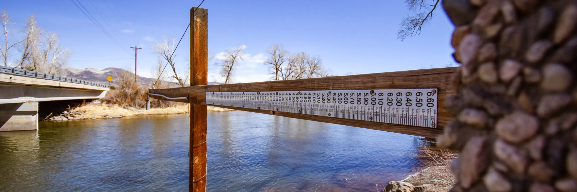
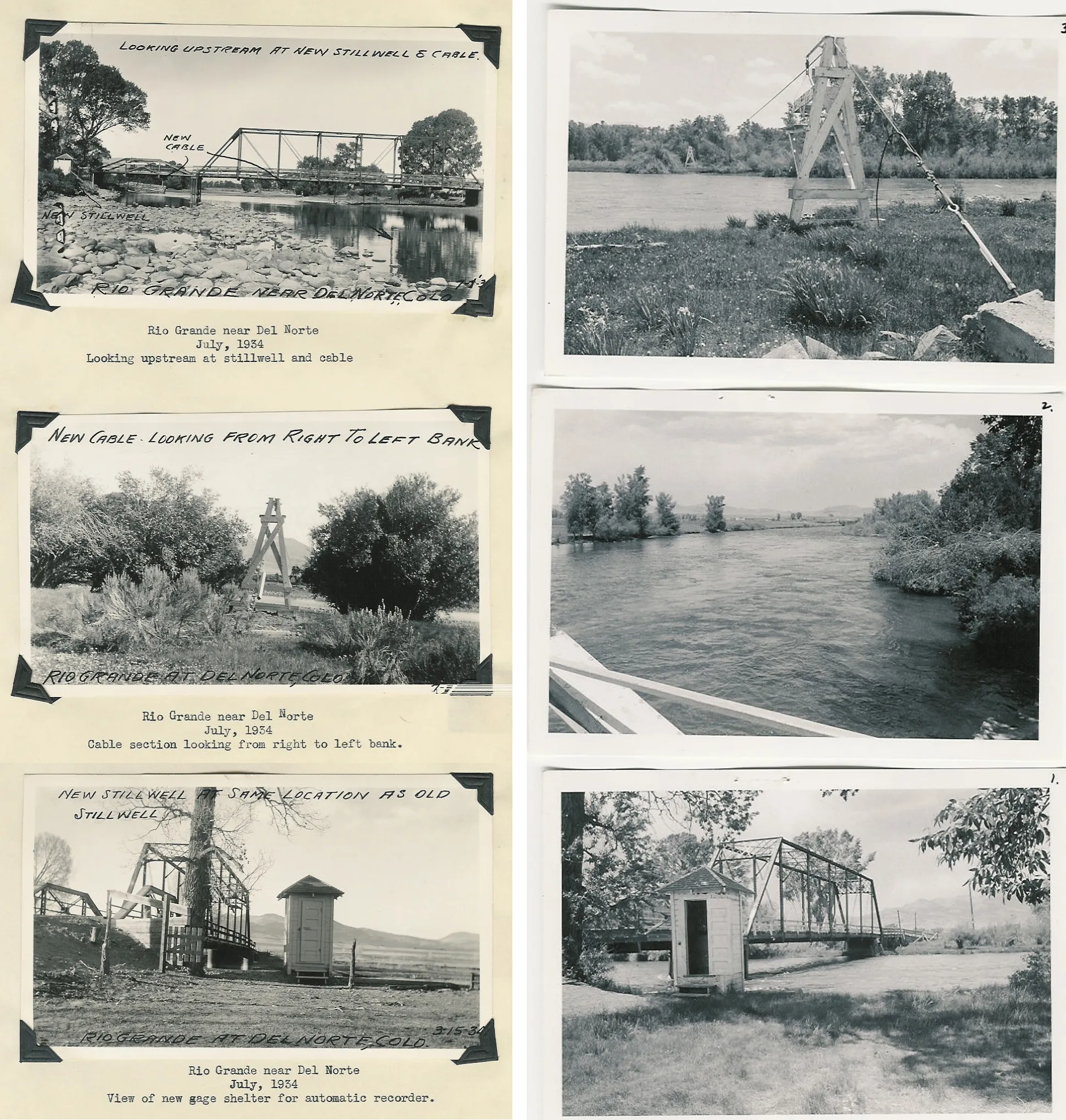
It’s a commonly known spot off County Road 17 between Del Norte and South Fork. Driving in you might see a blue heron standing off in the marsh and river rafters looking to get onto the Rio Grande at the very spot Colorado has been measuring the river since the summer of 1889 – June 1, 1889, to be precise.
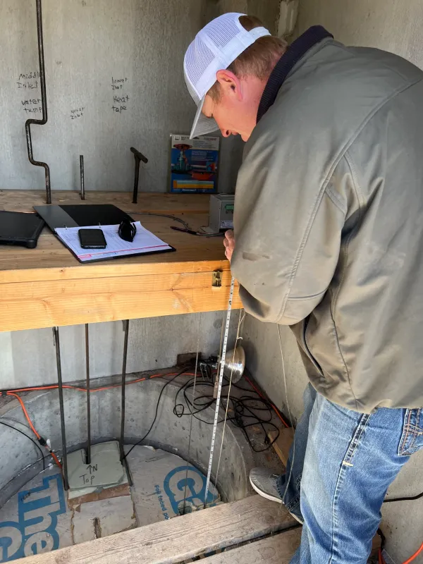
This time of year, with any ice on the river gone and the weather warming, Jessie Jaminet comes every two weeks to the stream gaging station operated by Colorado Division of Water Resources to make sure everything is functioning for measurements that are closely watched by water managers up and down the Rio Grande. He was there this past week to get an early spring reading and when prompted for a prediction on this year’s flows said, “I think we’re probably going to be slightly below average from what I’ve seen.”
1934 and 1960. Credit: Alamosa Citizen
Average over the past decade has been 491,000 acre-feet of water; historically going back to 1889 the Rio Grande has an average measurement of 639,000 acre-feet, according to figures maintained by the state.
Jaminet, lead hydrographer for state water resources division 3, cautions that the river “changes daily right now.”
“Any storm that hits right now is a huge benefit for the whole system. People watch the snowpack numbers, but it really depends on what happens this time of year. Wet spring storms really benefit the system,” he said.
The Rio Grande gaging station near Del Norte is the highest profile gage station in the Upper Rio Grande Basin. That’s because it’s the gaging station the state uses to help determine how much water from the Rio Grande is available and will be delivered downstream into New Mexico and Texas as part of the three-state Rio Grande Compact.
Besides measuring lower-average acre-feet the past decade, another phenomenon has been occurring: an earlier peak to the river flow and then a quick dropoff, which means less water and shorter irrigation seasons downstream for New Mexico and Texas.
The stream gaging station operated by Colorado Division of Water Resources highway 17 between Del Norte and South Fork. Photo credit: Alamosa Citizen
“Historically the river would peak and we would maintain those flows for a while before we would fall into base flow conditions,” Jaminet said. Peak flow used to hit mid- to late-June and the Rio Grande would maintain itself through the summer. Now the state is seeing peak Rio Grande flows as early as late May and then drastic drop offs to the height of the river. It’s attributable to the aridification of the Valley floor from persistent drought and climate change.
Colorado’s obligations under the Rio Grande Compact is another aspect to the management of the upper basin of the river that water managers, irrigators, and outdoor recreationalists have to factor in when planning their own water usage.
“This is what we base pretty much all of our numbers on, this upper index here. Anything that passes this gage here we have to deliver a percentage of it downstream. This is why this is an important gage here,” said Jaminet.
He’s been working the measurements the past 15 years as part of his job with Colorado Division of Water Resources to operate and maintain the gaging stations along the Upper Rio Grande Basin. It’s not what he planned on doing for a career when he graduated from Mountain Valley High School in Saguache in 2001 and then the University of Wyoming, where he majored in rangeland geology and watershed management. But he’s learned and come to understand the importance of taking the river’s measurement, and the fact he grew up in the San Luis Valley makes him appreciate the work he does even more.
“This is a continuous record that we produce here,” he said of the Del Norte gaging station, pointing to the readings from 1890 through 2021. One of the most eye-popping historical figures is Oct. 5, 1911, when the Rio Grande was flowing at 18,000 cubic feet per second. The day Jaminet was at the gage station the river was moving at 519 cfs.
Most of the big diversions to the Rio Grande happen a bit farther downstream in Rio Grande and Alamosa counties, making the gaging station near Del Norte a natural location to determine the depth and velocity of the river.
A float sitting in a stilling well reads the height of the river. Photo credit: Alamosa Citizen
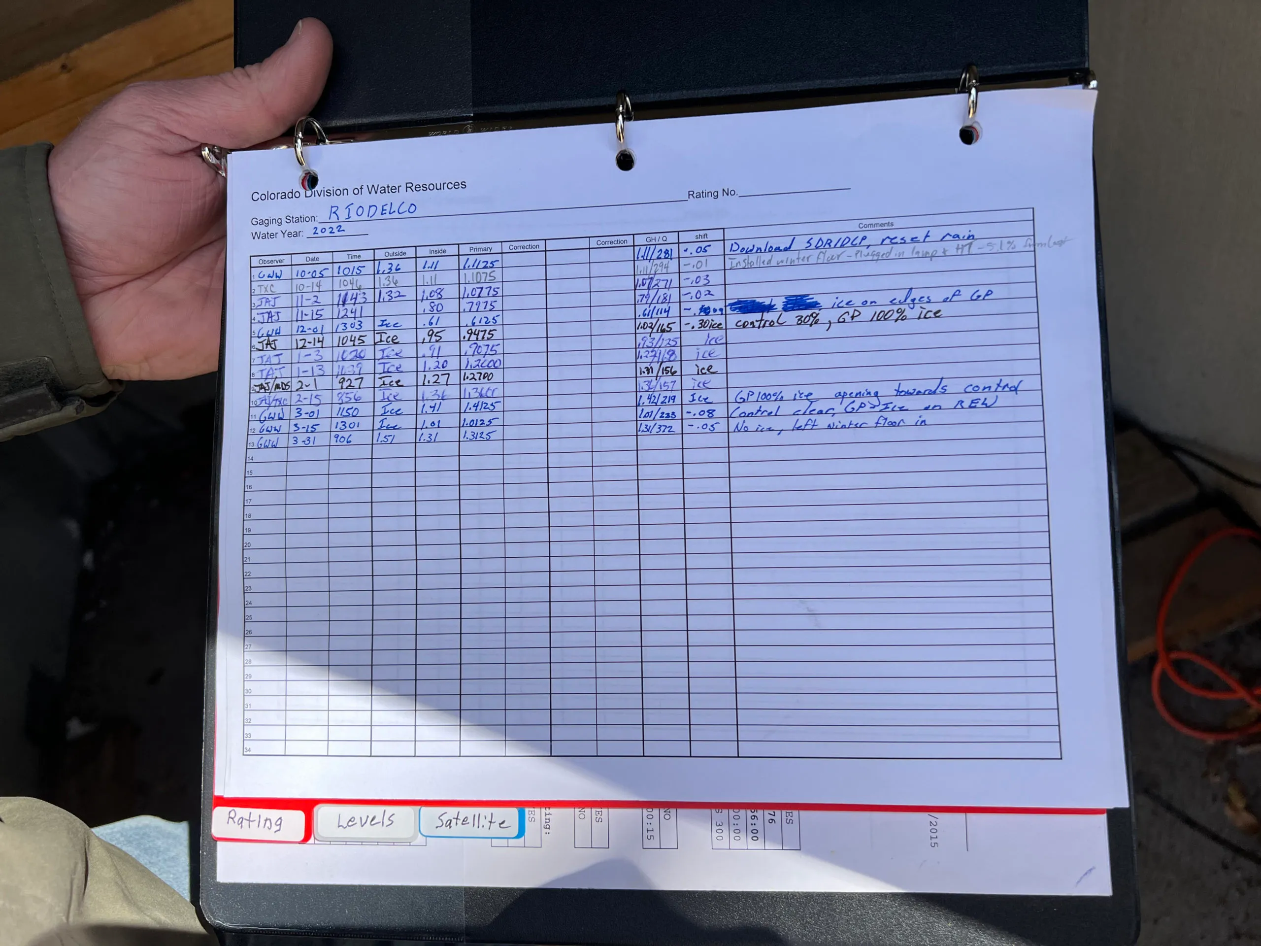
In the 1890s and early decades of the 1900s the state division of water resources would take a measurement of the Rio Grande twice a day and then daily as it kept improving the system. It eventually installed a continuous reader in 1983, and then in the summer of 1984 a satellite monitoring system was installed.
Now the gaging station takes a reading every 15 minutes and logs and transmits the data every hour to the Colorado Division of Water Resources website, where it’s tracked and followed by the three states party of the Rio Grande Compact. Fishermen and rafters will also monitor the web site to help them determine the best times to fish and float the river.
One of Jaminet’s responsibilities is to make sure the gaging station is calibrated and reading accurately. A float sitting in a stilling well reads the height of the river and then a rating table unique to the gaging station is applied to give an accurate measurement. In the winter months, with ice on the river, the measurements are more estimates.
Coming off a dry 2021, in January the Rio Grande was at its lowest point to start a year since Colorado began taking measurements 132 years ago. A cooler March and April have helped, but without significant summer rain, the Rio Grande will run dry again early in the summer irrigation season.
“If you go into the fall really dry, even if you get these big spring storms it seems like it just goes into the ground,” Jaminet said. “A lot of it is not making it to the river anymore.”
The measurements at the Rio Grande gaging station near Del Norte tell the story.
Jaminet makes regular checks on calibration. Photo credit: Alamosa Citizen