Click the link to read the article on the EPA website:
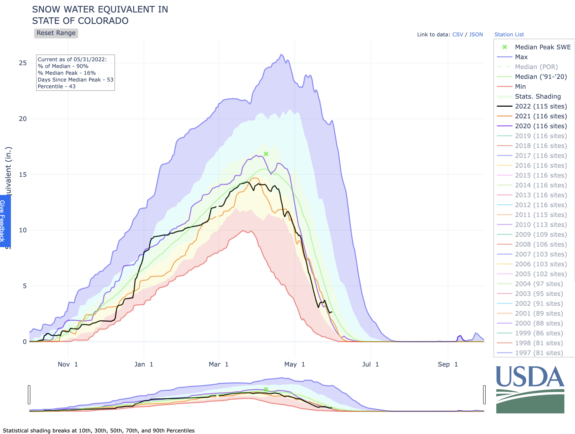
This indicator measures trends in the amount and timing of snowpack in the western United States.
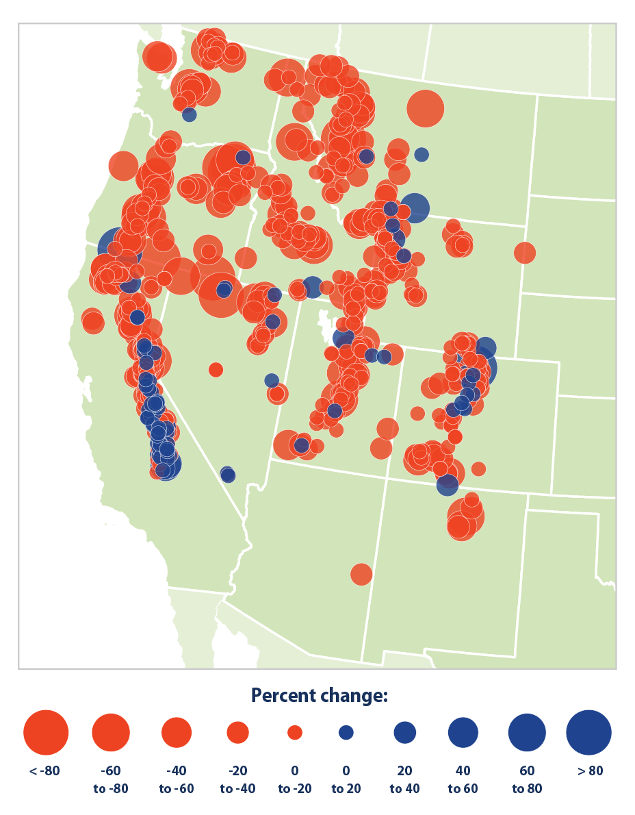
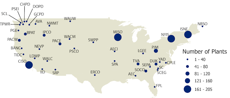
Figure 1. Trends in April Snowpack in the Western United States, 1955–2020
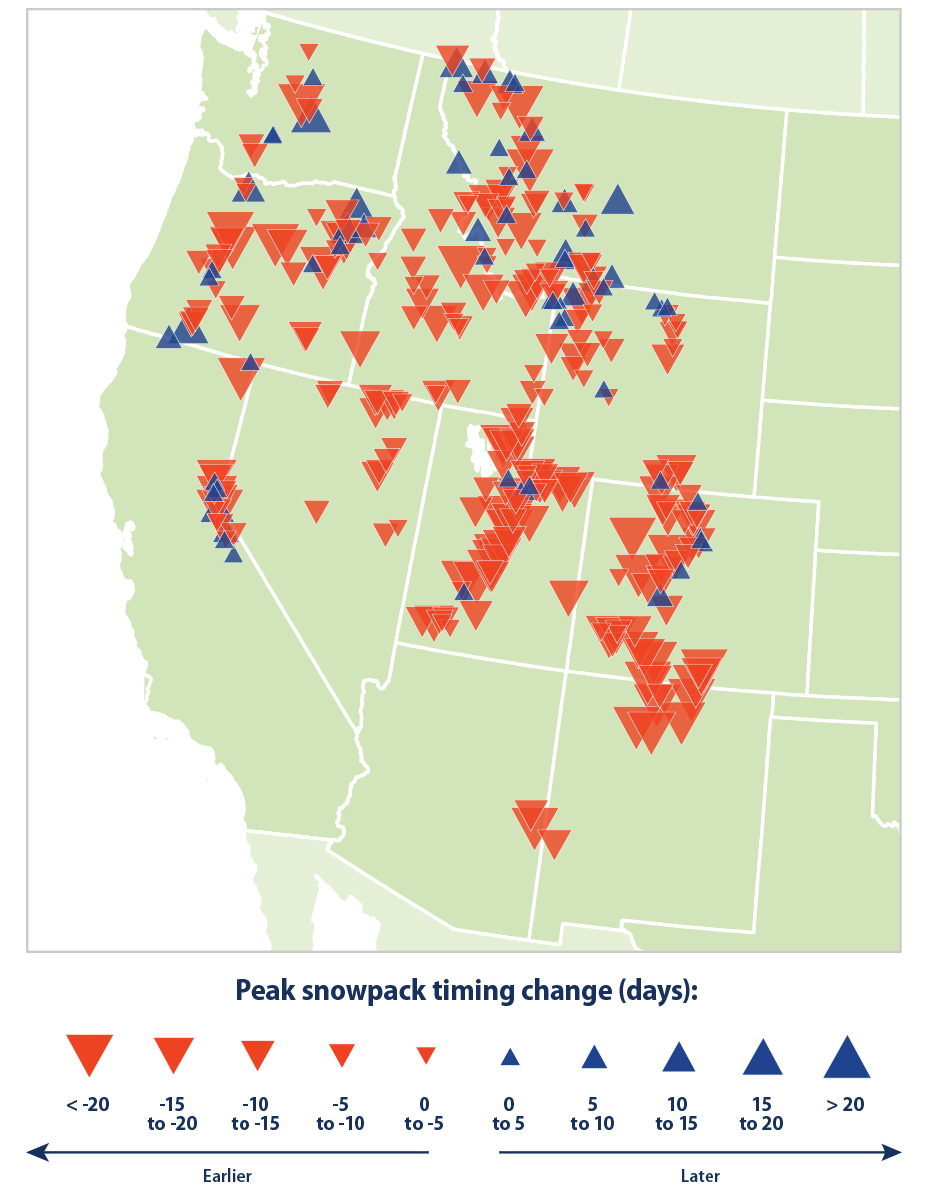
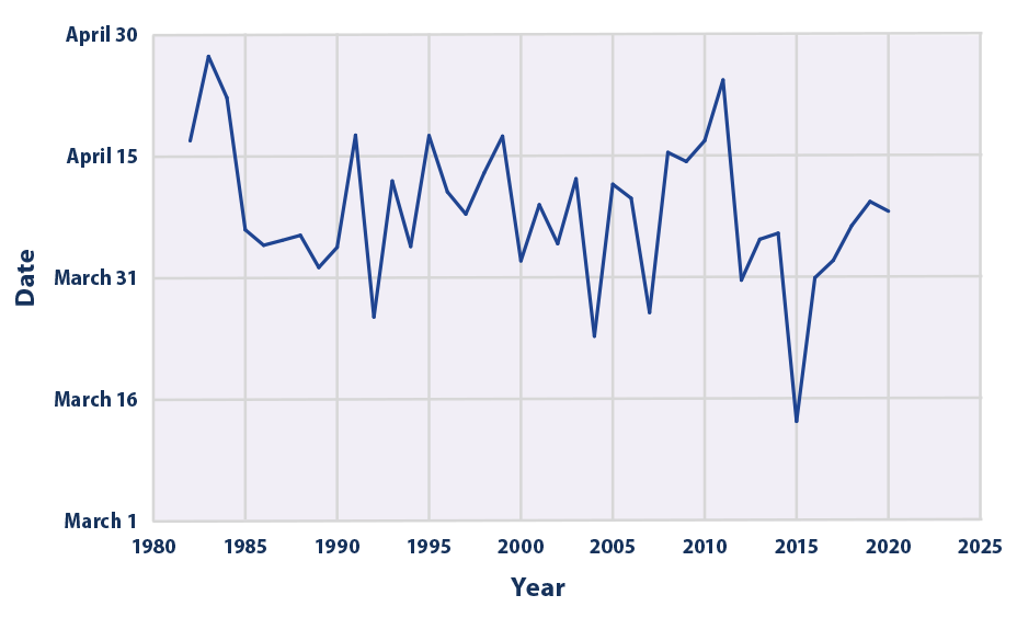
This map shows trends in April snowpack in the western United States, measured in terms of snow water equivalent. Blue circles represent increased snowpack; red circles represent a decrease. Data source: USDA Natural Resources Conservation Service, 20205 Web update: April 2021Figure 2. Change in Peak Snowpack Timing in the Western United States, 1982–2020Figure 3. Average Date of Peak Snowpack in the Western United States, 1982–2020
Key Points
From 1955 to 2020, April snowpack declined at 86 percent of the sites measured (see Figure 1). The average change across all sites amounts to about a 19 percent decline.
Large and consistent decreases in April snowpack have been observed throughout the western United States (see Figure 1). Decreases have been especially prominent in Washington, Oregon, northern California, and the northern Rockies.
While some stations have experienced increases in April snowpack, all 12 states included in this indicator experienced a decrease in snowpack on average from 1955 to 2020 (see Figure 1). In the Northwest (Idaho, Oregon, Washington), all but four stations saw decreases in snowpack over the period of record.
About 81 percent of sites have experienced a shift toward earlier peak snowpack (see Figure 2). This earlier trend is especially pronounced in southwestern states like Colorado, New Mexico, and Utah. Across all stations, peak snowpack has shifted earlier by an average of nearly eight days since 1982 (see Figure 3), based on the long-term average rate of change.
Background
Temperature and precipitation are key factors affecting snowpack, which is the amount or thickness of snow that accumulates on the ground. In a warming climate, more precipitation will be expected to fall as rain rather than snow in most areas—reducing the extent and depth of snowpack. Long-term observations across the contiguous 48 states show that nearly 80 percent of weather stations examined have experienced a decrease in the proportion of precipitation falling as snow (see the Snowfall indicator). In addition, with warmer winters and springs (see the Seasonal Temperature indicator), the seasonality of snowpack is also changing. Higher temperatures cause snow to melt earlier, which in turn affects the timing and availability of water.
Mountain snowpack plays a key role in the water cycle in western North America, storing water in the winter when the snow falls and releasing it as runoff in spring and summer when the snow melts. Millions of people in the West depend on the melting of mountain snowpack for hydropower, irrigation, and drinking water. In most western river basins, snowpack is a larger component of water storage than human-constructed reservoirs.1 Continued reductions in snowpack and shifts in snowmelt are expected in the future, which will reduce hydropower production in the Southwest and the Northwest.
Changes in mountain snowpack can affect agriculture, winter recreation, and tourism in some areas, as well as plants and wildlife. For example, certain types of trees rely on snow for insulation from freezing temperatures, as do some animal species. In addition, fish spawning could be disrupted if changes in snowpack or snowmelt alter the timing and abundance of streamflows. (For a look at long-term trends in the timing of spring snowmelt runoff in United States, see the Streamflow indicator.) Additionally, warming and earlier snowmelt accelerate the start of the wildfire season and promote more wildfire activity in the western United States and Alaska (see the Wildfires indicator). Altogether, snowpack’s sensitivity to climate and its many related effects make this a valuable indicator to track.
About the Indicator
This indicator uses a measurement called snow water equivalent to determine trends in snowpack. Snow water equivalent is the amount of water contained within the snowpack at a particular location. It can be thought of as the depth of water that would result if the entire snowpack were to melt. Figure 1 shows long-term rates of change for April 1, the most frequent observation date, because it could reflect changes in precipitation, and it is extensively used for spring streamflow and water supply forecasting. Figures 2 and 3 focus on the day of each year when snowpack is at its deepest (that is, peak snowpack) to determine if it is occurring earlier or later.
The U.S. Department of Agriculture and other collaborators have measured snowpack since the early 1900s. In the early years of data collection, researchers measured snow water equivalent manually, but since 1980, measurements at some locations have been collected with automated instruments as part of the snow telemetry (SNOTEL) network. The long-term analysis in Figure 1 is based on data from nearly 700 permanent measurement sites in the western United States. The peak snowpack analysis shown in Figures 2 and 3 requires daily measurements, so it uses a smaller set of 328 SNOTEL sites that have data since 1982, which is when a large number of SNOTEL devices were deployed and came online.
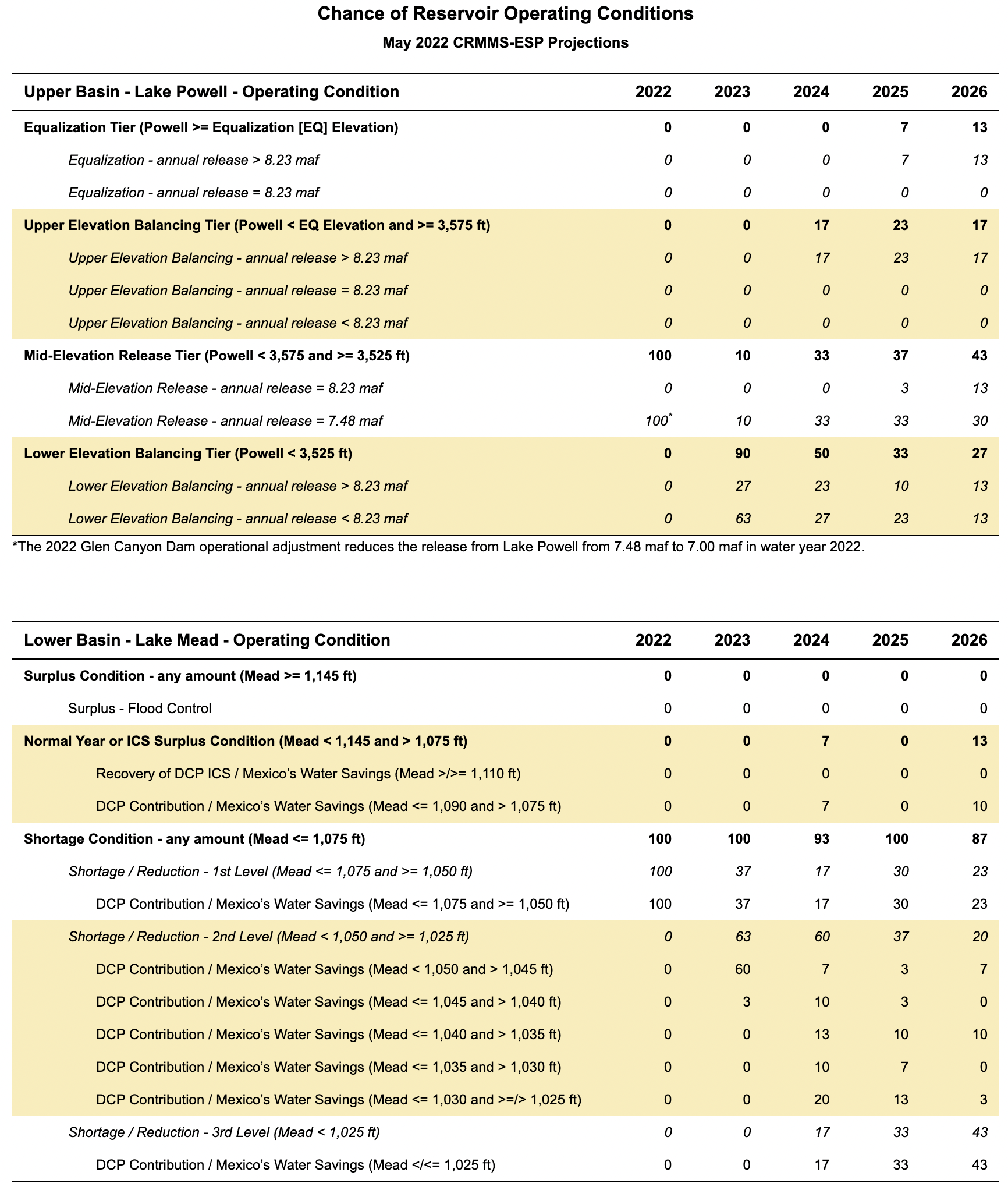
-NEW- In light of the prolonged drought, low runoff conditions, and depleted storage at Lake Powell, the Department of the Interior implemented an action under Sections 6 and 7.D of the 2007 Interim Guidelines specifically reducing the Glen Canyon Dam annual releases to 7.00 maf in water year 2022. This action was undertaken in conjunction with 2022 Drought Response Operations Plan actions, which includes an additional 500 kaf release from Flaming Gorge. Together these actions are anticipated to add approximately one million additional acre-feet of storage to Lake Powell by April 2023.
The reduction of releases from Lake Powell from 7.48 maf to 7.00 maf in water year 2022 will result in a reduced release volume of 0.48 maf that normally would have been released from Glen Canyon Dam to Lake Mead as part of the 7.48 maf annual release volume, consistent with routine operations under the 2007 Interim Guidelines. The reduction of releases from Glen Canyon Dam in water year 2022 (resulting in increased storage in Lake Powell) will not affect future operating determinations and will be accounted for “as if” this volume of water had been delivered to Lake Mead.
Overview
Five-Year Probabilistic Projections of future conditions in the Colorado River system currently extend through 2026. They are typically updated every January, April, and August, while probabilistic results for the 2-year period are updated every month. The 5-Year Probabilistic Projections are generated using the Colorado River Mid-term Modeling System (CRMMS) in Ensemble Mode. CRMMS Ensemble Mode is driven by an ensemble of monthly unregulated streamflow forecasts developed by the National Weather Service Colorado Basin River Forecasting Center (CBRFC) using the Ensemble Streamflow Prediction (ESP) method. Results from CRMMS run with ESP are referred to as CRMMS-ESP.
The most recent 5-year projections of future Colorado River system conditions were produced using the following assumptions:
Initial Conditions: CRMMS is initialized with previous end-of-month reservoir elevations.
Hydrology: Upper Basin inflows are 30 unregulated inflow forecasts traces produced by the CBRFC using the ESP method, which relies on observed temperature and precipitation from 1991-2020. Lower Basin inflows are the historical intervening flows from 1991-2020 that align with the ESP traces.
Water Demand: Upper Basin demands are estimated and incorporated in the unregulated inflow forecasts provided by the CBRFC; Lower Basin demands are developed in coordination with the Lower Basin States and Mexico.
Policy: 2007 Interim Guidelines, Lower Basin Drought Contingency Plan, and Minute 323 are modeled reflecting Colorado River policies.
Drought Response Actions: CRMMS projections contain actions undertaken with the 2022 Drought Response Operations Plan and 2022 Glen Canyon Dam operational adjustment.
The 2022 Drought Response Operations Plan includes an additional release of 500 kaf from Flaming Gorge from May 2022 through April 2023.
The 2022 Glen Canyon Dam operational adjustment reduces the releases from Lake Powell from 7.48 maf to 7.00 maf in water year 2022. This will result in a reduced release volume of 0.48 maf that normally would have been released from Glen Canyon Dam to Lake Mead as part of the 7.48 maf annual release volume, consistent with routine operations under the 2007 Interim Guidelines. The reduction of releases from Glen Canyon Dam in water year 2022 (resulting in increased storage in Lake Powell) will not affect future operating determinations and will be accounted for “as if” this volume of water had been delivered to Lake Mead. Recognizing that operational decisions for 2023 and beyond have not been made, for all hydrologic scenarios that project Glen Canyon Dam to operate in a balancing condition in a future water year, releases are simulated in a manner that attempts to preserve the benefits to Glen Canyon Dam facilities and operations.
Additional details are available in CRMMS Ensemble Mode page. All modeling assumptions and projections are subject to varying degrees of uncertainty. Please refer to this discussion of uncertainty for more information.
Projections
5-Year Probabilistic Projections presented in the tables below are reported as the percentage of projected Lake Powell and Lake Mead operations that fall below critically low elevations or are within each operational tier in the next five years.
Click the graphic to enlarge.Click the graphic to enlarge.
Click the link to read the article on The Denver Post website (Judith Kohler). Here’s an excerpt:
The result of the highly engineered systems and technology is fresh, nutritious and non-genetically-modified food, said Aric Nissen, chief marketing officer for Kalera, a Florida-based company that builds and operates indoor, vertical farms.
The company began operations about a month ago in a 90,000-square-foot warehouse, which Nissen estimates is running at 30% capacity. In the next several months, Kalera expects to expand its workforce of 40 to about 100 and its operations to full capacity to harvest approximately 15 million heads of lettuce, or 2.5 million pounds…
“We’re trying to produce food at scale in an urban area, close to where people live,” Nissen said. “We want to let people know there’s technology involved, but it’s producing food naturally, without the use of chemicals or genetic modification.”
Kalera’s farms use hydroponics — water — to grow lettuce and microgreens, or vegetable seedlings. The New York Times reports the number of vertical farms is expected to expand as demand for year-round produce and the impact of climate change on agriculture increase. The industry is forecast to grow globally from $3.1 billion in 2021 to $9.7 billion by 2026, according to the data analysis company ResearchandMarkets.com.
Native land loss 1776 to 1930. Credit: Alvin Chang/Ranjani Chakraborty
Click the link to read the article on the Colorado Public Radio website (Michael Elizabeth Sakas). Here’s an excerpt:
The Colorado Water Congress has voted to expand its board to include representatives of Native American tribes for the first time…
Executive Director Doug Kemper said the nonprofit group has about 350 organizations as members, ranging from water utilities like Denver Water to agricultural and environmental groups. The policy and planning group is governed by a board of directors who are supposed to represent the different geographical areas and water users of the state. But the Native American tribes in Colorado, the Southern Ute Indian Tribe and the Ute Mountain Ute Tribe, weren’t included.
The board recently voted to change its bylaws to include tribal representatives as board members. Kemper said the move would give other group members a chance to listen and better understand the tribes’ needs and concerns.
“They’re both sovereign nations,” Kemper said. “They have distinct priorities themselves on water matters.”
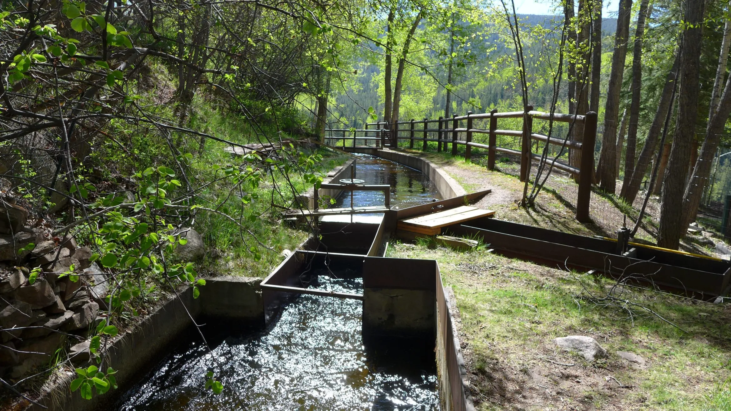
This Parshall flume on Red Mountain measures the amount of water diverted by the Red Mountain Ditch. Pitkin County commissioners approved a roughly $48,000 grant to pipe the last 3,600 feet of the ditch in the Starwood neighborhood. CREDIT: HEATHER SACKETT/ASPEN JOURNALISM
The Pitkin County Board of County Commissioners has approved one year of funding toward completing a ditch piping project with the aim of keeping more water in Hunter Creek.
Over the past two decades, the Red Mountain Ditch Company has been working to pipe the entirety of its 12-mile ditch system — a $3.8 million cost so far — paid for by the ditch share owners. But to complete the final 3,600 feet, the ditch company is turning to public sources of money because they say the project will have the public benefit of keeping between 0.5 and 1 additional cubic feet per second of water in Hunter Creek.
The Pitkin County Healthy Rivers board recommended the county grant nearly $48,000 toward the project in April and county commissioners approved the request on Tuesday.
“I think this is the first time when I’ve been on the board that I’ve seen this type of project and I really think it’s valuable,” said commissioner Kelly McNicholas Kury. “It’s a conservation-first type of program and to me this is the way I think the treatment of ditches should head in the future around the Western Slope.”
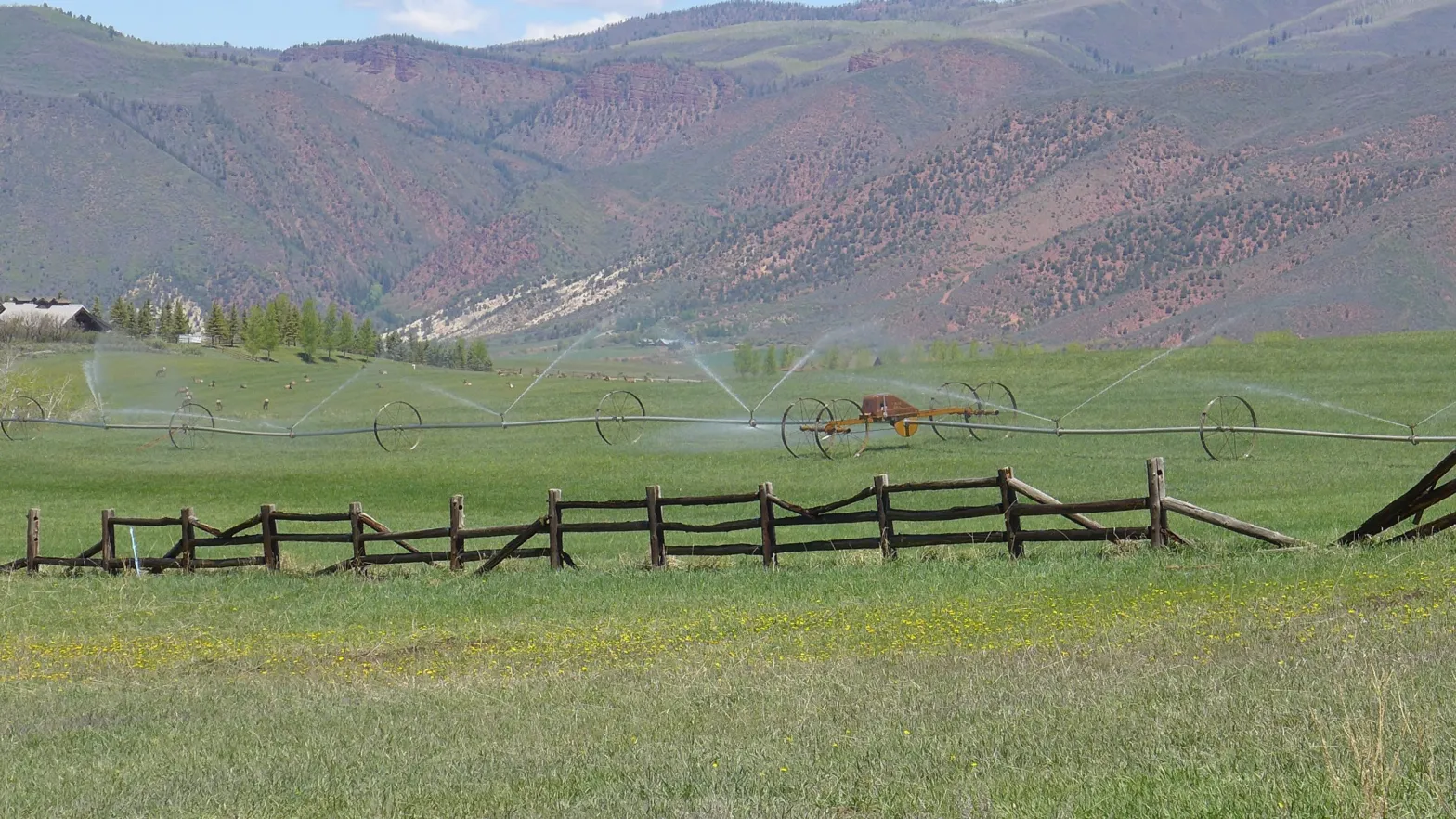
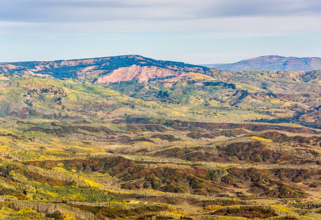
Red Mountain Ditch, whose horizontal scar across Red Mountain features prominently in the view from across the valley, has senior water rights that date to 1889. It irrigates about 380 acres of grass pasture on Red Mountain and in the exclusive Starwood subdivision with water from Hunter Creek.
A herd of elk feast on a sprinkler-irrigated meadow in the Starwood subdivision. The area is irrigated with water from Hunter Creek via Red Mountain Ditch. CREDIT: HEATHER SACKETT/ASPEN JOURNALISM
More water in Hunter Creek
Jim Auster, who has managed the ditch since 1983, said before the capital improvement project, the high-maintenance, open ditch lost water to seepage and evaporation and had problems with blow outs and beaver activity that caused flooding. Now that the majority of the ditch is piped underground, he said it’s easier to get water during low-flow times of year and the company has reduced the amount it diverts from Hunter Creek by up to 6 cfs.
Auster said before the piping project, the ditch used to divert about 14 cfs on average; now it takes about 8 to 9 cfs. Numbers from the Colorado Division of Water Resources indicate the ditch has in fact diverted less in recent years.
“Technologically, we are progressive,” Auster said. “I don’t know of any other ditch company that is doing 100% piping like we are. It’s certainly the future. Open ditches are obsolete.”
Recent ditch inventories conducted by conservation districts across the Western Slope hint at widespread problems, disrepair and inefficiencies with irrigation infrastructure. Environmental groups often back irrigation efficiency projects because they could result in reducing the amount irrigators need to divert, thereby leaving more water in the river to the benefit of the environment.
But repairs and upgrades are often expensive. And most projects don’t put a number on how much water will be left in the stream. In most cases, paying irrigators for their extra water is the only way to ensure an environmental benefit.
Aaron Derwingson, water projects director for The Nature Conservancy’s Colorado River Program, has worked on efficiency projects with irrigators. He said it can be hard to quantify a project’s environmental benefits and success often depends on the willingness of the irrigators.
“I think the challenge with our team that we run into is we are never going to have enough money to buy the water to really make a difference for a lot of streams and where does that leave us?” Derwingson said. “That’s why some of these efficiency projects can be great because it’s a one-time investment and you get continued benefit.”
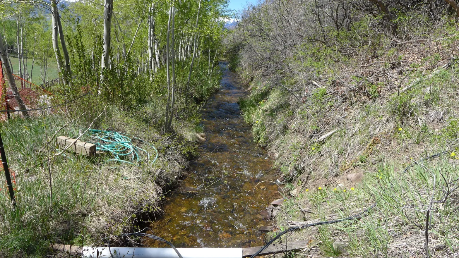
sThis is part of the open ditch through properties in the Starwood subdivision that would be piped if Red Mountain Ditch company can secure the funds. Manager Jim Auster said up to an additional 1 cfs could be left in Hunter Creek if the last 3,600 feet of ditch is piped. CREDIT: HEATHER SACKETT/ASPEN JOURNALISM
How to protect the water
McNicholas Kury brought up an unanswered question in Tuesday’s discussion: how to legally protect the water the piping project leaves in Hunter Creek. Under Colorado water law, another water user could pick up that water and put it to beneficial use, canceling out any environmental benefit to the stream. And as stream flows continue to dwindle due to climate change, an environmental benefit may be short-lived, especially if the water is not legally protected.
“I have some concern about the water that is going into Hunter Creek,” McNicholas Kury said. “That is fantastic; I don’t want others to pick it up along the way.”
McNicholas-Kury suggested the Red Mountain Ditch Company look into an agreement with the non-profit Colorado Water Trust, which helps water rights holders lease their water rights for the purpose of boosting environmental streamflows.
In addition to finishing the piping, Auster said $25,000 of the grant money will go toward installing remote monitoring and headgate controls, which will allow him to be more precise and reduce the amount of excess water that is run through the system.
Auster said the total cost of the project for the final 3,600 feet of piping is $680,000, and the ditch company is also applying for grants from the Colorado River Water Conservation District and the National Resources Conservation Service. The ditch company may return to the county in 2023 and 2024 to request additional funding.
Board of County Commissioners Chair Patti Clapper and Vice-Chair Francie Jacober questioned whether the residents of one of Aspen’s wealthiest subdivisions couldn’t pay for their own ditch piping project, but in the end, backed the grant request.
“The best interest of this community is keeping water in our rivers and that is a benefit to everyone,” Clapper said.
Editor’s note: Aspen Journalism is supported by Pitkin County’s Health Community Fund. Aspen Journalism covers water and rivers in collaboration with The Aspen Times. This story ran in the May 28 edition of The Aspen Times.
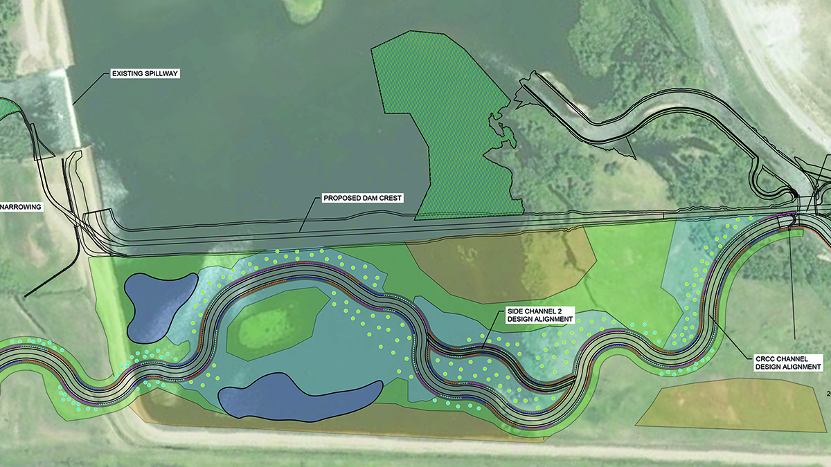
The Natural Resources Conservation Service (NRCS) has released a Finding of No Significant Impact drawn from its Environmental Assessment of the Colorado River Connectivity Channel. The decision paves the way for construction to begin on the project to reconnect the Colorado River through a restored channel around Windy Gap Reservoir in Grand County.
The $30 million project, proposed by the Municipal Subdistrict, Trout Unlimited, Grand County and the Upper Colorado River Alliance, will build a natural river channel around Windy Gap Reservoir for the purpose of improving aquatic habitat in the Fraser and Colorado rivers. The project is expected to reopen the Colorado River to fish passage and improve habitat and water quality in downstream reaches.
“The Colorado River Connectivity Channel is an example of the positive outcomes that can occur when diverse groups come to the table to meet the challenges of delivering a reliable water supply to Colorado residents, all while addressing important habitat in the Colorado River,” said Northern Water General Manager Brad Wind.
Awise man once said, “developers only have to win once; the community has to win every time.” It’s the same with water exportation proposals. The Renewable Water Resources plan suffered a setback when Douglas County chose not to invest with federal COVID money, but the push to export water from the San Luis Valley aquifers is not dead.
“I don’t think anyone should let down their guard and think we ‘won.’” That’s the voice of Karen Hickman, a Douglas County resident who’s been following the discussions in Castle Rock, and who emailed us her thoughts after listening to Monday’s meeting.
She finished by saying, “Commissioner Teal doesn’t like to lose so there must be another plan in the works!”
There is, and Douglas County hired-attorney Steve Leonhardt pointed to it in his first confidential memorandum to the three commissioners on March 23, 2022 when he wrote, “RWR is developing a legislative strategy to address this issue.”
The issue being the required augmentation plan and meeting the rules and regulations governing groundwater withdrawals in the Upper Rio Grande Basin of the high-desert San Luis Valley.
Enter State Sen. Cleave Simpson, who also serves as general manager of the Rio Grande Water Conservation District. He’s been pointing out the problems of the Renewable Water Resources plan from the beginning and understood all along that Bill Owens and Sean Tonner would look to take a path through the state legislature.
“Since the first engagement with RWR proponents and the description of their pipe dream concept I felt the only path forward for them was some sort of legislative relief from the Confined Aquifer New Use Rules and the Rules and Regulations for Groundwater Withdrawals in Division 3,” Simpson told Alamosa Citizen. “I suspect they would have to make the case that their concept was of such vital state interest that the state should create a variance of some sort for them to allow confined aquifer withdrawals outside of the Rules we all have adopted and operate under.
“I can’t say for sure what that looks like, maybe as simple as a variance request,” he said. “I think the memo from Steve Leonhardt, the letter from their original attorney to the AG’s office, emails from Sean Tonner to Jerry Berry and the language in their presentation to the commissioners all point to the same thing, ‘but for the rules’ this would be a beneficial concept.”
A legislative strategy for Owens and Tonner might revolve around the “public trust doctrine” that allows the public to decide the best and most appropriate use of the waters of the state. It’s an area that Simpson said he’ll be watching.
As Renewable Water Resources regroups, keep in mind Douglas County commissioners are limited to two four-year terms and that Commissioner George Teal, who supported the request for $10 million of American Rescue Plan Act money from Douglas County, is in the second year of his first term. Commissioner Abe Laydon is up for re-election in November and was able to avoid a primary challenge at the Douglas County Republican assembly when county delegates denied a floor nomination from his challenger. Commissioner Lora Thomas is running for Douglas County Sheriff in November; her term as commissioner doesn’t end until 2025 so she could remain on the county commission if she loses the sheriff’s race. If she wins the sheriff’s race, Teal and Laydon will likely look to influence whoever takes her place.
All of this matters because Owens, the former governor of Colorado, and Tonner, his former chief of staff, both live in Douglas County and are active in Douglas County Republican politics as well as state Republican politics.
Owens; Tonner; their other partner, John Kim; Teal; and Laydon run in the same local political and social circles in Douglas County and along the Colorado Front Range.
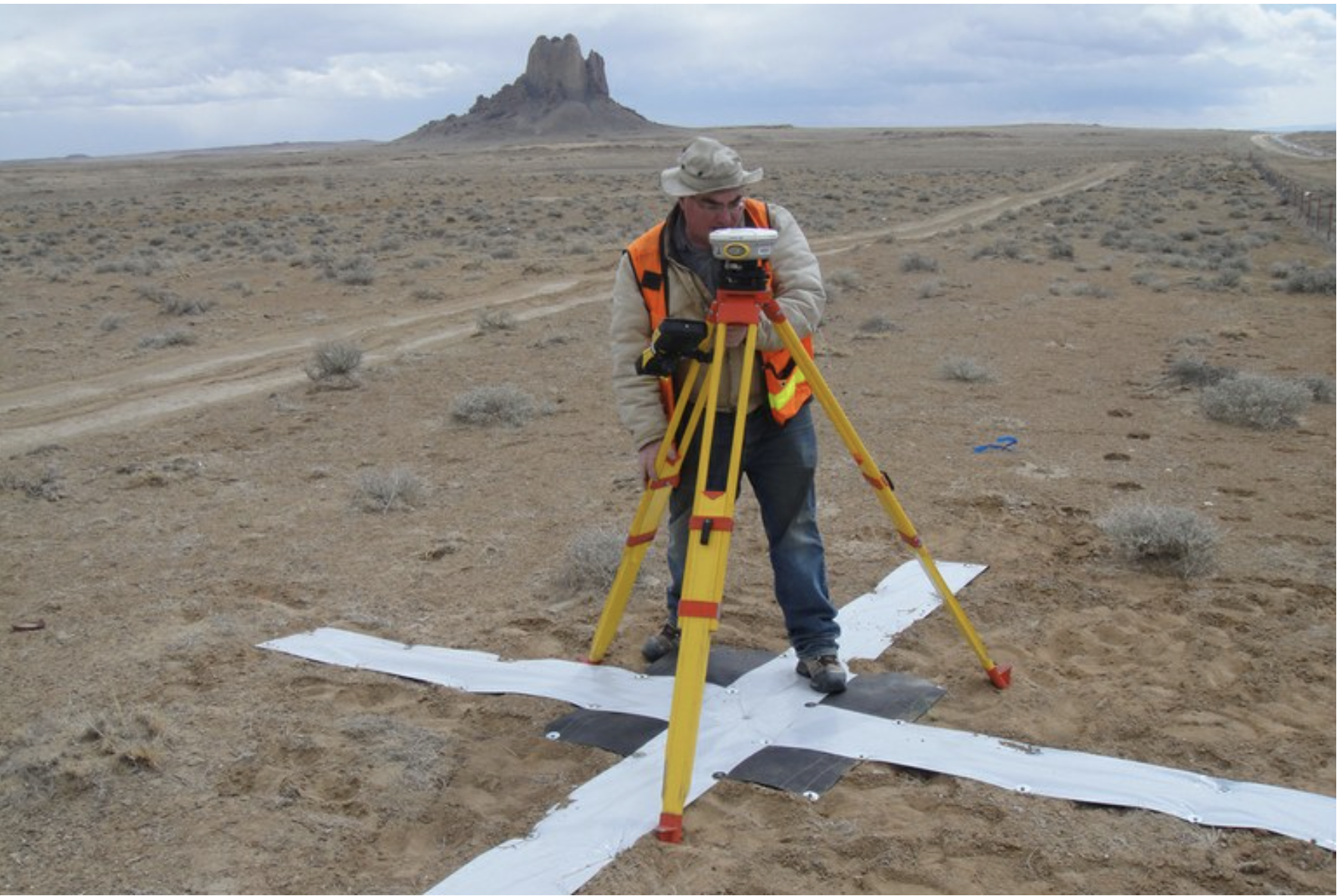
Survey work begins in 2018 for the Navajo-Gallup Water Supply Project on the Navajo Nation. Photo credit: U.S. Bureau of Reclamation via The High Country News
Click the link to read the article on The Deseret News website (Amy Joi O’Donoghue). Here’s an excerpt:
A historic agreement sets aside what was destined to be a protracted legal battle between the Navajo Nation and the state of Utah over rights to water in the Colorado River. With that agreement comes nearly $220 million in funding for the Navajo to provide drinking water to 40% of the tribe in Utah that lacks access to clean, running water. The settlement will be at the center of a ceremonial signing Friday in southern Utah’s Monument Valley featuring Interior Secretary Deb Haaland, Utah Gov. Spencer Cox, the president of the Navajo Nation, Jonathan Nez, Lt. Gov. Deidre Henderson, and Sen. Mitt Romney, R-Utah, who negotiated the funding as part of the Infrastructure and Investment Jobs Act…
What the act does: This is the result of decades of negotiation, recognizing and protecting reserved water rights of the Navajo Nation and the investment of water delivery infrastructure. Specifically it:
Recognizes a reserved water right of 81,500 acre-feet of water for current and future use by the state of Utah.
Facilitates payment by the federal government to the Navajo Nation of over $210 million.
The state of Utah will contribute $8 million toward drinking water infrastructure on the Navajo Nation.
Click the link to read the article on the Las Vegas Sun website (Jessica Hill). Here’s an excerpt:
Dead pool is when the water level would get so low in a reservoir that a dam would no longer be able to produce hydropower or deliver water downstream. It’s been a subject of concern for Lake Powell and Lake Mead, which are on the Colorado River and deliver water to more than 36 million people in seven states as well as Mexico. Lake Mead would reach dead pool if the water level dropped to 895 feet, said Patti Aaron, public affairs officer for the U.S. Bureau of Reclamation’s Lower Colorado Basin Region. As of Wednesday, the level of Lake Mead is 1,049.65 feet, she said.
“We’re not in danger of hitting dead pool,” Aaron said. “It’s not an imminent problem. It’s not something that’s going to happen tomorrow, and it’s something we don’t think is going to happen at all. We would take every action to not have that happen.”
[…]
Aaron said there were two ways to help Lake Mead: One is better hydrology and more snow melt from the mountains running off into the Colorado, but that’s not in anyone’s control. The second way is through conservation by the Lower Basin states — Nevada, Arizona and California, Aaron said, “leaving water instead of taking it.”
The Bureau of Reclamation is working with its partners in funding different pilot projects and studies to conserve water, she said. Projects include lining canals so they’re not losing water due to seepage, and desalination techniques.
“There’s a finite amount of water,” Aaron said, “so we have to look at things like desalination and augmentation.”
Potential Water Delivery Routes. Since this water will be exported from the San Luis Valley, the water will be fully reusable. In addition to being a renewable water supply, this is an important component of the RWR water supply and delivery plan. Reuse allows first-use water to be used to extinction, which means that this water, after first use, can be reused multiple times. Graphic credit: Renewable Water Resources
THE Renewable Water Resources proposal runs counter to the Colorado Water Plan, would likely trigger a federal review under the Wirth Amendment for the harm it could do to the Great Sand Dunes National Park and Baca National Wildlife Refuge, and doesn’t have a developed augmentation plan to meet the required one-for-one replacement within the same Response Area to get the plan through state water court.
Those are some of the findings Attorney Steve Leonhardt laid out in confidential memorandums released Tuesday by Douglas County. The problems Leonhardt sees with the proposal convinced Commissioner Abe Laydon to not support RWR’s request for investment by using federal American Rescue Plan Act money.
However, Laydon and Commissioner George Teal remained open to Renewable Water Resources coming back to them if they can solve the concerns spelled out by Leonhardt, who Douglas County hired on contract to review the RWR plan. Commissioner Lora Thomas, who’s been opposed to RWR, said she did not want Douglas County to spend any more of its time and tax dollars on the RWR plan.
“This is good news for the San Luis Valley and it speaks to the hundreds and perhaps thousands of people who spoke out against this unviable proposal,” state Sen. Cleave Simpson, general manager of the Rio Grande Water Conservation District, said in a released statement.
The problems detailed by Leonhardt are many, particularly as the water exportation proposal relates to the required augmentation plan and the need for Renewable Water Resources to solve that problem by changing existing state rules that govern groundwater pumping in the Valley.
RWR told Douglas County it’s developing a “legislative strategy” to address the requirement.
“In the San Luis Valley, an augmentation plan for wells must not only prevent injury to water rights on the stream system, but must also maintain the sustainability of both the Confined Aquifer and the Unconfined Aquifer,” Leonhardt said in a bulleted memorandum.
“This requires, at a minimum, providing one-for-one replacement for all water pumped, either by retiring historical well pumping or by recharging the aquifer.”
The attorney said not only does the RWR proposal lack a developed augmentation plan but that it cannot meet the state rule that requires “one-for-one replacement within the same ResponseArea.”
“RWR cannot meet this requirement, even if it were to acquire and retire all wells within its Response Area. Therefore, RWR’s plan cannot succeed without an amendment to this rule. RWR is developing a legislative strategy to address this issue.”
Leonhardt’s memo concluded that “the two reasonable options would be to (1) reject the proposal; or (2) continue discussions with RWR (and perhaps other interested parties in Douglas County and/or the San Luis Valley) to see if agreement can be reached on an acceptable proposal.”
Laydon and Teal chose option 2. Thomas wanted Douglas County to walk away altogether.
“Douglas County welcomes ongoing discussions with RWR, should they be able to provide new information or otherwise overcome these hurdles,” said a statement released by Douglas County.
Simpson, during a recent taping of The Valley Pod, told Alamosa Citizen that changing the rules and regulations governing groundwater pumping in the Valley would be a difficult challenge.
“To change the rules and regs, they’d have to go to court as well,” Simpson said. “They would be seeking authorization to change the rules that we all live by. Those are confined aquifer new-use rules and rules and regulations for groundwater withdrawals that everybody else here lives with.
“I’ve highlighted this from the very beginning, that’s a pretty tough hill for them to climb. The money behind this though, I suspect if Douglas County wants to participate in this we’ll see them in court.”
A century ago, English mathematician Lewis Fry Richardson proposed a startling idea for that time: constructing a systematic process based on math for predicting the weather. In his 1922 book, “Weather Prediction By Numerical Process,” Richardson tried to write an equation that he could use to solve the dynamics of the atmosphere based on hand calculations.
It didn’t work because not enough was known about the science of the atmosphere at that time. “Perhaps some day in the dim future it will be possible to advance the computations faster than the weather advances and at a cost less than the saving to mankind due to the information gained. But that is a dream,” Richardson concluded.
For example, a forecast of heavy rainfall two days in advance is now as good as a same-day forecast was in the mid-1990s. Errors in the predicted tracks of hurricanes have been cut in half in the last 30 years.
There still are major challenges. Thunderstorms that produce tornadoes, large hail or heavy rain remain difficult to predict. And then there’s chaos, often described as the “butterfly effect” – the fact that small changes in complex processes make weather less predictable. Chaos limits our ability to make precise forecasts beyond about 10 days.
As in many other scientific fields, the proliferation of tools like artificial intelligence and machine learning holds great promise for weather prediction. We have seen some of what’s possible in our research on applying machine learning to forecasts of high-impact weather. But we also believe that while these tools open up new possibilities for better forecasts, many parts of the job are handled more skillfully by experienced people.
Australian meteorologist Dean Narramore explains why it’s hard to forecast large thunderstorms.
Predictions based on storm history
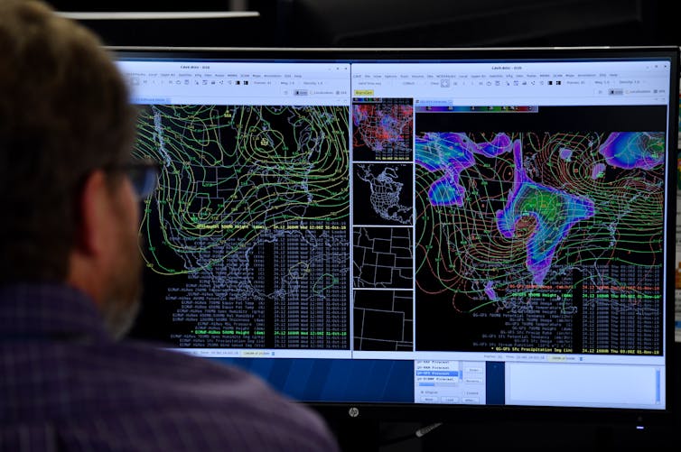
Today, weather forecasters’ primary tools are numerical weather prediction models. These models use observations of the current state of the atmosphere from sources such as weather stations, weather balloons and satellites, and solve equations that govern the motion of air.
These models are outstanding at predicting most weather systems, but the smaller a weather event is, the more difficult it is to predict. As an example, think of a thunderstorm that dumps heavy rain on one side of town and nothing on the other side. Furthermore, experienced forecasters are remarkably good at synthesizing the huge amounts of weather information they have to consider each day, but their memories and bandwidth are not infinite.
Artificial intelligence and machine learning can help with some of these challenges. Forecasters are using these tools in several ways now, including making predictions of high-impact weather that the models can’t provide.
In a project that started in 2017 and was reported in a 2021 paper, we focused on heavy rainfall. Of course, part of the problem is defining “heavy”: Two inches of rain in New Orleans may mean something very different than in Phoenix. We accounted for this by using observations of unusually large rain accumulations for each location across the country, along with a history of forecasts from a numerical weather prediction model.
We plugged that information into a machine learning method known as “random forests,” which uses many decision trees to split a mass of data and predict the likelihood of different outcomes. The result is a tool that forecasts the probability that rains heavy enough to generate flash flooding will occur.
We have since applied similar methods to forecasting of tornadoes, large hail and severe thunderstorm winds. Otherresearchgroups are developing similar tools. National Weather Service forecasters are using some of these tools to better assess the likelihood of hazardous weather on a given day.
An excessive rainfall forecast from the Colorado State University-Machine Learning Probabilities system for the extreme rainfall associated with the remnants of Hurricane Ida in the mid-Atlantic states in September 2021. The left panel shows the forecast probability of excessive rainfall, available on the morning of Aug. 31, more than 24 hours ahead of the event. The right panel shows the resulting observations of excessive rainfall. The machine learning program correctly highlighted the corridor where widespread heavy rain and flooding would occur. Russ Schumacher and Aaron Hill, CC BY-ND
Researchers also are embedding machine learning within numerical weather prediction models to speed up tasks that can be intensive to compute, such as predicting how water vapor gets converted to rain, snow or hail.
It’s possible that machine learning models could eventually replace traditional numerical weather prediction models altogether. Instead of solving a set of complex physical equations as the models do, these systems instead would process thousands of past weather maps to learn how weather systems tend to behave. Then, using current weather data, they would make weather predictions based on what they’ve learned from the past.
Some studies have shown that machine learning-based forecast systems can predict general weather patterns as well as numerical weather prediction models while using only a fraction of the computing power the models require. These new tools don’t yet forecast the details of local weather that people care about, but with many researchers carefully testing them and inventing new methods, there is promise for the future.
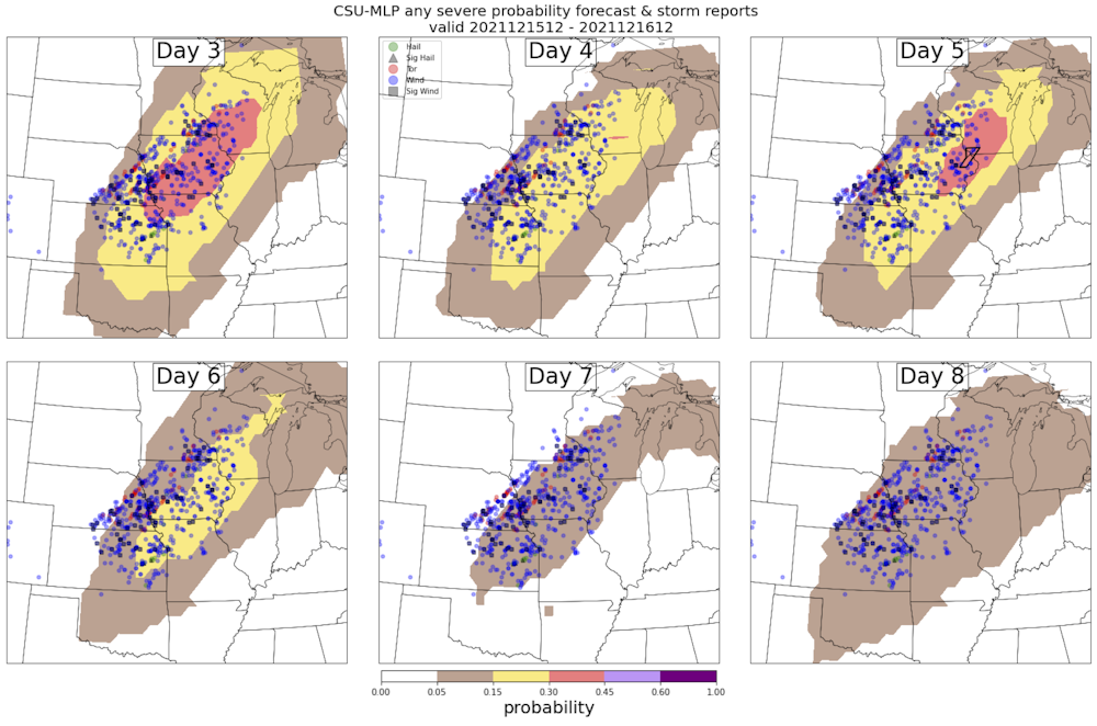
A forecast from the Colorado State University-Machine Learning Probabilities system for the severe weather outbreak on Dec. 15, 2021, in the U.S. Midwest. The panels illustrate the progression of the forecast from eight days in advance (lower right) to three days in advance (upper left), along with reports of severe weather (tornadoes in red, hail in green, damaging wind in blue). Russ Schumacher and Aaron Hill, CC BY-ND
The role of human expertise
There are also reasons for caution. Unlike numerical weather prediction models, forecast systems that use machine learning are not constrained by the physical laws that govern the atmosphere. So it’s possible that they could produce unrealistic results – for example, forecasting temperature extremes beyond the bounds of nature. And it is unclear how they will perform during highly unusual or unprecedented weather phenomena.
And relying on AI tools can raise ethical concerns. For instance, locations with relatively few weather observations with which to train a machine learning system may not benefit from forecast improvements that are seen in other areas.
Another central question is how best to incorporate these new advances into forecasting. Finding the right balance between automated tools and the knowledge of expert human forecasters has long been a challenge in meteorology. Rapid technological advances will only make it more complicated.
Ideally, AI and machine learning will allow human forecasters to do their jobs more efficiently, spending less time on generating routine forecasts and more on communicating forecasts’ implications and impacts to the public – or, for private forecasters, to their clients. We believe that carefulcollaboration between scientists, forecasters and forecast users is the best way to achieve these goals and build trust in machine-generated weather forecasts.
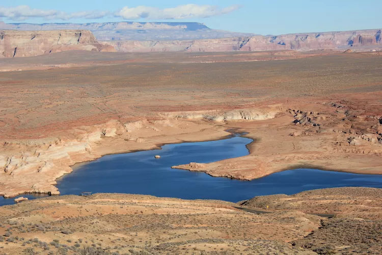
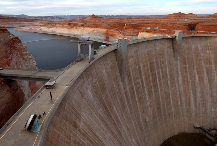
Nook on Lake Powell. Photo credit: Allen Best/Big Pivots
Click the link to read the article on the Big Pivots website (Allen Best):
So I’m off to Glen Canyon, to prowl in the innards of that concrete beast, which looks ever more like the hydraulic equivalent of a mastodon since the waters of Lake Powell keep dipping, dipping, dipping – now sitting at 3,527.7 feet above elevation.
Powell is a tad over 25% full.
My mission has to do with the loss of hydroelectric generation. I began thinking about this six or seven years ago, and now it seems we’re on the cusp, although as many have lately noted, the hydro generation has already dropped off significantly. Powell is 37 feet above that minimum power pool level. The Bureau of Reclamation earlier in May announced it will release less water to the lower basin states from Powell, to keep water levels up. It’s getting harder and harder to make the hydraulic empire of the American Southwest work as designed.
Now comes what one Colorado River expert describes as a “huge” declaration. Bruce Babbitt, the governor of Arizona from 1978 to 1987 and secretary of Interior during the Clinton presidency, says it’s time for a more substantial rethinking of the Colorado River Compact, single most important agreement governing the Colorado River.
“While I once thought that these aridification scenarios were kind of abstract and way out in the future, I don’t think that anymore,” Babbitt said in an interview with the Los Angeles Times’ Ian James.
“It’s absolutely urgent that we start thinking now, while there’s time, about how we adjust the compact, the regulations, the necessary reductions, in the most careful way so that we limit the damage, which can really be extreme.”
Climate change models had predicted a warming Southwest. The resulting aridification – as opposed to the more ephemeral drought – has been well documented in the 21st century. This winter provides yet another example of at least modestly good snows followed by a runoff substantially below average. As the dry winds blow and the temperatures warm, the moisture gets sucked up, instead of going downstream.
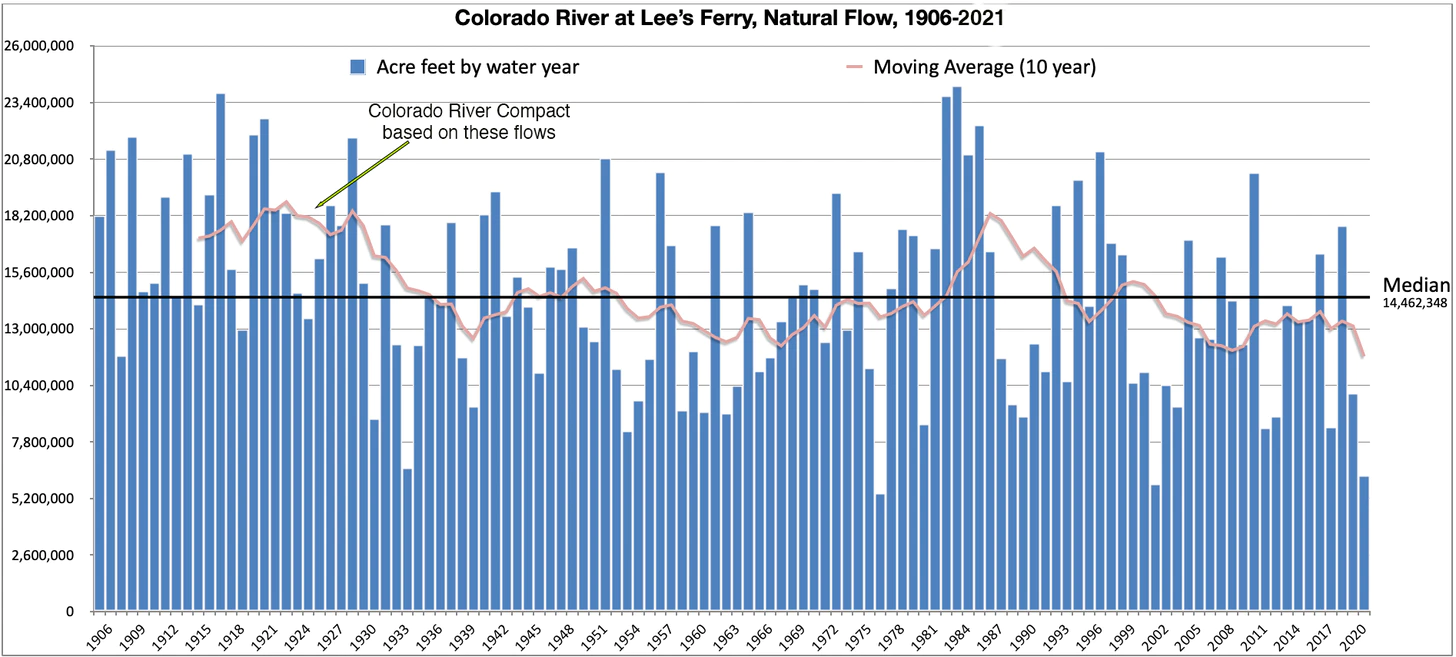
I mused about this after a Thanksgiving trip to Santa Fe that included a side trip to the Bishop’s Lodge, site of the 1922 crafting of the Colorado River Compact among the seven basin states. Their assumptions were badly misaligned with hydrologic reality, as became increasingly evident in the 20th century.
Still, the conventional wisdom has been that the compact was difficult to achieve during a time of assumed plenty. Why would anybody want to open it up now? There was just too much risk, too much potential for inviting paralyzing acrimony.
Instead, in a new era of cooperative, water managers in the 21st century has created end-around agreements. The most recent iteration of end-around is the 2019 Drought Contingency Plan. It is being followed by another such plan, to be ready by 2026, requiring harder decisions, more compromises, greater recognition of the water supplies that are little more than half of that were assumed 100 years ago.
More will be needed, said Babbitt.
“We can no longer just kind of muddle along. We really have to think big, because we’re going to have to create a new regulatory framework. And it doesn’t mean that we have to start over from scratch,” Babbitt told the LA Times.
“The Colorado River Compact has worked for 100 years. But there is now a future scenario in which the fixed delivery obligation — from the Upper Basin states at Lees Ferry to California, Arizona and Nevada — simply doesn’t work.”
In this, Babbitt alludes to a clause in the compact, Article III(d), which requires Colorado and other upper-basin states to not cause the river to flow less than 75 million acre-feet over the course of every 10 years. But what if the river is only producing 9 million acre-feet?
Does that mean Denver can’t divert water? Or the Colorado Big-Thompson? Even in Fort Morgan, people drink Colorado River water.
We’re in for a rude reckoning still in Colorado, regardless of how this shakes out on the Colorado River Compact. New landscaping I see in Arvada, where 72% of water comes from the Colorado River Basin, fails to recognize this future. Hurrah for the mayor of Aurora, Mike Coffman, who said it’s time to ban new turf golf courses – just as Las Vegas has decided.
But the language of the compact might be interpreted to say that the Colorado, Utah, Wyoming and New Mexico will absorb nearly all the reality of climate change. Babbitt is saying no, it shouldn’t be.
This interview reverses what Babbitt said in an op-ed published in the Arizona Republic in July 2021. “We have not reached that point,” he said of reconsidering the compact.
Babbitt may have been responding to a paper written by Eric Kuhn, the former general manager of the Colorado River Water Conservation District, and several others, including Jack Fleck, a New Mexico-based writer and co-author with Kuhn of a book called “Science be Dammed.”
“Our basic argument is that climate change has undermined the basic purpose of the compact – an ‘equitable division’ of the use of the waters of the river between the two (upper and lower) basins,” Kuhn explained to me by e-mail.
“I’m surprised (and pleased) how quickly a revered figure like Governor/Secretary Babbitt has come to the conclusion as well. My optimistic view remains that we’re looking at a collective interpretation of the compact that if climate change, not Upper Basin depletions, is the reason that the upper basins can’t meet the 75 million acre-feet every 10 years, there is no compact violation. The chance of a formal amendment to the compact ratified by seven state legislatures and Congress is still very remote.”
I’ll be closely watching where this conversation goes. It would be a huge pivot for the Southwest.
Eugene Clyde LaRue measuring the flow in Nankoweap Creek, 1923. Photo credit: USGS via Environment360
Construction workers build a single family home in Castle Rock. The community needs new surface water supplies to reduce its reliance on non-renewable groundwater. Credit: Jerd Smith
Douglas County officials said Tuesday they would not use their COVID-relief funding to help finance a controversial $400 million-plus proposal to export farm water from the San Luis Valley to their fast-growing, water-short region.
In a statement the commissioners said the federal rules would not allow the funds to be spent to help finance early work on the proposed project, and that it faced too many legal hurdles to justify the time and money the county would need to devote to it.
The county made public Tuesday two extensive legal memos, based on its outside attorneys’ review of engineering, and legal and regulatory requirements the project would have to adhere to in order to proceed. The memos formed the basis for the county’s rejection of the funding request.
“The Board of Douglas County Commissioners has made the decision, based on objective legal recommendations from outside counsel, that American Rescue Plan Act (ARPA) funds are inapplicable to the RWR proposal and that RWR has significant additional hurdles to overcome in order to demonstrate not only a ‘do no harm’ approach, but also a ‘win-win’ for Douglas County and the San Luis Valley,” the board said.
The proposal comes from Renewable Water Resources (RWR), a well-connected Denver development firm that includes former Colorado Gov. Bill Owens.
Among other things, the memos said that RWR’s claim that there was enough water in the valley’s aquifers to support the export plan, was incorrect, based on hydrologic models presented over the course of several public work sessions.
The county’s attorneys also said the proposal did not comply with the Colorado Water Plan, which outlines how the state will meet future water needs. That lack of compliance means that Douglas County would likely not win any potential state funding for the export proposal.
County Commissioner Lora Thomas came out against the idea early, with Commissioner Abe Layden joining her this week in voting against the proposal. Commissioner George Teal voted for the proposal.
“I am ecstatic that I got a second vote to stop it,” Thomas said. “The hurdles are too steep for us to get over. I don’t see a future for it.”
RWR declined an interview request regarding the decision, but in a statement it said it planned to continue working with the county to see if the legal concerns raised could be resolved.
“Our team is eager to address the county’s remaining questions as raised in the legal analysis. We are confident in our ability to mitigate any areas of concern,” it said.
Opposition to the proposal sprang up quickly last December after RWR submitted its $10 million funding request to the commissioners.
Critics, including the Rio Grande Water Conservation District in Alamosa, argued that no water should be taken from the San Luis Valley because it is already facing major water shortages due to the ongoing drought and over-pumping of its aquifers by growers. The valley faces a looming well-shutdown if it can’t reduce its water use enough to bring its fragile water system back into balance.
RWR said its plan to shut down agricultural wells could help the valley, but many disagreed.
State Sen. Cleave Simpson, who also manages the Rio Grande Water Conservation District, said in a statement that he was pleased with Douglas County’s decision. “This is good news for the San Luis Valley and it speaks to the hundreds and perhaps thousands of people who spoke out against this unviable proposal.”
Environmental groups also came out in opposition, as have numerous elected leaders including Democrats Gov. Jared Polis, Attorney General Phil Weiser, U.S. Sens. John Hickenlooper and Michael Bennet, as well as Republican U.S. Rep. Lauren Boebert, who represents the valley.
Douglas County does not deliver water to its residents, but relies on more than a dozen individual communities and water districts to provide that service. And they are all facing the need to develop new water supplies.
But two of the largest providers, Parker Water & Sanitation District and Castle Rock Water, have said they would not support the RWR proposal because they had already spent millions of dollars developing new, more sustainable, politically acceptable projects. Those projects include a South Platte River pipeline that is being developed in partnership with farmers in the northeastern corner of the state.
What comes next for RWR’s proposal isn’t clear yet. RWR spokeswoman Monica McCafferty said the firm’s attorneys were still reviewing the legal memos the county released Tuesday.
RWR has said previously that it might ask lawmakers to change state water laws to remove some of the legal barriers to its proposal.
Jerd Smith is editor of Fresh Water News. She can be reached at 720-398-6474, via email at jerd@wateredco.org or @jerd_smith.
A powerful sprinkler capable of pumping more than 2,500 gallons of water per minute irrigates a farm field in the San Luis Valley June 6, 2019. Credit: Jerd Smith via Water Education Colorado
Click the link to read “Douglas County commissioners reject using federal money for water project, will continue talks” on the Colorado Politics website (Marianne Goodland). Here’s an excerpt:
At the heart of Tuesday’s decision: Two memos from water attorneys regarding the project that has been kept under wraps since mid-March. Commissioners authorized their release to the public Tuesday.
The first memo, dated March 23, is from attorneys Stephen Leonhardt and April Hendricks of the firm Burns, Figa & Will. Its executive summary said there is “no unappropriated water” available in the confined aquifer, the source for the RWR project. In addition, RWR has not come up with an augmentation plan in sufficient detail to demonstrate that its plan will meet the requirements of the state water rules and avoid injury to other water rights, the memo added. The RWR project “is not consistent” with the state’s water plan, so no state dollars would likely be available for it; and that Douglas County will face numerous hurdles to obtain federal, state and county permits for the project after a decree from state water court is entered. “RWR does not intend to obtain permits before going to Water Court, and RWR’s current proposal calls for Douglas County to bear all responsibility for obtaining the required permits for this project. Obtaining the required federal, state, and county permits likely will take several years, at a substantial financial cost to Douglas County, with a risk that one or more permits will be denied.”
The May 2 memo notes that Leonhardt and Douglas County attorney Lance Ingalls attended a meeting with RWR’s attorneys at Brownstein Hyatt Farber Shreck as well as RWR principal John Kim on April 1…
The May 2 memo is divided into several sections, including water availability, sale of water rights, water supply impacts, sustainability of the closed aquifer, and dry-up of irrigated agricultural lands. Among the findings:
Questions on whether ARPA money could be used for the project
Recognition that an RWR-supported community fund would not mitigate economic losses from the dry-up of irrigated lands and impacts on related businesses
Opposition from the Rio Grande Water Conservation District, which is managed by state Sen. Cleave Simpson, R-Alamosa, a major opponent of the projects
Difficulty in rehabilitating the land once the water is removed
The closed aquifer cannot sustain any new pumping, and that a buyer of water rights could only use those rights for their originally decreed purposes, meaning RWR would have to go to water court to change those uses from agricultural to municipal, which could mean a lengthy court battle
Both Laydon and Teal directed the commission’s staff to continue working on a deal with RWR that does not use ARPA money.
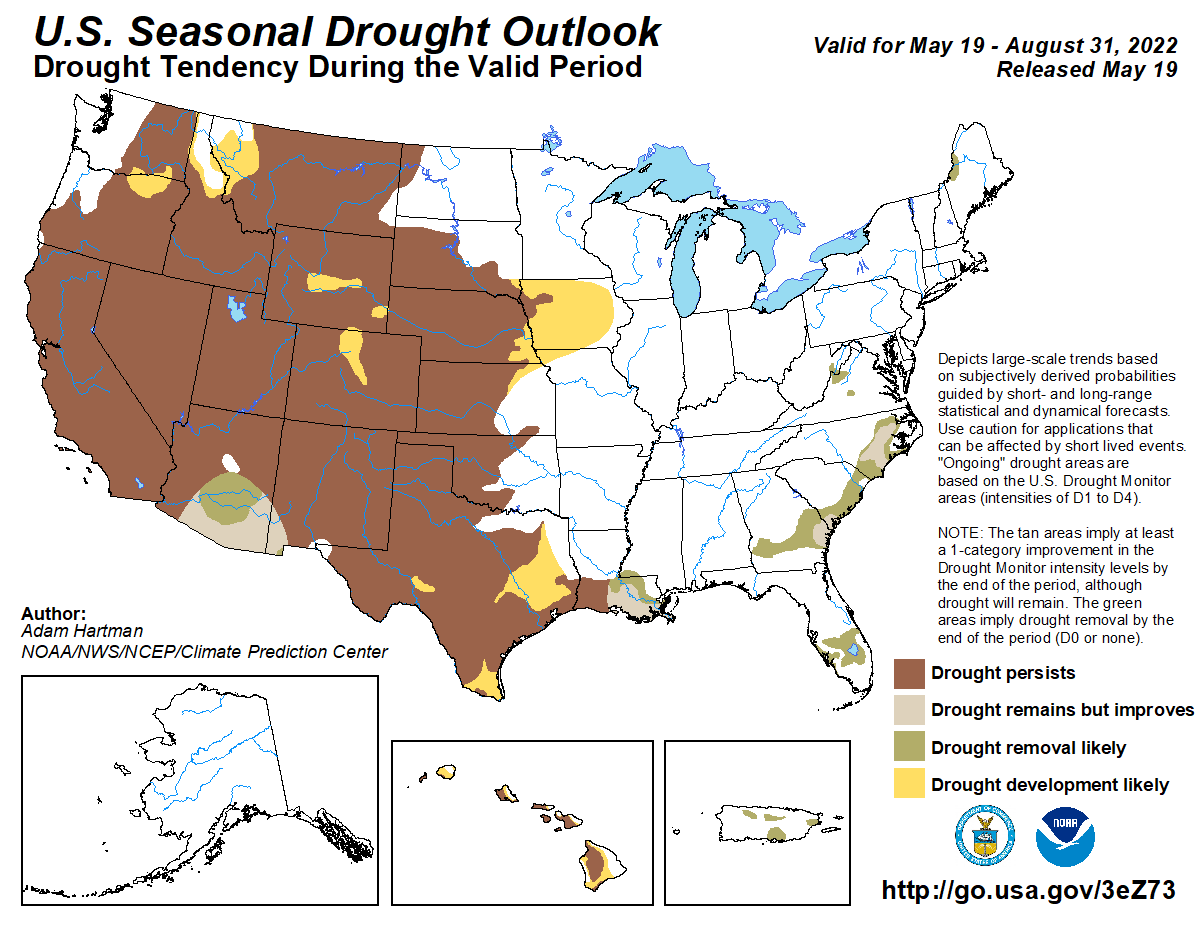
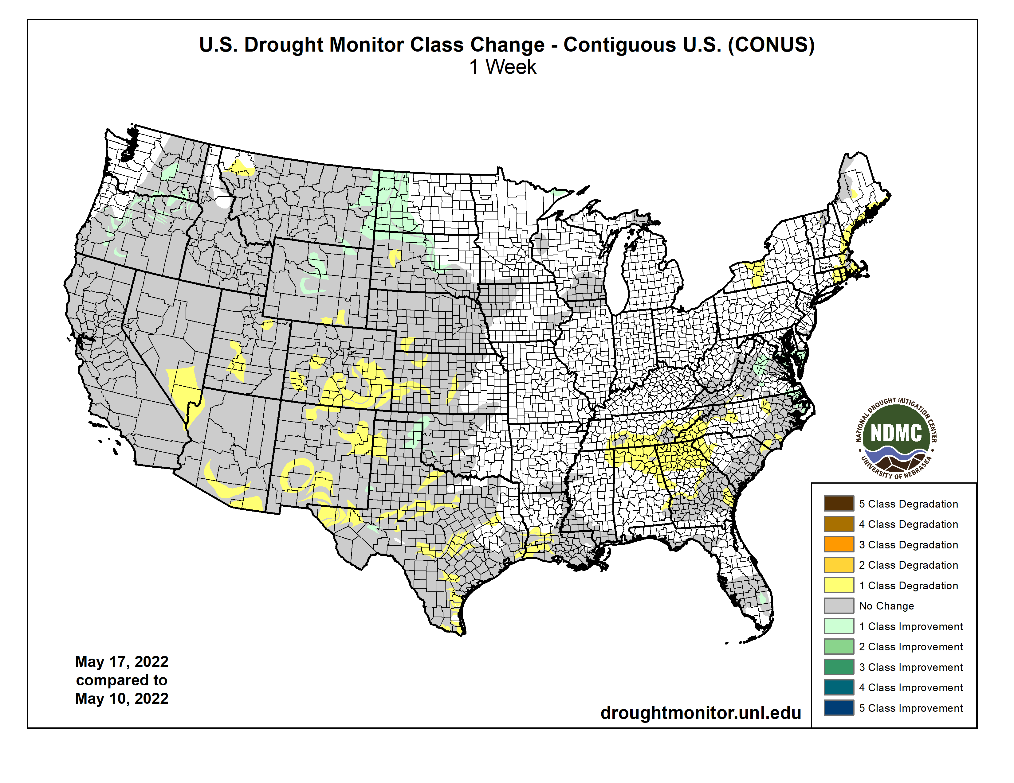
A strong upper-level trough moved across the contiguous U.S. (CONUS) during this U.S. Drought Monitor (USDM) week (May 18-24). Surface low pressure systems and cold fronts were associated with this complex trough. They tapped Gulf of Mexico moisture to spread above-normal precipitation across parts of the Plains, Midwest, Southeast, and Mid-Atlantic Coast, and locally heavy snow across parts of Colorado. One of the fronts moved very slowly across the southern Plains near the end of the week, dumping locally heavy rain on parts of Oklahoma and Texas. Precipitation also fell across parts of the Pacific Northwest, North Dakota, and western Great Lakes. Most of the West was drier than normal, with much of the area from Oregon to California and southern Idaho to New Mexico receiving little to no precipitation. Weekly temperatures averaged below normal behind the fronts from the Pacific Northwest to Great Lakes and from the northern Rockies to Mid-Mississippi Valley. Temperatures averaged warmer than normal across the eastern third of the CONUS and from California to Texas. The continued lack of precipitation in the dry areas further dried soils, lowered stream levels, and stressed crops and other vegetation, while the warmer-than-normal temperatures increased evapotranspiration that added to the stress caused by lack of precipitation. But widespread heavy rain fell across several drought areas, contracting drought and abnormal dryness, especially in the central to southern Plains, Lower Mississippi Valley, Southeast, and Mid-Atlantic states. Drought and abnormal dryness also shrank in the Pacific Northwest where drought indicators showed improving conditions. Drought or abnormal dryness expanded or intensified where it continued dry, especially in southern parts of the West, in the Ohio and Tennessee Valleys, and parts of southern New England…
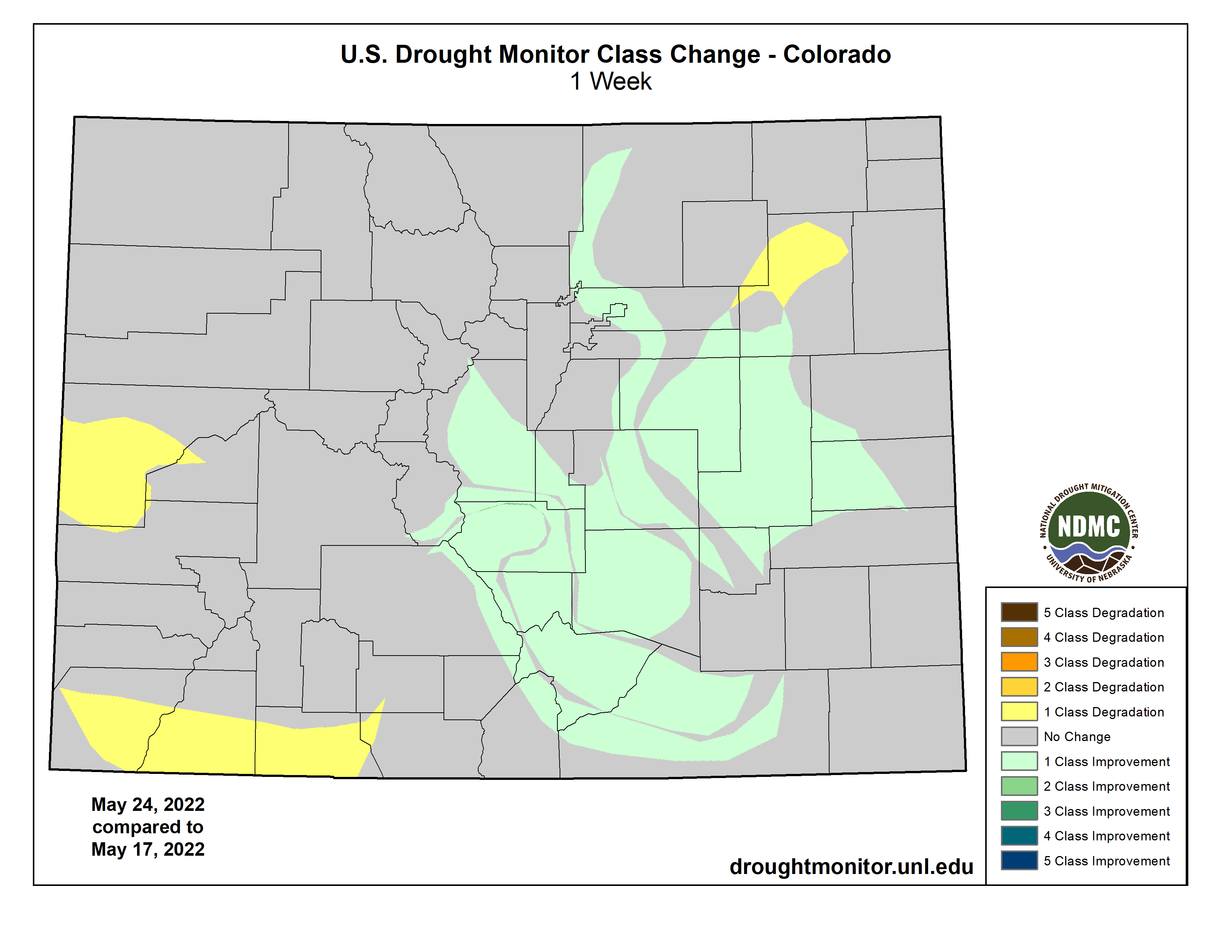
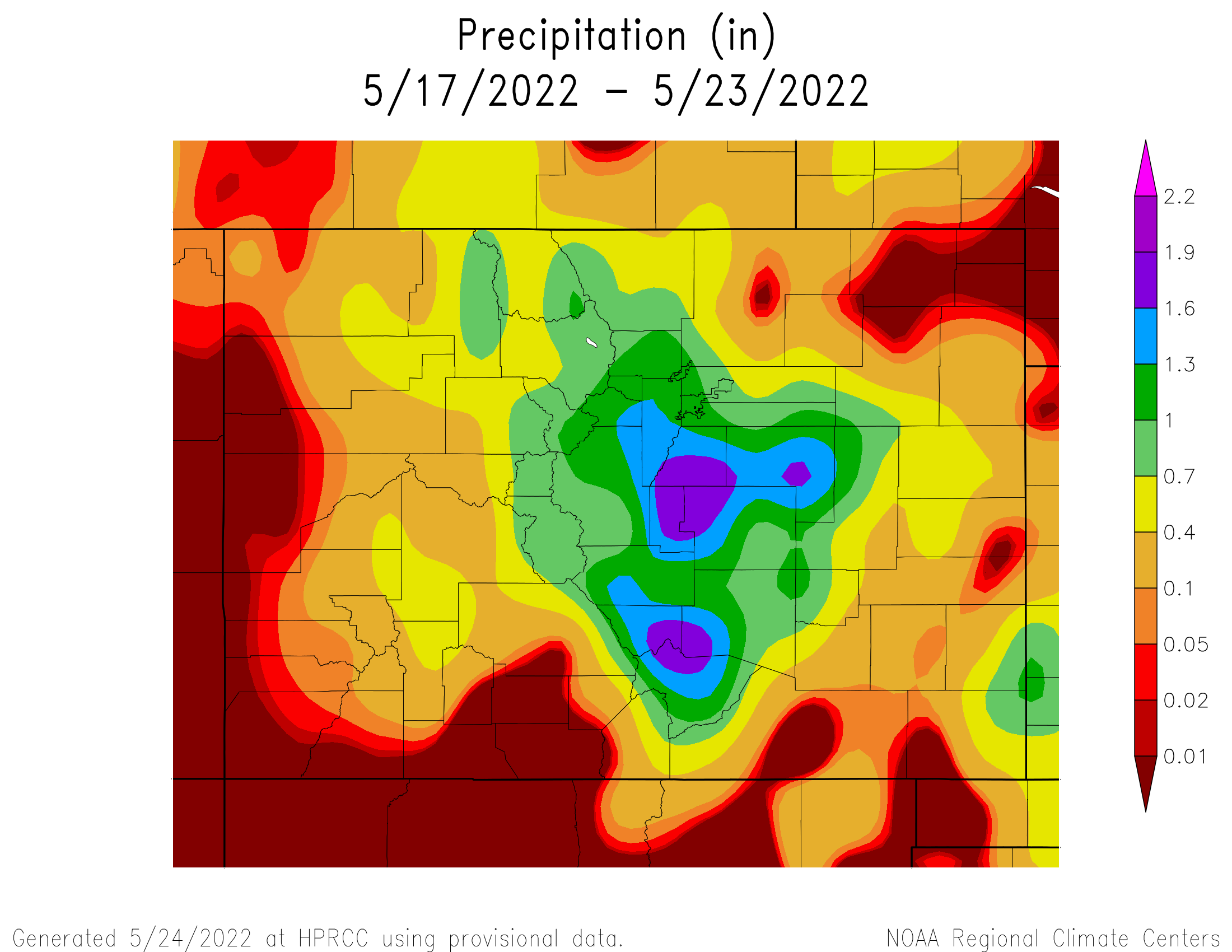
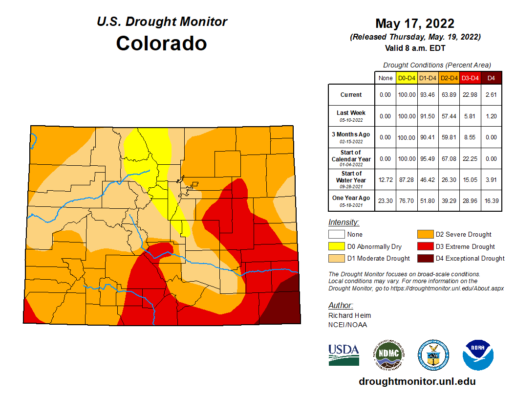
Two inches or more of precipitation fell across southern and eastern parts of Kansas, central Colorado, and northeast Nebraska, while half an inch or more was widespread across North Dakota. Parts of Nebraska, northeast Colorado, Wyoming, South Dakota, and eastern Montana received less than half an inch of precipitation. In Colorado, moderate to extreme drought contracted where it was wet, while severe and extreme drought expanded where it was dry. Abnormal dryness and moderate to extreme drought shrank in parts of Kansas. The rain ate a hole into severe drought in northeast Nebraska. Abnormal dryness and moderate drought were trimmed in western North Dakota. On the other hand, it was a dry week in western Wyoming with D3 expanding in Teton County…
Colorado Drought Monitor one week change map ending May 24, 2022.
Half of an inch or more of precipitation fell in the Coastal and Cascade ranges of the Pacific Northwest, and northern to central Rockies. But more southerly parts of the West, from southern Oregon to New Mexico, received no precipitation. Abnormal dryness to severe drought were trimmed in Washington, Oregon, Idaho, and Montana. Extreme drought shrank in southwest Montana, while exceptional drought was trimmed in Oregon. Some of the drought contraction was due to drought indicators showing slightly less severe conditions. In the drier areas of the West, D3-D4 expanded in New Mexico, D2-D3 expanded in Arizona, D3 spread in Utah and adjoining parts of Idaho and Wyoming, and D2 expanded in southern California with slight expansion of D4 from adjoining southern Nevada. Arms of exceptional drought were added to the San Joaquin Valley in California where the National Weather Service noted that dry conditions continue throughout the area; snow cover is virtually non-existent below 8,000 feet; peak flow through area rivers and inflow into the reservoirs has already occurred or will occur soon, weeks ahead of normal; and applications for grants for well drilling, purchasing tanks, and bottled water recipients are increasing. In southern California, the Coastal Fire broke out on May 11th in Orange County near Laguna Niguel. Windy conditions spread it rapidly upcanyon where it burned 200 acres, destroyed 20 homes, and damaged 12 others. Near-record dry fuels around the May 11th time frame set the stage for this fire…
A large part of Oklahoma and parts of Texas and Louisiana were inundated with several inches of rain, over 6 inches in places. Zapata County in southern Texas received about half a year of normal rainfall this week. Heavy rain in central and northern Oklahoma, and in the Texas panhandle, southern Texas, and southeast Texas, resulted in the contraction of abnormal dryness and moderate to exceptional drought. Abnormal dryness contracted in Arkansas, D0 and D1 contracted in Mississippi, and D0-D3 shrank in Louisiana. Other parts of the South region were dry. D2-D4 expanded in parts of central to northeast Texas, D0 expanded in Mississippi and Tennessee, and a spot of moderate drought was added in eastern Tennessee…
Looking Ahead
A strong upper-level low pressure system slowly moved across the Plains during May 24 and 25, spreading heavy rain over the southern and central Plains to Lower and Mid-Mississippi Valley. This weather system, with its surface low and fronts, will move slowly eastward during the next several days. Another upper-level low pressure system will move from the Pacific Ocean into the western CONUS by Sunday. In addition to the 1+ inches of rain that has already fallen across the Plains to Mississippi Valley May 24-25, another 1 to 2 inches is expected from the Mississippi Valley to Appalachians and northward to the Great Lakes through May 31. An inch or more of precipitation is forecast for the Pacific Northwest to northern Plains and parts of the Interior Basin in association with the western weather system. Little to no precipitation is expected through May 31 for southern states in the West, and no additional precipitation is forecast for Texas and western portions of the southern High Plains. Warmer-than-normal temperatures are forecast for May 26-31 for the central to southern Plains ahead of the western weather system, while clouds and rain will keep high temperatures near to cooler than normal in the West and East. For May 31-June 4, odds favor above-normal precipitation in the Pacific Northwest, Great Plains, Southeast, and most of Alaska, but below-normal precipitation for the Midwest to Northeast and California to southern Nevada. Warmer-than-normal temperatures are likely for May 31-June 4 across most of Alaska and the eastern half of the CONUS, while odds favor cooler-than-normal temperatures from the Great Basin to northern Plains.
US Drought Monitor one week change map ending May 24, 2022.
Vangelis, the Greek film composer and synthesizer virtuoso whose soaring music for “Chariots of Fire,” the 1981 movie about two British runners in the 1924 Summer Olympics in Paris, won the Academy Award for best original score, died on Tuesday in Paris. He was 79…
A self-taught musician, Vangelis (pronounced vang-GHELL-iss), who was born Evangelos Odysseas Papathanassiou, recorded solo albums and wrote music for television and for films including “Blade Runner” (1982), “Missing” (1982) and “1492: Conquest of Paradise” (1992). But he remains best known for scoring “Chariots of Fire.”
The most familiar part of that score — modern electronic music composed for a period film — was heard during the opening credits: a blend of acoustic piano and synthesizer that provided lush, pulsating accompaniment to the sight of about two dozen young men running in slow motion on a nearly empty beach, mud splattering their white shirts and shorts, pain and exhilaration creasing their faces.
Vangelis’s music became as popular as the film itself, directed by Hugh Hudson, which won four Oscars, including best picture. The opening song, also called “Chariots of Fire,” was released as a single and spent 28 weeks on the Billboard Hot 100 chart, including a week at No. 1. The soundtrack album remained on the Billboard 200 chart for 30 weeks and spent four weeks in the top spot. Vangelis said the score immediately came to him as he watched the film in partly edited form…
He was working at the time in his London studio with a Yamaha CS-80 synthesizer.
“It’s the most important synthesizer in my career and the best analog synthesizer design there has ever been,” he told Prog, an alternative music website, in 2016, adding, “It’s the only synthesizer I could describe as being a real instrument.”
Governor visits Valley to make the announcement; signs Simpson bill that brings $30 million to Rio Grande Basin
EXPECT more truckloads of potatoes grown in the San Luis Valley to be headed south into Mexico in the near future.
Gov. Jared Polis showed up in the Valley on Monday bearing good news. Joined by potato growers and U.S. Department of Agriculture Undersecretary Jenny Lester Moffitt, Polis announced a new agreement that opens up the entire country of Mexico to potato exports from Colorado.
“As you know we are the second biggest potato producing region overall, but we are the best-situated potato region for export to the Mexican market and we are very excited about what the opportunity means,” said Polis.
He said the state and the Colorado Potato Administrative Committee headed by Jim Ehrlich will work next at identifying the specific regions of Mexico to increase Colorado potato exports and identifying buyers in Mexico.
Increasing potato exports to Mexico was one of two stops Polis made in the Valley. He also joined State Sen. Cleave Simpson and a host of local dignitaries to sign two water-related bills into law that were sponsored by Simpson:
HB22-1316, the Colorado Water Conservation Board Construction Fund which pays for items like satellite monitoring system operation and maintenance, weather modification permitting, Colorado floodplain map modernization, among other projects.
Cautious optimism
Working with Mexico to get more potato exports from Colorado was greeted with cautious optimism by Valley farmers. The U.S. and Mexico had worked out a similar arrangement seven years ago, said Ehrlich, only to have Mexico revert back to limited exports 11 days into the agreement.
Ehrlich said there is hope this new agreement will last longer, which Polis said it will since Mexican President Andrés Manuel López Obrador signed off on the agreement and López Obrador will be in office through September 2024.
Ehrlich credited U.S. Secretary of Agriculture Tom Vilsack and U.S. Sen. Michael Bennet for their persistent efforts to get Mexico to open up on agriculture exports. “For years, I’ve worked with Colorado’s potato growers to cut through red tape and restore access to the industry in Mexico,” Bennet said. “I’m pleased to see the first shipments of U.S. fresh potatoes to Mexico in over 25 years. I’ll keep fighting to keep this market open.”
Ehrlich said Vilsack, during his time as ag secretary under President Obama, had been working on getting Mexico to agree to more exports and was able to pick up that work and complete it when President Biden named Vilsack his ag secretary.
“We hope this will be a durable agreement over time,” Ehrlich said.
Last year, Colorado exported more than 122 million pounds of potatoes to Mexico, according to the governor’s office. Colorado exported $1.4 billion of goods to Mexico, including potatoes, making it Colorado’s second largest export destination. With this new announcement the U.S. has begunexporting potatoes beyond the 26-kilometer border zone that previously marked the limit of their export, the governor said.
The Valley exports potatoes by truck into Mexico. The Mexicans are partial to the alpha potato, but Ehrlich and Polis said the new agreement will yield Mexico all types of potatoes grown in the Valley.
“Our growers here are some of the best potato growers in the world,” Ehrlich said. “I anticipate that we will only ship our very best product to Mexico.
“We’re going to expose them to all different kinds, reds, yellows, russets, we anticipate we’ll expose them to everything.”
The competitive Polis, who has chided neighboring New Mexico that the green chile grown in Colorado is superior, took aim at Idaho with the potato announcement.
“We are the second largest (potato-growing state), but Idaho we’re coming for you.”
The UGRWCD presents the 1st Annual UPPER GUNNISON RIVER BASIN WATER ROUNDUP! Join us at the I Bar Ranch Thursday, June 9, 2022 from Noon to 9 PM. Register today at: https://t.co/0khTkr6rjJ or call the District at (970)641-6065. Hope to see you there! pic.twitter.com/gYEB7yB71i
Potential Water Delivery Routes. Since this water will be exported from the San Luis Valley, the water will be fully reusable. In addition to being a renewable water supply, this is an important component of the RWR water supply and delivery plan. Reuse allows first-use water to be used to extinction, which means that this water, after first use, can be reused multiple times. Graphic credit: Renewable Water Resources
The Douglas County commissioners have decided not to use American Rescue Plan Act dollars on a controversial water supply project but may consider it again in the future. Commissioner Abe Laydon, the decisive vote on the issue, announced his vote during a May 24 work session…
Laydon said his decision was because the county’s outside legal counsel concluded that the project was not eligible for ARPA funds and recommended the county not participate…
One issue outlined in the memo is that Renewable Water Resources has not formed an augmentation plan — as would be required by law — showing how they will avoid injury to other water rights through their project. Commissioner Lora Thomas has been against the proposal since it was brought before the county and said she is not in support of continuing any conversations with RWR or paying for outside legal counsel to continue assessing it.
Colorado Wheat Field Days kick-off in two weeks! Be sure to note there have been some changes made from the original schedule. pic.twitter.com/Y8GteWAQKz
Gov. Jared Polis on Monday signed two bills into law that are aimed at conserving a precious and dwindling resource in the state: water. For the bill signings, the governor traveled to the San Luis Valley, an important agricultural region where farmers face mounting challenges from extreme drought driven by climate change.
Republican Sens. Cleave Simpson of Alamosa and Jerry Sonnenberg of Sterling, plus Reps. Dylan Roberts, an Avon Democrat, and Marc Catlin, a Montrose Republican, sponsored the first bill, Senate Bill 22-28. It puts $60 million of federal COVID-19 relief money into a new “groundwater compact compliance and sustainability” fund to help finance projects that reduce groundwater use in the Rio Grande and Republican river basins.
GET THE MORNING HEADLINES DELIVERED TO YOUR INBOX
Such projects might include efforts to “buy and retire” wells used for irrigation as well as portions of irrigated farmland, with the goal of restoring water to underground aquifers and helping the communities meet deadlines to reduce their water use. The Colorado Water Conservation Board can allocate money from the groundwater fund based on recommendations from the boards of directors for the Rio Grande Water Conservation District and the Republican River Water Conservation District.
“The timing of the availability of federal dollars and the growing sense of urgency in both basins created a unique opportunity that will serve both of these communities well,” Simpson told the Alamosa Citizen in April.
The other bill Polis signed, House Bill 22-1316, provides millions of dollars for construction projects approved by the Colorado Water Conservation Board. The bill’s legislative sponsors included Reps. Karen McCormick, D-Longmont, and Catlin, along with Sens. Kerry Donovan, D-Vail, and Simpson. Among the local and regional projects funded are:
$3.8 million for the Platte River Recovery Implementation Program. By increasing water flows through the central Platte River habitat area — which stretches across northern Colorado, Wyoming and Nebraska — the project is aimed at improving conditions for the interior least tern, pallid sturgeon, piping plover and whooping crane.
$2 million to support the state’s efforts to comply with the Republican River compact, which was first negotiated between Colorado, Kansas and Nebraska in the early 1940s. The compact governs the three states’ use of the water resources in the Republican River basin, which begins on the plains of eastern Colorado and flows through northwest Kansas and eastern Nebraska.
$500,000 for the Arkansas River Decision Support System. The Arkansas River DSS project involves collecting data on characteristics like climate and groundwater in the Arkansas River basin, which covers the southeast quadrant of the state, and analyzing the data to help inform future decisions about water use.
Polis, a Democrat, signed both bills into law at the Rio Grande Water Conservation District offices in Alamosa. According to a statement from Polis’ office, the governor then joined state and national officials in the nearby town of Center to champion a major development for the San Luis Valley’s potato industry.
The U.S. recently began exporting potatoes — including those grown in the Valley — to new regions in Mexico under an agreement reached late last year between the two countries. Previously, potato exports were limited to a 16-mile border zone.
“This agreement, paired with the critical work the Valley is doing to protect and conserve our water, will make a major positive difference for our farmers, meaning more money in the pockets of hardworking Coloradans,” Polis said in a statement. “Colorado is strategically positioned to lead the nation in potato exports to Mexico.”
Colorado sent its first shipment of potatoes to Mexico under the new agreement last week, according to the statement.
SUPPORT NEWS YOU TRUST.
Colorado Newsline is part of States Newsroom, a network of news bureaus supported by grants and a coalition of donors as a 501c(3) public charity. Colorado Newsline maintains editorial independence. Contact Editor Quentin Young for questions: info@coloradonewsline.com. Follow Colorado Newsline on Facebook and Twitter.
Click the link to read the release on the NOAA website:
Greenhouse gas pollution caused by human activities trapped 49% more heat in the atmosphere in 2021 than they did in 1990, according to NOAA scientists.
NOAA’s Annual Greenhouse Gas Index, known as the AGGI, tracks increases in the warming influence of human emissions of heat-trapping gases, including carbon dioxide, methane, nitrous oxide, chlorofluorocarbons, and 16 other chemicals. The AGGI converts the complex scientific computations of how much extra heat these gases capture into a single number that can easily be compared to previous years and tracks the rate of change.
This graph depicts the relative contributions of the major greenhouse gas pollutants to global warming, in watts per square meter along the left axis. The NOAA Annual Greenhouse Gas Index (AGGI) is shown on the right axis. Credit: NOAA Global Monitoring Laboratory
The AGGI is indexed to 1990, the baseline year for the Kyoto Protocol and the year the first IPCC Scientific Assessment of Climate Change was published.
“The AGGI tells us the rate at which we are driving global warming,” said Ariel Stein, the acting director of NOAA’s Global Monitoring Laboratory (GML). “Our measurements show the primary gases responsible for climate change continue rising rapidly, even as the damage caused by climate change becomes more and more clear. The scientific conclusion that humans are responsible for their increase is irrefutable.”
In 2021, the AGGI reached a value of 1.49, which means that human-emitted greenhouse gases trapped 49% more heat in the atmosphere than in 1990. Because it is based primarily on highly accurate measurements of greenhouse gases in air samples collected around the globe, the result contains little uncertainty.
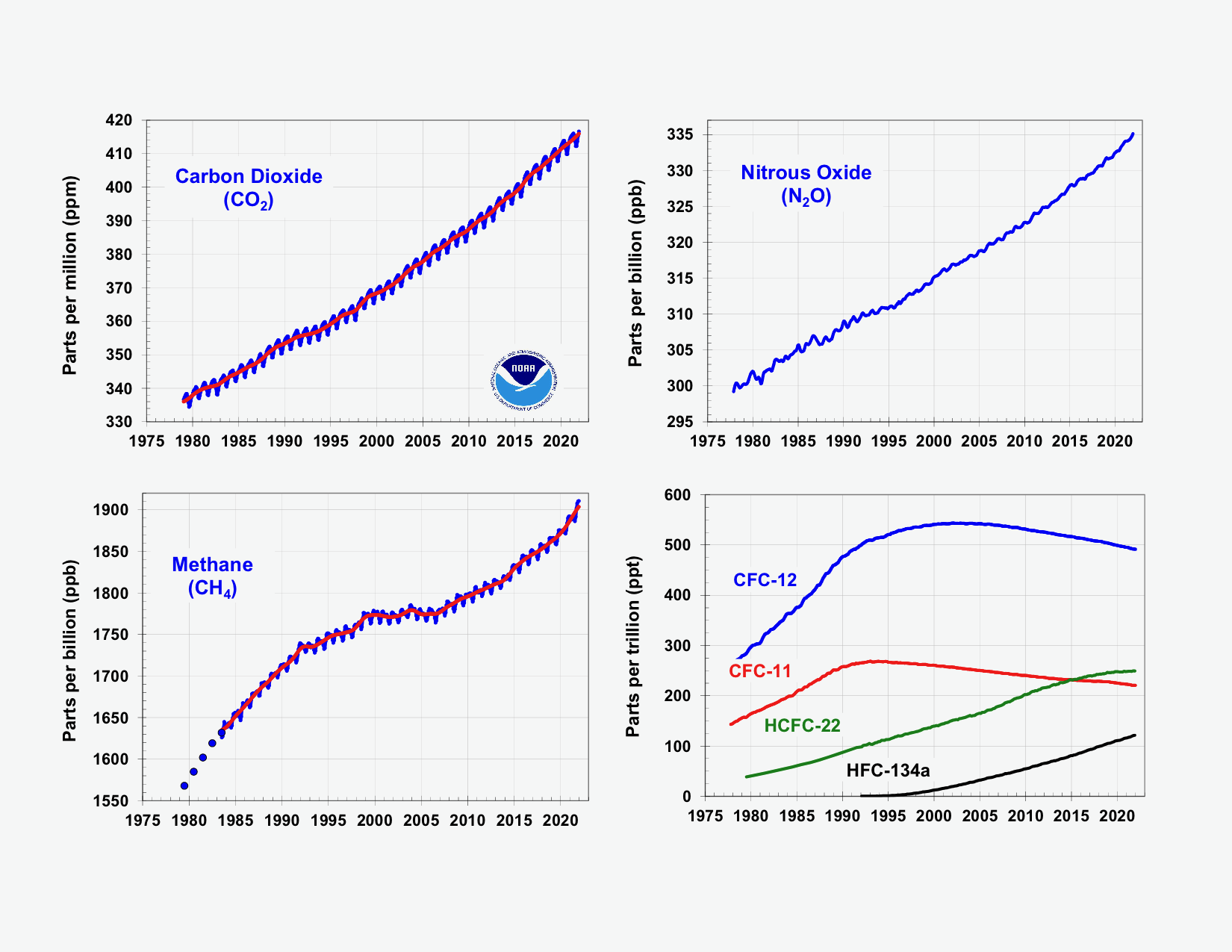
Global average abundances of the major, well-mixed, long-lived greenhouse gases – carbon dioxide, methane, nitrous oxide, CFC-12 and CFC-11 – from the NOAA global air sampling network since the beginning of 1979 are depicted here. These five gases account for about 96% of the direct radiative forcing by long-lived greenhouse gases since 1750. The remaining 4% is contributed by 15 other halogenated gases including HCFC-22 and HFC-134a, for which NOAA observations are also shown here. Credit: NOAA Global Monitoring Laboratory
The biggest culprit
Carbon dioxide, or CO2, is by far the most abundant human-emitted greenhouse gas. Roughly 36 billion metric tons of CO2 are emitted each year by transportation, electrical generation, cement manufacturing, deforestation, agriculture, and many other practices. A substantial fraction of CO2 emitted today will persist in the atmosphere for more than 1,000 years. Not surprisingly, it is also the largest contributor to the AGGI in terms of both amount and rate of increase.
NOAA measurements showed the global average concentration of CO2 in 2021 was 414.7 parts per million (ppm). The annual increase was 2.6 ppm during this year, about the average annual increase for the previous decade, and much higher than the increase measured during 2000-2009. CO2 levels have risen by 61 ppm since 1990, accounting for 80% of the increased heat tracked by the AGGI since that year.
“CO2 is the main player because it stays in the atmosphere and oceans for thousands of years and it is by far the largest contributor to global warming,” said GML Senior Scientist Pieter Tans. “Eliminating CO2 pollution has to be front and center in any efforts to deal with climate change.”
This graphic shows the increasing warming influence over time of CO2 and non-CO2 greenhouse gases, in CO2 equivalents, on the left axis. The corresponding increase in the AGGI is shown on the right axis. Credit: NOAA Global Monitoring Laboratory.
Methane: Is warming feeding warming?
One of the most important scientific questions for climate scientists is what’s been driving the sharp, sustained increase of the second-most important greenhouse gas – methane – since 2006.
Levels of atmospheric methane, or CH4, averaged 1,895.7 parts per billion during 2021. The 16.9 ppb increase recorded for 2021 was the fastest observed since the early 1980s, when a more rigorous measurement regime was initiated. Methane levels are currently around 162% greater than pre-industrial levels. From NOAA’s observations, scientists estimate the amount of methane emitted in 2021 was 15% greater than the 1984-2006 period.
Methane is the second-most important greenhouse gas in warming the globe. The warming influence of CH4 since pre-industrial times is about a quarter of that from CO2. Causes for the dramatic post-2007 increase are not fully understood, but NOAA scientists have concluded that changes in isotopic composition of atmospheric methane over time point to microbial sources, likely from wetlands, agriculture and landfills, as the dominant driver. Fossil fuel emissions, they suggest, have made a smaller contribution.
“We should absolutely target man-made methane emissions – especially those from fossil fuel – because it is technologically feasible to control them,” said Xin Lan, a CIRES scientist working in the Global Monitoring Lab. “If wetlands are giving off more methane because of warming and changes in global precipitation caused by rising CO2 levels , that’s something we can’t control directly. And that would be very concerning.”
No laughing matter
The third-most important greenhouse gas is one you may have encountered as an anesthesia in the dentist’s chair. Nitrous oxide, or N2O, is another long-lived climate forcing pollutant primarily emitted by people. It is rising every year. But it’s different in that it’s being driven by expanding populations, not energy demands. N2O pollution is primarily a result of fertilizer use to support agriculture and food production, especially for an expanding global population .
“We can find alternative energy sources to replace fossil fuels,” said Stephen Montzka, the GML scientist who leads the AGGI report each year, “but cutting emissions associated with producing food is a very difficult task.”
These three greenhouse gases, plus two banned ozone-depleting chemicals, account for about 96% of the excess heat trapped in the atmosphere due to human activity since 1750. The remaining 4% is from 16 other greenhouse gases also tracked by the AGGI. In aggregate, they trapped an amount of heat equivalent to 508 ppm of CO2 in 2021.
One number to track human impact on climate
NOAA scientists released the first AGGI in 2006 as a way to help policymakers, educators, and the public understand the cumulative impact of greenhouse gases on climate over time.
Scientists benchmarked the AGGI to the year 1750, the onset of the Industrial Revolution, assigning it a value of zero. An AGGI value of 1.0 was assigned to 1990.
The AGGI is based on thousands of air samples collected from sites around the world each year from NOAA’s Global Greenhouse Gas Reference Network. Concentrations of these greenhouse gases and other chemicals are determined through the analysis of those samples at NOAA’s Global Monitoring Laboratory in Boulder, Colorado. Scientists then calculate the amount of extra heat being trapped in the Earth system by these gases and how much that has changed over time to understand the contribution from human activity.
For more information, contact Theo Stein, NOAA Communications, at theo.stein@noaa.gov.
Click the link to read the article on the NIDIS website. Here’s an excerpt:
Key Points
Extreme and exceptional drought conditions to continue in the Intermountain West for the third summer in a row.
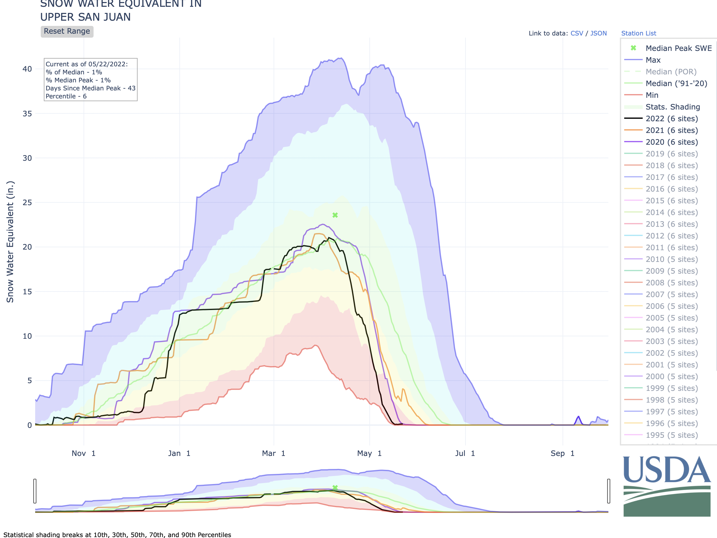
Upper Colorado River SWE is currently at 54% of median for this time of year with about a month left in the melt season.
Exceptional drought expanded in New Mexico, where the fire season is in full swing. With over 311,000 acres burned, the Hermits Peak/Calf Canyon Fire Complex is now the largest in modern records for the state of New Mexico.
The piles of snow left by last weekend’s storm have melted away, but lawns and landscapes are benefiting from the free water the storm brought to the metro area.
That means lawns won’t need extra water, in the form of sprinklers and irrigation systems, for days, even a week as more rain is in the forecast.
Denver Water saw customer demand drop by about half over the weekend as its customers did a great job responding to Mother Nature’s free water by turning off their sprinklers.
Let all that water soak in! And challenge yourself: Don’t water your lawn until it needs it. (Take the screwdriver test.) Photo credit: Denver Water.
In fact, you’re doing your lawn a favor by turning off the sprinklers and keeping them off for several days after the weekend storm — or any upcoming rain. Babied lawns that get too much water too often can have trouble with Colorado’s hotter summer months.
(And watering too much too often will drive up your monthly water bill to boot!)
“Your lawn can last longer than you think,” said Austin Krcmarik, a water efficiency expert at Denver Water. “Challenge yourself, see how long you can keep your sprinklers off.”
An easy way to test for soil moisture is to probe your lawn with a screwdriver. If it goes into the soil easily, that indicates sufficient moisture. Watch the video below to see how quick and easy this test is to perform.
While the storm dumped up to 2 feet of snow in Colorado’s mountains, it wasn’t a drought buster. (And other parts of the state didn’t see much from the storm.) Denver Water’s planners do not expect the utility’s reservoirs to completely fill this season.
“We hope to fill our reservoirs after every runoff season to help supply us through the hot summer months and into next year,” said Krcmark. “We already know that isn’t going to happen this season, but you can help keep water in our reservoirs by keeping those sprinklers off after storms.”
A general rule of thumb is that you can skip a watering day when we receive ¼ inch within 24 hours.
Weather watchers estimate the storm delivered 1 to 1.5 inches of water to the metro area. And, with the potential for more rain in Denver’s forecast, you may not need to water at all this week.
For now, Denver Water’s regular summer watering rules remain in effect, but additional restrictions could be needed if conditions warrant this summer.
Arapahoe Basin Ski Area, which is in Denver Water’s watershed where the utility collects water, reported receiving 19 inches of snow from the weekend storm. Lots of snow, though unfortunately it wasn’t a drought buster. Photo credit: Arapahoe Basin Ski Area.
Click the link to read the article on the GreenBiz website (Will Sarni & Jared Sheehan & Ben Dukes). Here’s an excerpt:
The need for a new approach to identify, fund and implement innovative water technologies and business models is critical. The impacts of climate change on water resources is well documented in places such as the American West, where the Colorado River Basin was named the most threatened in the U.S. Striking in the declaration by American Rivers was the statement that “rising temperatures and drought driven by climate change, combined with outdated river management and overallocation of limited water supplies [emphasis added], threaten the entire region.”
How can stakeholders, in particular the private sector, contribute to scaling innovative water technologies and catalyze other stakeholders to accelerate changes in public policy to adapt to 21st-century water realities? We propose the increased adoption of shadow pricing (the price of water plus consideration of risks, costs for energy and associated carbon emissions, etc.) and business value at risk strategies (additional considerations such as brand value, license to operate and grow, etc.) to overcome the challenges and barriers of using internal return on investment criteria to consider these strategies…
Our recommendations for corporations with ambitious water strategies are as follows:
Inventory and evaluate the current challenges and barriers to adopting innovative water technologies and business models to mitigate business value at risk and achieve your goals and objectives. Consider concerns such as does the company lack internal incentives to take technology risks? Or does it require too short a timeframe for investment paybacks?
Develop a framework and commitment for integrating a shadow price and for embracing a business value at risk strategy that can be used to incentivize the adoption of innovative solutions to water scarcity, poor quality and equitable access to water. You can quantify business value at risk using tools such as the WWF Water Risk Filter WAVE Tool or use a more subjective approach in which watershed-specific investments are accommodated outside of established return on investment criteria.
Build a program to identify and directly invest in innovative water technologies to increase the pipeline of innovations for considerations. Programs such as the 100+ Accelerator, PepsiCo Labs and watershed-focused venture funds such as the Future of Water: Colorado River Basin Fund (disclosure, Will Sarni is founder and CEO of the fund) increase corporate exposure to innovative solutions and opportunities for investment to support entrepreneurs.
There is an opportunity to overcome the status quo approaches to water management and stewardship. However, time is of the essence to address the impacts of climate change on critical watersheds, globally.
This car in Superior was among the victims of the Marshall Fire in late December 2021 that burned 1,084 homes and caused 30,000 residents of Superior and Louisville to flee. Photo/Allen Best
From apocalyptic disasters like the Marshall Fire, which destroyed over 1,000 homes, to soaring temperatures and high ozone levels making comfortable summer days a distant memory, to Colorado’s rapidly deteriorating air quality leaving us wondering whether it’s safe to be outside, it is clear that the effects of climate change are a threat to our health and safety.
Worse yet, there seems to be no end in sight, as experts are predicting further drought, polluted air, and wildfire conditions in every corner of the state that look like a tinderbox ready to ignite and cause devastation with even the smallest spark.
But beneath the visible impacts such as wildfires, which force people to take immediate action for their safety, lies a danger that is invisible yet no less insidious to the well-being of Coloradans — climate change is wreaking havoc on our mental health.
Every day, in every corner of the state, people are confronted with the terror of not knowing whether today is the day that a fire destroys their home, leaving behind cherished memories and permanently dismantling the sense of safety that a home represents. Given the existential dread that climate change forces us to confront, it’s no wonder that our mental health is deteriorating at the thought of this crisis that threatens our way of life.
Research about the impacts of climate change on mental health has yielded some unsettling data. In a 2021 report, the American Psychological Association found that over 75% of Americans “are concerned about climate change, and those who are most ‘Alarmed’ (about 25% of the U.S. population) nearly doubled from 2017 to 2021.”
As a licensed therapist who specializes in treating climate anxiety, I’ve seen an increase in the amount of stress my patients express about the state of our climate and its impact on them, their families, and their communities. It’s impossible to overstate how dire these impacts are on our mental well-being.
Communities that experience traumatic climate conditions, such as the Marshall Fire in Boulder County last December can see their mental health suffer greatly. Patients who have directly experienced climate-related disasters often show symptoms associated with PTSD, including flashbacks, triggers, nightmares, avoidance, depression and numbness. This affects their ability to function day to day — to parent, to work, to develop relationships, to thrive.
Studies show that climate impacts like heat and drought can contribute to anxiety disorder, schizophrenia, violence, suicide, and depression.
Some patients I see are parents grappling with a myriad of complex emotions and concerns: guilt, immobilizing anxiety, grief, anger, and themes around privilege. The uncertainty parents feel about the future of the planet that their children will inherit along with the hopelessness of not knowing whether a disaster will threaten their kids’ health and safety manifests in numerous mental health issues.
Climate change is having an impact on the mental health of all Coloradans, but poorer communities and communities of color in Colorado are more exposed to climate impacts like high heat, threat of wildfire, and high ozone. Studies show that climate impacts like heat and drought can contribute to anxiety disorder, schizophrenia, violence, suicide, and depression. It’s important that people in these communities be provided with increased access to mental health services to address the disproportionate impacts they face.
While the research shows that Americans are stressed out about climate change, it also shows that we can resolve some of this climate anxiety through therapy and investing in creating resilient communities.
Many pieces of legislation to help communities become more resilient against climate change and its impacts passed the state Legislature this year, including wildfire mitigation and disaster preparedness programs that will make communities safer when climate disasters occur. Providing communities with the funding to adequately prepare for wildfires, high heat, and drought is a great start to addressing anxiety around potential disasters and other climate impacts.
Colorado also made unprecedented investments in mental health this year. The Behavioral Health administration, which will help coordinate care and funding streams for that care, was created and hundreds of millions of dollars were directed towards all levels and kinds of treatment.
Though progress has been made, Colorado needs to continue the work to give people access to mental health services and improve the resiliency of their communities. Our leaders at the local, state, and federal level need to tackle this challenge head on both by combating climate change with aggressive action and ensuring that all Coloradans have access to the mental health resources needed to deal with the increased stress brought on by the climate disasters threatening our communities.
Colorado Newsline is part of States Newsroom, a network of news bureaus supported by grants and a coalition of donors as a 501c(3) public charity. Colorado Newsline maintains editorial independence. Contact Editor Quentin Young for questions: info@coloradonewsline.com. Follow Colorado Newsline on Facebook and Twitter.
KATE Greenberg, agriculture commissioner for Colorado, is leaving Cactus Hill Farm in Conejos County when she reflects on the farm operations she’s visited so far on her weekend tour of the San Luis Valley.
Greenberg had made stops at the non-profit Rio Grande Farm Park in Alamosa, the large-scale Esperanza Farms managed by Virgil Valdez, and then the niche Cactus Farm where Elana Miller-ter Kuile spoke about the unsustainable nature of fast fashion that the wool farmer sees in an era of water scarcity and climate change.
It was during her time as western program director for the National Young Farmers Coalition that Greenberg would begin to acquaint herself with the area, particularly neighboring New Mexico where she was schooled on the practice of acequia farming and the generational ties to agricultural lands in the high-desert terrain of the region.
It’s been pointed out that she is the first female ag commissioner for Colorado, and maybe the youngest ever after she was appointed to the position in 2018 by Gov. Polis. What’s less described is her ease of command on the issues facing farmers at different scales of operation, and her willingness to engage in the divide between Front Range and rural Colorado as it wrestles with issues like the affluent bedroom community of Douglas County looking to raid the aquifers of the San Luis Valley to quelch its population thirst.
On her visit to the Valley, she sat in the living room of Virgil and Sherry Valdez at Esperanza Farms and heard about fears of getting crops out of the ground and to market this summer due to the lack of farm labor. Earlier she spent time with Jesus Flores and conversed entirely in Spanish with the Rio Grande Farm Park manager, and helped bottle-feed newborn sheep at Miller-ter Kuile’s Cactus Hill Farm.
Across America agricultural leaders like Greenberg wrestle with how to balance the rise of corporate farms that have sliced away at mid-level farming and ranching operations but left a bit of space for the family farmer, community organic operations, and enterprising people like Elana Miller-ter Kuile who clearly has found a niche in the wool-making world.
“Here in the Valley I feel like the different scale, whether it’s very small, or very large, or somewhere in between, it’s all about how do you support your family, support your business, take care of the land and find a market,” Greenberg said.
“I think all of the different operations we’ve seen, whether it’s Rio Grande Farm Park helping families provide food for themselves or for farmer’s markets, Elana selling wool all across the country, or Virgil and Sherry (Valdez) growing for potato sheds for exports, all of that has a place in our ag economy and you could see that just within a few miles of each other here.”
She grasps the very real burnout of farmers and the disappearance of the next generation of ag producers, but even there she found new hope in what’s happening across the San Luis Valley to maintain an agricultural sector.
Her trip into San Luis and Costilla County to attend Saturday’s Congresso de Aquequias 2022 and to learn about the Move Mountains Youth apprenticeship in acequia farming gave her more thought and more ways to move forward in her job handling Colorado’s $7 billion ag economy.
“I think from my experience throughout the years in New Mexico in particular, I come here humbly,” Greenberg said. “Even though I was invited to speak (at the Congresso), I intend to listen a lot more than I speak. I have a farmer friend whose dad always said, ‘We were born with two ears and one mouth for a reason.’ So I hope that’s what I can do, is listen and learn from the folks in San Luis.”
In this video interview with Colorado Agriculture Commissioner Greenberg, she reflects more on the job of ag commissioner, her visit to the San Luis Valley, and why the Renewable Water Resources exportation plan is the wrong approach for managing water in Colorado. Watch our car-ride interview with Commissioner Greenberg:
Clean water is essential to all life. As we mark the 50th anniversary of the Clean Water Act this year, we should be moving forward – not backward – when it comes to safeguarding clean, accessible, safe, affordable water for all.
Why is Section 401 of the Clean Water Act important – what does it do?
The Clean Water Act helps prevent water pollution. Section 401 of the Clean Water Act gives states and certain tribes authority to place conditions for the protection of water on permits and licenses for the construction and operation of projects that could harm rivers, streams, and other water bodies. These protections ensure that infrastructure projects, such as dams or pipelines, won’t pollute our water or otherwise negatively affect water quality. Section 401 also allows states and tribes to work with the federal government to ensure that rivers are protected and that projects meet the needs of local communities.
What did the Supreme Court rule, and what’s the impact for rivers?
In 2020, the Trump Administration’s EPA made drastic changes that limit the way states and tribes can apply Section 401. The changes unraveled 50 years of practice and cooperation between the federal government and states and tribes in the administration of these protections. American Rivers, along with our allies, sued to overturn the rules and successfully convinced a District Court to nullify the 2020 rule while the current EPA works to revise them. A few states, the fossil fuel industry and the hydropower industry appealed to the Supreme Court and asked that the Supreme Court reinstate the 2020 rule until the current EPA successfully completes its process to change the rules in 2023. The result of this decision is that it will be more difficult for states and tribes to protect water. For example, the 2020 rules prohibit states and tribes from weighing climate change and its impacts in making conditioning decisions and it restricts conditions to addressing only point source pollution.
What happens now — what are the next steps?
American Rivers is not giving up because these clean water protections are too important. The Supreme Court did not provide a rationale for why they reinstated the 2020 rule, but the message appears to be that they found it inappropriate for the lower courts to nullify the rule without making a determination on the merits of the arguments each side had raised. American Rivers and our partners at American Whitewater, Idaho Rivers United, and California Trout will continue to make our case in the federal courts for why this rule should be overturned. We will also work with the EPA to make sure that the new rule due in 2023 will fix the flaws in the 2020 rule.
Horizontal sprinkler. Photo credit: Allen Best/Big Pivots
Click the link to read the article on the Big Pivots website (Allen Best):
A Kansas farm boy goes home to understand his role in groundwater depletion. He finds the culture and politics as confused and confounding as the geology of the Ogallala Aquifer itself.
Simple metrics of the Ogallala Aquifer astound. This somewhat interconnected body of water underlying the high plains accounts for one-third of all irrigation in the United States. It supports one-sixth of the world’s annual grain production.
Water in the underground sands, silts, and gravels stretching from South Dakota to Texas – including parts of eastern Colorado — was deposited over millions of years. Now, in not even a flutter of geologic time, barely more than the lives of the oldest baby boomers, this most precious resource has been mined nearly to extinction across broad swaths of the High Plains.
This is particularly true along its edges, such as in New Mexico, but even in some central portions, including southwestern Kansas. Wells can be drilled deeper, but that can only hasten the reckoning that many seem to want to deny. The seeming plentitude of today manifested in the many circles of hay and alfalfa irrigated by center-pivot sprinklers simply cannot continue indefinitely. Evidence of precipitous decline abounds.
Lucas Bessire, an anthropologist and native son of southwestern Kansas, explores this depletion in his masterful “Running Out: In Search of Water on the High Plains.” For good reason it was a finalist for the 2021 National Book Award.
Depletion of the Ogallala Aquifer has produced several books plus other journalism. Bessire has a more narrow but interesting approach. Instead of trying to tell this across the eight-state region, he focuses on southwestern Kansas through the lens of four generations of his family: a great grandfather who was a pioneer in this new groundwater mining of the mid-20th century, his grandmother who was at its ragged hard-to-reconcile edges, and a father from whom Bessire was at least semi-estranged but who becomes, in this book, a partner in detective work.
Not least Bessire’s book is of his own journey to the place of his upbringing to examine it with new eyes, as if a stranger, and in that way probe his own complicity.
Always in these pages Bessire looks over his shoulder, both to his family but also of the region’s history, rife with depletions of earlier times. In this, he seeks to make sense of the present so as to take responsibility for the future. In this struggle to define what it will take to live in a more sustainable way in the world, he takes guidance from his long-departed grandmother. She had in her life struggled to end her dependency on alcohol, drugs, and tobacco. The first step, she wrote in notes now a half-century old, “is to admit that I am not responsible for the past, but that I am accountable to tomorrow.”
That observation borne of his grandmother’s pain is one for all of those of Ogallala Country – and, although Bessire does not dwell on this, all of humanity.
Working through the many big ideas in “Running Out” never taxes. Every page has sentences to be savored and, in my case, paragraphs to be highlighted in yellow, for later savoring and deepened understandings.
“Running Out” has a dreamy, confusing theme, one clearly intended. In his quest to understand, Bessire finds mazes of depletion, layers of deception, a dried river, and a waterless spring that was part of his family’s operation, an area where hydrologists now estimate three-quarters of the water has been removed. There are clouded memories, a strange mist, a numbing vapor, and a ghostly presence.
Always, there is ghost of his grandmother who in her life was subjected by her handlers to electroshock therapy in an attempt to create amnesia. She spent the rest of her life, says Bessire, trying to recapture the water of her youth that had disappeared.
There are also blurred boundaries, conundrums, and contradictions, plus the confounding logic used to justify the depletion. Meetings of the groundwater management districts that he and his father attend showcase this distorted logic.
These districts, under Kansas Law, have authority over the depletion. At one meeting, he attends in expectation of debate about the future of the aquifer, he instead finds blandness, words, and a mood “strangely flattened and trivial, as if veiled behind some gauzy medium that muffled words and distorted time.” The gatherings of aging white men he describes as dishonesty disguised by dullness.
Kansas Aqueduct route via Circle of Blue
At one of these meetings, “John,” whom he describes as the official playing the part of emcee, belabors the distinction between “impairment,” a word he discourages, and his strong preference, “drawdown allowances.” The talk then extends to the solution, imported water.
Another meeting produces more fuzzy logic: Imposing limits on pumping does not provide an answer because it would force the transition of irrigated land to less valuable non-irrigated farm land and hence a yanking of the economic platform for the region. As such, depletive irrigation must continue. Again, the answer to the inevitable lies in importing water from elsewhere, presumably with the federal government footing the bill for a canal (and pumps) from the Mississippi River.
Ogallala Aquifer. Credit: Big Pivots
That solution is only slightly less improbable than the giant machines that some envision for sucking carbon dioxide out of the atmosphere.
The federal government played a role in creating this mess through its insurance programs for crops that favor irrigation, says Bessire. Even more clearly he blames corporate agriculture, the majority owners of the land in this county of southwestern Kansas and the mostly hidden influence that makes the groundwater districts forums for doublespeak. A few farmers use disproportionate amounts of water, and those farmers advocating for restraint in pumping have little voice. The exploitation, he says, is anti-democratic.
Bessire’s four chapters – Lines, Bones, Dust, Clouds – are carefully crafted, at least partly a result of a year’s fellowship at Harvard University. The prose constantly delights. Driving in the night with his father, he observes “the spinning pivots, under the turning stars.” On another trip through “towns with courthouse squares and false fronts” he sees “emptied houses (that are) falling down in arrested motion.”
Exploitation, extinction, and extermination are subthemes to his focus on depletion. He tells of the killing of the once vast bison herds that virtually disappeared in a burst of gluttony in 1872-74. The buffalo bones at the railroad siding in Granada, in southeastern Colorado, were 12 feet high, 12 feet wide, and a half-mile long. Most of the buffalo hunters made no money, he observed – a metaphor, if you will, for the farmers depleting the aquifer today.
The buffalo extermination was also a somewhat conscious decision, a way to force Native American tribes off the land so it could be farmed and ranched. Part of this was the Sand Creek Massacre, whose site in Colorado, just across the border from Kansas, he visited in the company of his grandmother in the 1990s. He wonders at his own lack of understanding of this history that was prelude to his existence there, a child of the plains. “We lived among the rubble of genocide and dispossession in a landscape that had been transformed,” he says.
No mention is made of critical race theory, but this conclusion does invite comparisons.
The book has no spare baggage. It has disciplined focus reflected in its relative brevity that belies enormous research. There’s no fat here. The bibliography cites more than 400 books and other sources. His telling of the Sand Creek Massacre, something I have ready deeply about, illustrates this depth.
One might have wished for just a bit more in two areas. A groundwater district in northwestern Kansas in 2017 voluntarily adopted restrictions on the pace of decline. Bessire explains this but does not identify what was different there, why corporate interests did not prevail.
The second element is about the end result of the water pumping. Most crops grown with Ogallala drafting feed livestock. Bessire addresses this – really, it’s at the heart of his book:
“The scale of industrial farming is staggering,” he says. “Southwest Kansas is home to some of the nation’s largest corporate feeders, beef- and poultry-packing plants, slaughterhouses, dairies, milk-drying plants, and hog farms. Multinational meat-packing companies operate slaughterhouses that process several thousand cattle each day. All are billion-dollar businesses. They drive farmers’ choices to produce corn, silage, sorghum, or alfalfa. Their profits depend on aquifer deletion. In other words, there is a multibillion-dollar corporate interest to prevent regulation and to pump the water until it’s gone.”
I might have liked to have seen this livestock story developed more fully, another full chapter, actually. Maybe it’s another book, a sequel.
Trucks deliver the corn harvest at a feedlot near Imperial, Neb. Photo/Allen Best
The cost of eating meat is heavily, heavily subsidized and cannot continue at its current pace. We are borrowing against the opportunities of future generations with no clear way to pay that debt. I am, by the way, a meat-eater.
This conclusion was derived in part from my own research into the Ogallala in the context of eastern Colorado. My work has been marginal. My commissioned assignments have been to extol the efforts made to innovate. I was not given a blank check to investigate, nor did I take a second-mortgage on the house while I asked the hard questions that Bessire did (he camped out in the barn of his father).
But I sensed what Bessire explains in his opening, that “depletion of the High Plains aquifer is a defining drama of our times. Within it, planetary crises of ecologies, democracy, and interpretation are condensed. It demands a response.”
To that I will add a quote from my most recent interviews, a water district official who said that ultimately Ogallala farmers are selling water. As such, he said, they should be mining the groundwater for high-value crops.
Truth searching rarely comes easily. Geology can be very complex, too. In his opening passage, Bessire tells us about the difficulty of working through the politics and cultures of depletion.
“The sediments are vertically stacked in layers. They are patchy and unevenly spread. Repetitive themes run between them: memory and amnesia, homelands and exile, holding on and letting go. At times, the layers flow together and connect. At others, they are interrupted and blocked.”
That he emerged with a book worthy of being considered for the nation’s top book-writing award testifies to his success in navigating these physical and other subterranean passages.
Water flows in the Colorado River Delta. Photo: Claudio Contreras Koob
Click the link to read the article on the Audubon website (Jennifer Pitt):
The Colorado River is once again flowing in its delta. The flows, which began on May 1, are the result of binational collaboration and deliberate management. The water is dedicated to supporting the ecosystem and local communities in a landscape where the river has not flowed for most years in the past half century. It is a heartening bit of good news for the Colorado River, which earlier this year was designated as America’s most endangered river.
This year’s flow will be very similar to the managed flow in the delta in 2021. The water purposefully bypasses the driest reaches of the delta, diverted from the Colorado River at the border into Mexico’s irrigation system, where it travels via concrete lined canals to be reconnected with the river some 40 miles downstream. From there water flows down the river’s channel, past more than 1000 acres of painstakingly restored riverside forest, towards the Upper Gulf of California. Like last year, this year’s flow is about 35,000 acre-feet of water (11.4 billion gallons), delivered over nearly 5 months from May 1 to September 20. In a year where we cannot seem to escape horrible news about climate change, wildfires, and water shortages, the delta flow is a sign that it is still possible to improve management on the Colorado River. As climate change impacts continue to bear down on the region, this type of management will be more important than ever.
Dozens of scientists are deployed to the field to measure the impact of this water delivery and provide suggestions for how to use a managed flow to improve environmental benefits in a region known to support some 380 bird species including Yellow-billed Cuckoos and Heermann’s Gulls. With continued input of scientists over the years, the design of these flows aims to optimize the location and timing of water deliveries to support restored and remnant river habitats, the birds that use them, and residents of nearby Mexican communities that are rediscovering a river in their midst.
The managed delta flow is the result of improved hydro-diplomacy between the United States and Mexico. The U.S. and Mexican sections of the International Boundary and Water Commission, along with federal water agencies in both countries—the U.S. Bureau of Reclamation and CONAGUA—today operate under Minute 323, a 2017 treaty agreement that modernized Colorado River management first established in a 1944 Treaty. Minute 323 recognizes the value of water for the environment, for the river itself, a value the original Treaty did not consider.
Minute 323 may sound like an arcane bit of law, but consider its impact: in 2022, for the first time, a shortage was declared on the Colorado River, and Mexico along with Arizona and Nevada received less than its full allocation of water (there is a parallel U.S. domestic agreement, the Lower Basin Drought Contingency Plan). This could have been the beginning of a major international conflict—in the 1960’s more than 10,000 Mexicali farmers protested for days on the steps of the American consulate in response to degraded Colorado River water quality from the United States, and eventually Mexico’s President Echeverria brought the concern to an Oval Office conversation with President Nixon. But in 2022, the United States reduced deliveries of Colorado River water to Mexico, and with Minute 323 in place, it was implemented without remark.
As climate change continues to aridify the Colorado River basin, and water availability continues to decline, the provisions in Minute 323 to share water shortages proportionally – equitably – stands as a model of good management. It might even be a helpful model for the seven U.S. states (Ariz., Calif., Colo., N.M., Nev., Utah, and Wyo.) that must develop shortage-sharing agreements among themselves sufficient to adapt to the river’s declining water supply.
Minute 323’s impact goes further: under its provisions, the United States committed millions of dollars to help upgrade agricultural water supply infrastructure in the Mexicali Valley, and Mexico has conserved and stored more than 150,000 acre-feet of water in Lake Mead in the United States, helping to prop up water storage in a reservoir that is dwindling too quickly.
Under Minute 323, the United States and Mexico successfully began to manage the declining Colorado River water supply, helping to improve conditions for water users in both countries, while also making environmental water commitments. Colorado River water users and river lovers alike owe a debt of gratitude to the leaders who negotiated Minute 323, and should ask for nothing less from future Colorado River management agreements.
Click the link to read the article on the Pagosa Sun website (Josh Pike). Here’s an excerpt:
A May 16 press release from Pagosa Area Water and Sanitation District (PAWSD) District Manager Justin Ramsey urges residents to reduce water consumption due to worsening drought conditions.
It states, “The NRCS SnoTel station reached a Snow Water Equivalency (SWE) of 0” on May 10th a full three weeks quicker than the median. The median date for reaching a SWE of 0” is May 31st.
“Per the Districts Drought Management Plan we would have triggered the Voluntary Drought Stage had the SWE occurred 2 days earlier on the 8th of May.
“Although we are not in a Voluntary Drought Stage, the unseasonably high temperatures and winds will make for a high water use season. Our weekly water use has increased by 2 million gallons over last years weekly usage.
“The District is requesting everyone conserve water and use outside irrigation sparingly. Please do not water between 9:00 am and 6:00 pm. Watering during the hottest part of the day wastes water as a significant portion of the irrigation water evaporates prior to percolating into the soil, wasting not only water but your money.
Drought outlook
Stream flow for the San Juan River on May 18 at approximately 9 a.m. was 1,120 cubic feet per second (cfs), according to the U.S. Geologi- cal Service (USGS) National Water Dashboard, down from a nighttime peak of 1,320 cfs at 2 a.m.
These numbers are down from May 11, when the river flow was at 1,390 cfs at 9:15 a.m. with a nighttime peak of 1,830 cfs at 12:15 a.m.
As referenced in Ramsey’s press release, the U.S. Department of Agriculture (USDA) National Water and Climate Center’s snowpack report at the Wolf Creek summit, at 11,000 feet of elevation, had zero inches of snow water equivalent as of 11 a.m. on Wednesday, May 18. The report also notes that the San Miguel, Dolores, Animas and San Juan river basins were at 4 percent of the May 18 median in terms of snowpack.
Colorado State Capitol. Photo credit: Allen Best/Big Pivots
Click the link to read the article on the Ark Valley Voice website (Jan Wondra). Here’s an excerpt:
HB22-1362 (Energy-Efficient Building Codes) This landmark bill increases the statewide minimum performance requirements for building energy codes, requiring cities and counties to increase efficiency and cut pollution from homes and commercial buildings when updating their local codes.
The bill requires local governments to introduce electric- and solar-ready code language beginning in 2023, followed by low-energy and low-carbon code language beginning in 2026. Finally, the bill invests more than $20 million in energy efficiency and building decarbonization projects. SWEEP thanks Representatives Tracey Bernett and Alex Valdez along with Senators Chris Hansen and Faith Winter for leading this effort…
SB22-206 (Disaster Preparedness and Recovery Resources) This bill was crafted in the wake of the devastating Marshall Fire. It provides $20 million to the Colorado Energy Office to distribute as loans and grants to help Coloradans rebuild efficient, resilient, and high-performance homes after wildfires and other climate disasters; and $15 million to the Department of Local Affairs to help fund resilient recovery efforts after disaster emergencies.
It also establishes an Office of Climate Preparedness to coordinate the state’s post-disaster recovery efforts and develop a statewide climate preparedness plan.
HB22-1218 (EV-ready Building Codes) This bill requires builders to future-proof new and renovated commercial and multifamily buildings for electric vehicle (EV) charging. For parking spaces in these buildings, adding such infrastructure during the initial construction phase is up to six times less expensive than adding charging later as a stand-alone retrofit.
Colorado anticipates nearly one million EVs on its roads by 2030, requiring more than half a million EV charging stations at homes, businesses, shopping centers, and highway corridors, so it makes sense to future-proof new buildings with the panel capacity and wiring to accommodate EV charging…
HB22-1026 (Transportation Options Tax Credit) This bill will help employers support employees that commute to work using an energy-efficient mode such as transit, a bicycle, or a vanpool. The credit is available for two years and covers 50 percent of the cost of providing clean transportation options.
To receive the tax credit, employers must offer clean transportation options to all employees, including part-time and contract workers, which will ensure the benefits are available to all workers including those who don’t have the option to work from home.
SB22-118 and HB22-1381 both focused on geothermal energy. The first bill passed, and the second was laid over. These two bills would help building owners and communities deploy energy-efficient geothermal heat pump systems to heat and cool buildings and/or provide hot water.
HB22-1151 (Turf Replacement) This bill would reduce water use for lawn irrigation and conserve electricity that otherwise would have been used for pumping. The Colorado Water Conservation Board would be required to create a program for Coloradans that would financially incentivize them to voluntarily replace their irrigated turf with water-wise landscaping. Rep. Dylan Roberts one of its sponsors, has been one of the many voices behind recent efforts in Eagle County to move toward drought-tolerant landscaping there.
Scott writes in email, “Some locals say it’s the biggest dust on snow event they’ve seen…”
Flat top mountain May 19, 2022. Photo credit: Scott HummerDust on Snow – Big Flat Tops May 19. 2022. Photo credit: Scott HummerDust on Snow – Big Flat Tops May 19, 2022. Photo credit: Scott HummerDust on Snow – Flat Top Mountain May 19, 2022. Photo credit: Scott Hummer
In case your memory about conditions in the high country has been dulled by yesterday’s beautiful snowfall.
Update: Here’s a photo 24 hours after the dust on snow event in the photos above.
Flat Top Mountain May 20, 2022. Photo credit: Scott Hummer
The North Fork Mancos Master Development Plan would have allowed 35 new fracking wells in the North Fork Valley and Thompson Divide areas
A U.S. District Court judge vacated a federal plan that allowed fracking across 35,000 acres of Colorado’s Western Slope on May 20.
The North Fork Mancos Master Development Plan would have allowed 35 new fracking wells in the North Fork Valley and Thompson Divide areas of the Grand Mesa, Uncompahgre and Gunnison national forests that provide habitat for elk, black bear and the imperiled Canada lynx and drinking water for downstream communities. Judge Marcia K. Krieger’s order prevents new drilling and fracking in the area.
“This is a victory for the integrity of a biologically and economically diverse area,” said Melissa Hornbein, a senior attorney with the Western Environmental Law Center. “It reinforces that the federal government can’t skirt disclosing the environmental impacts of its actions. The Bureau of Land Management has to confront the dissonance between its proposal for fracking in an area already disproportionately affected by climate change and the reality that, to maintain any chance of keeping warming below the critical 1.5°C threshold, the government cannot approve any new fossil fuel projects.”
Today’s order stems from a 2021 lawsuit by conservation and climate groups challenging the U.S. Bureau of Land Management and the U.S. Forest Service for failing to analyze potential water and climate pollution, or plan alternatives that would prevent such harm. The plan would have caused about 52 million tons of greenhouse gas pollution, equivalent to the annual pollution from a dozen coal-fired power plants.
“In this case, BLM acknowledged deficiencies in its analysis. Based on the court’s ruling, the agency must start over if they’re going to approve fossil fuel development in the area,” said Peter Hart, an attorney with Wilderness Workshop. “This will give BLM a chance to reconsider whether this is the right decision in the first place, and to contemplate alternatives that don’t destroy the headwaters of the North Fork, pristine roadless areas and our climate.”
Colorado’s Western Slope is already suffering from severe warming. The Washington Post featured the area as the largest “climate hot spot” in the lower 48 states, where temperatures have risen more than 2 degrees Celsius. The temperature rise is reducing snowpack and drying Colorado River flows that support endangered fish, agriculture and 40 million downstream water users.
“Today’s ruling is an important victory for the North Fork Valley community because it ensures government accountability and protects our vital public lands, water resources and climate from misguided oil and gas development plans,” said Natasha Léger, executive director, Citizens for a Healthy Community. “The government’s concession that its analysis of the project was inadequate would not have occurred without this citizen-led lawsuit.”
“We’re thrilled that today’s decision protects the spectacular public lands, wildlife and waters of the Upper North Fork,” said Matt Reed, public lands director for Gunnison County-based High Country Conservation Advocates. “Furthermore, this ill-conceived project would have impacted critical headwaters that sustain a significant organic agriculture industry immediately downstream in Delta County, whose farms are an important source of produce for Gunnison County individuals and businesses.”
Several analyses show that climate pollution from the world’s already-producing fossil fuel developments, if fully developed, would push warming past 1.5 degrees Celsius, and that avoiding such warming requires ending new investment in fossil fuel projects and phasing out production to keep as much as 40% of developed fields in the ground.
“The judge’s order has spared forests, creeks and wildlife from fracking industrialization and prevented dangerous climate pollution along Colorado’s spectacular Western slope,” said Taylor McKinnon at the Center for Biological Diversity. “Now It’s time for President Biden to keep his promise and stop all new oil and gas expansion on our public lands and waters. His urgent action can help save the Colorado River basin, and the planet, for future generations.”
Thousands of organizations and communities from across the United States have called on President Biden to halt federal fossil fuel expansion and phase out production consistent with limiting global warming to 1.5 degrees Celsius.
“Climate action starts in places like Colorado’s North Fork Valley, where it’s absolutely vital to keep fossil fuels in the ground and protect the region’s clean air and water, public lands and wild places,” said Jeremy Nichols, climate and energy program director for WildEarth Guardians. “This lawsuit win is a critical victory for the climate and for western Colorado’s North Fork.”
Plaintiffs Citizens for a Healthy Community, Wilderness Workshop, High Country Conservation Advocates, Center for Biological Diversity and WildEarth Guardians are represented in this litigation by Western Environmental Law Center.
Background: Fossil fuel production on public lands causes about a quarter of U.S. greenhouse gas pollution. Peer-reviewed science estimates that a nationwide fossil fuel leasing ban on federal lands and oceans would reduce carbon emissions by 280 million tons per year, ranking it among the most ambitious federal climate-policy proposals.
Oil, gas and coal extraction uses mines, well pads, gas lines, roads and other infrastructure that destroy habitat for wildlife, including threatened and endangered species. Oil spills and other harms from offshore drilling have inflicted immense damage to ocean wildlife and coastal communities. Fracking and mining also pollute watersheds and waterways that provide drinking water to millions of people.
Federal fossil fuels that have not been leased to industry contain up to 450 billion tons of potential climate pollution; those already leased to industry contain up to 43 billion tons. Pollution from the world’s already producing oil and gas fields, if fully developed, would push global warming well past 1.5 degrees Celsius.
Last week, [a Colorado online daily] ran an opinion piece about the dwindling Colorado River and what role agriculture may or may not play in helping to shore it up. It was written by Don Schwindt, a Cortez, Colorado, farmer, and Dan Keppen, Executive Director of the Family Farm Alliance. Along with praising a Southwestern Colorado dam, they argue that agriculture is important and “must be protected by ensuring water remains on-farm.”
They go on to say:
“Now, the narrative in some recent media coverage is even more troubling. For some, the current severe drought provides a platform to advocate taking water from farmers to make more available for cities and the environment.
“The hydrology of the West may be changing, but that should not drive hasty decisions. Agricultural water cannot be simply viewed as the default “reservoir” to meet other growing water demands.”
They are referring to “demand management,” which can include encouraging farmers to plant less thirsty crops, to increasing efficiency, to paying farmers to stop watering their fields and leave the water in the river (either buying water rights and permanently transferring them, or leasing them when needed on a temporary basis).
As I read the piece, I was struck less by the arguments, which were fairly predictable, than by my reactions to the arguments. One sentence would have me scoffing, the next nodding in agreement, and another both nodding and snorting derisively. That’s not because I’m insane. It’s because these issues—the “Law of the River,” agriculture’s role in culture and ecosystems, and the Colorado River system—are complicated as all get out. And that sometimes means that the only workable solutions to the growing problems on the river are not always vary palatable. I like farmers, for example, but I also like rivers and the fish in them. It’s getting more and more difficult to have both.
The following is an attempt at a Data Dump response of sorts to the column.
The Colorado River is facing a serious supply-demand imbalance. A century ago, when the framers of the Colorado Compact got together to divvy up the river’s waters, they made a few mistakes. First, and most egregious, they didn’t include tribal nations in the negotiations, despite the fact that tribes are sovereign nations and collectively are entitled to first rights to all the water in the river. That was just wrong. Second, they overestimated the amount of water in the river, which in some ways was an honest screw up, given the records they had to work from. And, third, they parceled out too big a portion of the water they thought was in the river, leaving too small of a buffer in case their calculations were off (they were).
Natural Flow is an estimate of how much water would have naturally run past Lee’s Ferry if there were no dams or diversions upstream. It is calculated using the actual flow, historic flows, and upstream consumptive uses. Bureau of Reclamation modeling is complete to 2019; I extrapolated 2020 and 2021 based on Lake Powell inflows. The 1922 Colorado River Compact gave 7.5 million acre feet to the Upper Basin, 7.5 MAF to the Lower Basin, and (in the ‘40s) 1.5 MAF to Mexico, based on early 1900s observations. As the graph above shows, the average flows dropped below that level a decade later and stayed there aside from a brief respite in the 1980s. Source: USBR
The result: The river is over-allocated, and would be even if climate change were not a factor. So, supply was already lagging behind demand two decades ago, when the Southwest entered the megadrought in a dramatic way (i.e. 2002, the year of our desiccation). Now the supply is diminishing while demand holds steady, which is rapidly drawing down Lakes Powell and Mead (and other reservoirs). With those huge water “banks” at a critically low level, the Colorado River Basin is at its breaking point. Demand must be slashed, quickly and significantly.
While overall demand on the Colorado River trended upward from 1970 to the late 1990s, it plateaued when the region entered the current megadrought. Although this data only goes to 2010, the plateau has pretty much held. But at over 14 MAF per year, demand is significantly higher than what the river has supplied most years. Note that more water is lost to reservoir evaporation than is sent to Mexico. Source: USBR Colorado River Basin Water Supply and Demand Study.
The logical way to make big cuts in consumption is to go to the biggest consumers. And the biggest user of Colorado River water, by far, is not lawns, not golf courses, not the Bellagio fountain in Vegas. It is agriculture: all of those orchards, cornfields, alfalfa fields, ranches, and so on. It’s true in the Upper Basin, in the Lower Basin, and in each state except Nevada, which uses virtually all of its relatively minuscule portion of the river to keep Las Vegas from shriveling up and dissolving back into the desert.
Please visit this post at http://LandDesk.org to see larger, higher resolution images. Note that in New Mexico energy takes up a relatively large share of water. This is mostly for the coal-fired power plants in the Four Corners region, which use billions of gallons of water each year for cooling, steam-generation and other purposes. In some cases, some of this water is returned to the river, but the San Juan Generating Station—scheduled to close this year—is a zero-discharge facility, meaning all of its water use is “consumptive.” Source: USBR.
Farms’ outsized water guzzling may seem surprising, especially since residential development has been gobbling up farmland in recent decades and ag makes up a smaller and smaller portion of these states’ economies. But crops need water in the arid West and, besides, the farmers tend to have most of the water rights. And Western water law and custom encourage folks to use all of the water they have a right to, conservation be damned—the motto, “use it or lose it,” is pounded into many a Western irrigator’s head: Take all of the water to which you’re entitled and then some, whether you need it or not, or else it might end up on your neighbor’s field or, God forbid, flow back into the river!
Montezuma Tunnel entrance.
Schwindt/Keppen write, in reference to diverting Dolores River water onto the farms of Southwest Colorado’s Montezuma Valley:
“The valley’s irrigated ecosystem also improved, further enhancing critically important environments for wildlife and generating other cultural benefits. Irrigated agricultural lands provide groundwater storage, open space, and riparian habitat and wildlife corridors. They also serve as important buffers between public wildlands and expanding urban and suburban areas.”
And it’s true, kind of. It’s a stretch to say irrigation enhances the existing ecosystem, but it certainly creates its own, new ecosystems which can be quite vibrant and beautiful. Leaky ditches are especially good at feeding new wetlands, willows, cattails, cottonwoods, and birds and other wildlife. But what irrigation bestows on previously arid landscapes, it takes from once wild rivers. That is especially true on the Dolores, where in the late 1800s irrigators began diverting its waters out of the Dolores River watershed and into the San Juan River watershed, meaning the runoff did not go back into the river. That essentially dried the lower Dolores right up.
The same was happening all over the region. In the late 1880s ichthyologist David Starr Jordan surveyed area rivers. Here’s what he observed, not about the Dolores, specifically, but about the general state of streams in Colorado at the time:
Via The Land Desk.
But then came the Dolores Project, McPhee Dam and Reservoir, which Schwindt and Keppen say “put water in the dry Dolores riverbed.” Well, no, not really. What it did is take water out of the river during spring runoff and then release some of it later in the year into the riverbed that had been dried out by irrigation diversions.
The dam started impounding water in 1983, in the midst of a string of unusually wet years. During that era, the dam did its job. The current irrigators got a more stable supply of water. The Ute Mountain Ute Tribe got both drinking water from the project as well as enough to irrigate a major agricultural enterprise near the toe of Ute Mountain, providing much needed economic development. The Town of Dove Creek receives water from the project as do the formerly dryland farmers, allowing them to diversify their crops. And still the year-round flows below the dam were enough to build and sustain a cold-water fishery for trout in the first dozen or so miles below the dam and a habitat for native fish below that. In some ways the dam had set the stage for a win-win-win situation.
The Dolores River shows us what’s at stake in the fight to protect the American West — Conservation Colorado
Until it didn’t. That riverbed below the dam? It’s dry more years than not. Last year farmers had to fallow some or all of their fields. The Ute Mountain Ute Tribe received only about 10 percent of its usual irrigation water, forcing it to fallow fields; the Town of Dove Creek faced the prospect of losing its drinking water supply altogether; and releases from the dam for the lower river were cut to 10 cubic feet per second, a mere trickle. For several consecutive weeks in June and July the river gauge at Slickrock registered zero. Fish died off, boating has been nearly non-existent most years, and the dearth of high spring water has allowed tamarisk and Russian olive to proliferate.
This spring’s flows on the Dolores River above the dam have actually been somewhat healthy, peaking out (rather early) at nearly 2,000 cubic feet per second.
And yet virtually none of that is making it past the dam (yes, that flat black line at the bottom represents releases. It’s at about 7.5 cubic feet per second, a mere trickle, and water managers say they will increase it to a whopping 25 cfs later this year, which is about enough to float a stick):
And even with good flows and low releases, Dolores Project irrigators are expected to get only 18% of their allocation this year. That’s up from 10% last year, but still. The dam isn’t doing the job it’s meant to do, which is to insulate users from drought. And yet, Schwindt and Keppen say the solution is not to try to reduce demand, but rather to “seriously assess projects that enhance water supplies.” They and the Farm Alliance suggest forest restoration, as well as building more water storage, i.e. dams. That won’t be enough.
Anyway, back to demand management. I think most of us can agree that farms shouldn’t be dried to allow cities to grow heedlessly, or to allow urban folks to water big lawns or keep parks green. And we can also all agree that everyone needs to manage their own demand, from the coal power plants to cities and towns to ski areas. Cities need to enhance efficiency and incentivize conservation by banning lawns, structuring water rates to discourage waste, requiring water-efficient appliances in new homes, and limiting growth. Reusing treated wastewater should be the norm. Coal plants should be shut down. Data centers, which can use as much as 1 million gallons of water per day, probably shouldn’t be sited in water-scarce areas (i.e. the Southwest).
But as the consumption graphs above make clear, all of that will only go so far. Agriculture is the biggest consumer of water, so demand management in that realm will also pay the highest dividends. This doesn’t necessarily mean fallowing vast tracts of farmland. It might just mean irrigating more efficiently, plugging leaks on ditches, or switching to less water-intensive, more nutritionally dense crops. Land Desk readers will probably know what I’m saying: Maybe plant a little less alfalfa, instead of more of it!
I know, I know, we need that alfalfa to feed the cows to make our cheeseburgers. I get it. But here’s the thing: A lot of that alfalfa is going overseas.
In other words, we are exporting our increasingly scarce Colorado River water—in the form of hay bales—to China, Saudi Arabia, and Japan. I think the agriculture industry can probably handle a little bit of demand management.
The Department of the Interior today announced $29 million in funding from the Bipartisan Infrastructure Law to invest in Bureau of Indian Affairs’ (BIA) Irrigation, Power, and Safety of Dams programs.
President Biden’s historic Bipartisan Infrastructure Law invests more than $13 billion directly to Tribal communities across the country. Today’s announcement includes funding to repair the Oglala Dam in South Dakota, and develop designs for six other dams that currently exceed safety guidelines. This is the first allotment of approximately $150 million the Bipartisan Infrastructure Law will invest over the next five years to address safety deficiencies at dams.
“Through President Biden’s Bipartisan Infrastructure Law, we are making critical infrastructure investments in Tribal communities across the country,” said Secretary of the Interior Deb Haaland. “In addition to the resources we have allocated for irrigation power systems and water sanitation systems in Indian Country, today’s announcement will further safeguard Tribal water supplies, supporting families and communities. This is yet another step in the Biden-Harris administration’s effort to put investments into communities that need them most.”
“Maintenance and repairs on our dams have been postponed for many years, leading to deferred maintenance costs of more than a billion dollars,” said Assistant Secretary for Indian Affairs Bryan Newland. “This important funding from President Biden’s Bipartisan Infrastructure Law is an important step to addressing these problems, which will make communities safer and provide additional water for irrigation and other purposes.”
Bipartisan Infrastructure Law Fiscal Year 2022 investments will fund designs and construction projects to address known dam safety deficiencies at the following locations:
A1, Bootleg, Cooley and Davis Dams, Fort Apache Reservation, Arizona
Willow Creek Dam, Crow Reservation, Montana
Allen Dam, Pine Ridge Reservation, South Dakota
Oglala Dam, Pine Ridge Reservation, South Dakota
Assistant Secretary Newland and Principal Deputy Assistant Secretary for Indian Affairs Wizipan Garriott will highlight today’s announcement while visiting the Oglala Dam. The reservoir formed by Oglala Dam was drained in 2019 to protect communities downstream following flood damage that compromised the spillway and outlet works. The project will address these damages at a cost of more than $20 million. Upon completion in 2026, this work will restore an important local water supply for the Pine Ridge community.
Bruce Babbitt, former secretary of the Interior and Arizona governor, said modifying the Colorado River Compact was not necessary for long-lasting solutions in 2019 but has now acknowledged the need. (Source: Water Education Foundation)
Former Interior Secretary Bruce Babbitt, who oversaw management of the river under President Clinton, said it’s become clear that the 1922 Colorado River Compact should be revamped to adapt to the reduced amount of water that is available as global warming compounds the 22-year megadrought in the watershed. Babbitt said that a few years ago, he had thought the seven states could get by while leaving the agreement unchanged. But the Colorado River Basin has been drying out so rapidly with rising temperatures, he said, that the pact should be updated to allow the states to proportionally scale back their water use to deal with what scientists describe as the aridification of the West.
Brad Udall: Here’s the latest version of my 4-Panel plot thru Water Year (Oct-Sep) of 2021 of the Colorado River big reservoirs, natural flows, precipitation, and temperature. Data (PRISM) goes back or 1906 (or 1935 for reservoirs.) This updates previous work with @GreatLakesPeck.
“While I once thought that these aridification scenarios were kind of abstract and way out in the future, I don’t think that anymore,” Babbitt said in an interview with the Los Angeles Times. “It’s absolutely urgent that we start thinking now, while there’s time, about how we adjust the compact, the regulations, the necessary reductions, in the most careful way so that we limit the damage, which can really be extreme.”
[…]
Babbitt said problems in the Colorado River Compact include how it was written, based on assumptions of much larger flows, and how certain provisions become unworkable under such dry conditions…One big reason they no longer work, Babbitt said, is that the century-old agreement includes a provision requiring the Upper Basin states to deliver 7.5 million acre-feet per year to the Lower Basin, the largest share of which goes to California. The Upper Basin states face future scenarios in which they would be required to make huge and disproportionate reductions in water use, Babbitt said.
Colorado River “Beginnings”. Photo: Brent Gardner-Smith/Aspen Journalism
A longer walk from the dock to the water is in store for boaters at the Elk Creek marina, Blue Mesa Reservoir. Blue Mesa is being drawn down to feed critically low Lake Powell, as continued dry weather and rising demand deplete the Colorado River. (Courtesy photo/National Park Service) August 2021.
Click the link to read the article on the Colorado Public Radio website (Michael Elizabeth Sakas). Here’s an excerpt:
Last year, the U.S. Department of the Interior [dropped the reservoir level] 8 feet…from Blue Mesa Reservoir near Gunnison to be sent downstream to Lake Powell. The emergency action was needed to prop up water levels in the nation’s second-largest reservoir, which has hit its lowest level on record amid a 20-year, climate change-fueled megadrought in the Colorado River basin. The drop in water levels led to an early closure of the marinas, cutting six weeks out of the lake’s five-month tourism season. The National Park Service told everyone who stored their boats at the marinas that they had 10 days to remove their boats from the reservoir.
Federal and state officials said the plan is to leave Blue Mesa alone this year so it can start to recover. But they acknowledge the Colorado reservoir might be tapped again if Lake Powell needs more water to protect its ability to produce hydropower for millions of people across the West. Because of this possibility, the National Park Service has decided not to open Blue Mesa’s marinas this year…
Loken worries that the closures will hurt the local economy, which depends on recreation and tourism. While the ramp at Elk Creek will remain open, closing the docks means hundreds of people won’t be able to keep larger boats in the water for summer. Loken said many of those boat owners live out of town and don’t want to drive back and forth with their boats each time they want to visit.
Lake Powell does need more water to protect its ability to keep producing hydropower. This year, the federal government plans to take water out of the Flaming Gorge reservoir on the Utah-Wyoming border while also holding back releases to downstream states. Loken said since projections show the drought will remain and likely worsen with human-caused climate change, people need to change how the Colorado River and its reservoirs are used.
A fleet of rafts makes its way down the Green River toward its confluence with the Yampa River. Future potential releases of water out of Flaming Gorge Reservoir to boost levels in Lake Powell shape the flows on the Green River, although it’s not clear how the releases may change flow levels. Photo credit: Aspen Journalism/Brent Gardner-Smity
Click on a thumbnail graphic to view a gallery of drought data from the US Drought Monitor website.
US Drought Monitor map May 17, 2022.
High Plains Drought Monitor map May 17, 2022.
West Drought Monitor map May 17, 2022.
Colorado Drought Monitor map May 17, 2022.
This Week’s Drought Summary
In the upper levels of the atmosphere, a strong ridge of high pressure dominated the contiguous U.S. (CONUS), from the southern Plains to Northeast, at the beginning of this U.S. Drought Monitor (USDM) week, while an upper-level trough dominated the West. The trough moved east as the week progressed, dragging a surface low pressure system and cold fronts across the northern Plains to Great Lakes, while another upper-level low moved over the Southeast and weakened. Weekly temperatures averaged much warmer than normal beneath the ridge and cooler than normal in the West beneath the trough. The fronts, lows, and upper-level troughs brought above-normal precipitation to parts of the Pacific Northwest, northern Plains to western Great Lakes, and spotty areas in the South, New England, and along the Atlantic Coast. The week was drier than normal across the rest of the CONUS. The continued lack of precipitation further dried soils, lowered stream levels, and stressed crops and other vegetation, while the excessively warm temperatures increased evapotranspiration and added to the stress. Drought or abnormal dryness contracted where precipitation was above normal, especially in the Northwest, northern Plains, and Mid-Atlantic. Drought or abnormal dryness expanded or intensified where it continued dry, especially in the Southwest, southern to central Plains, Southeast, and parts of the Northeast…
Northern and eastern parts of the High Plains were wet this week while western and southern parts were dry. Two inches to locally over 4 inches of precipitation fell over parts of North Dakota and eastern Montana, and half an inch or more was widespread over the Dakotas, northern Wyoming, and eastern parts of Nebraska and Kansas. But most of Colorado received no precipitation this week and very little occurred over southern Wyoming and western parts of Nebraska and Kansas. Moderate to exceptional drought expanded in Colorado, extreme to exceptional drought expanded in Kansas, extreme drought expanded in Nebraska, and abnormal dryness expanded in western Montana. To the north, abnormal dryness and moderate to severe drought contracted in North Dakota, eastern Montana, and northern Wyoming. Severe to extreme drought expanded in Meade County, South Dakota, to reflect impacts and moisture conditions that included low or no surface water, very short pasture and range conditions, and general poor vegetation. The widespread D3 degradations through southeast Colorado and into the San Luis Valley were a result of very dry and windy conditions over the last few months. According to USDA statistics, in Colorado, 52% of the pasture and rangeland and 45% of the winter wheat were in poor to very poor condition, and 41% of winter wheat in Kansas was in poor or very poor condition, with the statistics 77% for pasture and rangeland in Montana, 49% for pasture and rangeland in Wyoming, 44% for pasture and rangeland in South Dakota, and 41% for pasture and rangeland in Nebraska. The USDA statistics show 60% of Colorado’s topsoil short or very short of moisture, 73% for Montana, 58% for Wyoming, 51% for Kansas, and 37% for Nebraska…
Colorado Drought Monitor one week change map ending May 17, 2022.
Pacific weather systems brought 2 or more inches of precipitation to the coastal ranges and windward portions of the Cascades in Oregon and Washington, with half an inch or more from northeast Oregon to northern Idaho and in eastern Montana. Less than half an inch fell in other parts of the Pacific Northwest and northern Rockies. Little to no precipitation occurred across the southern states in the West region, from California to New Mexico. Weekly temperatures averaged cooler than normal except in the Four Corners states. The hot temperatures in New Mexico continued to increase evapotranspiration and dry soils. The Calf Canyon/Hermits Peak fire exceeded 298,000 acres burned, becoming the largest wildfire in modern New Mexico history. Moderate to exceptional drought expanded in New Mexico; extreme drought expanded in Utah; moderate to extreme drought expanded in Arizona; and exceptional drought from Nevada crept southward into northwest Arizona. Further north, extreme drought was removed from Washington, while abnormal dryness and moderate to exceptional drought contracted in Oregon. The precipitation of recent months in the Pacific Northwest has helped refill some reservoirs, especially the smaller ones. But larger ones remain depleted, including Oregon’s Crescent Lake reservoir, which is 12% full, Prineville (32%), Phillips (13%), Warm Springs (18%), Owyhee (46%), Howard Prairie (16%), Emigrant (26%), and Hyatt (20%). According to USDA statistics, 89% of the topsoil moisture was short or very short in New Mexico, 47% in Utah, and 40% in Nevada, and 51% of the pasture and rangeland was in poor or very poor condition in New Mexico…
All of the states in the South region had areas of rain with amounts of half an inch or more, but large areas also received no rain. Temperatures were persistently hot throughout the week, increasing evapotranspiration, further drying soils, and stressing crops and vegetation. On May 15, Abilene, Texas recorded 8 days in May with 100-degree-F temperatures. This set a new record for the highest number of days in May with 100 degree temperatures. The previous highest number of days for Abilene was 7 days, set in 2000 and in 1927. Recent dryness is compounding long-term dryness, especially in western parts of the region. By some measures, Culberson County in Texas had the driest September-April on record and second driest December-April, and that is not counting the dryness so far in May. Corpus Christi, Texas recorded the third driest February-May to date out of 136 years of record. According to USDA statistics, 86% of the topsoil moisture in Texas was short or very short, and 53% was short or very short in Oklahoma and Louisiana; 74% of the pasture and rangeland was in poor or very poor condition in Texas; and 81% of the winter wheat in Texas and 52% in Oklahoma was in poor or very poor condition. Drought or abnormal dryness contracted in the few areas in Texas and Oklahoma where more than an inch of rain fell on Dx areas. But abnormal dryness and moderate to exceptional drought expanded in many more areas of Texas. Abnormal dryness and moderate to extreme drought expanded in southwest Louisiana, and abnormal dryness grew in Tennessee…
Looking Ahead
The upper-level circulation will continue to bring Pacific weather systems across the CONUS during the next USDM week. Temperatures are forecast to be below normal from the Pacific Northwest to Great Lakes and southward into the central Plains. An eastern ridge will keep temperatures warmer than normal along the East Coast. An inch or more of precipitation is predicted to fall through Tuesday morning for some of the mountains of the Pacific Northwest and central to northern Rockies. An inch or more is expected from the southern Plains to Great Lakes and eastward to the East Coast, but some areas along the East Coast will have less than an inch and some areas from the Lower Mississippi Valley to Ohio Valley, as well as much of Florida, can expect 2 or more inches. Most of the Great Plains will see less than half of an inch of rain. Much of the Southwest, from California to New Mexico and including parts of the Pacific Northwest, will receive little to no precipitation. For the period May 24-28, odds favor above-normal temperatures for the Southwest, Deep South, East Coast, and southwest Alaska, and below-normal temperatures in Washington, the Upper Mississippi Valley, and eastern Alaska. Odds favor below-normal precipitation from California to the western portions of the central and southern Plains, as well as western Alaska, while above-normal precipitation is likely in Washington, east-central Alaska, eastern portions of the southern Plains, and from the Mississippi Valley to East Coast.
US Drought Monitor one week change map ending May 17, 2022.
Some parts of the Rio Grande already experience a dry river most of the year. Photo by WildEarth Guardians.
Click the link to read the article on the Source NM website (Danielle Prokop). Here’s an excerpt:
Members of six New Mexico Pueblos are calling for a seat at the table from the body that oversees how the Rio Grande’s water is split, managed and used between states. A coalition representing Cochiti, Santo Domingo, San Felipe, Santa Ana, Sandia and Isleta attended the annual Rio Grande Compact Commission meeting on May 6. Gov. Vernon Abeita (Isleta) spoke on behalf of the coalition, saying the Pueblos should be included in all correspondence and meetings that may impact access to Rio Grande water. They should also be invited to future commission meetings, he said.
The headwaters of the Rio Grande River in Colorado. Photo: Brent Gardner-Smith/Aspen Journalism
“In the past, Bureau of Indian Affairs represented Pueblos at commission meetings,” Albeita said. “It is now time the coalition interacts with the commission directly, and for the commission to engage the coalition Pueblos, so that our voices can be heard.”
Cochiti Pueblo between c. 1871-c. 1907. By John K. Hillers, 1843-1925, Photographer (NARA record: 3028457) – U.S. National Archives and Records Administration, Public Domain, https://commons.wikimedia.org/w/index.php?curid=17208641
He said the Pueblos have cultivated and lived on their land “for time immemorial” and want a formal relationship to manage the water they depend on. This also the first time the Pueblos have sought “a seat at the table,” a direct quote from a 1999 request to join discussions on the operating contract between the Middle Rio Grande Conservancy District and the Bureau of Reclamation. The U.S. Department of the Interior relaxed rules last month to allow tribes more control over their water rights. The department also established a federal assessment team to help the six Pueblos resolve water claim issues between the state of New Mexico and the Middle Rio Grande Conservancy District, Abeita said.
Native land loss 1776 to 1930. Credit: Alvin Chang/Ranjani Chakraborty
Thornton near the South Platte River November 6, 2021. Photo credit: Zack Wilkerson
Click the link to read the article on the Associated Press website (James Anderson). Here’s an excerpt:
[Don] Schneider and [Steve] Hanson find themselves on opposite sides of a looming, politically-fraught dispute over water resembling the kind that until now has been reserved for the parched U.S. states along the Colorado River Basin. As climate change-fueled megadrought edges eastward, Nebraska’s Republican-controlled Legislature this year voted to move forward with a plan that stunned Colorado state leaders. The Cornhusker State wants to divert water in Colorado by invoking an obscure, 99-year-old compact between the states that allows Nebraska to seize Colorado land along the South Platte River to build a canal. Nebraska’s plan underscores an increasing appetite throughout the West to preemptively secure water as winter snows and year-round rainfall diminish, forcing states to reallocate increasingly scarce flows in basins such as the South Platte and its better-known cousin, the Colorado River…
Governor Clarence J. Morley signing Colorado River compact and South Platte River compact bills, Delph Carpenter standing center. Unidentified photographer. Date 1925. Print from Denver Post. From the CSU Water Archives
Nebraska’s Republican governor, Pete Ricketts, gave precious few details in calling for $500 million in cash reserves and one-time federal pandemic funds to be spent on the project, other than to say it will benefit agriculture, power generation and municipal drinking water. Ricketts decried proposals in Colorado to either siphon or store more South Platte water, especially in the rapidly-growing Denver metro area, saying they threaten Nebraska’s water rights hundreds of miles downstream. The announcement sent Colorado officials scrambling to dust off the 1923 compact, which both Congress and the U.S. Supreme Court signed off on and still stands as the law of the land. Democratic Gov. Jared Polis vowed to “aggressively assert” Colorado’s water rights, and state lawmakers lambasted the proposal. GOP Rep. Richard Holtorf, an area cattleman, declared: “You give Nebraska what they’re due but you don’t give them much else.”
For now, Colorado is not going to legally challenge Nebraska’s right to a canal under the compact, said Kevin Rein, Colorado’s state engineer and director of the Colorado Division of Water Resources. “The other side of that coin is that we’ll make every effort that their operation is in compliance with the compact” and protects Colorado’s rights, Rein said.
The Colorado General Assembly adjourned its 2022 session on May 11. Among the water bills that passed, four share a common theme—funding. A rare confluence of new revenue sources led to strong bipartisan support of bills dealing with groundwater compact compliance and sustainability, state water plan projects, wildfire mitigation and watershed restoration, and urban turf replacement. A bill designed to strengthen Colorado’s water speculation laws failed.
An orangethroat darter, one of the nine remaining native fish species in the Arikaree River. Photo: Jeremy Monroe, Freshwaters Illustrated.
Groundwater compact compliance and sustainability
Senate Bill 28 creates a Groundwater Compact Compliance and Sustainability Fund to help pay for the purchase and retirement of wells and irrigated acreage in the Republican and Rio Grande basins in northeast and south-central Colorado. It appropriates into the fund $60 million in federal American Rescue Plan Act (ARPA) revenue that had been transferred into the state’s Economic Recovery and Relief Cash Fund. The Colorado Water Conservation Board (CWCB) will distribute the money based on recommendations from the Republican River Water Conservation District and the Rio Grande Water Conservation District, with approval by the state engineer. These are one-time dollars that must be obligated by the end of 2024; if not spent by then, they will be used to support the state water plan.
The bill seeks to reduce groundwater pumping connected to surface water flows in the Republican River to comply with a compact among Colorado, Kansas and Nebraska. It will also help meet aquifer sustainability standards required by state statute and rules in the Rio Grande Basin, home to the San Luis Valley. To achieve those goals, 25,000 acres of irrigated land must be retired in the Republican Basin, and 40,000 acres in the Rio Grande, by 2029. If the targets are not met, the state engineer may have no choice but to shut down wells without compensation.
Water sustains the San Luis Valley’s working farms and ranches and is vital to the environment, economy and livelihoods, but we face many critical issues and uncertainties for our future water supply. (Photo by Rio de la Vista.)
Sen. Cleave Simpson, R-Alamosa, general manager of the Rio Grande Water Conservation District, noted that agricultural production coming out of the two basins benefits the overall state economy, not just the local communities. “The state has some skin in the game,” he said, and the availability of ARPA revenue “presented a once-in-a-lifetime opportunity” to support the districts.
Simpson emphasized that neither district is looking for a handout. The Republican has already assessed its water users over $140 million since 2004 to retire irrigated land and purchase or lease surface and groundwater to meet Colorado’s water delivery obligations. The Rio Grande district has taxed its farmers nearly $70 million since 2006 to take irrigated land out of production and has cut groundwater pumping by a third. Simpson requested $80 million from the Economic Recovery Task Force and, by demonstrating the interconnectivity between the state and local economies and the commitment already shown by the districts—along with strong bipartisan support from legislators—was able to secure the $60 million appropriation.
State water plan projects
Each year the Colorado General Assembly considers the CWCB’s “projects bill,” which, among other things, has included appropriations from CWCB’s Construction Fund to support grants for projects that help implement the state water plan in recent years. The funding source for those grants is different this year, with gambling revenue from Proposition DD, which the electorate passed in 2019, becoming available for the first time. Proposition DD legalized sports betting and levied a 10% tax on sports betting proceeds, with the majority of that revenue going into the Water Plan Implementation Cash Fund.
House Bill 1316 appropriates $8.2 million from the fund for grants to help implement the state water plan; $7.2 million of that amount is from sports betting revenue. Rep. Marc Catlin, R-Montrose, said, “This is the first appropriation of funds from Proposition DD … and it looks like it’s starting to grow into what we had hoped.”
The bill also appropriates $2 million to CWCB from its Construction Fund to help the Republican River Water Conservation District retire irrigated acreage. Rod Lenz, district president, said the district has doubled its water use fee on irrigators but that “we’re in need of short-term funding while we wait for that rate increase.” The $2 million in state revenue will help the district meet its 2024 interim target of retiring 10,000 acres of the 25,000 acres necessary to comply with the Republican River Compact by 2029. This is on top of the funds the district will receive from Senate Bill 28.
A forest fire next to the Bitterroot River in Montana. UCLA-led research revealed that larger fires tend to be followed by larger increases in streamflow. | Photo by John MacColgan/Creative Commons
Wildfire mitigation and watershed restoration
Like Senate Bill 28, House Bill 1379 takes advantage of ARPA revenue by appropriating $20 million from the Economic Recovery and Relief Cash Fund for projects to restore, mitigate and protect watersheds from damage caused by wildfire-induced erosion and flooding. Testimony on the bill in the House Agriculture, Livestock & Water Committee emphasized how investing mitigation dollars now helps avoid spending even more on very expensive recovery efforts later.
The bill allocates $3 million to the Healthy Forests and Vibrant Communities Fund to help communities reduce wildfire risks by promoting watershed resilience. It moves $2 million into the Wildfire Mitigation Capacity Development Fund for wildfire mitigation and fuel reduction projects. And $15 million goes to CWCB to fund watershed restoration and flood mitigation projects, and to help local governments and other entities apply for federal grants under the Infrastructure Investment and Jobs Act related to water and natural resources management.
Mrs. Gulch’s Blue gramma “Eyelash” patch August 28, 2021.
Turf replacement
While most of the focus at the Capitol in reducing water use has been on agriculture through retiring irrigated farmland, House Bill 1151 elevates urban turf replacement in importance. The bill requires CWCB to develop a statewide program to provide financial incentives for residential, commercial, institutional and industrial property owners to voluntarily replace non-native grasses with water-wise landscaping. It appropriates $2 million in general funds to a newly created Turf Replacement Fund and authorizes local governments, nonprofits and other entities to apply to CWCB for grants to help finance their programs. Landscape contractors, to whom individuals can apply for money to replace their lawns, are also eligible.
Rep. Catlin pointed out that “50% of the water that comes from the tap and goes through the meter and into the house is used outside.”
“We’re building ourselves a shortage,” he warned, “by continuing to use treated water for irrigation.” Rep. Dylan Roberts, D-Avon, added, “For too long the Western Slope and the Eastern Plains have borne the brunt of water conservation … but this is a bill that will give the tools to metro areas for them to play their fair part in this problem that is our drought.”
WAM bought this 57-acre parcel as part of a $6 million deal in January 2020, leading some to suspect the company was engaging in investment water speculation. WAM’s activity in the Grand Valley helped prompt state legislators to propose a bill aimed at curbing speculation. CREDIT: BETHANY BLITZ/ASPEN JOURNALISM
Investment water speculation
Senate Bill 29 was an attempt to strengthen protections against investment water speculation, defined as the purchase of agricultural water rights “with the intent, at the time of purchase, to profit from an increase in the water’s value in a subsequent transaction, such as the sale or lease of the water, or by receiving payment from another person for nonuse of all or a portion of the water.” It was aimed at curbing outside investors who may have little or no interest in agriculture from using the water right to maximize its value as the price of water increases during drought. It authorized the state engineer to investigate complaints of investment water speculation and, if found, to levy fines and prohibit the buyer from purchasing additional water rights for two years without the state engineer’s approval.
The 2021 interim Water Resources Review Committee recommended the bill, but it was never viewed as more than a “placeholder.” Sen. Kerry Donovan, D-Vail, a co-sponsor of the bill, expressed her disappointment that the bill did not generate more engagement between the water community and policymakers. “I was certainly hopeful that by having a bill we would force conversation,” she said, “but it did not result in having some forthright ‘let’s get around a table and hammer this out.’” Members struggled with trying to balance concerns over speculation with protecting property rights. Sen. Don Coram, R-Montrose, the other co-sponsor of the bill, emphasized, “We are certainly not trying to take a farmer’s or rancher’s ability away from selling that water. In many cases that is their 401K, their retirement.”
Opposition from water user groups in the Senate Agriculture & Natural Resources Committee sent a clear message: Existing legal requirements provide the necessary safeguards to address water speculation. Travis Smith, representing the Colorado Water Congress, said what’s needed is “having more voices, taking more time.”
Senate Bill 29 was amended to strike the language in the bill and refer the issue to interim study. Sen. Jerry Sonnenberg, R-Sterling, who was chairing the committee, expressed his frustration: “We have an ineffective water group that won’t have a conversation with lawmakers anymore. When they have a bill they just take a position and quit working with people.”
With that said he carried the bill over for further consideration, effectively killing it since this was the last committee meeting of the year. It’s unclear whether the issue will be studied this interim since it’s an election year and fewer committee meetings will be held.
Larry Morandi was formerly director of State Policy Research with the National Conference of State Legislatures in Denver, and is a frequent contributor to Fresh Water News. He can be reached at larrymorandi@comcast.net.
Cattle egret in tree Australia. Courtesy of NOAA Fisheries
Click the link to read the article on the NOAA website:
The global surface temperature for April 2022 tied with 2010 as the fifth highest for April in the 143-year NOAA record, which dates back to 1880. The year-to-date (January-April) global surface temperature was also the fifth warmest such period on record. According to NCEI’s Global Annual Temperature Rankings Outlook, it is virtually certain (> 99.0%) that the year 2022 will rank among the 10 warmest years on record.
This monthly summary, developed by scientists at NCEI, is part of the suite of climate services NOAA provides to government, business, academia and the public to support informed decision-making.
Global Temperature for April
The April 2022 global surface temperature was 1.53°F (0.85°C) above the 20th-century average of 56.7°F (13.7°C) – tying with 2010 as the fifth-warmest April in the 143-year record. The 10 warmest April months have occurred since 2010, with the years 2014-2022 all ranking among the 10 warmest Aprils on record. April 2022 also marked the 46th consecutive April and the 448th consecutive month with temperatures, at least nominally, above the 20th-century average.
Temperatures were much above average across parts of southern North America, the Atlantic Ocean, central South America, northern and eastern Africa, southern Asia, Australia, and across much of the Indian Ocean and northern and western Pacific oceans. Meanwhile, near- to cooler-than-average April temperatures were observed across much of central and northern North America, southern South America, central Europe, southern Africa, and central, eastern tropical and southeastern Pacific Ocean.
Asia, as a whole, had its warmest April on record, dating back to 1910, with a temperature departure of 4.72°F (2.62°C) above average. This value surpassed the now-second warmest April that was set in 2016 by 0.09°F (0.05°C).
Oceania had its fifth-warmest April on record, while Africa and South America had their ninth and 12th-warmest April on record, respectively. Despite Europe having a warmer-than-average April, it did not rank among the 20 warmest Aprils on record. North America was the only continent with a cooler-than-average April, and it was the coolest April for the region since 2018.
Sea Ice and Snow Cover
According to data from NOAA and an analysis by the Rutgers Global Snow Lab, the Northern Hemisphere snow cover extent during April was above the 1981-2010 average at 11.92 million square miles. North America also had an above-average April snow cover extent, ranking as the 13th-largest in the 56-year record. Meanwhile, Eurasia had a below-average April snow cover extent.
The April 2022 Arctic sea ice extent averaged 5.43 million square miles, which is 243,000 square miles below the 1981-2010 average and was the 11th smallest for April since records began in 1979. Despite being below average, it was the largest April sea ice extent since 2014. Regionally, the Bering Sea had its largest April sea ice extent since 2013.
The Antarctic sea ice extent for April 2022 was 2.25 million square miles or 390,000 square miles below average, tying with 1981 as the fourth-smallest April sea ice extent on record. Only the Aprils of 1980, 2017 and 2019 had smaller sea ice extents.
Global Tropical Cyclones in April
Five tropical storms formed globally in April, which is above average. The Northern Hemisphere had two named storms during the month, and they formed over the West Pacific. Of the five tropical storms that formed during April, only one reached cyclone (hurricane) strength. This was Typhoon Malakas, in the West Pacific Ocean, which intensified to an equivalent Category 4 hurricane on the Saffir-Simpson scale. The South Indian Ocean had two tropical storms, while the Southwest Pacific basin had one storm for the month. There have been a total of 23 tropical storms during January-April 2022, which is near average.
Click the link to read the article on the CBC News website (Christy Climenhaga). Here’s an excerpt:
A drive through the Canadian Rockies will treat you to views of blue mountain lakes, wildlife and, of course, glaciers. But with our changing climate and warming winters, glaciers are receding at an alarming rate in Canada and around the world. Globally that will impact sea levels while here on the Prairies, the loss of our Rocky Mountain glaciers will affect our freshwater supply.
“We’re past the tipping point for the glaciers in the Canadian Rockies,” says John Pomeroy, professor and Canada Research Chair in water resources and climate change at the University of Saskatchewan.
Pomeroy says over the last few decades, almost all the world’s glaciers have shrunk and the rate of decline is accelerating.
“Even if somehow, magically, we’re able to stop global warming tomorrow and return the atmosphere to more normal CO2 concentrations, we would lose most of the Rockies’ glaciers.”
[…]
High rate of melting
Warmer winters aren’t the only factor driving glacier melt. A deep purple algae, likely linked to forest fires, has been collecting on Canadian glaciers over the last few decades. The algae looks like dark dust and causes the glacier to absorb solar energy, causing even more rapid melting.
“I went through my photographs in the 1970s and ‘80s just to make sure I wasn’t dreaming,” says Pomeroy.
“Glaciers were very, very white back then. And they’re not like that now.”
[…]
Strain on our rivers
What does all this mean for our water supply? Kavanaugh says glaciers keep our rivers flowing when other water sources dry up, like late summer when the snowmelt is gone and rainfall is at its weakest.
“They carry us through the hottest months into the winter.”
During particularly hot and dry years — like last summer, for example — glacier-fed rivers can actually see higher-than-normal flow.
“Though the streams that relied on the snowpack and groundwater dropped to very, very low levels, the streams that were fed by glaciers — like the Athabasca River or the North Saskatchewan — had very high flows,” Pomeroy says
The next few decades could be marked by high flows in our glacial rivers, which will continue as long as the glaciers are voluminous enough to contribute a lot of water, Kavanaugh says.
Lake Powell’s water level has been falling amid a two-decade drought. The white ‘bathtub ring’ on the canyon walls marks the decline. Justin Sullivan/Getty Images
The water in Lake Powell, one of the nation’s largest reservoirs, has fallen so low amid the Western drought that federal officials are resorting to emergency measures to avoid shutting down hydroelectric power at the Glen Canyon Dam.
The Arizona dam, which provides electricity to seven states, isn’t the only U.S. hydropower plant in trouble.
In the Northeast, a different kind of climate change problem has affected hydropower dams – too much rainfall all at once.
The United States has over 2,100 operational hydroelectric dams, with locations in nearly every state. They play essential roles in their regional power grids. But most were built in the past century under a different climate than they face today.
As global temperatures rise and the climate continues to change, competition for water will increase, and the way hydropower supply is managed within regions and across the power grid in the U.S. will have to evolve. Westudy the nation’s hydropower production at a systems level as engineers. Here are three key things to understand about one of the nation’s oldest sources of renewable energy in a changing climate.
Hydropower can do things other power plants can’t
Hydropower contributes 6% to 7% of all power generation in the U.S., but it is a crucial resource for managing the U.S. electric grids.
Because it can quickly be turned on and off, hydroelectric power can help control minute-to-minute supply and demand changes. It can also help power grids quickly bounce back when blackouts occur. Hydropower makes up about 40% of U.S. electric grid facilities that can be started without an additional power supply during a blackout, in part because the fuel needed to generate power is simply the water held in the reservoir behind the turbine.
Tourists look at an old turbine that was replaced at the Glen Canyon Dam. AP Photo/Felicia Fonseca
In addition, it can also serve as a giant battery for the grid. The U.S. has over 40 pumped hydropower plants, which pump water uphill into a reservoir and later send it through turbines to generate electricity as needed.
So, while hydroelectricity represents a small portion of generation, these dams are integral to keeping the U.S. power supply flowing.
Climate change affects hydropower in different ways in different regions
Globally, drought has already decreased hydropower generation. How climate change affects hydropower in the U.S. going forward will depend in large part on each plants’ location.
In areas where melting snow affects the river flow, hydropower potential is expected to increase in winter, when more snow falls as rain, but then decrease in summer when less snowpack is left to become meltwater. This pattern is expected to occur in much of the western U.S., along with worsening multiyear droughts that could decrease some hydropower production, depending on the how much storage capacity the reservoir has.
The Northeast has a different challenge. There, extreme precipitation that can cause flooding is expected to increase. More rain can increase power generation potential, and there are discussions about retrofitting more existing dams to produce hydropower. But since many dams there are also used for flood control, the opportunity to produce extra energy from that increasing rainfall could be lost if water is released through an overflow channel.
The effect these changes have on the nation’s power grid will depend on how each part of the grid is managed.
Agencies known as balancing authorities manage their region’s electricity supply and demand in real time.
The largest balancing authority in terms of hydroelectric generation is the Bonneville Power Administration in the Northwest. It can generate around 83,000 megawatt-hours of electricity annually across 59 dams, primarily in Washington, Oregon and Idaho. The Grand Coulee Dam complex alone can produce enough power for 1.8 million homes.
Much of this area shares a similar climate and will experience climate change in much the same way in the future. That means that a regional drought or snowless year could hit many of the Bonneville Power Administration’s hydropower producers at the same time. Researchers have found that this region’s climate impacts on hydropower present both a risk and opportunity for grid operators by increasing summer management challenges but also lowering winter electricity shortfalls.
Balancing authorities and the number of hydropower plants in each. Lauren Dennis, CC BY-ND
In the Midwest, it’s a different story. The Midcontinent Independent System Operator, or MISO, has 176 hydropower plants across an area 50% larger than that of Bonneville, from northern Minnesota to Louisiana.
Since its hydropower plants are more likely to experience different climates and regional effects at different times, MISO and similarly broad operators have the capability to balance out hydropower deficits in one area with generation in other areas.
Understanding these regional climate effects is increasingly essential for power supply planning and protecting grid security as balancing authorities work together to keep the lights on.
More change is coming
Climate change is not the only factor that will affect hydropower’s future. Competing demands already influence whether water is allocated for electricity generation or other uses such as irrigation and drinking.
Laws and water allocation also shift over time and change how water is managed through reservoirs, affecting hydroelectricity. The increase in renewable energy and the potential to use some dams and reservoirs for energy storage might also change the equation.
The importance of hydropower across the U.S. power grid means most dams are likely here to stay, but climate change will change how these plants are used and managed.
Caitlin Grady, Assistant Professor of Civil and Environmental Engineering and Research Associate in the Rock Ethics Institute, Penn State and Lauren Dennis, Ph.D. Student in Civil Engineering and Climate Science, Penn State
Should take post-May 1 snowpack levels w/ grain of salt, but still: looking grim on the Dolores, where levels are on par w/ 2018, worse than 2021. pic.twitter.com/JW8dwtEHmG
Meanwhile, in the Rio Grande Headwaters, the snow is gone, vanishing 2 wks earlier than last yr and earlier even than in 2002. Oof. pic.twitter.com/7FZdcwId1h
The earliest melt out in last 30 yrs for the Upper San Juan Basin years was in 2002. On 3/18, there was nearly twice as much snow (SWE) in the basin compared to 2002: 16.3 vs 8.5 inches. But after a few weeks of wind and dust, the runoff is already ending https://t.co/9uLQ0EhcTf
The USGS gauge on the Roaring Fork River near Aspen at Stillwater, located upstream of town, measured streamflow at 247 cfs on May 15, which is 148.8% of average. That’s up from last week, when the riveu,r was flowing at 144 cfs. On May 15, 2021, the river ran at 92 cfs.
The ACES gauge, located near the Mill Street Bridge in central Aspen, measured the Roaring Fork River flowing at 223.66 on May 15. That’s lower than the Stillwater reading because the Wheeler and Salvation diversion ditches are again operating for the season. It’s also up from 128.6 cfs last week.
The Crystal River above Avalanche Creek, near Redstone, flowed at 1,340 cfs, or about 195.9% of average, on May 15. The warmer temperatures of the past week increased the streamflow of the river as the Crystal jumped from 1,060 cfs on May 13. The Crystal River at the CPW Fish Hatchery bridge ran at 1,650 cfs on May 15, up from 1,300 cfs on May 8.
Snowpack in the Roaring Fork Basin was at 48% of average, according to NOAA on May 15. It’s been below average since April 20, reaching that designation for the first time this season, the Roaring Fork Conservancy wrote on April 21.