Winter #wheat conditions fell to 27% good to excellent this week & 41% very poor to poor overall nationally, per the @USDA. The percentage of winter wheat in very poor to poor condition is 81% in #Texas, 52% in #Oklahoma & 41% in #Kansas.#droughthttps://t.co/pc6XqfQ3sP
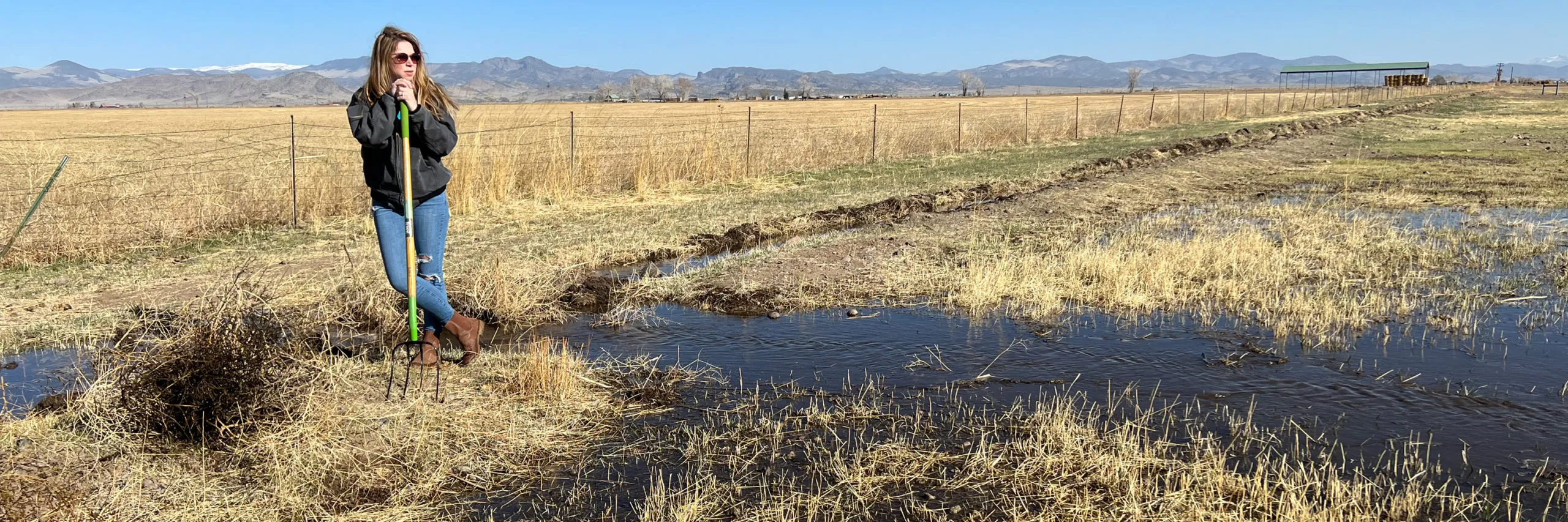
Subdistrict 1 Program Manager Marisa Fricke clears paths for water to flow onto land the subdistrict owns. The property is one of the subdistrict’s investments in recharging the aquifer. Photo credit: The Alamosa Citizen
Click the link to read the article on the Colorado Public Radio website (Michael Elizabeth Sakas). Here’s an excerpt:
Colorado lawmakers unanimously voted to set aside $60 million of federal COVID relief money to create a fund to help water users in two river basins meet groundwater sustainability targets. If signed by Gov. Jared Polis, the legislation would create a groundwater compact compliance and sustainability fund administered by the Colorado Water Conservation Board. The money would be used to buy and retire groundwater wells used to irrigate farmland in the Rio Grande River basin in the south and the Republican River basin in the east to keep the water in underground aquifers that are struggling to keep up with drought and overuse…
Farmers and ranchers in both river basins face rapidly approaching deadlines to reduce their water use, which are necessary to maintain interstate river agreements and preserve underground water supplies. If these goals aren’t met, state water officials say there could be alarming consequences — and thousands of well users could face water cuts.
In the San Luis Valley, the state water engineer is requiring some groundwater well users to limit pumping because too many wells are all pulling from the same groundwater source. Chris Ivers, the program manager for two subdistricts in the Rio Grande Water Conservation District, said farmers and ranchers have levied property taxes on themselves to fund similar local efforts to meet groundwater sustainability goals.
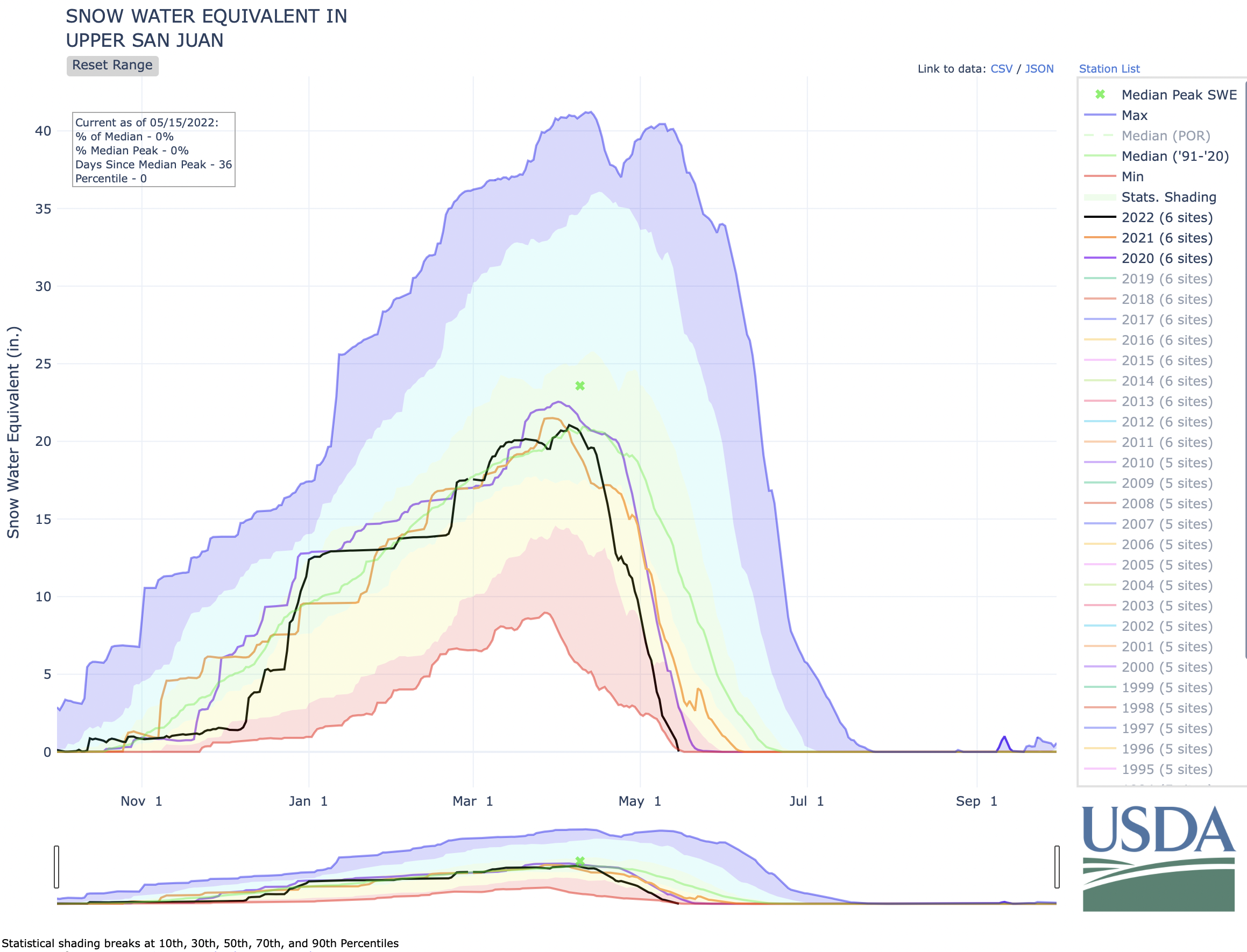
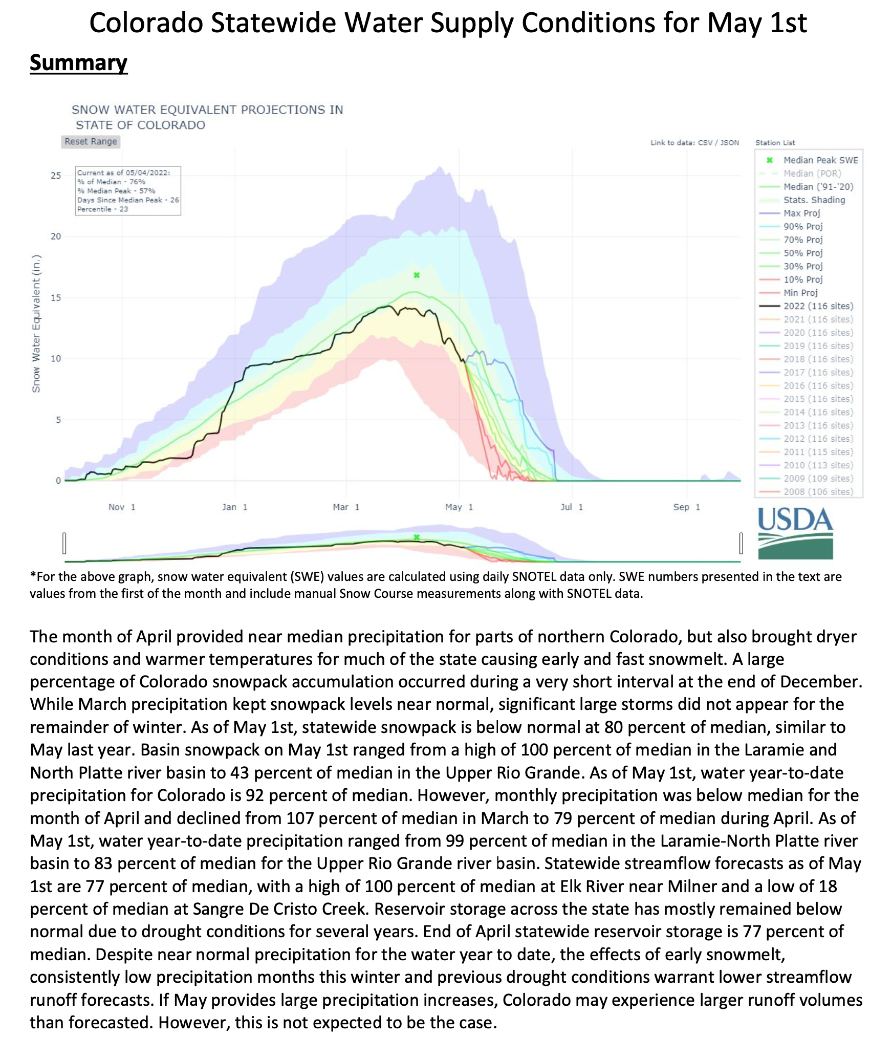
Southern Colorado’s snowpack is already on its last legs, reaching levels for this point in May only seen twice in the past 20 years – 2002 and 2018, which were both marked by large and destructive wildfires and widespread drought. The Upper Rio Grande basin was at just 9% of median levels Thursday compared to the past 30 years – with just 0.6 inches of snow-water equivalent (SWE) remaining, according to U.S. Department of Agriculture data…
The San Miguel, Dolores, Animas and San Juan basin was at 18% of median snowpack levels Thursday, with 1.4 inches of snow-water equivalent remaining. In 2002, the worst year in the basin in terms of snowpack melt since 1991, the snowpack reached that level on April 26…
The Arkansas basin was 35% of median levels compared to the past 30 years as of Thursday, sitting at 2.5 inches of snow-water equivalent, according to the USDA data. This time in 2020, it was at similar levels. In 2018, the basin’s snowpack reached 2.4 inches of SWE on May 7, and in 2002, the worst year over the 30-year period, it reached 2.5 inches SWE on April 16…
The Gunnison basin was at 49% of median snowpack levels Thursday, with 4.3 inches SWE left. The Gunnison basin reached the same levels on May 6, 2018, and April 28, 2002, which was the year the snowpack there was gone the earliest.
The Upper Colorado River basin was at 66% of median snowpack levels as of Thursday…
The snowpack in the northern half of the state is faring better than southern Colorado’s, with the South Platte (76%), Yampa and White (84%) and Laramie and North Platte (92%) basins all above three-quarters of median levels as of Thursday. Statewide, the snowpack was at 64% of median as of Friday.
Colorado River headwaters tributary in Rocky Mountain National Park photo via Greg Hobbs.
Click the link to read the article on The Washington Post website (Karin Brulliard) and for the photos. Here’s an excerpt:
The Colorado River begins as mere streams in a marshy meadow 10,000 feet high in Rocky Mountain National Park. A few miles south, crystal-clear waters burble through the Kawuneeche Valley, its banks flanked in summer by wildflowers, spiky fallen trees and a dusty hiking trail. Small fish flicker over the stony bottom. The river is ankle-deep and narrow, hardly hinting at its outsize role as it twists down mountains, through canyons and across Southwestern deserts. But climate change, population growth, competition and other threats to the entire waterway are also vivid here in the headwaters region.
As temperatures rise, the mountain snowpack that feeds the Colorado river is diminishing over time and melting earlier. That decreasing runoff is more quickly soaking into Western Colorado’s parched terrain and evaporating into its hotter air. Less water is flowing downriver, depriving the ranchers, rafters, anglers and animals who depend on it.
“It feels to me like the future is accelerating really quickly now,” said Andy Mueller, general manager of the Colorado River District, which spans 15 Western Colorado counties. “We’ve been talking to our water users about the impacts of climate change and decreasing supply of water on the river for probably eight or nine years now. It’s really kind of hitting home.”
[…]
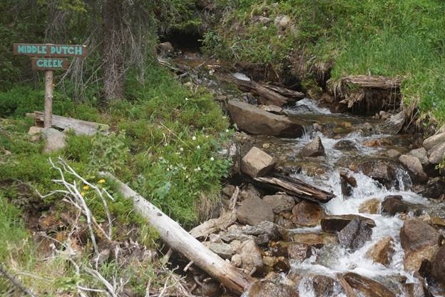
Middle Dutch Creek near the Grand River Ditch. Photo credit Greg Hobbs.
But even before the Colorado lands in the valley, distant demands on its water begin. About 30 percent of the runoff from the nearby Never Summer Mountains, which would naturally flow into the river, is diverted by a channel called the Grand Ditch and delivered to Colorado’s arid and fast-growing east.
It is one of dozens of ditches and tunnels and reservoirs that underlie a common complaint on this side of the Rockies: About 80 percent of Colorado’s precipitation falls here on the Western Slope. About 80 percent of the state’s population lives on the other side — and those residents think too little about where their water comes from, people in the west say.
Colorado transmountain diversions via the State Engineer’s office
Flaming Gorge is clearly a marvel of engineering, from pendulum-like “plumb lines” that help Reclamation employees ensure the 60-year-old concrete structure isn’t moving around too much, to “weep holes” that reduce pressure buildup by allowing water to seep through fissures in the canyon walls on either side of the dam. Electric lines extend upward from the blockish power plant, soaring out of the canyon through a series of transmission towers that send carbon-free energy to the Black Hills, Burbank and beyond…
The Biden administration said this month it would release an extra 500,000 acre-feet of water from Flaming Gorge Reservoir over the next year, as part of a desperate effort to stop Powell from falling so low that Glen Canyon Dam can no longer generate power. That’s on top of the 125,000 acre-feet that Flaming Gorge contributed to Powell in a first-of-its kind series of releases last year…
Hydropower has long been a backbone of the Western power grid, with rivers from the Colorado to the Columbia fueling the growth of cities including Los Angeles, Phoenix and Seattle. And even as some environmental activists campaign to demolish certain dams and restore the ecosystems they destroyed, hydropower turbines have become an increasingly valuable tool for keeping the lights on after sundown, when solar panels stop generating electricity. The threat of power shortages is real — especially on stiflingly hot summer evenings when the entire West is baking, and people have no choice but to keep blasting their air conditioners after sundown. Those are the kinds of conditions that prompted rolling blackouts in California in August 2020, with state officials warning that the potential for outages could be worse this summer.
Wyoming rivers map via Geology.comUtah Rivers map via Geology.com
Stream flow for the San Juan River peaked on May 8 at approximately midnight at 1,970 cubic feet per second (cfs), according to the U.S. Geological Service (USGS) National Water Dashboard. This peak matches almost exactly the timing of last year’s peak flow of 1,280 cfs, which occurred on May 8 at approximately 1 a.m. As of 10:45 a.m. on May 11, the river flow was at 1,360 cfs, down from a nighttime peak of 1,830 cfs at 12:15 a.m.
According to the U.S. Department of Agriculture (USDA) National Water and Climate Center’s snowpack report, the Wolf Creek summit, at 11,000 feet of elevation, had 9.9 inches of snow water equivalent as of noon on Wednesday, May 11. The Wolf Creek summit is at 30 percent of the May 11 snowpack median. The San Miguel, Dolores, Animas and San Juan river basins were at 19 percent of the May 11 median in terms of snowpack.
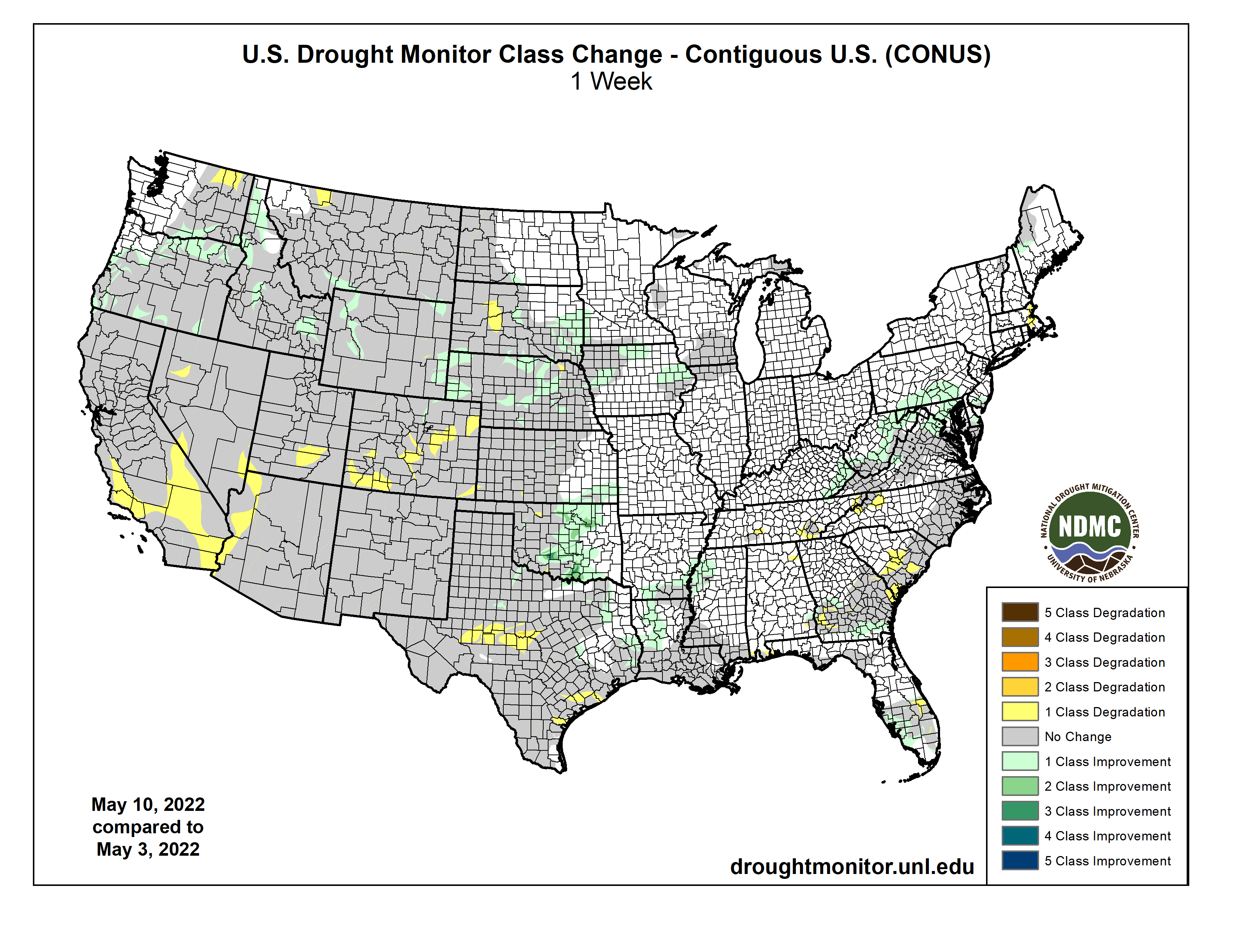
Colorado Drought Monitor map May 10, 2022.
The National Oceanic and Atmospheric Administration’s (NOAA) National Integrated Drought Information System (NIDIS) reports that 100 percent of the county is experiencing drought, with April 2022 being the eighth driest April in 128 years, with 1.22 fewer inches of precipitation than normal, and with 2022 being the 11th driest year in the last 128 years, with 4.15 inches of precipitation below normal. The NIDIS places the entire county in a moderate drought, which the website notes may cause rangeland growth to be stunted, very little hay to be available, dryland crops to suf fer and wildfires to increase. The NIDIS also shows 18.8 percent of the county, primarily on the southern edge, in a severe drought, which may cause farmers to reduce planting, producers to sell cattle and the wildfire season to be ex tended. The NIDIS also notes that a severe drought is associated with low snowpack and surface-water levels and reduced river flow.
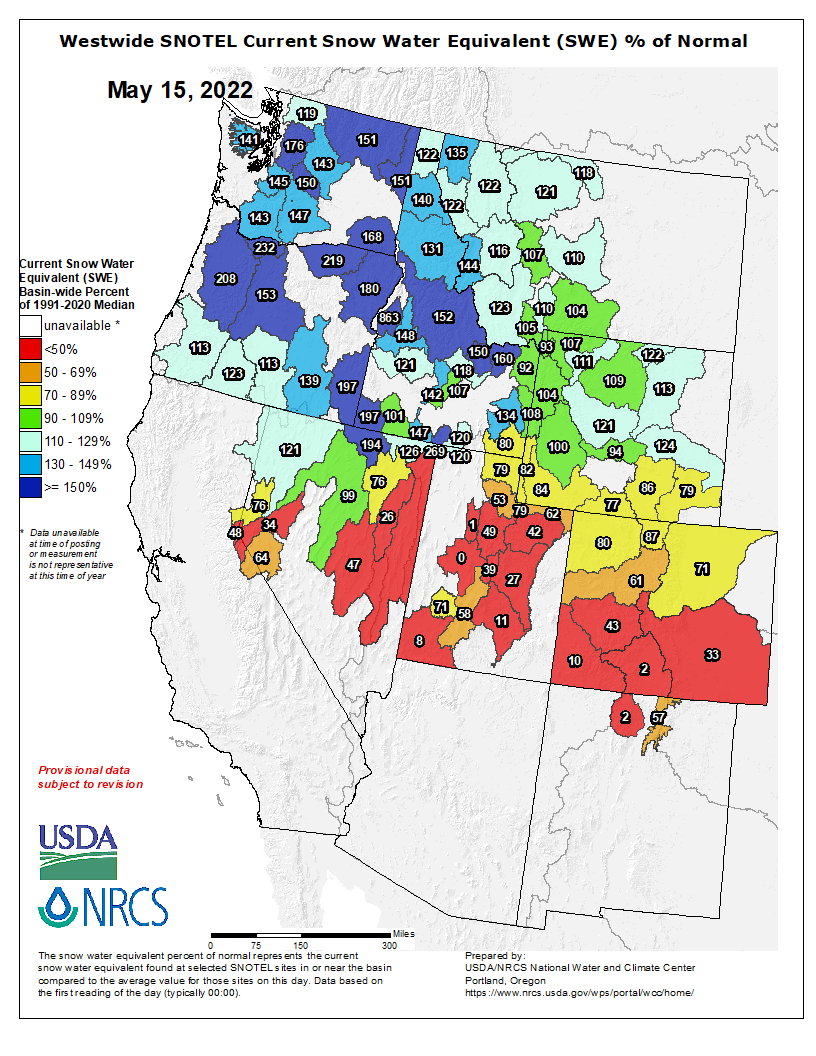
Westwide SNOTEL basin-filled map May 14, 2022 via the NRCS.
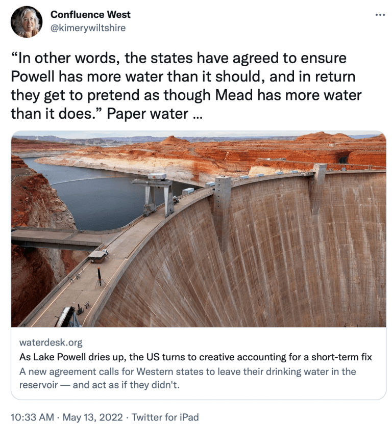
Click the link to read the article on The Water Desk website (Jake Bittle, Grist). Here’s an excerpt:
A new agreement calls for Western states to leave their drinking water in the reservoir — and act as if they didn’t.
Late last week, the states agreed to forfeit their water from Lake Powell in order to ensure that the reservoir can still produce power. The deal puts a finger in the metaphorical dike, postponing an inevitable reckoning with the years-long drought that has parched the Colorado River — and a wrenching tradeoff between power access and water access for millions. It does so, in part, through an unusual act of hydrological accounting.
The deal has two parts. The first and more straightforward part is that the federal government will move 500,000 acre-feet of water (about 162 billion gallons) from the Flaming Gorge Reservoir into Lake Powell, bumping up water levels in the latter body. Flaming Gorge, which stretches across Wyoming and Utah, is mostly used for water recreation, so the immediate effects of the transfer will be minimal. The feds could do more of these water transfers later in the year if things get worse, drawing on water from other nearby reservoirs.
The second part is more complicated — and less helpful. In ordinary circumstances, the Bureau of Reclamation releases water from Lake Powell into an even larger reservoir called Lake Mead, from which it then flows to households and farms across the Southwest. As part of the deal, the states that rely on Mead water are agreeing to leave about 480,000 acre-feet of that water in Lake Powell, thus lowering the water levels in Mead. (Reclamation already announced earlier this year that it would delay the release of 350,000 acre-feet of water in Powell in anticipation of spring snow runoff.)
DOUGLAS County will release a redacted version of an attorney memorandum at the same time it gives its decision on whether to move ahead with a proposal by Renewable Water Resources to transport water from San Luis Valley aquifers to the affluent metro-Denver suburb.
The three county commissioners met for over an hour in a closed-to-the-public executive session Thursday to discuss which portions of water attorney Steve Leonhardt’s analysis and recommendations on the RWR plan would be redacted.
“We will release our decision alongside this redacted memorandum,” said Commissioner Abe Laydon, chair of the board. A disappointed Commissioner Lora Thomas said she was under the impression a redacted version would be released as early as Thursday but now the release will occur at a future board work session.
SLV WATER: Find more coverage of the RWR plan and other Valley water issues HERE
Laydon said a “large majority” of the information contained in Leonhardt’s memorandum to the commissioners would be made public. Redacted would be any information privileged to Renewable Water Resources or any information that would harm Douglas County in any future water discussions. Personal information of individuals Laydon and Leonhardt said they met privately with in the San Luis Valley would also be redacted.
Meanwhile, the SLV Ecosystem Council submitted 255 signatures to the Douglas County commissioners in opposition to the water exportation plan. In the letter, SLV Ecosystem Council Director Chris Canaly slammed the commissioners for canceling a public meeting in the San Luis Valley and for their treatment of water and environmental experts who took time to educate the commissioners on the Valley’s dire water situation.
“… SLV representatives compiled critical research and presented significant facts and valuable findings that embody generations of historical water knowledge of the Rio Grande basin. Your reaction to this good faith effort has been complete dismissal, even disdain.”
HB22-1329: Adds water accounting coordinators in the South Platte River, Arkansas River, and Rio Grande Basins to help maximize the beneficial use of the state’s water resources. #coleg (2/3) #coleg
— CO Dept of Natural Resources (@ColoradoDNR) May 12, 2022
HB22-1379: Includes $20M investment from the Economic Recovery and Relief Cash Fund in order to address the health of our watersheds and forests and to seize on the unprecedented availability of federal funds through the Bipartisan Infrastructure Bill. #coleg (2/4)
— CO Dept of Natural Resources (@ColoradoDNR) May 12, 2022
HB22-1379: Approximately 80 percent of Colorado’s population relies on forested watersheds to deliver water supplies. Healthy forests and watersheds provide critical ecosystem services such as carbon sequestration, water supply, filtration, and purification. #coleg (1/4)
— CO Dept of Natural Resources (@ColoradoDNR) May 12, 2022
SB22-028: The state stands by these communities and their local champions to help reduce the uncertainty for the next generation of farmers and ranchers in Colorado. # coleg (2/2)
— CO Dept of Natural Resources (@ColoradoDNR) May 12, 2022
HB22-1011: $10 million to match dedicated local funding or programs for wildfire mitigation and forest management, incentivizing local investment in wildfire preparedness. #colegpic.twitter.com/pB5ZgOyXis
— CO Dept of Natural Resources (@ColoradoDNR) May 12, 2022
SB22-198: COGCC has established annual fees associated with wells to create a funding mechanism to address Colorado’s Orphan Wells that create transparency for industry to pay to clean up orphan wells, not taxpayers. @ColoradoOGCC#coleg (2/2)
— CO Dept of Natural Resources (@ColoradoDNR) May 12, 2022
HB22-1329: Adds an Assistant Director for Energy Innovation in the Executive Director’s Office to engage proactively and coordinate among DNR divisions and with other state agencies on a wide range of current and emerging energy issues. #coleg
— CO Dept of Natural Resources (@ColoradoDNR) May 12, 2022
Tweetstorm RECAP: This leg session, 15 priority bills passed for @ColoradoDNR to provide critical funding, enhance outdoor recreation, protect our wildlife and water resources, and improve forest health. Thank you @GovofCO & all of our #coleg champions for your support! #coleg
— CO Dept of Natural Resources (@ColoradoDNR) May 12, 2022
Click the link to read “2022 Colorado General Assembly session: Legislators wrap up work after tackling fentanyl, passing largest budget in history” from Colorado Politics (Marianne Goodland, Hannah Metzger, Pat Poblette and Luige Del Puerto) via The Colorado Springs Gazette website. Here’s an excerpt:
Record spending. Legislators passed and the governor signed a $36.4 billion spending plan — the biggest in Colorado’s history — that funds state priorities in the upcoming fiscal year. The budget allocates roughly $2.5 billion more than current spending levels. The budget includes major increases in several areas, notably health care and public safety…
Marshall Fire December 30, 2021. Photo credit: Boulder County
Wildfires. The nature of the Marshall fire, which tore through a suburban neighborhood in the dead of winter, horridly illustrated Colorado’s new reality: a state that could face its worst wildfire season in history…
HB 1132 requires all controlled burns on private property to be reported to local fire departments. SB 7 implements an enhanced wildfire awareness month outreach campaign over the next two years. HB 1011 allocates nearly $27 million to match money that local governments designate for forest management or wildfire mitigation efforts, and HB 1012 spends over $7 million on forest health and restoration. Earlier this session, the legislature also passed HB 1007, which creates a grant program funding wildfire mitigation outreach; HB 1111, which increases insurance coverage of wildfire losses and SB 2, which spends $5 million on volunteer firefighting resources.
Click the link to read the article on the KUNM website (Emma Gibson):
As climate change shifts the norms of water management, a company is mapping the West to collect more accurate snow depth data. Airborne Snow Observatories flies planes over watersheds and beams hundreds of thousands of laser pulses each second to the snowpack below using a laser scanner or airborne lidar system. They’re creating elevation maps that aid in calculating snow depth and the water supply forecast across the West…ASO co-founder Jeffrey Deems says by comparing these maps to ones done in the summer, they can calculate the snow’s depth throughout the whole watershed, bringing more precision and scope to water forecasting and management.
“What can you do when you have higher confidence in your snow inventory and therefore your water supply forecast?” Deems said of the possibilities. “Can you start to make more informed decisions earlier in the year? Do you get early warning of floods or droughts within the year that can improve decision making come snowmelt season?”
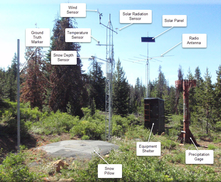
SNOTEL automated data collection site. Credit: NRCS
Conventional methods used by the federal Natural Resources Conservation Service monitor snowpack via SNOTEL stations. A mountain watershed in Colorado could have several of these stations that continuously monitor snowpack weight and estimate the amount of water available when snowpack melts. But this method, Deems says, relies on comparisons to past data and can be less dependable as climate change alters snow accumulation and melt patterns.
“What we’re doing is mapping the snowpack everywhere,” Deems said. “It gives us an accurate snow volume and therefore decouples us from that reliance on the historic record.”
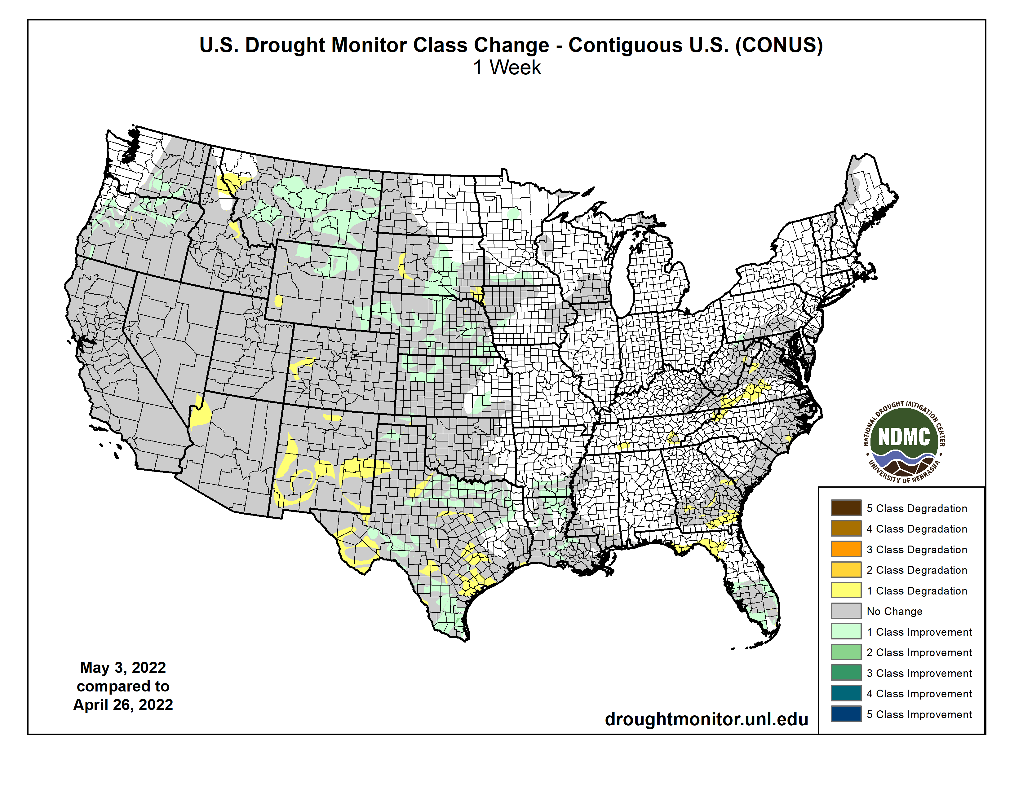
This U.S. Drought Monitor (USDM) week saw continued improvements on the map across the Pacific Northwest and the northern Plains in response to another round of unsettled weather during the past week. In the Pacific Northwest, Northern California, and the northern half of the Intermountain West, a series of disturbances starting last weekend brought cold temperatures and significant snowfall accumulations to the higher elevations of the Cascades, Klamath Mountains, Sierra Nevada, ranges of the northern Great Basin, and the Northern Rockies. Storm totals ranged from 6 to 18+ inches, providing a much-needed boost to mountain snowpack levels. In addition to the late-season snowfall, temperatures plummeted well below normal levels. Minimum temperatures dipped into the teens in the Sierra Nevada as well as across areas of the Intermountain West including Peter Sinks, Utah (Bear River Mountains of northern Utah), which registered the national low of 7 deg F on May 11, according to the National Weather Service Weather Prediction Center. In Northern California, recent storms and cooler temperatures helped to temporarily delay further deterioration of the already shallow snowpack, which was only 22% of normal statewide on May 11. In the Southwest, unseasonably warm, dry, and windy conditions exacerbated fire-weather conditions where nine large fires are currently impacting the region, including the Hermits Peak Fire which has scorched ~204,000 acres (43% contained) in the southern Sangre de Cristo Range, northeast of Santa Fe, New Mexico. In the northern and central Plains, isolated showers, and thunderstorm activity led to continued modest improvements in drought-related conditions. Meanwhile, in the southern Plains and Texas, the first heat wave of the season brought 90 to 110+ deg F temperatures to the region as well as periods of critical fire-weather conditions. In eastern portions of the southern Plains, isolated heavy rainfall accumulations (3 to 8+ inches) helped to ease drought conditions. However, drought-stricken areas of western Kansas and Oklahoma largely missed out on recent storm events. In the Midwest, light to moderate rainfall accumulations (1 to 5 inches) were observed in the southern and western portion of the region this week with most of the region remaining drought-free. In the Mid-Atlantic, rainfall accumulations ranging from 2 to 4 inches across areas of Pennsylvania, Maryland, northern Virginia, and West Virginia boosted area streamflows and helped to improve drought-related conditions on the map. In the Southeast, short-term dryness during the past 30 to 90 days led to minor degradations in the Lower Savannah River Basin along the Georgia-South Carolina border, while another round of isolated storms in southern Florida led to improvements in drought-affected areas…
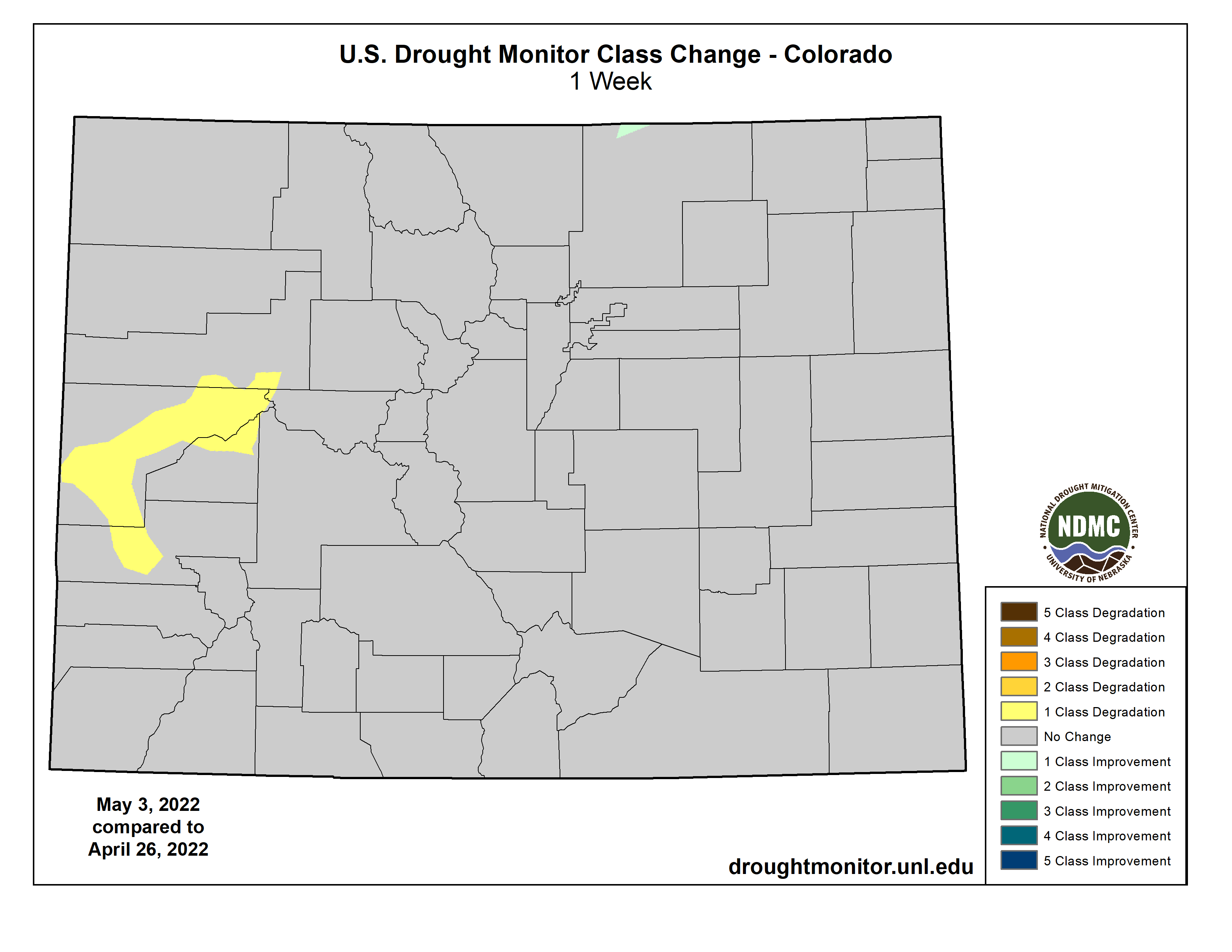
On this week’s map, improvement in drought conditions continued on the map in areas of eastern Kansas, Nebraska and eastern South Dakota where another round of storms helped to alleviate short-term deficits as well as provide a modest boost to soil moisture levels and streamflows. However, the longer-term impacts of the drought in western portions of the region are still causing impacts including areas with poor pasture and rangeland conditions and low stock pond levels. In eastern Colorado, conditions degraded in response to continued dryness over the past several months with reports of little new growth of grasses, blowing sand and dust, and very dry soils as well as crops being abandoned in some areas, according to the Colorado Climate Center. For the week, average temperatures were above normal across most of the region with positive departures ranging from 2 to 8+ deg F and the greatest departures observed in eastern portions of Colorado and Montana. According to NOAA NCEI, North Dakota logged its 2nd wettest (+2.3-inch anomaly) April on record (as evidenced in severe flooding observed in eastern portions of the state). Likewise, precipitation in South Dakota and Montana was also both above normal (32nd wettest) for April. In contrast, April was very dry, with Kansas seeing its 3rd driest and Colorado its 5th driest on record…
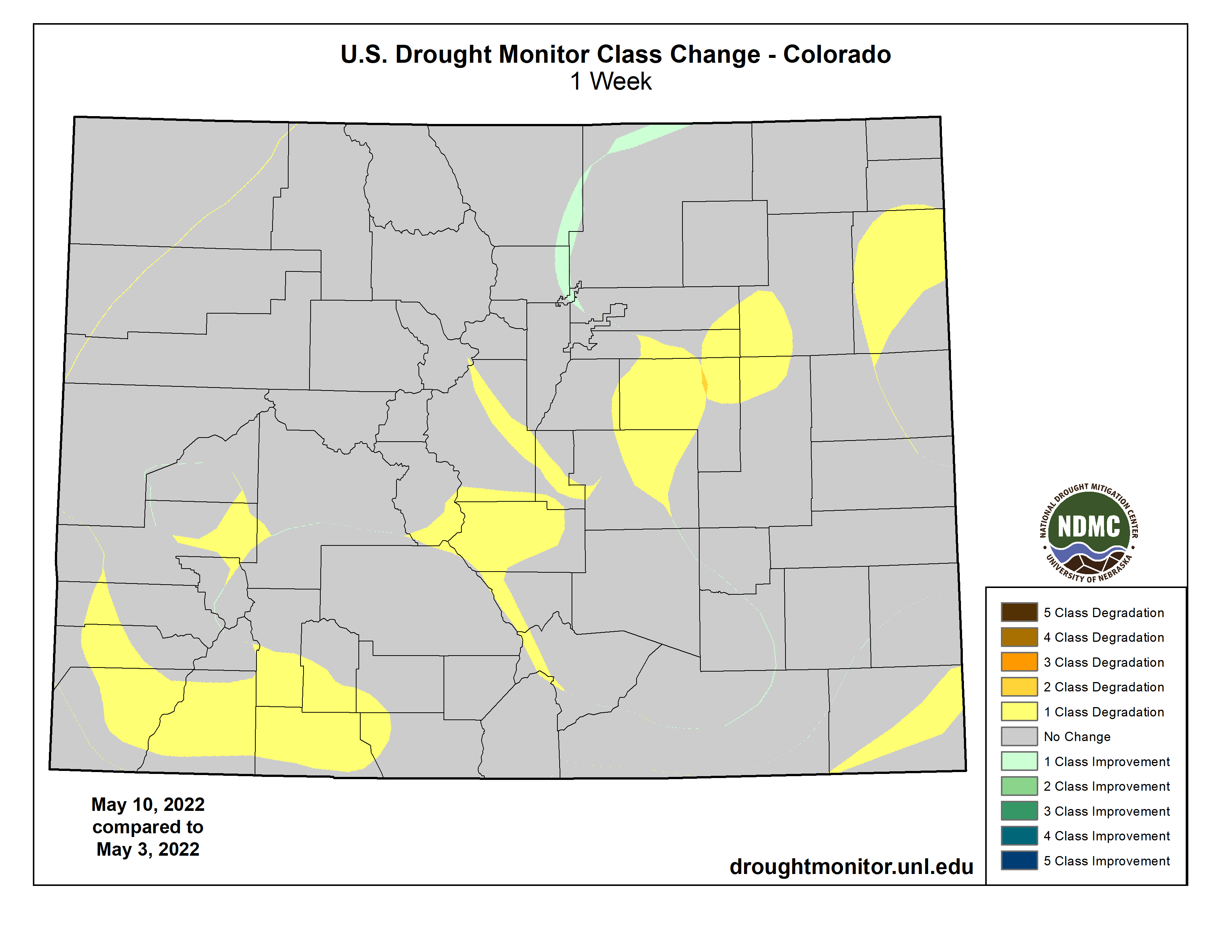
Colorado Drought Monitor one week change map ending May 10, 2022.
Another round of Pacific storms impacted northern portions of the region with beneficial late-season snowfall observed in the Cascades, Klamath Mountains, Sierra Nevada, ranges of the northern Great Basin, and the central and northern Rockies. In response, improvements were made on the map in Oregon, Washington, Idaho, and Montana. In Northern California, precipitation has been above normal during the past 30-day period. However, the recent precipitation did little to make up for significant shortfalls observed since January 1 as well as in the broader longer-term context with 20+ inch precipitation deficits across Northern California during the past 24-month period. According to NOAA NCEI statewide climatological rankings, the January-April 2022 period was the driest (-9.7-inch deficit) on record for California while the last 24-month period (May 2020-April 2022) was the 2nd driest on record. Looking at the latest region-level (2-digit HUC) snowpack data across the West, the NRCS SNOTEL network (May 10) was reporting the following median SWE levels: Pacific Northwest 124%, Missouri 96%, Souris-Red-Rainy 113%, California 68%, Great Basin 61%, Upper Colorado 66%, Arkansas-White-Red 30%, Lower Colorado 10%, and Rio Grande 18%. According to NRCS National Water and Climate Center’s reservoir summary report (May 1), statewide reservoir storage levels remained below normal across all western states with exception of Washington state. In the Colorado River Basin, Lake Powell was at 24% of capacity and Lake Mead 30% of capacity on May 10, according to the USBR. In the Rio Grande Basin, New Mexico’s Elephant Butte Reservoir was 13% full and Caballo Reservoir 10% full. In Arizona, the Salt River system was 76% full while the Verde system was 33% full with the total system at 71% full―down 2% from a year ago, according to the Salt River Project. Looking at region-level climatological rankings, the West Climate Region (California and Nevada) logged its driest January-April period on record while the Southwest Climate Region (4-Corners states) observed their 3rd driest. Longer-term, the May 2020-April 2022 period was the driest on record for the Southwest Climate Region and the 2nd driest for the West Climate Region…
In the South, drought-related conditions improved in eastern Oklahoma and areas of northeastern Texas. In eastern Oklahoma, very heavy rainfall accumulations (ranging from 3 to 8+ inches) led to improvements on the map. However, this week’s heavy rains largely missed the western part of the state. Likewise, much of the western half of Texas was very dry combined with extreme heat, leading to further expansion of areas of Extreme Drought (D3) and Exceptional Drought (D4). Average temperatures across the region were well above normal. The most extreme heat was observed across Texas (6 to 10+ deg F above normal) with high temperatures soaring over 110 deg F in the Trans-Pecos region. Since last Tuesday (May 3), Big Bend Village (Big Bend National Park) logged the national high temperature six out of the seven days, with highs ranging from 102 to 112 deg F. Likewise, the heat wave that impacted much of the region saw temperatures rise above 100 deg in the southern Plains. The excessive heat this week continued to dry out already parched soils across much of Texas as well as in western Oklahoma where negative soil moisture anomalies (20th percentile) showed up on various soil moisture models. Moreover, 7-day streamflows at numerous gaging stations across the Hill Country of Texas and southwestern Oklahoma dipped below the 10th percentile, according to the U.S. Geological Survey. Also notable, Oklahoma saw its windiest April on record (1994-present) statewide, according to the Oklahoma Mesonet. According to NOAA NCEI, average temperatures were above normal across Texas, Oklahoma, and Louisiana with Texas logging its 11th warmest (+4 deg F anomaly) April on record…
Looking Ahead
The NWS WPC 7-Day Quantitative Precipitation Forecast (QPF) calls for moderate-to-heavy liquid (liquid = rain + SWE) precipitation accumulations ranging from 2 to 5+ inches across western portions of Oregon and Washington while lighter accumulations (< 1 inch) are forecasted for areas of the Northern Rockies. The remainder of the West is expected to be dry during the next 7-day period. In northern portions of the High Plains, light to moderate accumulations (generally < 3 inches) are expected while light accumulations (< 1 inch) are forecasted for areas of the Midwest, South, Mid-Atlantic, and the Northeast. The CPC 6-10-day Outlooks calls for a moderate-to-high probability of above-normal temperatures across the lower two-thirds of the conterminous U.S., while below-normal temperatures are expected across the Pacific Northwest and the Upper Midwest. In terms of precipitation, below-normal precipitation is expected across Northern California, much of the Intermountain West and Southwest, South, and the Upper Great Lakes region. Conversely, above-normal precipitation is forecasted for portions of the Pacific Northwest and the northern Plains.
US Drought Monitor one week change map ending May 10, 2022.
There are so many things I find devastating about how Earth breakdown is playing out. All the people, animals, trees, and places that are simply dying. But also, how so many people don't care. Yes, you care, and thank you for that, but far too many don't. I thought more would.
Construction began April 1 on Denver Water’s five-year project to expand Gross Reservoir by raising the height of the dam.
The reservoir and dam, located in the foothills west of Boulder, were named after former Denver Water Chief Engineer Dwight Gross. The dam was completed in 1954 to store water from the West Slope for Denver’s growing population.
The dam was originally designed to be raised in the future when needed.
Now, Denver Water is raising the height of the dam by 131 feet to help ease a storage imbalance in the utilities’ water collection system. Once completed, Gross will be the tallest dam in Colorado.
The dam was originally designed to be raised in the future when needed. Now, Denver Water is raising the height of the dam by 131 feet to help ease a storage imbalance in the utilities’ water collection system. Once completed, Gross will be the tallest dam in Colorado.
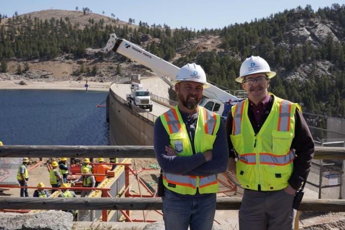
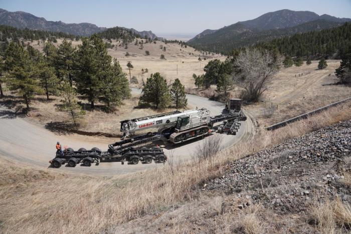
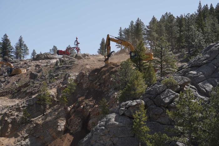
“We’ve been busy bringing trucks, cranes and other heavy equipment to the site to prepare for construction,” said Doug Raitt, construction manager of the Gross Reservoir Expansion Project for Denver Water. “A lot has to be done just to prepare the site for all the work that has to happen.”
Crews navigate a winding road near the dam to bring a large crane to the construction site. Photo credit: Denver Water.
Early work involves blasting rock on the sides of the canyon to make way for the additional concrete that will be placed over the downstream face and above the existing dam.
A machine drills holes into the rock above the dam to place explosives for blasting operations. Photo credit: Denver Water.
Crews also are building a walkway on the upstream side, or reservoir side, of the dam to provide access for workers to walk from one side of the dam to the other.
Upcoming work includes hydroblasting 2 to 3 inches of concrete from the face of the dam so the new concrete will adhere to it. Part of the dam’s spillway will also be removed to prepare for the addition.
Early work involves installing walkways on the upstream side, or reservoir side, of the dam. The walkways are needed because the top of the dam will be removed to make way for the addition. Photo credit: Denver Water.
To raise the dam, crews will start at the bottom and extend the base of the dam out. Then they will build a series of steps up to the dam’s new height — similar to what you see on the sides of an Egyptian pyramid.
The Gross Reservoir Expansion Project involves raising the height of the existing dam by 131 feet. The dam will be built out and will have “steps” made of roller-compacted concrete to reach the new height. Image credit: Denver Water
“When it’s done, it will be the largest dam in Colorado and nearly triple the storage capacity of the existing reservoir,” said Jeff Martin, manager of the Gross Reservoir Expansion Project for Denver Water. “We’re really excited to begin construction on this important project.”
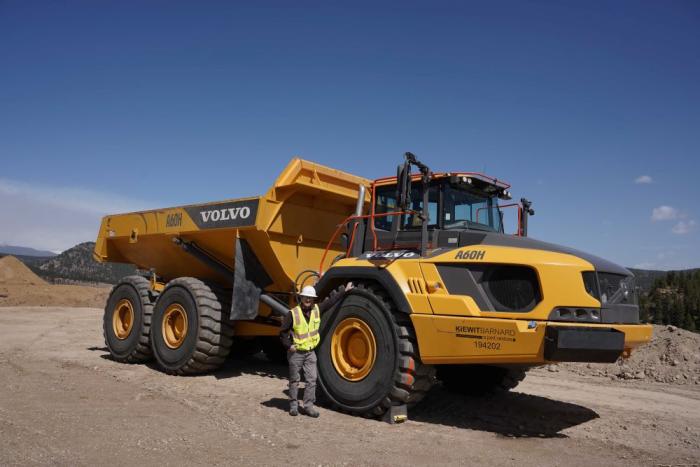
Doug Raitt, construction project manager for Denver Water, stands next to a 60-ton dump truck at the construction site on April 20, 2022. Photo credit: Denver Water.
Martin said that work conducted during 2022 and 2023 will be mostly site preparation for the on-site concrete production and foundation work on the rock on the sides of the dam and around the bottom.
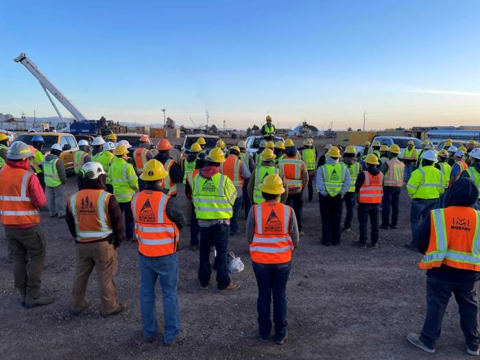
At the height of construction there may be as many as 400 workers on site at a time, Raitt said.
“Raising a dam is often trickier than simply building a new one,” Raitt said. “We have to continue sending water through the dam during construction while transforming the dam into a new structure.”
Crews remove rock that has been blasted away on the north side of the dam. The area near the red machine at the top of the picture will be the new crest of the dam. Photo credit: Denver Water.
Throughout the project, safety will be the No. 1 priority at the site.
“Denver Water and our construction partners have an emphasis on safety for the public and our workers every day,” Raitt said. “We all go through safety training and will continue to evaluate our operations throughout the project.”
Workers take part in safety training with Kiewit-Barnard, the general contractor for the expansion project in April. At the peak of construction, up to 400 workers will be on-site at the dam during the day. Photo credit: Denver Water.
Protecting the environment and wildlife is another important part of the project. Denver Water worked with biologists to make sure there were no bird nests in the area before the start of construction and will continue to do so throughout the project.
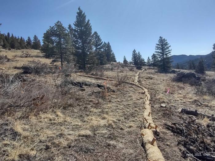
Additional environmental mitigation efforts were put in place to protect South Boulder Creek and the reservoir from sediment and erosion washing in during the work. These efforts will continue throughout the project.
Erosion control measures are put up around construction areas to protect dirt and rocks from falling or washing into South Boulder Creek and Gross Reservoir. Photo credit: Denver Water.
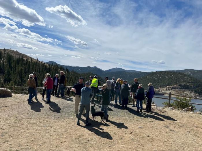
Denver Water also is spending time updating community members around the reservoir.
“It’s important that we let them know what’s happening with the project,” Raitt said.
“For months, we’ve been doing outreach to the community with public meetings, newsletters and emails. We’ve received a lot of feedback from our neighbors letting us know what’s important to them and we’ll continue to work with them and update them throughout the project.”
Denver Water is hosting community meetings with residents who live around Gross Reservoir to update them on the project and answer questions. Photo credit: Denver Water.
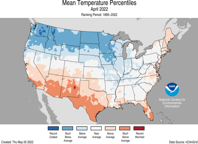
The average temperature of the contiguous U.S. in April was 50.7°F, which is 0.4°F below average, ranking in the middle third of the 128-year record. Generally, temperatures from the Northwest to the Great Lakes and into the mid-Mississippi Valley were below average, with much of the Southwest, Deep South and portions of the East Coast above average
.
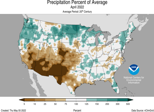
April precipitation for the contiguous U.S. was 2.58 inches, 0.06 inch above average, ranking in the middle third of the historical record. Precipitation was above average across portions of the Northwest, northern Rockies and Plains, Great Lakes and Northeast and below average across the Southwest as well as the central and southern Plains.
Two late-season winter storms brought blizzard conditions to the Northern Rockies and Plains during April with reports of 1-2 feet of snow and drifts of 4-8 feet from Montana to the Dakotas. A late season nor’easter brought more than a foot of snow to portions of the Northeast in mid-April.
Dry and windy conditions across the Southwest and Plains contributed to an active start to the wildfire season. As of May 3, the largest fire across the U.S., the Hermits Peak Fire in New Mexico, consumed more than 145,000 acres and was 20% contained. Across all 50 states, 1.1 million acres have burned from January 1 through May 3 — 160% of average for this time of year.
Several tornado outbreaks occurred during April, contributing to an above-average tornado count for April.
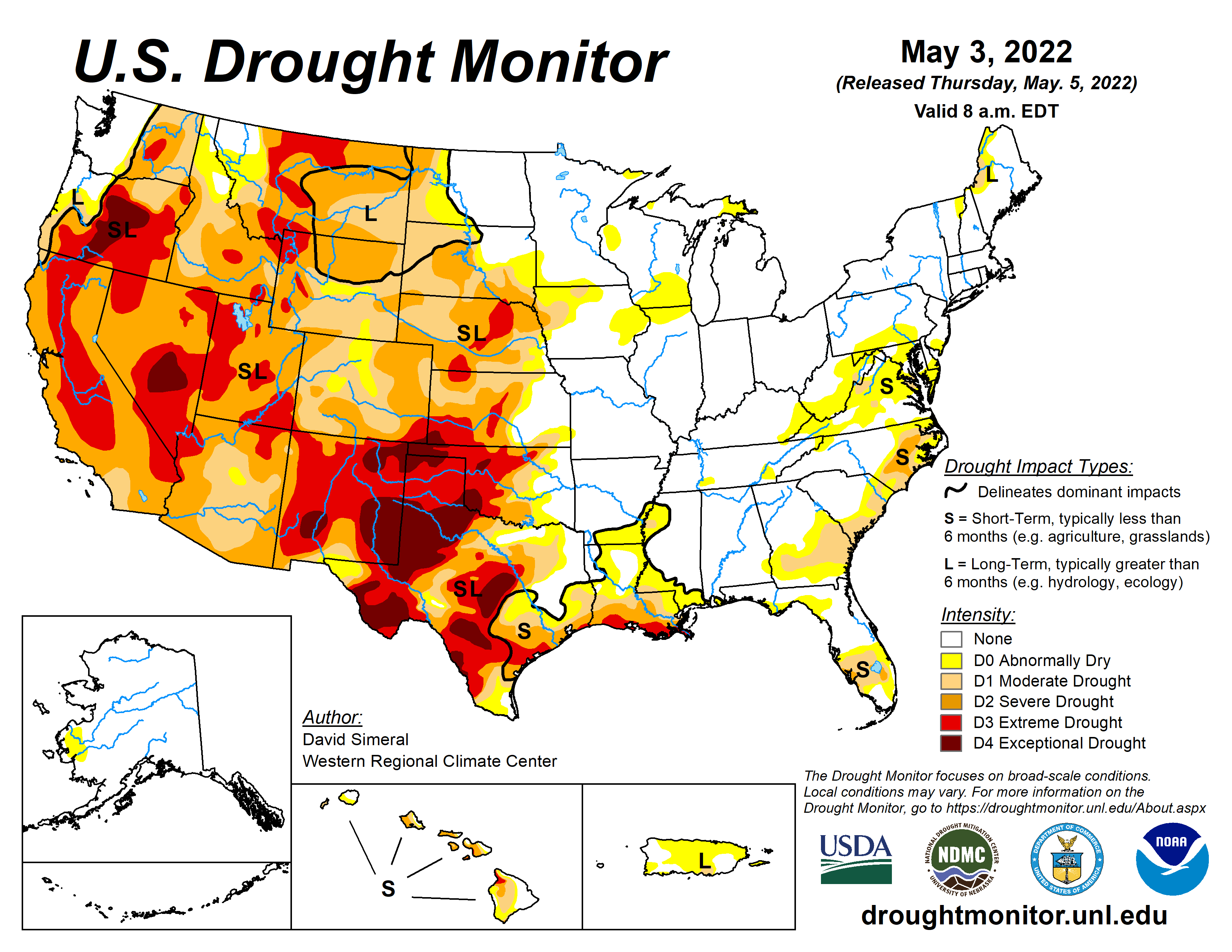
According to the May 3 U.S. Drought Monitor report, 53.8 percent of the contiguous U.S. was in drought. Severe to extreme drought was widespread across the western half of the CONUS and parts of Hawaii.
Other Highlights:
Temperature
Washington state ranked third coldest on record for April while Montana ranked fifth coldest.
The Alaska statewide April temperature was 25.2°F, 1.9°F above the long-term average. This ranked among the middle one-third of the 98-year period of record for the state. Temperatures were below average across much of the Southeast Interior and Panhandle regions and above average across much of the West Coast and Aleutian regions.
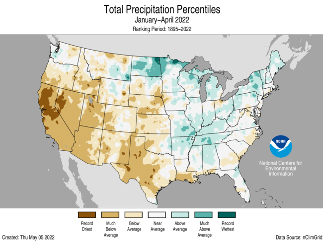
For the January-April period, the average contiguous U.S. temperature was 39.9°F, 0.8°F above average, ranking in the warmest third of the record. Temperatures were above average across parts of the West and also along the East Coast. California ranked sixth warmest on record for this period. Temperatures were below average in parts of the Upper Mississippi Valley and Great Lakes.
The Alaska January-April temperature was 13.5°F, 3.3°F above the long-term average, ranking in the warmest third of the record for the state. Above-average temperatures were observed across much of the western and southern half of the state with the warmest departures from average occurring in portions of south-central Alaska.
Precipitation
Multiple late-season snow events contributed to a wet April for North Dakota, which reported its second wettest such month on record. Oregon and Minnesota ranked seventh wettest. In contrast, New Mexico had its second-driest April on record and Kansas ranked third driest.
April is climatologically one of the driest months of the year across Alaska. Even so, the state of Alaska, as a whole, ranked as the fourth-driest April in the 98-year record. All regions other than the North Slope received below-average precipitation for the month.
he January-April precipitation total for the contiguous U.S. was 8.25 inches, 1.22 inches below average, ranking 13th driest on record. Precipitation was above average across parts of the northern Plains, Great Lakes, mid-Mississippi Valley and the Northeast. Precipitation was below average across much of the West, central Plains and Deep South during the January-April period. California ranked driest on record while Nevada and Utah ranked third driest for this four-month period.
Despite a dry April, precipitation averaged across Alaska for the January-April period ranked eighth wettest and was generally above average from Bristol Bay to the Panhandle with the Central Panhandle region experiencing its wettest January-April on record.
US Drought Monitor map May 3, 2022.
Drought
According to the May 3 U.S. Drought Monitor report, 53.8 percent of the contiguous U.S. was in drought, down about 4 percentage points from the end of March. Drought conditions expanded or intensified across portions of the West, central Plains and Deep South. Drought contracted or was eliminated across portions of the lower Mississippi Valley, the Great Lakes, the Northern Rockies and Plains, and Pacific Northwest, and across portions of Hawaii.
Click the link to read the article on The Land Desk website (Jonathan Thompson) and to drop some dough in the tip jar:
It’s that time of the year, again, folks. Yep, you guessed it, it’s … Yukigata Time! Okay, maybe you didn’t guess it. Maybe you have no idea what the word even means. But I’m willing to bet you are familiar with the concept and, if you are a farmer or a gardener, you probably use a yukigata.
A yukigata is a pattern formed by melting snow on a mountain slope or hillside in the spring. They often serve as agricultural calendars, letting farmers know when to plant certain crops, or when the danger of a tomato-killing freeze has passed. The calendars can be simple: over in the Montezuma Valley gardeners wait until Ute Mountain is free of snow to plant. Or more elaborate: In the Grand Valley of Colorado, it would be foolish to plant before the Swan’s Neck has melted. And in the North Fork Valley of Western Colorado, gardeners wait for the Devil’s Neck on Mt. Lamborn to “break.”
But the yukigatas have been doing their thing, or disappearing, sooner than in the past, tricking people into planting too early and making their crops vulnerable to the inevitable spring freeze. In Durango, Colorado, for example, gardeners once planted according to when the snow melted off the north face of Smelter Mountain. Now that can happen as soon as March—if there’s snow on the mountain at all—which is just too early.
This also messes with plants’ internal calendars, tricking fruit trees into blossoming too early. A study published this spring found wildflowers in the sagebrush ecosystem now bloom weeks earlier than they did in the 1970s. And here’s a cool map from the National Phenology Network showing where trees leafed out earlier (or later) than usual this year.
Clearly the premature melting of the yukigata is caused by less snow to begin with combined with warming temperatures. Dust on the snow causes it to melt faster, too. As does, wait for it, atmospheric thirst! That’s right, the increasing temperatures are making the atmosphere thirstier, and it’s guzzling up snow, drying out plants, sucking up reservoirs, and so on. Last month, scientists from the Desert Research Institute published a study tracking changes in evaporative demand and found it is increasing everywhere, especially in the Southwest.
As evaporative demand increases, it pulls more water from the land into the air via evaporation and transpiration from plants (and snow and reservoirs), leaving less in the streams and soil. In the Rio Grande Basin, the authors say, that means crops need 8% to 15% more irrigation now than they did in 1980. They go on to note, “These increases in crop water requirements are coincident with declining runoff ratios on the Rio Grande due to warming temperatures and increased evaporative losses, representing a compounding stress on water supplies.”
The authors conclude:
“These higher evaporative demands mean that, for every drop of precipitation that falls, less water is likely to drain into streams, wetlands, and aquifers across the region. Soils and vegetation spend more time in drier conditions, increasing potential for forest fire, tree mortality, and tree regeneration failure.”
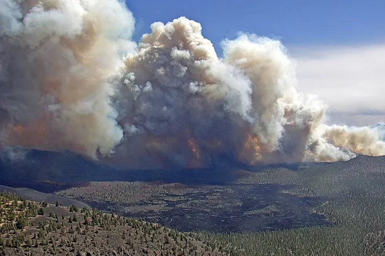
So the thirsty atmosphere is likely a factor in the catastrophic fires currently burning in New Mexico. The Hermits Peak Fire—in the Pecos River watershed, east of the Rio Grande—has grown to a monstrous 166,000 acres and is threatening Las Vegas, Mora, and Montezuma.
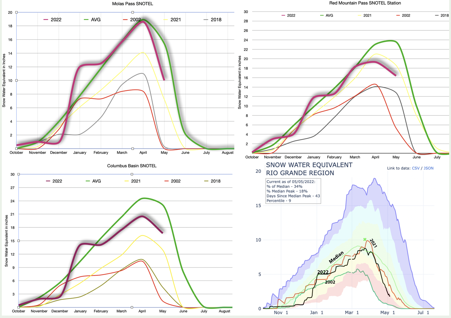
This year neither the Rio Grande nor the Pecos watershed has done all that well, snowpack-wise. Not many watersheds have, although Southwest Colorado is in better shape than it was last year. Snow season is pretty much over. That doesn’t mean it won’t snow any more in the high country. It’s just that the snowpack peak has almost certainly passed, runoff is underway, and many lower elevation SNOTEL stations are registering zero, which can throw off basin-wide graphs. So, below we offer the snowpack season finale with May 1 readings at our three go-to high country SNOTEL , plus the current graph for the Rio Grande Basin.
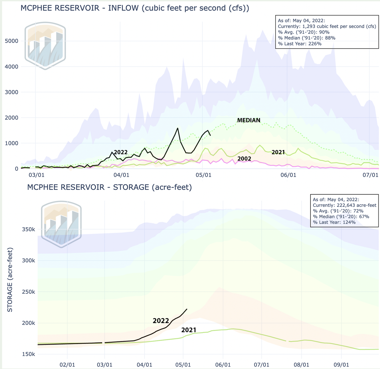
The bright spot is definitely Columbus Basin, high in the La Plata Mountains. It’s below the average level for the period of record, but still doing far better than 2021. The La Platas feed the Animas, La Plata, Mancos, and Dolores Rivers. Last year the Dolores had an awful year. Things are looking up this time around—relatively speaking. The Dolores River through its namesake town shot up to 1,800 cfs at one point, dropped, then shot back up again, pushing up levels at McPhee significantly. Still, don’t goo excited. McPhee’s only at 59% of capacity and water managers are releasing virtually nothing from the dam.
River runners better get out on the water now, while they still can.
Cliffs tower over Flaming Gorge Reservoir in Utah. (RJ Pieper)
Click the link to read the article on the WyoFile website (Dustin Bleizeffer):
The U.S. Bureau of Reclamation will release an extra 500,000 acre feet of water from Flaming Gorge Reservoir to help maintain hydroelectric generation at Lake Powell’s Glen Canyon Dam amid drought conditions that have parched the West for more than two decades.
The action will draw down Flaming Gorge Reservoir’s surface about 10 feet by August and possibly a total of 15 feet later in the fall, according to the BOR. News of the Flaming Gorge release follows calls on two other river systems in Wyoming in April. Those actions were also prompted by “supply side” water shortages due to persisting drought and lower snowpack.
Flaming Gorge Reservoir, on the Green River, straddles the Wyoming-Utah border south of Rock Springs. The Flaming Gorge dam, on the Utah side, was completed in 1964 and is a critical component of the Colorado River water storage system. The Green River, the chief tributary to the Colorado River, originates in the Wind River Range, flows to Flaming Gorge Reservoir, then connects with the Colorado River in Canyonlands National Park in Utah.
Flaming Gorge Reservoir, on the Green River, straddles the Wyoming-Utah border south of Rock Springs. The Flaming Gorge dam, on the Utah side, was completed in 1964 and is a critical component of the Colorado River water storage system. The Green River, the chief tributary to the Colorado River, originates in the Wind River Range, flows to Flaming Gorge Reservoir, then connects with the Colorado River in Canyonlands National Park in Utah.
Flaming Gorge Reservoir, the largest in Wyoming with a storage capacity of nearly 3.8 million acre feet of water, is well-suited to provide extra flows to help address supply shortages on the Colorado River, according to former Wyoming State Engineer Patrick Tyrrell, who represents Wyoming on the Upper Colorado River Commission.
“There will be no additional regulation for municipalities or irrigators or industry in the Wyoming part of the [Colorado River] basin because of what’s going on at Flaming Gorge,” Tyrrell said. “However, we have to be vigilant.”
‘Unprecedented’ conservation measures
The release from Flaming Gorge is part of an “unprecedented” water conservation effort on the Colorado River, which serves tens of millions of people in the American southwest and northern Mexico.
In addition to the release from Flaming Gorge, the BOR will withhold 480,000 acre feet of water in Lake Powell, while Colorado River Lower Basin users have agreed to increased water conservation measures. The Upper Colorado Basin 2022 Drought Response Operations Plan will remain in effect until early 2023.
“We have never taken this step before in the Colorado River Basin,” Interior Department Assistant Secretary Tanya Trujillo said during a press call on Tuesday. “The conditions we see today, and the potential risks we see on the horizon, demands that we take prompt action.”
Flaming Gorge Reservoir on the Utah side near the dam in September 2021. (Dustin Bleizeffer/WyoFile)
The surface elevation at Lake Powell recently fell to 3,522 feet, the lowest since construction of the Glen Canyon Dam in the 1960s. Water intake ducts at the dam’s hydroelectric power station would no longer function if the lake’s surface level reaches 3,490 feet, according to the BOR.
The rebalancing of water supplies between the Upper Basin — which includes Wyoming — and Lower Basin stakeholders is necessary to ensure hydroelectric generation and water supply for the LeChee Chapter of the Navajo Nation and the city of Page, Ariz., the BOR said. Stakeholders in all seven Colorado River Basin states, along with partners in Mexico, agreed to BOR’s conservation actions for this year through a process spelled out in the Colorado River 2019 Drought Contingency Plan.
Although the BOR’s authority over the Colorado River water storage system didn’t require Wyoming’s approval for the drought contingency actions, Wyoming supports the effort, said Tyrrell, adding that it is also in the state’s interest.
“We can’t sit by and just keep [Flaming] Gorge full while everybody else below us is drying up,” Tyrrell said. “Protecting the power pool Lake Powell is really an ultimate goal for all of us — from compact compliance, to the power grid, to funding for reclamation, to environmental programs. Lake Powell is a very key component in that river.”
The Highway 191 Cart Creek Bridge spans Flaming Gorge Reservoir in Utah. (RJ Pieper)
While snow water equivalent, aka snowpack, feeding the basins north of Glenwood Springs is 8% below average, Langhorst said the city’s main water sources — Grizzly and No Name creeks — provide more than enough water to meet the city’s needs, even in the dry years. The first of two primary water sources, Grizzly Creek basin’s lowest snowpack was recorded in 1977, yet the basin still produced more than 4,000 acre feet of water that year. Glenwood Springs uses about 2,200 acre feet of water annually, Langhorst said. Before pulling from Grizzly Creek, however, the city relies on No Name Creek, but no monitors are in place to monitor snowpack feeding the source…
The Grizzly Creek Fire jumped Grizzly Creek north of Glenwood Canyon. (Provided by the City of Glenwood Springs)
Ample water supply, however, doesn’t mean water restrictions are off the table. Langhorst said the city’s watering restrictions in recent years were implemented to facilitate repairs to water plant infrastructure and accommodate for historic spikes of sediment flowing into the system as a result of debris flows. To alleviate stress on the system and lessen the likelihood of future restrictions, the city invested about $8.5 million in water infrastructure upgrades in anticipation to and as a result of the debris flows. Following the infrastructure upgrades, the city can treat about 8.5 million gallons a day and store up to 6 million gallons.
On the hottest days, the city typically uses up to 4.5 million gallons a day.
Water court referee S. Gregg Stanway approved a conditional water right for the city of Ouray that will provide 1.1111 cubic feet per second of water from Canyon Creek to the ice park, as well as Ouray Silver Mines’ request to effectively convey its conditional recreational water right to the ice park, providing an additional 3.34 cfs of water. District Court Judge J. Steven Patrick confirmed Stanway’s rulings. The granting of the conditional water rights was the lynchpin in an arrangement among the city, the mine and the ice park. The mine agreed to lease to the city a portion of its water rights that are currently decreed to the Revenue-Virginius Mine, with the city paying $1 a year for the lease for a 10-year term that can be renewed. The ice park will manage the lease…
Ice park managers had initially planned to build a 3-mile water line along County Road 361 and use the city’s water rights to obtain water from Weehawken Creek. But that project carried a $3 million price tag and a lengthy timeline for completion, given that the pipeline would have crossed U.S. Forest Service and private land.
Instead, mine officials proposed donating the conditional recreational water right to the park, noting the mine wasn’t using that water. The mine has access to close to another 3 cfs as part of its water right. Water will be pumped out of Canyon Creek into the park. The revised project is expected to cost around $1 million. The ice park currently uses about 350 gallons a minute to create ice in the Uncompahgre Gorge. The water right from the mine will provide three or four times that amount. And more water should allow for the creation of another 25 to 40 climbing routes, joining the roughly 150 routes that already exist in the park.
“We’ll have more than enough water now,” Ice Park Executive Director Peter O’Neil said Tuesday. “The biggest issue is making sure we have cold enough temperatures, but when we do, we’ll be able to make ice like a maniac.”
Graphic credit Xylem US.
With the water rights in hand, the plan now is for the mine to hire a contractor to drill a well in Canyon Creek just upstream from the confluence with the Uncompahgre River and install a vertical turbine pump in the bottom of the creek. Water can then be pumped into the gorge and the pipeline in the park. O’Neil said the timing of the pump installation depends on flows in Canyon Creek. He’s hoping to do it either late this spring or early in the fall. The goal is to have the project finished in time for park employees to start farming ice using the new system in the fall of 2022.
Click the link to read the article on the NASA website:
As another winter ends with the U.S. West still in the grip of the worst megadrought in 1,200 years, scientists and water managers are looking at the state of the snowpack. Mountain snowpack is a natural reservoir: As it melts out over the course of the spring and summer, it provides a steady supply of water for millions of people who rely upon it for agriculture, industry, and municipal and residential use.
To forecast water supplies for the coming year, hydrologists and water managers rely on measurements of snowpack, particularly the snow water equivalent (SWE), a measure of how much liquid water is stored within snow. In the western U.S., snowpacks usually peak around April 1. Assessment of the snowpack on this date has traditionally been used to help predict streamflows, reservoir storage levels, and potential wildfire conditions for the rest of the year.
This year, with drought-related moisture deficits in the soil and atmosphere, researchers are seeing widespread and severe low-snow and low-runoff conditions across the West, said Benjamin Hatchett, a hydroclimatologist at the Desert Research Institute who studies snow droughts. “Usually, some regions will be bad, some will be doing okay, and others will be doing great,” Hatchett noted. “But when everywhere [in the West] is in this low-snow condition, it’s pretty concerning.”
While satellites can show where snow is, they cannot yet directly measure snow depth or snow water equivalents. Measurements of snow have been made manually since the early 1900s. In the late 1970s, automated ground-based monitoring began with the SNOTEL network, which is managed by the Department of Agriculture’s Natural Resources Conservation Service. The network is composed of more than 900 monitoring stations placed in remote, high-elevation watersheds in the western U.S., where automated instruments measure snowpack, precipitation, temperature, and other climate conditions.
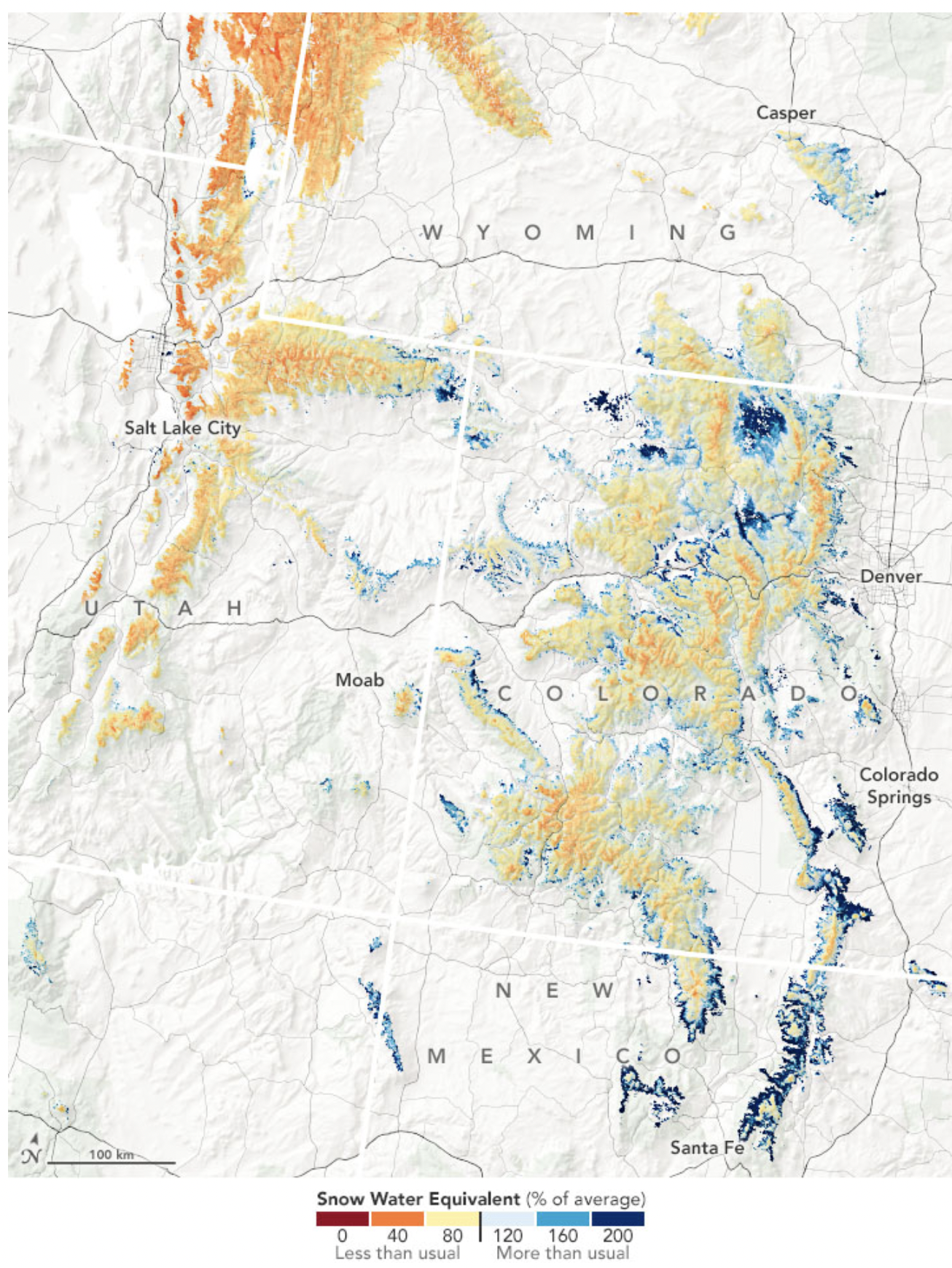
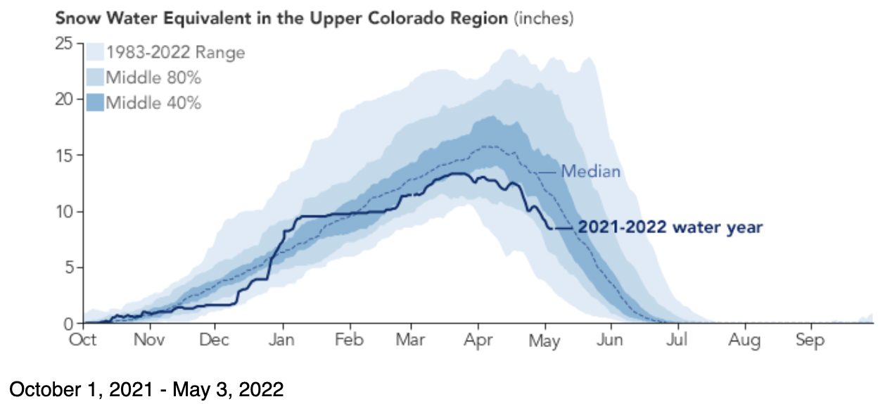
The graph above compares this water-year’s SWE (solid line) to the 1983–2022 median (dashed line) based on SNOTEL data for the Upper Colorado Basin above Lake Powell. The median peak for the entire data record is 15.7 inches—meaning half of the years had peak values above 15.7 inches and half had peaks below it. Peak SWE in this region has typically been reached between April 3–7. This year, the peak SWE of 13.3 inches was reached on March 18 and persisted until March 24, after which it started to decline.
SNOTEL stations record data at a single point location, mostly within a narrow high-elevation range. To estimate the snowpack between and beyond the stations—such as higher elevations and wider geographic areas—researchers must extrapolate and interpolate.
Researchers at the Institute of Arctic and Alpine Research (INSTAAR) at the University of Colorado (CU) Boulder are looking to satellite data to improve those estimates of snow water equivalent. Noah Molotch, an INSTAAR hydrologist with a joint appointment at NASA’s Jet Propulsion Laboratory, and CU-Boulder colleague Leanne Lestak have been using 20 years of satellite data of snow-covered area, along with the SNOTEL data, to generate close to real-time estimates of SWE for use by the U.S. Bureau of Reclamation. Their modeling effort can fill the gaps that ground monitoring doesn’t cover, particularly at certain elevations.
The map at the top of the page shows SWE in the Rocky Mountain region on April 1, 2022, as modeled by the INSTAAR team and compared to the long-term average. The same area is shown below on April 7, 2022, in a natural-color image acquired by the Visible Infrared Imaging Radiometer Suite (VIIRS) on the NOAA-NASA Suomi NPP satellite.
April 7, 2022. Map credit: NASA
Despite some pockets of anomalously high SWE, most areas range from 46 to 95 percent of the 2000–2020 average. Data on the snow-covered area come from Moderate Resolution Imaging Spectroradiometer (MODIS) on NASA’s Terra satellite. The model also accounts for variables such as elevation, slope, latitude, and upwind mountain barriers, as well as historical patterns of SWE and melting dates.
“Water managers really like to see how much snow there is and what the percentage average is at different elevation bands,” said Molotch. “That’s where actually the spatial product is really valuable. Water managers know that snow from low elevations will run off earlier and increase stream flow early in the season, whereas higher elevations run off later and will be the primary source of streamflow later.”
In an April 18 report issued by the Colorado Basin River Forecast Center, forecasters predicted a near-average to much-below average water supply volume for April to July 2022 across the Upper Colorado River Basin and Great Basin.
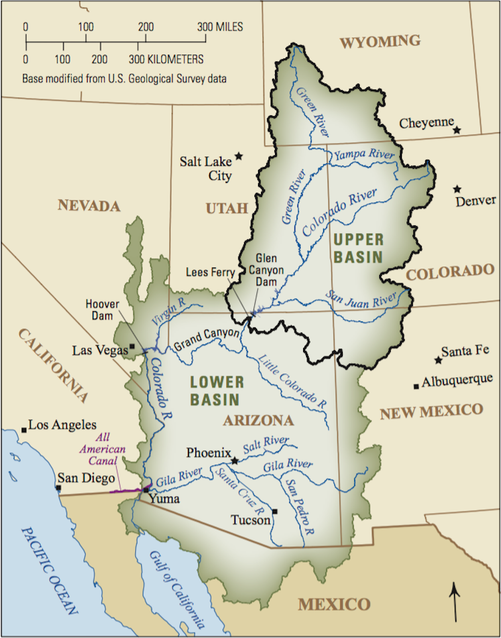
The Colorado River basin covers an area of 246,000 square miles (637,000 square kilometers). This drainage supplies water to tens of millions of people, including those in large urban areas outside the basin, like Denver, Salt Lake City, and Los Angeles, who receive water through diversion projects like tunnels and canals. When snow melts and the water makes it to the Colorado River, it is collected and stored in Lake Mead behind Hoover Dam and in Lake Powell behind Glen Canyon Dam. Hydropower generated at Glen Canyon alone provides electricity to about 5 million people in seven states.
Lake Powell has dropped to its lowest level since the reservoir was first filled in the 1960s. Water behind the dam stands at 3,522 feet above sea level or 24 percent of capacity. If the water drops to a critical level of 3,490 feet, the dam’s ability to produce hydropower will be threatened. On May 3, the U.S. Bureau of Reclamation announced that it will take action to maintain critical hydropower-generating capacity at Lake Powell. Over the next 12 months, the agency will allow more water to flow into the lake from upstream reservoirs and less water to be released downstream.
NASA Earth Observatory images by Joshua Stevens and Lauren Dauphin, using data courtesy of Leanne Lestak/University of Colorado-INSTAAR, the USDA Natural Resources Conservation Service, and VIIRS data from NASA EOSDIS LANCE, GIBS/Worldview, and the Suomi National Polar-orbiting Partnership. Story by Sara E. Pratt.
Students in Palisade High School’s fish hatchery program released the fish at Riverbend Park on Wednesday, the culmination of a full school year of taking care of the fish until they were ready to live in the river.
Some students, as well as Palisade teacher and fish hatchery coordinator Patrick Steele, even planted farewell kisses on some of the Razorback Suckers before releasing them into their permanent home…
At the beginning of the school year, U.S. Fish and Wildlife Service Fish Culturist Mike Gross, also the information and education coordinator with Upper Colorado River Endangered Fish Recovery Program, brings the razorback suckers to the school, where students care for the fish under Steele’s guidance…
Because razorback suckers are on the Endangered Species List, by law, the Colorado River District and the Upper Colorado River District have to allow a certain amount of water to flow through the river in order to create enough space for these fish to live in a new habitat safely.
“That helps water flow downriver, keeping it out of reservoirs and things like that, being able to then keep our canals full to irrigate and so forth,” Steele said. “It really is a great partnership between our U.S. Fish and Wildlife Service and the fish recovery program they run, our irrigation district, our cultural groups and farmers. It’s pretty neat that all those entities need to get together to keep these endangered species rolling and fish flowing through our river.”
The Western U.S. is in a water crisis, from California to Nebraska. An ongoing drought is predicted to last at least through July 2022. Recent research suggests that these conditions may be better labeled aridification – meaning that warming and drying are long-term trends.
On the Colorado River, the country’s two largest reservoirs – Lake Powell and Lake Mead – are at their lowest levels in 50 years. This could threaten water supplies for Western states and electricity generation from the massive hydropower turbines embedded in the lakes’ dams. In August 2021 the federal government issued a first-ever water shortage declaration for the Colorado, forcing supply cuts in several states.
My work as head archivist for Colorado State University’s Water Resources Archive gives me a unique perspective on these conflicts. Our collection includes the papers of Delph Carpenter, a lawyer who developed the concept of interstate river compacts and negotiated both the Colorado and South Platte agreements.
Carpenter’s drafts, letters, research and reports show that he believed compacts would reduce litigation, preserve state autonomy and promote the common good. Indeed, many states use them now. Viewing Carpenter’s documents with hindsight, we can see that interstate river compacts were an innovative solution 100 years ago – but were written for a West far different from today.
Water for development
In the early 1900s, there was plenty of water to go around. But there weren’t enough dams, canals or pipelines to store, move or make use of it. Devastating floods in California and Arizona spurred plans for building dams to hold back high river flows.
With the Reclamation Act of 1902, Congress directed the Interior Department to develop infrastructure in the West to supply water for irrigation. As the Reclamation Service, which later became the powerful Bureau of Reclamation, moved forward, it began planning for dams that could also generate hydropower. Low-cost electricity and irrigation water would become important drivers of development in the West.
Carpenter worried that downstream states, building dams for their own needs, would demand water from upstream states. He was especially attuned to this issue as a native of mountainous Colorado, the source of four major rivers – the Platte, the Arkansas, the Rio Grande and the Colorado. Carpenter wanted to see upper basin states “adequately protected before the construction of the structures upon the lower river.”
The Colorado River flows through seven U.S. states and Mexico, ending at the Gulf of California. USGS
Carpenter also knew about interstate water conflicts. In 1916, a group of Nebraska irrigators sued farmers in Colorado for drying up the South Platte River at the state line. Carpenter was already lead counsel for Colorado in Wyoming v. Colorado, a case involving the Laramie River that began in 1911 and would not be resolved until 1922.
Eventually Carpenter persuaded his Colorado clients to resolve their litigation with Nebraska by negotiating a compact to share water from the South Platte. It took seven years of data collection and discussion, but Carpenter believed the agreement would ensure “permanent peace with our neighboring state.”
Or maybe not. Today Nebraska officials want to revive an unfinished canal to pull water from the South Platte in Colorado, citing concerns about Colorado’s numerous planned upstream water projects. With Colorado officials pledging to aggressively defend their state’s water rights, the states could be headed to court.
Portioning out the Colorado
West of the Continental Divide, the Colorado River flows more than 1,400 miles southwest to the Gulf of California in Mexico. Once, its delta was a lush network of lagoons; now the river peters out in the desert because states take so much water out of it upstream.
In 2014, the U.S. and Mexico started collaborating to restore the ecosystems of the Colorado River Delta.
When settlers developed the West, their prevailing attitude was that water reaching the sea was wasted, so people aimed to use it all. California had a bigger population than the other six Colorado River Basin states combined, and Carpenter worried that California’s river use could hinder Colorado under the prior appropriation doctrine, which dictates that the first person to use water acquires a right to use it in the future. With the U.S. Reclamation Service studying the Colorado to find good dam sites, Carpenter also feared that the federal government would take control of river development.
Carpenter studied international treaties as models for river compacts. He knew that U.S. states had a right under Article 1, Section 10 of the U.S. Constitution to make agreements with each other. And he believed that solving water conflicts between states required “statesmanship of the highest order.”
In 1920, officials agreed to try his approach. After the states and the federal government adopted legislation to authorize the process, representatives began meeting as the Colorado River Commission in January 1922, with then-Secretary of Commerce Herbert Hoover as chair. Meeting minutes show that negotiations nearly collapsed several times, but the end goal of rapid river development held them together.
The commissioners reached agreement in 11 months, adopting a final version of the compact in November 1922. It allocated fixed amounts of water – measured in absolute acre-feet, not percentages of the river’s flow – to the upper and lower basins. With water levels in the river declining, this approach has proved to be a major challenge today.
In 2021 the Interior Department declared a water shortage for the Colorado River, triggering supply cuts for Arizona, Nevada and Mexico.
At their meetings, the commissioners discussed both the variability of the river’s flow and their lack of sufficient data for long-term planning. Yet in the final compact they allowed for dividing up surplus water starting in 1963. We know now that they used optimistic flow numbers measured during a particularly wet period.
A hotter, more crowded West
Today the West faces conditions that Carpenter and his peers did not anticipate. In 1922, Hoover imagined that the basin’s population, which totaled about 457,000 in 1915, might quadruple in the future. Today, the Colorado River supplies some 40 million people – more than 20 times Hoover’s projection.
Testifying before Congress in 1926 about the Colorado River Compact, Hoover stated, “If we can provide for equity for the next 40 to 75 years we can trust to the generation after the next to be as intelligent as we are today.” In the face of extreme Western water challenges, it is now up to Westerners to meet – or exceed – that expectation.
Click the link to read the article on the CNN website (Rachel Ramirez and Brandon Miller). Here’s an excerpt:
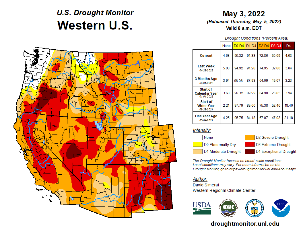
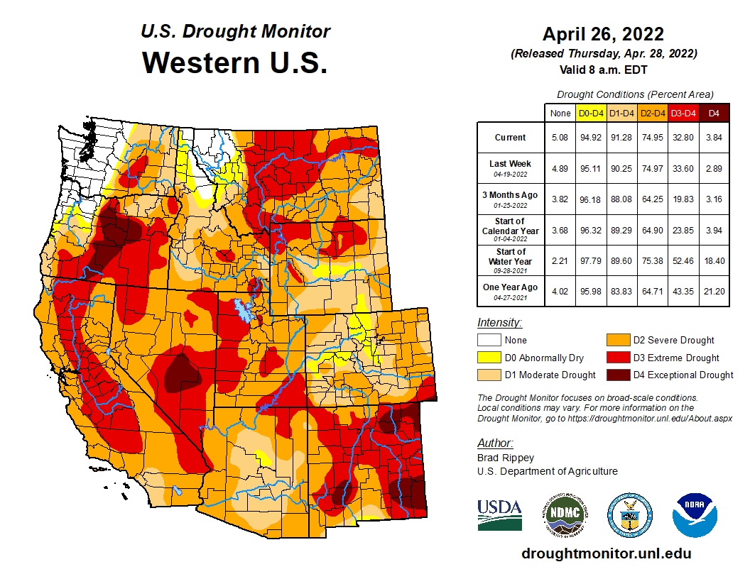
Drought conditions worsened in much of the Southwest over the past week, according to the latest update from the US Drought Monitor, deepening the region’s water crisis and fueling record-setting wildfires across multiple states. More than 98% of the Southwest is in drought this week, according to the monitor, which noted that reservoir storage levels were below-normal in all Western states except for Washington…
US Drought Monitor map May 3, 2022.
The drought-fueled water crisis isn’t limited to California. In the Rio Grande Basin, the Elephant Butte Reservoir in New Mexico is roughly 13% full. In the Colorado River Basin, Lake Powell was at 24% of capacity, while Lake Mead was at 31%, according to US Bureau of Reclamation. On Tuesday, the federal government announced it is taking unprecedented, emergency steps to help boost water levels at Lake Powell…
The dry conditions primed New Mexico’s landscape for the largest fire so far in 2022. The Hermits Peak and Calf Canyon fires — which merged this week — have already burned more than 160,000 acres. That’s more land burned so far in 2022 than in the past two full years combined. The fires prompted the evacuation of thousands of people, with much of the state under a critical fire threat…
Scientists say the West’s historic, multi-year drought is a clear sign of how the climate crisis is affecting not only the weather, but also communities’ water supply, food production, electricity generation and livelihoods. The current conditions is particularly worrisome for many, considering it is only spring season — and summertime heat may worsen conditions. As the planet warms, drought and extreme heat will also fuel deadly wildfires and exacerbate the water crisis.
US Drought Monitor one week change map ending May 3, 2022.
New Mexico and Arizona are facing a dangerously early fire season. It has left neighborhoods in ashes and is having such devastating effects that President Joe Biden issued a disaster declaration for New Mexico. Over 600 fires had broken out in the two states by early May, and large wildfires had burned through hundreds of homes near Ruidoso and Las Vegas, New Mexico, and Flagstaff, Arizona.
We asked wildfire scientist Molly Hunter at the University of Arizona to explain what’s fueling the extreme fire conditions and why risky seasons like this are becoming more common.
Why is this year’s wildfire season in the Southwest so early and intense?
Historically, fire season in the Southwest didn’t ramp up until late May or June, because fuels that carry fires – primarily woody debris, leaf litter and dead grasses – didn’t fully dry out until then.
Now, the Southwest is seeing more fires start much earlier in the year. The earlier fire season is partly due to the warming climate. As temperatures rise, the snow melts more rapidly, more water evaporates into the atmosphere and the grasses and other fuels dry out earlier in the season.
Unfortunately, the earlier timing coincides with when the region commonly experiences strong winds that can drive rapid fire growth. Some of the fires we’re seeing this year, like the Tunnel Fire near Flagstaff and the fires in New Mexico, are being driven by these really intense wind events. They’re pretty typical winds for spring, but fuels are now really dry and ready to burn.
This year we also have a lot of fuel to burn. Last summer, in 2021, the Southwest had an exceptional monsoon season that left green hillsides and lots of vegetation. By now the grasses and forbs that established during the monsoon have dried out, leaving a lot of biomass that can carry a fire. Often in the Southwest, our biggest fire years come when we have a wet period followed by a dry period, like the La Niña conditions we’re experiencing now.
What role does climate change play?
In the Southwest, climate change has meant warmer, drier conditions. One immediate effect is the lengthening of the fire season.
We now see fires starting in March and April. And if the Southwest doesn’t get a good summer monsoon – the region’s typical period of heavy rainstorms – fire season won’t really stop until we get significant rainfall or snowfall in fall and winter. That means more stress on firefighting resources, and more stress on communities facing fire, smoke and evacuations.
As fire season lengthens, states are also seeing more fires caused by human activities, such as fireworks, sparks from vehicles or equipment, and power lines. More people are moving out into areas that are fire-prone, creating more opportunities for human-caused ignitions.
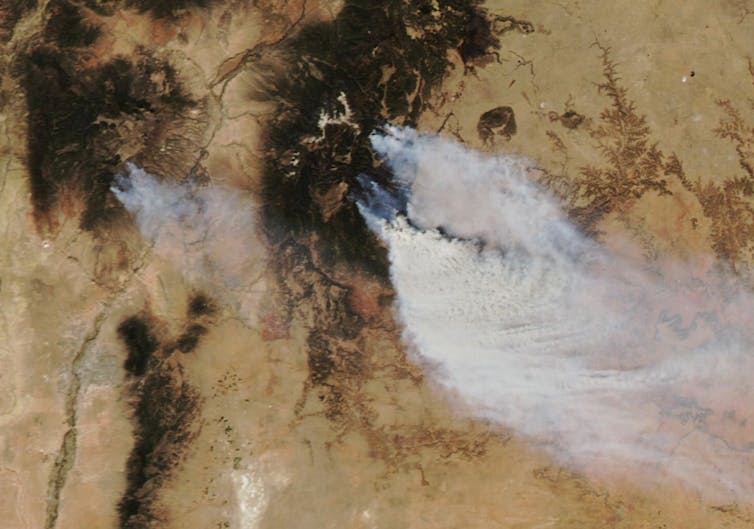
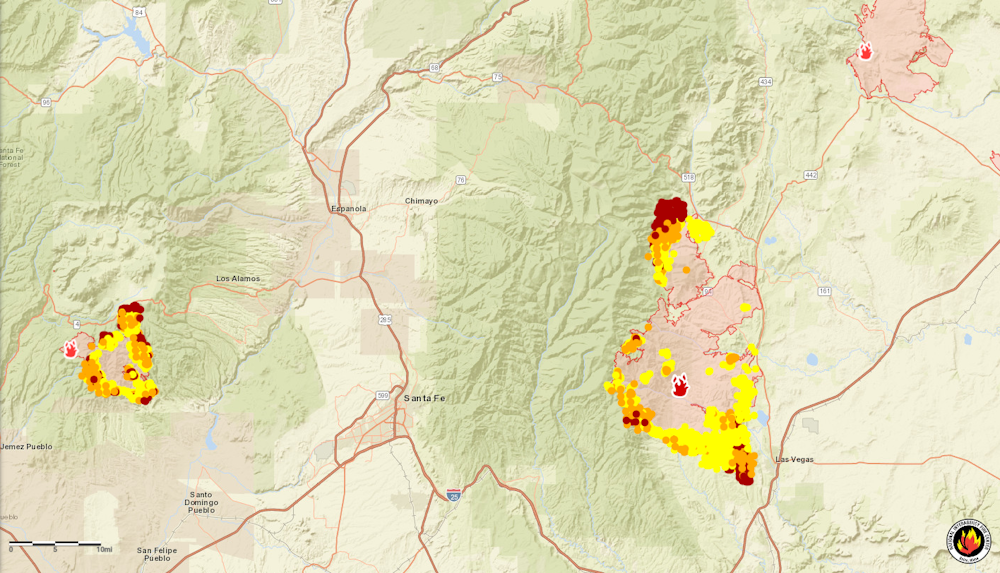
By May 4, nearly a quarter-million acres had burned in New Mexico, almost double the state’s 2021 total. Fires shown by satellite and on the map below are near Los Alamos and Las Vegas, N.M. NASA National Interagency Fire Center
What effect is the changing fire regime having on the Southwest’s ecosystems?
When fires burn in areas that didn’t see fire historically, they can transform ecosystems.
People generally don’t think of fire as being a natural part of desert ecosystems, but grasses are now fueling really big fires in the desert, like Arizona’s Telegraph Fire in 2021. These fires are also spreading farther, and into different ecosystems. The Telegraph Fire started in a desert system, then burned through chaparral and into the mountains, with pine and conifer forest.
Invasive buffelgrass is a threat to desert ecosystems and communities.
When a fire spreads in the desert, some plant species, like mesquite and other brushy plants, can survive. But the saguaro – the iconic cactuses that are so popular in tourist visions of the Southwest – are not well adapted to fire, and they often die when exposed to fire. Paloverde trees are also not well adapted to survive fires.
What does comes back quickly is the grasses, both native and invasive. So in some areas we’re seeing a transition from desert ecosystem to a grassland ecosystem that is very conducive to the spread of fire.
The Cave Creek Fire near Phoenix in 2005 is an example where you can see this transition. It burned over 240,000 acres, and if you drive around that area now, you don’t see lot of saguaros. It doesn’t look like desert. It looks like more like annual grassland.
What can be done to avoid high fire risk in the future?
In some respects, people will have to recognize that fire is inevitable.
Fires quickly now surpass our capacity to control them. When winds are strong and the fuels are really dry, there’s only so much firefighters can do to prevent some of these big fires from spreading.
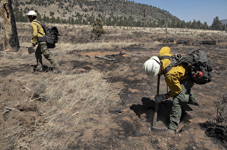
People clear trees from around a home as a fire threatens Las Vegas, N.M., on May 2, 2022. AP Photo/Cedar Attanasio
Conducting more prescribed fires to clear out potential fuel is one important way to lessen the probability of really big, destructive blazes.
Historically, far more money went into fighting fires than managing the fuels with tactics like thinning and prescribed fire, but the infrastructure bill signed in 2021 included a huge influx of funding for fuels management. There’s also a push to move some seasonal fire crew jobs to full-time, yearlong positions to conduct thinning and prescribed burns.
Homeowners can also be better prepared to live with fires. That means maintaining yards and homes by removing debris so they’re less likely to burn. It also means being prepared to evacuate.
This article was updated May 5 with Biden issuing the disaster declaration.
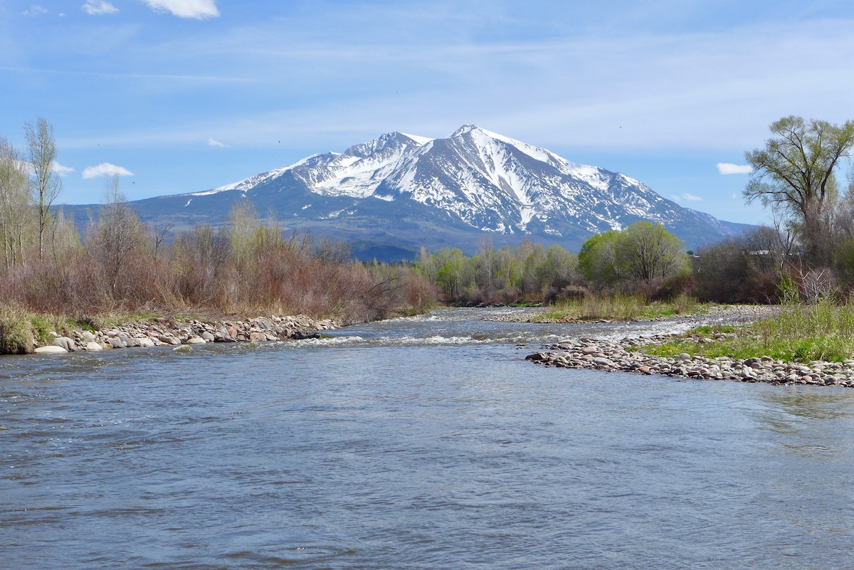
The Roaring Fork River just above Carbondale, and Mt. Sopris, on May 3, 2020. Photo credit: Brent Gardner-Smith/Aspen Journalism
Click the link to read the article on Sopris Sun website (James Steindler). Here’s an excerpt:
Becky Bolinger, the assistant state climatologist at the Colorado State University Climate Center, was the first presenter. She explained that snowpack determines the rivers’ flows. “Even though we’re doing okay with snowpack, we really needed above average snowpack to get the inflows back to where they need to be,” she stated.
West Drought Monitor map May 3, 2022.
“We are still struggling through this long-term drought situation,” Bolinger stressed. “The summer heat is a big concern and what the precipitation does is also going to be a big concern.”
[…]
[Linsay DeFrates] further stated that with every 1% rise in temperature, streamflow is reduced by 3-9%. “Last year, we ended at 89% snowpack, but we only had 32% inflow into Lake Powell,” DeFrates explained. She referred back to Bolinger’s presentation, stating that “thirsty soils are going to drink the snowmelt first, before it becomes streamflow.”
She continued, “As we go forward, it’s going to take organization nights like this where voices are brought to the table who might not have been there before. … It’s going to take recognizing that we can’t just wish away our reality anymore.”
This U.S. Drought Monitor (USDM) week was marked by ongoing active weather across areas of the conterminous U.S. including the Pacific Northwest, Northern Rockies, Plains, Lower Midwest, and isolated areas of the South and Southeast. The most severe weather was observed across the Central Plains and areas of the Midwest where numerous tornadoes touched down in areas including eastern Kansas, southeastern Nebraska, and northern Illinois. Widespread heavy rainfall accumulations were also observed, ranging from 2 to 7 inches, with the heaviest accumulations in eastern Nebraska. The rainfall events provided much-needed moisture to the region―boosting soil moisture levels across parched areas from Kansas to South Dakota. In the West, fast-moving storm systems delivered late season high-elevation snowfall to the Cascades of northern Oregon and Washington, the Northern and Central Rockies, and areas of the northern Great Basin. The highest snowfall totals (8 to 12+ inches) were observed in the Salmon River Mountains of Idaho, the Ruby Mountains of northeastern Nevada, and the Wind River Range of Wyoming. In California and the Southwest, conditions were dry during the past week with strong winds observed across the region. The windy, dry conditions exacerbated fire-weather conditions in Arizona and New Mexico where several large early-season wildfires are currently impacting the region. In northern New Mexico, the Hermits Peak Fire, situated east of Santa Fe in the Sangre de Cristo Mountains, has burned 147,909 acres and is only 20% contained (May 4), according to the National Interagency Coordination Center. On the water-resource front, the Colorado River Basin water situation continues to deteriorate due to the long-term impacts of drought with water levels at Lake Powell and Lake Mead currently at 24% full and 31% full, respectively. With Lake Powell’s water surface elevation currently at 3,522 feet, it is quickly approaching the 3,490-foot threshold level at which Glen Canyon Dam can continue to generate hydropower. The U.S. Bureau of Reclamation (USBR) announced (May 3) two urgent drought response actions to help bolster water levels at Lake Powell. The plan includes additional upstream releases from the Flaming Gorge Reservoir (~500,000 acre-feet [kaf] of water) as well as reducing Glen Canyon Dam’s annual release volume from 7.48-million acre-feet to 7 million acre-feet. In terms of this week’s map, short-term precipitation led to targeted improvements in the Pacific Northwest, Central Plains, South, and the Southeast, while degradations were registered in the Southwest, Texas, Southeast, and the Mid-Atlantic…
On this week’s map, widespread improvements were made in South Dakota, Nebraska, and Kansas in response to significant rainfall accumulations that helped to improve soil moisture levels and boosted streamflow levels. Rainfall totals for the week ranged from 2 to 8+ inches with the highest totals observed in central South Dakota, eastern and central Nebraska, and northern Kansas. However, some drought-stricken areas of the region, including extreme southeastern South Dakota, northeastern Nebraska, and central Kansas, largely missed out on this week’s storms. In the eastern plains of Montana, improving conditions (precipitation, soil moisture) led to reduction in areas of Severe Drought (D2) and Extreme Drought (D3). However, it should be noted that recent improvements in eastern Montana are not uniform and many areas are still coping with the impacts (agricultural) of the longer-term drought situation. Average temperatures were below normal across the northern half of the region, with negative departures ranging from 2 to 10+ deg F below normal and the greatest departures observed in eastern portions of the Dakotas. In the southern half of the region, average temperatures were 2 to 8 deg F above normal…
Colorado Drought Monitor one week change map ending May 3, 2022.
Out West, several storm systems moved through the norther tier of the region bringing light to moderate snowfall accumulations to the higher elevations of the Cascades, northern Great Basin, and the Central and Northern Rockies as well as light rainfall to coastal areas and low-lying inland valleys of Idaho, Oregon, and Washington. Improvements were made in areas of Moderate Drought (D1), Severe Drought (D2), Extreme Drought (D3), and Exceptional Drought (D4) in Oregon in response to a combination of factors including normal to above-normal SWE, recent storm events, and improved soil moisture levels and streamflows. Likewise, improving conditions in northern Wyoming led to removal of areas of Extreme Drought (D3) in the Big Horn Mountains where current SWE is 108% of median. Elsewhere, conditions deteriorated on the map in northwestern Arizona and across much of New Mexico. Looking at snowpack data across the West at a regional scale (2-digit HUC), the NRCS SNOTEL network (May 3) reported the following median SWE levels: Pacific Northwest 111%, Missouri 99%, Souris-Red-Rainy 116%, California 60%, Great Basin 62%, Upper Colorado 76%, Arkansas-White-Red 50%, Lower Colorado 36%, and Rio Grande 33%. According to NRCS National Water and Climate Center’s reservoir summary report (April 1), statewide reservoir storage levels were below normal in all western states with exception of Washington state. In California, the state’s two largest reservoirs are at critically low levels moving into the dry season with Shasta Lake currently at 40% of total capacity on May 3 and Lake Oroville at 55% of capacity. In Southern California, the Metropolitan Water District of Southern California announced (April 27) that one-third of its users will be subject to restrictions that limit outdoor watering to one day per week as a measure to reduce water usage. In the Colorado River Basin, Lake Powell was at 24% of capacity and Lake Mead 31% of capacity on May 3, according to the USBR. In the Rio Grande Basin, New Mexico’s Elephant Butte Reservoir was 13% full…
In the South, conditions on the map were a mixed bag of improvements and degradations. In southern Louisiana, isolated areas of light-to-moderate rainfall (2 to 4 inches) improved areas of Moderate Drought (D1), Severe Drought (D2), and Extreme Drought (D3) as well as eliminated pockets of Moderate Drought (D1) in northern Louisiana and southern Arkansas. In areas of Texas (Panhandle, north-central, west-central, Trans-Pecos), isolated bands of heavy rainfall (2 to 4 inches) helped to improve drought-affected areas. Conversely, the combination of above-normal temperatures, dry soils, and increased evaporative demand led to degradation in areas of the Panhandle, southeastern Texas, and the Trans-Pecos. In the Panhandle of Oklahoma, small areas of Exceptional Drought (D4) expanded in response to short-term rainfall deficits. Reports in this area include very poor rangeland conditions and local ranchers having to rely on supplemental feed for cattle. According to the latest USDA Oklahoma Crop Progress and Conditions report (May 2), wheat crop conditions were rated 51% poor to very poor and soil moisture was 63% short to very short. For the week, average temperatures were mostly above normal (2 to 8+ deg F) with the greatest positive anomalies observed across Texas and western Oklahoma…
Looking Ahead
The NWS WPC 7-Day Quantitative Precipitation Forecast (QPF) calls for moderate-to-heavy liquid (liquid = rain + SWE) precipitation accumulations ranging from 2 to 5+ inches across eastern portions of the Central and Southern Plains and the Lower Mississippi Valley. In the Lower Midwest and the Mid-Atlantic, precipitation totals are expected to range from 1 to 3 inches. Out West, accumulations ranging from 1 to 5 inches are forecasted for the coastal ranges and the Cascades of western Oregon and Washington. Further inland, lighter accumulations (< 2 inches) are expected in the Northern Rockies of Idaho, Montana, and Wyoming. Further south, conditions are expected to be dry across California, the Great Basin, and the Desert Southwest. The CPC 6-10-day Outlooks calls for a moderate-to-high probability of above-normal temperatures across the eastern two-thirds of the conterminous U.S. with exception of some coastal areas of the Mid-Atlantic and Florida. Below-normal temperatures are expected across much of the West with exception of eastern portions of Colorado and New Mexico where there is a low-to-moderate probability of above-normal temperatures. In terms of precipitation, the wetter-than-normal pattern is expected to persist across the northern tier of the West as well as in areas of the Great Plains. In coastal areas of the Far West, near-normal precipitation is expected. Across much of the eastern half of the conterminous U.S., including areas of the Southern Plains, Lower Midwest, Mid-Atlantic, and the Northeast, there is a moderate-to-high probability of below-normal precipitation.
US Drought Monitor one week change map ending May 3, 2022.
Just for grins here’s a gallery of early May US Drought Monitor maps from the US Drought Monitor.
The May 1 CBRFC unregulated Powell A-J inflow forecast has dropped 300kaf to 3.8 maf. The regulated inflow (from the 24-M study) may drop less – But still nature has cut the net impact of the 480 kaf release reduction to 180kaf. pic.twitter.com/j4xgJ2Em7w
Click the link to read the article on the Rolling Stone website (Jeff Goodell). Here’s an excerpt:
The clock is running on the climate crisis, but we have the tools and knowledge — and the crickets — that we need
The climate crisis is here, and heartbreak is all around us. The early promise of dramatic action from President Biden is sinking in the old mud bog of fossil-fuel politics. Meanwhile, despite 40 years of warnings from scientists and the decline in the cost of clean energy, carbon pollution is still increasing and the world is heating up as fast as ever. The final sentence of last February’s U.N.’s latest Intergovernmental Panel on Climate Change (IPCC) report on the impacts of that warming is stark and unequivocal: “Climate change is a threat to human well-being and the health of the planet. Any further delay in concerted global action will miss a brief and rapidly closing window to secure a livable future.” Or as U.N. Secretary-General António Guterres put it after an IPCC report on the mitigation of climate change was released this month: “Investing in new fossil fuels infrastructure is moral and economic madness.”
[…]
1. Tax carbon.
In February, Rhode Island Sen. Sheldon Whitehouse took to the Senate floor for his 280th “Time to Wake Up!” speech about the climate crisis. The centerpiece of Whitehouse’s plan was the need for a tax on fossil fuels. It is an argument that speaks to a truism of economics: to make something scarce, tax it…
Leaf charging at the Lionshead parking facility in Vail September 30, 2021.
2. Electrify everything.
In the U.S. there are roughly 290 million cars and trucks, 70 million fossil-fueled furnaces, 60 million fossil-fueled water heaters, 20 million gas dryers, and 50 million gas stoves. What if all those were electrified? Saul Griffith, an Australian American engineer and author of Electrify: An Optimist’s Playbook for Our Clean Energy Future, thinks electrification can reduce 80 percent of U.S. emissions by 2035…
A solar parking facility at Rutgers University in Piscataway, New Jersey, with an output of 8 megawatts of electricity.
3. Go local with solar.
It’s now obvious: The future is solar on homes, solar on apartment buildings, solar on malls, solar on parking lots, solar on fast-food joints, burrito stands, and strip clubs. With the sun, small is beautiful. Wasted space becomes a platform for power generation. With solar, cost has always been a problem, but that is ending now as the price of solar panels has plummeted over the past decade. Nobody pretends that you are going to make steel from solar, or that it will be the best way to generate power in every situation,but it is clean and reliable and won’t go down in a blackout like the one in 2021 that left 11 millions Texans freezing in the dark for days and was responsible for as many as 700 deaths…
Xcel Energy proposes to close two of its coal-fired generating units at Comanche, indicated by smokestacks at right. The stack at left, for the plant completed in 2010, provides energy for a portion of Aspen and for the Roaring Fork and Eagle valleys. In the foreground is the largest solar farm east of the Rocky Mountains at its opening. Photo/Allen Best
4. Buy out coal plants.
Coal is the dirtiest, most carbon-intensive fossil fuel, responsible for 30 percent of global carbon emissions. The biggest coal burner is China, which consumes more coal than the rest of the world combined. Here in the U.S., coal is slowly being displaced by cheap gas, wind, and solar. But there are still 179 active coal plants, generating 20 percent of U.S. electricity. Shutting them down and replacing them with cleaner, cheaper energy is the fastest way to lower carbon emissions and slow the climate crisis. “The transition beyond coal is inevitable,” says Justin Guay, director for global climate strategy at the Sunrise Project. “But the timeline on which it happens isn’t.”
[…]
Denver School Strike for Climate, September 20, 2019.
5. Start telling the truth about the climate crisis.
How much is that $2 million house on the beach going to be worth when there’s an octopus swimming through the living room? What’s going to happen to all those refineries on the Gulf Coast as the demand for oil plummets? Banks and corporations face huge financial risks as the age of climate disruption accelerates. One just-published report found around $343 billion in weather- and climate-related economic losses in 2021 alone, the third-costliest year on record. A 2019 study concluded that 215 of the world’s largest companies face nearly $1 trillion in climate-related risk as soon as 2024. Very little of this is disclosed in corporate financial reports. “The coronavirus pandemic has laid bare just how vulnerable the United States is to sudden, catastrophic shocks,” Sarah Bloom Raskin, Biden’s nominee to the Federal Reserve Board of Governors, wrote in The New York Times. “Climate change poses the next big threat.”
[…]
Denver Water’s planned new administration building via the Denver Business Journal
6. Build denser, fairer, more humane cities.
Urban life is far gentler on the planet than suburban life. People who live in cities spend less time stuck in traffic in their SUVs; they have better access to local food; they live in buildings that are more efficient. But cities need a climate upgrade too: more bikes, better public transit, more green space…
Bears Ears Protest in Salt Lake December 2, 2017. Photo credit: Mother Jones Magazine
7. Get loud and hit them where it hurts.
The biggest roadblock to climate action has always been the cowardice and complicity of our political leaders. For many, the lack of significant accomplishments at last year’s Glasgow climate talks and the failure of Biden’s Build Back Better agenda have been a brutal awakening. “Activists have become jaded because there’s been a lot of promises from politicians without a lot of action to back it up,” says Dana Fisher, an environmental-activism expert at the University of Maryland and author of American Resistance. “A lot of young people are looking at other tactics now.”
[…]
Graphic credit: The Nature Conservancy
8. Fund small-scale geo-engineering research.
Maybe Dr. Evil wants to deliberately fuck with the Earth’s climate, but nobody else does. Nevertheless, it’s probably inevitable, given the risks we face. There are many potential forms of geoengineering, from brightening clouds to stabilizing glaciers, but the technology that gets the most attention is solar engineering, which amounts to scattering particles in the stratosphere to reflect away sunlight and cool the Earth. Scientists know it works because it’s essentially what volcanoes do (particles injected into the stratosphere from Mount Pinatubo, which erupted in 1991, cooled the planet 0.6 C for more than a year, until they rained out of the sky)…
9. Eat crickets!
America’s (and, increasingly, the world’s) appetite for meat is barbecuing the planet. Livestock eat up a lot of land, drive deforestation, and are carbon-intensive in their own right. Without reforming industrial agriculture and reducing meat consumption, it will be virtually impossible to limit warming to 2 C, much less 1.5 C…
Protest against Enbridge’s Line 3 pipeline in Minnesota. Photo: Dio Cramer
10. Fight and win the culture war.
Much has been said about the failure of Big Media to cover the climate crisis. It’s too often pigeonholed as an environmental issue rather than a slow-rolling planet-wide catastrophe. Or it’s infused with “both-sidesism,” in which journalists are duped into the false idea that there is any real debate about the fundamentals of climate science. Or it’s just not discussed at all. When Hurricane Ida slammed into the Gulf Coast late last summer, six of the biggest commercial TV networks in the U.S. — ABC, CBS, CNN, Fox, NBC, and MSNBC — ran 774 stories about Ida, an analysis by the watchdog group Media Matters found. Only 34 of those stories mentioned climate change. Mark Hertsgaard, the executive director of Covering Climate Now, an initiative dedicated to improving climate reporting, calls it “media malpractice.”
Secretary of the Interior Deb Haaland, center, and U.S. Rep. Veronica Escobar of Texas, right, visit Castner Range National Monument in Texas on March 26, 2022. (Courtesy of Interior Department/Public domain)
Interior Secretary Deb Haaland will ask a U.S. House spending panel to increase funding for the department’s tribal programs and climate resilience efforts, according to written testimony released ahead of a hearing scheduled for Thursday.
The administration’s budget request for fiscal 2023 would significantly increase spending for the Interior Department. Its agencies oversee onshore oil and gas drilling, tribal assistance, national parks and wildlife policy, and manage public lands accounting for 10% of acreage across the country.
Haaland’s written testimony to the House Appropriations Energy-Environment Subcommittee was published on a House website ahead of the hearing.
GET THE MORNING HEADLINES DELIVERED TO YOUR INBOX
The budget “sets ambitious goals, but they are achievable,” Haaland’s written testimony to the committee reads. “Working together, we have the opportunity to invest now to strengthen our Nation for all Americans, protect our environment, and ensure our future generations continue to not only enjoy, but improve our way of life.”
Haaland is scheduled to appear before the panel Thursday. Her opening statement will likely be shortened from the written version. Members of the panel will be able to question her.
Though President Joe Biden released a budget request last month, Congress has the sole authority to write spending bills. Cabinet officials typically appear on Capitol Hill to defend the spending request as part of the process.
Biden’s request included a 19% increase for Interior — nearly four times the 5% boost for all domestic discretionary spending. Haaland’s written testimony summarizes some of the largest line items in the proposal.
At several points in the testimony, Haaland characterizes the fiscal 2023 request as a supplement to the $1.2 trillion bipartisan infrastructure law that included billions for Interior programs to clean up abandoned mines, reduce wildfire risk and build water infrastructure.
Her remarks call for passing a 2023 funding bill that “complements this investment.”
Tribal programs
Biden’s fiscal 2023 request includes a significant boost for several funding sources for tribes.
Haaland, who is the first Native American person to serve in a Cabinet, wrote that it was “deeply meaningful” for her to promote the budget blueprint, including the request for tribal programs.
The administration proposed increasing spending on Indian Affairs programs by nearly 25% to $4.5 billion, a sum Haaland called “unprecedented.” The request would prioritize sovereignty and advance equity and opportunity for tribal communities, Haaland said.
The infrastructure law provides $2.5 billion to help deliver water resources to tribes. That spending is included in the request, as is another $340 million over 10 years to support the operation and maintenance of that effort.
The Bureau of Indian Affairs would receive $2.8 billion, an increase of more than $500 million from fiscal 2022. A major piece of that funding would go toward operating costs for tribal self-governance of federal programs.
Bureau of Indian Education funding would go from $1.3 billion in fiscal 2022 to $1.6 billion under the Biden request. Construction money for tribal schools would see a nearly 60% increase to $420 million.
Climate priorities
Haaland will ask for funding to help transition to renewable energy and take other steps to mitigate climate change, while also highlighting the need to adapt to a certain amount of climate change that is already unavoidable.
“Worsening drought, increased weather risks, more extreme wildfires, profound threats to wildlife habitats, warming water temperatures, and new threats from invasive species are among the tangible challenges land and resource managers face right now,” her testimony reads.
The request includes $1.4 billion for Bureau of Reclamation water projects to deal with droughts that are expected to worsen in coming years. That funding would build on $8.3 billion in the infrastructure law.
A separate Appropriations panel, the Energy-Water Subcommittee, is responsible for that part of the department’s funding.
The request also includes $1.2 billion for wildfire management, an increase of nearly $175 million over the fiscal 2022 level.
The request would also target climate resilience spending for tribal communities. The administration has asked for $61 million for a tribal climate resilience program, nearly double the $32 million enacted for the current fiscal year.
The request includes funding across several Interior agencies for restoration and conservation.
“Healthier lands are more resilient to the effects of the changing climate, and investments that are made now will help ensure the unique and spectacular lands and resources Interior manages endure for future generations,” the testimony says.
The department also continues to work on its initiative to protect 30% of lands and waters by the end of the decade. Haaland’s testimony does not mention specific funding for the program.
Interior support of jobs
The Interior department supported an estimated 1.9 million jobs in 2019, according to Haaland’s testimony.
Those jobs were mainly driven by the department’s energy programs.
The 2023 request includes extra funding to spur job creation from money in the infrastructure law and the Great American Outdoors Act, a 2020 law that provided permanent funding for public lands infrastructure, Haaland said.
The administration’s request aims to grow renewable energy sources, but spending on wind and solar is still dwarfed by oil and gas programs.
The request would provide about $101 million for renewable energy programs for the Bureau of Ocean Energy Management and the Bureau of Land Management programs. It would also send $11 million to the BLM to plan renewable energy projects on public lands.
Meanwhile, the request calls for $477 million for oil and gas programs, 13% more than the same programs received in 2022.
The administration’s climate and conservation programs will also create jobs, Haaland says, including in a Civilian Climate Corps and through new jobs in clean energy.
Still, Interior plays a role “in balancing conservation and development,” Haaland will tell the committee.
The budget request includes money to speed permitting for clean energy infrastructure and for a Fish and Wildlife Service program to support development that protects migratory birds.
SUPPORT NEWS YOU TRUST.
Colorado Newsline is part of States Newsroom, a network of news bureaus supported by grants and a coalition of donors as a 501c(3) public charity. Colorado Newsline maintains editorial independence. Contact Editor Quentin Young for questions: info@coloradonewsline.com. Follow Colorado Newsline on Facebook and Twitter.
Air-source heat pumps at the home of Joe Smyth and Kristen Taddonio in Fraser, Colo. Photo/Joe Smyth
Click the link to read the article on the Big Pivots website (Allen Best):
The coldest temperature this winter at the new home of Joe Smyth and Kristen Taddonio was 17 below. They live in Fraser, the Colorado town that used to get far, far colder.
Still, that February night was cold enough to test the design and technologies employed in construction of the couple’s 1,176-square-foot house. They insulated carefully, of course, and have solar panels. Even after charging their electric car, their house produces more energy than it consumes.
An air-source heat pump was central to their mission in creating a net-zero home, one gutted of emissions from fossil fuels. It extracts heat from outside, even on chilly nights, to warm the interior.
The Mitsubishi model used at the Fraser house promises to deliver the necessary indoor heat even when outside temperatures dip to 13 below. To supplement the air-source heat pump should temperatures dive to 30 below, as was once common, the couple also installed electrical-resistance heating. It wasn’t needed.
Colorado needs many more air-source heat pumps — and fewer carbon emissions from buildings — to meet its mid-century decarbonization target goals of 90%.
Getting this right during housing construction costs less in the not-very-long term. Building permits for 48,200 housing units, both single-family and multi-family, were issued last year, according to the Colorado Business Economic Outlook. That’s like adding a new Greeley each year along with a few small towns.
Retrofitting our older buildings is laborious and expensive. I know, because my house was built in 1889. You don’t swap out buildings the way you would computers or cars.
Several bills working their way through the Colorado Legislature this spring would nudge Coloradans toward low- and no-carbon technologies. All cost more upfront, but save money, sometimes lots of it, over time, while reducing or eliminating emissions.
Carrots would be offered by SB22-051 to those who purchase air- and ground-source heat pumps. Purchasers would be allowed income-tax exemptions of up to 10% of the purchase price.
Other provisions in the bill approved by the House Energy and Environment Committee offer tax incentives for energy storage and buildings materials with low levels of embodied carbon.
Christine Brinker, representing the Southwest Energy Efficiency Project, testified that her family’s air-source heat pump paid for itself in six years because of lower energy costs. Air-source heat pumps help residents of Geos, a project in Arvada, to pay as little as $6 a month in energy costs.
“It is just more efficient to move heat than to create heat,” said Rep. Mike Weissman, a Democrat from Louisville and a bill supporter. “I think we can do some good here by amending that pay-off time curve just a little bit. That’s something that we need to do to facilitate our transition” from fossil fuels.
Air-source heat pumps can also move heat from inside buildings during summer, effectively becoming air conditioners. Even in Winter Park, real estate buyers expect air conditioning.
The second bill, HB-1362, would require towns, cities, and counties to adopt the 2021 International Energy Conservation Code before 2025. This latest code advances efficiency 8% to 9% compared to the 2018 iteration.
Natural gas will still be allowed, but air-source heat pumps more efficiently meet the 2021 code’s elevated standards.
The Colorado Municipal League objected to loss of local control. Two representatives of rural areas described it as onerous for small towns despite $3 million earmarked for training. Homebuilders argued that the advanced standards would make already expensive housing less affordable.
Howard Geller, representing the Southwest Energy Efficiency Project, cited a study from the Pacific Northwest National Laboratory that found the latest code would indeed add $200 to the cost of an average mortgage in Colorado built to this latest code. Lower energy costs will more than recoup that extra cost, he said, even in the first year.
Rep. Tracey Bernett, a Democrat from Longmont whose district includes nearly half the 1,084 homes destroyed by the Marshall Fire, said she sponsored the bill with full confidence it will help, not harm, her constituents.
These bills both moved from the House committee on strictly party-line votes, Democrats in support. A third bill, HB22-1381, has bipartisan sponsors — and bipartisan support. It would allocate $20 million for grants to further geothermal development by tapping the year-round heat of 55 degrees found 8 to 10 feet below the surface.
As with air-source heat pumps, sponsors said the market needs to be nudged to adopt technology that costs more upfront than installing natural gas infrastructure but pays off in the long term. “This is something we don’t do enough of,” said Rep. Hugh McKean, a Republican from Loveland, who is installing geothermal in a house he is constructing.
“I really like this bill,” said Perry Will, a Republican from New Castle, citing the experiences of family members with the technology at Rulison and elsewhere.
Common Raven. Photo: Doug Kliewer/Audubon Photography Awards
Click the link to read the call to action on the Audubon website (Jennifer Pitt):
The Colorado River Basin is inching ever closer to “Day Zero,” a term first used in Cape Town, South Africa when they anticipated the day in 2018 that taps would run dry. Lakes Powell and Mead, the Colorado River’s two enormous reservoirs, were full in 2000, storing more than four years of the river’s average annual flow. For more than two decades water users have been sipping at that supply, watching them decline. Long-term drought and climate change is making this issue potentially catastrophic.
Today the entire Colorado River reservoir storage system is 2/3 empty.
Moreover, federal officials project that within two years, the water level in Lake Powell could be so low that it would be impossible for water to flow through the dam’s turbine intakes. When that happens, it’s clear the dam will no longer generate hydropower, but it’s also possible the dam will not release any water at all. That’s because the only other way for water to move through the dam when the water is low is a series of outlet tubes that were not designed, and have never been tested, for long-term use.
What happens if little to no water can be released from Lake Powell? Water supply risks multiply for everyone who uses water downstream. That includes residents of big cities like Las Vegas, Phoenix and Los Angeles, and farmers and ranchers in Arizona, California and Mexico who grow the majority of our nation’s winter produce, as well as numerous Native American tribes. Some of these water users have alternative supplies, but some—including Las Vegas residents, Colorado River tribes and most farmers—do not. Day Zero for these water users might not happen immediately as Lake Mead, the reservoir fed by Lake Powell still has some water in it. But without flows from upstream to replenish it, Lake Mead would also be at risk of no longer being able to release water.
There is also the river itself. Think of it—no water flowing through the Grand Canyon. No water flowing in the Colorado River for hundreds of miles downstream from Hoover Dam. That’s an ecological disaster in the making for 400 bird species and a multitude of other wildlife, exceeding the 20th century devastation of the Colorado River Delta.
In recent days, state and federal officials have announced plans to address the immediate crisis. These plans will help, but only to avert the immediate danger looming over the basin for the current year. They do nothing to decrease the unrelenting risks of Colorado River water supplies and demands out of balance, because all they do is move water from one place to another. The federal plan to reduce water releases from the Glen Canyon Dam will help this year, as Lake Powell will hold onto water that would otherwise have flowed downstream to Lake Mead. Notably, Lower Basin water users will calculate their uses as if the water was in Lake Mead anyway, delaying deeper cuts and further depleting the reservoir. The Upper Basin states also plan to release additional water from Flaming Gorge reservoir upriver in Wyoming to increase the inflow into Lake Powell. This too will help Powell, but it will reduce the supply in Flaming Gorge reservoir. The plan acknowledges this supply may not be recovered unless and until storage at Lake Powell considerably improves. Both of these plans will move water and help protect the Glen Canyon Dam’s operations in the near-term.
Moving water does not address the fundamental challenge in the Colorado River Basin and does not offer any real certainty for water users or the river itself in any corner of the basin. Colorado River water demands exceed supplies. Audubon knows that fundamentally, because we work on restoring habitat in the Colorado River Delta, where the river has not flowed regularly for half a century. With major reservoirs only one third full, plans that continue to drain them are not sustainable plans.
Brad Udall: Here’s the latest version of my 4-Panel plot thru Water Year (Oct-Sep) of 2021 of the Colorado River big reservoirs, natural flows, precipitation, and temperature. Data (PRISM) goes back or 1906 (or 1935 for reservoirs.) This updates previous work with @GreatLakesPeck.
Climate change is drying out the Colorado River. In the last two decades, the river’s flow has been 20 percent less than the average flow recorded in the 20th century. Hoping for a rainy season won’t fix this. Today’s water supply conditions are likely to be among the best we see over the coming decades.
What’s needed now, urgently, is for federal and state water managers to work, in partnership with tribes and other stakeholders, to take the steps necessary to build confidence in the enduring management of the Colorado River. This will require focus and dedicated resources to develop and implement plans that put water demands into balance with supplies. That means moving beyond year-to-year reactions to imminent risks to engage in planning that promotes water conservation. Water conservation means using less water, preferably managed in a way that both respects our system of water rights and supports society’s 21st century values, including economic stability for urban and rural communities, allowances for Native American tribes to realize benefit from their water rights, and reliable water supplies for nature.
People and birds rely on the Colorado River, and Audubon will continue to work with partners to advocate for and implement solutions. We know what works. Water conservation pilots implemented throughout the basin and across municipal and agricultural sectors have been successful. Investments in infrastructure upgrades have durably made water uses more efficient, and investments in habitat restoration have benefited ecosystems and the birds that rely on them. Flexible water sharing mechanisms have modernized water uses while protecting legal water rights and helped Tribes secure benefits. There is no time like the present to begin implementing these solutions at scale. They should be the foundation for new rules for how we use and protect the Colorado River.
Colorado River “Beginnings”. Photo: Brent Gardner-Smith/Aspen Journalism
A rare sight: Water shoots out of Glen Canyon Dam’s river outlets or “jet tubes” during a high-flow experimental release in 2013. Typically all of the dam’s outflows go through penstocks to turn the turbines on the hydroelectric plant. The outlets are only used during these experiments, meant to redistribute sediment downstream, and when lake levels get too high. Spillways are used as a last, last resort. The river outlets may be used again in the not so distant future: Once Lake Powell’s surface level drops below 3,490 feet, or minimum power pool, water can no longer be run through the turbines and can only be sent to the river below via the outlets. This is cause for concern because the river outlets were not built for long-term use. Jonathan P. Thompson photo.
The Bureau of Reclamation announced today a Macroinvertebrate Production Flow, or Bug Flow, will be conducted this summer at Glen Canyon Dam under the Long-Term Experimental and Management Plan. This experiment is designed to improve egg-laying conditions for aquatic insects that are the primary food source for fish in the Colorado River. The experiment will begin May 1 and continue through August 31, 2022.
The decision to conduct this experiment was based on input from a collaborative team, including the Department of the Interior’s Bureau of Reclamation, U.S. Geological Survey, National Park Service, U.S. Fish and Wildlife Service and Bureau of Indian Affairs. Flow experiments are designed to optimize benefits to the Lees Ferry Reach and Grand Canyon’s Colorado River ecosystem while meeting water delivery requirements and minimizing negative impacts to hydropower production.
“We are pleased to continue our research on the effects of modifying release flow patterns to benefit the Colorado River ecosystem,” said Michael Moran, Acting Chief of the U.S. Geological Survey Grand Canyon Monitoring and Research Center, which monitors Colorado River ecosystem response to all Glen Canyon Dam flow experiments. “Past research has shown that many different resources have benefitted from previous experimental flows, and we are looking forward to collecting this additional data on the river.”
Bug Flows are a water flow experiment that consists of steady, low weekend releases from Glen Canyon Dam and normal fluctuating releases for hydropower during weekdays. Bug Flows do not affect total annual, monthly or weekly release volumes from Lake Powell through Glen Canyon Dam, but slightly modify release schedules and flow rates. Recreational river users will likely notice steady flows resulting from the steady weekend releases as they move downstream through the Lees Ferry Reach and the Grand Canyon. Dam releases and minimum flows are within the range typically experienced by recreation users (e.g., anglers, boaters, kayakers and campers).
“In this time of unprecedented drought, continuing experiments like Bug Flows in compliance with the Grand Canyon Protection Act is critical,” said Reclamation’s Upper Colorado Basin Regional Director Wayne Pullan. “At the same time, drought makes assessing and mitigating for the effects of those experiments on other resources like hydropower, water supply and recreation increasingly important.”
The purpose of these experimental flows is to identify whether this type of operation can improve the abundance, diversity and stability of aquatic insect populations, thereby increasing aquatic insect prey available for a variety of wildlife. Insects expected to benefit from this experiment are an important food source for many species of fish, birds, and bats in the canyon. Insects expected to benefit from this experiment are an important food source for many species of fish, birds, and bats in the canyon.
Bug Flow experiments were implemented at Glen Canyon Dam from May through August for three consecutive years: 2018, 2019 and 2020, but were not implemented in 2021. Findings suggest that the previous Bug Flow experiments may have improved conditions for adult insects, increased the abundance of caddisflies river wide, and increased algae production. In addition, anglers captured more rainbow trout on average during Bug Flows than they did during typical fluctuating flow patterns. Contrary to predictions, no increase in the abundance of midge’s flies were observed during the first three years of the experiment. Scientists believe that further experimentation, research and monitoring may help to determine whether the Bug Flows experiment benefits native fishes in the Lees Ferry Reach below the Glen Canyon Dam and in the Grand Canyon. This experiment provides scientific information important to future decision-making.
The Glen Canyon Dam Implementation Team will closely monitor the condition of resources during the experiment and may terminate implementation at any time if unanticipated negative impacts are observed or are likely to occur due to ongoing drought and low lake levels.
Ute Mountain Chairman Manuel Heart and Southern Ute Council member Lorelei Cloud presented their perspectives and plans for water management during a session of the Southwestern Water Conservation District’s annual meeting Friday [April 22, 2022] in Durango. The tribes were not invited to the discussions when the states and federal government divided water rights in the West during the early 20th century. Native Americans did not gain U.S. citizenship until two years after the 1922 Colorado River Compact divided Colorado River water between upper and lower basins.
Cloud said the Southern Ute Tribe has 129,000 acre-feet per year of federally reserved water rights on seven rivers that run through its reservation, but they only have the capacity to divert 40,600 acre-feet per year. The tribe stores water in Vallecito, Lemon and Lake Nighthorse Reservoirs.
The tribe recently built a reservoir to store water for its water treatment plant, which serves 500 households, many of which are nontribal homes in the checkerboard area of the reservation that includes private and tribal lands. The new reservoir allows for a 30-day reserve, up from one-day reserve. Water storage at the treatment plant is critical because it is served by the tribe’s junior water rights on the Pine River, which are vulnerable to calls from senior right holders…
In a historic meeting on March 28 in Albuquerque, 20 tribes, including Utes, met with U.S. Department of Interior Secretary Deb Haaland to discuss their involvement with Colorado River Basin water negotiations. Haaland is the first Native American appointed to the post. Cloud said tribes are now at the table to provide input on the Drought Response Operation Agreement set by the Bureau of Reclamation. The guidelines determine how water is released from Colorado River storage reservoirs.
Subdistrict 1 Program Manager Marisa Fricke clears paths for water to flow onto land the subdistrict owns. The property is one of the subdistrict’s investments in recharging the aquifer. Photo credit: The Alamosa Citizen
MOTHER Nature will determine how much groundwater pumping occurs in ag-rich Subdistrict 1 of the Rio Grande Water Conservation District under a new plan of water management making its way to the state for approval.
The subdistrict and its parent Rio Grande Water Conservation District have been under pressure to bring the unconfined aquifer of the Upper Rio Grande Basin to a sustainable level or face curtailment of wells. The San Luis Valley has two aquifers – one unconfined and one confined.
In the draft of its new plan, which is the fourth amendment to the subdistrict’s Plan of Water Management, Subdistrict 1 members spell out the situation with the unconfined aquifer:
“Although the Subdistrict successfully remedied injurious depletions to senior surface water rights caused by groundwater withdrawals from Subdistrict Wells, it has not been successful in achieving and maintaining a Sustainable Unconfined Aquifer. This Plan is intended to address the now-apparent deficiencies of the previous Amended Plans of Water Management and adopts new means needed to achieve a Sustainable Unconfined Aquifer.
“The Subdistrict realizes that if more restrictive steps are not taken to achieve a Sustainable Unconfined Aquifer, the State Engineer will, at some point, be unable to approve a future Annual Replacement Plan, resulting in the curtailment of Subdistrict Wells. State Engineer denial of an Annual Replacement Plan could result in the curtailment of all Subdistrict Wells, causing severe negative impact on the agricultural economy of the Subdistrict and the San Luis Valley as a whole.”
The board of managers for Subdistrict 1 gave final approval to the plan on Tuesday. It now goes to the Rio Grande Water Conservation District Board for consideration. If approved there, it would be submitted to the Colorado Department of Water Resources and State Engineer Kevin Rein for review and approval.
“A lot of hard work has gone into this from everyone involved,” said Subdistrict 1 Board President Brian Brownell. “It’s been a struggle. Overall this is the best plan we could come up with.”
The amended plan relies on covering any groundwater withdrawals with natural surface water or the purchase of surface water credits.
The subdistrict is asking the state for 20 years to make the plan successful in recovering the aquifer, with a goal to restore 40,000 to 50,000 acre-feet a year over that 20-year period to bring the unconfined aquifer to a sustainable level.
TO get there the plan calls for a 1-to-1 augmentation, meaning for every acre-foot of water used, an acre-foot has to be returned to the unconfined aquifer through recharging ponds.
“Our pumping will be adjusted to whatever climate brings us,” said ex-officio board member Mike Kruse.
If the Valley experiences wet periods, groundwater pumping in Subdistrict 1 can match it. If the Valley continues with the persistent drought it has experienced over the past 20 years, groundwater pumping in the subdistrict will reflect the dryness.
“This plan takes into account the climate. That’s the beauty of it,” Kruse said
The predicament of the depleted unconfined aquifer is the result of the state granting too many well permits for groundwater pumping decades ago, now coupled with decades of drought going back to 2002.
“The state has to bear some responsibility,” said Subdistrict 1 board member James Cooley. “It isn’t all our fault.”
Subdistrict 1 Program Manager Marisa Fricke said the subdistrict had been making progress toward meeting the state’s goals with the unconfined aquifer up until 2018, when a particularly dry year hit the Valley. A wet 2019 brought some relief to the aquifer, but the subdistrict lost the progress it made after back-to-back dry years in 2020 and 2021, and now so far 2022.
The change in climate, said Brownell, has been the biggest factor in working to restore the unconfined aquifer. “It’s nothing anybody could have foreseen and that is why we’re addressing it.”
“This concept we have is probably the only way we can address climate,” said Subdistrict 1 Board Member Jake Burris. “With this plan we’re living within our means.”
Based on modeling conducted by Willem Schreuder, president of Principia Mathematica in Denver, there is a high level of confidence among farm operators that the new plan will succeed in meeting the state’s requirement of a sustainable unconfined aquifer. The earliest the amended plan would take effect is for the 2023 irrigation season.
Some farm operators in Subdistrict 1 are filing their own augmentation plans with the state Division 3 Water Court in lieu of joining a new amended plan by the conservation district.
Renewable Water Resources, in its discussions with Douglas County, has tried to use the unconfined aquifer condition in Subdistrict 1 to further its case by approaching farmers with buyouts for their water rights. The RWR water exportation proposal is not in Subdistrict 1, but that hasn’t stopped RWR from trying to leverage the situation to their advantage, telling Douglas County that farmers in the Valley are facing imminent widespread water well curtailments, which isn’t the case.
Douglas County Commissioner Abe Laydon made it a point in his recent visit to the San Luis Valley to bring up well shut downs as a reason why Douglas County could help the Valley by investing in Renewable Water Resources and buying out farmers and establishing a Valley-wide community fund.
A state Senate bill offered by Sen. Cleave Simpson, who also works as general manager of the Rio Grande Water Conservation District, would help address the strategy of retiring groundwater pumping wells in all the Valley’s subdistricts. If adopted – the proposed legislation has cleared major committee hurdles – the Compact Compliance Fund would make available at least $30 million to the Rio Grande Basin to help with groundwater sustainability measurements and would offer the Rio Grande Water Conservation District another pot of money to execute its strategies.
This beaver pond formed upstream of a partially breached beaver dam in the headwaters of Colorado’s Fryingpan River. The photo illustrates how even abandoned dams can support wetland habitat and capture sediment in mountain watersheds. Photo Credit: Sarah Marshall
Click the link to access the paper on the WIREs website (Chris E. Jordan, Emily Fairfax). Here’s the abstract:
Rivers and streams, when fully connected to their floodplains, are naturally resilient systems that are increasingly part of the conversation on nature-based climate solutions. Reconnecting waterways to their floodplains improves water quality and quantity, supports biodiversity and sensitive species conservation, increases flood, drought and fire resiliency, and bolsters carbon sequestration. But, while the importance of river restoration is clear, beaver-based restoration—for example, strategic coexistence, relocation, and mimicry—remains an underutilized strategy despite ample data demonstrating its efficacy. Climate-driven disturbances are actively pushing streams into increasingly degraded states, and the window of opportunity for restoration will notstay open forever. Therefore, now is the perfect time to apply the science of beaver-based low-tech process-based stream restoration to support building climate resilience across the landscape. Not every stream will be a good candidate for beaver-based restoration, but we have the tools to know which ones are. Let us use them.
Click the link to read the article on the NOAA website (Michael Tippett and Tim Delsole):
This is a guest blog by Michael Tippett (professor at Columbia University) and Tim DelSole (professor at George Mason University), adapted from material in their new text book Statistical Methods for Climate Scientists.
Predictability is a word that often comes up in discussions here on the ENSO Blog (another is variability). Let’s see if we can understand what climate scientists mean by predictability without having to read an entire book on statistics! As you might guess, climate scientists use the word predictability a little differently than the rest of the world. For instance, you might say that I am predictable because I take the same path each day on my morning walk, with small variations. On the other hand, for a climate scientist concerned with predictability, the question is whether it’s possible to forecast how my walk tomorrow will differ from its usual path (footnote #1).
Predicting that I’ll take my usual path is a climatological forecast in the sense that it is based only on the long-term average (climate) of past events. For a climate scientist, predictability is all about how forecasts differ from the climatological forecast. In fact, if the climatological forecast of an event is the only forecast available, the climate scientist will say that the event is unpredictable. So, my morning walk could be predictable to you but unpredictable to a climate scientist.
(left) If the only forecast we can make for a hiker’s path through the woods on a given day is that it will be similar to the long-term average, we call that outcome unpredictable. (right) If we can forecast occasions when a hiker’s path will deviate from the climatological path, we say the future path has some level of predictability. NOAA Climate.gov cartoon.
Note that, according to the climate scientist, forecasts of the sun rising tomorrow, nighttime being dark, winter being colder than summer, etc., get no credit in terms of predictability because they are climatological forecasts.
Flip a coin
Let’s consider an example of predictability we can agree on. I would say the outcome of a coin toss is unpredictable, assuming a fair coin, and no funny business on the part of the person tossing the coin. Why do I say it is unpredictable? Is it because the outcome is random and cannot be predicted? No, I can make a forecast of 50% chance of heads, and that is a perfectly fine (footnote #2a) and reliable forecast (footnote #2b). Is it because that forecast uses probabilities? Also no—weather and climate forecasts often use probabilities.
The reason I say the coin toss is unpredictable is because the 50/50 forecast is a climatological forecast. It does not tell us anything about this coin toss that is different from any other coin toss. In fact, a tell-tale sign for unpredictability is if our 50/50 forecast doesn’t change from one coin toss to another.
How can the coin toss help us to understand anything about the unpredictability of weather? Imagine I’m planning a 4th of July picnic, and I want to know whether or not it will rain here in Nyack, NY. Is that something that I can predict now in April? I’d say no. It’s unpredictable—the chaotic nature of the atmosphere means making a precise weather forecast two months ahead of time is essentially impossible. However, I do know that rain has been observed on 33% of past July 4ths during the period 1991–2020, so I can make a climatological forecast of a 33% chance of rain for my picnic. Since it’s a climatological forecast, it does not tell us anything new about 4th of July weather this year, and it doesn’t change from one year to another—the hallmark of unpredictability (footnote #3).
Does this mean that a climatological forecast is not useful? No, even for picnic planning a 33% chance tells me that I need to have an indoor backup plan, since rain is not uncommon. Moreover, the climatological forecast (or, more generally, the range of possible outcomes) is invaluable for long-term planning. Which crops as well as where and when to plant them, how much to charge for home insurance in hurricane-prone Florida, how high should the levees be in New Orleans, when should Walmart stock snow-pants—all these questions are answered by climatological forecasts.
Flip a coin—but this time, watch carefully
But wait, the coin toss has more to tell us about predictability. While its outcome under normal circumstances is unpredictable, the outcome is certainly more predictable if I use a high-speed camera to accurately capture the coin’s initial position and speed and then use the laws of physics to compute its trajectory. Good observations and science can increase predictability! The same is true about weather. If we know the state of the atmosphere today, we can use the laws of physics to predict its state in the future.
Under normal circumstances (left), a coin toss is unpredictable by climate standards—based on the long-term average, any single toss has a 50 percent chance of heads and a 50 percent chance of tails. Carefully measuring the coin’s initial position and speed and then using the laws of physics to predict its trajectory can increase the predictability. NOAA Climate.gov cartoon.
But if that’s the case, why is weather hard to predict? First, the world is a big place and measuring the initial state of the atmosphere (winds, temperatures, pressure, etc.) everywhere on the planet is hard, if not impossible, and the measurements that we do have contain errors. Second, limits in computing power and physical understanding mean that forecasts are based on approximations of the exact laws of physics. Third, there’s chaos and the butterfly effect (not just a movie) where errors in our initial estimate of the atmospheric state today have a big impact on our forecasts of next week’s weather.
What does this mean for my 4th of July weather forecast? Will the physics-based computer model forecasts be completely out to lunch? Will they tell me to expect snow while grilling? No—predictability limitations mean that I expect the forecast made now for the 4th of July will contain the same information as in a climatological forecast (i.e., that 33% chance of rain). The computer model will start with detailed information about today’s atmospheric state, and as forecasts go further into the future, they will contain fewer and fewer details that are specific to this year, until eventually the 4th of July forecast is little better than (and hopefully no worse) than a climatological forecast.
Model behavior
You can see this behavior in forecasts from the Global Ensemble Forecast System (GEFS), a weather model used by NOAA. Shown are two forecasts of temperature for a location in Texas. The forecasts were made on April 1 of 1999 and 2019. Looking at forecasts of the same period in two different years shows what features in the forecast are the same (climatological) and what features are different (evidence of predictability). For the first week or so, forecasts from the two years are well-separated, indicating predictability. By the second week, they’re nearly indistinguishable (no predictability). The periodic ups and downs every 24 hours are the diurnal cycle (e.g., afternoons tend to be warmer than evenings), and the forecasts get no credit for that in terms of predictability. (footnote #4)
Forecasts of near-surface temperature by the Global Ensemble Forecast System (GEFS) at a particular location in Texas every six hours for April 1, 1999 (pink) and April 1, 2019 (blue). For each year, the models used 11 slightly different initial conditions to represent the uncertainty of the initial state and the subsequent range of forecast outcomes. The periodic oscillations every 24 hours reflect the day-night cycle (e.g., afternoons tend to be warmer than evenings). For reference, days 2 and 13 are indicated by thin vertical lines. Forecasts from the two years become harder to distinguish as time goes on, indicating a decrease in predictability. NOAA Climate.gov figure, adapted from original by Michael Tippett and Tim DelSole.
Notice that I’m using a computer model to say something about the predictability of nature, which is like using mice to say something about humans, which can be useful, but is not exactly the same. In any case, scientists do use physics-based computer models and ensemble forecasts to measure predictability and to study predictability in different locations, times of the year, ENSO phases, over different time ranges (daily, monthly, seasonal, etc.), and future climates.
This (old) version of GEFS did not include a realistic ocean and therefore did not have ENSO. As readers of the ENSO blog are aware, the phase of ENSO can provide information about seasonal averages of temperature and precipitation (which is different from information about the weather on a particular day). For instance, looking at past La Niña winters shows how winter temperatures tend to differ from the climatology forecast. This fact plus the ability to predict the phase of ENSO in advance means that ENSO is a source of predictability. That is reflected in the CPC winter 2021–22 precipitation outlook which is similar to a typical La Niña pattern. (Note that when climate outlooks are framed in terms of above normal and below normal, the comparison with respect to the climatological forecast is built in.)
So, what can morning walks and coin tosses tell us about the climate perspective on predictability? Although handy for long range planning, climatological forecasts which are based on long-term averages or odds don’t change from year to another and don’t count toward predictability. A good combination of measurements (observations), the laws of physics, and computers can improve predictability of both coin tosses and weather forecasts. We can see the loss of predictability in physics-based computer model forecasts as specific initial conditions (a source of predictability in weather forecast) gradually fade into a climatological forecast. In climate forecasts, ENSO is a source of predictability, hilarity, and employment.
Lead Editor: Emily Becker, Cooperative Institute for Marine and Atmospheric Studies (CIMAS)
Footnotes
(1) The definition here of predictability is the one due to Edward N. Lorenz, where predictability is lost when a forecast is indistinguishable from a climatological one. This definition is also consistent with the statistical concept of independence and with information theory measures such as mutual information.
(2a) Although 50/50 is fine in practice, leave it to mathematicians to make it more complicated.
Diaconis, P., Holmes, S., & Montgomery, R. (2007). Dynamical Bias in the Coin Toss. SIAM review, 49(2), 211-235.
(2b) It is hard to say if a single probability forecast is correct or not. However, we can determine if a set of forecasts are well-calibrated or reliable. A set of forecasts are said to be reliable if the event predicted happens on average as often as predicted (the “on average” is why it is hard to say if a single probabilistic forecast was good or not). My forecasts are well calibrated if, for instance, it rains 70% of the time when I predict 70% chance of rain. Reliable forecasts mean what they say. https://projects.fivethirtyeight.com/checking-our-work/
(3) A climatological forecast is the same every year unless the climate is changing, in which case it might include those changes. If we know the climate is warming, do we get credit for predicting that trend? While information about trends is invaluable, it can be argued that in terms of predictability, the climate change signal should be included in the climatological forecast. So, credit in terms of utility, but not in terms of predictability. T. DelSole and M. K. Tippett, Predictability in a Changing Climate. Clim. Dyn., 51, 531-545, 2018. doi:10.1007/s00382-017-3939-8.
(4) Each year, 1999 and 2019, has 11 forecasts (an ensemble of forecasts) that start from 11 slightly different initial conditions to mimic uncertainty in the initial observations and to give a sense of the range of possible outcomes. Near the start on April 1, the forecast ensembles from each year are grouped tightly together. By April 14, the ensembles from each are more spread out, and by the end, forecasts from 1999 and 2019 are nearly indistinguishable, as we’d expect if the forecasts are heading toward a climatological forecast. Since everything else is the same, it’s reasonable to point to the initial conditions as being the source of predictability in the GEFS forecasts. See Hamill et al., 2013, for further details of the forecast system: Hamill, Thomas M., Gary T. Bates, Jeffrey S. Whitaker, Donald R. Murray, Michael Fiorino, Thomas J. Galarneau, Yuejian Zhu, and William Lapenta. “NOAA’s second-generation global medium-range ensemble reforecast dataset.” Bulletin of the American Meteorological Society 94, no. 10 (2013): 1553-1565.
Bonita Mine acid mine drainage. Photo via the Animas River Stakeholders Group.
Click the link to read the article on The Denver Post website (Conrad Swanson). Here’s an excerpt:
The Sunnyside Gold Corporation and its corporate owner will pay about $45 million under yet another settlement connected to the 2015 Gold King Mine spill, which dumped a yellow plume of heavy metals into the Animas River, federal officials announced Friday [April 29, 2022]. The federal government will kick in another $45 million as well. Under the finalized settlement, the company and its Canadian owner, Kinross Gold Corporation, will pay the United States $40.1 million and another $4 million to the Colorado Department of Public Health and Environment for cleanup efforts, Environmental Protection Agency spokesman Rich Mylott said in a release.
Cleanup is needed in the broader Bonita Peak Mining District Superfund site, in southwest Colorado’s San Juan County. That site includes dozens of abandoned mines, which are polluting the area’s waterways but it’s also the location of the 3-million-gallon spill at the Gold King Mine, which EPA officials triggered…
Already, cleanup efforts have cost more than $70 million, The Denver Post previously reported. Sunnyside also agreed to a $1.6 million settlement in December and agreed last year to pay $10 million to the Navajo Nation and $11 million to New Mexico, downstream of the mines and spill site.
Metropolitan Water District’s advanced water treatment demonstration plant in Carson. (Source: Metropolitan Water District of Southern California)
Metropolitan Water District’s wastewater recycling project draws support from Arizona and Nevada, which hope to gain a share of metropolitan’s river supply
Momentum is building for a unique interstate deal that aims to transform wastewater from Southern California homes and business into relief for the stressed Colorado River. The collaborative effort to add resiliency to a river suffering from overuse, drought and climate change is being shaped across state lines by some of the West’s largest water agencies.
Southern California’s giant wholesaler, Metropolitan Water District, claims a multi-billion-dollar water recycling proposal will not only create a new local source for its 19 million customers, but allow it to share part of its Colorado River supply with other parched river partners already facing their own cutbacks. To advance what would become the nation’s largest wastewater recycling facility, Metropolitan is securing financial aid from other major Colorado River users in Nevada and Arizona in return for giving them portions of its river supply. Amid critically low reservoir levels and the first-ever shortage declaration on the Colorado River, water managers and experts are touting the interstate deal as a prime example of the team effort required to safeguard the future of this iconic Southwestern river and the people who rely on it.
“It’s a really interesting and innovative approach around partnerships,” said Heather Cooley, research director with the Pacific Institute, an Oakland-based water policy center. “Something we haven’t yet seen.”
Thus far the project appears long on support, but there are some potential impediments, such as whether the next set of river operating guidelines due in place by 2026 will allow the partners’ proposed long-term interstate water exchanges. Additionally, California regulators must clear the way for Metropolitan and others in the state to put the recycled supply directly into the drinking water system.
Drought in the Colorado River Basin has pushed the water level in Lake Mead, Southern Nevada’s main water source, to a historic low. (Source: Southern Nevada Water Authority)
Aid for the Struggling Colorado
Metropolitan pitched the ambitious wastewater recycling proposal more than a decade ago, but the project gained steam recently amid increasingly dry conditions across two of its key water sources in California’s Sierra Nevada and Colorado River Basin. Water interests along the lower Colorado River Basin have for several years discussed how they might augment the river’s shrinking flows. As it turned out, the Lower Basin’s next potential augmentation project is being hatched more than 200 miles away near the coast of California.
Southern Nevada Water Authority, the Central Arizona Project and the Arizona Department of Water Resources have agreed to spend up to a combined $12 million to assist Metropolitan with environmental review, almost half of the total planning cost. If the project isn’t built, or if operating agreements aren’t finalized, Metropolitan would refund the agencies’ contributions. However, if the Nevada and Arizona agencies stay on to help build the final project, they will gain to-be-determined slices of Metropolitan’s annual share of Colorado River water.
The partnering agencies are currently grappling with major cuts to their own Colorado River supply, and more are on the horizon.
Last summer, the Bureau of Reclamation declared a first-ever shortage in the Lower Colorado Basin, requiring Arizona to slash its annual take of the river by 18 percent and Nevada by 7 percent in 2022. But the mandated cuts have done little to protect water levels at the river’s two main reservoirs, Lake Mead and Lake Powell, and now federal officials are on the verge of implementing a fresh round of unprecedented reductions that stand to affect supply for the Lower Basin states.
Metropolitan’s assistant general manager calls the deal a win-win for Southern California and the Southwest.
“The idea of the program is that in return for their co-investment to make this facility a reality, we would back off some of our Colorado supply,” Deven Upadhyay said. “It becomes one component of potential augmentation on the river to help others out.”
Boosting Water Security
At full capacity, Metropolitan’s wastewater recycling plant could produce up to 168,000 acre-feet a year. However, Upadhyay said Metropolitan doesn’t plan to make a corresponding amount of its river share available to the out-of-state investors.
But gaining even a sliver of Metropolitan’s Colorado River supply could boost water security for arid Arizona and Nevada.
“We’re at a point in this Basin where we can’t afford to not look at reasonable ideas,” said Colby Pellegrino, deputy general manager of resources for the Southern Nevada Water Authority.
Contract details haven’t been finalized but Pellegrino estimates SNWA could secure between 25,000-35,000 additional acre-feet annually, or around 10 percent of its yearly river apportionment. In Las Vegas, one acre-foot of water is enough to serve two households for more than a year, though officials are continually striving to reduce per capita water use.
Meanwhile SNWA, which relies heavily on Lake Mead to serve its more than 2 million customers in the fast-growing Las Vegas area, appears wholly interested in seeing the project through. It has already earmarked up to $750 million for Metropolitan’s proposal or other recycling projects. Such a major investment would require a long-term operating contract potentially in the 20- to 30-year range, Pellegrino said.
The partnership also figures to afford some long-term water security for Arizona, which takes the biggest hit of any state when shortages are declared on the Colorado River. Currently Arizona is grappling with how to cut 512,000 acre-feet and it faces further reductions if Lake Mead’s elevation drops below 1,045 feet and a Tier 2 shortage is triggered, a scenario the Bureau of Reclamation projects could happen by May 2023.
Gaining reliable access to Metropolitan’s river allotment could help Arizona address growing demand from municipal and industrial users, said Sarah Porter, director of the Kyl Center for Water Policy at Arizona State University. Porter applauded the multi-state collaboration, saying the recycling project and other augmentation ideas, like a proposed binational desalination plant along the Sea of Cortez in Mexico, could add flexibility to a system that serves 40 million people from Denver to San Diego and irrigates more than 4 million acres of farmland.
“It’s a huge amount of water,” Porter said of the potential yield of Metropolitan’s project for urban Southern California. “That’s one more community that relies on the Colorado River that has another degree of resilience.”
Graphic showing how purified wastewater is expected to flow to various locations in urban Southern California. Water from Metropolitan Water District’s Advanced Water Treatment Plant would flow to various sites for use in replenishing groundwater or delivery to water treatment plants for distribution to ultimate users. (Source: Metropolitan Water District of Southern California)
A Promising Leap in Reuse
California already has a rich legacy of turning wastewater into high-quality water suitable for a variety of uses including agricultural, groundwater recharge and outdoor irrigation. In 2020 the state used more than 700,000 acre-feet in recycled water, much of it going to golf courses, farms and some indirect potable uses. But experts say California can greatly expand the output through a recycling technology Metropolitan is currently ginning up support for.
Filtration pipes at Metropolitan Water District of Southern California’s wastewater recycling demonstration plant. (Source: Metropolitan Water District of Southern California)
Direct potable reuse, however, is not currently permitted in California, but the State Water Resources Control Board is expected to finalize regulations by December 2023. To prove to regulators and the public that the process is safe and viable, Metropolitan has been compiling water quality data from a demonstration facility in Carson since 2019.
The technology is a great match with a county like Los Angeles where most of the treated wastewater currently goes into the ocean, said Cooley, with the Pacific Institute. With imported water becoming increasingly unreliable, she said it was critical for Southern California to pursue new recycling projects, noting the region currently reuses only 29 percent of its effluent.
“There are lots of opportunities if we start thinking outside the box more and really look beyond individual agency service areas,” Cooley said. “We’re going to have to do more of that to address the challenges that we now face.”
Once California gives the green light, Metropolitan says it will build a facility near the demonstration facility in Carson that could produce up to 150 million gallons a day of potable water or enough to serve more than 500,000 households, using wastewater from a nearby plant operated by the Los Angeles County Sanitation Districts. Purified water from the new recycling plant would be delivered to four of the region’s groundwater basins for later use and two of Metropolitan’s existing treatment plants via approximately 60 miles of new pipelines for further distribution in its service area.
Metropolitan Water District’s advanced water treatment demonstration plant in Carson. (Source: Metropolitan Water District of Southern California)
Overcoming Sticker Shock
Neither construction nor the new water will be cheap.
In 2018 Metropolitan pegged construction costs at $3.4 billion, but inflation could spike the final price tag to $4 billion by the 2032 projected completion date. As for water prices, Metropolitan currently charges its member agencies around $1,100 per acre-foot of treated water; the new supply will likely run more than $1,800 per acre-foot.
Upadhyay, the Metropolitan official, downplayed the difference by saying cost concerns are relatively minor compared to the damaging effects climate change is having on the Colorado River and Sierra Nevada watersheds it relies on for imported water. He added the agency is hoping to reduce the impact on member agencies with contributions from the out-of-state partners. In addition, it has asked the California Legislature to contribute $500 million. Metropolitan also is exploring the possibility of similar partnerships with users of California’s State Water Project, but no contracts have been signed, Upadhyay said.
“It’s not like we can go out and acquire more imported supply,” Upadhyay said. “Going forward, we really need to be looking here at home.”
That sentiment is shared among some agricultural interests in the basin, including Bart Fisher, vice president of the Palo Verde Irrigation District Board of Trustees. Fisher, who farms on the west side of the Colorado River near Blythe, Calif., called urban water recycling efforts the “wave of the future” and noted Palo Verde farmers have been utilizing water reuse techniques for decades.
“These urban projects have major implications for the Lower Basin,” he said. “It will alleviate some of the pressure we are feeling.”
Finding Ways to Work Together
It’s unclear whether current operating guidelines for the river allow the sort of interstate exchange being proposed. But the partners say the concept shares ties with the intent of previously enacted conservation programs like the 2007 Intentionally Created Surplus, a water banking program intended to boost storage in Lake Mead. They hope guidance for interstate exchanges will be explicitly included in the next set of river operating guidelines that have to be finalized by 2026.
“It would behoove all of us to have a candid conversation in the renegotiations about that, make sure we have the rules spelled out,” said Pellegrino, SNWA deputy general manager.
The 20-plus year megadrought is forcing all users in the Lower Basin to get creative in developing ways to stretch their shares of the Colorado River. And the clock is ticking.
Last month water levels at Lake Powell fell to a historic low and are still hovering near the minimum elevation level at which Glen Canyon Dam can generate electricity for more than 5 million homes and businesses across the West. The Bureau of Reclamation expects the combined storage at Lake Powell and Lake Mead to drop below 30 percent by late 2022 due to declining inflows of runoff.
Metropolitan’s wastewater recycling plant won’t cure all the Lower Basin’s myriad water troubles. But Colorado River veterans say the proposal is a welcome sign of progress, nonetheless.
“It’s good to see this multi-state collaboration and that’s what we do need,” said Porter, with Arizona State’s Kyl Center. “It’s better for everyone if we can find these ways to work together.”
Reach Writer Nick Cahill at ncahill@watereducation.org, and Editor Doug Beeman at dbeeman@watereducation.org.
Click the link to read the article on The CBS Denver website (Rick Sallinger). Here’s an excerpt:
The lack of water has made irrigation more frequent and costly. There’s less for the cattle to eat. It’s also made hay more expensive. That’s to feed the horses.
Jessi Leonard, the barn manager says, “The wind has been a big factor so normally all summer long our horses will wear fly masks to protect them from flies going into their eyes and they’ve been wearing them all spring because of the wind blowing into their faces.”
…as [Justin] Ramsey explained at the meeting, the Webers had recently approached PAWSD again, hoping to reopen negotiations to extend the lease under terms that were similar to the PAWSD counter offer with some minor changes…
PAWSD treasurer Glenn Walsh then raised concerns that he had not seen the terms of the proposed lease and that he would be “ex- tremely concerned” if any lease was approved before its terms had been distributed to the PAWSD board…
[Al] Pfister also mentioned that his priority in considering extending or not extending the lease was its impact on SJWCD’s state park nomination for the site…
He also mentioned that an ex- tension of the mining lease would likely delay reclamation before stating that he would prefer to not extend the Weber lease so reclama- tion could start immediately…
After discussion surrounding the motion’s language, the SJWCD board then unanimously voted for a follow-up motion commanding Pfister to work with Ramsey on de- termining the Weber’s responsibili- ties for reclamation and clarifying the meaning of SJWCD’s potential responsibility for long-term man- agement in the IGA.