The Upper San Juan Watershed Enhancement Partnership (WEP) has been working under the Colorado Water Plan to develop a stream management plan (now referred to as an integrated watershed management plan) for the Upper San Juan, Blanco and Navajo River watersheds.
The past three years of efforts have emphasized identifying the environmental, recreational and agricultural infrastructure needs of these three watersheds and what enhancements in the watersheds might be made. This has been accomplished via field data gathering, interviews and surveys with different user groups, stakeholders and landowners, under the guidance of a steering committee representative of the agricultural, environmental, municipal and recreational water interests of the community.
In June, the WEP initiated its third and final phase of a planning process to develop a local water plan that includes project opportunities that support river health and our community’s ability to rely on rivers for multiple uses, now and in the future.
For example, several projects have already been identified by or shared with WEP with the potential to enhance the efficiency of irrigation infrastructure, recreational opportunities and improve the health of the rivers.
We hope these will just be the start of many project ideas com- munity members can consider and add their own ideas for projects or actions to develop a shared list of on-the-ground opportunities to support the agricultural, environ- mental, municipal and recreational water use needs in the San Juan, Blanco and Navajo watersheds.
The WEP hopes to offer multiple options for community members and visitors to participate and in- form this water planning process.
First, we hope you will join our next public meeting on Dec. 8 from
5:30 to 7:30 p.m. (virtual or in-per- son to be determined depending on COVID-19 guidelines).
Second, you can take one or all three of the WEP’s watershed sur- veys (upper San Juan, Blanco and Navajo) to share your opinions and project ideas, including options to mark on maps specific areas or locations you are concerned about or want to suggest an improvement project idea.
Third, you can sign up as an individual or small group to discuss your water-related values, concerns or project ideas with members of the WEP.
Details on how to join our Dec. 8 public meeting, links to watershed surveys and to the project discussion sign-up sheet can all be found at: http://www.mountainstudies.org/sanjuan/smp.
If you would like to learn more about the WEP and the planning process, visit http://www.mountainstudies.org/sanjuan/smp and contact Al Pfister (westernwildscapes@ gmail.com) or Mandy Eskelson (mandy@mountainstudies.org).
From The Upper San Juan Enhancement Partnership (Mandy Eskelson) via The Pagosa Springs Sun:
This summer, the Upper San Juan Watershed Enhancement Partnership (WEP) started Phase 3, the last phase of a planning process to develop a local water plan, with potential project opportunities that support river health and our community’s ability to rely on rivers for multiple uses, now and in the future.
The WEP originally planned to host a public workshop in September to share updates and next steps of this planning process, but our group needed to delay this event due to scheduling challenges, as well as developments on new multipurpose pilot projects along the San Juan River that WEP and our partners have been exploring.
The WEP hopes exploring project ideas now could address immediate needs revealed through our Phase 2 watershed assessments and stakeholder interests for ecological and recreational improvements on the San Juan River. We hope these will just be the start of many project ideas community members can consider when we all get together again to develop a list of on-the-ground opportunities to support the agricultural, environmental, municipal and recreational water use needs in the San Juan, Blanco and Navajo watersheds.
We plan to share more about these concept-level projects at our upcoming workshop in October for the community to consider and weigh in on. Projects within the Yamaguchi South area have been publicly shared and reviewed through several town council meetings and http://MyPagosa.org. We hope to share other developing project components very soon, but first, the WEP is connecting with individual landowners adjacent to the project areas to gather their feedback and approval before we open it up to the broader community for input.
The WEP will announce a new workshop date in the next few weeks and details on how anyone from the public can attend this event. The goal of the workshop will be to share areas that our Phase 2 assessment results identified as highly valuable or areas of concerns for river health and/or our community’s ability to use the rivers we rely on.
The WEP is also working on drafting an initial list of goals and objectives to help in identifying specific actions or projects to address these broader watershed goals. We need your feedback to refine and add to this initial list, so we hope you all will attend the WEP’s future workshop to share locations, actions and projects you would like prioritized for this water plan.
If community members cannot attend the workshop, the WEP will offer other options for you to share your feedback and participate. We are currently finalizing a survey that can be done via your computer, phone app or printed options to submit your answers. We also intend to host other public events for stakeholders to help with this planning process.
The WEP will announce the workshop date and share details on how you can get involved and share your ideas in the next few weeks.
If you would like to learn more about the WEP and the planning process, visit http://www.mountainstudies.org/sanjuan/smp and contact Mandy Eskelson (mandy@mountainstudies.org) or Al Pfister (westernwildscapes@gmail.com).
A map of the Southern Ute Reservation and nearby reservations. By U.S. Census Bureau – U.S. Census Bureau: American FactFinder, a combination of two maps, Public Domain, https://commons.wikimedia.org/w/index.php?curid=3114932
Click here to read the newsletter. Here’s an excerpt:
The Southern Ute Indian Tribe (the Tribe) is taking public comment on their proposed water quality standards and certification procedures from August 23 to October 22, 2021. Although the standards apply only to Tribal Waters on lands where the tribe has jurisdiction, they can affect permits and licenses issued upstream by EPA, the Army Corps of Engineers, the Federal Energy Regulatory Commission, and/or the State of Colorado, on and off the reservation. Permitting and licensing entities must consider any possible impacts that could cause violations of standards downstream to Tribal Waters.
For several years, the Tribe has been developing its authority to set water quality standards within their reservation boundaries. In 2018, the Tribe was granted “Treatment as a State” (TAS) by the EPA to receive delegated authority for sections 303(c) and 401 of the Clean Water Act to set water quality standards and certify that those standards will not be violated under certain federal permits and licenses. They did not apply for any permitting or enforcement authority. This current step is part of the Tribe’s process to promulgate its initial water quality standards and certification procedures.
Documents related to the Tribe’s TAS application as well as the proposed standards and procedures can be found here and here. Comments can be emailed to SUIT’s Water Quality Standards Committee at wqs@southernute-nsn.gov. The Tribe will hold an online public hearing regarding the proposed standards on October 7th from 3:00 – 5:00pm. To pre-register, visit https://bit.ly/3wnzxAb.
From The Upper San Juan Watershed Enhancement Partnership (Mandy Eskelson and Al Pfister) via The Pagosa Springs Sun
A Pagosa Springs-based collaborative group, called the Upper San Juan Watershed Enhancement Partnership (WEP), has been working since 2018 to identify concerns and opportunities to address the needs of the diverse water users of the Upper San Juan River Basin.
The WEP strives to be a community-driven effort that supports values and needs unique to our basin while assisting the broader state and regional goals of the Colorado State Water Plan and Southwest Basin Implementation Plan. The state calls these local planning efforts of multiple water uses either Stream Management Plans (SMP) or Integrated Water Management Plans (IWMP).
The WEP’s three-phased IWMP process is designed to ensure there is ample time to gather public feed- back, conduct analysis and create a plan with local priorities, which is why we encourage all community members to attend our upcoming virtual public meeting. We are excited to share our updates from our work and hear your ideas on how this information can be used to support local water users.
In Phase I, the WEP organized a steering committee comprised of representatives of the agricultural, environmental, municipal and recreational water users of our community to begin outlining water-related needs and issues. Through multiple public meetings, the steering committee gathered input on the geographic scope/focus, concerns and potential project opportunities to help guide what information was known, what gaps existed, new data to collect, and what analysis and modeling the community wanted in Phase II.
In 2020, as part of Phase II, the WEP has partnered with experts Lotic Hydrological and San Juan Conservation District/NRCS to analyze components identified as priorities during public meetings, such as current and future river flows, riparian habitat, forest health/wildfire risk influences on water resources, and agricultural infrastructure conditions and needs. Based on public feedback and the capacity of models and our partners, the WEP’s work has mainly focused on the upper San Juan watershed, but we continue to include steering committee members and project components from the Rio Blanco and Navajo watersheds.
Results from Phase II’s data analysis, field assessments and model outputs now need to be reviewed and approved by you, the community. Our upcoming public meeting on Wednesday, March 31, held via Zoom
from 5:30 to 7:30 p.m., will present the preliminary results of these assessments and models, gather feedback to ensure it aligns with local experience and knowledge, or identify where additional data and analysis may be needed. WEP steering committee members Joe Crabb and Justin Ramsey will also present on local water systems and drought preparations.
Learn how to access the March 31 public meeting and find additional information about the Upper San Juan Watershed Enhancement Partnership at http://www.mountainstudies.org/sanjuan/smp.
To learn more about other Colorado watershed groups conducting a SMP/IWMP process, visit www. coloradosmp.org. If you have questions, please contact Al Pfister at westernwildscapes@gmail.com or Mandy Eskelson at mandy@mountainstudies.org. We hope to “see” you on March 31.
Here’s the release from the Colorado State Forest Service:
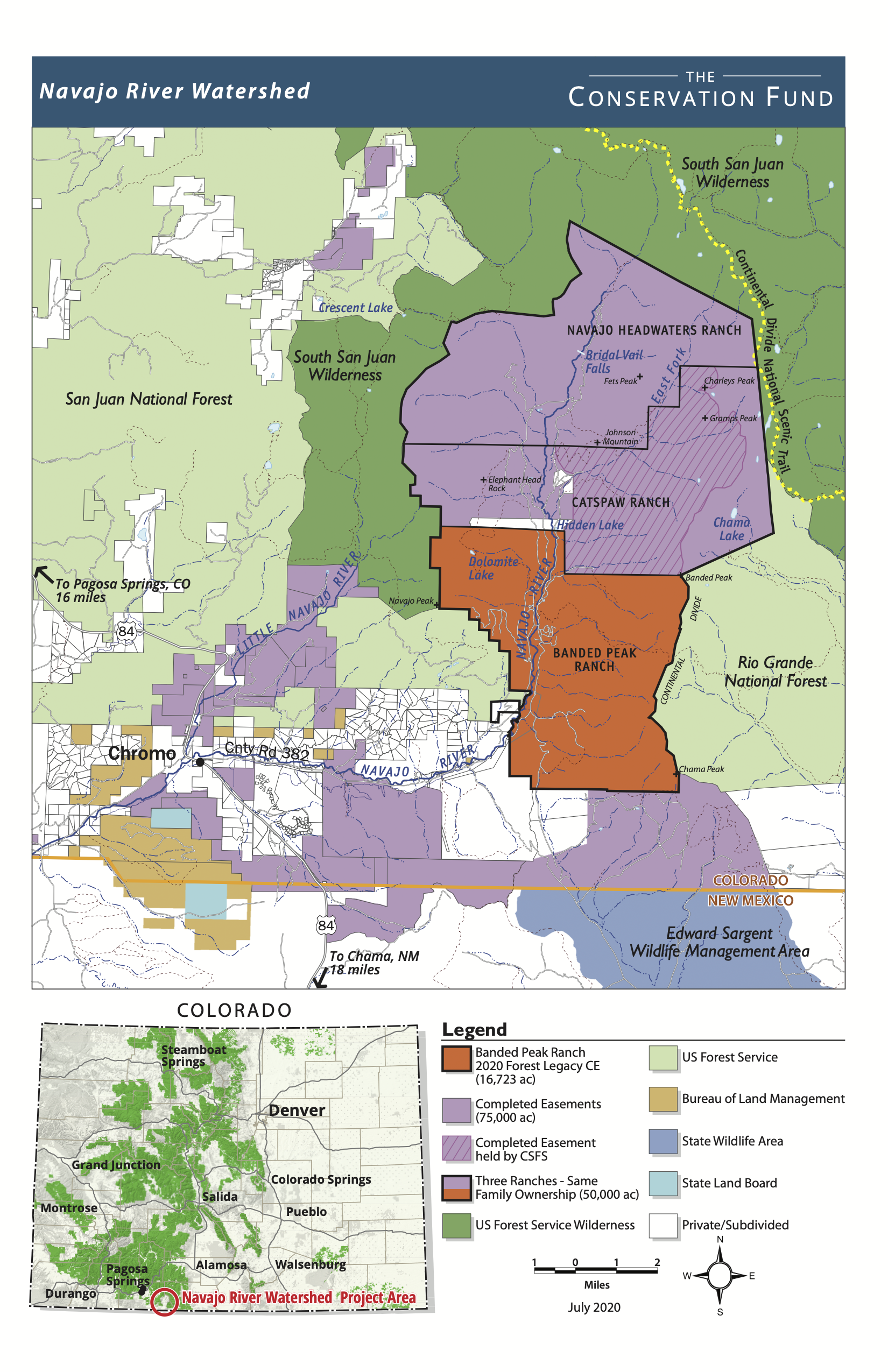
[On July 28, 2020], The Conservation Fund, Colorado State Forest Service and USDA Forest Service announced the permanent protection of the 16,723-acre Banded Peak Ranch in Colorado’s southern San Juan Mountains. The protected land will connect a largely undisturbed forest landscape, prevent development in critical wildlife corridors and conserve an essential watershed that provides water to Colorado and New Mexico communities downstream. The federal Land and Water Conservation Fund played a critical role to permanently safeguard these private forestlands from the threat of development.
Banded Peak Ranch. Photo credit: Christine Quinlan via the Colorado State Forest Service
The completion of a conservation easement on Banded Peak Ranch is the final phase of a 30-year effort by The Conservation Fund in the Navajo River Watershed – protecting a total of 65,000 acres that connect wilderness ranches in the upper reaches of the watershed to conserved working ranches at lower elevations on the Navajo, Little Navajo and East Fork of the San Juan rivers. Permanent protection of these lands is the product of public-private partnerships involving 10 different ranches. Over the years, the Navajo River watershed project area has attracted $37 million from federal, state and private partners, including private foundations, Great Outdoors Colorado (GOCO), the federal Forest Legacy Program, which is managed in Colorado by the Colorado State Forest Service, and private landowner donations.
These privately owned lands are surrounded by some of the most remote, expansive and undisturbed national forest and wilderness lands in Colorado. As the last, large unprotected property in the upper Navajo River watershed, Banded Peak Ranch completes the protection of a wilderness watershed and preserves one of the most important wildlife migration corridors for mule deer and elk in the Rocky Mountain region.
“The headwaters of the Navajo River is one of the wildest and most pristine landscapes we have protected in Colorado. It is a majestic place that has inspired many others to join us in the effort,” said Tom Macy, Western Representative of The Conservation Fund. “If we are going to see grizzlies return to Colorado, it is likely to be here.”
Critical Water Supply, Wildlife Habitat, Working Forests
San Juan River Basin. Graphic credit Wikipedia.
The watershed has critically important benefits for downstream users in Colorado and New Mexico, providing irrigation and drinking water for 1 million people in New Mexico, including 90 percent of Albuquerque’s surface water supply. Protecting Banded Peak safeguards 33 miles of streams on the ranch, including a 5-mile stretch of the Navajo River, along with 850 acres of riparian and wetland habitat.
Banded Peak Ranch – roughly 20 miles southeast of Pagosa Springs – hosts a premier deer and elk hunting program that provides stimulus to the regional economy, while the carefully managed timber operation supports regional wood processing mills. The ranch has been an active participant in the Colorado State Forest Service’s Forest Ag program for two decades and manages its forests with the guidance of a management plan written in conjunction with the agency.
“Our family has been dedicated to land conservation and land stewardship in Colorado and elsewhere for many years,” said Karin Griscom, the family’s representative. “We were privileged to partner with The Conservation Fund, which has diligently worked with us to protect strategic lands and wildlife corridors in the Upper Navajo River watershed over the last 20 years. We also greatly appreciate the help of the U.S. Forest Service and the Colorado State Forest Service, elected officials and especially the Wyss Foundation that were all instrumental in the protection of this legacy ranch.”
‘Myriad of Ecological Values’
Navajo River Watershed map via the Colorado State Forest Service
The Continental Divide National Scenic Trail runs along the eastern border of the family’s properties for approximately 10 miles. Almost completely surrounded by 3.75 million acres of the San Juan National Forest, South San Juan Wilderness and Rio Grande National Forest, protection of the Banded Peak Ranch enhances the adjacent public lands by maintaining healthy forests, critical wetland and riparian areas, and crucial wildlife corridors. Fire modeling shows this ranch is the first line of defense in the watershed for reducing the risk and cost of wildfire.
The conservation easement on Banded Peak Ranch will be held by the Colorado State Forest Service. The two adjacent ranches – Catspaw and Navajo Headwaters – are owned by members of the same family and protected through a series of conservation easements held by the Colorado State Forest Service and Colorado Open Lands. These perpetual easements ensure that the natural richness and ruggedness of these lands will remain largely undisturbed, allowing ranch operations to continue while eliminating future subdivision for residential or commercial development.
“We’re proud to partner with The Conservation Fund, USDA Forest Service and owners of Banded Peak Ranch to conserve the myriad of ecological values on the ranch,” said Mike Lester, State Forester and director of the Colorado State Forest Service. “By protecting Banded Peak and its forests from future development, we’re ensuring the public benefits that these forests provide – from clean air and water to habitat for our iconic wildlife – persist in Colorado for generations to come.”
Support from Colorado’s Congressional Delegation
The protection of Banded Peak Ranch was made possible by $7 million from the USDA Forest Service’s Forest Legacy Program, which is funded by the Land and Water Conservation Fund (LWCF). LWCF uses offshore drilling revenue – not taxpayer dollars – to fund conservation projects across the country. The Great American Outdoors Act, a bill that has passed both the House and Senate and is on its way to the President’s desk for signature, provides full and permanent funding for LWCF and future conservation victories like this one. Colorado’s Congressional delegation, led by U.S. Senators Michael Bennet and Cory Gardner and U.S. Representative Scott Tipton, is united in its support for this program and for the protection of the Banded Peak Ranch.
“The conservation of Banded Peak Ranch is excellent news for southwestern Colorado and a testament to the work of local leaders and landowners, The Conservation Fund, the Colorado State Forest Service and the U.S. Forest Service. Thanks to this decades-long effort, the Navajo River Watershed, and its valuable wildlife habitat, will now be protected for future generations,” said U.S. Senator Michael Bennet. “Without the Land and Water Conservation Fund, projects like this simply wouldn’t be possible. I’m glad to have supported this project throughout the process, and to have secured full funding for LWCF, so that Colorado can continue to invest in public lands, wildlife habitat and our economy.”
“The Land and Water Conservation Fund is the crown jewel of conservation programs and has played a critical role in protecting public lands in Colorado and across the nation,” said U.S. Senator Cory Gardner. “Protecting the Banded Peak Ranch completes 65,000 acres of protected wilderness and watershed which will help wildlife in the area flourish. Additionally, preserving the streams at Banded Peak Ranch ensures that communities downstream, including areas in southwest Colorado, have access to clean water for drinking and irrigation.”
“The addition of the Banded Peak Conservation Easement is a welcome expansion to safeguard critical wildlife habitats in southwestern Colorado,” said U.S. Representative Scott Tipton. “I am proud to have worked to permanently authorize the Land and Water Conservation Fund so that important projects like this will continue benefitting communities in Colorado for years to come.”
Iconic Wildlife
Realizing the opportunity to protect this last piece of the headwaters of the Navajo River, the Wyss Foundation has played an essential role in the Banded Peak Ranch project, providing funds to match the LWCF dollars.
“Thanks to the determination of The Conservation Fund and support from Coloradans demanding more protections for their lands and waters, Banded Peak Ranch will be preserved forever,” said Wyss Foundation President Molly McUsic. “Collectively we must continue taking every opportunity to accelerate our conservation efforts, to safeguard imperiled wildlife and to ameliorate the worst impacts of a changing climate.”
Most of the wildlife species found along southern Colorado’s Continental Divide inhabit the Banded Peak Ranch. Elk, black bear, mountain lion, peregrine falcon, bald eagles, bighorn sheep and many others thrive in the area. Federally threatened Canada lynx also live on the property. The streams on Banded Peak Ranch support the recovery of the San Juan strain of the Colorado cutthroat trout, which was presumed extinct for 100 years, until it was rediscovered on the ranch in 2018. Grizzly bears were once present in this remote wilderness area until the late 1970s. In fact, this was the last place in Colorado to host the iconic and threatened species. Two books were written about the grizzly bears’ presence in this watershed, including Ghost Grizzlies: Does the Great Bear Still Haunt Colorado by David Petersen, and The Lost Grizzlies: A Search for Survivors in the Wilderness of Colorado by Rick Bass.