At its quarterly board meeting in April, the Colorado River District Board of Directors approved $415,876 in Community Funding Partnership grants to support six irrigation companies and districts as part of the newly launched Irrigation Company Financial Sustainability Pilot Grant Opportunity. The pilot program is designed to help irrigation providers assess the condition and financial needs of their systems, prioritize capital improvements, and develop long-term financial plans that support ongoing maintenance and modernization with greater independence and less reliance on uncertain outside funding.
The six approved projects include:
Grand Tunnel Ditch Company, Garfield County: $14,246
Grand Valley Irrigation Company, Mesa County: $137,530
“These projects are great examples of the Community Funding Partnership’s goals of strengthening Western Slope communities by investing in the water infrastructure they depend on,” said Melissa Wills, Community Funding Partnership Program Manager for the Colorado River District. “By helping irrigation providers plan for long-term maintenance, modernization, and financial sustainability, we are supporting West Slope agriculture and local economies, ultimately helping communities prepare for a hotter, drier future.”
Together, the projects support irrigation companies across Delta, Garfield, Mesa, Moffat, and Montrose counties, and a range of ditch sizes, organizational structures, and agricultural communities. Each project will support the development of a capital improvement plan and rate study to help local water providers better understand infrastructure needs, project costs and sustainable funding options. Collectively, the six projects align with the Community Funding Partnership’s goals to support productive agriculture, improve water infrastructure, increase conservation and efficiency, and strengthen communities that rely on local water systems.
The six pilot grants awarded will serve as models for the Irrigation Company Financial Sustainability Pilot Grant Opportunity to collect lessons learned and develop a potential future program that meets the organizational sustainability needs for irrigation companies across the Western Slope. This pilot grant is the first program on the Western Slope to provide dedicated funding for irrigation companies’ infrastructure and financial planning.
Since launching in 2021, the Community Funding Partnership has invested over 32 million dollars in water projects across Western Colorado that support productive agriculture, healthy rivers, watershed health, water quality, infrastructure, conservation and efficiency.
The Colorado River Water Conservation District spans 15 Western Slope counties. Voters across the district are considering a mill-levy increase that would raise the River District’s budget by $5 million, funding a variety of water-related projects. Colorado River District/Courtesy image
With far less snowpack in the high country this year and an anemic runoff forecast, the Uncompahgre Valley is positioned for a terrible irrigation season. Water users association Manager Steve Pope did not mince words.
“This is the worst year on record so far for snowpack. Looking at the fact that it’s pushing 90 degrees outside in March, we aren’t going to be able to expect much of a runoff,” Pope said on Wednesday, one week before water deliveries begin on April 1, ” … There is no good news.”
The Uncompahgre Valley Water Users Association will only be delivering allocations to shareholders of 50% to start, and, if water models remain consistent, will cut delivery to 40%. No pump contracts can be filled this year, although there will be credits for next year for paid accounts. Shareholders who pump directly from an association canal or lateral must register pumps and install meters and regulating valves for the deliveries. As well, people are being asked to reconsider lawns and large-scale landscaping to conserve every drop possible for agriculture…
Runoff projections within the Uncompahgre Basin are worrying. The Colorado River Basin Forecast Center operates SNOTEL sites that measure snowpack and snow water equivalent, the amount of water the snow holds. Ideally, there would be robust snowpack and SWE, as well as weather conditions conducive to slower melt, leading to prolonged runoff. That isn’t the case this year…2026 is on track to turn out even worse than 2002, the leanest water year this century — but even 2002 was bookended with decent water years before and after…Pope said the Colorado River Basin Forecast Center is projecting a 50% chance of the local watershed seeing about 53,000 acre feet of runoff…The water users association can’t really rely on natural flow from the Uncompahgre River this year, Pope said, but he does anticipate enough to fill Ridgway Reservoir. Beyond that, however, “it’s not very promising.” Overall weather conditions compound the problem of so-so snowfall during the winter: it’s been warmer far up in the high country, too. Pope said that at the 12,200-foot elevation Swamp Angel study site maintained by the Silverton-based Center for Snow and Avalanche Studies, it’s only been getting down to a few degrees below freezing at night. (This site had a measured snow water equivalent of 13.4 inches as of March 15.)
“If it’s not freezing at night, there’s nothing to slow the runoff down. They said the dust isn’t as bad this year. That is somewhat of a silver lining. We haven’t had the wind, so the dust isn’t quite as bad,” said Pope. Dust accelerates snowmelt.
The city of Montrose held a groundbreaking Monday marking the start of a major upgradereaking Monday marking the start of a major upgrade to its wastewater treatment plant, a facility that has operated with much of its original equipment since it was built in the 1980s. The project will replace outdated equipment and install new infrastructure to meet current and future water quality standards set by state and federal regulators. Mayor Dave Frank said the plant’s equipment has become difficult to maintain.
“The equipment in our wastewater treatment plant is original to the building of the wastewater treatment plant,” Frank said. “So when something breaks, they’re having to find parts in museums and junkyards in order to repair the equipment that we currently have.”
[…]
The plant treats sanitary sewage in accordance with federal and state standards, releasing treated water back into the Uncompahgre River. The project will replace existing equipment with newer versions and install a tank for biological phosphorus removal. Wastewater Treatment Plant Superintendent Hyrum Webb said the phosphorus removal addition is a proactive step.
“We want to get ahead of the curve on removing phosphorus out of the water before we’re required to by the state,” Webb said. “It gives us some incentive points to help out with future permitting, and it’ll be cheaper now than when the state mandates us to do so.”
Frank said water quality going back into the river is a priority…The project is expected to take approximately 18 months to complete. The total cost is estimated at $40 million, which will be funded through bonds and reserve funds.
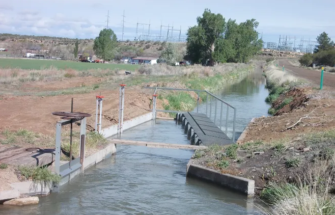
This photo from the Uncompahgre Valley Water Users Association website shows some of its water infrastructure. The association is facing a lawsuit from some of its shareholders who say they aren’t getting a fair share of their irrigation water.
Some shareholders have sued the Uncompahgre Valley Water Users Association, contending they aren’t receiving their fair share of irrigation water and their livelihoods are being harmed…The plaintiffs have been “deprived of consistent and proportional water deliveries during critical irrigation periods since 2022,” which is when new association management took over, the suit says. Over that period plaintiffs also have been deprived of water owed to them based on priority water rights, the suit says.
“These failures have occurred even in years with above-average snowpack and available water. Despite Plaintiffs’ repeated requests to the UVWUA to correct these deficiencies, Plaintiffs continued to receive disproportionate, inconsistent, and insufficient water deliveries during the 2025 irrigation season,” the suit says…The suit says the plaintiffs have experienced problems including weeks without delivery during planting and growing seasons. One plaintiff, Tom Gore, reported going 60 days last year without expected water deliveries. Another, Frank Gilmore, has been able to run only two irrigation pipes simultaneously instead of the normal five and has lost entire cuttings of hay. Delayed irrigation last year left a third of plaintiff Dan Varner’s newly reseeded 34-acre hayfield unproductive, requiring costly reseeding, the suit says. It says the impacts to shareholders have included things such as failed crop rotations, increased cattle feed costs, reduced soil health, and loss of profit from hay and sweet corn yields…
The plaintiffs are shareholders receiving water from the Ironstone Canal system, one of the project’s primary delivery systems. The suit says the association’s delivery practices have deprioritized the Ironstone system and intentionally favored the East Canal system instead. The suit says that last March, Pope admitted in a meeting that the association was intentionally and disproportionately routing water to the East Canal system before delivering to Ironstone System shareholders, contrary to historical practice. It says that in July, Pope also acknowledged that the delivery of 10 cubic feet per second of priority water rights had been mismanaged that irrigation season. Pope said that corrective action would be taken, but as of August, the association had failed to restore full delivery of that water, the suit says. The suit says the association also has failed to regularly maintain association ditches by burning or clearing debris.
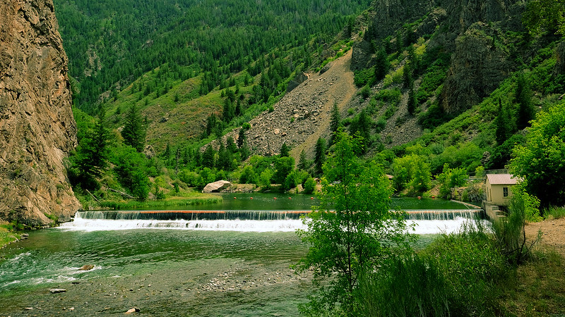
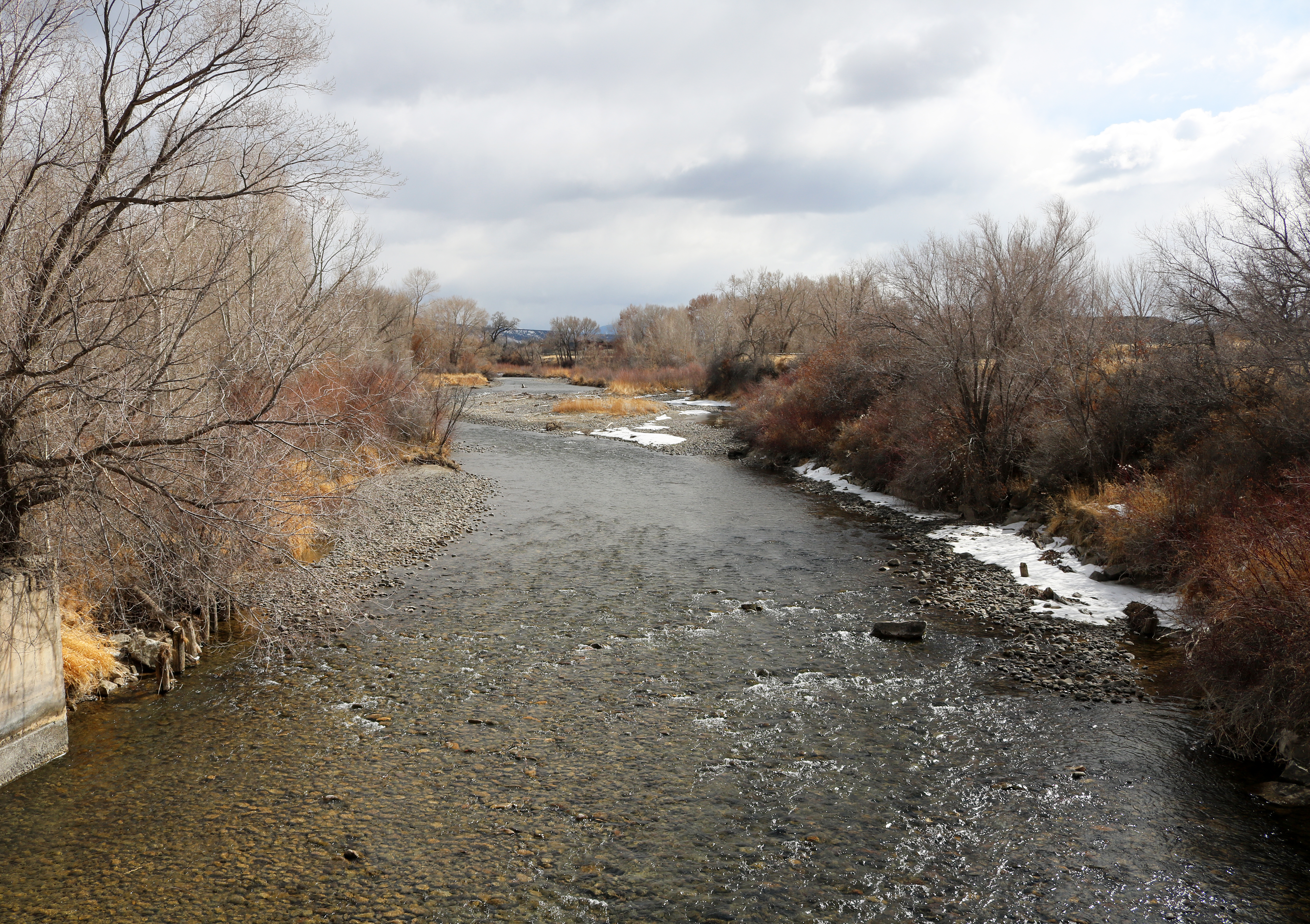
The Uncompahgre River flows from Colorado’s San Juan mountains through the towns of Ouray and Ridgway and then into Ridgway Reservoir, which stores water for farms and households downstream. The river is beautiful, but also troubled; runoff from old mines carries heavy metals into the river, and it is pinched into an unnaturally straight and simple channel as it passes from mountain canyon headwaters into an agricultural valley.
As the river moves through the modified channel, it carves deeper into the valley floor and less frequently spills over its bank. As a result, the local water table has dropped, and riverside trees such as cottonwoods have died, impoverishing this important habitat. Water users on the Ward Ditch at the top of the valley were also struggling with broken-down infrastructure, making it difficult to access and manage water for irrigation. This confluence of challenges created a landscape of opportunity for the Uncompahgre Multi-Benefit Project, which addresses environmental problems along the river and water users’ needs, while also improving water quality and reducing flood risks downstream.
Uncompahgre River, Colorado | Hannah Holm
The Project, managed by American Rivers, took an integrated approach to restoring a one-mile stretch of the river, which included replacing and stabilizing the Ward Ditch diversion, notching a historic berm to reconnect the river to its floodplain, and placing rock structures in the river that both protect against bank erosion and improve fish habitat. Meanwhile, ditch and field improvements make it easier to spread water across the land for agriculture and re-establish native vegetation.
Photo credit: American Rivers
Photo credit: American Rivers
In addition to the direct benefits this project delivers for on-site habitat and landowners, the enhanced ability of the river to spread out on its floodplain, both through the ditch diversion and natural processes, also provides downstream benefits. As the water slows and spreads across the floodplain during high flows, its destructive power to erode banks and damage infrastructure downstream is diminished. The same dynamics enable pollutants and sediment from upstream abandoned mines or potential wildfires to settle out before the river flows into the downstream reservoir.
Uncompahgre River, Colorado | Hannah Holm
With construction wrapping up in November 2025, the transformation of this stretch of river and its adjacent floodplain is nearly complete. Fields of flowers and fresh willow plantings are replacing invasive species and dead cottonwoods, and new pools, sandbars, and riffles are providing instream habitat, complementing other organizations’ work to remediate old mines upstream. As a bonus, when the water level is right, the reach has become an inviting run for skilled whitewater boaters.
For the most part, President Donald Trump has done everything we feared the candidate would do and then some: following Project 2025 to a T, gutting environmental and public health protections, shredding the First Amendment (to the point of even losing Tucker Carlson), threatening political opponents, and generally embracing authoritarianism.
But when it comes to public lands, there is actually one act we expected the administration to do shortly after the inauguration, but that it hasn’t yet attempted: Shrinking or eliminating national monuments, especially those designated during the Clinton, Obama, and Biden administrations. Even after Trump’s Justice Department opined (wrongly, I’d say) that the Antiquities Act authorizes a president to shrink or revoke national monuments, the administration didn’t actually do it.
I suspect this is because they realize how deeply unpopular that would be. Sure, Trump’s first-term shrinkage of Grand Staircase-Escalante and Bears Ears national monuments may have garnered some support from a handful of Utah right-wingers, but they’d be behind him regardless. Meanwhile, it pissed off a lot of Americans who value public lands but might otherwise support Trump’s policies.
That’s not to say the national monuments are safe. It’s just that the administration seems to be intent, for now, to outsource their destruction to their friends in Congress. The House Republicans’ proposed budget, for example, would zero out funding for GSENM’s new management plan — a de facto shrinkage.
And now, Rep. Paul Gosar, a MAGA Republican from Arizona, has introduced bills that would nullify Baaj Nwaavjo I’tah Kukveni – Ancestral Footprints of the Grand Canyon National Monument and the Ironwood Forest National Monument northwest of Tucson. The former blocks new mining claims in an area that has been targeted for uranium extraction. And the latter, established by Bill Clinton in 2000, covers a 189,713-acre swath of ecologically rich Sonoran Desert near the gaping wound known as the Asarco Silver Bell copper mine. The national monument designation blocked new mining claims.
Interestingly enough, neither of the national monuments are in Gosar’s district, which covers the heavily Republican western edge of the state, so he won’t suffer from voter blowback if the legislation succeeds.
⛏️ Mining Monitor ⛏️
Congressional Republicans, with some Democratic support, are again trying to pass legislation that would allow mining companies to dump their waste on public lands.
The Mining Regulatory Clarity Act of 2025, introduced by Rep. Mark Amodei, R-Nevada, made it through the House Natural Resources Committee this week on a 25-17 vote. It would tweak the 1872 Mining Law to ensure that mining companies can store tailings and other mining-related waste on public land mining claims that aren’t valid, meaning the claimant has not proven that the parcels contain valuable minerals. This was actually the norm for decades until 2022, when a federal judge ruled that the proposed Rosemont copper mine in Arizona could not store its tailings and waste rock on public land. That ruling was followed by a similar one in 2023, leading mining state politicians from both parties to try to restore the pre-Rosemont Decision rules.
The bill would supplement Trump’s executive order from March invoking the Defense Production Act to expedite mining on public lands, and his “emergency” order that fast-tracks mining and energy permitting on public lands.
***
Photo credit: Jonathan P. Thompson/The Land Desk
IsoEnergy, the company that owns the controversial Daneros Mine just outside Bears Ears National Monument and the Tony M Mine,plans to begin exploratory drilling at its Flatiron claims in Utah’s Henry Mountain uranium district. Last year, the Canada-based company staked a whopping 370 lode claims on federal land. Along with two Utah state leases, this adds up to about 8,800 acres south-southwest of Mt. Hillers.
🛢️ Hydrocarbon Hoedown
A peer-reviewed study out of UCLA recently found that pregnant women living near the Aliso Canyon natural gas storage facility in Los Angeles during the sustained blowout of 2015 experienced more adverse birth outcomes than expected. Specifically, the prevalence of low birthweight was 45% to 100% higher than those living outside the affected area. This should concern not only folks living near Aliso Canyon (which is still operational), but also anyone who lives near an oil and gas well or other facility.
Aliso Canyon is a depleted oil field in the hills of the Santa Susana Mountains in northern LA. Southern California Gas pipes in natural gas, pumps it into the oil field, and stores up to 84 billion cubic feet of the fuel there. In October 2015, one of the wells blew out and for the next 112 days spewed a total of about 109,000 metric tons of methane, a potent greenhouse gas and the main ingredient of natural gas.
That’s bad. But also mixed into the toxic soup that erupted from the field were other compounds such as mercaptans including tetrahydrothiophene and t-butyl mercaptan, sulfides, n-hexane, styrene, toluene, and benzene. All really nasty stuff that you don’t want in your air, and that is often emitted by oil and gas wells. The authors write:
“The emissions of BTEX and other HAP compounds are of particular concern as even at levels below health benchmarks they have been linked to health effects, including neurological, respiratory, and developmental effects.”
That appears to have been the case with the Aliso Canyon blowout, where “low birth weight and term low birth weight was higher than expected among women living in the affected area whose late pregnancy overlapped with the disaster.”
It’s simply more confirmation that fossil fuel development and consumption can take a big toll on the environment, the climate, and the people who live in or near the oil and gas patch or associated infrastructure. And that limits on methane emissions are important, even if you don’t care about climate change.
***
Long-time Land Desk readers might remember my story about the Horseshoe Gallup oil and gas field and sacrifice zone in northwestern New Mexico. I wrote about how the area had been ravaged by years of drilling and largely unfettered development, how the wells had been sold or handed off to increasingly irresponsible and slipshod companies as they were depleted, and how that had left dozens of abandoned facilities, oozing and seeping nasty stuff, but were not cleaned up because state and federal regulators still considered them to be “active.”
The field is still there, along with most of the abandoned wells. But Capital & Main’s Jerry Redfern reports that some of the worst sites, including the NE Hogback 53, are being cleaned up. Well, sort of. The extensive reclamation of the well and the tank battery was started, only to be halted in May at the end of the state’s fiscal year. It resumed in July, and is expected to cost about $650,000.
This highlights the need for stronger enforcement and, most importantly, adequate reclamation bond requirements. At prices like that, cleaning up just the Horseshoe Gallup could cost tens of millions of dollars, and the taxpayer will be left to shoulder most of the bill.
🥵 Aridification Watch 🐫
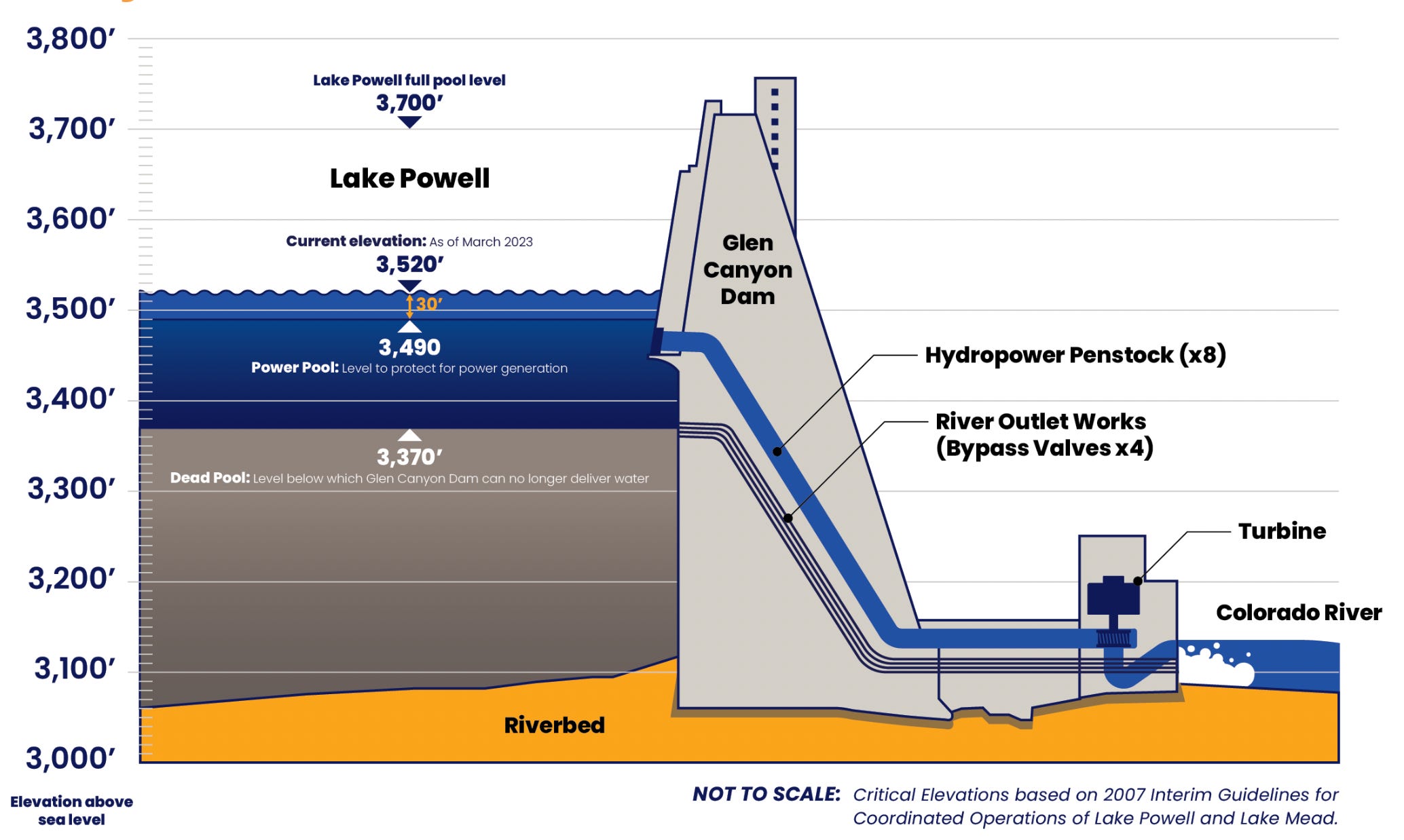
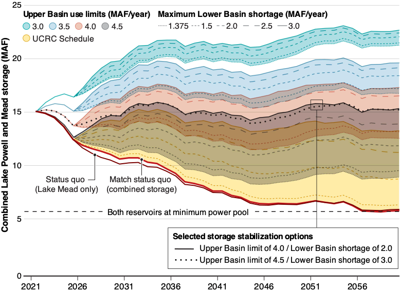
Clarification: In Tuesday’s dispatch on the Colorado River and Lake Powell, I wrote that another dry winter would put “… the elevation of Lake Powell at 3,500 feet by this time next year. And, due to the infrastructure’s limitations, Glen Canyon Dam would have to be operated as a ‘run of the river’ facility.” That probably needs a bit more explanation.
One smart reader pointed out that even after the surface level of Lake Powell drops below minimum power pool, or 3,490 feet in elevation, the dam can still release up to 15,000 cfs from its river outlets. Technically, managers would not be forced to go to run of the river until the surface level dropped below 3,370 feet, which is known as “dead pool.”
However, the Bureau of Reclamation is very wary of relying on the river outlets, because they weren’t designed for long-term use and could fail under those circumstances. So, BoR is intent on keeping the water levels above minimum power pool so that all releases can go through the penstocks and the hydroelectric turbines. “In effect,” the authors of the paper wrote, “at least for the short term, the engineering and safety issues associated with the ability to release water through Glen Canyon Dam mean that the amount of water actually available for release from Lake Powell is only that which exists above elevation 3500 feet.”
So, as long as this is the case, the BoR will need to go to run of the river as soon as the elevation drops to 3,500 feet. I hope that helps clear things up!
🗺️ Messing with Maps 🧭
Today’s map is less about the map than it is about the publication it comes from, the USGS’s Guidebook of the Western United States Part E. the Denver & Rio Grande Western Route, published in 1922. This thing is super cool, and super detailed (it’s 384 pages long). It’s got some great photos and maps, like this one (click on the image to see it in larger size on the website).
Besides having a cool, hand drawn style, this map struck me because it was made prior to the reservoirs on the Gunnison River. And it shows how the railroad tracks used to go into the Black Canyon at Cimarron and continue along the river all the way to Gunnison (most of that section is now under water). I suppose I should have known that was where the tracks went, but it never really occurred to me before. Credit: USGS
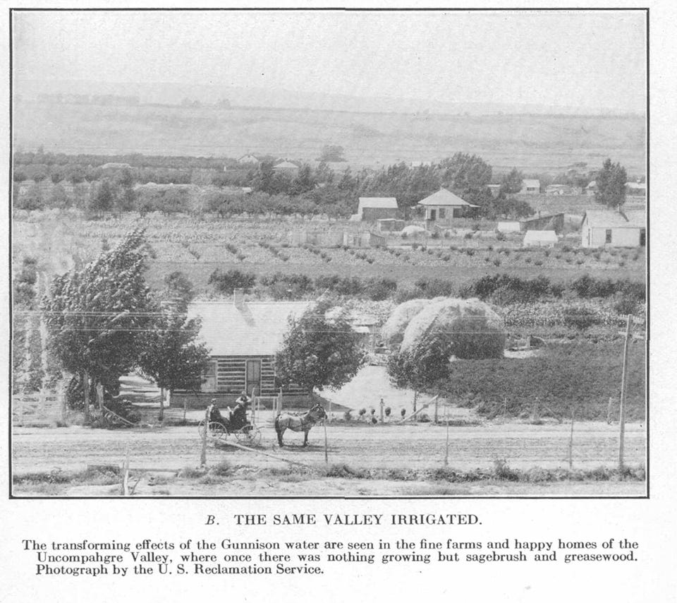
Related to that map were these two photos illustrating the miracle of irrigation.
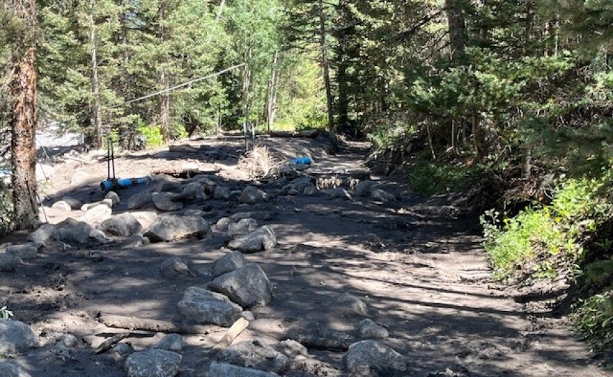
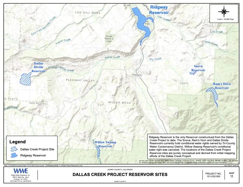
40 miles from Ridgway, high in the San Juans a water diversion structure diverts water into a pipe that then fills the storage reservoir for Ridgway’s water treatment plant. When a massive storm tore through the drainage in August 2024, it destroyed the town’s main water diversion system. More than a year later, construction is finally underway on a new, more resilient setup to keep clean water flowing. Town Manager Preston Neill says the storm caused an “unbelievable amount of water” to surge down Beaver Creek. The force of the water filled the diversion point and part of the Ridgway ditch with mud, boulders, and debris. The creek widened, undercut the diversion, and rerouted itself below the level of the town’s intake infrastructure, making it impossible for water to reach the town’s storage reservoir. Town staff said it was the most severe change to the creek in over 40 years.
“The Creek and the Ridgway ditch are no longer aligned,” Neill said in an interview with KVNF. “That just became buried in feet of boulders and mud and other debris.”
The town is now building an entirely new diversion system designed to withstand future high-flow events. Construction began in mid-August 2025, almost exactly one year after the flood. Neill says that timeline reflects the complex process of coordinating with state and federal agencies and securing funding. The bulk of the estimated $3 million project is being covered by outside sources. The Natural Resources Conservation Service is expected to reimburse up to 75% of construction costs, with the rest split betweenother agencies (both state and federal) and the Town of Ridgway. All engineering and pre-construction work has been reimbursed at 100% by federal funds.
Click the link to read the article on the KVNF website (Brody Wilson):
April 29, 2025
The Colorado River is the lifeblood of the American Southwest. Forty million people depend on it — not just here in Colorado, but in cities like Phoenix, Las Vegas, and Los Angeles.
Here on the Western Slope, we don’t always feel directly connected to the Colorado River. After all, we live in the Gunnison Basin — a different watershed, right?
Not quite. The Gunnison River contributes about 17% of the Colorado River’s total annual flow. So any decision made about the Colorado River’s future directly affects us — how much water we can use, when, and for what purpose. For decades, the river has been in a slow-moving crisis. Climate change, explosive population growth, and overallocation have pushed the system to the brink. In 2022, the river’s two main reservoirs — Lake Powell and Lake Mead — reached such low levels that hydropower turbines at Glen Canyon Dam were nearly shut down and dam operators were near “dead-pool” where water would no longer be able to pass through the dam. But today, nearly three years later, the system isn’t bouncing back. Andy Mueller, General Manager of the Colorado River District, has a blunt message: the Colorado River is carrying less water than it used to, and if we don’t change course, the future of agriculture, recreation, and the our way of life across the Western Slope could be at risk.
“The average temperature in March has gone up 4.2 degrees Fahrenheit,” Mueller told the crowd in Ridgway. “And for every 1 degree of warming, streamflow drops by 3 to 5 percent. We’re looking at a 20% decline right here in the Uncompahgre Valley over the last 125 years.”
These trends are part of a long-term warming and drying pattern. Less snow is falling, and what does fall melts earlier. That means less water reaches our rivers — and more of it is lost to evaporation or absorbed by plants growing in longer, hotter seasons.
In 1922, Federal and State representatives met for the Colorado River Compact Commission in Santa Fe, New Mexico. Among the attendees were Arthur P. Davis, Director of Reclamation Service, and Herbert Hoover, who at the time, was the Secretary of Commerce. Photo taken November 24, 1922. USBR photo.
To understand what’s happening now, you have to go back to 1922. That’s when the seven states in the Colorado River Basin signed a compact to divide the river’s water. Colorado, New Mexico, Utah, and Wyoming became the “Upper Basin.” California, Arizona, and Nevada formed the “Lower Basin.” Each side was promised 7.5 million acre-feet of water per year. But there was a problem: the river wasn’t carrying that much water — and certainly doesn’t now. For decades, this over-allocation was masked by big reservoirs like Lake Powell and Lake Mead. But as the drought continues, those buffers have disappeared. In 2007, the states and federal government adopted a temporary fix: interim guidelines to manage the system during dry years. Those guidelines are set to expire in 2026. New rules must be negotiated now — and the clock is ticking.
“There’s a lot of confusion out there,” Mueller said. “People talk about renegotiating the Compact — but that’s not what’s happening. The Compact isn’t being touched. What’s being negotiated are the guidelines for how Powell and Mead are operated — especially in times of shortage.”
Grand opening of the Gunnison Tunnel in Colorado 1909. Photo credit USBR.
From email from Reclamation (Erik Knight):
March 17, 2025
Releases from the Aspinall Unit will be increased from 700 cfs to 1200 cfs Tuesday, March 18th. Releases are being increased to coincide with the start of diversions at the Gunnison Tunnel.
Flows in the lower Gunnison River are currently above the baseflow target of 1050 cfs. After this release change river flows are expected to remain above the baseflow target for the foreseeable future.
Pursuant to the Aspinall Unit Operations Record of Decision (ROD), the baseflow target in the lower Gunnison River, as measured at the Whitewater gage, is 1050 cfs for March through May.
Currently, Gunnison Tunnel diversions are 0 cfs and flows in the Gunnison River through the Black Canyon are around 650 cfs. After this release change Gunnison Tunnel diversions will be 450 cfs and flows in the Gunnison River through the Black Canyon will be around 700 cfs. Current flow information is obtained from provisional data that may undergo revision subsequent to review.
This scheduled release change is subject to changes in river flows and weather conditions. For questions or concerns regarding these operations contact:
The Colorado River District’s State of the River meetings are a spring tradition in Western Colorado, bringing communities together to discuss the most pressing water issues facing our region. These free public events provide valuable insights into river forecasts, local water projects, and key challenges impacting West Slope water users.
Eleven meetings are planned across the Western Slope; see the list below. These events offer an opportunity to hear directly from water experts and better understand the factors shaping the future of our rivers. A complimentary light dinner will be provided, and all events include a Q&A session to address your questions and concerns.
While each program is tailored to reflect local water priorities, key topics at all events will include:
River flow forecasts
Updates on the Colorado River system
Local water projects and priorities
Current challenges facing Western Colorado water users
Shoshone Water Rights Preservation Project updates
If there are specific local issues or projects you would like to see highlighted, please include that information in your registration.
Registration is required, but attendance and dinner are free. We encourage all community members—whether deeply involved in water issues or just beginning to engage—to join us and participate in this important conversation.
Secure your spot today and be part of shaping the future of water in Western Colorado.
Click each event below to register!
Agendas will be posted for each meeting once they are finalized.
Well, with the fate of constitution democracy in the courts where we know the mills grind slowly (as opposed to the grinders who break things quickly); and with the money frozen for farmers doing well by doing good in water conservation; and neither white smoke nor black smoke arising from the chimneys of the enclaves trying to envision the next decade or so for the Colorado River – I’ll take a break from my wonkish efforts to think outside the box, to remember a friend and mentor, and friend of the River, who thought outside the box often in the last half of the 20th century.
The cantankerous Colorado River water community recently lost a valued member, L. Richard Bratton, a water attorney in the Upper Gunnison River Basin from 1958 till his death January 28.
Dick Bratton’s scope of influence went beyond the Upper Gunnison mountain valleys, however; he was a creative thinker who never met anyone he could not talk to – or listen to, or work with. A born “connector,” he became an active player in events on the cusp of major changes in the development of water in the entire Upper Basin of the Colorado River.
Born in 1932 and raised in Salida, Dick Bratton came to Gunnison to attend Western State College, then went to the University of Colorado Law School. While at school in Gunnison, he had met Ed Dutcher, a somewhat legendary West Slope water attorney. Shortly after Bratton completed law school, Dutcher invited him to join his firm in 1958.
Aspinall Unit dams
Bratton joined Dutcher’s firm that year – and in 1959, the Colorado River Storage Project (CRSP) came to the Upper Gunnison River Valley in a big way, with Congressional approval of funding for CRSP’s Curencanti Project (Blue Mesa, Morrow Point and Crystal Dams, now renamed the Wayne Aspinall Unit), and he found himself plunged into all of the ongoing and emerging challenges faced by small communities with agrarian roots in an urbanizing and industrializing world.
The first challenge was Theodore Roosevelt’s conservation vision. The “Father of American Conservation” had a different view of conservation than most of us have today; to him and his philosopher sidekick Gifford Pinchot, conservation meant first the orderly development of resources otherwise wasted – like the Colorado River pouring itself into the sea in a two-month uncontrolled and mostly unused flood of snowmelt. And when it came to what should be developed and by and for whom, their rule was “the greatest good for the greatest number,” with “for the longest time” sometimes remembered, sometimes not.
In the Upper Gunnison, the Bureau of Reclamation had chosen the Curecanti Reservoir site not to benefit the small ranches and farms of the Upper Gunnison valleys, in accord with their original Rooseveltian mission. It was chosen because it was a great site for a major reservoir in a regional water development for four states that were paranoid over their obligation to make sure a set amount of water passed on to the three more populous states below the Colorado River canyons. The greatest good for the greatest number.
The Curecanti Reservoir as originally proposed, however, would have backed 2.5 million acre-feet (maf) of water almost up to the city limits of Gunnison, with the shallow end exposing major mudflats every summer as the reservoir was drawn down, and the prevailing westerlies would have turned Gunnison into a dust bowl. Bratton’s partner and mentor Ed Dutcher had invested much of his career into opposing this local sacrifice for the greatest good for the greatest number – not just standard NIMBYism; the community was fighting for its life, and also for the life of two small towns that would be inundated along with 30 miles of legendary fishing stream, 23 small river resorts, and 6,000 acres of ranchland.
After much noisy negotiation with the Bureau of Reclamation for Dutcher and his “Committee of 39,” the Bureau dropped the reservoir size to just under one million acre-feet, saving Gunnison from the dust inundation, but still losing the two smaller towns and their economic activities – and the great fishing.
Being sensitive to the cost the project was imposing on the ranchers and farmers that the Bureau was actually created to serve, however, an “Upper Gunnison River Project” with seveeral small reservoirs was included as a future participating project in the CRSP Act, to be paid for partially by the revenues from the hydroelectric plant on the three largest CRSP dams: Glen Canyon, Flaming Gorge and the Curecanti Unit.
So one of Bratton’s first jobs in Gunnison was helping talk the people of the valley into taxing themselves a little to create an Upper Gunnison River Water Conservancy District under state law, both to help the Bureau lobby for project funding in Washington, and to nudge and harass the Bureau into getting project planning and execution done. Creating the Conservancy was accomplished in an election in 1959, a busy year for Dutcher and Bratton.
In 1961 Dutcher was appointed to a judgeship, and Bratton took over the law firm. That same year, the Bureau opened an office in Gunnison, and began the preliminary work for the Curecanti Project – clearing the land of trees, relocating roads, and buying out all of the human occupants, an unpleasant and depressing process in the valley. The “greatest good for the greatest number” rule, applied in many areas other than conservation, has nothing in the formula for the “lesser numbers” – probably one source of our current urban-rural troubles.
As construction proceeded on the Curecanti dams, though, a “big pivot” in the way the entire nation perceived the American West was becoming unignorable. The Bureau of Reclamation had depended on the willingness of the American people to continue investing in the “reclaiming” of arid lands to create more of the iconic “family farms” and to otherwise further the development of raw resources to feed the people and industries of an increasingly urbanized and industrialized economy. But the increasingly urbanized, industrialized – and after the Second War, increasingly mobilized – American people were enjoying a rising standard of living that included more time for recreation – paid vacations! – and “their” western public lands were increasingly perceived not as a resource hinterland, but as a vacation paradise, to be kept as pure and pristine as possible with millions of people trampling through.
On Bratton’s home front, the Crested Butte Ski Resort also opened in 1961 upvalley, forcing the beginning of a transition in the Upper Gunnison’s self-perception as part of the mining, farming and ranching “working west,” as opposed to a service sector serving visitors to the great western playground. “Conservation” was swinging from the Rooseveltian orderly development of otherwise “wasted” resources toward conservation as careful guarding of the West’s resources, including preservation of its residual wild magnificence, Wallace Stegner’s “society to match its scenery.”
Bratton himself was the son of a “working west” family, with a couple generations before him in Colorado engaged in mining and mining-related economic activities. But like the political creator of the Colorado River Storage Project, West Slope Congressman Wayne Aspinall, Bratton could see where things were going, and worked to make the transition at home as non-disruptive as possible for the “Old West” yielding to the “New West.” (Aspinall’s CRSP Act included provisions for recreational facilities around the major dam sites – but also provisions for a number of “Old West” valley-scale projects that could not meet cost-benefit analyses on their own without assistance from hydropower revenues.)
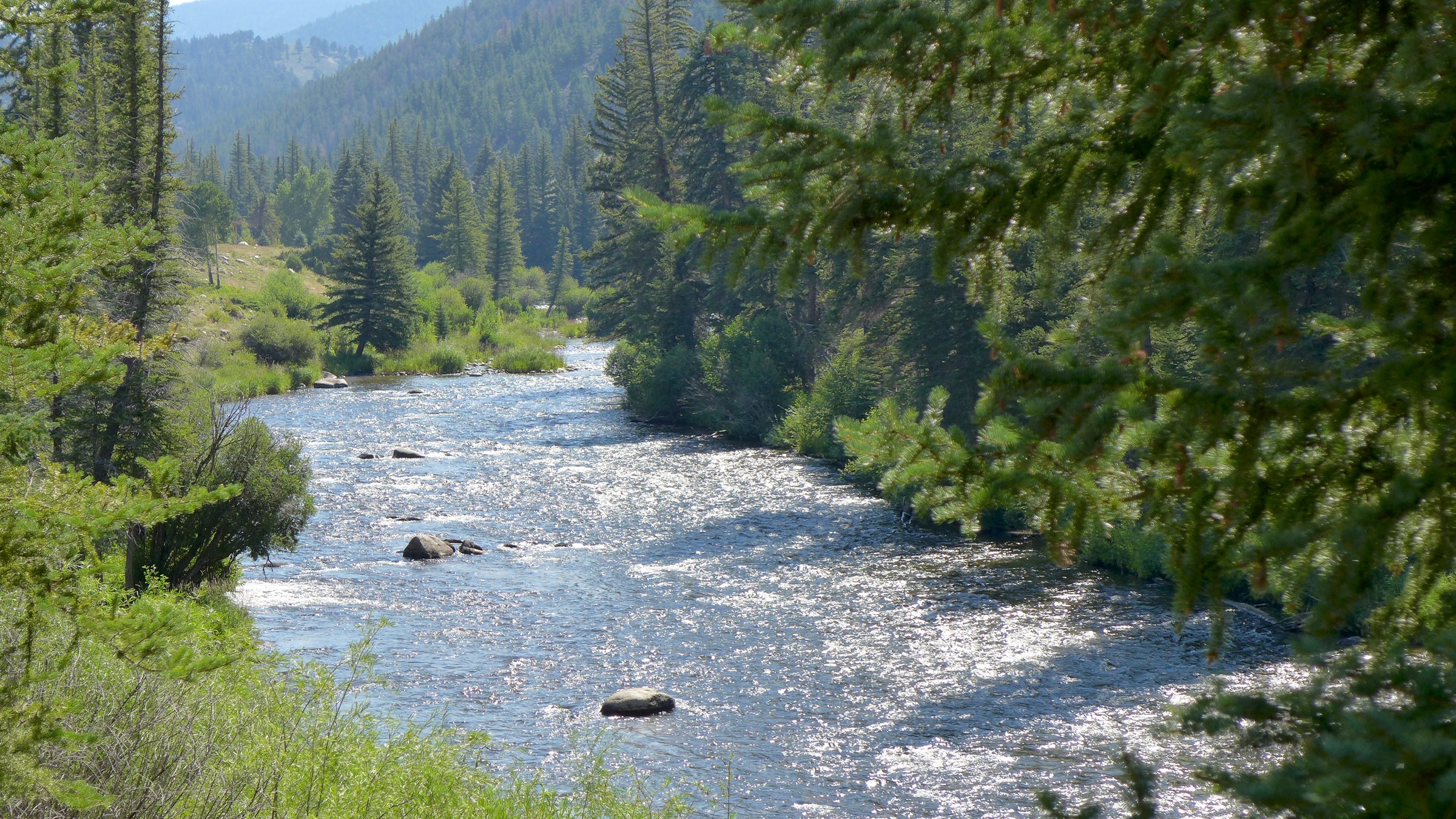
The Taylor River, jewel of the Gunnison River basin. Photo: Brent Gardner-Smith/Aspen Journalism
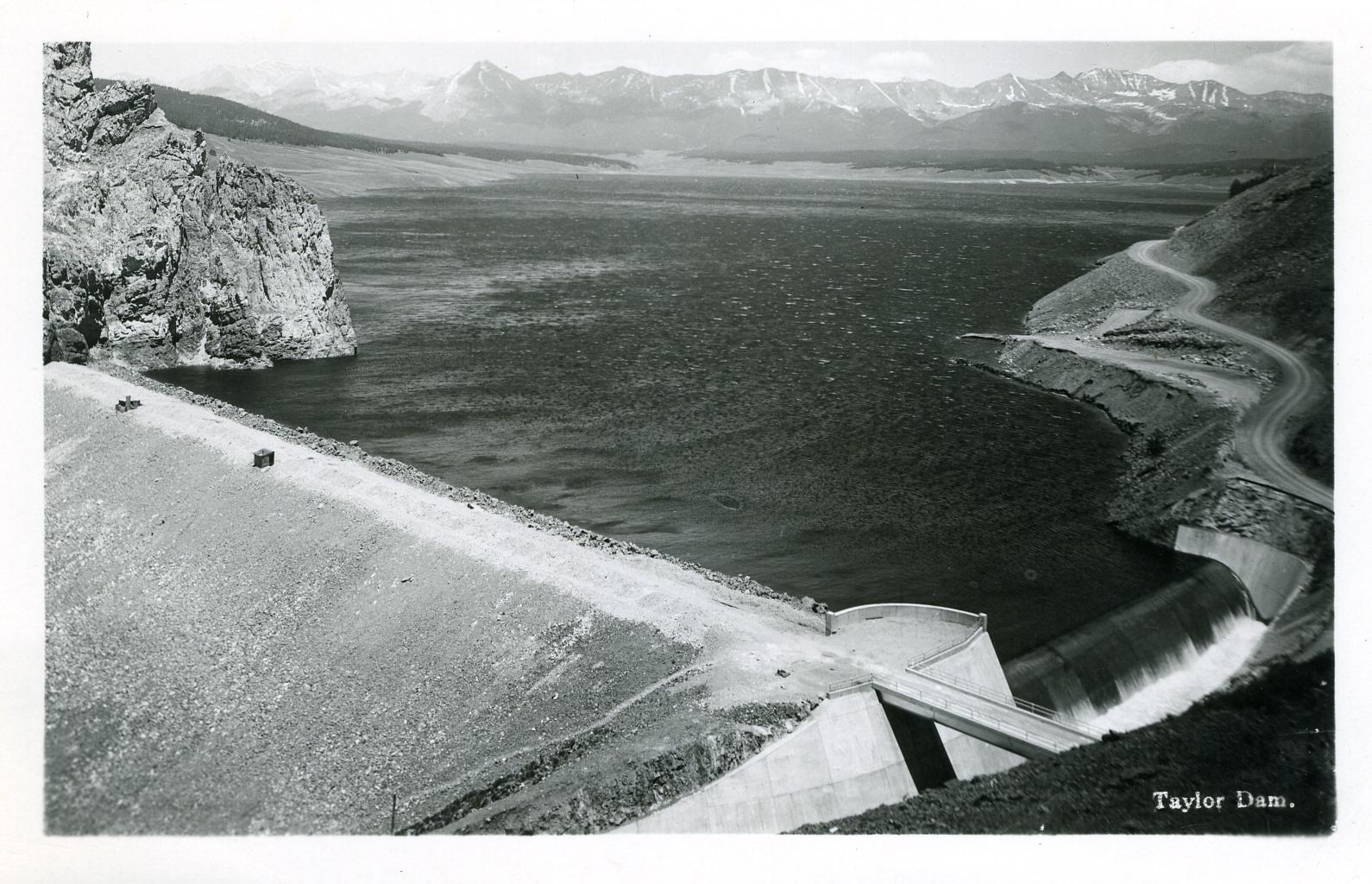
The creative quality of Bratton’s work in that transition is probably best shown in the story of the resurrection of the Taylor River. The Taylor River collected runoff from some of the highest and snowiest peaks of the Continental Divide and came down to the Gunnison River through 25 miles of canyons – a beautiful mountain river with a reputation among “anglers” (don’t even say “bait”) as a world-class fishery, even in the early 20th century.
But in the 1930s, the Bureau put a dam at the head of the canyons to store late-season water for farmers in the Uncompaghre River valley, more than a hundred miles downriver at the receiving end of the Gunnison Tunnel, the Bureau’s first big transbasin water project. That project to make life better for distant farmers effectively killed the Taylor and its aquatic life as a river, reversing its natural wet and dry cycles and turning it into an irrigation canal that ran at the will of the Bureau. This was a great loss to the people of the Upper Gunnison, who knew that the best time for fishing was after work anyway. The loss of the Taylor was their first lesson in what the greater good for a greater number meant for the lesser number.
And the Curecanti Project was their second lesson, inundating another twenty-some miles of world-class fishery, along with two small towns and a fishing-resort community that made decent livings from the river. But the Upper Gunnison farmers and ranchers held out hope that, once the Curecanti Unit was in place to play its role in the larger world of Colorado River Basin policy and politics, the Bureau would at least fulfill its promise and begin work on the Upper Gunnison River Project to give them a little help with late-season water.
But just in the decade-and-a-half from the difficult passage of the CRSP Act in 1956 to the completion of the Curecanti Project, public support for expensive irrigation projects to develop western lands basically dried up, replaced by active opposition to anything disturbing the natural beauty and magnificence of The West. It became obvious to the Upper Gunnison Conservancy board and Bratton – attorney on retainer to the board for its first 40 years – that there would be no federal funds for an Upper Gunnison River Project.
But Bratton – a convener and collaborator who managed to maintain good working relationships even with opponents – started to play on the Bureau’s guilt at not being able to fulfill their promise to the people of the Upper Gunnison. He found a willing collaborator in Bob Jennings, a Bureau manager in the West Slope office. Together, they devised a plan whereby the Bureau would let the Uncompaghre Valley Water Users Association store their Taylor Reservoir water in the Blue Mesa Reservoir – at least a day closer to where the water would be used. Then the water could be moved from the Taylor Reservoir down to Blue Mesa from in a schedule more in tune with the natural flow of a river. Maybe the Bureau could not create small upstream reservoirs for the “Old West” agrarian economy, but it could facilitate the resurrection of a beautiful river for the “New West” economy taking shape (and Old West workers who liked to fish).
This was accomplished with a 1975 agreement among the Uncompahgre Valley farmers, the Colorado River Water Conservation District, the Upper Gunnison River Water Conservancy, and the Bureau. The Bureau would manage the “new” river, but with input from the other three parties – input that begins each spring with a meeting of an Upper Gunnison River “Local Users Group”: representatives from Taylor River irrigators, whitewater recreation businesses, Taylor Reservoir flatwater businesses, anglers, and riparian residents. This group sits down with projections for the summer runoff, and compile suggestions for the Bureau on the operation of the Taylor River that will meet all their needs more or less (and being sure to get the Uncompahgre farmers’ water down to Blue Mesa storage in a timely way). The Bureau and other parties can override their recommendations, but seldom need to. And the Taylor is a beautiful mountain river again – “unnatural” only in being democratically operated by all of its Old West and New West users.
Bratton did not stop there. He led the Upper Gunnison River Water Conservancy District through the process of filing for rights on a secondfill of the Taylor Reservoir. Taylor Park above the reservoir gathers on average half again the 110,000 af needed for the Uncompahgre users first fill. Any water collected in a second fill would be left in the river, for wildlife and other environmental benefits downriver – a right consistent with Colorado’s 1973 instream flow law, to sustain the aquatic and riparian environment “to a reasonable degree.” This water right, inconceivable before the 1970s and NEPA awarenesss, was granted in 1990 – just in time to help thwart a proposal for a transmountain diversion to the Front Range from the adjacent Union Park.
Even then, Bratton was not yet done playing on Bureau guilt for imposing the Curecanti Unit on the Upper Gunnison with no compensatory project for the local water users – even though the Upper Gunnison community generates a lot of economic activity from the Curecanti National Recreation Area around Blue Mesa Reservoir. Early in the 21st century, Bratton wanted to develop some ranchland he owned adjacent to the City of Gunnison, with a tributary of the Gunnison River running through it. This development was not received by local residents with any great enthusiasm.
But Bratton remembered a ‘handshake agreement’ with the Bureau from the Curecanti construction era, that the Bureau would replace the great sport fishery the reservoir would inundate with some good public access fishing streams elsewhere in the basin. So rather than developing a standard golf-course-rimmed-with-expensive-homes development, Bratton reminded the Bureau of its promise, and sold it the stream corridor through his land for public access, to be managed by Colorado Parks and Wildlife.
Bratton was also deeply committed to his alma mater, Western State College (now Western Colorado University). In 1975 – obviously a busy year in his life – he orchestrated the creation of the Western State College Foundation, with bequests from former Colorado Governor Dan Thornton and his wife Jessie, valley ranchers; the Foundation continues as an important support for program development at the University.
The following year, 1976, he collaborated with Western history professor Duane Vandenbusche on a water education course. The next year, 1977, that evolved into the “Western Water Workshop,” to which Bratton invited an incredible lineup of speakers, including – in the same room – longtime West Slope Congressman Wayne Aspinall, Denver Water’s longtime chief counsel and bitter West Slope adversary Glenn Saunders, Assistant Bureau of Reclamation Director Cliff Barrett, former Governor John Vanderhoof, and a number of other luminaries of the “water buffalo era.” Your author was privileged to sneak into those summer sessions – one of the most memorable of which was Bureau man Cliff Barrett trying to suss out the implications of President Carter’s recently released “hit list,” a list of water projects, including a number of CRSP projects, that did not meet a new cost-benefit analysis – essentially the official end of the era of federally-funded western water development.
The Western Water Workshop continued for forty years; a place where East Slope and West Slope, Old West and New West participants could gather for a couple days of off-the-record escape from the physical and cultural heat of the cities in the summer. I sserved as director of the Workshop for six year after the turn of the century until I retired from Western, and I found Dick Bratton to still be a great resource and idea person. At that time he had been appointed by President G. W. Bush to be the federal representative on the Upper Colorado River Commission. He once took pains to save my Water Workshop job when I had inadvertently offended one of the old “water buffalo” with a couple invitees to a session; Bratton reminded his old friend that the Workshop promised “the presentation of all reasonable points of view.”
The reader may feel this article is more a history lesson than the remembrance of a man. (A full obituary can be found in the Feburary 6 Gunnison Country Times – www.gunnisontimes.com) But it is my feeling that some people cannot be understood outside of the history they are part of, and Dick Bratton was such a person. Like his friend Wayne Aspinall, he tried to help Colorado’s West Slope (and the larger intermountain West) negotiate the difficult, inevitable, and ongoing transition from the “Old West working economy” to the “New West amenity economy.” His heart may have been more with the former, but he became at home with the latter because, basically, he was at home in the world, whatever it was, and enjoying working with whomever he encountered there. And he was a fisherman as well as the son of a miner.
Over 300 people attended Montrose County’s 6th Annual West Slope Water Summit…Water is a big part of the Western Slope’s identity. Montrose County held a water summit and invited everyone to drop by and hear speakers like Andy Mueller of the Colorado River District speak on the issues.
“We really want to make sure they understand where the situation is with the Colorado River, the things we have to do,” said Sue Hansen, Montrose County Commissioner of District 2.
Rest assured, our state representatives in Denver are looking to keep water on the Western Slope, on the Western Slope. “We are the biggest water rights holder, and we need to make sure that we can protect that as we go forward. Downstream is continuing to want more and more and more. There is no way any of us can continue to supply them with what they think they want,” commented Catlin.
From email from the Gunnison Basin Roudtable (Savannah Nelson):
October 29, 2024
As residents of the Gunnison River Basin, we are privileged to live alongside one of Colorado’s most remarkable natural treasures. The Gunnison River is more than just a waterway—it’s a vital part of our history, our environment, and our daily lives.
The Gunnison River was named after U.S. Army officer and explorer John W. Gunnison, who surveyed the area in the mid-19th century. However, long before Gunnison’s expedition, Indigenous peoples, including the Ute tribes, called this area home. They relied on the river as a source of food, water, and transportation, establishing deep connections with the land and its resources.
The East River Valley, northwest of the historic town of Gothic, home to the Rocky Mountain Biological Laboratory. The mountain with the pointed peak in the distance is Mount Crested Butte. Photo credit: Mark Stone/University of Washington
Our river begins at the confluence of the East River and Taylor River near Almont and flows for about 180 miles until it merges with the Colorado River in Grand Junction. Other tributaries include the North Fork, the Uncompahgre, Cimarron, and Lake Fork. Along its course, the Gunnison carves through some of the most dramatic landscapes in the state, including the striking Black Canyon of the Gunnison—its sheer cliffs dropping over 2,000 feet.
Recreation opportunities are a major piece of local life and tourism; fishing, rafting, swimming, kayaking, and boating are part of the culture surrounding the water.
The Gunnison River is also a lifeline for our local ecosystem. Its waters support a variety of fish species, such as brown and rainbow trout, which are great for anglers, but also contribute to the rich biodiversity of our area.
Sweet corn near Olathe, CO photo via Mark Skalny, The Nature Conservancy.
In addition to the fact that all of us rely on the Gunnison river and its tributaries for drinking water, they play a crucial role in the diverse agricultural activities of the basin. The agricultural uses vary and include a range of cattle and crops, including fruit production and Olathe sweet corn.
Our river is many things: a heritage that we share and a resource we must protect for future generations. To learn more about water and ways to get involved, head to gunnisonriverbasin.org.
On Wednesday and Thursday, October 30 and 31, diversions to the Gunnison Tunnel will be ramped down for the season. Releases from the Aspinall Unit will be adjusted in coordination with the ramp down schedule for Gunnison Tunnel diversions in order to keep Gunnison River flows near the current level of 370 cfs. There could be fluctuations in the river throughout these days until the Gunnison Tunnel is completely shut down.
On Wednesday, October 30, releases from the Aspinall Unit and Gunnison Tunnel diversions will be reduced by 300 cfs. On Thursday, October 31, releases from the Aspinall Unit and Gunnison Tunnel diversions will be reduced by 650 cfs and Tunnel diversions will be ended until next year.
Flows in the lower Gunnison River are currently above the baseflow target of 1050 cfs. River flows are expected to stay above the baseflow target for the foreseeable future.
Pursuant to the Aspinall Unit Operations Record of Decision (ROD), the baseflow target in the lower Gunnison River, as measured at the Whitewater gage, is 1050 cfs for October through December.
Currently, diversions into the Gunnison Tunnel are around 980 cfs and flows in the Gunnison River through the Black Canyon are around 370 cfs. After the shutdown of the Gunnison Tunnel, flows in the Gunnison River through the Black Canyon will still be near 370 cfs. Current flow information is obtained from provisional data that may undergo revision subsequent to review.
This scheduled release change is subject to changes in river flows and weather conditions. For questions or concerns regarding these operations contact Erik Knight at (970) 248-0629 or e-mail at eknight@usbr.gov
The importance of the Colorado River cannot be overstated for the American West. The river and its tributaries serve more than 40 million people by providing drinking and municipal water. The water from the river basin irrigates more than 5 million acres of land, which produces around 15% of the nation’s crops. The dams in the basin generate 4,200 megawatts of hydro-power. Overall, the river system sustains over 16 million jobs, contributes $1.4 trillion per year to the economy, and supports terrestrial and aquatic ecosystems (USBR, 2012.)
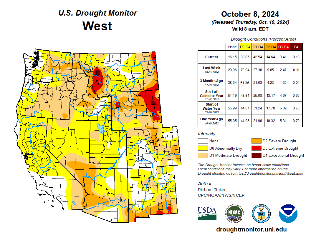
West Drought Monitor map October 8, 2024.
However, the current drought that has lingered for decades now poses a significant threat to everything that depends on the mighty Colorado River. The river basin lies in the region which is infamous for its natural variability. Over the course of history, the region has had cycles of dry and wet periods, which may also make the present drought look like a natural phenomenon alone. However, a study conducted in 2021 showed that around 19% of the current drought conditions can be attributed to human-induced climate change. Not only that, but the conditions are worse than they have been in at least 1200 years.
Since 90% of the streamflow in the Colorado River originates in the upper part of the basin,several studies over the years have focused on watershed modeling in that region many studies have investigated historical flows, while others have included baseflow – the steady release of groundwater that seeps into a stream or river. Some have gone further to use historical streamflow and baseflow to predict future conditions in the river basin using various climate models. However, almost all studies have either used pre-development scenarios – conditions when there was little to no water infrastructure such as dams, canals, levees, etc., management, and regulations – or have used oversimplified models that ignore the complexities of groundwater movement, storage, and interactions with the surface water.
The Colorado River Basin is one of the most highly regulated and over-allocated river systems in the world. As a result, basing studies on pre-development scenarios seems to be of little practical importance in this day of rapidly changing climate. Moreover, the importance of groundwater and its interactions with surface water cannot be ignored, as more than half of the streamflow in the basin is contributed by baseflow.
Colorado transmountain diversions via the State Engineer’s office
The river basin also has trans-basin or trans-mountain diversions. These diversions bring water from the western slope of the Rocky Mountains, which are in the Colorado River Basin, to the eastern slope of the Rockies outside of the basin. These diversions have also been ignored in previous models.
Map credit: AGU
Therefore, my team, which includes my Ph.D. advisor at CSU, Associate Professor Ryan Bailey, and two scientists from the Agricultural Research Service, is working to address this knowledge gap by incorporating key hydrological processes that were overlooked in previous research studies. We are using a physically based and spatially distributed model to build and quantify historical streamflows and groundwater levels in the Upper Colorado River Basin for the post-development scenario. A physically based model simulates how water moves through the environment, using real-world processes, instead of relying on statistical patterns. A spatially distributed model, on the other hand, takes into account differences in the landscape and natural features across different areas. In our model, we have included reservoirs, canals, irrigation schedules, floodplains, trans-basin diversions, and tile drainage – an agricultural drainage system that removes excess subsurface water from irrigated fields. The model also simulates groundwater fluxes such as groundwater recharge, canal seepage, tile drainage flow, saturation excess flow, lake and reservoir seepage and evaporation, and groundwater-floodplain exchanges, which can be used to identify spatio-temporal patterns in the river basin.
Once we simulate the historical hydrology and fluxes, we plan to run what-if scenarios, hypothetical situations to help us analyze different options, for several water management, land use change, and climate change scenarios. This will allow us to come up with best management practices to address water issues and manage water resources more effectively and efficiently.
Historic photo of the Lee’s Ferry gage on the Colorado River. Photo credit: USGS
In the final phase of the study, we use what-if scenarios to assess the political and socio-economic aspects of the model. This includes, crop budgets, agricultural productivity in monetary terms, possibility and probability of Denver getting shut out from trans-mountain diversions in case of a drought, economic implications of sustainable groundwater use, the amount of water flowing at Lee’s Ferry in Arizona – the dividing point of the upper and lower basins, and so on.
The findings of this study can influence how water managers, government agencies, farmers, and other stakeholders approach water use and management for higher revenues and sustainability. Ecologists can gain insights into future streamflows and their potential impacts on aquatic ecosystems. Additionally, it will provide the scientific community with a solid foundation and valuable catalyst for future research. In the long run, these findings can help shape water policy, advancing the goal of achieving integrated regional water management.
M. Raffae
The fate of the Colorado River Basin does not only depend on the climate and its variability, but also on the policies we create that define how we store, move, use, and manage our water. To come up with policies that help us sustain the economy, environment, and society, it is imperative that we conduct a comprehensive hydrological modeling study for the post-development scenario that shows us both our best- and worst-case scenarios for the future to better prepare for it. This study is an ambitious attempt to do so.
About the author: M. Raffae is a Ph.D. student in the Department of Civil and Environmental Engineering at Colorado State University (CSU) funded by the Fulbright Foreign Student scholarship program. He is also a fellow in the NSF Research Traineeship (NRT) Program InTERFEWS at CSU.
Black Canyon July 2020. Photo credit: Cari Bischoff
From email from Reclamation (Erik Knight):
Releases from the Aspinall Unit will be decreased from 1650 cfs to 1550 cfs on Tuesday, August 20th. Releases are being decreased as flows on the lower Gunnison River are well above the baseflow target of 1050 cfs. Further reductions in the release at Crystal may occur soon if river levels remain well above the target.
Flows in the lower Gunnison River are currently above the baseflow target of 1050 cfs. River flows are expected to remain above the baseflow target for the foreseeable future.
Pursuant to the Aspinall Unit Operations Record of Decision (ROD), the baseflow target in the lower Gunnison River, as measured at the Whitewater gage, is 1050 cfs for August through December.
Currently, Gunnison Tunnel diversions are 1050 cfs and flows in the Gunnison River through the Black Canyon are around 600 cfs. After this release change Gunnison Tunnel diversions will still be 1050 cfs and flows in the Gunnison River through the Black Canyon will be around 500 cfs. Current flow information is obtained from provisional data that may undergo revision subsequent to review.
This scheduled release change is subject to changes in river flows and weather conditions. For questions or concerns regarding these operations contact:
Four recently announced federal Bipartisan Infrastructure Law grants for water projects in the region all included one notable common denominator — they all got help in their application process through a special Colorado River District program made possible by a voter-approved tax measure in 2020…According to a news release from the Colorado River District, based in Glenwood Springs, four of the projects are in the district’s boundaries, and all four made use of the district’s Accelerator Grant program, which was established last year to help West Slope water users in navigating the time-consuming and often-expensive requirements for applying for the considerable funding available under the Bipartisan Infrastructure Law. The assistance includes helping pay for feasibility analysis, design, preliminary environmental review and engineering costs. Altogether, through the Bipartisan Infrastructure Law, the Bureau of Reclamation is investing a total of $8.3 billion over five years for water infrastructure projects…
Photo courtesy Wright Water Engineers via the Middle Colorado Watershed Council
■ $746,423 to the Middle Colorado Watershed Council, which in partnership with Garfield County plans to install a fish barrier to prevent non-native fish migration, and upgrade a diversion structure, on Roan Creek outside De Beque.
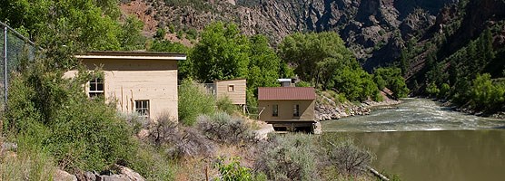
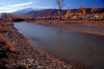
Uncompahgre River Valley looking south
■ Nearly $1.2 million to American Rivers, which, working with partners, plans to upgrade irrigation infrastructure and enhance aquatic and riparian habitats along a mile of the Uncompahgre River;
August, in the Elk Creek valley. Photo: Brent Gardner-Smith/Aspen Journalism
■ About $3 million to Trout Unlimited and the Middle Colorado River Agriculture Collaborative to upgrade, relocate or combine six diversion structures in order to remove instream barriers to fish passage along five miles of Elk Creek in the New Castle area.
Photo credit: Jonathan Thompson
■ Nearly $1.6 million to the Western Slope Conservation Center, which, in partnership with the North Fork Farmer’s Ditch Association, will modernize the Farmers Ditch diversion and headgate structures downstream of Paonia Reservoir to improve upstream fish passage, increase diversion efficiency and improve safety for boaters.
RiversEdge West, a Grand Junction-based nonprofit, received $22,035 from the Colorado River District’s Community Funding Partnership and $34,433 from the Colorado Water Conservation Board to restore two river sites owned by the city of Montrose.
According to RiversEdge West Restoration Coordinator Montana Cohn, the two sites together total around 70 acres, and the project will allow the group to remove about 8 acres worth of invasive tamarisk and Russian olive plants and replace them with native species…One site is off Mayfly Drive, and the other is near Home Depot off Ogden Road. Cohn said restoration efforts at these sites have yielded positive results before, and the new project will expand on previous work. He explained invasive thorns and plants like Russian olive and tamarisk crowd out native vegetation, degrade soil quality and, since some are thorny, block access to the river for wildlife, livestock and recreationists…
The project will go down in phases, starting with volunteer efforts this summer. Then in the fall, paid crews from the Americorps program Western Colorado Conservation Corps will come in with herbicides and chainsaws and remove as many of the invasive plants as possible. Efforts, including volunteer replanting efforts of native plants, will continue into 2024.
The Grand River Diversion Dam, also known as the “Roller Dam”, was built in 1913 to divert water from the Colorado River to the Government Highline Canal, which farmers use to irrigate their lands in the Grand Valley. GVWUA is not participating the rebooted System Conservation Program after water managers couldn’t agree on how much farmers should be paid to cut back their water use. Photo credit: Bethany Blitz/Aspen Journalism
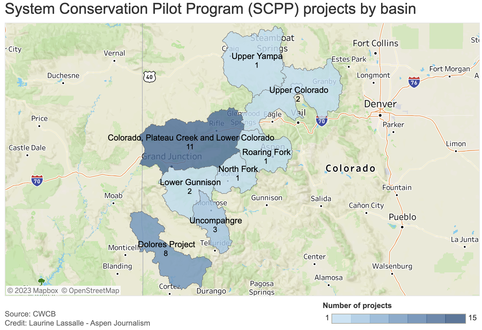
Three of western Colorado’s biggest irrigation districts are not participating on a large scale in a federally funded program to conserve water, and the amount of water saved by the program overall won’t be enough to rescue depleted reservoirs.
The rebooted System Conservation Program was one of the legs of the Upper Colorado River Commission’s 5-Point Plan, announced in July and aimed at protecting critical elevations in Lake Powell and Lake Mead, which have fallen to record-low levels in recent years because of overuse, drought and climate change. System conservation will take place in the four upper Colorado River basin states — Colorado, New Mexico, Wyoming and Utah — and will pay water users to cut back. It’s being funded by $125 million from the federal Inflation Reduction Act.
The total water estimated to be saved across the upper basin for this year of the restarted, temporary and voluntary System Conservation Program is nearly 39,000 acre-feet. By comparison, Lake Powell when full holds more than 23 million acre-feet; Ruedi Reservoir, on the Fryingpan River, can hold about 100,000 acre-feet. (An acre-foot is the amount of water needed to cover an acre of land to a depth of 1 foot and can supply one to two households a year.)
Becky Mitchell, Colorado commissioner to the UCRC, said in a UCRC meeting last month that although the upper basin will do its part in response to last summer’s calls from the federal government that the seven Colorado River basin states needed to conserve 2 million to 4 million acre-feet of water, the majority of that needs to come from cuts in the lower basin (California, Arizona and Nevada).
“(System conservation) will not resolve the crisis in the reservoirs,” she said.
Last month the UCRC approved moving forward with executing agreements with program participants, which are still being finalized.
Although a goal of the program was to get participation across all water sectors — agricultural, municipal and industrial — all of the projects proposed in Colorado involve Western Slope agriculture. None of the state’s Front Range water providers, which collectively take about 500,000 acre-feet per year of the Colorado River’s headwaters across the Continental Divide to thirsty cities and farms, are participating.
Paying water users to irrigate less has long been controversial on the Western Slope, with fears that these temporary and voluntary programs could lead to a permanent “buy and dry” situation that would negatively impact rural farming and ranching communities.
Of the four upper basin states, Colorado has the largest number of projects (29) but the least amount of saved water (3,532 acre-feet). This is an indication that most of Colorado’s participants are proposing small projects. UCRC Executive Director Chuck Cullom said if the program is undertaken again, officials may consider a minimum size requirement because doing very small projects may not be worth it.
“From a practical standpoint of the cost of monitoring and administering a verification program for that (small number of) acres may not pencil out relative to the amount of water conserved,” Cullom said.
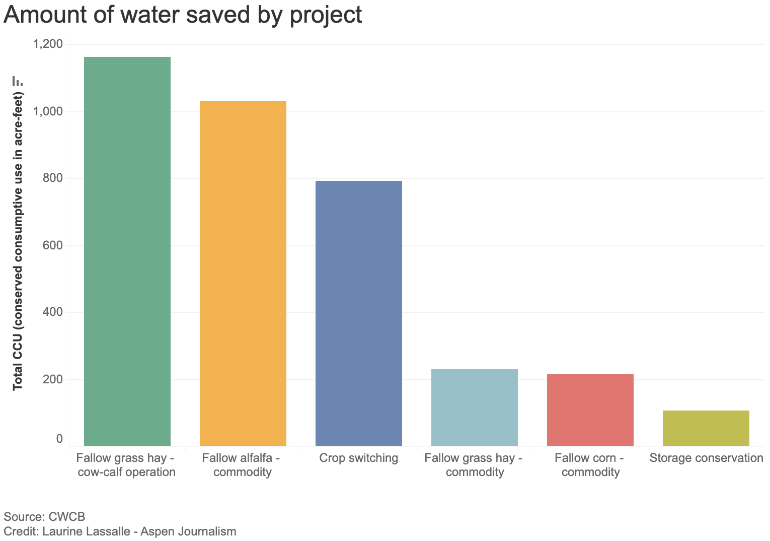
Of the 29 Colorado projects, most involve reducing water use for forage crops, according to information provided by UCRC. Eight involve fallowing grass hay as part of a cow-calf operation, saving 1,163 acre-feet of water; seven plan to fallow alfalfa and save 1,029 acre-feet; and eight propose switching to less-thirsty crops, saving 791 acre-feet.
The UCRC received 88 proposals across the four states, 72 of which met the qualifying criteria. Utah has 20 projects that meet preliminary criteria; Wyoming has 22 and New Mexico has one. The UCRC’s opening offer was $150 per acre-foot of saved water, but the average compensation will probably end up being higher — $434 per acre-foot, according to information provided by UCRC.
Grand Valley Water Users Association not participating
Although some water users in the Grand Valley Water Users Association participated in the original system conservation pilot program, which ran from 2015 to 2018 and conserved 47,000 acre-feet of water at a cost of about $8.6 million, they won’t be taking part this time around.
The Government Highline Canal flows past Highline State Park in the Grand Valley. CREDIT: BETHANY BLITZ/ASPEN JOURNALISM
GVWUA, whose Highline Canal delivers water to roughly 24,000 acres of farmland on the north side of the valley between Grand Junction and Mack, withdrew its application from the process after manager Tina Bergonzini said she couldn’t come to an agreement on the price with the UCRC. GVWUA had rejected the concept of paying farmers based on an amount of unused water, instead proposing to pay farmers for each acre of land they took out of production.
Individual farmers would have had to apply to the program through the association, which proposed to cap total member participation at 1,000 acres and 3,000 acre-feet of water.
GVWUA was asking for between $686 and $1,306 per each acre fallowed, depending on whether farmers reduced water use during the entire irrigation season or just part of it.
Bergonzini said the price represents what it would cost to administer the program in a way that provides equity and protection; at any lower price, the funding from system conservation would not be enough to cover the extra staff and engineering costs. Cullom said his organization was unlikely to approve those costs, so GVWUA withdrew its application.
“They were not wanting to pay per acre what we had requested,” Bergonzini said. “They had a line drawn in the sand and so did I.”
The Grand Valley Irrigation Company, which serves about 40,000 acres of farmland between Palisade and Mack, has four projects proposed within its service area, covering a total of 120 acres and 285 acre-feet of water savings.
“It’s not a very big amount,” said GVIC Assistant Superintendent Charlie Guenther. “I did hear from a handful of ag people that they didn’t want to be part of this because it sounded very technical and it was government involvement. That’s something that came up.”
Unlike GVWUA, individual water users within GVIC did not have to apply to the program through the irrigation company, and the company’s board did not take a stance on whether or not to support system conservation, according to Guenther.
There is just one conservation project proposed in the boundaries of the Uncompahgre Valley Water Users Association, the largest irrigation district in Western Colorado, at more than 83,000 acres of farmland in Delta and Montrose counties. The project would enroll about 33 acres in the program and would result in about 46 acre-feet of water savings.
UVWUA manager Steve Pope said the system conservation program didn’t get much interest from his water users because of the timing. Bergonzini agreed.
“They didn’t want to do a last-minute thing,” Pope said. “By the time this thing was rolled out, these guys had already made their decisions and they were already committed for the next season.”
Cullom has acknowledged that there were shortcomings with the program’s rollout. The UCRC unveiled details of the program in December, with an original application deadline of Feb. 1, which was later pushed to March 1 for this summer’s irrigation season.
“We need to do much better when we think about how to do this in the future, if we do this in the future,” he said. “We need more clarity on the data requirements, what we expect from a proposal. We need to give people more time to engage in understanding what the opportunity is and we need to start sooner. Start in the fall for an irrigation season instead of January.”
Conservation district concerns
The Western Slope’s two largest conservation districts — the Colorado River Water Conservation District and Southwestern Water Conservation District — submitted letters to the UCRC stating their concerns with the program. Mitchell had promised the districts that they could participate in the review and approval process for applications, thereby securing a measure of local control. But in March, she walked back that commitment, saying the UCRC had sole authority in the approval process.
The UCRC has released few details so far on project proposal specifics, and publicly available applications have been heavily redacted. In addition to redacting the applicants’ personal identifying information, nearly everything else has been blacked out: the precise location of projects; which streams and ditches are involved; details of the water rights involved; and how much the applicants are asking to be paid for their water.
The districts say this makes it impossible to meaningfully review them to determine whether the projects would cause injury to other water users. Their letters to the UCRC say the lack of transparency raises questions about whether public funds are being used wisely.
“In short, SWCD is very disappointed and concerned about the process that has been undertaken by the UCRC and the state of Colorado,” reads the letter from Southwestern General manager Steve Wolff.
In response, Amy Ostdiek, CWCB section chief for interstate, federal and water information, said that the review process respected project proponents’ privacy and that striking a balance between transparency and privacy is an ongoing effort.
“The Colorado State Engineer’s Office has been directly involved as implementation agreements and verification plans are developed to ensure no injury results from SCPP participation,” Ostdiek said in an email.
She said additional information will be available when the UCRC finalizes agreements with project participants, which should happen late this month, according to Cullom.
The 39,000 acre-feet of water across the four upper-basin states will do little to boost Lake Powell. It’s the proverbial drop in the bucket. But the political value of 39,000 acre-feet may be far greater than any benefit to the nation’s second-largest reservoir. The effort shows that upper-basin water managers are willing to do their part to prevent the system from crashing, but that part is small compared with the cuts they say are needed in the lower basin.
“It’s unlikely any system conservation stood up in the upper basin is going to move the needle,” Cullom said. “But it’s important for the upper basin to participate and contribute within the resources and the tools we have available, and what we are demonstrating in this process is that we do have tools, we do have resources. They are narrow in scope and small in volume.”
Saying the state will fare best if it stands together when it comes to protecting Colorado River water rights, Western Slope legislators are hailing a bill that creates a drought task force.
“It’s to get Colorado to come to the table and start talking about what we can do, rather than somebody on the eastern side of the state, or the governor, talking,” Rep. Marc Catlin, R-Montrose, who was House sponsor of Senate Bill 295, with Rep. Julie McCluskie, D-Dillon, House speaker. “We’re trying to get people from the Western Slope, particularly since the Western Slope is going to have to deal with it.”
Senate Bill 295 passed 63-2, with Sens. Perry Will, R-Newcastle, and Dylan Robert, D-Eagle, carrying it in the Senate. The bill creates a Colorado River Drought Task Force, with subcommittees, to guide the development of water legislation. It is to include the Ute Mountain Ute and Southern Ute tribes, regional water conservation districts, local government, farmers, ranchers, environmental nonprofits and the Colorado Department of Natural Resources. Members are charged with developing steps and tools the legislature can use to address drought in the Colorado River Basin and commitments under the Colorado River Compact through conservation of the river and its tributaries, such as the Gunnison River and the Uncompahgre. If the bill creating the task force is signed into law, its members have a short window to act: between July and Dec. 15, they are to furnish their recommendations and a summary of their work to the legislative water resources and agricultural review committee…
The bill says recommendations need to be for programs that can be reasonably implemented in a way that does not harm economic or environmental concerns in any sub-basin or region in the state. The recommendations must also fall in line with the 2019 Colorado River Drought Contingency Plan. The recommendations must further ensure any program related to acquiring water rights is voluntary, temporary and compensated, while also looking at revenue sources for the acquisition of program water. [Perry] Will and [Marc] Catlin worry about entities that are purchasing farm land, as well as buying or leasing water, especially if they are not providing adequate compensation…
“The Uncompahgre (River), we’ve got the oldest, biggest water right on the Western Slope of Colorado. Certainly, there are people looking at us,” Catlin said. He said speculators need to understand that when they buy water, they are affecting the entire ag community, not just individual farmers — and that reality needs to be part of the conversation.
WAM bought this 57-acre parcel as part of a $6 million deal in January 2020, leading some to suspect the company was engaging in investment water speculation. WAM’s activity in the Grand Valley helped prompt state legislators to propose a bill aimed at curbing speculation.
CREDIT: BETHANY BLITZ/ASPEN JOURNALISM
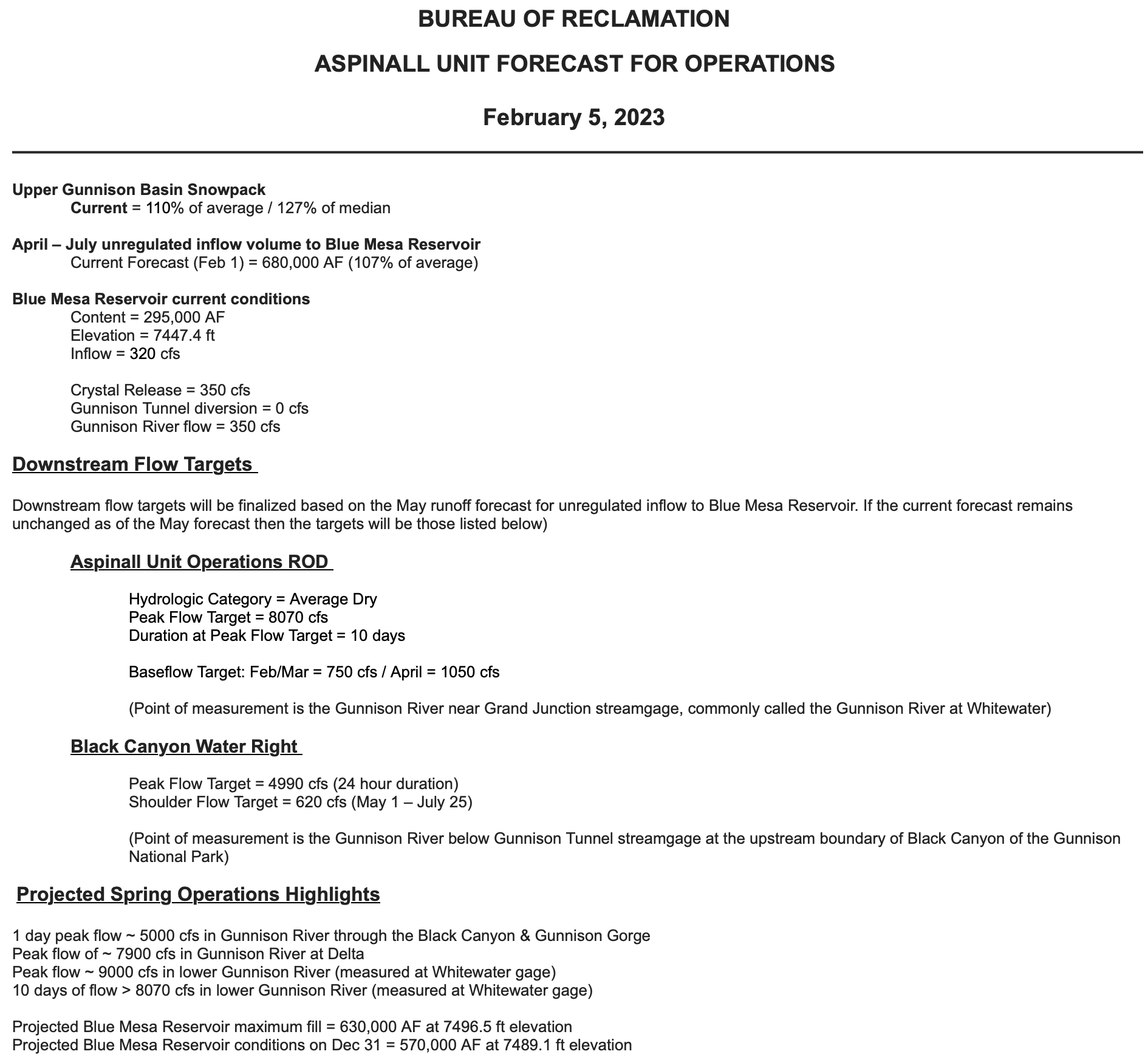
The May 1st forecast for the April – July unregulated inflow volume to Blue Mesa Reservoir is 830,000 acre-feet. This is 131% of the 30 year average. Snowpack in the Upper Gunnison Basin peaked at 138% of average. Blue Mesa Reservoir current content is 434,000 acre-feet which is 52% of full. Current elevation is 7470.4 ft. Maximum content at Blue Mesa Reservoir is 828,00 acre-feet at an elevation of 7519.4 ft.
Based on the May forecasts, the Black Canyon Water Right and Aspinall Unit ROD peak flow targets are listed below:
Black Canyon Water Right
The peak flow target is equal to 6,400 cfs for a duration of 24 hours.
The shoulder flow target is 810 cfs, for the period between May 1 and July 25.
Aspinall Unit Operations ROD
The year type is currently classified as Average Wet.
The peak flow target is currently 14,300 cfs and the duration target at this flow is currently 2 days.
The half bankfull target is currently 8,070 cfs and the duration target at this flow is currently 20 days.
Pursuant to the Aspinall Unit Operations ROD, releases from the Aspinall Unit will be made in an attempt to match the peak flow of the North Fork of the Gunnison River to maximize the potential of meeting the desired peak at the Whitewater gage, while simultaneously meeting the Black Canyon Water Right peak flow amount. The latest forecast for flows on the North Fork of the Gunnison River shows a high peak flow occurring near the middle of next week. Flows in the tributaries downstream of the North Fork confluence are also very high, which will help with meeting the flow targets on the lower Gunnison River at the Whitewater gage.
Therefore ramp up for the spring peak operation will begin on Friday, May 12th, with the intent of timing releases with this potential higher flow period on the North Fork of the Gunnison River. Releases from Crystal Dam will be ramped up according to the guidelines specified in the EIS, with 2 release changes per day, until Crystal begins to spill. The release schedule for Crystal Dam is:
Crystal Dam will be at full powerplant and bypass release on May 15th. Crystal Reservoir will begin spilling by May 16th and the peak release from Crystal Dam should be reached on May 18th. The flows in the Gunnison River after that date will be dependent on the timing of the spill and the level of tributary flow contribution. Estimates of those numbers will be determined in the upcoming days.
The current projection for spring peak operations shows flows in the Gunnison River through the Black Canyon peaking at 6400 cfs in order to achieve the desired peak flow and duration at Whitewater. Actual flows will be dependent on the downstream contribution of the North Fork of the Gunnison River and other tributaries. Higher tributary flows will lead to lower releases from the Aspinall Unit and vice versa.
Click the link to read the article on the Montrose Daily Press website (Katharhynn Heidelberg). Here’s an excerpt:
When Luz Marquez returned to her Heritage Estates home off Marine Road Wednesday morning, she was prepared for an ordinary day. What she found was water — lots of it, pooling in her backyard, flowing under a raised shed, and carving small trenches through her parking area to dump the gravel there into the street…
Montrose County had been anticipating flooding this year, based on high snowpack and the potential for a quick melt and runoff. The county was getting sand and sandbags ready for distribution, cleaning ditches and had a contractor lined up for the work. But the water came even sooner than expected.
“It came a little quicker than we thought,” Montrose County Road and Bridge Superintendent Brandon Wallace said, as he and other county staff worked at Heritage Estates. “We watched all night and it decided it really wanted to release. We were trying to get a game plan to clear out some of these drainage ditches cleaned out to alleviate some of this water.”
Montrose County was on alert for weeks, in light of intense snowpack, which just weeks ago stood at record highs in parts of the Gunnison River Basin…The water came roaring about a week sooner than was expected, upending the county’s plans to clear out drainage ditches when things are a bit drier. “The water just beat us to it. We really thought we had a little bit bigger window to get it cleaned when it was dry,” Hawkins said.
A way-above-average snowpack has already begun melting, meaning rivers on the Western Slope will likely be rushing this year — and some nearby adventure outfitters will be happy to see it. The increased flows will likely have both positive and negative impacts on the services, but owners and managers agreed: southwestern Colorado needs water, and nobody’s complaining about it…
As of March 21, the Daily Press reported SnoTel sites above nearby waterways and their reservoirs show big-time snowpack, with the gauge at Columbine Pass sitting at 262% of normal and more than 41 inches of snow water equivalent on the Uncompahgre Plateau. It’s already melting, as evidenced by the flooding seen earlier this week at the Heritage Estates neighborhood off Marine Road.
Known for its breathtaking scenery, the Dominguez-Escalante National Conservation Area is a fine example of the spectacular canyon country of Colorado’s Uncompahgre Plateau. Red-rock canyons and sandstone bluffs hold geological and paleontological resources spanning 600 million years, as well as many cultural and historic sites. The Ute Tribes today consider these pinyon-juniper–covered lands an important connection to their ancestral past. The Escalante, Cottonwood, Little Dominguez and Big Dominguez Creeks cascade through sandstone canyon walls that drain the eastern Uncompahgre Plateau. Unaweep Canyon on the northern boundary of the NCA contains globally significant geological resources. Nearly 30 miles (48 km) of the Gunnison River flow through the Dominguez-Escalante NCA, supporting fish, wildlife and recreational resources. The Old Spanish National Historic Trail, a 19th Century land trade route, also passes through it. A variety of wildlife call the area home, including desert bighorn sheep, mule deer, golden eagle, turkey, elk, mountain lion, black bear, and the collared lizard. There are 115 miles (185 km) of streams and rivers in the NCA, and there is habitat suitable for 52 protected species of animals and plants. By Bob Wick; Bureau of Land Management – Dominguez-Escalante NCA, Public Domain, https://commons.wikimedia.org/w/index.php?curid=42092807
by Abrahm Lustgarten
ProPublica is a Pulitzer Prize-winning investigative newsroom. Sign up for The Big Story newsletter to receive stories like this one in your inbox.
On a crisp day this fall I drove southeast from Grand Junction, Colorado, into the Uncompahgre Valley, a rich basin of row crops and hayfields. A snow line hung like a bowl cut around the upper cliffs of the Grand Mesa, while in the valley some farmers were taking their last deliveries of water, sowing winter wheat and onions. I turned south at the farm town of Delta onto Route 348, a shoulder-less two-lane road lined with irrigation ditches and dent corn still hanging crisp on their browned stalks. The road crossed the Uncompahgre River, and it was thin, nearly dry.
The Uncompahgre Valley, stretching 34 miles from Delta through the town of Montrose, is, and always has been, an arid place. Most of the water comes from the Gunnison River, a major tributary of the Colorado, which courses out of the peaks of the Elk Range through the cavernous and sun-starved depths of the Black Canyon, one rocky and inaccessible valley to the east. In 1903, the federal government backed a plan hatched by Uncompahgre farmers to breach the ridge with an enormous tunnel and then in the 1960s to build one of Colorado’s largest reservoirs above the Black Canyon called Blue Mesa. Now that tunnel feeds a neural system of water: 782 miles worth of successively smaller canals and then dirt ditches, laterals and drains that turn 83,000 Western Colorado acres into farmland. Today, the farm association in this valley is one of the largest single users of Colorado River water outside of California.
I came to this place because the Colorado River system is in a state of collapse. It is a collapse hastened by climate change but also a crisis of management. In 1922, the seven states in the river basin signed a compact splitting the Colorado equally between its upper and lower halves; later, they promised additional water to Mexico, too. Near the middle, they put Lake Powell, a reserve for the northern states, and Lake Mead, a storage node for the south. Over time, as an overheating environment has collided with overuse, the lower half — primarily Arizona and California — has taken its water as if everything were normal, straining both the logic and the legal interpretations of the compact. They have also drawn extra releases from Lake Powell, effectively borrowing straight out of whatever meager reserves the Upper Basin has managed to save there.
This much has become a matter of great, vitriolic dispute. What is undeniable is that the river flows as a much-diminished version of its historical might. When the original compact gave each half the rights to 7.5 million acre-feet of water, the river is estimated to have flowed with as much as 18 million acre-feet each year. Over the 20th century, it averaged closer to 15. Over the past two decades, the flow has dropped to a little more than 12. In recent years, it has trickled at times with as little as 8.5. All the while the Lower Basin deliveries have remained roughly the same. And those reservoirs? They are fast becoming obsolete. Now the states must finally face the consequential question of which regions will make their sacrifice first. There are few places that reveal how difficult it will be to arrive at an answer than the Western Slope of Colorado.
In Montrose, I found the manager of the Uncompahgre Valley Water Users Association, Steve Pope, in his office atop the squeaky stairs of the same Foursquare that the group had built at the turn of the last century. Pope, bald, with a trimmed white beard, sat amid stacks of plat maps and paper diagrams of the canals, surrounded by LCD screens with spreadsheets marking volumes of water and their destinations. On the wall, a historic map showed the farms, wedged between the Uncompahgre River and where it joins the Gunnison in Delta, before descending to their confluence with the Colorado in Grand Junction. “I’m sorry for the mess,” he said, plowing loose papers aside.
Colorado Rivers. Credit: Geology.com
What Pope wanted to impress upon me most despite the enormousness of the infrastructure all around the valley was that in the Upper Basin of the Colorado River system, there are no mammoth dams that can simply be opened to meter out a steady release of water. Here, only natural precipitation and temperature dictate how much is available. Conservation isn’t a management decision, he said. It was forced upon them by the hydrological conditions of the moment. The average amount of water flowing in the system has dropped by nearly 20%. The snowpack melts and evaporates faster than it used to, and the rainfall is unpredictable. In fact, the Colorado River District, an influential water conservancy for the western part of the state, had described its negotiating position with the Lower Basin states by claiming Colorado has already conserved about 28% of its water by making do with the recent conditions brought by drought.
You get what you get, Pope tells me, and for 15 of the past 20 years, unlike the farmers in California and Arizona, the people in this valley have gotten less than what they are due. “We don’t have that luxury of just making a phone call and having water show up,” he said, not veiling his contempt for the Lower Basin states’ reliance on lakes Mead and Powell. “We’ve not been insulated from this climate change by having a big reservoir above our heads.”
He didn’t have to point further back than the previous winter. In 2021, the rain and snow fell heavily across the Rocky Mountains and the plateau of the Grand Mesa, almost as if it were normal times. Precipitation was 80% of average — not bad in the midst of an epochal drought. But little made it into the Colorado River. Instead, soils parched by the lack of rain and rising temperatures soaked up every ounce of moisture. By the time water reached the rivers around Montrose and then the gauges above Lake Powell, the flow was less than 30% of normal. The Upper Basin states used just 3.5 million acre-feet last year, less than half their legal right under the 1922 compact. The Lower Basin states took nearly their full amount, 7 million acre-feet.
Colorado River Basin Plumbing. Credit: Lester Doré/Mary Moran via Dustin Mulvaney and Twitter
All of this matters now not just because the river, an unwieldy network of human-controlled plumbing, is approaching a threshold where it could become inoperable, but because much of the recent legal basis for the system is about to dissolve. In 2026, the Interim Guidelines the states rely on, a Drought Contingency Plan and agreements with Mexico will all expire. At the very least, this will require new agreements. It also demands a new way of thinking that matches the reality of the heating climate and the scale of human need. But before that can happen, the states will need to restore something that has become even more scarce than the water: trust.
The northern states see California and Arizona reveling in profligate use, made possible by the anachronistic rules of the compact that effectively promise them water when others have none. It’s enabled by the mechanistic controls at the Hoover Dam, which releases the same steady flow no matter how little snow falls across the Rocky Mountains. California flood-irrigates alfalfa crops destined for cattle markets in the Middle East, while Arizona takes water it does not need and pumps it underground to build up its own reserves. In 2018, an Arizona water agency admitted it was gaming the timing of its orders to avoid rations from the river (though it characterized the moves as smart use of the rules). In 2021, in a sign of the growing wariness, at least one Colorado water official alleged California was repeating the scheme. California water officials say this is a misunderstanding. Yet to this day, because California holds the most senior legal rights on the river, the state has avoided having a single gallon of reductions imposed on it.
Updated Colorado River 4-Panel plot thru Water Year 2022 showing reservoirs, flows, temperatures and precipitation. All trends are in the wrong direction. Since original 2017 plot, conditions have deteriorated significantly. Brad Udall via Twitter: https://twitter.com/bradudall/status/1593316262041436160
By this spring, Lake Powell shrank to 24% of its capacity, its lowest levels since the reservoir filled in the 1960s. Cathedral-like sandstone canyons were resurrected, and sunlight reached the silt-clogged floors for the first time in generations. The Glen Canyon Dam itself towered more than 150 feet above the waterline. The water was just a few dozen feet above the last intake pipe that feeds the hydropower generators. If it dropped much lower, the system would no longer be able to produce the power it distributes across six states. After that, it would approach the point where no water at all could flow into the Grand Canyon and further downstream. All the savings that the Upper Basin states had banked there were as good as gone.
In Western Colorado, meanwhile, people have been suffering. South of the Uncompahgre Valley, the Ute Mountain Ute tribe subsists off agriculture, but over the past 12 months it has seen its water deliveries cut by 90%; the tribe laid off half of its farmworkers. McPhee Reservoir, near the town of Cortez, has teetered on failure, and other communities in Southwestern Colorado that also depend on it have been rationed to 10% of their normal water.
Across the Upper Basin, the small reservoirs that provide the region’s only buffer against bad years are also emptying out. Flaming Gorge, on the Wyoming-Utah border, is the largest, and it is 68% full. The second largest, Navajo Reservoir in New Mexico, is at 50% of its capacity. Blue Mesa Reservoir, on the Gunnison, is just 34% full. Each represents savings accounts that have been slowly pilfered to supplement Lake Powell as it declines, preserving the federal government’s ability to generate power there and obscuring the scope of the losses. Last summer, facing the latest emergency at the Glen Canyon Dam, the Department of Interior ordered huge releases from Flaming Gorge, Blue Mesa and other Upper Basin reservoirs. At Blue Mesa, the water levels dropped 8 feet in a matter of days, and boaters there were given a little more than a week to get their equipment off the water. Soon after, the reservoir’s marinas, which are vital to that part of Colorado’s summer economy, closed. They did not reopen in 2022.
South Canal. Photo credit: Delta-Montrose Electric Association via The Mountain Town News
As the Blue Mesa Reservoir was being emptied last fall, Steve Pope kept the Gunnison Tunnel open at its full capacity, diverting as much water as he possibly could. He says this was legal, well within his water rights and normal practice, and the state’s chief engineer agrees. Pope’s water is accounted for out of another reservoir higher in the system. But in the twin takings, it’s hard not to see the bare-knuckled competition between urgent needs. Over the past few years, as water has become scarcer and conservation more important, Uncompahgre Valley water diversions from the Gunnison River have remained steady and at times even increased. The growing season has gotten longer and the alternative sources, including the Uncompahgre River, less reliable. And Pope leans more than ever on the Gunnison to maintain his 3,500 shareholders’ supply. “Oh, we are taking it,” he told me, “and there’s still just not enough.”
On June 14, Camille Touton, the commissioner of the U.S. Bureau of Reclamation, the Department of Interior division that runs Western water infrastructure, testified before the Senate Committee on Energy and Natural Resources and delivered a stunning ultimatum: Western states had 60 days to figure out how to conserve as much as 4 million acre-feet of “additional” water from the Colorado River or the federal government would, acting unilaterally, do it for them. The West’s system of water rights, which guarantees the greatest amount of water to the settlers who arrived in the West and claimed it first, has been a sacrosanct pillar of law and states’ rights both — and so her statement came as a shock.
Would the department impose restrictions “without regard to river priority?” Mark Kelly,, the Democratic senator from Arizona, asked her.
“Yes,” Touton responded.
For Colorado, this was tantamount to a declaration of war. “The feds have no ability to restrict our state decree and privately owned ditches,” the general manager of the Colorado River District, Andy Mueller, told me. “They can’t go after that.” Mueller watches over much of the state.Pope faces different stakes. His system depends on the tunnel, a federal project, and his water rights are technically leased from the Bureau of Reclamation, too. Touton’s threat raised the possibility that she could shut the Uncompahgre Valley’s water off. Even if it was legal, the demands seemed fundamentally unfair to Pope. “The first steps need to come in the Lower Basin,” he insisted.
Each state retreated to its corners, where they remain. The 60-day deadline came and went, with no commitments toward any specific reductions in water use and no consequences. The Bureau of Reclamation has since set a new deadline: Jan. 31. Touton, who has publicly said little since her testimony to Congress, declined to be interviewed for this story. In October, California finally offered a plan to surrender roughly 9% of the water it used, albeit with expensive conditions. Some Colorado officials dismissed the gesture as a non-starter. Ever since, Colorado has become more defiant, enacting policies that seem aimed at defending the water the state already has — perhaps even its right to use more.
For one, Colorado has long had to contend with the inefficiencies that come with a “use it or lose it” culture. State water law threatens to confiscate water rights that don’t get utilized, so landowners have long maximized the water they put on their fields just to prove up their long-term standing in the system. This same reflexive instinct is now evident among policymakers and water managers across the state, as they seek to establish the baseline for where negotiated cuts might begin. Would cuts be imposed by the federal government based on Pope’s full allocation of water or on the lesser amount with which he’s been forced to make do? Would the proportion be adjusted down in a year with no snow? “We don’t have a starting point,” he told me. And so the higher the use now, the more affordable the conservation later.
Colorado and other Upper Basin states have also long hid behind the complexity of accurately accounting for their water among infinite tributaries and interconnected soils. [ed. emphasis mine] The state’s ranchers like to say their water is recycled five times over, because water poured over fields in one place invariably seeps underground down to the next. In the Uncompahgre Valley, it can take months for the land at its tail to dry out after ditches that flood the head of the valley are turned off. The measure of what’s been consumed and what has transpired from plants or been absorbed by soils is frustratingly elusive. That, too, leaves the final number open to argument and interpretation.
All the while, the Upper Basin states are all attempting to store more water within their boundaries. Colorado has at least 10 new dams and reservoirs either being built or planned. Across the Upper Basin, an additional 15 projects are being considered, including Utah’s audacious $2.4 billion plan to run a new pipeline from Lake Powell, which would allow it to transport something closer to its full legal right to Colorado River water to its growing southern cities. Some of these projects are aimed at securing existing water and making its timing more predictable. But they are also part of the Upper Colorado River Commission’s vision to expand the Upper Basin states’ Colorado River usage to 5.4 million acre-feet a year by 2060.
It is fair to say few people in the state are trying hard to send more of their water downstream. In our conversation, Mueller would not offer any specific conservation savings Colorado might make. The state’s chief engineer and director of its Division of Water Resources, Kevin Rein, who oversees water rights, made a similar sentiment clear to the Colorado River District board last July. “There’s nothing telling me that I should encourage people to conserve,” Rein said. “It’s a public resource. It’s a property right. It’s part of our economy.”
In November, Democratic Gov. Jared Polis proposed the creation of a new state task force that would help him capture every drop of water it can before it crosses the state line. It would direct money and staff to make Colorado’s water governance more sophisticated, defensive and influential.
I called Polis’ chief water confidante, Rebecca Mitchell, who is also the director of the Colorado Water Conservation Board and the state’s representative on the Upper Colorado River Commission. If the mood was set by the idea that California was taking too much from the river, Mitchell thought that it had shifted now to a more personal grievance — they are taking from us.
On a day in late May [2022] when wildfire smoke obscured the throat of an ancient volcano called Shiprock in the distance, I visited the Ute Mountain Ute farming and ranching operation in the southwestern corner of Colorado. Photo credit: Allen Best/Big Pivots
Last month, Mitchell flew to California for a tour of its large irrigation districts. She stood beside a wide canal brimming with more water than ever flows through the Uncompahgre River, and the executive of the farming company beside her explained that he uses whatever he wants because he holds the highest priority rights to the water. She thought about the Ute Mountain Ute communities and the ranchers of Cortez: “It was like: ‘Wouldn’t we love to be able to count on something? Wouldn’t we love to be feel so entitled that no matter what, we get what we get?’” she told me.
What if Touton followed through, curtailing Colorado’s water? I asked. Mitchell’s voice steadied, and then she essentially leveled a threat. “We would be very responsive. I’m not saying that in a positive way,” she said. “I think everybody that’s about to go through pain wants others to feel pain also.”
Here’s the terrible truth: There is no such thing as a return to normal on the Colorado River, or to anything that resembles the volumes of water its users are accustomed to taking from it. With each degree Celsius of warming to come, modelers estimate that the river’s flow will decrease further, by an additional 9%. At current rates of global warming, the basin is likely to sustain at least an additional 18% drop in its water supplies over the next several decades, if not far more. Pain, as Mitchell puts it, is inevitable.
The thing about 4 million acre-feet of cuts is that it’s merely the amount already gone, an adjustment that should have been made 20 years ago. Colorado’s argument makes sense on paper and perhaps through the lens of fairness. But the motivation behind the decades of delay was to protect against the very argument that is unfolding now — that the reductions should be split equally, and that they may one day be imposed against the Upper Basin’s will. It was to preserve the northern states’ inalienable birthright to growth, the promise made to them 100 years ago. At some point, though, circumstances change, and a century-old promise, unfulfilled, might no longer be worth much at all. Meanwhile, the politics of holding out are colliding with climate change in a terrifying crash, because while the parties fight, the supply continues to dwindle.
Average combined storage assuming drought conditions continue
Average end-of-year combined Lake Powell and Lake Mead storage is shown, assuming hydrologic conditions of the Millennium Drought continue. Results show combined reservoir contents using a range of Upper Basin consumptive use limits (colored ribbons) along with a range of Lower Basin maximum consumptive use reductions (line styles) triggered when the combined storage falls below 15 million acre-feet (MAF). The status quo lines use the 2016 Upper Colorado River Commission (UCRC) projections and existing elevation-based shortage triggers. All water use and shortage values are annual volumes (MAF/year).
Recently, Brad Udall, a leading and longtime analyst of the Colorado River and now a senior water and climate scientist at Colorado State University, teamed with colleagues to game out what they thought it would take to bring the river and the twin reservoirs of Mead and Powell into balance. Their findings, published in July in the journal Science, show that stability could be within reach but will require sacrifice.
If the Upper Basin states limited their claim to 4 million acre-feet, or 53% of their due under the original compact, and the Lower Basin states and Mexico increased their maximum emergency cuts by an additional 45%, the two big reservoirs will stay at roughly their current levels for the next several decades. If the basins could commit to massive reductions below even 2021 levels for the Upper Basin and to more than doubling the most ambitious conservation goals for the south, the reservoirs could once again begin to grow, providing the emergency buffer and the promise of economic stability for 40 million Americans that was originally intended. Still, by 2060, they would only be approximately 45% full.
Any of the scenarios involve cuts that would slice to the bone. Plus, there’s still the enormous challenge of how to incorporate Native tribes, which also hold huge water rights but continue to be largely left out of negotiations. What to do next? Israel provides one compelling example. After decades of fighting over the meager trickles of the Jordan River and the oversubscription of a pipeline from the Sea of Galilee, Israel went back to the drawing board on its irrigated crops. It made drip irrigation standard, built desalination plants to supply water for its industry and cities, and reused that water again and again; today, 86% of the country’s municipal wastewater is recycled, and Israel and its farmers have an adequate supply. That would cost a lot across the scale and reach of a region like the Western United States. But to save the infrastructure and culture that produces 80% of this country’s winter vegetables and is a hub of the nation’s food system for 333 million people? It might be worth it.
A different course was charted by Australia, which recoiled against a devastating millennium drought that ended 13 years ago. It jettisoned its coveted system of water rights, breaking free of history and prior appropriation similar to the system of first-come-first-served the American West relies on. That left it with a large pool of free water and political room to invent a new method of allocating it that better matched the needs in a modern, more populous and more urban Australia and better matched the reality of the environment.
In America, too, prior appropriation, as legally and culturally revered as it is, may have become more cumbersome and obstructive than it needs to be. Western water rights, according to Newsha Ajami, a leading expert at Lawrence Berkeley National Laboratory and the former director of the urban water policy program at Stanford University, were set up by people measuring with sticks and buckets, long before anyone had ever even considered climate change. Today, they largely serve powerful legacy interests and, because they must be used to be maintained, tend to dissuade conservation. “It’s kind of very archaic,” she said. “The water rights system would be the first thing I would just dismantle or revisit in a very different way.”
This is probably not going to happen, Ajami said. “It could be seen as political suicide.” But that doesn’t make it the wrong solution. In fact, what’s best for the Colorado, for the Western United States, for the whole country might be a combination of what Israel and Australia mapped out. Deploy the full extent of the technology that is available to eliminate waste and maximize efficiency. Prioritize which crops and uses are “beneficial” in a way that attaches the true value of the resource to the societal benefit produced from using it. Grow California and Arizona’s crops in the wintertime but not in the summer heat. And rewrite the system of water allocation as equitably as possible so that it ensures the modern population of the West has the resources it needs while the nation’s growers produce what they can.
What would that look like in Colorado? It might turn the system upside down. Lawsuits could fly. The biggest, wealthiest ranches with the oldest water rights stand to lose a lot. The Lower and Upper Basin states, though, could all divide the water in the river proportionately, each taking a percentage of what flowed. The users would, if not benefit, at least equally and predictably share the misery. Pope’s irrigation district and the smallholder farmers who depend on it would likely get something closer to what they need and, combined with new irrigation equipment subsidized by the government, could produce what they want. It wouldn’t be pretty. But something there would survive.
The alternative is worse. The water goes away or gets bought up or both. The land of Western Colorado dries up, and the economies around it shrivel. Montrose, with little left to offer, boards up its windows, consolidates its schools as people move away, and the few who remain have less. Until one day, there is nothing left at all.
‘Colorado River “Beginnings”. Photo: Brent Gardner-Smith/Aspen Journalism
Project 7 Water Authority scored another grant to help it add critical infrastructure. The Colorado River District’s Accelerator Grant program awarded Project 7 $46,600, to be used in developing a competitive federal funding application.
Project 7 provides drinking water for about 60,000 people in the Uncompahgre River Valley and is in the process of developing a backup treatment facility to deliver treated water from Ridgway Reservoir. Currently, Montrose, Delta and Ouray counties’ drinking water comes from a single treatment plant, using water from Blue Mesa Reservoir that is delivered via the Gunnison Tunnel.
The Colorado River District funding will help pay for a feasibility study and a grant application to the U.S. Bureau of Reclamation for funding to treat hard water with high levels of minerals in Ridgway Reservoir. This study and application will include the results of a pilot project that tested out different means of softening and filtration so that when the backup plant is built, the water it treats will be of the same quality as the current treatment plant. Once the study is accepted by BuRec, Project 7’s Regional Water Supply & Resiliency Program is eligible to apply for federal funding through the bureau’s Title XVI Water Reclamation and Reuse grant opportunity. Earlier this year, Project 7 secured $612,059 from BuRec’s Desalination and Water Purification Research Program, which paid for the pilot project (with a funding match from Project 7).
The push for a second treatment facility is on, because the current, single source puts the region’s drinking water supply at greater risks from wildfire, drought and infrastructure failure. Having a second treatment plant will provide another source of drinking water (from Ridgway Reservoir) and provide a backup option in the event of infrastructure failure at the current plant.
What we need now is your help; I invite you to join us for the West Slope Water Summit on Nov. 10 at the Montrose County Event Center. Even though we are a small community on the western slope, arming our community members with knowledge, encouraging conservation, and researching potential solutions is a role that we all play in the Colorado River system. In its fourth year, the West Slope Water Summit’s theme is “troubled waters” featuring an impressive number of prominent water and conservation experts.
The program begins with Andy Mueller, Executive Director of the Colorado River District, who will address adapting the 1922 Compact to today’s reality. Next, Don Day, Meteorologist Day Weather Inc., is presenting on the State of the Weather: the good, the bad, and the ugly.
Before the free lunch, our local Uncompahgre Valley Water Users Association Manager Steve Pope will provide an update to the Colorado River Basin Drought Response as part of a panel of water user board members.
Spots are still available — we recently moved from the conference room to the arena to accommodate a larger crowd. Register at westslopewatersummit.com
River Bottom Park Uncompahgre River. Photo credit: PhilipScheetzPhoto via the City of Montrose
Official opening of the Gunnison Tunnel by President Taft at the west portal
From email from Reclamation (Erik Knight):
Releases from the Aspinall Unit will be decreased from 950 cfs to 370 cfs on Monday, October 31st. Releases are being decreased in coordination with the shutdown of the Gunnison Tunnel on Monday, October 31st.
Flows in the lower Gunnison River are currently above the baseflow target of 790 cfs. River flows are expected to remain above the baseflow target for the foreseeable future.
Pursuant to the Aspinall Unit Operations Record of Decision (ROD), the baseflow target in the lower Gunnison River, as measured at the Whitewater gage, is 790 cfs for October and November.
Currently, Gunnison Tunnel diversions are 570 cfs and flows in the Gunnison River through the Black Canyon are around 340 cfs. After this release change Gunnison Tunnel diversions will be zero and flows in the Gunnison River through the Black Canyon will still be near 340 cfs. Current flow information is obtained from provisional data that may undergo revision subsequent to review.
Part of the memorial to Wayne Aspinall in Palisade. Aspinall, a Democrat, is a legend in the water sector, and is the namesake of the annual award given by the Colorado Water Congress. Photo: Brent Gardner-Smith/Aspen Journalism
From email from Reclamation (Erik Knight):
Releases from the Aspinall Unit will be decreased from 1050 cfs to 950 cfs on Thursday, October 20th. Releases are being decreased due to reduced demand at the Gunnison Tunnel.
Flows in the lower Gunnison River are currently above the baseflow target of 790 cfs. River flows are expected to remain above the baseflow target for the foreseeable future.
Pursuant to the Aspinall Unit Operations Record of Decision (ROD), the baseflow target in the lower Gunnison River, as measured at the Whitewater gage, is 790 cfs for October and November.
Currently, Gunnison Tunnel diversions are 700 cfs and flows in the Gunnison River through the Black Canyon are around 340 cfs. After this release change Gunnison Tunnel diversions will be around 600 cfs and flows in the Gunnison River through the Black Canyon will still be near 340 cfs. Current flow information is obtained from provisional data that may undergo revision subsequent to review.
East Portal Gunnison Tunnel gate and equipment houses provide for the workings of the tunnel.
Lisa Lynch/NPS
From email from Reclamation (Erik Knight):
Releases from the Aspinall Unit will be decreased from 1250 cfs to 1050 cfs on Monday, October 3rd. Releases are being decreased due to the heavy rainfall that occurred over the weekend which has reduced demand at the Gunnison Tunnel.
Flows in the lower Gunnison River are currently above the baseflow target of 790 cfs. River flows are expected to remain above the baseflow target for the foreseeable future.
Pursuant to the Aspinall Unit Operations Record of Decision (ROD), the baseflow target in the lower Gunnison River, as measured at the Whitewater gage, is 790 cfs for October.
Currently, Gunnison Tunnel diversions are 950 cfs and flows in the Gunnison River through the Black Canyon are around 350 cfs. After this release change Gunnison Tunnel diversions will be around 750 cfs and flows in the Gunnison River through the Black Canyon will still be near 350 cfs. Current flow information is obtained from provisional data that may undergo revision subsequent to review.
Black Canyon July 2020. Photo credit: Cari Bischoff
From email from Reclamation (Erik Knight):
Releases from the Aspinall Unit will be decreased from 1350 cfs to 1250 cfs on Saturday, September 24th. Releases are being decreased due to the cooler and wetter conditions that have decreased demand at the Gunnison Tunnel. The actual April-July runoff volume for Blue Mesa Reservoir came in at 68% of average.
Flows in the lower Gunnison River are currently above the baseflow target of 890 cfs. River flows are expected to remain above the baseflow target for the foreseeable future.
Pursuant to the Aspinall Unit Operations Record of Decision (ROD), the baseflow target in the lower Gunnison River, as measured at the Whitewater gage, is 890 cfs for September.
Currently, Gunnison Tunnel diversions are 1050 cfs and flows in the Gunnison River through the Black Canyon are around 340 cfs. After this release change Gunnison Tunnel diversions will be around 950 cfs and flows in the Gunnison River through the Black Canyon will still be near 340 cfs. Current flow information is obtained from provisional data that may undergo revision subsequent to review.
Click the link to read the article on the Montrose Press website (Katharhynn Heidelberg). Here’s an excerpt:
The Upper Colorado River Basin recorded its ninth-warmest water year on record through August — and five of those record warm water years have fallen within the last 12. Despite recent, good moisture in the Southwest — sufficient to lift some pockets into a drought-free status — the region should brace itself for another warmer, drier winter and lower snowpack next year, climatologist Peter Goble said during the Tuesday, Sept. 13, Southwest drought briefing…Montrose enjoyed some wetter weather earlier this summer. It also saw near-record temperature highs during the first week of this month, which climatologists said is in keeping with the last four or so years. The U.S. Drought Monitor on Wednesday showed most of Montrose County in moderate drought, with a pocket of severe drought.
Goble also discussed long-term temperature and precipitation in the Upper Colorado Basin, delivering the bad — although perhaps unsurprising — news that it’s experiencing yet another warm water year…When it comes to precipitation, the Upper Colorado Basin has seen three drier than normal years in a row…
Goble said although monsoons this year brought some shorter term relief, “arguably” helped with wildfire season and somewhat improved the soil moisture picture, groundwater in the basin is still well below normal. Root zone soil moistures are in better shape than groundwater, but are still on the low side, which is anticipated to negatively influence runoff next year as the drier soils drink down moisture from precip. Goble said 2022’s spring snowpack was low and runoff, even lower, with values peaking between 70 and 90% of normal…Runoff values stood in the 50 to 80% range…
The winter precipitation outlook is not good, Goble said. Data show an increased chance of it falling below normal, edging up to equal chances north of central Utah and central Colorado. The La Niña weather pattern of drier winters is expected to hold sway and overall, the odds of a warmer, drier fall and winter “are elevated,” he said.
Releases from the Aspinall Unit will be decreased from 1450 cfs to 1350 cfs on Thursday, September 15th. Releases are being decreased due to the cooler and wetter conditions that have caused the river to rise above the baseflow target on the lower Gunnison River. The actual April-July runoff volume for Blue Mesa Reservoir came in at 68% of average.
Flows in the lower Gunnison River are currently above the baseflow target of 890 cfs. River flows are expected to remain above the baseflow target for the foreseeable future.
Pursuant to the Aspinall Unit Operations Record of Decision (ROD), the baseflow target in the lower Gunnison River, as measured at the Whitewater gage, is 890 cfs for September.
Currently, Gunnison Tunnel diversions are 1050 cfs and flows in the Gunnison River through the Black Canyon are around 440 cfs. After this release change Gunnison Tunnel diversions will still be around 1050 cfs and flows in the Gunnison River through the Black Canyon will be near 340 cfs. Current flow information is obtained from provisional data that may undergo revision subsequent to review.
Two Gunnison River water districts in the headwaters of the Colorado River system are embarking on a $700,000 drought planning effort, aided by hundreds of thousands of dollars in new funding from the U.S. Bureau of Reclamation.
The Montrose-based Uncompahgre Valley Water Users Association, one of the largest suppliers of agricultural water in the Upper Colorado River Basin, will spend $400,000 to develop an action plan for dealing with the ongoing and future droughts, with $200,000 in federal funds, and matching funds from local sources.
The Gunnison-based Upper Gunnison River Water Conservancy District will spend $300,000 for a similar program, with $140,000 in federal funds, and another $166,000 from local partners, according to its application. The Upper Gunnison district is responsible for delivering agriculture water, but also serves the city of Gunnison and the town of Crested Butte as well as the ski area.
Reclamation granted this funding through its WaterSMART program. On Aug. 2 the agency awarded more than $865,000 in drought planning funds to water districts and agencies in five states, including California, Arizona, New Mexico and Oregon, as well as Colorado.
The seven-state Colorado River Basin is facing severe water shortages and is operating under a basin-wide set of state-level drought contingency plans. Those plans include water cutbacks for users in Arizona and Nevada, and possibly California in the Lower Basin, as well as emergency releases of water from reservoirs in the Upper Basin, including Flaming Gorge and Blue Mesa. The Upper Basin includes Colorado, New Mexico, Utah and Wyoming.
Compared to the multi-million dollar state and federal efforts, the local WaterSmart grants are fairly small, but officials say they provide critical help in important areas and create opportunities to win matching funds from other agencies.
“This really helps because there is so much that has to be done,” said Sonia Chavez, general manager of the Upper Gunnison district. “And anything we can get will help us leverage funding to get more done. A couple of hundred thousand dollars really helps.”
Steve Pope, manager of the Uncompahgre association, said the money will go toward developing contingency plans and designing improvements to the association’s aging federal infrastructure on which it relies.
“Our infrastructure is extremely old,” Pope said. “Even though this grant is for planning purposes it will have a big impact on our system in the sense that it will allow us to best manage our water without having to make big infrastructure changes.”
Pope is responsible for delivering 500,000 to 700,000 acre-feet of water, through more than 700 miles of canals, laterals and drains, to farmers and some small towns in the Gunnison Valley.
Both districts occupy key territory in the Upper Colorado River Basin, with the Gunnison district lying just above Blue Mesa Reservoir, and the Uncompahgre district lying below.
Blue Mesa Reservoir, Colorado’s largest water storage reservoir operated by the U.S. Bureau of Reclamation, has been hard hit by drought and by emergency releases of water to help stabilize Lake Powell.
Chavez said her small, largely rural district has never implemented a drought plan, in part because one has never been needed until now.
The new grant funds will allow it to better monitor and analyze its water supplies, develop ways to conserve water, and determine equitable ways for farmers and cities to use whatever water is available.
“If we get into a drought, how is my little community here going to get through that drought?” Chavez said, “and how could we better share the water we do have available?”
Jerd Smith is editor of Fresh Water News. She can be reached at 720-398-6474, via email at jerd@wateredco.org or @jerd_smith.
Black Canyon July 2020. Photo credit: Cari Bischoff
From email from Reclamation (Erik Knight):
Releases from the Aspinall Unit will be decreased from 1400 cfs to 1350 cfs on Thursday, June 9th. Releases are being decreased to save water in Blue Mesa Reservoir as the baseflow targets on the Gunnison River are being met. The forecasted April-July runoff volume for Blue Mesa Reservoir is 68% of average.
Flows in the lower Gunnison River are currently above the baseflow target of 900 cfs. River flows are expected to stay at levels above the baseflow target for the foreseeable future.
Pursuant to the Aspinall Unit Operations Record of Decision (ROD), the baseflow target in the lower Gunnison River, as measured at the Whitewater gage, is 900 cfs for June, July and August.
Currently, Gunnison Tunnel diversions are 1030 cfs and flows in the Gunnison River through the Black Canyon are around 380 cfs. After this release change Gunnison Tunnel diversions will still be around 1030 cfs and flows in the Gunnison River through the Black Canyon will be near 330 cfs. Current flow information is obtained from provisional data that may undergo revision subsequent to review.
Known for its breathtaking scenery, the Dominguez-Escalante National Conservation Area is a fine example of the spectacular canyon country of Colorado’s Uncompahgre Plateau. Red-rock canyons and sandstone bluffs hold geological and paleontological resources spanning 600 million years, as well as many cultural and historic sites. The Ute Tribes today consider these pinyon-juniper–covered lands an important connection to their ancestral past. The Escalante, Cottonwood, Little Dominguez and Big Dominguez Creeks cascade through sandstone canyon walls that drain the eastern Uncompahgre Plateau. Unaweep Canyon on the northern boundary of the NCA contains globally significant geological resources. Nearly 30 miles (48 km) of the Gunnison River flow through the Dominguez-Escalante NCA, supporting fish, wildlife and recreational resources. The Old Spanish National Historic Trail, a 19th Century land trade route, also passes through it. A variety of wildlife call the area home, including desert bighorn sheep, mule deer, golden eagle, turkey, elk, mountain lion, black bear, and the collared lizard. There are 115 miles (185 km) of streams and rivers in the NCA, and there is habitat suitable for 52 protected species of animals and plants. By Bob Wick; Bureau of Land Management – Dominguez-Escalante NCA, Public Domain, https://commons.wikimedia.org/w/index.php?curid=42092807
The Bureau of Land Management is kicking off Great Outdoors Month by finalizing two land acquisitions in Colorado and Wyoming that will unlock over 40,000 acres of previously inaccessible public land.
In partnership with The Conservation Fund, a national nonprofit that supports the voluntary protection of public lands and waters, the Bureau of Land Management finalized two acquisitions through the Land and Water Conservation Fund: the 160-acre Escalante Creek Parcel within the Dominguez-Escalante National Conservation Area in Colorado, and 35,670 acres of private land southwest of Casper, Wyoming that will unlock access to 40,000 acres of existing BLM and State of Wyoming land.
“The BLM works hard to provide additional access to previously inaccessible public lands by working with partner organizations like The Conservation Fund and through the Land and Water Conservation Fund,” said BLM Director Tracy Stone-Manning. “We are so grateful for these partnerships that allow us to conserve and expand access to public lands for many generations to come.”
Marton Property Acquisition
The BLM Wyoming acquisition is the largest land purchase that the BLM has undertaken in Wyoming, creating a 118-square-mile contiguous block of public land and improving public access to the North Platte River.
The Conservation Fund worked closely with the Marton family to acquire the property, and recently transferred it to the BLM for permanent protection using funding from the Land and Water Conservation Fund. The Conservation Fund’s initial purchase was also supported by a grant from the Rocky Mountain Elk Foundation. Congress provided funding to acquire the ranch over several years, and BLM received $21 million from the Land and Water Conservation Fund in 2021 to purchase the ranch in its entirety.
Located east of Alcova Reservoir, the Marton property is bordered to the north by 8.8 miles of North Platte River frontage and extends south into Carbon County. Acquisition of the property will connect formerly inaccessible BLM and State lands and ensure the continued conservation of important wildlife habitat for Greater Sage-Grouse, raptors, and big game species. The property’s proximity to Casper and ease of access furthers the Department of the Interior’s commitment to ensuring equitable access to America’s lands and waters.
“This acquisition marks a big step forward for improving public access,” said BLM High Plains District Manager Kevin Christensen. “Through our lasting partnership with The Conservation Fund, we have a unique opportunity to conserve crucial wildlife habitat at a landscape scale and expand access to the river and public land for our local community and visitors.”
The inclusion of an additional 8.8 miles of public access to the North Platte River, a blue-ribbon trout fishery boasting more pounds per mile of fish than any other stream in Wyoming, provides growth opportunities for the tourism and recreation economy in Casper and Natrona County. In 2021, travelers spent $285.1 million in Natrona County, generating $16.3 million in state and local taxes.
The acquired lands will be managed initially the same as adjoining BLM-managed lands, with existing decisions in place that protect wildlife habitats and other resources while promoting recreation. The BLM will undertake a planning effort to develop management prescriptions specific to the area that take into account the purposes of the Land and Water Conservation Fund and the input of Tribes, partner agencies, and the public.
“Ensuring a conservation solution like this one requires not just an outstanding landscape, but outstanding private citizens and public servants to match it,” said Dan Schlager, Wyoming state director at The Conservation Fund. “Thanks to the truly exceptional land management and determination of the Marton family, and an unwavering problem-solving commitment from the BLM, this remarkable landscape will remain permanently conserved for the enjoyment of the entire Wyoming community.”
Dominguez-Escalante National Conservation Area
The Dominguez-Escalante National Conservation Area, located in canyon country of the Uncompahgre Plateau in Western Colorado, is part of the BLM’s National Conservation Lands system. It is designated as an Area of Critical Environmental Concern, Watchable Wildlife Area, and Special Recreation Management Area. The parcel being transferred includes about a half-mile of Escalante Creek, which is home to three sensitive fish species and provides a popular whitewater kayaking destination. The creek is also an important tributary to the nearby Gunnison River. The lands are used for recreation activities like camping, fishing, and kayaking and contain essential wildlife habitats for desert bighorn sheep and mule deer.
“This acquisition in Colorado allows the BLM to permanently protect and enhance the cultural, recreational, and wildlife resources in Escalante Canyon for the benefit and enjoyment of present and future generations,” said Collin Ewing, Dominguez-Escalante National Conservation Area Manager. “We appreciate our continued partnerships with The Conservation Fund and the local community that allows us to improve equitable access on our public land.”
The Conservation Fund worked with the former owners of the 160-acre Escalante Creek property to find a permanent conservation solution for their land that will secure public access, improve recreational opportunities, and preserve ecosystem benefits for the local communities.
“Increasing recreational access to the spectacular red-rock canyons in the Dominguez-Escalante National Conservation Area is a great addition to the public lands that belong to all of us,” said Kelly Ingebritson of The Conservation Fund’s Colorado office. “We appreciate the leadership of the BLM, Colorado’s Congressional delegation, the landowners, and local supporters to protect a strategic treasure on Escalante Creek and in the heart of the National Conservation Area.”
“We are proud to see this land protected for public access and future generations,” said Paul Felin, former landowner, and representative for the family who owned the parcel. “The property’s portion of Escalante Creek is a wonderful recreation area that our family and friends enjoyed visiting since the 1970s, which the public will now be able to experience going forward under the BLM’s ownership.”
The Bureau of Land Management has acquired a 160-acre private parcel of land along Escalante Creek southwest of Delta, in the Dominguez-Escalante National Conservation Area, using Land and Water Conservation Fund money. The land now in public hands includes about a half-mile of the creek. The acquisition occurred with the help of the nonprofit Conservation Fund, which worked with the property’s former owners to find a permanent conservation solution for the land to secure public access, improve recreational opportunities and preserve ecosystem benefits, the BLM said in a news release.
A Conservation Fund fact sheet on the acquisition indicates it’s being made possible with the help of $480,000 in federal fiscal year 2022 Land and Water Conservation Fund dollars. The fund derives its revenues from federal offshore oil and gas leasing. It receives $900 million a year in permanent funding because of a bill passed by Congress in 2020. The Conservation Fund fact sheet says the acquisition is intended to permanently protect what had been a private inholding within the National Conservation Area.
It is accessible by a county road and is southwest and upstream of the Escalante Potholes Recreation Site. The acquisition will provide new access for camping, fishing and other recreation in a creek corridor also popular for whitewater boating during spring runoff season. The property also provides important wildlife habitat for species such as mule deer and desert bighorn sheep, and protecting it helps protect three sensitive fish species in the creek.
A longer walk from the dock to the water is in store for boaters at the Elk Creek marina, Blue Mesa Reservoir. Blue Mesa is being drawn down to feed critically low Lake Powell, as continued dry weather and rising demand deplete the Colorado River. (Courtesy photo/National Park Service) August 2021.
Click the link to read the article on the Colorado Public Radio website (Michael Elizabeth Sakas). Here’s an excerpt:
Last year, the U.S. Department of the Interior [dropped the reservoir level] 8 feet…from Blue Mesa Reservoir near Gunnison to be sent downstream to Lake Powell. The emergency action was needed to prop up water levels in the nation’s second-largest reservoir, which has hit its lowest level on record amid a 20-year, climate change-fueled megadrought in the Colorado River basin. The drop in water levels led to an early closure of the marinas, cutting six weeks out of the lake’s five-month tourism season. The National Park Service told everyone who stored their boats at the marinas that they had 10 days to remove their boats from the reservoir.
Federal and state officials said the plan is to leave Blue Mesa alone this year so it can start to recover. But they acknowledge the Colorado reservoir might be tapped again if Lake Powell needs more water to protect its ability to produce hydropower for millions of people across the West. Because of this possibility, the National Park Service has decided not to open Blue Mesa’s marinas this year…
Loken worries that the closures will hurt the local economy, which depends on recreation and tourism. While the ramp at Elk Creek will remain open, closing the docks means hundreds of people won’t be able to keep larger boats in the water for summer. Loken said many of those boat owners live out of town and don’t want to drive back and forth with their boats each time they want to visit.
Lake Powell does need more water to protect its ability to keep producing hydropower. This year, the federal government plans to take water out of the Flaming Gorge reservoir on the Utah-Wyoming border while also holding back releases to downstream states. Loken said since projections show the drought will remain and likely worsen with human-caused climate change, people need to change how the Colorado River and its reservoirs are used.
A fleet of rafts makes its way down the Green River toward its confluence with the Yampa River. Future potential releases of water out of Flaming Gorge Reservoir to boost levels in Lake Powell shape the flows on the Green River, although it’s not clear how the releases may change flow levels. Photo credit: Aspen Journalism/Brent Gardner-Smity
Water court referee S. Gregg Stanway approved a conditional water right for the city of Ouray that will provide 1.1111 cubic feet per second of water from Canyon Creek to the ice park, as well as Ouray Silver Mines’ request to effectively convey its conditional recreational water right to the ice park, providing an additional 3.34 cfs of water. District Court Judge J. Steven Patrick confirmed Stanway’s rulings. The granting of the conditional water rights was the lynchpin in an arrangement among the city, the mine and the ice park. The mine agreed to lease to the city a portion of its water rights that are currently decreed to the Revenue-Virginius Mine, with the city paying $1 a year for the lease for a 10-year term that can be renewed. The ice park will manage the lease…
Ice park managers had initially planned to build a 3-mile water line along County Road 361 and use the city’s water rights to obtain water from Weehawken Creek. But that project carried a $3 million price tag and a lengthy timeline for completion, given that the pipeline would have crossed U.S. Forest Service and private land.
Instead, mine officials proposed donating the conditional recreational water right to the park, noting the mine wasn’t using that water. The mine has access to close to another 3 cfs as part of its water right. Water will be pumped out of Canyon Creek into the park. The revised project is expected to cost around $1 million. The ice park currently uses about 350 gallons a minute to create ice in the Uncompahgre Gorge. The water right from the mine will provide three or four times that amount. And more water should allow for the creation of another 25 to 40 climbing routes, joining the roughly 150 routes that already exist in the park.
“We’ll have more than enough water now,” Ice Park Executive Director Peter O’Neil said Tuesday. “The biggest issue is making sure we have cold enough temperatures, but when we do, we’ll be able to make ice like a maniac.”
Graphic credit Xylem US.
With the water rights in hand, the plan now is for the mine to hire a contractor to drill a well in Canyon Creek just upstream from the confluence with the Uncompahgre River and install a vertical turbine pump in the bottom of the creek. Water can then be pumped into the gorge and the pipeline in the park. O’Neil said the timing of the pump installation depends on flows in Canyon Creek. He’s hoping to do it either late this spring or early in the fall. The goal is to have the project finished in time for park employees to start farming ice using the new system in the fall of 2022.
Releases from the Aspinall Unit will be increased from 500 cfs to 700 cfs on Saturday, April 30th. Then releases will be increased from 700 cfs to 900 cfs on Monday, May 2nd. Releases are being increased to correspond with the re-startup of diversions to the Gunnison Tunnel. Currently snowpack in the Upper Gunnison Basin is 91% of normal and the forecasted April-July runoff volume for Blue Mesa Reservoir is 80% of average.
Flows in the lower Gunnison River are currently above the baseflow target of 890 cfs. River flows are expected to stay at levels above the baseflow target for the foreseeable future.
Pursuant to the Aspinall Unit Operations Record of Decision (ROD), the baseflow target in the lower Gunnison River, as measured at the Whitewater gage, is 890 cfs for April and May.
Currently, Gunnison Tunnel diversions are 125 cfs and flows in the Gunnison River through the Black Canyon are around 350 cfs. After this release change Gunnison Tunnel diversions will be around 525 cfs and flows in the Gunnison River through the Black Canyon will be near 350 cfs. Current flow information is obtained from provisional data that may undergo revision subsequent to review.
Click the link to read the newsletter at Nine Basins Bulletin. Here’s an excerpt:
This is your new water newsletter.
The Nine Basins Bulletin is the new newsletter from the Southwestern Water Conservation District and the Water Information Program, a summary of the latest updates from southwest Colorado. In this email forum, we want to raise awareness, engagement, and coordination among our nine distinct watersheds—and share our successes with the state. It’s for you.
Send your updates, jobs, and events to lauras@swwcd.org.
What would you like your newsletter to be called? Submit the best newsletter name and win free admission to the seminar and kudos in the next edition…
Southwestern Water Conservation District Awards $197,500 to Local Water Projects
At their February meeting, the Southwestern Water Conservation District Board of Directors approved grants to support the following local water projects:
$60,000 for the Eaklor Ditch Company’s emergency piping project in the Navajo river basin
$28,500 to repair Lone Cone Reservoir’s outlet and intake in the San Miguel river basin
$25,000 toward the Mancos Conservation District’s remote metering program for three historic irrigation ditches
$16,500 to support the Dolores River Restoration Partnership’s ongoing monitoring and stewardship of their tamarisk removal project
$30,000 for the Town of Pagosa Springs’ Yamaguchi South river restoration project on the San Juan river
$16,000 to help Animas Watershed Partnership launch a basin-wide stream management planning process
$5,000 for the Mancos Conservation District’s urban water quality and conservation plan
$16,500 for Science on the Fly’s innovative partnership with anglers to collect water quality data in the San Miguel, Animas and La Plata basins
This time of winter, as temperatures dip below freezing, minds can wander to white sand beaches and blue ocean waters, or summer plans for warmer days on mountain rivers and lakes. Two local fishing outfitters are offering a way to escape to those destinations through movies and a party, with all proceeds headed toward projects that benefit the Uncompahgre River.
RIGS Fly Shop (https://fishrigs.com/) in Ridgway and Telluride Angler (https://tellurideangler.com/) are celebrating all things fly fishing with an array of short films from destinations around the world, all while raising awareness and funds to support projects on the Uncompahgre River Watershed. Ticket sales for “A Benefit for the Uncompahgre River – 2022 Fly Fishing Film Tour” at the Ouray County 4H Events Center in Ridgway on Saturday, March 19 will fund sustainable recreation efforts of the nonprofit Uncompahgre Watershed Partnership (UWP).
“This benefit will be critical to funding sustainable recreation planning and projects along the Uncompahgre River. Donations and support from the local community are key for UWP to become successful with obtaining grant funding,” said UWP Sustainable Recreation Coordinator Dan Chehayl.
Sponsors are providing prizes, such as a Yeti cooler with custom art and fishing gear, to win in a variety of ways at the event. Ouray Brewery is donating beer, which will be sold to raise more funds for watershed projects. Food will also be available.
“The film festival is going to be a fun event this year. We’ll have some great films to watch and beer from Ouray Brewery. I’m really excited about an auction item we have up for grabs: a white Yeti Tundra 45 adorned with Em Yardley’s custom artwork!” added Chehayl.
The 16th annual Fly Fishing Film Tour upholds the national event’s tradition of firing up outdoor adventurers for the season ahead. The 2022 film lineup features locations including Costa Rica, Maryland, Belize, Louisiana, Alabama, Australia, Colombia, Colombia, and beyond. Audiences can view the incredible energy of a cicada hatch in action, follow a legendary spear fisherman across the endless atolls of Belize, watch as a mother passes her passion for fishing down to the next generation, and explore the history of one of the most legendary tarpon fisheries in the world at Casa Mar.
In addition to local sponsors, RIGS Fly Shop and Telluride Angler, the film tour’s national sponsors are Costa, Yeti, Simms Fishing, Trout Unlimited, Scientific Anglers, Ross and Abel Reels, Nokian Tyres, Adipose Boatworks and Oskar Blues Brewing. The local beer sponsor is Ouray Brewery.
The next Aspinall Unit Operation Coordination Meeting will be conducted using Microsoft Teams (see link below). We are again using this format as an alternative to allow interactive participation, as we are not yet able to meet in person. No special software is required. Please contact me at rchristianson@usbr.gov or (970) 248-0652 if you have any questions. The proposed agenda is below:
Project 7 Water Authority has been invited to apply for a $39 million water infrastructure loan for the Ridgway water treatment plant project. Projects were chosen for their efforts to help modernize water infrastructure for 25 million people while creating up to 49,000 jobs across the country.
If selected, funds would be pulled from Water Infrastructure Finance and Innovation Act (WIFIA) loans fund, providing assistance to the Project 7 initiative slated to provide a second water treatment source to the region. The water resiliency project, estimated to cost between $50 – $70 million, will establish a raw water line that offers more long-term affordable costs and energy-efficient infrastructure.
Project 7 pursued the loan, applying for eligibility in early planning stages. The loan is considered a common funding instrument for water projects, said Miles Graham, spokesman for the water treatment cooperative.
“I think, more than anything, it speaks to what a good candidate this project is for outside federal funding opportunities,” said Graham. “When you look at the project on its merits, it’s really well qualified to bring in low interest loans and grants. So this was one of the first ones [loans] to make sure that we had the ability to take on the needed debt to fund the project.”
As helpful as the loan would be for the water project, Graham emphasized the cooperative’s goal of minimizing as much of the long-term debt that Project 7 takes on as possible.
Seeking grant opportunities and low interest loans such as the WIFIA program would supplement any gaps in funding, as well as mitigate water treatment rate increases that will be applied as a result of the project. Ultimately, it’s the grant opportunities that will keep water rates low, Graham said…
The WIFIA program would provide Project 7, if selected, with financing tools to address challenges around public health and environmental concerns within the community.
In addition to the WIFIA loan, the water cooperative is pursuing several grant opportunities with entities such as FEMA, the Department of Local Affairs and Colorado Department of Public Health and Environment. Project 7 was previously awarded $25,000 through the Bureau of Reclamation grant.
When Project 7 began drawing up plans for a water resiliency program in 2019, its leaders didn’t plan to invest in connecting a raw water line from the Ridgway Reservoir to a new treatment plant in Ridgway.
The new treatment plant and water line would be designed so additional capacity can be added in the future, allowing a maximum capacity of approximately 10 million gallons per day, more than a 30% increase in drinking water supply for the region.
The plan to construct the Regional Water Supply Program in conjunction with the Ridgway Water Treatment Plant is a decision driven by water supply security. The project will add a second water source to the region while serving all Project 7 members.
The valley hasn’t yet experienced water supply interruption, but Project 7 intends to stay ahead of a slew of risks that could potentially affect over 50,000 people and thousands of local businesses.
The new treatment plant would allow direct access to existing water rights in the Ridgway Reservoir while building a system resilient to wildfire, drought and transmission interruptions in the Gunnison Tunnel.
Project 7 Water Authority is a wholesale water treatment provider that supplies to the City of Montrose, City of Delta, Town of Olathe, Tri-County Water Conservancy District and the Menoken and Chipeta water districts, although each entity owns its own water rights.
Although geographically the second smallest entity in the cooperative by size, the City of Montrose uses roughly 50% of the water supply due to population density, with about 8,000 residents using water services from Project 7…
As it stands, the Gunnison River remains the only water supply source for the region, with one treatment facility to provide to the six entities within the cooperative.
The cooperative projected the overhead cost of the project to be between $50 – $70 million. The estimate includes the raw water line, but will become more specific as the design process progresses, said Miles Graham, spokesman for the resiliency program.
City of Montrose customers will see an increase in water rates on Jan. 1, 2022, due in part to Project 7’s elevated fees. Huggins noted that the impact of increasing wholesale rates for customers depends largely on the size and budget of the district…
Montrose residential water bills will increase by $4.86 per 3,000 gallons of water used per month and increase $1.35 per 1,000 gallons used per month, due in part to the water supplier raising its own fees by 15%.
At this stage in the planning process, it’s impossible to predict the cost for each entity without knowing the ultimate program cost or the amount of outside state and federal support, said Graham.
By using a uniform rate structure for all entities to provide local funding, the cost will be shared equally throughout the valley and supplemented by aggressively seeking grants and low-interest loans.
As the process moves forward, the team will be able to test and determine which treatment technology is best for the new plant and raw water line, as well as finding opportunities to make use of existing water distribution infrastructure near the new facility site.
The cost may be higher to build the raw water line, but overall, the cost to run and operate will be lower since the water quality leaving the reservoir will provide a stable water supply, Huggins noted. The water will also be easier to treat, with less influence from rain events washing mud and silt in the river that have to be removed, allowing for mitigated operation costs…
Water treatment plants often use electrical backup generators that run on diesel or natural gas, which is typically banned in the event of a wildfire, the engineer said. Because a gas-run generator on a tank of fuel presents a dangerous risk, utility companies usually shut off any natural gas in the area if a wildfire is present.
“So if you think about an emergency situation, having the ability to bring water down to this site and continue operations at the plant without having to pump it up from the river made a lot of sense. [It’s] a more sustainable solution than the other options for getting water to the site.”
Construction for the project is expected to begin in 2023. The new water line and treatment plan is slated to go online by 2025.
The Uncompahgre may have a legal guardian in its future after a town vote, though critics of “rights of nature” resolutions call “personhood for the river” an empty gesture and a paradise for lawsuits from angry property owners.
The Ridgway town council has voted to give “rights of nature” to the Uncompahgre River that flows on the edge of its downtown, joining Nederland and a long list of international locations saying they want to be better stewards of their wild spaces.
The council followed the lead of Mayor John Clark in approving the river rights resolution 5-0, with one abstention. Supporters said that while their vote was largely symbolic, at the very least they want it on the record that preserving the environment of the Uncompahgre’s basin is important to town leaders.
“We believe nature deserves equal footing” with those who use the river’s water and other resources for other gains, Clark said after the vote on Nov. 10. “And so I’m pretty excited to be one of the few communities in the nation that are stepping up on this.”
It’s just a resolution for now, with no clear enforcement path. But the “personhood for the river” discussion is part of a growing effort to protect natural areas by granting them some legal form of a right to exist, after centuries of human intervention. Nederland already passed such a measure in the summer of 2021, and the nonprofits Earth Law and Save the Colorado are helping to spread the conversation in more Colorado towns. Save the Colorado says people have expressed interest in Lyons, Fort Collins and Crested Butte.
The natural rights movement has gone as far afield as New Zealand and Nigeria, with some efforts focused on protecting revered tribal lands, others to stop dams from forever changing valued waterways…
Legal critics of the strategy, though, contend that water can’t have rights unto itself, and that the people proposing to speak for Colorado’s rivers may have narrow views that don’t serve the state as a whole.
Cross Section 7, looking upstream channel, from right hand bank, October 23, 2003. Photo credit: USGS
“The problem is the assumption that one particular party gets to unilaterally say what the interests of the stream are,” said David McDonald, an attorney who has followed the natural rights movement for the Mountain States Legal Foundation. “The stream has no voice. It’s not a person. It’s a collection of inanimate objects. These organizations are asking us to give them a great deal of trust.”
For rivers, the premise begins with the reality that all the rights to the water in Colorado streams are already carved up and passed out to buyers including ranchers, town water supplies, beer brewers and power utilities. The trout and the frogs and the mayflies and the H2O itself don’t get a say, while the water is pushed and pulled and dammed and drained.
The rights of nature movement, Durango-based Earth Law attorney Grant Wilson said in an interview, treats rivers as living entities. That’s a revolution, he said, from centuries of water law that treats river water as a human property. Wilson went to Ridgway to explain the resolution before the town council held its vote.
Assigning the water and the wildlife a guardianship recognizes that “nature just like humans has inherent and fundamental rights, and that recognizing those rights and incorporating them into the legal system is a part of the solution to environmental degradation,” said Wilson, who worked with Clark on the proposal.
After a lot of “whereas-es” that give a nice history of the Uncompahgre Valley, the first “therefore” of the resolution hints at the real point: “The right to maintain natural flow sufficient in quantity to maintain ecosystem health.” Meaning that even those who paid a lot of money for water rights shouldn’t be able to just dry up the river in the ongoing drought — in the future, they may have to argue with an attorney appointed by the town to represent the Uncompahgre as a client worth protecting.
The idea of a legally recognized mouthpiece for the voiceless is already common, Wilson noted, for children in family court or the ailing elderly. The resolutions have rarely been tested in the United States to see what new legal structures they might create. In practical terms, a town like Ridgway could pass a resolution and then work toward appointing an “independent, qualified legal guardian serving as basically the human voice of ecosystems in a way that governments currently don’t,” he said.
Nederland’s Alan Apt said he brought a similar resolution to the town board he sits on not as a launching point for endless litigation, but to put into words the importance local residents place on Middle Boulder Creek. Apt said he agrees with water advocates’ desire to “have the ecosystem be part of the conversation, the Boulder watershed, so that when we make decisions, it’s a reference point.”
Nederland holds some of its own water rights from Boulder Creek, currently stored in Barker Reservoir, and sees itself as a high-country link between the origins of mountain water near the Continental Divide to the west, through town, and down to Boulder on the east, Apt said.
Mountain States Legal Foundation would want to know, McDonald said, which inanimate object has the new natural rights — the water flow? The mosquitos? The frogs? And who decides whether the water’s right to exist is more important than a rancher’s right to use water to raise cattle, or a town’s right to supply a popular kayaking rapid?
[…]
The resolutions are far from ironclad, McDonald acknowledged. “But these are fringe ideas that are becoming more popular, and ideas are powerful. I think it’s important to stand against them.”
Wilson has no doubt the resolutions in Ridgway and other cities will be questioned by those who hold water rights or development dreams. But, he said, even holding the discussion helps a mountain town agree on shared values and what’s worth protecting.
Ouray County Water Users Association wants to build Ram’s Horn Reservoir on the upper reach of Cow Creek, shown here. Ouray County has requested that the CWCB delay a filing for an instream flow water right below this reach. CREDIT: HEATHER SACKETT/ASPEN JOURNALISM
Ouray County is asking the state water board to delay a water court filing designed to protect streamflows so it can try to resolve issues in a separate but related water court case.
In July, the Colorado Water Conservation Board approved an instream flow water right on Cow Creek, a tributary of the Uncompahgre River, and asked staff to file for the right in water court by the end of this year. Instream flow rights are held exclusively by the state with the goal of preserving the natural environment to a reasonable degree. The state board, which is charged with protecting and developing Colorado’s water supply, holds instream flow rights on about 1,700 stream segments and 9,700 miles of stream throughout the state.
Now, Ouray County is asking the CWCB to delay the filing by six months so that the two governmental entities can try to work out the board’s opposition to a reservoir and pipeline project on Cow Creek on which the county is a co-applicant. CWCB directors will consider the request at their regular meeting Thursday.
In a November letter to Ouray County, Robert Viehl, the CWCB’s chief of the Stream and Lake Protection Section, noted that state statutes set clear rules and timelines for commenting and making hearing requests, and that the county’s request to delay the filing falls outside of those parameters.
“Any entity had the opportunity to state concerns with the Cow Creek appropriation and filing of the water right at the CWCB’s March, May and July 2021 meetings, when the appropriation was noticed before the board,” the letter reads. “This request by Ouray County is outside of the set administrative process for the appropriation and filing on instream flow water rights.”
The CWCB, at the recommendation of Colorado Parks & Wildlife, is seeking instream flow protections for a 7.4-mile reach of Cow Creek — from its confluence with Lou Creek to its confluence with the Uncompahgre River, downstream of Ridgway Reservoir. CPW says this reach contains important fisheries, including the last-known remnant population of bluehead sucker in the upper Uncompahgre River basin.
Ouray County Water Users Association wants to build a 260-foot dam at this location on Cow Creek that would hold about 25,000 acre-feet of water. One goal would be to lessen daily flow fluctuations, especially during spring runoff. CREDIT: HEATHER SACKETT/ASPEN JOURNALISM
Water users in Ouray County are hoping to satisfy water shortages with what they say is a multi-beneficial reservoir and pipeline project. But the Ram’s Horn reservoir, Cow Creek pipeline and exchange are facing opposition from the state of Colorado and others.
The complicated, three-pronged project proposes to take water from Cow Creek and pipe it into Ridgway Reservoir, take water from local streams via ditches and store it in the reservoir, and build a new dam and reservoir on Cow Creek. This stored water would eventually be sent downstream to be used by the Uncompahgre Valley Water Users Association (UVWUA).
Ridgway Dam via the USBR
The project applicants — Ouray County, Tri-County Water Conservancy District, Ouray County Water Users Association and the Colorado River Water Conservation District — say they need 20 cubic feet per second of water from Cow Creek. Cow Creek is a tributary of the Uncompahgre River with headwaters in the Cimarron mountains. Cow Creek’s confluence with the Uncompahgre River is below Ridgway Reservoir, which is why an upstream pipeline would be needed to capture the water and bring it into the reservoir.
The applicants are also seeking to build Ram’s Horn Reservoir on the upper reaches of Cow Creek, which would hold about 25,000 acre-feet of water behind a 260-foot-tall and 720-foot-long dam. Ram’s Horn would help regulate what are known as diurnal flows during spring runoff — streamflows are higher during the day as the snow melts with warming temperatures, and lower at night as snow re-freezes. UVWUA says they can’t adjust their headgates to capture the high point of this daily fluctuation in flows, leaving the water to run downstream unused. The project would capture these diurnal peaks.
Ouray County Water Users Association wants to build Ram’s Horn Reservoir on the upper reach of Cow Creek, shown here. Colorado Parks and Wildlife opposes the project, in part, because of its potential impact to fish. CREDIT: HEATHER SACKETT/ASPEN JOURNALISM
Goal to prevent a call
The goal of the project is to prevent the UVWUA — one of the big senior water rights holders in the Gunnison River basin — from placing a call on the river.
When the UVWUA, which owns the Montrose & Delta Canal and has a 1890 water right, is not able to get its full amount of water, it places a call on the river. This means upstream junior water rights holders, like Ouray County Water Users, have to stop using water so that UVWUA can get its full amount. According to a state database, the M&D Canal has placed a call three times this summer, most recently from July 12 to 22. In 2020, the call was on for nearly all of July and August. Under Colorado water law, the oldest water rights have first use of the river.
By releasing the water stored in either Ridgway or Ram’s Horn reservoirs to satisfy a UVWUA call, Ouray County Water Users Association would then be able to continue using its own water.
The Glenwood Springs-based River District, which advocates to keep water on the Western Slope, is a co-applicant of the project.
“This (project) is consistent with the River District’s goals and objectives with supporting our constituents and making sure they have a reliable water supply,” said Jason Turner, River District senior counsel.
Ridgway Reservoir, on the Uncompahgre River in Ouray County, is popular with boaters. A proposed pipeline project that would bring water from Cow Creek into the reservoir is being met with opposition for environmental reasons. CREDIT: HEATHER SACKETT/ASPEN JOURNALISM
Potential impacts to fish, instream flows
But some state agencies, environmental groups and others have concerns about the project. Colorado Parks and Wildlife and Colorado Water Conservation Board have both filed statements of opposition to the application, which was originally filed in December 2019, amended in January and is making its way through water court. CPW claims that its water rights in the basin, which it holds for the benefit of state wildlife areas, fisheries and state parks, could be injured by the project. CPW owns nearly a mile of access to Cow Creek on the Billy Creek State Wildlife Area.
Between August 2019 and January 2020, CPW recorded water temperatures of Cow Creek and found they exceeded a state standard for trout. A report from CPW aquatic biologist Eric Gardunio says that the proposed project would likely cause an even bigger increase in water temperatures, resulting in fish mortality.
“The flow and temperature analysis for Cow Creek indicates that the water rights application has the likelihood to damage or eliminate the native bluehead sucker population as well as the rest of the fishery in the downstream end of Cow Creek through the degradation of water quantity and quality,” the report reads.
While less water in Cow Creek could result in temperatures that are too high for trout, water released from the proposed Ram’s Horn reservoir could be too cold for bluehead suckers.
“There’s going to be some changes to temperature and what our temperature data has outlined is that the species are at their extreme ends,” Gardunio said. “It’s nearly too cold for bluehead sucker and it’s nearly too warm for trout, so changes in temperature are going to have an impact to one or the other of the fishery.”
The Colorado Water Conservation Board opposes the project because they said it could injure the state’s instream flow water rights. Instream flow rights are held exclusively by the CWCB to preserve the natural environment to a reasonable degree. Ram’s Horn reservoir would inundate a section of Cow Creek where the CWCB currently holds an instream flow right.
“The application does not present sufficient information to fully evaluate the extent to which the CWCB’s instream flow water right may be injured,” the statement of opposition reads.
Environmental group Western Resource Advocates also opposes the project. Ram’s Horn Reservoir, with conditional water rights owned by Tri-County Water Conservancy District, is one of five reservoirs planned as part of the U.S. Bureau of Reclamation’s Dallas Creek Project, which dates to the 1950s. Ridgway Reservoir is the only one of the five that has been built.
This map shows the potential location of Ram’s Horn Reservoir, as well as other reservoirs originally conceived as part of the U.S. Bureau of Reclamation’s Dallas Creek Project. Only Ridgway Reservoir has been built. CREDIT: MAP COURTESY WRIGHT WATER ENGINEERS
Complex exchange
The third piece of the proposed project is what’s known as an exchange, where water would be conveyed via existing ditches connecting tributaries above Ridgway Reservoir. The exchange water would be stored there and released when senior downstream water users need it, which would benefit upstream water users. In addition to Cow Creek, the applicants are proposing to take water from Pleasant Valley Creek, the East and West Forks of Dallas Creek, Dallas Creek and the Uncompahgre River to use in the exchange.
Colorado Division of Water Resources Division 4 Engineer Bob Hurford laid out the issues his office has with this exchange in his summary of consultation. He recommended denial on the exchange portion of the application until the applicants list the specific ditches participating in the exchange and their locations, and agree that they are responsible for enlarging the ditches so they can handle the increased capacity of water.
“I have to have actual ditch names, the owners of the ditches have to be willing to participate and it has all got to be tracked to a tenth of a cfs,” Hurford said. “It’s not a loosey-goosey thing. It has to be dialed in and defined precisely.”
Another criticism of the project is that it won’t provide water directly to water users in Dallas Creek, which according to a report by Wright Water Engineers, is the most water-short region of the Upper Uncompahgre basin. Even if Dallas Creek water users participate in the exchange, in dry years still there may not be enough water in local creeks for them to use.
“This project has been sold as the savior of agriculture in Ouray County but this project will not provide wet water that would not otherwise be available to anybody that is an ag producer,” said Ouray County water rights holder and project opponent Cary Denison. “I don’t know one irrigator who is saying we need to build Ram’s Horn Reservoir.”
The project application is making its way through water court and applicants say they are continuing to negotiate with opposers. A status report is due in October. Attorney for the Ouray County Water Users Association and River District board representative Marti Whitmore said they want to make sure it’s a multi-purpose project that benefits everyone.
“Fish flows and recreation uses are important, so we are just trying to work out terms and conditions that are a win-win for everyone,” she said.
Aspen Journalism covers water and rivers in collaboration with The Aspen Times and other Swift Communications newspapers. This story ran in the Aug. 30 edition of The Aspen Times.
FromThe Montrose Daily Press (Cassie Knust and Anna Lynn Winfrey):
The City of Montrose welcomed the public to roam around the nearly completed structure, which will hold 1.5 million gallons of water. In lieu of a formal presentation, city officials mingled with the crowd of curious citizens in and around the tower as the sun began its descent on July 12.
To build the water tower, Cory Noles explained that giant pieces of steel were welded together into 8-foot tall rings that were stacked on top of each other. Noles is the general superintendent of Ridgway Valley Enterprises, a commercial contractor on the project.
Despite the 135-foot height, Scott Murphy, the city engineer for Montrose and the project lead, said that the foundation is only 5 feet deep from ground level because the dirt in the area bodes well for a tall structure.
The water that is scheduled to fill the tower this November is sourced from the general city water system, which comes from the Project 7 Water Authority’s treatment plant on the east side of town.
Water towers help stabilize water pressure throughout the city. Murphy said that the tower fills up during lower demand periods, so when demand is high on hotter days, water pressure can stay constant.
The tower, which cost approximately $5 million, addresses the city’s need for water storage and prepares the city for continued growth on the western side of the Uncompahgre river.
In the case of an emergency water break, the tower can hold enough to provide the town with water for up to four days. Murphy said that only one line crosses the Uncompahgre river to the western side of town, so if a disaster struck and the pipe was obliterated, the water tower ensures that people would still have water.
The water tower is slated to sustain another period of growth in Montrose, and the city has made long-term plans to ease the construction of another tower in the future…
The project is scheduled to be completed by November of this year. Some pandemic-related shortages have caused minor delays, but the project is still slated to be completed on time…
The tower will be painted a lighter color to blend into the landscape. Murphy said that the tower will be emblazoned with the logo for the city, but artsier designs may be considered in the future.