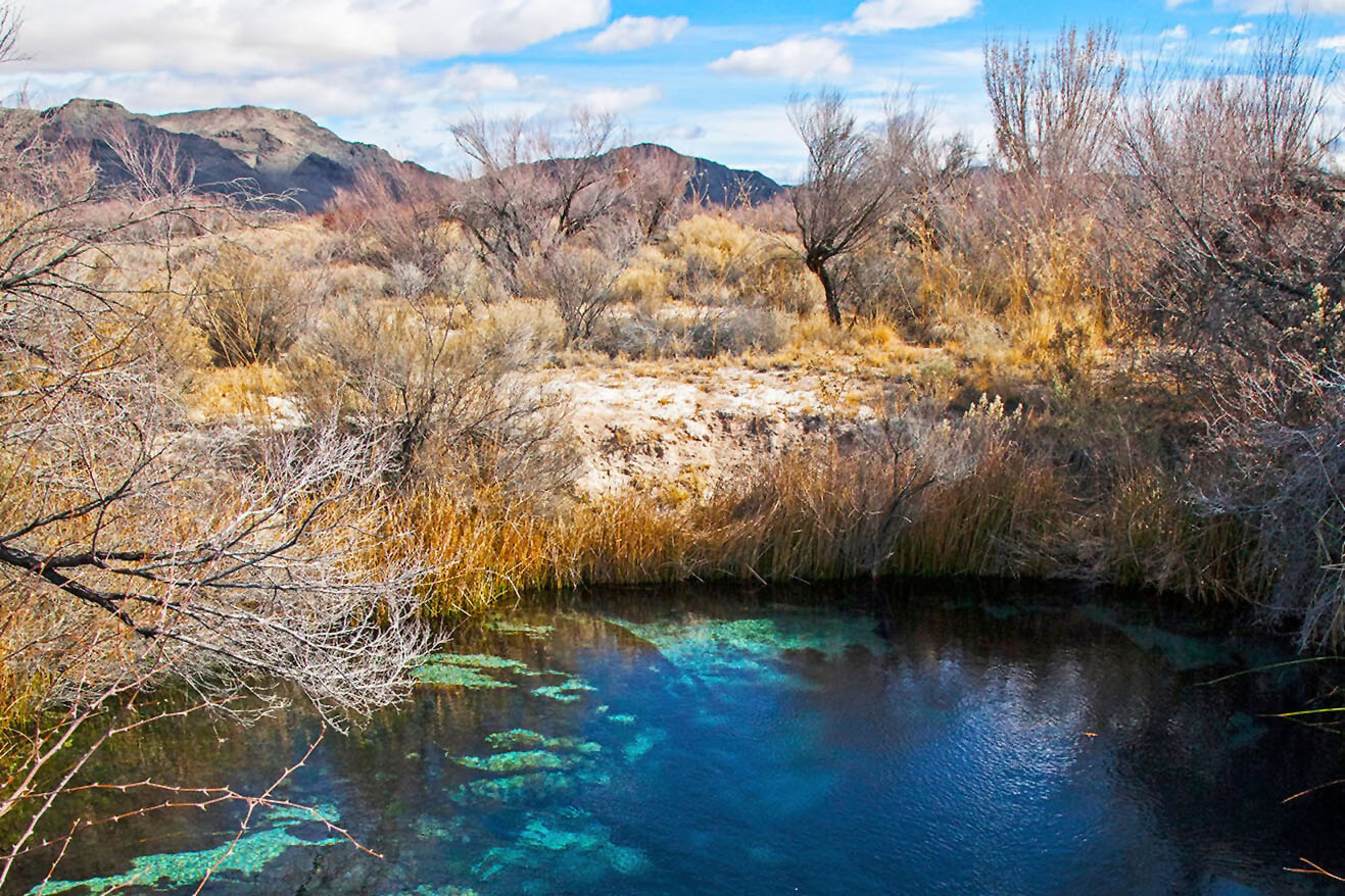
Crystal Springs in the Ash Meadow National Wildlife Refuge. Photo by Pahrump Photography
by Robert Marcos
The water in Amargosa Valley is a scientific oddity in that it serves as a living time capsule, and it supports life in one of our planet’s harshest environments. The Amargosa River flows underground for roughly 185 miles – surfacing only occasionally to create lush oases in the Mojave Desert.
Here are some remarkable aspects of this unique water system:
Ancient “Fossil Water”: Much of the groundwater in the Amargosa Basin is fossil water that was recharged during the last Ice Age, between 10,000 and 100,000 years ago. The water travels through a massive regional aquifer of limestone and dolomite rock from sources as far away as the Spring Mountains.1
A “Bottomless” Cavern: The system feeds Devils Hole, a water-filled limestone cavern in the Ash Meadows National Wildlife Refuge. Divers have never found its bottom, but it has been explored to depths of over 500 feet.
Geological Sensitivity: The water level in Devils Hole is so precisely tuned to the Earth’s crust that it acts like a giant seismograph. Massive earthquakes thousands of miles away in Japan or Mexico have caused “tsunamis” several feet high inside this tiny desert pool.2
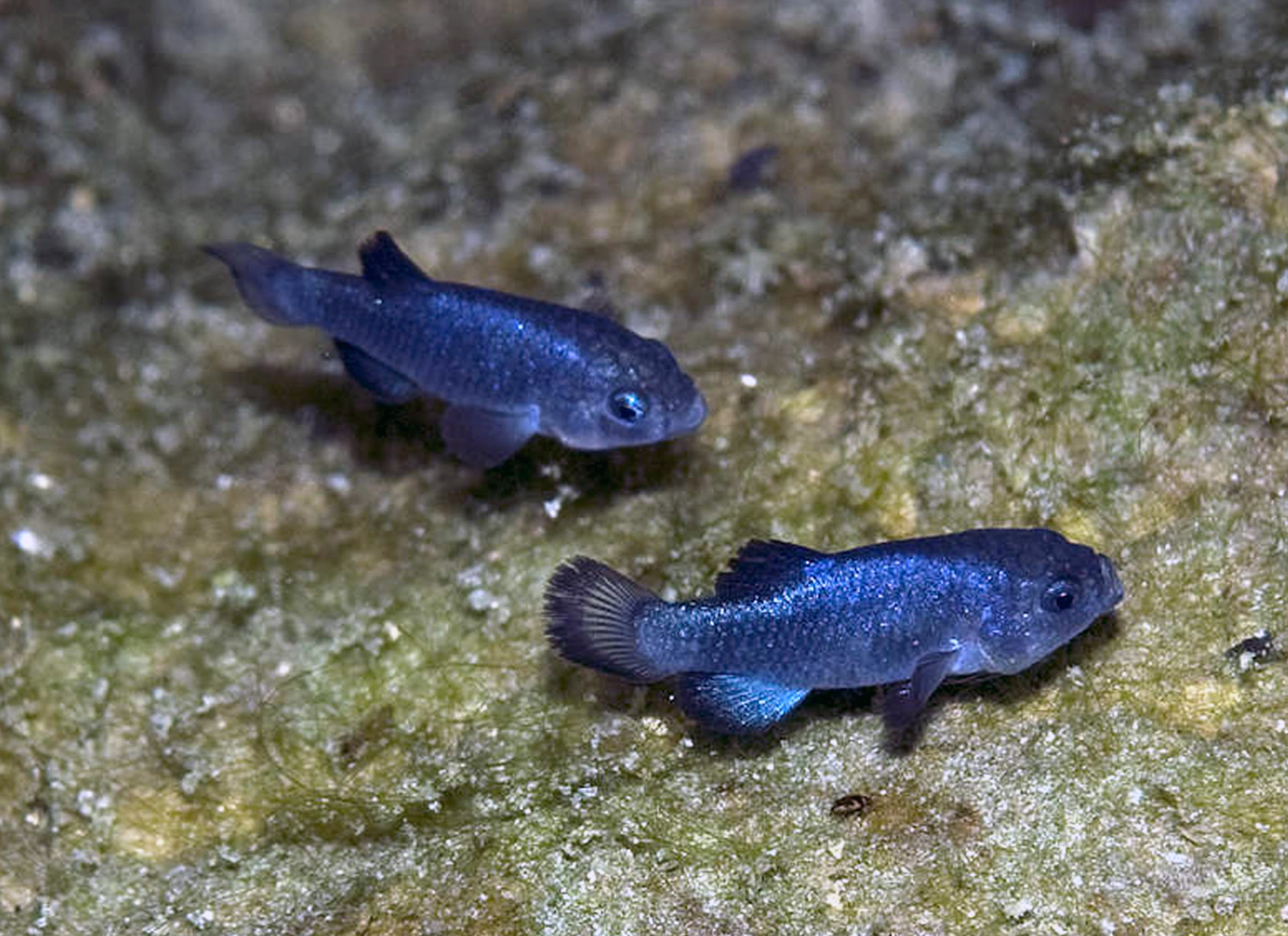
Two male Devils Hole Pupfish. Photographed by Olin Feuerbacher / USFWS
Extremophile Habitats: The valley’s springs support the Devils Hole pupfish, which has the smallest habitat of any vertebrate species on Earth. These fish survive in water that is 93°F and nearly devoid of oxygen, conditions that would be lethal to most other fish. The pupfish are closely monitored by an interagency group – consisting of the U.S. Fish and Wildlife Service, the National Park Service, and the Nevada Department of Wildlife. Scientists from these agencies frequently count the number of fish, collect their eggs, and are are undertaking captive rearing and “population augmentation” (which means they release captive-bred fish into the water in order to support the existing population, which is struggling).
Global Biodiversity Hotspot: Ash Meadows National Wildlife Refuge is home to 26 endemic species of plants and animals that exist nowhere else on Earth. This high concentration of unique life, isolated in “islands of water” within the Mojave Desert, has earned the area the nickname “The Galapagos of the Desert”. The endangered fish include the Devils Hole pupfish, Warm Springs pupfish, Ash Meadows Amargosa pupfish, and the Ash Meadows speckled dace. Several unique species of endemic plants include the Amargosa niterwortthe Ash Meadows milkvetch, the Ash Meadows blazingstar and Spring-loving centaury.3
Deep-Fault Thermal Springs: The heat in local thermal springs, such as those near Tecopa, is likely caused by deep water circulation along faults rather than a shallow volcanic heat source. The geothermally-heated water in the Amargosa Valley – including the water at Devils Hole, is heavily influenced by the region’s limestone and dolomite bedrock. As rainwater from the nearby Spring Mountains moves through deep underground fractures, it is heated by the Earth’s core and dissolves various minerals along the way.4
Widespread soaking rains fell across Texas and the Deep South, bringing a much needed moisture boost to these drought stricken areas. While sufficient to ease drought conditions across portions of Texas, the lower Mississippi Valley, and the Tennessee Valley, drought conditions remained mostly unchanged across southeastern Alabama, Georgia and northwestern Florida, where soil moisture and streamflows remain extremely low. Lighter rainfall also overspread the Northeast, which, combined with cooler temperatures helped slow the advancement of drought, and improved drought conditions in Maine. Where lighter accumulations occurred, there was slight expansion of drought and abnormal dryness across portions of the mid-Atlantic, Hudson Valley, and southeastern New England. Cooler temperatures and mostly dry weather overspread the Plains and Midwest. While drought conditions continued to expand across the Plains, the drier weather was mostly welcome across the upper Midwest and Corn Belt, allowing fieldwork to progress. Hot, dry weather promoted degradation across Arizona and northwestern Washington, while late season moisture across northern California did little to change the meager snowpack conditions…
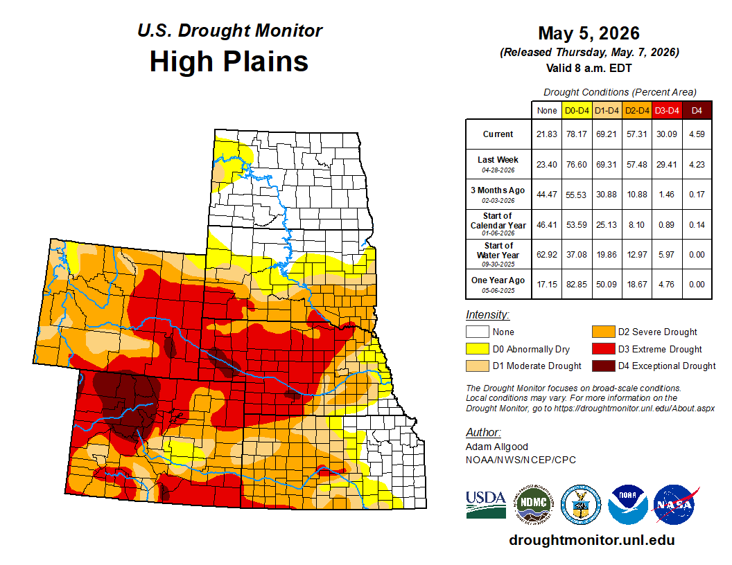
Light to moderate precipitation overspread much of the High Plains, with the heaviest accumulations (0.5 – 1.5 inch) falling across central Colorado, including late season snow across the higher elevations. This precipitation resulted in some drought reduction across central Colorado. Across the rest of the Plains, however, the moisture was not sufficient to engender substantive improvements. Despite cooler temperatures lowering evapotranspiration rates, some degradation occurred across Kansas and Nebraska, and far western North Dakota…
Colorado Drought Monitor one week change map ending May 5, 2026.
Outside of northern California, where late season moisture provided a boost to short-term streamflows and soil moisture but did little to change the unusually low snow cover across the northern Sierras, seasonably dry weather overspread most of the West. Recent moisture eased drought conditions across far western Montana. While little change to the drought depiction occurred across the West, hot, dry conditions exacerbated impacts across Arizona, resulting in some substantial degradation. Short term dryness also increased across northwestern Washington, resulting in expansion of D0.
Following last week’s beneficial rainfall, additional rain overspread much of Texas and Louisiana over the last several days, sparking additional drought reductions. Rainfall across central and western Texas eased drought across the upper Rio Grande Valley as well. Despite the beneficial rainfall, widespread severe to exceptional drought continues across the South Region, and it will take a sustained series of heavy precipitation events to begin any widespread easing of impacts. The beneficial rainfall missed the Texas Panhandle and western Oklahoma, where poor conditions continue to affect rangeland and winter wheat. Drought conditions also expanded across Arkansas…
Looking Ahead
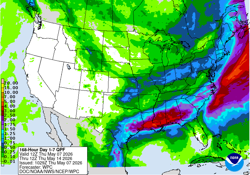
During the next 7 days, an active pattern is favored to continue across the Southeast, with heavy rainfall (2 – 7 inches) possible along a swath from eastern Texas through southern Alabama. These rains would continue to bring drought relief and also a threat of severe weather. Lesser accumulations are favored across Georgia and Florida, which may limit the extent of any improvements. Widespread precipitation is also favored along the Ohio Valley and across the eastern seaboard, with the greatest potential for relief across the Northeast. Somewhat drier conditions across the mid-Atlantic may limit the potential for drought improvement. Light accumulations forecast across the Plains may do little to ease drought conditions, while another week of seasonable dryness is forecast across the West. Above-average temperatures across the West favor an acceleration of snowmelt, which may bring short term reservoir boosts but leaves the water supply even more short as summer approaches. Below-average temperatures are favored for the eastern half of the CONUS.
During the 8-14 day period, above-average temperatures are favored for much of the lower-48, with near normal temperatures forecast for the Northeast. Above-average precipitation is forecast for the southern tier, with the highest probabilities across Texas, eastern New Mexico, and Louisiana. A slight tilt towards above-normal precipitation extends across the Great Lakes Region into the Northeast, while below-average precipitation is favored for the northern Rockies.
US Drought Monitor one week change map ending May 5, 2026.
Click the link to read the discussion on the CBRFC website:
The Colorado Basin River Forecast Center (CBRFC) geographic forecast area includes the Upper Colorado River Basin (UCRB), Lower Colorado River Basin (LCRB), and Eastern Great Basin (GB).
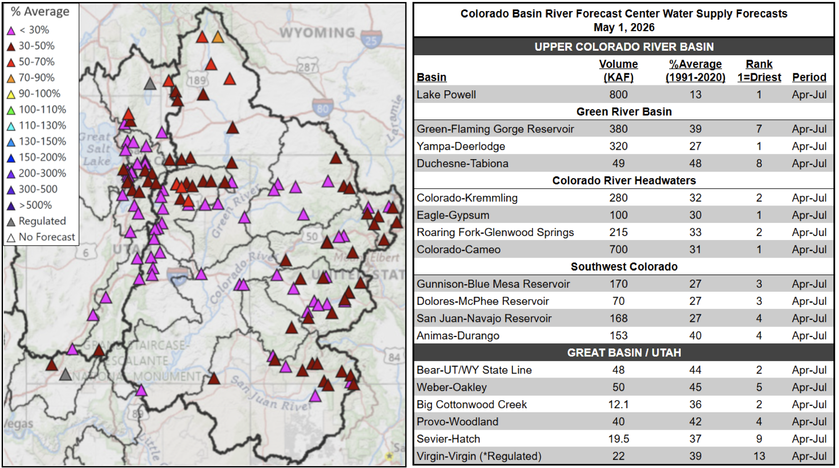
Water Supply Forecasts
April-July volume forecasts are well below normal and rank in the driest five on record at many locations. Record low snowpack and poor soil moisture conditions are the primary hydrologic conditions impacting the water supply outlook, while future weather is a primary source of forecast uncertainty. May 1 water supply forecasts are summarized in the figure and table below.
May 1, 2026 seasonal water supply forecast summary.
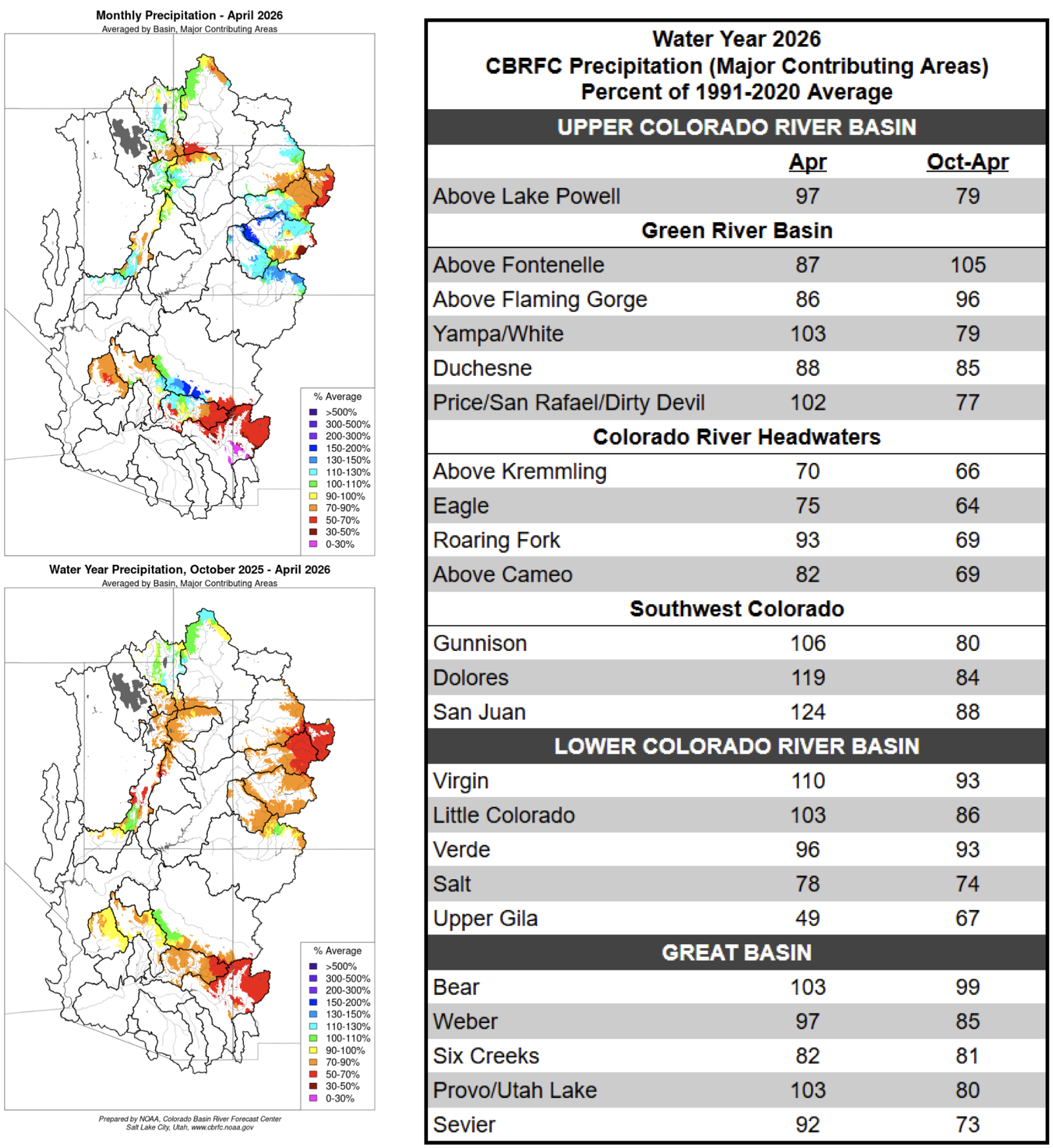
Water Year Weather
The 2025–26 meteorological winter (December–Februrary) was the warmest winter on record for vast swaths of the CBRFC area. It was the driest March on record at numerous SNOTEL sites across the CBRFC area, and an unprecedented heatwave during the last half of March led to significant snowmelt. April weather was cooler and wetter compared to March, with most areas receiving near normal April precipitation. The figures and table below summarize water year 2026 precipitation.
Water year 2026 precipitation summary.
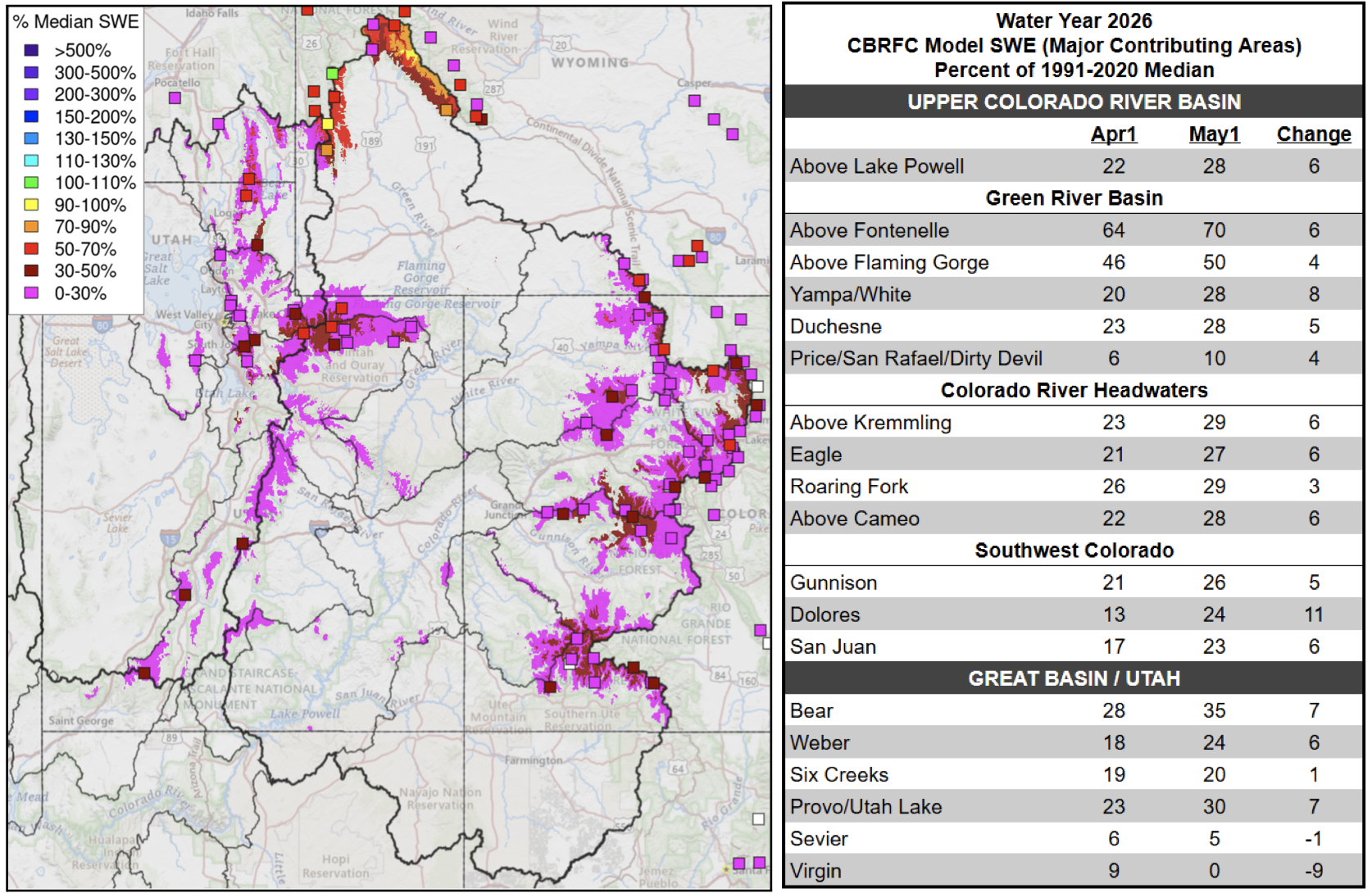
Snowpack Conditions
Snow water equivalent (SWE) has been tracking at or below record low for the past several months. The significant heatwave during the last half of March led to historically low April 1 snow water equivalent conditions across the region. An early April NRCS-Utah Snow Survey Special Report stated that “at no time since systematic snowpack measurements began around 1930 has April 1 snowpack been this low in the state of Utah, and 2026 SWE is roughly five times lower than the previous record low” . A similar analysis performed in early April by the Colorado Climate Center concluded that “this has been the worst year for Colorado snowpack in recorded history, and most locations have less than half of the previous record low”
Precipitation during April led to modest snow accumulation and reduced snowmelt rates due to cooler and cloudier weather. However, May 1 SWE remains at record low values at many SNOTEL stations across UT, WY, and CO. May 1 SWE across the UCRB and GB is generally less than 30% of normal and below the 10th percentile. SWE conditions are more favorable, but still well below normal across northern areas including the headwaters of the Upper Green and the Bear River Basin. SWE conditions are summarized in the figure and table below.
Left: May 1, 2026 SWE – NRCS SNOTEL observed (squares) and CBRFC hydrologic model. Right: CBRFC hydrologic model SWE conditions summary.
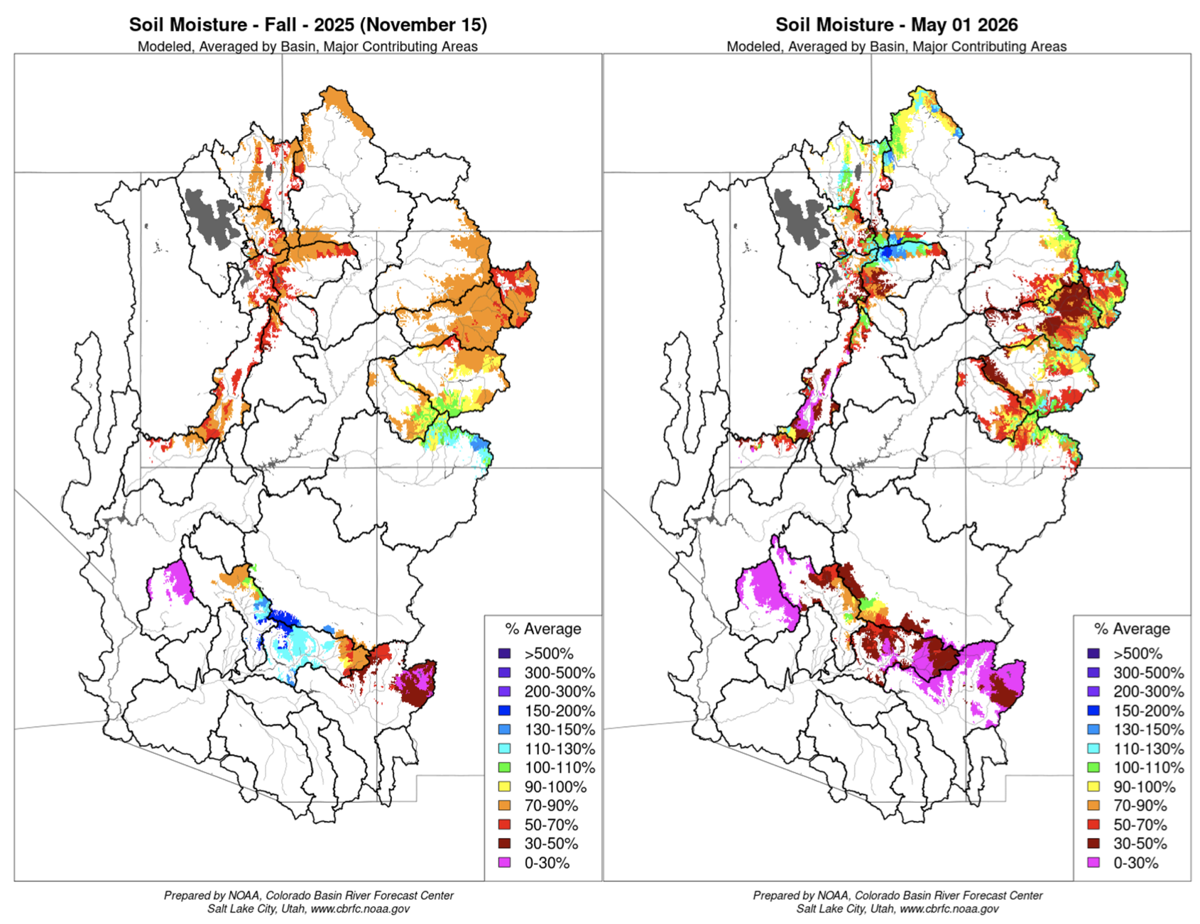
Soil Moisture
CBRFC hydrologic model soil moisture conditions impact water supply forecasts. Basins with above average soil moisture conditions can be expected to experience more efficient runoff from rainfall or snowmelt while basins with below average soil moisture conditions can be expected to have lower runoff efficiency until soil moisture deficits are fulfilled. The timing and magnitude of spring runoff is impacted by snowpack conditions, spring weather, and soil moisture conditions.
Mid-November 2025 soil moisture conditions were below normal across most areas as a result of warmer and drier than normal weather during the 2025 water year. Higher elevation soil moisture/baseflow conditions typically don’t change much during winter months as snow is accumulating. However, this has not been the case this season. Early April CBRFC model soil moisture conditions were generally above average due to snow melt that occurred during the late March heatwave. Early May soil moisture conditions are generally below average across lower elevations, with near average soil moisture conditions across higher elevations. CBRFC hydrologic model soil moisture conditions are shown in the figures below.
CBRFC hydrologic model soil moisture conditions as a percent of the 1991–2020 average – Mid-November 2025 (left) and early May 2026 (right).
Upcoming Weather
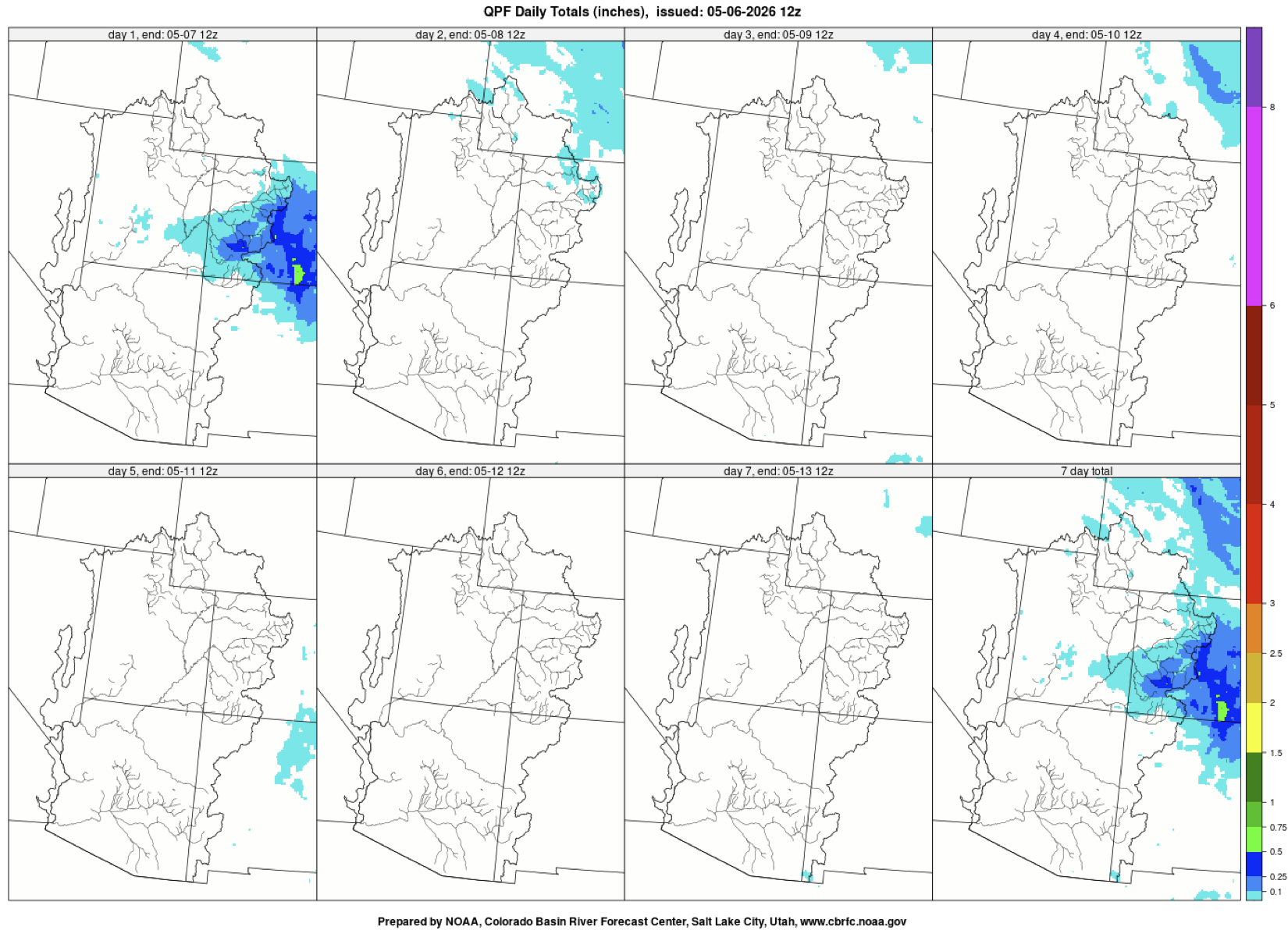
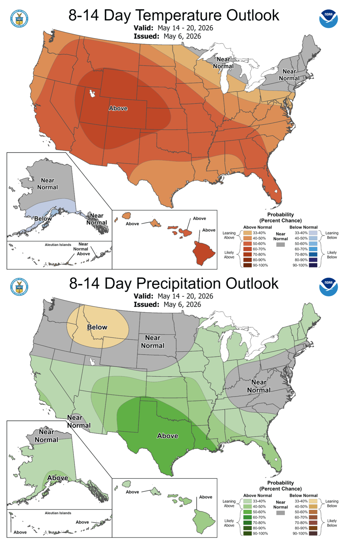
Weather during the first week of May has been unsettled across the CBRFC area, including a significant winter storm across the mountains of Wyoming and Colorado. Warmer and drier conditions will develop in the coming days. The 7-day precipitation forecast and the Climate Prediction Center (CPC) 8–14 day temperature and precipitation outlooks are shown in the figures below.
7-day precipitation forecast for May 6–12, 2026.
Climate Prediction Center precipitation and temperature probability forecasts for May 14–20, 2026.
A (presumably) autonomous mine haul truck at Mariana Mineral’s newly acquired Lisbon Valley copper mine in southeastern Utah. Jonathan P. Thompson photo.
Every six months or so I like to do a recon of the Lisbon Valley in southeastern Utah, a long-time sacrifice zone for uranium and copper mining, oil and gas drilling, natural gas processing, and now lithium extraction — not to mention cattle grazing — to see about the latest developments. My takeaway from my latest visit: The sacrifice continues — both in a real sense and a speculative one.
The speculation is in the form of a rush to stake mining claims on nearly every inch of available public land in the valley. This phenomenon isn’t readily apparent on the ground, but showed up indirectly in the form of orange No Trespassing signs posted on public roads in one specific area. Except they aren’t really prohibiting trespassing — that would be illegal. They are just pointing out that the Lisbon Valley Mining Company has already claimed all of the public land around there, so new would-be claimants should just stay away.
Photo credit: Jonathan P. Thompson
Meanwhile, after shutting down in 2024 due to high costs and staffing challenges, the Lisbon Valley copper mine, which posted the signs, is back in business. Late last year Mariana Minerals, backed by the Silicon Valley venture capital firm Andreessen Horowitz, purchased the then-idled mine. Mariana’s CEO is Turner Caldwell, who previously ran Tesla’s battery minerals unit. Perhaps it was his cybertruck that sat in the mine’s parking lot when I drove by recently.
At the mine’s grand reopening ceremony last month, Caldwell said he was hoping to “fundamentally reinvent how infrastructure is built, how mines are operated and how refineries are operated.” This includes using autonomous drills, equipment, and haul trucks, as well as robots to do inspections and conduct more hazardous work.
This purportedly will allow the operation to increase production from about 2,500 tons annually under the previous ownership, to a target of 50,000 tons per year by 2030 — an enormous jump. Historically, the most the mine produced was about 10,000 tons annually. But last year the BLM approved the company’s proposed expansion of its open pit operations and to add an in-situ extraction operation — a prospect that alarmed nearby residents concerned about contamination of aquifers.
Caldwell is vague about the number of jobs the revived operation will create. On the one hand, he’s said he plans on hiring “hundreds” of new workers and invest over $1 billion. On the other, the autonomous equipment’s main asset is that it alleviates past staffing difficulties. As of early May, the Mariana website advertised just 19 open jobs at the Lisbon Valley site. That includes several salaried positions, with pay ranging from $100,000 to about $180,000 per year, as well as drillers, equipment operators, and mechanics at $25 to $45 per-hour wages. Interns could earn $30/hour.
Whether any of that will be enough to afford housing in Moab or even La Sal or Monticello is unclear.
I passed through there on a Sunday, and things were quiet. One haul truck was sitting in the pit, and it appeared as if it was running but it wasn’t doing any hauling. I couldn’t get close enough to confirm that there was no human driver, but the cab did look empty. There were no robots in sight.
Meanwhile, down in Arizona’s copper country, the Center for Biological Diversity, the San Carlos Apache Tribe, and the Lower San Pedro Watershed Alliance filed an intent to sue the Trump administration over its approval of Faraday’s Copper Creek exploratory drilling project east of Mammoth, Arizona, saying it violates the Endangered Species Act.
The exploratory project, a precursor to actual mining, includes 67 drill pads, along with associated roads and infrastructure, on about 78 square kilometers in the Galiuro Mountains in the Lower San Pedro Watershed. Each drill rig requires tens of thousands of gallons of water in an area where communities are facing water shortages and the riparian ecosystem is stressed by prolonged drought. The groups’ lawsuit focuses on the drilling’s impacts on the imperiled Mexican spotted owl and other wildlife.
“The Lower San Pedro watershed is one of Arizona’s most important wildlife corridors, and this exploration project is pushing industrial disturbance into a landscape that is already under pressure,” said Melissa Crytzer Fry, chair for the Lower San Pedro Watershed Alliance. “When agencies ignore clear evidence and fail to follow the law, local communities are left to defend the river, the habitat and the species that make this place irreplaceable.”
🐟 Colorado River Chronicles 💧
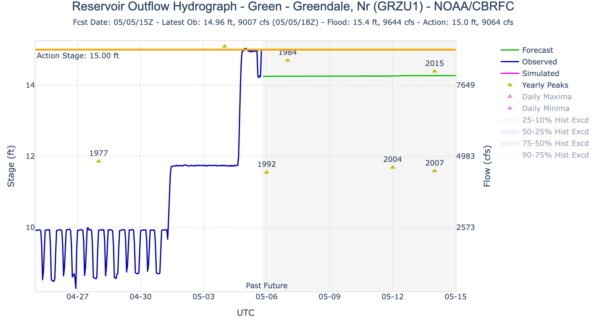
If you’re bummed out about the reduced releases from Glen Canyon Dam — and the associated drop in streamflows in the Grand Canyon — you might try going upstream a ways and boating the Green River or the Colorado River below the confluence of the two. On May 1, the Bureau of Reclamation upped releases from Flaming Gorge Dam to full power plant capacity, or 4,600 cubic feet per second. Then, on May 4, they started allowing an additional 4,000 cfs to flow through the dam’s bypass to implement a larval trigger study plan (and to bolster Lake Powell’s levels).
Hydrograph showing releases from Flaming Gorge Dam. On May 1 they jumped to 4,600 cfs and then again increased to about 9,000 cfs on May 4. Source: NOAA/CBRFC
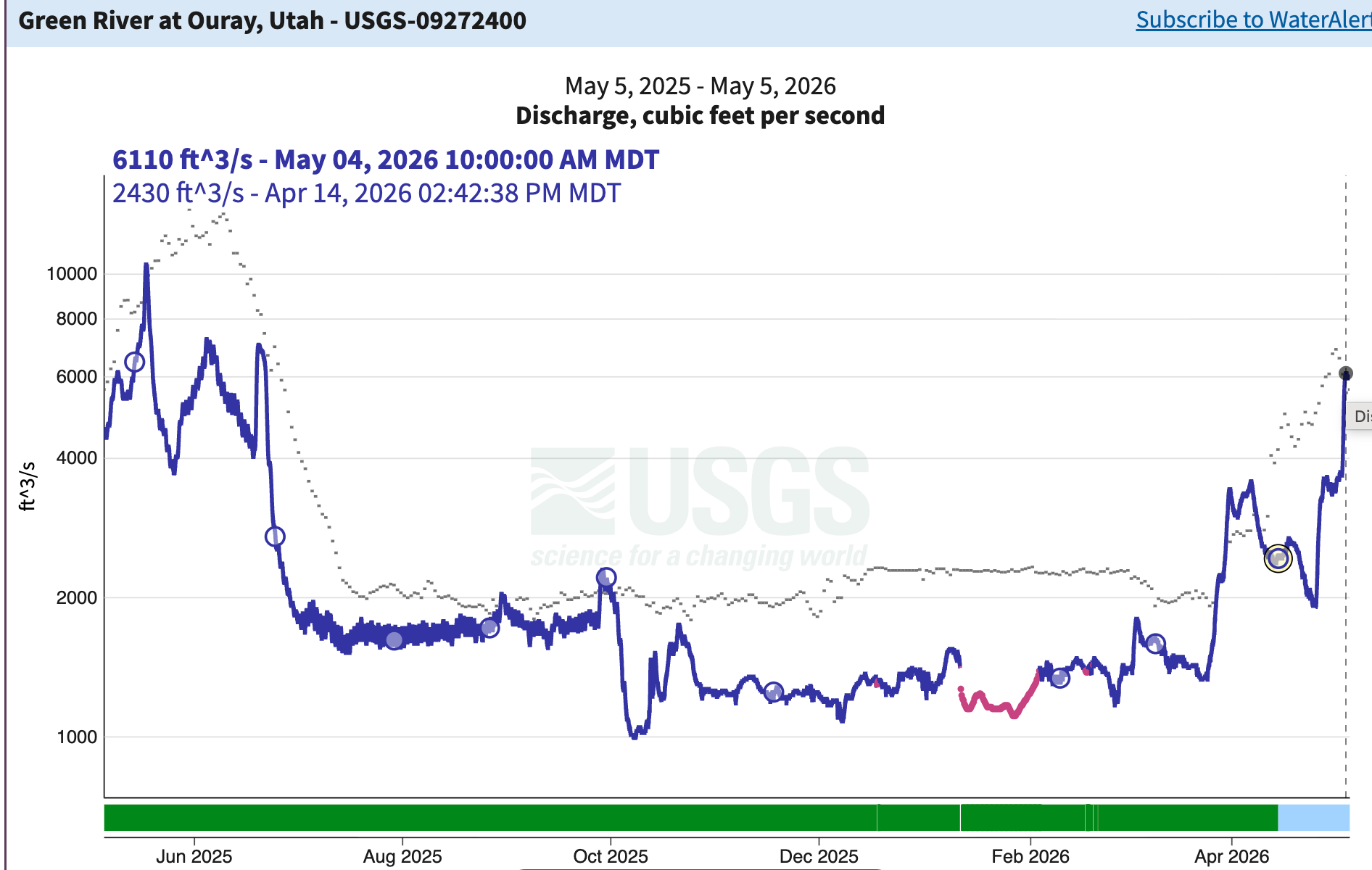
Today (May 5) the Bureau was releasing about 9,000 cfs from the dam. While the first pulse (the May 1 release) has made it downstream, the second one has yet to reach Ouray, Utah, if the USGS streamflow gage is any indication. But as that 9k cfs makes it downstream, it should make for some good boating — or at least better than you’d expect during such a dry year — not only on the Green, but also in Cataract Canyon. Whether it will bail out Lake Powell is another question altogether.
The Green River’s “natural” spring runoff occurred in late March and early April. Now an artificially induced one is in its full throes. Whether it will be larger than last year will be determined in the next couple of weeks. Source: USGS.
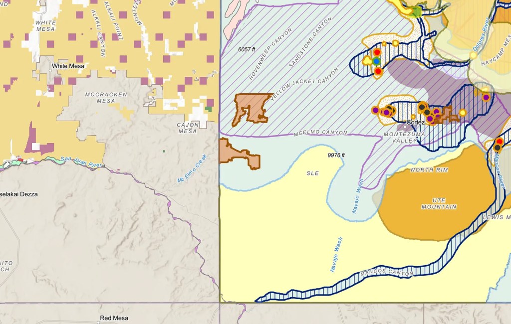
🗺️ Messing with Maps 🧭
A couple of weeks ago I wrote about the Trump administration’s mapping tool, aimed at making America graze again, showing “potentially available” (i.e. vacant) grazing allotments on public lands. Now the mapping folks at Center for Biological Diversity have taken that map, and overlain it with areas of endangered species’ critical habitat and BLM allotment health status. It can be a little overwhelming to navigate because of all the different layers and colors. But you can turn layers on and off to make it easier to use, and it’s valuable for just understanding the landscape in general.