The Roaring Fork River in Aspen on July 8. Pitkin County Commissioners gave initial approval to buying more shares of Twin Lakes water to boost low flows on the Fork. CREDIT: HEATHER SACKETT/ASPEN JOURNALISM
Against the recommendation of an advisory board, Pitkin County commissioners on Wednesday gave preliminary approval to buy more water to boost flows in the often-depleted Roaring Fork River.
Commissioners approved on first reading a resolution and ordinance to spend $442,500 to buy 4.68 shares from the Twin Lakes Reservoir & Canal Co., which is about 3.5 acre-feet of water, according to a staff memo. The deal is in addition to the $6.5 million Pitkin County already agreed to spend earlier this year for about 71 acre-feet from Twin Lakes and another ditch company.
Twin Lakes collection system
The water is currently taken across the Continental Divide to the Arkansas River basin to be used by entities on the Front Range. The deal would allow the water to be released out of Grizzly Reservoir to Lincoln Creek and could help boost the Roaring Fork through Aspen and upstream, which suffers from low flows in dry years.
“I think it’s really critical that we purchase water rights when we can, and this is an opportunity that we can, and we should,” District 1 Commissioner Patti Clapper said.
Pitkin County has long had a goal of increasing the amount of water in the Roaring Fork, a river that has about 40% of its headwaters diverted to the eastern side of the state through the Independence Pass Transmountain Diversion System to be used by Colorado Springs, Pueblo and Aurora. These diversions can often contribute to the depletion of the Roaring Fork through Aspen, and purchasing Twin Lakes water represents a rare opportunity to return water to the Western Slope.
Commissioner Greg Poschman said he supports acquiring the water shares.
“I think it’s great that we are doing this,” he said. “I know it’s expensive; there are some raised eyebrows about that, but I think this is something we have to do.”
Poschman added that he was concerned that the Healthy Rivers board members recommended against buying more water and said he would like to fully understand their reasons. County staff said they were trying to schedule a joint meeting with the Board of County Commissioners and the Healthy Rivers board in August.
Members of the county’s Healthy Rivers board, which advises the BOCC, are concerned that the water will have a small impact on river health but a big impact on the program’s budget. The board held a special meeting June 25 to consider acquiring the shares and approved a motion saying the water yield would potentially be only 1 additional cubic feet per second for two days.
“Additionally, the deleterious effects of the purchase price on the long-term fund balance of the Healthy Rivers Fund will reduce the Healthy Rivers Program’s ability to support programs to address other ballot measure mandates, including water quality, ecological health, recreation opportunities, wildlife and riparian habitat, and promoting water conservation,” the motion reads.
The motion goes on to say that in the future, the county should implement a framework for evaluating the true value of water shares to the Roaring Fork.
At Wednesday’s meeting, County Budget Director Connie Baker told the BOCC that the Healthy Rivers board will have to trim or reallocate about $500,000 from next year’s budget to account for the combined impact of this year’s two water purchases.
Healthy Rivers board member Ned Andrews said he is against the purchase, citing the impact that it will have on the program’s budget.
“None of the analysis or details that would justify such a purchase or a strategy going forward has been done,” Andrews told Aspen Journalism. “I think before you commit essentially a quarter of your budget for the next 15 years, you’d want to have an analysis that shows you what could be accomplished. My gut feeling is that it wouldn’t really accomplish much.”
Andrews also opposed the earlier, larger water share purchase, although the rest of the Healthy Rivers board was supportive.
At their regular June meeting, Healthy Rivers board members went through the budget line by line and considered where they could trim, although those cuts have not yet been finalized.
Spending big bucks in an effort to rescue rivers is not new for Pitkin County, which has spent at least $3.5 million on the Roaring Fork River Park in Basalt, including a water court battle to secure the water right for recreation, several redesigns of problematic waves, and improvements to the riverbank and boat launch.
Grizzly Reservoir, a forebay that collects water to send through the Twin Lakes Tunnel to the Front Range, sits in the middle of the Lincoln Creek watershed and connects water users on both sides of the Continental Divide. Pitkin County commissioners gave initial approval to a deal that would allow more water to be released from Grizzly for the benefit of the Roaring Fork. CREDIT: HEATHER SACKETT/ASPEN JOURNALISM
Bond for original purchase approved
The BOCC at Wednesday’s meeting also approved issuing a bond for the original purchase of Twin Lakes shares. That deal cost the county $6.5 million, although only 45 of those acre-feet represent Western Slope water that is currently diverted to the Front Range. The county plans to sell or trade the other 26 acre-feet, which is owned by the Fountain Mutual Ditch Co. in El Paso County and decreed for use on the east side of the divide.
The 45 acre-feet of water can be released down the Roaring Fork during the irrigation season when flows are low, and it must be used by a downstream water user on the Colorado River before the town of DeBeque. Instream flow for the benefit of the environment is not a decreed use of the water.
This year, according to Colorado Water Resources Division 5 Engineer Tyler Benton, at least some of Pitkin County’s Twin Lakes water was released as part of the Colorado River Water Conservation District’s emergency substitute water supply plan, which the district enacted in response to this year’s historic drought. Benton said he expects the River District to provide a full accounting of how much Pitkin County water has been released Friday.
Grizzly Reservoir is currently drained for dam maintenance, which may have affected how much water could be released under the River District’s plan.
At a time when drought impacts are being acutely felt across the state and climate change continues to rob rivers of their flows, for some, the unique opportunity to put water back into a depleted stream is worth the cost.
“This is expensive water, but it’s the only water you can get up at the headwaters of the Roaring Fork,” said Pitkin County Deputy Attorney Anne Marie McPhee. “So that scarcity makes it more valuable.”
The issue is scheduled for a public hearing and second reading July 22.
A new Colorado law requires water users that buy water tied to farms in the Arkansas Valley to revegetate land before using water elsewhere…
“When that water leaves, the impacts of the dry-up don’t leave with it. They stay with the land and the people who live here,” said Jack Goble, general manager of the Lower Arkansas Water Conservation District, which advocated for the legislation.Revegetation involves restoring native plant cover to the land to reduce erosion, maintain soil moisture and manage noxious weeds…
In Crowley County, where productive farmland has declined by more than 90% since the 1970s because of water transfers, so-called “buy-and-dry” transactions have spawned a sea of dirt that supports little more than weeds. According to a recent report from ProPublica, these water transfers have caused an “environmental catastrophe,” in Crowley County, in which birds, bees and wildlife have fled. A 2026 report from Colorado State University estimates that every acre of irrigated land taken out of production leads to an annual economic loss of $1,400 to $1,600. Governor Jared Polis (D) signed House Bill 26-1340 into law June 1. The new law, sponsored by representative Ty Winter (R), gained broad support in the House and Senate. The law takes effect January 1, 2027.
“If you look at other natural resources — coal, gravel, oil and gas — when that’s mined from the land the requirement is on the entity that profits off of, and mines that, to go and reclaim that land. We think water should be no different,” Goble said.
Southeastern Colorado’s farmers and farming communities say they’ve won valuable protections against the historic worst practices of cities’ “buy and dry” of agricultural water, after final passage of revegetation requirements along the Lower Arkansas River that may spread to other basins of the state.
“For the first time in Colorado, this new law establishes that when irrigation water is permanently removed from farmland for other uses, the responsibility to properly revegetate and reclaim that land belongs to the entity removing the water,” said Jack Goble, general manager of the bill’s primary advocate, the Lower Arkansas Valley Water Conservancy District.
“It also strengthens the role of local counties by requiring the water court to incorporate their revegetation criteria and enforcement mechanisms into change-of-use decrees. At its core, this law sets clear expectations, creates accountability and helps protect the land, neighboring landowners and rural communities that are left behind when water leaves,” Goble said.
Southeastern Colorado advocates conceded some measures after the bill’s introduction.
The original bill limited a water use transfer to 50% of the purchased water until 50% of the affected farmland had been successfully revegetated against erosion and deterioration. The bill as passed removes the hard percentage, and gives city water agencies more flexibility when they buy, such as posting a bond or negotiating conditions during local permit applications.
The initial bill language had a hard requirement for a five-year water court oversight of revegetation after a rights transfer to guarantee reclamation. The bill as passed gives water courts the ability to create an oversight period, but only when there is “a substantial risk that reclamation could regress,” Goble said.
The final bill gives assurances to Arkansas Valley communities by requiring any reclamation agreements with cities to be written into change-of-use decrees, after the details have been negotiated by an intergovernmental agreement in a permit.
“Colorado agricultural lands are vital to our economy and way of life in Colorado, and protecting Colorado lands from the impacts of drought, erosion and invasive weeds is important to protecting our natural resources and our communities. The governor will review the final version of the bill,” spokesperson Ally Sullivan said.
Aurora Water officials, from one of the Front Range water agencies that has traveled far for decades to acquire river rights and agricultural water rights, said they support concepts in the legislation, but have reservations about how it might be executed.
“Aurora Water has actively worked in the Lower Arkansas Valley for decades, including opening an office in Rocky Ford in 1988 with full-time staff dedicated to supporting long-term revegetation and land stewardship efforts after water has been removed from agricultural production,” said Aurora Water spokesperson Shonnie Cline. “In many respects, House Bill 1340 was largely modeled after practices Aurora Water has implemented in the region, and we strongly support the overall intent of the legislation.”
Cline said Aurora Water backs responsible reclamation, and “at this time, we do not anticipate the bill significantly changing Aurora Water’s current operations in the region.”
Aurora Water is much less enthusiastic about potential future legislation applying the new southeastern Colorado protections to other river basins in the state.
“Aurora Water would have concerns with any future expansion of this type of legislation into other regions of the state as it could unintentionally harm existing dryland farming operations or create disincentives for farmers who are successfully operating under dryland agricultural practices on converted lands,” Cline said.
“Additionally, Aurora Water believes it is important for water courts to retain the authority to independently evaluate whether revegetation or dryland farming standards to be incorporated into a court decree are technically appropriate, scientifically supported and feasible under the specific facts of each case, regardless of where the standards originate.”
Controversy over what happens to former farm and pasture land when a distant city dries it up has hit other parts of Colorado beyond the Lower Arkansas River, including Thornton’s purchase of thousands of acres of water rights in Weld and Larimer counties. Thornton has tried to placate the counties with commitments to revegetate or promote responsible dryland farming when it starts taking water off the acreage and putting it into an under-construction pipeline.
Aurora and Colorado Springs have faced decades of criticism from southeastern Colorado counties for past purchases and dry-ups that left areas like Crowley County looking like Dust Bowl victims. More recent farm water purchase agreements in places like Bent County limit the number of years in a row a city could take farm water, and make other concessions to try to support local economies.
Colorado Springs Utilities said after the bill’s final passage, “We recognize that revegetation of formerly irrigated lands is a fundamental requirement for any water transfer.”
“We strive to forge mutually beneficial partnerships in the Arkansas River Basin, which is why our team spent over three years negotiating terms and conditions for our water projects in Bent County,” Colorado Springs officials said, in a statement.
Colorado Springs officials said they appreciated the negotiations over House Bill 1340 for “taking these concerns seriously so that we could reach a compromise on the introduced bill that upholds our local agreements. … We believe that reliance on science and collaboration with local governments allows projects to be tailored to unique community and regional needs.”
The western stretch of the Arkansas River, which flows from its headwaters in the Rocky Mountains across the plains of southeastern Colorado, is in trouble. That trouble is compounded by uncertainty about what, exactly, is polluting and drying the river, and how such problems can be fixed.
Overshadowed by the ongoing political brawl over the Colorado River, the Arkansas River Valley rarely appears in national news. But since Dec. 30, when President Donald Trump vetoed a bipartisan bill that would have secured favorable terms for funding to complete a $1.39 billion, 130-mile water pipeline, the region has become the stage for yet more drama about water in the Western U.S.
Arkansas Valley Conduit map via the Southeastern Colorado Water Conservancy District (Chris Woodka) June 2021.
The Arkansas Valley Conduit is part of a decades-long effort to replace the dwindling, contaminated water in this stretch of the Arkansas Valley with clean water from Colorado’s Western Slope and the Pueblo Reservoir. If completed, it will supply water to roughly 50,000 valley residents, many of whom can no longer count on municipal supplies for safe drinking water.
Pundits portrayed Trump’s veto as retaliation against Colorado politicians: Republican Rep. Lauren Boebert, who helped force the November vote for the release of the Epstein files, and Democratic Gov. Jared Polis, who has resisted pressure to pardon Tina Peters, a county clerk in western Colorado convicted of tampering with voting machines during the 2020 election. Sens. Michael Bennet and John Hickenlooper, both Democrats, condemned the administration for “putting personal and political grievances ahead of Americans.” The Salida-based Ark Valley Voice declared a “Reign of Retribution Punishing Deep Red Southeastern Colorado.” The New York Times, emphasizing the same irony, observed that “A Trump Veto Leaves Republicans in Colorado Parched and Bewildered.”
For those managing the project, the veto is a setback but not a showstopper. The first dozen miles of the conduit have already been completed, and enough capital is on hand for at least three more years of construction. “Some (coverage) has been saying it’s the end of the project, which is totally false,” said Chris Woodka, senior policy and issues manager of the Southeastern Colorado Water Conservancy District. “It’s still being built; the veto was not for any reason that had anything to do with the project, and we’re working in every way we can to make this affordable.”
For valley residents, the issue is personal. This rural region is more culturally aligned with western Kansas than with Front Range cities. Like people throughout the Great Plains, the local residents are grappling with eroding social services and the rising cost of living. The scarcity of safe water magnifies uncertainty. “If you don’t have clean water,” said Jack Goble, general manager of the Lower Arkansas Valley Water Conservancy District and a sixth-generation rancher, “you really don’t have anything.”
“HOW EASY IT IS,” wrote William Mills in his 1988 book The Arkansas, “to take a river for granted.”
The Arkansas Valley of Colorado is the ancestral homelands of the Plains Apache, Comanche, Kiowa, Cheyenne and Arapaho peoples. A geographical corridor across the Southern Plains, it was a route for incursions and ethnic cleansing by non-Native fur trappers, traders, military expeditions, hide hunters, railroad developers and settlers. Those settlers include my ancestors; I grew up in southwest Kansas, where generations of my family farmed and ranched along the dry Cimarron River. The Arkansas Valley, with its dwindling water and flatlands, feels like home.
Straight line diagram of the Lower Arkansas Valley ditches via Headwaters Magazine
By 1900, settlers had diverted the Arkansas into a maze of ditches. Irrigation and migrant labor supported sugar beet factories, vegetable cultivation and Rocky Ford’s famous melons. Such practices remade the riverbed, increased salinity, and reduced flow. As with the Colorado River, water rights were assigned partly on wishful thinking. Today, the Arkansas Valley is one of the region’s most over-appropriated basins, and the river’s annual flow has dramatically declined. A short distance past the Kansas line, the river is entirely dry.
The Arkansas is being drained in new ways. Climate change and a record-breaking snow drought are intensifying the scarcity. Over the last half-century, growing Front Range cities have purchased water rights from farmers in the valley. Exchange agreements allow cities to swap these rights for ones farther upstream, leaving the downstream flow diminished and dirtier. Between 1978 and 2022, nearly 44% of the irrigated farmland in the Lower Arkansas Valley Water Conservancy District was taken out of production.
Rocky Ford Melon Day 1893 via the Colorado Historical Society
Critics call it “buy-and-dry.” They say the removal of water has disastrous consequences for an agricultural region. “If you take all of that water out of an economy that completely depends on it,” Goble said, “it just breaks a community.” Faced with the prospect of litigation from local water districts, cities like Aurora claim to be developing more sustainable arrangements.
THE ARKANSAS’ WATER is changing, too. The river is diverted into dozens of canals and fields. What doesn’t evaporate or get absorbed returns as runoff or sinks through the alluvial gravels that connect to the riverbed. Each time a drop of water returns, it carries more dissolved minerals. As the river’s volume lessens, the concentration increases in what is left. By the time the river reaches the Kansas border, the water regularly contains 4,000 milligrams or more per liter — making it about eight times saltier than a typical sports drink and unsuitable for growing many crops.
Minerals are not the only problem. The river basin and alluvial gravels are also contaminated with radium and uranium. Last year, a study by the Colorado Geological Survey found that the levels of radioactivity in more than 60% of the private wells sampled in the valley exceeded federal standards.
The radionuclides are called “naturally occurring.” But natural uranium usually stays locked in rock. In the valley, irrigated agriculture sets it into motion. Uranium is mobilized by complex interactions between oxygen, sediments, water, microbes and nitrate. Nitrate is a common fertilizer. One study found that valley farmers had over-applied it for decades. This pulls out radionuclides, turns them loose, and flushes them into the river’s shallow aquifer. Levels rise as the river moves east through agricultural lands.
Contamination is not news in the valley. People have worked on cooperative solutions for decades. To meet safe water standards while the conduit is under construction, the towns of La Junta and Las Animas installed filtration systems. But cleaning the water creates hyper-contaminated wastewater, which is currently diluted and poured back into the river. “The only true solution,” said Bill Long, president of the Southeastern Colorado Water Conservancy District board, “is a new source.”
Aerial Photo of AVC Construction. Credit: Southeastern Colorado Water Conservancy District
THE CONDUIT WOULD PROVIDE safe water to a region too often disregarded. But the project also raises questions about what can truly be bypassed and what cannot, and about the fate of the river itself.
Lincoln Park/Cotter Mill superfund site via the Environmental Protection Agency
Near Cañon City, upstream from the conduit, the Lincoln Park/Cotter Superfund site contains a former uranium mill, millions of tons of radioactive waste, coal mineworks and tailing ponds. The site sits less than two miles from the Arkansas River. It is known to be contaminated with the same compounds — radionuclides, selenium, sulfates — that affect communities downstream.
Local residents have worked for decades to raise awareness and hold a revolving cast of agencies, regulators and owners accountable for the pollution. “It has taken us a lifetime,” said Jeri Fry, co-chair of Colorado Citizens Against Toxic Waste. “As the years have gone by, we have been the ones holding the memory.”
Without memory, they say, contamination is normalized as background, treated as an isolated issue, or denied. “We’ve been stonewalled on many of our legitimate concerns,” said Carol Dunn, vice-chairperson of the Lincoln Park/Cotter Community Advisory Group. She believes state regulators avoid testing for fear of uncovering inconvenient facts.
The most inconvenient would suggest connections between contamination in the valley and industrial pollution upstream, which affects not only Cañon City but the communities of Leadville, Pueblo and Fountain Creek. For Fry, all of the known and unknown pressures on the river point to the same fundamental problem. “We are not treating our water as though it is a sacred thing,” she said. “And it is. It’s got to be.”
Anglers are welcome at Clear Creek Reservoir State Wildlife Area, Chaffee County as Pueblo Water conducts improvements on the dam beginning April 6. Camping will pause as a safety precaution during maintenance activity and the boat ramp remains closed for a ramp extension project. CPW Photo/Zachary Baker
April 3, 2026GRANITE, Colo. – The Clear Creek Reservoir State Wildlife Area boat ramp remains closed through the 2026 season and the campground closes April 6 as dam improvements move forward. The reservoir remains open to anglers on shore and in hand-launched watercraft.Motorized boat launches are paused during the 2026 season as Pueblo Water lowers reservoir levels for work to take place. Colorado Parks and Wildlife is using the closure period to extend the boat ramp for improved low-water access and to complete campground maintenance and improvements.Heavy equipment is expected throughout the campground area, and with just one access road, the campground will close for public safety. Limited runoff and poor snowpack in the Upper Arkansas Basin also accelerated the repair timeline, prompting Pueblo Water to move forward with the project in 2026 rather than delay it. The boat ramp is anticipated to reopen for the full 2027 boating season.Hand-launched watercraft are permitted from shore but must comply with aquatic nuisance species requirements and cannot have motors of any kind. Anglers should expect changing shoreline conditions as reservoir levels drop for dam work. Mud and silt may make access difficult at times.“Clear Creek Reservoir is an important fishing destination in northern Chaffee County, and while dam improvements and low water conditions limit access this year, anglers still have opportunities to fish from shore or from hand-launched vessels,” said Zachary Baker, CPW assistant area wildlife manager. “The remaining water will continue to support the fishery and more than 20,000 tiger trout fingerlings were stocked there on Thursday.”Signs will alert visitors to the boat ramp closure and ramp access gates are locked. The Colorado Trail remains open west of the campground and a vault toilet remains open. The region offers additional boating, fishing and camping opportunities on nearby public lands.The wildlife area remains closed to non-hunting and non-fishing activities. Visitors ages 16 and older must have a valid hunting or fishing license or a State Wildlife Area pass.Pueblo Water owns Clear Creek Reservoir and the dam infrastructure, and CPW manages recreation and the campground through a lease.
###
Clear creek reservoir. Photo credit: Colorado Parks and Wildlife
Clear creek reservoir. Photo credit: Colorado Parks and Wildlife
City water officials are sounding increasingly urgent alarms about Aurora’s water supply, warning that worsening drought conditions and poor snowpack could force early and potentially escalating restrictions this year. Aurora Water General Manager Marshall Brown told city leaders yesterday that the situation has deteriorated enough that staff will likely recommend a formal Stage 1 drought declaration as early as April 6, nearly a month ahead of the city’s typical seasonal watering restrictions. If approved by the City Council, new limits on water use would take effect April 7, officials said.
“Our water supply situation is actually bleak enough that, if things don’t improve, and we don’t get a community response that we need during a Stage 1 restriction, the forecast indicates we may be in a Stage 2 restriction by the end of the year,” Brown said. “That would be really dramatic.”
Aurora breaks water supply and restrictions into four categories:
Normal: Current permanent rules limit landscape irrigation from 10 a.m. – 6 p.m. for a maximum of three days per week.
Stage I: Considered when reservoir levels are lower, often reducing outdoor irrigation to two days per week.
Stage II: More stringent, potentially reducing irrigation to one day per week.
Stage III: Emergency conditions with severe restrictions, including no landscape irrigation.
The warning marks a notable shift from just weeks ago, when city leaders said conditions were concerning but not yet dire. Now, officials say a combination of record warmth, minimal precipitation and dwindling snowpack has pushed the system closer to critical thresholds. According to the latest Aurora Water report, conditions across Colorado remain deeply dry. More than 75% of the state is classified as abnormally dry, with over half in moderate drought and significant portions in severe to extreme drought. February and March so far have offered little relief, statewide water officials reported. Those trends are expected to continue. Long-range forecasts from federal agencies indicate warmer and drier-than-normal conditions through the spring, further reducing the likelihood of meaningful runoff to replenish reservoirs.
The mayor had quit and three active trustees resigned, too. They locked up the town’s sole public building and dropped boxes of records off with the county. The town government had ceased to exist. There was no clerk to hold an election to replace the trustees, and there were no trustees to hire a clerk…More than a century after its founding, division among Hartman’s few dozen residents has led to the dissolution of their government, dropping the town into a bitter legal limbo with few analogs in Colorado’s recent history, all while its water supply stands on the brink of collapse. A tangled web of interpersonal feuds, played out in letters to the local newspaper, in social media posts and via legal filings in county court, has left the town with no clear path out of a situation that’s not covered by state law. The imbroglio has even reached the state Capitol, where Gov. Jared Polis directed state officials to visit the area and lawmakers are scrambling to devise possible solutions…
…unlike many other small towns, Hartman has its own water supply, and one of the trustees’ responsibilities was paying for and overseeing it.
After years of limping along, Hartman’s troubled water system is on the brink of failure. The money to keep its pump running — paid in advance before the trustees quit — will lapse in the coming months. The water will be unusable before it runs dry: The chlorine that cleans it will be exhausted as soon as next month. Without elected representatives, no one can hire a new operator to test the water, nor is there anyone to pay the local power company to keep the pump running. The town has been on a boil order since September. What’s more, the town’s combative reputation has made nearby authorities wary of stepping in to help.
“It’s a bad situation,” said Ty Harmon, a Prowers County commissioner whose district includes Hartman. “It’s a very bad situation.”
[…]
State officials and lawmakers are now scrabbling to find a way to help a town with no money, no government, a dwindling water supply and a wariness of outsiders. That effort may ultimately include rewriting state law, redirecting grant money to a water authority willing to help, and charting a future for a town whose democracy has collapsed under the weight of its residents’ mutual distrust. Some have argued that Hartman has already tried to work together, without success.
“We shouldn’t be a sovereign town,” said Glenn Packer, a town resident who’s married to one of the recently resigned trustees. “It’s obvious it doesn’t work here.”
Arkansas River Basin — Graphic via the Colorado Geological Survey
Corn in Baca County. Photo credit: Allen Best/Big Pivots
Click the link to read the article on the Big Pivots website (Allen Best):
February 28, 2026
Study being completed will help guide decisions about continued mining of groundwater in the Springfield area. Ogallala will be gone within 20 years, but deepest formation could last a century.
Before center-pivot sprinklers powered by rural electrification in the mid-20th century, farmers in Colorado’s southeastern corner necessarily relied upon what came from the sky for water. HIgh-capacity pumps, first used in the Springfield area during the late 1940s allowed the farmers to go underground, to more lucratively plumb a series of aquifers and deliver far-higher crop yields.
The Ogallala — also called the High Plains — is the water-bearing geologic formation nearest the surface, followed by the more water-rich Dakota and Cheyenne formations. Underlying both is a far larger reservoir yet called the Dockum Group.
How long will that water last? A new report commissioned by Colorado, still in rough draft stage, finds that a little more than 2,000 wells mine these formations in Baca County and a portion of adjoining Prowers County. The vast majority of the water, 97%, irrigates alfalfa, corn and other crops. Remaining water goes to hog farms, stock ponds, and domestic wells for farmhouses as well as municipal supplies in Springfield and several even smaller towns.
An average 157,000 acre-feet were mined annually from these subterranean deposits from 2020 through 2024. To put that into perspective Denver Water delivers an average 232,000 acre-feet to the 1.5 million residents in Denver and adjoining jurisdictions.
The answer to the question about how long the water will last has not been fully answered. At current rates of pumping, the Ogallala will be gone by 2045, according to this draft study. The next two deeper formations, Dakota and Cheyenne, have been depleted more rapidly but have more water.
The deepest water, in the Dockum, could last a century or more. It depends partly on the quality of water extracted at greater depths. There seem to be some unknowns about this. Cost of extraction is also a factor. Deeper wells cost more money to drill. It also takes more electricity to pump water to the surface. Would crop prices justify the added expenses?
Pueblo can be seen in the upper left-hand corner of this map, and the southern high plains district is designated by lavender.
With those asterisks in mind, the study estimates nearly 33 million acre-feet of water can be economically recovered from the four water-bearing geologic formations in that southern high plains groundwater district.
On average, Colorado consumes 5.3 million acre-feet of water per year, although some of that water gets reused. Think of runoff from farm fields or treated sewage that reenters streams and rivers. When that is added up, Colorado’s total diversions hit 15.3 million acre-feet. This southern plains basin bordering Kansas and Oklahoma is just a small part of Colorado.
Unlike Colorado’s rivers, which are mostly derived from snowmelt and rainfall, the groundwater recharges but much more slowly than the extraction. This study estimates an annual recharge of 32,000 acre-feet compared to the 157,000 acre-feet withdrawn.
Apart from the river valleys, dryland areas of southeastern Colorado were among the last places homesteaded in Colorado. First came the settlements of Denver, Colorado Springs, and Boulder with their access to water from the mountain streams and rivers and proximity to the mountain mining camps. Very quickly, water was diverted to create farms.
Homesteading of the high plains began about 30 years later. By then, the buffalo were gone, and the last battle with Native Americas had occurred in 1869 at Summit Springs. Settlement near Springfield, Walsh and other Baca County towns continued through the 1920s. Peak settlement occurred in about 1930, before the weather turned hotter and drier and the skies filled with dust. Baca County during the decade of the Dust Bowl and the Great Depression lost more than a third of its population.
Baca County since then has continued to lose population as farm sizes have grown. While groundwater extraction has provided a modicum of prosperity, the county ranked 57th among Colorado’s 64 counties in per-capita income as of 2022.
The hydrogeology that is believed to exist in this basin can be seen in this west-east profile. Some formations, including the Graneros and Kiowa shales, contain no water and act as barriers.
The Colorado Ground Water Commission — created in 1965, before groundwater became a common word — has legal purview over extraction. The commission can set limits on the allowable rate of depletion.
The southern high plains district limits new wells within a half-mile of existing high-capacity wells. But it is still possible to get a permit for a new well. That is in dispute. Some think the basin needs to be “closed,” to bar future wells and hence prolong the life of the aquifers.
This groundwater basin in southeastern Colorado is very different from the Republican River Basin of northeastern Colorado in one crucial way. The aquifers do not deliver water to a river subject to a multi-state compact. The Cimarron River nicks the extreme corner of Colorado, but testimony to the poverty of water in this “river” is provided by those traveling to Santa Fe in the 19th century. Nearly all followed the Arkansas River, not the Cimarron, despite the latter route being much shorter.
In contrast, a compact struck in 1943 governs flows in the Republican River. It arises far from Colorado’s mountains and is instead nourished by water seeping out of the Ogallala in places like Holyoke and Yuma and Burlington. Mining of groundwater in the basin to grow crops reduced flows to the extent that Kansas sued Nebraska, which in turn sued Colorado. Now, farmers in the basin are trying to reduce their withdrawals by voluntary retirement of 25,000 acres from active irrigation. The 19,000-plus acres retired so far have been induced by financial incentives that tap federal but also state funds.
Without a compact to force reduced pumping in southeastern Colorado, the state can adopt its own rules.
Residents of southeastern Colorado appear to be somewhat conflicted about whether new rules governing withdrawal are needed and what they should look like. Baca County’s Herald Plainsman in March 2023 reported on a “highly charged” meeting in Springfield called by the state’s Division of Water Resources. Tracy Kosloff, the deputy state engineer, explained that a group from the community had requested a rule change in the previous year.
Their intent was to block the issuance of new permits for high-capacity wells. Kosloff asked for the community to come to a consensus, if possible.
No consensus was evident at that meeting. at least according to the Plainsman Herald report. One speaker said that “without high-capacity wells, there will be no people left in the county.” Tim Hume, who is the region’s representative on the Colorado Ground Water Commission, said that without irrigation, two thirds of the people in the room would not be there. He also noted that one of the 67 monitoring wells had actually shown higher levels in the previous 20 years. But another speaker, Jack Dawson, said to keep irrigation going for quite some time, there was a real need to start conserving water.
With aid of a special $250,000 appropriation by state legislators, the Division of Water Resources commissioned a study by Wilson Water Group and HRS Water Consultants to provide new estimates of how much water remains that can be recovered economically. These consultants are also creating a planning tool to allow groundwater basin users to evaluate future groundwater use scenarios.
At a meeting scheduled for March 16 in Springfield, the consultants hope to glean insight from farmers about what constitutes economically viable extraction. How deep into the Dockum can they go and hope to be able to make money? How much water treatment is required and feasible? The big question is whether new rules will be needed to limit extraction.
Also to be determined are the goals under future conditions. How fast should the groundwater be mined? Or should there be limits beyond those few already in place? The consultants are to submit a final report before the end of 2026.
What comes of this new knowledge? It’s possible — maybe even likely — that some residents of southeastern Colorado will then file a petition with the Colorado Ground Water Commission to adopt new rules restricting extraction. This study sets up the facts for helping make that decision of whether to do so, and if so, how.
The draft study says a range of viewpoints can be expected. Some stakeholders will favor the status quo. Others might favor restricted pumping from specific aquifers or even from new wells, conceivably all wells. Expansion of irrigated acreage cold be curbed — although in some cases land has been taken out of irrigated production already.
Also relevant is the shifting climate. The study mentions climate change just once, noting that hotter or drier conditions may occur in 50 years, affecting crop irrigation requirements. Already, however, the hotter temperatures of southeastern Colorado cause crops to need a third more water than those grown 200 miles north.
The most direct parallel to a ban on new wells in southeastern Colorado would be a similar ban on new wells in the upper Crow Creek drainage northeast of Greeley near the Wyoming border. The alluvial, Fan and White River aquifers within the designated basin were declared over-appropriated effective April 14, 2017.
Hydrogeology of Colorado’s southeastern corner has been studied several times. First was a studyby the U.S. Geological Survey in conjunction with the Colorado Water Conservation Board completed in 1954. It recorded springs and creeks and pumping from wells for house and towns and stock ponds, with some of the records gleaned by New Deal workers in the 1930s. It made no attempt to quantify groundwater storage volume. Aquifer mining was non-existent in that area as high-capacity pumps had been created less than a decade before.
A 1967 study by R.W. Beck and Associates did attempt to quantify the groundwater resources. It estimated that groundwater extraction of 13,200 acre-feet in 1950 had grown by 1964 to 118,700 acre-feet.
The study projected that groundwater extraction in the basin would grow to 276,000 acre-feet by 2017. It is somewhat less. That study also projected that population of Baca County would grow to 4,700 by 2017. Actually, it declined to 3,500.
That study made no mention of the Dockum, the formation now believed to have the most water, based on well logs and other lines of evidence.
That study also recommended creation of a groundwater management district to assist in “development” of the extraction. That district was created.
Southeastern Colorado’s groundwater was also part of a six-state study of the Ogallala Aquifer in 1983.
Most recent were two related reports in 2002 by McLaughlin Water Engineers. This new study differs in a substantial way in that it uses data deeper than the 200 feet of the Dockum and hence increases the volume of water that may potentially be extracted. It also employs newer tools to figure out what exactly is going on down there in the dark, although exactly how much sharper insight this report delivers is not yet clear.
The Division of Water Resources also has conducted three studies in this century that define a steady but not dramatic decline of the aquifers in southeastern Colorado.
A nearby stream gauge reported that the Roaring Fork River, shown here at Rio Grande Park in Aspen, was flowing at about 9 cfs when this photo was taken in August 2021. Pitkin County plans to buy shares of Twin Lakes water to boost flows in the Roaring Fork. CREDIT: CURTIS WACKERLE/ASPEN JOURNALISM
Pitkin County is making a historic deal to buy water currently used on the Front Range and put it back into the Roaring Fork.
The county plans to buy 60 shares of water from Twin Lakes Reservoir and Canal Co. and 34 shares from Fountain Mutual Ditch Co. For $6.5 million, Pitkin County will acquire about 71 acre-feet, although only 45 of those acre-feet represent Western Slope water that is currently diverted to the Front Range.
Pitkin County Commissioner Francie Jacober made the announcement at Wednesday’s board meeting of the Colorado River Water Conservation District.
“This is obviously going to help with the flows in the upper Roaring Fork,” Jacober said at the meeting. “It’s really exciting.”
The money for the purchase will ultimately come from the Pitkin County Healthy Rivers fund, which is supported by a 0.1% countywide sales tax. However, a portion of the funds for the purchase will initially come from the general fund, and the county will issue bonds before the end of the year that will be repaid using Healthy Rivers revenues.
According to a purchase and sale agreement related to the transaction that was posted online Friday, the Twin Lakes shares are being sold by Castle Concrete Co., while the Fountain shares are owned by Riverbend Industries, which is Castle Concrete’s parent company. Historically, the water involved has been used in the operation of a gravel pit and for gravel processing.
A memo outlining the deal noted that in order to purchase the Twin Lakes shares, the seller also required the county to buy the Fountain shares, which are estimated to yield about 26 acre-feet per year, but that water is not decreed for use on the west side of the Continental Divide.
“We are exploring options for disposing of these shares, either by trading for additional Twin Lakes shares or through sale, thereby offsetting a portion of the purchase price for the Twin Lakes shares,” the memo says.
Jacober told Aspen Journalism that the county worked with brokers West Water Research on the deal, which is set to close on April 2. Representatives from the company declined to comment on the pending transaction.
The Healthy Rivers board approved the expenditure in a 6-1 vote Jan. 15, and the Board of County Commissioners are set to consider the deal at the Jan. 28 regular meeting.
“I think the [Healthy Rivers] board is moved by the fact that water is really scarce in Colorado and there are not that many opportunities to own and control the timing of water, and that’s what we are excited about here,” said Healthy Rivers chair Kirstin Neff.
Pitkin County Deputy Attorney Anne Marie McPhee said the county heard that the shares were going to become available before they officially hit the market and officials approached the seller with an offer.
“That’s how we were able to get the shares,” McPhee said. “Because it’s very rare for these type of shares to come on the open market and usually the municipalities on the eastern slope are trying to get them as quickly as they can.”
Grizzly Reservoir is part of Twin Lakes’ transmountain diversion system at the headwaters of the Roaring Fork River. Pitkin County plans to buy shares of water from Twin Lakes that are currently used on the Front Range, and put it back into the Roaring Fork River. CREDIT: HEATHER SACKETT/ASPEN JOURNALISM
Twin Lakes system
The Twin Lakes system is a complex and highly engineered arrangement of reservoirs, tunnels and canals that takes water from the headwaters of the Roaring Fork near Independence Pass and delivers it to Front Range cities in what is known as a transmountain diversion. Across the state’s headwaters, transmountain diversions take about 500,000 acre-feet per year from the Colorado River basin to the Front Range.
Four municipalities own 95% of the shares of Twin Lakes water: Colorado Springs Utilities owns 55%; the Board of Water Works of Pueblo has 23%; Pueblo West Metropolitan District owns 12%; and the city of Aurora has 5%.
Twin Lakes collection system
The project is able to divert up to 46,000 acre-feet annually, or nearly 40% of the flows in the Roaring Fork headwaters, which can leave the Roaring Fork through Aspen depleted. Pitkin County’s purchase will return a small amount of that water to the Roaring Fork.
Twin Lakes President Alan Ward said the company is not directly involved in transactions between buyers and sellers of water shares. Twin Lakes must simply approve the transfer of certificates between the two.
County officials said they plan to release the water down the Roaring Fork during the irrigation season when flows are low, but not when the Cameo call is on, which already results in additional water in the Roaring Fork.
When irrigators in the Grand Valley place the Cameo call, which happens most summers, those with upstream junior water rights, such as Twin Lakes, have to stop diverting so that irrigators can get their share. When Twin Lakes shuts off, it boosts flows in the Roaring Fork.
McPhee said that although the deal is not cheap, it is a once-in-a-lifetime opportunity.
“You don’t get these opportunities to put physical water in the river anymore, particularly up at the headwaters,” she said. “So we are excited about this.”
Aspen Journalism is supported by a grant from the Pitkin County Healthy Community Fund.
Water officials and Colorado’s congressional reps are scrambling to find an affordable path forward for communities in the Lower Arkansas Valley who had hoped the federal government would help them lower their costs for a critical clean water pipeline.
President Trump vetoed the bipartisan Finish the Arkansas Valley Conduit Act on New Year’s Eve, and despite Colorado’s efforts, Congress failed to override the veto last week.
Construction on the $1.39 billion pipeline began in 2023. There’s enough money left from the $500 million appropriated by Congress to continue building for another three to five years, according to Bill Long, president of the board for the Pueblo-based Southeastern Water Conservancy District. The district operates the federal Fryingpan-Arkansas Project and is overseeing pipeline construction for the U.S. Bureau of Reclamation.
That means the pipeline should eventually reach Rocky Ford, a point roughly halfway between its start east of Pueblo Reservoir and its endpoint farther east, near Lamar. “It’s when we get to the second half of the project where it will be challenging to build and repay our portion of the debt,” Long said. “Without this legislation, there will be a point where we will have to stop.”
What comes next isn’t clear yet, though members of Colorado’s congressional delegation and water officials in the Lower Arkansas Valley said they are evaluating their options for taking another run at the issue in Congress.
“Obviously things are up in the air,” Long said.
“Sooner rather than later we may be looking at a new piece of legislation, but the question is, would this administration be amenable to a new piece of legislation. If we can’t find something, we may have to wait this administration out,” he said.
Pueblo Dam. Photo courtesy of Colorado Parks and Wildlife
Waiting for clean water in the Lower Arkansas Valley is nothing new.
First envisioned as part of the U.S. Bureau of Reclamation’s Fryingpan-Arkansas Project in 1962, the pipeline languished on paper for decades because of high costs. The 130-mile pipeline serves 39 communities.
The need for clean water in the Lower Arkansas Valley became apparent in the 1950s and earlier, by some accounts, when wells drilled near the Arkansas River were showing a range of toxic elements, including naturally occurring radium and selenium. Both can cause severe health problems, including bone cancer and lung issues if high amounts are consumed.
Without safe drinking water, towns in the region have either had to haul water or install expensive reverse osmosis plants to purify their contaminated well water.
Things changed on the stalled project in 2023, when Congress directed some $500 million toward the pipeline.
The legislation would have gone further, allowing the repayment terms on the loans from the federal government to be extended to 75 years, up from 50 years, and to cut interest rates in half, from 3.046% to 1.523%. The legislation also would have allowed the project to be classified as one of hardship, a move that may have allowed the U.S. Bureau of Reclamation to forgive some loan payments if a case for economic hardship could have been made.
The conduit project is also partially funded with grants and loans from state agencies, including the Colorado Water Resources and Power Development Authority.
“The act was an important step in making this project affordable,” said Keith McLaughlin, executive director of the Colorado Water Resources and Power Development Authority, one of the agencies helping fund the work.
“Obviously we’re disappointed,” he said.
Colorado politicos say they’re still working to push legislation through. The bipartisan act was sponsored by Colorado Republican U.S. Reps. Lauren Boebert and Jeff Hurd in the U.S. House and Democratic U.S. Sens. John Hickenlooper and Michael Bennet in the U.S. Senate.
Trump’s veto of the measure is widely seen as being the result of ongoing conflicts between his administration and Colorado Gov. Jared Polis, a Democrat, including a request to pardon former Mesa County Clerk Tina Peters, who is serving a nine-year prison term for orchestrating a data breach of the county’s elections equipment violating state elections. Polis so far has declined to intervene in that case, although he did describe the sentence as “harsh,” leading some to speculate that he might commute it. In a statement, Polis said he was hopeful that Congress would ultimately succeed in approving some form of aid to help complete the conduit.
Neither Boebert nor Hurd responded to a request for comment. But Hickenlooper said that all the congressional reps continue to work on a new path forward.
“The people of southeastern Colorado have waited 60 years for clean, safe drinking water. We’re continuing to work with our partners in the delegation to complete the Arkansas Valley Conduit and deliver on the federal government’s promise,” Hickenlooper said via email.
After Coloradan U.S. House Reps. Lauren Boebert and Jeff Hurd saw their Finish the Arkansas Valley Conduit Act approved unanimously by Congress in December, they were stunned when President Donald Trump — once a proponent of the project — vetoed it…After the rejection of the legislation sponsored by Boebert, the former 3rd Congressional District representative and co-sponsored by Hurd, the district’s current representative, they sought a rare move for Congressional Republicans in the Trump era: a veto override that could have defied the president. A vote on the veto override was held in the House on Thursday, needing two-thirds of voters to vote “yes” to pass. It ultimately failed with 249 “yes” votes and 176 “no” votes, with one “present” vote, around 8% short of the threshold for passage. All 213 Democrats voted to back the override, while 36 Republicans backed the override but 176 did not. Five Republicans did not vote…
Boebert’s bill, H.R. 131, would have provided communities in the region more time and flexibility to repay the federal government by extending repayment periods and lowering interest rates. In his veto decision, Trump cited financial concerns, but on the House floor, both Boebert and Hurd emphasized that the bill would not expand the project, authorize new construction or increase federal share. Per Boebert, the U.S. Bureau of Reclamation found that Arkansas Valley drinking water has such high levels of radium, uranium and other pollutant contamination that people in the area could see the cost of drinking water triple without this legislation.
“Contrary to what the veto message states, my bill does not authorize any additional federal funding. It simply modifies the repayment terms for small rural communities in my district so they’re able to afford their 35% cost share of the project that they are statutorily obligated to repay,” Boebert said…
Hurd said that rural Colorado and rural America voted “overwhelmingly” for Trump because they didn’t want to be forgotten by the government, adding, “They expected Washington to keep its word, not abandon them midway.” He also expressed concern about the precedent a failed veto override would set, not just for the rest of Trump’s term but moving forward on Capitol Hill. This was a similar, though less alarmingly phrased, point as Neguse earlier stating, “No state is safe from political retaliation.”
Arkansas Valley Conduit map via the Southeastern Colorado Water Conservancy District (Chris Woodka) June 2021.
Arkansas Valley Conduit map via the Southeastern Colorado Water Conservancy District (Chris Woodka) June 2021.
Click the link to read the article on The Denver Post website (Kevin Freking and Nick Coltrain ). Here’s an excerpt:
January 8, 2026
Rep. Lauren Boebert, who sponsored bill, pushed president in November to release Jeffrey Epstein files
The U.S. House refused Thursday to override President Donald Trump’s vetoes of two low-profile bills — including one that would help pay for a water pipeline in Colorado — as Republicans stuck with the president despite their prior support for the measures. Congress can override a veto with support from two-thirds of the members of the House and the Senate. The threshold is rarely reached. In this case, Republicans opted to avoid a fight in an election year over bills with little national significance, with most GOP members voting to sustain the vetoes. The two vetoes were the first of Trump’s second term. One bill was designed to help local communities finance the construction of a pipeline to provide water to tens of thousands in southeastern Colorado. The other designated a site in Everglades National Park as a part of the Miccosukee Indian Reservation…
On the Colorado bill, 35 Republicans sided with Democrats in voting for an override — with all members of the state’s delegation from both parties supporting an override. On the Florida bill, only 24 Republicans voted for the override. The White House did not issue any veto threats prior to passage of the bills, so Trump’s scathing comments in his recent veto message came as a surprise to sponsors of the legislation. Ultimately, his vetoes had the effect of punishing backers who had opposed the president’s positions on other issues. The water pipeline bill came from Republican Rep. Lauren Boebert of Colorado, a longtime Trump ally who broke with the president in November to release files on convicted sex offender Jeffrey Epstein. The bill to give the Miccosukee Tribe of Indians more control of some of its tribal lands would have benefited one of the groups that sued the administration over an immigration detention center known as “Alligator Alcatraz.”
U.S. Senators John Hickenlooper and Michael Bennet issued the following statement after President Trump vetoed their bipartisan Finish the Arkansas Valley Conduit Act:
“Nothing says ‘Make America Great Again’ like denying 50,000 rural Coloradans access to clean, affordable drinking water. President Trump’s first veto of his second term blocks a bipartisan bill that both the House and Senate passed unanimously, costs taxpayers nothing, and delivers safe, reliable water to rural communities that overwhelmingly supported him. Trump’s attacks on Southern Colorado are politics at its worst—putting personal and political grievances ahead of Americans. Southeastern Coloradans were promised the completion of the Arkansas Valley Conduit more than 60 years ago. With this veto, President Trump broke that promise and demonstrated exactly why so many Americans are fed up with Washington. We will keep fighting to make sure rural Coloradans get the clean drinking water they were promised.”
Arkansas Valley Conduit map via the Southeastern Colorado Water Conservancy District (Chris Woodka) June 2021.
A recent study by Colorado Parks and Wildlife and a Colorado Springs Tribune article by Jonathan Ingraham have raised concerns about the adverse effects certain whitewater parks might have on local fish populations – but local CPW officials said they are pleased to report Salida and Buena Vista’s parks aren’t among them. For Salida’s Scout Wave, CPW collaborated with Mike Harvey’s company to design the fish passage part of the wave, CPW aquatic biologist Alex Townsend said. “It definitely took some forethought.” Though there are examples of whitewater parks that are not built with fish welfare in mind, Townsend said the parks in Salida and Buena Vista are built that way, and other whitewater park designers need to be sure to work with biologists and wildlife experts…
When building the fish passage, they have a gradient that extends a little further than the wave itself, with planned drops and pools below those drops. They also created rough elements, which create vortices for the fish to have flow refuge, he explained, resulting in the fish passage being nowhere near the same velocity as the wave…
Mike Harvey, project manager of Recreation and Engineering Planning, who constructed the Scout Wave and fish passage, said, “We’ve been working with CPW over 15 years. This is not something that is new to us.” In regards to the Tribune article, he said, “It’s a little surprising that this is coming up again,” he said…
Building the fish passage did not require any extra labor on their part, nor was it difficult, he said. “You’re going to set rocks anyway, so you just set them in the configuration that they need.”
Arkansas Valley Conduit map via the Southeastern Colorado Water Conservancy District (Chris Woodka) June 2021.
Click the link to read the article on The Denver Post website (Nick Coltrain). Here’s an excerpt:
December 31, 2025
House Resolution 131, sponsored by U.S. Rep. Lauren Boebert and U.S. Sen. Michael Bennet, both of Colorado, sought to jumpstart a project that has languished since 1962. The bill, one of two vetoed by Trump on Tuesday, would extend the repayment period for the project and lower the interest rate. It passed both chambers of Congress by voice vote earlier this year…Trump, who has recently lashed out at Colorado for a slew of grievances, cited the project’s $1.3 billion price tag and said it was supposed to be paid for by local municipalities — not the federal government — in his veto statement…
9News first reported the veto. In a statement to the news station, Boebert said, “If this administration wants to make its legacy blocking projects that deliver water to rural Americans, that’s on them.” She also told the network that she hopes “this veto has nothing to do with political retaliation for calling out corruption and demanding accountability. Americans deserve leadership that puts people over politics.”
Boebert, a Republican representing Colorado’s 4th Congressional District and a longtime ally of the president, recently broke with him by voting to mandate the release of the so-called Epstein files, a trove of documents about the notorious sex criminal with longtime ties to Trump. Trump has also singled out Colorado for retribution over the state’s imprisonment of former Mesa County Clerk Tina Peters.
Chris Woodka, senior policy and issues manager at the Southeastern Colorado Water Conservancy District, which is overseeing the project, said his team is working with Colorado’s congressional delegation on next steps.
Arkansas Valley Conduit map via the Southeastern Colorado Water Conservancy District (Chris Woodka) June 2021.
Click the link to read the article on the Associated Press website (Michelle l. Price and Meg Kinnard). Here’s an excerpt:
President Donald Trump issued the first vetoes of his second term on Tuesday, rejecting two low-profile bipartisan bills, a move that had the effect of punishing backers who had opposed the president’s positions on other issues. Trump vetoed drinking water pipeline legislation from Republican Rep. Lauren Boebert of Colorado, a longtime ally who broke with the president in November to release files on convicted sex offender Jeffrey Epstein. He also vetoed legislation that would have given the Miccosukee Tribe of Indians of Florida more control of some of its tribal lands. The tribe was among groups suing the administration over an immigration detention center in the Everglades known as “ Alligator Alcatraz.” Both bills had bipartisan support and had been noncontroversial until the White House announced Trump’s vetoes Tuesday night…
Trump did not allude to Boebert in his veto of her legislation, but raised concerns about the cost of the water pipeline at the heart of that bill. Boebert, one of four House Republicans who sided with House Democrats early on to force the release of the Epstein files, shared a statement on social media suggesting that the veto may have been “political retaliation.” Boebert’s legislation, the “Finish the Arkansas Valley Conduit Act,” aimed to improve access to clean drinking water in eastern Colorado.
The 31 national monuments designated since the Clinton administration, which could be downsized as the Trump administration pushes to open more public lands to extractive industries, safeguard clean water for millions of Americans, according to a new analysis from the Center for American Progress.
Using geospatial data to quantify the miles of rivers and watersheds within the studied national monument boundaries, as well as the number of users who depend on that water, the report found that the water supplies for more than 13 million Americans are directly provided by watersheds within or downstream of these national monuments. About 83% of the water passing through these public lands has no other protection besides the monument designations, it found.
National monuments protect more than 21,000 miles of waterways across the U.S., nearly twice as much waterway mileage as the National Wild and Scenic Rivers System, the analysis also determined.
The report comes as the Trump administration weighs downsizing or revoking the designation of some national monuments.
In March, the Trump administration announced it would eliminate California’s Chuckwalla and Sáttítla Highlands national monuments before removing language from a White House fact sheet announcing that decision. The following month, The Washington Postreported that the administration was considering downsizing or eliminating six national monuments, and in June, the U.S. Department of Justice issued an opinion that the president has the power to rescind national monument designations, backtracking on a decades-old determination on the matter.
Stone and evening light, Bears Ears National Monument, Utah. Jonathan P. Thompson photo.
During Trump’s last term, Bears Ears and Grand Staircase-Escalante national monuments, established by the Obama and Clinton administrations, respectively, were shrunk to fractions of their original sizes, but they were restored by President Joe Biden after he took office.
If national monuments are downsized or eliminated, the areas surrounding a waterway will lose protections from extractive industries, including oil and gas drilling, mining and grazing. Contamination from those industries could seep into streams and, in turn, rivers. Those industries also use water, sometimes vast amounts in arid regions, further reducing the supply that flows to nearby communities. (In certain cases, some mining and grazing are already permitted on national monument lands, but the activities are limited in scale and more regulated than they are outside the monuments.)
“Landscapes and waterways go hand in hand,” said Drew McConville, a senior fellow for conservation policy at the Center for American Progress and a co-author of the report. “The clean water depends on what comes into them from natural lands … Just protecting the wet stuff itself doesn’t guarantee that you’re keeping [water] clean and durable.”
The portion of historically marginalized communities living within the watersheds of the national monuments is greater than the average for watersheds nationally, it found. Twenty-three of the monuments studied are also found in regions expected to face water shortages due to climate change in the coming decades, making the arid regions downstream even drier.
Grand Staircase-Escalante National Monument, for example, protects 2,517 miles of waterways, according to the analysis, and nearly 90% of the watersheds within the monument are expected to see declines in their water levels. The monument straddles the Upper and Lower Colorado River Basins, with the Paria and Escalante rivers flowing within its boundaries and Lake Powell, the nation’s second-largest reservoir, just to its south.
The monument is often thought of as a sparse, arid region, which it is, said Jackie Grant, the executive director of Grand Staircase Escalante Partners, a nonprofit focused on protecting the monument that has spent $11 million to protect the Escalante River watershed and all its tributaries. It remains vital to the Colorado River System, which millions of people in the Southwest rely on. Grand Staircase-Escalante helps slow water from the Paunsaugunt Plateau in Bryce Canyon National Park, much of which starts as snowpack in the park before melting and flowing downstream.
“People don’t think of water when they think of Grand Staircase-Escalante National Monument,” Grant said. “So when we can bring this view of water and how important it is to the protection of the monument, it helps us put another building block in our case for supporting the monument, because not only is it important for the animals, the native plants, the geology and the paleontology, water plays a huge role in the monument, and the monument protects the water itself.”
The Antiquities Act of 1906 was signed into law by Theodore Roosevelt, for “… the protection of objects of historic and scientific interest” through the designation of national monuments by the President and Congress. National monuments are one of the types of specially-designated areas that make up the BLM’s National Conservation Lands. Some of the earliest national monuments included Devils Tower, the Grand Canyon, and Death Valley. They were initially protected by the War Department, then later by the National Park Service. More recently, the BLM and other Federal agencies have retained stewardship responsibilities for national monuments on public lands. In fact, the BLM manages more acres of national monuments in the continental U. S. than any other agency. This includes the largest land-based national monument, the Grand Staircase-Escalante National Monument in Utah featured here. National monuments under the BLM’s stewardship have yielded numerous scientific discoveries, ranging from fossils of previously unknown dinosaurs to new theories about prehistoric cultures. They provide places to view some of America’s darkest night skies, most unique wildlife, and treasured archaeological resources. In total, twenty BLM-managed national monuments, covering over five million acres, are found throughout the western U. S. and offer endless opportunities for discovery. Photos and description by Bob Wick, BLM.
Stretching across 1.87 million acres of public land, Grand Staircase-Escalante National Monument is one of the country’s most expansive national monuments, protecting scores of wildlife as well as archeological resources in southern Utah. But a nine-billion-ton coal deposit is buried in the center of the monument along with deposits of minerals, including uranium and nickel. The Trump administration has long touted boosting the country’s coal production, and has established a pro-mining agenda this year.
“It’d be very easy to contaminate either one of those rivers if mining were to take place in the center section of the monument,” Grant said.
Margaret Walls, a senior fellow at Resources for the Future who has studied national monuments but was not part of this study, said national monuments are designated to protect cultural or historical landmarks, and it can be forgotten that they can also serve purposes like safeguarding water. Though she noted that even if monument protections are loosened, the areas remain federal lands, and their changes in status do not guarantee they will be developed.
“We don’t protect waterways the way we do land,” Walls said, “we’re going to get those water benefits by protecting the land.”
Created by Imgur user Fejetlenfej , a geographer and GIS analyst with a ‘lifelong passion for beautiful maps.’ It highlights the massive expanse of river basins across the country – in particular, those which feed the Mississippi River, in pink.
Browns Canyon National Monument protects a stunning section of Colorado’s upper Arkansas River Valley. The area is a beacon to white water rafters and anglers looking to test their skills at catching brown and rainbow trout. Photo by Bob Wick / @BLMNational
Andre Spino-Smith scoots his Waka kayak into the trickling Arkansas River. It’s barely flowing at 350 cubic-feet-per-second in the river above the Pine Creek stretch. The rapids below are meek, far from the raging rowdiness of a couple months earlier when the steep section of Class V rapids here peaked at nearly 1,700 cfs.
“You know, it doesn’t matter what the flow is,” says Spino-Smith, a former professional kayaker who has probably paddled this stretch more than anyone else in the last quarter century. “I always have fun on this river.”
Today, the Upper Arkansas River between Leadville and Pueblo is the source of a lot of fun. While it primarily serves as a source of urban water, that tumbling snowmelt delivers a secondary but critical benefit of countless good times.
The river boasts one of the most vibrant trout populations in the land and floats more paying rafters than any stretch of river in the country. The Upper Arkansas River’s modern-day role of floating rubber and sating cities has evolved over many centuries.
The Arkansas River from Leadville down to Pueblo sustained Indigenous people for most of that time. Then came the miners and railroad builders and high country settlers. The waterway was a thoroughfare for floating beaver pelts and fresh hewn lumber to market. Then it was a dumping ground for miners scouring deep holes for gold and silver. Its meandering path through craggy gorges marked an easy route for railroad builders who breathed new life into former mining towns at the dawn of the 20th century.
The Upper Arkansas River continues to feed its communities, but residents extract less from the endlessly rolling water. Before reaching taps in thirsty cities and sprinklers on the arid plains, the river is celebrated for being, well, a river. Recreation in the water has expanded to trails above the canyons, anchoring economies that are increasingly dependent on natural beauty.
That embrace of the lifeblood of the Upper Arkansas Valley continues to evolve as communities grapple with larger and larger crowds and new residents flocking to a place where water runs and stars sparkle.
Mike Harvey leans on his shovel, whistles and points.
Tommy Garcia, piloting a John Deere 345 excavator in the middle of the Arkansas River, turns his head and swings his boulder-pinching bucket toward Harvey. Garcia, with Lowry Construction, deftly drops a massive stone in the river, right where Harvey is pointing.
“That machine is pretty impressive to watch, isn’t it?” says Harvey, standing atop a gently sloping, freshly poured slab of concrete in September.
In a few days, Garcia will shift more boulders and the Arkansas River will flow over that slab, creating a glassy standing wave. Even with super-low fall flows, the surfers will flock, just as they do downstream at Harvey’s slab-formed Scout Wave in his hometown of Salida.
This is the third time in more than a decade that Harvey has tinkered with the Pocket Wave in the Buena Vista Whitewater Park. Buena Vista locals — led by the Friends of the Buena Vista River Park — raised more than $150,000 to support this year’s $240,000 rebuild of the Pocket Wave.
Harvey and the park builders at the pioneering Recreational Engineering and Planning firm have deployed the heavy equipment operators from Lowry Construction to build both the Buena Vista and Salida parks. Piloting quarter-million-dollar excavators, they nimbly pluck giant boulders as if they were pepper shakers, twisting and turning them to fit so just in the river puzzle. Harvey directs the rocky Tetris like a maestro, pointing and whistling over the machine’s rumbling diesel engine.
A standup surfer in the Arkansas River at Salida during Fibark, the river celebration held in late June 2017. Photo/Allen Best
Two decades ago, nascent whitewater parks on Colorado rivers were largely about economics and luring visitors. Now they are more about local amenities and community-based recreation. That resonates with communities in the Midwest, says Harvey, who has designed and built more than a dozen river parks in Colorado as well as parks in Arkansas, Iowa, Nebraska, Ohio, Michigan, Pennsylvania and Texas.
“Salida and Buena Vista are national models for what people want,” says Harvey, noting the cooperation of the local South Main developer, a nonprofit and the Buena Vista recreation department in designing and building the Buena Vista Whitewater Park and miles of hiking and biking trails spiderwebbing above the river.
Mike Harvey has worked with many communities to successfully guide whitewater park, dam modification and river corridor improvement projects through planning, permitting, public-process, funding, design and construction phases. Mike Harvey Badfish SUP and Whitewater Park Designer at REP from his LinkedIn feed.
Salida and Buena Vista are “making their river the focal point of their community in a way that drives economics and works for locals.” And other riverside communities are watching.
“For towns in the Midwest, we are seeing communities trying to figure out how to keep young people around and they want to make their town as attractive as possible,” Harvey says. “And younger generations don’t necessarily want golf courses. They want bike trails and surfable waves.”
Harvey said river parks have “democratized the river” for the recreation generation, the growing demographic of young and old championing outdoor play as a sort of life purpose. Being able to safely play in swift water once required years of practice with wise mentors. Now, river park lineups, like at the Scout Wave in Salida, include school kids carving potato-chip surfboards next to middle-aged moms and land-locked surfer bros.
“I think there’s going to be a profound impact in the coming decades as these kids grow older and start businesses and families here,” says Harvey, whose son, Miles, grew up surfing his dad’s waves in Salida and now ranks as one of the world’s top river surfers. “These kids are going to be business leaders who clearly recognize the value of the river.”
Private investment, public reward
Like Harvey, Brice Karsh has spent long days improving his stretch of the Arkansas River. Karsh just dropped about $100,000 to improve riparian habitat along 300 yards of Arkansas River at his 262-acre Rolling J Ranch at the confluence of the river and the Lake Fork of the Arkansas and Halfmoon Creek. He hosts anglers and is planning another $200,000 to improve the fishing on the property downstream of Leadville he bought in 2016.
“There are 300 head of elk in the willows outside my window right now,” he says on a warm Tuesday in late October.
He’s used mapping technology to plan his million-dollar restoration effort on nearly 2.5 miles of riverfront. His ranch is just downstream from the 30-year, $40 million Superfund project in the 18-square-mile California Gulch, where federal cleanup of more than 2,000 mine waste piles and miles of toxin-leaking underground mines dating back to the 1860s is nearing its end.
His property, Karsh says, has been transformed “from outhouse to penthouse.”
“The people who do have access to the public areas below me and above me, just below Turquoise Lake, they catch my fish all the time,” he says of prized golden palomino trout he’s released into the river. “Private land owners who put a lot of money into their watersheds should not be forgotten when we celebrate trophy waters in the Arkansas and elsewhere. When we invest, everyone wins.”
Photo credit: Rolling J Ranch
“Every pan is a scratch ticket”
Kevin Singel is a guardian of one definitively old-school use of the Arkansas River. The Silverthorne resident and guidebook author is highly respected among the thousands of recreational gold panners who poke through eddies in Colorado rivers every year, sifting through sediment in search of shiny flakes swirling in their ridged pans.
“It doesn’t take a very big piece to be exciting,” Singel says, poking a shovel into a pile of rocks just below a shack-sized boulder on the Arkansas River. “I’ve had some amazing experiences just downstream of big rocks.”
Singel has more than 28,000 members who follow his Facebook posts detailing how to find gold in Colorado. His 2018 “Finding Gold in Colorado: Prospector’s Edition” details 186 sites he’s visited in his search for gold. His 2023 “Finding Gold in Colorado: The Wandering Prospector” details 270 legal-to-pan locations where Singel suspects there could be gold.
Not much has changed for how placer mining prospectors pan for gold. But everything else around the rivers has changed.
The 1859 gold rush in Colorado followed economic distress back East that sent countless young people West in search of fortune waiting in rocky landscapes. Many mountain communities were established during that rush as miners stuck around after scouring the hills.
“The history is powerful. We all feel it,” says Singel.
After many decades of poking and prodding through the rivers, the frequency of finding life-changing nuggets has faded. A full day of panning typically yields flecks that make up a fraction of a gram. It’s been many years since a Colorado panner scored big.
Most panners count a win with tiny hydrophobic grains that flicker in a swirl of sandy sediment.
“We call it flour gold or even fly-poop gold,” Singel says. “You just never know. This is like scratch lottery tickets. Every pan is a scratch ticket.”
Suddenly, the sun glints in black sand swirling in his blue pan.
“There we go. That’s what we are chasing,” he says, scooping the speckles into a tiny vial.
After a couple decades of prospecting, Singel tips his vials of gold flakes into jeweler melting pots. He turns his bits of gold collected from a couple dozen rivers across Colorado into wedding rings and pendants for his wife, nieces and nephews.
“I make them come digging with me too,” Singel says. “It’s become a thing for our family.”
A 100-mile video map of the Ark
Brian Ellis and his team at Wilderness Aware recently floated the Arkansas River from Granite through Cañon City with a 360-degree camera. The uploaded photos provide a foot-by-foot Google Street View of more than 100 miles of the river and its rapids. Ellis hopes the video can expose more potential rafters to the thrills of whitewater.
“We are thinking this could open the river to a lot more people,” says Ellis, who started guiding on the Arkansas River in 1999 and he bought the venerable Wilderness Aware rafting company in 2019.
In the late 1990s, whitewater rafting was on the edge; “kind of an extreme sport,” says Ellis, sitting on a rock down by the Wilderness Aware boat ramp.
Today, it’s much more mainstream and there are a lot more folks paddling their own rafts. Wilderness Aware, on the banks of the Arkansas River at the put-in for the easy Milk Run downstream of Buena Vista, offers boaters private river access and a parking lot. Back in the 1990s, there were maybe 100 boaters using that put-in every season. Today, more than 100 boaters pass through the Wilderness Aware boat ramp every summer weekend.
And that growth in private traffic has accompanied a general flattening and even a decline in the number of commercial rafters. Still, the more than 200,000 paying customers rafting with 45 outfitters every year makes the Arkansas River the most commercially rafted stretch of water in the country.
The Arkansas River Headwaters Recreation Area, which spans 152 miles and 5,355 acres along the Arkansas River between Leadville and Florence, hosted 1.13 million visitors in 2024. That’s up314,000 — or 40% — from 2014.
The management system for the AHRA is a national blueprint for regional and federal collaboration. The recreation area is managed by Colorado Parks and Wildlife and covers four counties as the river winds through Forest Service and BLM land and a national monument.
In the early 1990s, rafting outfitters proposed a one-of-a-kind arrangement with the federal Bureau of Reclamation, the Colorado Department of Natural Resources and the powerful Southeastern Colorado Water Conservancy District, which manages the complex Fryingpan-Arkansas Project that diverts water from the Western Slope into the Arkansas River drainage to water some 900,000 users along the growing Front Range.
Since the early 1990s, the Voluntary Flow Management Program has rafts floating on about 700 cfs every day between early July and the middle of August by timing the release of up to 10,000 acre-feet of water each year from Twin Lakes. The program gives the Arkansas River one of the most reliable boating seasons in the state. In 2022, nearly 200,000 commercial rafters on the Arkansas River spent about $39 million, supporting 498 jobs and creating a $50 million economic impact in the region. Almost all of that impact is delivered in June, July and August.
“The folks who have the biggest interests in this river — the owners of all the water rights and the Front Range municipalities— they have a much greater understanding of what this resource means to recreation now than they did 20 years ago,” Ellis says.
Harvey, standing in the Arkansas a few miles upstream of Ellis’ rafting company headquarters, agrees. He too is seeing a bit of a local pushback on development that draws tourists to the Arkansas River when tax funds could maybe be better spent on things like housing and infrastructure. That’s certainly the case across most of Colorado, where a growing number of communities are redirecting lodging tax dollars once dedicated to tourism marketingtoward things like early education, housing and trails.
“It’s funny how you can actually kick out the other side of the economic development argument into a place where people are saying ‘Hey pump the brakes,’” Harvey says.
But it’s coming from a deepening local attachment to the Arkansas River, Harvey says.
“What’s changed here is the level of collaboration,” he said. “What’s impressive here and probably is a model for other places is how these varied interests work together to meet their own needs while protecting the resource. I’m not sure other communities have such an impressive coalition around their river.”
Both Harvey and Ellis appreciate the renewed vigor in supporting the river but they fret the accompanying shift that is scrutinizing the visitors who flock to the valley.
The summer months are, obviously, exceptionally busy along the Arkansas River. And that is stirring a bit of a shift in communities hosting all that traffic. While lots of people visit the Arkansas River, today, a lot of people are moving closer to the river. The population in Chaffee and Fremont counties is up 20% in the last decade. That growth has shifted public sentiment around the river.
“People have moved here to better appreciate the river and its resources. But back in the 1990s and early 2000s, that often meant a lot of support for rafting. But that’s changing now,” says Ellis, who employs 40 workers at the height of summer. “That’s a little bit of backlash against rafting and visitors. Some people want town to be quieter in the summer because the restaurants are too full and the streets are too crowded. It’s an interesting dynamic, with a growing number of folks who are maybe not in the working world around them. And maybe they don’t recognize how badly we need that tourism flow to support the local economy.”
In the dark
Browns Canyon National Monument, nearly a decade after it was designated by President Barack Obama, secured International Dark Sky Park certification in December 2024. The campaign was organized by the nonprofit Friends of Browns Canyon, which regularly hosts night-sky gatherings and hired tech-equipped light measuring scientists to earn the recognition by DarkSky International.
The Friends of Browns Canyon group also was instrumental in forcing the Surface Transportation Board to scrutinize a plan to revive railroad traffic over Tennessee Pass and along the Arkansas River through Browns Canyon, the Royal Gorge and Cañon City. The board in 2021 nixed a request for expedited approval of trains on the Tennessee Pass Line, which has not seen trains since 1997.
While that 2021 decision was a victory for communities vehemently opposed to restoring train traffic along the Arkansas River, the threat is not dead. The Tennessee Pass plan was proposed by Colorado Midland & Pacific, which promised it would only transport people and perhaps construction materials, but not crude oil on the mountain route owned by Union Pacific.
The company that owns Colorado Midland & Pacific is the planned operator of the Uinta Basin Railway in Utah. That controversial 88-mile railroad was approved by the Surface Transportation Board in 2021 but a federal appeals court overturned that approval in 2023. The U.S. Supreme Court overturned that 2023 court decision earlier this year, resuscitating a plan that would route 2-mile-long trains loaded with Uinta Basin waxy crude along the Colorado River and through the Moffat Tunnel and metro Denver en route to Gulf Coast refineries. A secondary route for that eastbound crude could be over Tennessee Pass; a possibility that galvanizes communities who fear oil-train traffic along the Arkansas River would be a step back to that industrial use of their quiet, natural waterway.
“We have come such a long way from the mining and the railroads being economic drivers to the rafters and anglers, who pioneered recreation as the new economy in this valley,” said Michael Kunkel, who cofounded Friends of Browns Canyon and has lived in Chaffee County for more than 25 years.
“Depending on how the chips fall with the Uinta Basin Railway, I think trains on Tennessee Pass could come back. And we’ve got to fight that. There is no more precious resource than water.”
That water — for drinking, farms, fish and fun — has shaped unique communities along the Arkansas River. And those communities are increasingly ready to step up and protect the lifeblood of their valley.
“It’s still the river that is driving everything here,” Kunkel said.
The Colorado State Board of Land Commissioners (State Land Board) has approved the acquisition of the approximately 800-acre Lake Fork Ranch, located just west of Leadville in Lake County. The purchase represents a strategic reinvestment of trust land proceeds into a high-quality property with strong natural and agricultural values, diverse income potential, and long-term value-appreciation prospects. Through this acquisition, continued agricultural use and carefully planned recreation access will ensure that the ranch remains an active and productive part of the local economy.
“With this acquisition, we are protecting a special and amazing outdoor space in Lake County, expanding recreational opportunities, investing in Colorado students, and supporting economic success in our rural communities. Today’s announcement highlights our work to bolster local communities, protect Colorado’s natural resources and lands, and ensure long-term funding and preservation for the next generation and in Lake County,” said Governor Polis.
“I’m proud of the work the State Land Board is continuing to do to preserve agricultural use and to thoughtfully plan recreation activities,” said Dan Gibbs, Executive Director of the Colorado Department of Natural Resources.
“Lake Fork Ranch exemplifies how we’re building a more resilient and forward-looking land portfolio for Colorado’s public schools,” said Dr. Nicole Rosmarino, Director of the State Land Board. “It’s an investment in both the economic and ecological future of our trust lands—balancing water, recreation, and natural-capital assets that will generate returns for generations to come.”
A Strategic Investment
The acquisition aligns with the agency’s current strategic plan—to grow recurring, diversified revenue through entrepreneurial, non-extractive ventures.
Located three miles west of Leadville and framed by dramatic views of Mt. Elbert and Mt. Massive, Lake Fork Ranch includes irrigated meadows, creek bottomland, and forested uplands served by numerous water rights. The property is one of the last large, intact, non-eased ranches near Leadville and offers year-round access via state and county roads.
The purchase was funded through Non-Simultaneous Exchange (NSE) proceeds—funds generated from prior trust-land dispositions that must be reinvested into new properties within two years. If NSE proceeds are not invested in real property within this timeframe, the funds are transferred to the Permanent Fund—an inviolate fund invested in financial instruments.
Building a Modern Land-Use Portfolio
The State Land Board will implement a phased business plan for Lake Fork Ranch through 2028, designed to engage multiple lines of business and with the goal of achieving recurring annual yields of 2 percent or greater, with the potential for outsized one-time returns through ecosystem-services projects. “This acquisition reflects the significant collaboration and analysis by our dedicated team working group that looked closely at how Lake Fork Ranch could strengthen our portfolio as a long-term asset,” said Matt LaFontaine, Acquisition and Disposition Manager for the State Land Board. “Our staff will continue to meet and develop the business plan for this property. I’m particularly proud to add a property that not only fits our investment strategy, but will also generate future opportunities for the schoolchildren of Colorado—the ultimate beneficiaries of every decision we make.”
Potential future initiatives on the property include:
Mitigation Banking: Lake Fork Ranch has strong potential for ecosystem services projects and associated revenue. In particular, the west side of the property contains significant riparian area and wetland soils.
Soil Carbon Sequestration: Staff believes that implementing a soil management carbon protocol can provide a reasonable income stream.
Biodiversity Voluntary Market Project: The property has the potential to generate biodiversity credits and soil carbon credits, due in part to the property’s two fens and several areas of high priority wildlife habitat.
Agritourism-Ecotourism and Short-term Rentals: Agritourism/ecotourism is an increasingly desirable recreation opportunity. The existing residential structures can provide a nucleus, and select development of a few small cabins and a two-unit bathhouse would ideally position the property for this use.
Traditional Recreation: One of the property’s greatest natural resources is Lake Fork Creek. A rod-fee based fishing lease on the creek to outfitters would be easy to implement in the Board’s first year of ownership. In addition, Staff believes that a small campground could be ideally located on the north side of the property.
Water Development: Lake Fork Ranch benefits from numerous water rights. There are potential leasing opportunities for the rights including for the irrigation of the property to produce hay.
Cultural Resource Preservation: The property’s historic ranch structures, including improvements dating to the 19th century, add cultural depth to its natural and financial value. Their restoration could support heritage tourism, interpretive programming, or similar offerings, complementing recreation and agritourism uses. Staff will assess the feasibility of these efforts.
Initial capital improvements—estimated at $2 to $3 million—could address infrastructure needs and position the property for these new revenue streams. Staff will return to the Board in the future to request expenditure authorization once project scopes are finalized.
A Smart Investment in Colorado’s Future
Through thoughtful management, Lake Fork Ranch will serve as an example of how working lands can produce income for Colorado’s public schools while simultaneously advancing the State’s broader goals for recreation, biodiversity, and water conservation.
“From wetland restoration to fishing access, Lake Fork Ranch gives us a living laboratory for nature-based enterprise,” said Eliot Hoyt, Assistant Director for Sustainability and Working Lands. “It’s part of our commitment to generate dependable revenue while protecting the landscapes that define Colorado.”
Future investments in habitat restoration and wetland protection will not only enhance the property’s long-term value, but also position the State Land Board for participation in emerging conservation markets that reward landowners for measurable ecological outcomes. Meanwhile, continued agricultural use and carefully planned recreation access will ensure that the ranch remains an active and productive part of the local economy.
Arkansas River Basin — Graphic via the Colorado Geological Survey
From email from the Kansas Department of Water Resources (Kevin Salter):
October 23, 2025
The 2025 ARCA Annual Meeting will be held on Tuesday, December 9, 2025 at:
Historic Cow Palace Inn, 1301 N Main St, Lamar, CO 81052
Meetings of ARCA are operated in compliance with the federal Americans with Disabilities Act. The meeting room is on the second floor with no elevator access, if you will need accommodations to attend this meeting please contact Stephanie Gonzales at (719) 688-0799.
The ARCA committee meetings will be held on Monday, December 8, 2025 at this same location. Draft agendas for the ARCA Annual and committee meetings will be provided in advance of these meetings.
For those needing lodging at the Historic Cow Palace Inn, there has been a block of rooms reserved for $100 per night (plus taxes); just mention “ARCA” when making reservations. The hotel phone number is (719) 691-6167 and their website is https://www.historiccowpalaceinn.com/.
Rick Jones strides quickly into the offices of the May Valley Water Association. He’s running late after a morning of checking leaks in a pipeline that is one of several delivering well water to his 1,500 customers.
Jones has lived in Wiley, nearly 200 miles southeast of Denver, most of his life and has served as superintendent of the association for 38 years.
Outside the front door of his office in a small, well-kept brick building on Main Street, a dispenser delivers radium-free water for 25 cents a gallon to anyone who walks up with a container. It helps the small water company offer clean water because its own groundwater-based system struggles with radium contamination. Having the dispenser helps it meet its state obligations to deliver some clean water to the public.
Last year, the machine dispensed 24,000 gallons.
“It’s usually pretty busy,” Jones says.
But this may be changing. With construction of the long-awaited Arkansas Valley Conduit finally underway, the May Valley Water Association is in line to get clean water from Pueblo Reservoir, more than 100 miles to the west. Then contamination notices from the state health department will stop and the cloud that lies over these small towns in the Lower Arkansas River Basin due to their historically bad water will begin to lift.
The long-awaited conduit, he says, “is what everyone is hanging their hopes on.”
Arkansas Valley Conduit map via the Southeastern Colorado Water Conservancy District (Chris Woodka) June 2021.
A dark water history
The need for clean water in the Lower Arkansas Valley became apparent long before the conduit was initially approved more than 60 years ago. In the 1950s and earlier, by some accounts, wells drilled near the river were showing a range of toxic elements, including naturally occurring radium and selenium. Both can cause severe health problems, including bone cancer, with long-term exposure to radium, and heart attacks and lung issues with selenium, if high amounts are consumed.
In 1962, the U.S. Bureau of Reclamation prepared to build the Fryingpan-Arkansas Project, an ambitious plan to capture clean water from the Arkansas and Colorado rivers and store it in Pueblo Reservoir. The conduit, or AVC, was a component of the project that never got built.
Source: Southeastern Colorado Water Conservancy District
Why? No one could figure out how to provide clean water to so few people living in a remote area of the state, let alone how to pay for it, according to Chris Woodka, a senior policy manager with the Southeastern Colorado Water Conservancy District. The district operates the sprawling Fryingpan-Arkansas Project for the federal government and is overseeing the conduit’s construction.
But everything changed in 2023, when decades of lobbying Congress produced some $500 million in cash toward the $1.39 billion pipeline. That equals $30,888 per person, a cost many people say is extraordinary in a region whose household income of $47,000 is roughly half of the state average of $89,000.
“It’s a very expensive project for 45,000 people,” said Keith McLaughlin, executive director of the Colorado Water Resources and Power Development Authority, which has set aside $30 million in federal grant money to help cover the cost. “It’s an enormous project for that number of people.”
Still he said it’s important for the state, despite the state’s own budget challenges. “You have very low-income communities down there and it’s a really critical project. That makes this very high on our priority list,” McLaughlin said.
To date, 39 communities have signed onto the project. Towns at the far western end of the conduit, such as Avondale and Boone just outside Pueblo, could see water as soon as 2027, while others farther east will wait another 10 years or so as each segment of pipeline is laid and spurs to each community are built, Woodka said.
Alarm as costs rise
La Junta is the largest customer so far, according to Tom Seaba, who manages the historic town’s water and sewer department. He can’t remember a time when the much-delayed conduit and water quality problems didn’t hang darkly over the region.
La Junta residents are among the most critical of the pipeline largely because it’s not clear exactly when it will reach the town, and costs are expected to continue rising, Seaba said..
In the valley these are not idle concerns. The federal government’s first construction estimate in 2016 put the price of the pipeline at $600 million. Nearly 10 years later it has more than doubled, to $1.39 billion, according to the Southeastern Colorado Water Conservancy District.
Seaba won’t say whether he supports or opposes the giant pipe, but he will say that the final cost is likely to be breathtaking.
“Could people’s water bills double? Absolutely,” he said.
To address those staggering costs, Colorado’s congressional delegation, in a bipartisan effort, has pushed hard to make sure the cash comes through and that repayment terms are affordable. The delegation is proposing, right now, to cut interest rates in half and extend the life of the loans to 75 years. The bill has passed the U.S. House, where it was sponsored by Republican Reps. Lauren Boebert and Jeff Hurd, whose congressional districts span the valley. It is pending in the U.S. Senate, where it is being sponsored by Democratic Sens. John Hickenlooper and Michael Bennet.
The State of Colorado has also stepped in to help. The Colorado Water Conservation Board is offering $30 million in grants, and a $90 million loan. The Colorado Water Resources and Power Development Authority can provide up to another $30 million in federal grants if application deadlines can be met.
A plan to share costs
Right now, the U.S. Bureau of Reclamation is slated to pick up 65% of the project’s $1.39 billion cost, or $903.5 million. The Southeastern Conservancy District will cover its 35% share, or $486.5 million.
At the same time, there are also plans to ask the U.S. Bureau of Reclamation to declare the project a hardship due to the region’s low income, and its shrinking population and economy, Woodka said. Should that occur, the valley’s remaining costs could be picked up by the federal government.
Sources: Southeastern Colorado Water Conservancy District, Colorado Water Resources and Power Development Authority, Colorado Water Conservation Board
Still financial pressures are rising. The Colorado Water Resources and Power Development Authority received millions in federal funding after the pandemic, but it must spend all the cash by 2028. And that means that small towns and water districts hoping to connect to the pipeline must move quickly to design new delivery systems, get cost estimates, and submit applications to the state.
McLaughlin, the water and power authority director, is worried these communities, some with just 200 or 300 people, won’t be able to get their loan applications for the spur lines done in time to meet his agency’s deadlines with the federal government. Only a handful have been received to date.
“While we want to fund as many of the spur lines coming in as possible, there are lots of projects competing for the same dollar,” McLaughlin said. “And the money is awarded first-come, first-served.”
The Colorado Department of Public Health and Environment (CDPHE) is also watching the clock as the valley’s water woes continue.
Seventeen of the 39 districts and towns that plan to tap the conduit’s clean water, are under state enforcement orders to permanently remove contaminants, according to the CDPHE. Some of those orders have been in place for decades, and the state has, so far, allowed them to continue delivering flawed water as the long-awaited pipeline comes together.
“As part of this regulatory process, the public drinking water systems are required to do public notice, and certainly they are aware of the health risk associated with their drinking water so they can decide whether they want to make another choice,” said Ron Falco, safe drinking water program manager for the state health department.
Las Animas is one of them, according to Bill Long, a resident who also serves as president of the Southeastern Colorado Water Conservancy District.
“In Las Animas, we built a reverse osmosis plant. Now our drinking water is perfect, but we have a problem with the reject water from the RO plant,” Long said, referring to the contaminated wastewater that is a byproduct of treatment. “We can discharge that back to the river, but we can’t do that in perpetuity. We solved one problem but we created a new one. … The state won’t allow us to discharge that forever.”
To Long, the pipeline is the only way to ensure long-term, clean drinking water for the Lower Valley and to provide a chance to rebuild its economy.
“Better water creates new opportunities,” Long said. “If we try to do anything in Las Animas that requires a new water supply, we can’t do it. We would have to build a new RO plant, and apply for a new discharge permit, which the state would likely not give us.” Long was referring to the Arkansas River’s own water quality problems, which can be worsened by the discharges.
Back in Wiley, Jones said the May Valley Water Association plans to start saving to pay for the $5.1 million he expects to spend to repair aging pipes, and install the new lines and pumps that will allow him to connect to the conduit and get off the state’s list of drinking water safety violators.
Does his community feel shortchanged that it has taken so long to have what most communities take for granted?
“Yes. There are people who say ‘Yeah, we got shorted.’ But the good thing is they’ve started it. I guess I’m hopeful. It will bring better water quality, and for some places like us, we will finally get out of trouble with the state.”
There’s a dirt lot in Pueblo that edges right up to the Arkansas River at the spot where a dam used to be.
For about a year, Joe Cervi, spokesperson for Pueblo Water, drove his truck down a broken road, opened a sliding iron gate, rolled down a gravelly path past two small reservoirs and a set of defunct railroad tracks, parked at the edge of that dirt lot, and ate his lunch.
Waterworks Park, which officially opened in May, took just under seven years and $11 million to bring it from idea to the ribbon cutting. The project turned a once-dangerous swimming hole — the old dam had been the site of several drownings — into a quarter-mile-long, family-friendly park that rivals any mountain town’s riverside recreation.
Pueblo has a brutal history with its backyard river. For over a century the river was purely used for industry and agriculture, demonstrating the irony of a city built for access to waterways that residents will rarely use.
The city also sits at a geographic junction, where the land flattens and the river’s major uses glide from recreation to irrigation. But this awkward point on the map appears too far east to make it onto CPW’s fishing brochures, too far west to be purely agricultural.
The effort to remake the Arkansas as a center of community loosely began about 50 years ago, in earnest about 30 years ago.
Pueblo levee Arkansas River.
In the late 1970s a group of artists took to the levee by night and kicked off what would be a decades-long and Guiness World Record-setting mural project, creating something of a tourism draw — or at least something for local artists to do in town — that continues to this day.
Pueblo River Walk at Night, credit: John Wark
In the 1990s, the Historic Arkansas Riverwalk of Pueblo Foundation started collecting money from a 20-year, $12.85 million bond passed by voters to lay infrastructure for 32 acres of walkable canals that wind beneath the city’s downtown streets. That project is ongoing, with a new boathouse expected sometime between December and June 2026.
But Waterworks Park is a whole new beast. It’s the first project that actually gets people in the river. Before the park was completed, boaters couldn’t navigate that section without exiting and walking around the dam, and fish couldn’t navigate that section at all.
Cervi grew up in Pueblo and visited the river as a teen for “just something to do,” he said. The same way that loitering in a parking lot or kicking rocks down the sidewalk is “just something to do.”
But now, with the Riverwalk and the levee murals well established, and Waterworks Park officially open to the public, there’s a lot more to do on the river than just … something.
“It’s so transformational,” Cervi said, looking upstream from one of the new bridges. “It’s just cool. I think I just want people to know that Pueblo can have nice things too.”
The hub of Colorado
While walking the park, Cervi toggled between logistical — “about a quarter-mile long, 11.5 acres, cost $11 million dollars,” he said almost immediately upon exiting his truck — and contemplative. This is his project, this is his city, after all.
“The river is why Pueblo is Pueblo,” he said. “The reason why settlers settled here is the confluence of Fountain Creek and the Arkansas River. That’s why it became the hub.”
It was the confluence of the creek and the Ark that birthed the city in the mid-1800s and it was the confluence of the creek and the Ark that almost killed it a century later.
The calls started around 6:30 p.m. on June 2, 1921, when a cloudburst unleashed over the river 10 miles west of town. Another storm, 30 miles to the north, caused Fountain Creek to swell simultaneously.
By 1:30 a.m., floodwaters from the two waterways met in Pueblo and surged onto the power plant property causing the lights in downtown Pueblo to flicker on and off, while logs jammed under bridges and flushed water into the streets. At 2:15 a.m., agricultural lands west of town were said to be underwater, by 3 a.m. reports came of livestock floating down the river.
A home that was ripped from its foundations and floated onto Main Street during the 1921 flood in Pueblo. (Courtesy Pueblo City-County Library District)
Downtown Pueblo and the surrounding farms were destroyed. More than 57,000 acres of ag land were flooded, and close to 5,000 acres became fully unusable. Passengers on the Missouri Pacific and the Denver and Rio Grande Western trains were swept into the river, Estimates of how many people died vary between about 80-120, though a report by the U.S. Department of the Interior conducted in 1922 states that “the exact extent of losses to life and property will never be known.”
In the immediate aftermath of the flood, the city rerouted the Arkansas to push it up against the bluff where it runs today, built the concrete levees now covered by murals, and established the Pueblo Conservancy District, an eight-person elected board that still works to protect downtown from the threat of floods.
These days it’s Fountain Creek — which absorbs runoff from Colorado Springs — that the District is concerned by. The “creek” might be a bit of a misnomer, according to Corinne Koehler, board member and former president of the Pueblo Conservancy District. “It’s a river now,” she said plainly. “But that’s for another story.”
A photograph titled “Searching for Bodies” taken the morning after the flood of 1921 in Pueblo. (Courtesy Pueblo City-County Library District)
While most people focus on the buildings, businesses and lives lost in the flood, it would continue to haunt the city’s political decisions and economic standing for decades, eventually push Pueblo from a railway hub in a prime location to an afterthought filled in by heavy industry.
At that time, Rollins Pass, which climbed the Rockies outside of Denver to connect the Front Range to northwestern Colorado was one of the most dangerous rail passes in the world — cattle died of cold, passengers would be stranded for days, and, despite its name, the pass was routinely impassable during the winter months.
The idea for a tunnel beneath Rollins Pass had been proposed three times by the 1920s, and was officially voted down by Coloradans in 1919, with dissent coming primarily from Pueblo, El Paso, and Las Animas counties, which all benefited from railroad lines traveling through southern Colorado.
After the flood, a special legislative session convened to discuss how to prevent future overflows. A bill was proposed to create the Pueblo Conservancy District and, seizing the opportunity to further their tunnel interests, legislators from Denver and the northern districts tacked on the Moffat Tunnel Improvement District.
Supporters of the tunnel argued that a water diversion tunnel could prevent similar overflows on the Front Range, and a $9 million bond for a combination tunnel was approved.
At the same time, efforts by nearly every town between Denver and Salt Lake City to draw new railways, residents and tourists to the northwestern corner of the state began to pull attention from the southern Colorado cities.
“In the early 1800s, there was a chance that Pueblo was going to be Denver,” Cervi said. “It was the hub of Colorado — it had steel, it had water, it had rail, it had everything. It’s hard to say why people do what they do.”
“It’s in times of disaster, you make these deals,” Koehler said. “We had no choice.”
Working on water time
While crossing one of two new bridges, a man stopped Cervi to ask him about parking. They’re working on it, Cervi told the man, but not everyone wants people to back their cars right up to the river. So far, access is one of the only negative pieces of feedback they’ve received, Cervi said.
Gary Lacy, an engineer on the project and founder of Recreation Engineering and Planning, concurred in fewer words: “The access and parking is driving me freaking nuts.”
“Well I think this is the pride of Pueblo,” the man on the bridge told Cervi. “Just look at it, I mean, it’s amazing.”
“It’s amazing what $11 million will buy you,” Cervi responded.
“Hey, I think that’s a deal,” the man said.
To fund the park Pueblo Water took out a $9.75 million loan from the Colorado Water Conservation Board. They tried looking for grants and partnerships, but didn’t want to wait around while costs went up.
“At the end of the day if you want something done you’ve just got to finance it,” Cervi said. “So we took out a loan and started digging.”
In order to construct the $11 million Waterworks Park in Pueblo, engineers damed half of the river to dry up the side where construction was taking place, then switched sides. (Screenshot from construction video, courtesy Pueblo Water)
On the east end of the new island, a black bench faces downstream. Carved into the backrest is a dedication to Pueblo Waterworks Executive Director Seth Clayton.
“It was his vision, he’s the one who said we can’t wait for grants. Because when you wait, costs go up,” Cervi said. “So if we want to get it done let’s just get it done. Pueblo Water is the kind of organization that gets shit done.”
Pueblo Water has been operating in some form since 1874. But Pueblo Water in its current form, with its current ability to get shit done, has existed since 1954 when a new city charter was written to fix a slapdash governing document written in 1911 that had been “amended so many times it was clearly a different document,” according to a letter submitted to Pueblo Water in 1997.
The charter committee consisted of 21 elected representatives, including four local drug store owners, two men from the Southern Colorado Power Company, two union representatives, a city council member, a housewife, a lawyer and a fireman. They were given 60 days to write the new charter.
The 89-page document merged two water districts into Pueblo Water and established a five-person water board, known officially as the Board of Water Works of Pueblo, Colorado.
The charter writers were unambiguous about the board’s independence. “The (City) Council shall have no jurisdiction or control, but shall adopt all ordinances requested by said board,” the charter says.
“Pueblo Water was in the position to obtain the loan and do the park because of our board,” Cervi said. “They said let’s just do it. It’s as simple as wanting to get it done.”
It’s hard to parse how much of Cervi’s Nike-tinged “just do it” attitude comes from his six years of experience with Pueblo Water, and how much is inherent to the native Puebloan, whose great-uncle, Gene Cervi, owned the Rocky Mountain Journal and passed on the motto “you can love me or you can hate me, but you’re going to read me” to a young Cervi.
In either case, Cervi is quick to credit not just the five-person board serving staggered six-year terms, but the board members before them and before them.
“We don’t just decide, OK what are we going to fix this year?” Cervi said. “They decided 10 years ago what we’re going to fix this year.”
Waterworks Park notwithstanding, of course. But even that investment was built on the work of boards past, he said. Pueblo Water was in a position to ask for a loan because of their financial stability, something that 71 years of independent governance set them up for.
“People want something immediate, sometimes they want change for change’s sake,” Cervi said. “You can’t do that in water.”
Give an inch, take a quarter-mile
One change that Pueblo Water did make at a moment’s notice was adding a standing wave to the edge of the park.
“They’d be like, how about a beach? How about a surf wave? How about a party island?” said Lacy. “I’d be like, don’t say that to us unless you mean it.”
They meant it.
In the 1980s, while working for the City of Boulder, Lacy helped engineer the Boulder Creek corridor, removing five dams and adding parks and biking trails along its banks.
“That, I think, is what really started it,” Lacy said.
In the ’90s, Golden grabbed Lacy to clean up and construct paths along Clear Creek, the downtown flow that runs from roughly Loveland Pass straight into the mouth of the Coors factory on the east end of town.
While the Boulder project was partly a public safety effort, Golden saw its creek as an economic opportunity for recreation and tourism.
“Salida and all these places afterward saw that and said: ‘We want that in our town,’” Lacy said.
Lacy and his company are now responsible for more than 100 dam removals and in-stream parks all over the U.S. and Canada, including the Scout Wave in Salida which helped boost riverside visitationfrom around 9,000 people in 2023 to at least 20,000 during high flows last year.
From the hips down, river surfing feels the same as ocean surfing, according to Roo Smith, a Boulder-based videographer who grew up surfing off the Washington coast.
“I’m feeling the edges of my board, I’m feeling the fins, I’m feeling the speed of the water zooming beneath me, everything is the same,” Smith said.
“But up here,” Smith said, pointing to his shoulders, “You’re not moving. So normally when people are starting, they’ll get on a wave and feel their feet getting rocked backwards, so they’ll lean forward and fall.”
Smith found his way to river surfing while attending Colorado College in 2017. He and a friend brought their boards to a roiling little ripple built as a whitewater park on a stretch of the Ark near downtown Pueblo.
It didn’t take immediately. Or, as Smith put it, “IT WAS SO FRUSTRATING.”
The board was too small, the wave was too small. “I was like, I want this to work, I know it should work, and it just isn’t working,” Smith said. So he came back with a buoyant stand-up paddleboard that he rented from the college recreation department.
Smith keeps videos of those early rides on his phone. In one, he settles into the wave, then abruptly grabs the board’s thick rail with his hands and kicks up into a headstand. Then he plants his feet, crouches low, and keeps surfing.
Someone yelps from behind the camera. “Yeah Roo!” they shout.
“Colorado surfers, they’re insane,” Cervi said. “They check the water flow to see if they can catch a wave, even in the winter, and if they can, they will.”
“It’s insane,” he repeated.
When Smith was getting started, he’d check a website called endlesswaves.net to find surfable river waves.
“I remember we went to this one wave, I think it was called Larry’s wave, in that really dirty part of Denver,” Smith said. (It’s called Dave’s Wave and it’s in Commerce City, he later corrected.)
“It started snowing, and we’re all in 2 mm wetsuits which are not nearly warm enough to be in a river in Colorado, in February, so we’re all freezing, and it’s snowing, or maybe hailing, but we surfed it. It was really fun.”
If Roo is a little hazy on the details from his early adventures, he’s clear-eyed about the potential for the sport.
It’s an exceptionally positive group of people, he said. All of the good things about surfing culture, without the territorial baggage.
“I haven’t seen any negativity surrounding the sport, which is really refreshing, coming from other sports where it’s like don’t share the powder spot, don’t share where the secret wave is,” Smith said. “Everyone’s like, here’s the pin to the new wave, come surf it!”
Cervi is hopeful that Pueblo’s new wave, and the park as a whole, will end up on more people’s maps.
“People talk down on Pueblo all the time because they can, and if you’ve never been off I-25 you might, because that’s all you’ve seen of it,” he said. “But it’s like the old adage, ‘you can’t call my sister ugly. Only I can call my sister ugly.’ This is my town, you know?” he laughed. “I get to say what’s good and bad for Pueblo. And this is definitely good for Pueblo.”
Sitting with his lunch at what was then a construction site, Cervi was fascinated by the details of building the new park. He’d watch the cranes place thousands of individual boulders, one at a time. “They’d sit there with and just turn them like, 1 inch, 3 inches. Then tilt them.”
Working on this project gave him a greater appreciation for his backyard river, and despite the occasional complaint about a lack of parking or permanent restrooms, he sees its potential to change Pueblo’s relationship to its river, even if it has to happen an inch or three at a time.
This historical photo shows the penstocks of the Shoshone power plant above the Colorado River. A coalition led by the Colorado River District is seeking to purchase the water rights associated with the plant. Credit: Library of Congress photo
State water officials debated a controversial proposal to use two powerful Colorado River water rights to help the environment, weighing competing interests from Front Range and Western Slope water managers.
Almost 100 water professionals gathered in Durango this week for a 14-hour hearing focused on the water rights tied to the Shoshone Power Plant, owned by an Xcel Energy subsidiary. Members of the Colorado Water Conservation Board were originally set to make their final decision on the proposal this week, but an eleventh-hour extension pushed their deadline to November.
Board members peppered presenters with questions during the hearing, weighing thorny issues like who has final authority to manage the environmental water right and how much water is involved.
Their decision could make a historic contribution to the state’s environmental water rights program and impact how Colorado River water will flow around the state long into the future.
“It’s pretty hard to anticipate all of the ways that ‘in perpetuity’ may play out,” said Greg Felt, who represents the Arkansas River on the board. “Building in representation for flexibility … is not a bad idea for an acquisition like this.”
The Shoshone Power Plant, next to Interstate 70 east of Glenwood Springs, has used Colorado River water to generate electricity for over a century.
Graphic credit: Laurine Lassalle/Aspen Journalism
In May, the Colorado River District, representing 15 counties on the Western Slope, shared a proposal to add another use to the water rights: keeping water in the Colorado River channel to help the aquatic environment.
The change requires approval from the Colorado Water Conservation Board, which runs the state’s environmental water rights program, and other entities like water court and the state’s Public Utilities Commission.
The Colorado River District wants to add the environmental use as part of a larger plan to maintain the “status quo” flow of water past the power plant, regardless of how long the power plant remains in operation.
Western Slope communities, farms, ranches, endangered species programs and recreational industries have become dependent on those flows over the decades.
“What we’re presenting here today is an offer of a historic partnership,” Andy Mueller, Colorado River District general manager, said. “We believe that this sets the state up for a truly collaborative future on the Colorado River.”
But any change to Shoshone’s water rights could have ripple effects that would affect over 10,000 upstream water rights, including those held by Front Range water groups, like Denver Water, Northern Water, Colorado Springs Utilities and Aurora Water.
These water managers and providers are responsible for delivering reliable water to millions of people, businesses, farms and ranches across the Front Range.
They raised concerns in the hearings about how their water supply could be impacted by the Western Slope’s proposal.
For board member John McClow, who represents the Gunnison-Uncompahgre River, one key question came down to authority.
“I just want to make sure we have adequate legal justification for doing what you suggest we should do,” McClow told CWCB staff during the hearing.
When the Colorado River is too low to meet Shoshone’s needs, its owner, Public Service of Colorado, a subsidiary of Xcel Energy, can call on upstream water users with lower priority water rights to cut back on using their water so that Shoshone has enough.
Whoever manages this “call” impacts thousands of upstream users, including Front Range providers.
Under the proposal, the Colorado River District will own the water rights. The district has an agreement with Xcel to buy the rights for about $99 million.
Generally, the Colorado Water Conservation Board is supposed to be the sole manager of environmental water rights under state law.
The Colorado River District says it should have a say, giving examples of other agreements with similar arrangements between the water board and water rights owners.
Northern Water said the state should have exclusive authority. This is the most important issue for the conservation district, Kyle Whitaker, water rights manager for Northern Water, said Thursday.
If the state agency hands over any amount of control, then the district would push for the water court to approve a smaller amount of water available to Shoshone. That would send less water to Western Slope communities.
If the River District controlled the environmental right, they could conceivably max out the amount of water passing by the power plant year-round, which would impact upstream water rights.
“We have to protect our systems under all future potentialities,” Whitaker said. “This will have a chilling effect on collaboration and cooperation amongst all involved and is likely to result in an outcome that is not only less desirable but also less beneficial to the Colorado River.”
The River District has said it plans to maintain these flows without changing how other water users are impacted.
For board members, this question of authority is just one of many sticky legal and management issues they have to weigh as they make a decision about the Shoshone water rights while tasked with representing the interests of the entire state.
“As far as I’ve been able to understand it, I agree with you about what the statute and the rules say we may do,” Felt told CWCB staff. “I believe we’re here to determine what we should do.”
As part of the sale, a new company is being formed by combining shares in two irrigation companies the Las Animas Consolidated Canal System and the Las Animas Consolidated Extension Canal, both in in Bent County. (Western Water Partnerships map)
Under the preliminary terms of the proposal, valued at more than $44 million, Xcel will sell 12,500 acre-feet of water to a newly formed irrigation company, 70% of which will be owned by farmers and 30% of which will be owned by Colorado Springs Utilities.
An acre-foot of water equals 326,000 gallons, enough to serve two to four urban households for one year, or enough to cover an acre of farmland with a foot of water.
The news comes as tensions continue to rise between farm interests in the Lower Arkansas River Basin and cities, such as Colorado Springs and Aurora, that continue to tap its water to supply growth.
Advocates say this new project may be an important new method for reducing those tensions by keeping farm water in the communities where it has historically been used.
The water sale is backed by a coalition that includes Xcel Energy, the Palmer Land Conservancy, farmers, and Colorado Springs Utilities. The planning work is funded by a $245,000 grant from the Colorado Water Conservation Board and additional support from Colorado Springs and Palmer.
“The new company means farmers will become owners,” said Jennifer Jordan, a spokesperson for Colorado Springs Utilities. “It also means the water will remain in the Arkansas Basin.”
Xcel bought the water back in the 1980s as part of a new coal-fired power plant project that never materialized. Since then, the power company has leased the water to farmers in the region under year-to-year contracts.
The decision to sell the water to farmers is an effort by Xcel to aid the community, according to Todd Doherty, a principal with Western Water Partnerships, which is coordinating the sale.
“Xcel is really wanting to leave this community as good as, or better off, than they found it,” Doherty said. “They could have sold the water to the highest bidder and walked away.”
Closing coal-fired power plants frees up water
Xcel officials did not respond to a request for comment. The power company is also involved in another, larger water sale on the Western Slope, where it has agreed to sell several hundred thousand acre-feet of water it owns on the Colorado River to local water districts and cities.
An appraisal placed the value of the water rights at $9,000 an acre-foot for municipal use and $1,250 an acre-foot for agricultural use, Doherty said. At those prices, the deal would be valued at $44.6 million.
Rebecca Jewett, president of the Palmer Land Conservancy, said the Las Animas project has the potential to create new tools to protect irrigated farm lands in Colorado. During the past 30 years, those lands have shrunk by 30% due to chronic drought, climate-related reductions in streamflows and municipal water purchases.
The state has tried for decades to find ways to keep farm communities whole and to protect their water supplies and economies. To do so, it has spent millions of dollars and crafted new laws that made it easier for farmers and cities to share water, largely through leasing deals. But farm economies have continued to suffer and farmers have called for better tools to protect their water.
Through the new company, farmers will control their water supplies and will be able to use their water each year. But some dry up of farmland will occur to provide 30% of the water to Colorado Springs, Doherty said.
Originally, some 6,500 acres were served by the irrigation systems that will now become part of a new consolidated ditch company. But because hundreds of acres of irrigated land on the system are no longer being used as farmers have left the system, the sale will likely require a dry up of just 100 new acres, once Colorado Springs Utilities begins taking its water out of the system. That will leave 4,100 acres still in production.
Farmer and rancher Glen Brown, president of the new company, said the intent of the sale agreement and the new company “is to keep the water in the valley. We’ve protected 70% of this water better than it has ever been protected before.”
But other growers in the valley remain concerned that this deal doesn’t provide enough long-term protection.
“If there is no perpetual tying of 70% of the water to the land, that would be a major concern of ours,” said Jack Goble, general manager of the Lower Arkansas Valley Water Conservancy District. “Who knows, when enough money is laid on the table 10 or 20 years down the road, unless it’s a perpetual agreement, what will happen.”
Doherty and Jewett acknowledge that the legal mechanism in place right now, which gives farmers majority control of the new company, might not prevent a future sale of the water if the farmers decided to do so themselves, but they say it would be extremely difficult to pull off.
“At Palmer, our ultimate goal is an unbreakable long-term tying of the water to the land,” Jewitt said, and she said more protections may be added before the final papers are signed early next year.
For now, Brown said, growers are ready to move forward with the purchase.
“Getting the water back on the ground is an opportunity that can’t be passed up,” he said.
Select Douglas County water districts are poised to receive up to $2.75 million combined for projects dealing with sustainable drinking water or new pipelines. That’s on top of $20 million in American Rescue Plan Act funding already allocated for a wastewater project in northwest Douglas County. Back in May, U.S. Rep. Lauren Boebert of Colorado’s 4th Congressional District, had requested $9 million in federal funding for the Louviers Water & Sanitation District’s drinking water distribution replacement and Castle Rock Water’s Plum Creek to Reuter-Hess Reservoir pipeline projects. On July 22, the federal House Appropriations Committee advanced a bill that included $1.75 million specifically for Castle Rock’s project. The panel also advanced $1 million for the Louviers project, according to county officials…The funding still needs the full approval of Congress, which is expected later in the year…
Castle Rock Water officials said the $1.75 million is likely the most the project has ever received in outside funding. The money is needed for a new transmission water pipeline and pump station from Plum Creek in Castle Rock to the Reuter-Hess Reservoir in Parker, a roughly a seven-mile stretch. The $24.8 million project had earlier been “put on hold until additional funding could be secured,” according to Castle Rock Assistant Director Mark Henderson…A major water project aims to replace about 12,000 feet of aged galvanized steel pipe, including 86 service lines and 15 fire hydrants, in a small northwest Douglas County town. The project, called the Louvier’s Water & Sanitation District Water Distribution Replacement, will provide residents with “cleaner drinking water, increase system reliability, and enable better fire flow capacity,” Douglas County officials said in a news release…Meanwhile, near Louviers, a new million wastewater treatment facility near Chatfield Reservoir seeks to improve water quality in the area. The $20 million facility is funded with American Rescue Plan Act dollars. The project would benefit five nearby communities, according to Dominion Water & Wastewater officials, who oversee the project.
From left, Bryan Daugherty with Pitkin County Environmental Health, Matthew Anderson and Chad Rudow, both with the Roaring Fork Conservancy. The three spent Wednesday, Aug. 13 taking water quality samples at 14 sites from Lincoln Creek, the Ruby Mine outflow and the mineralized tributary. CREDIT: HEATHER SACKETT/ASPEN JOURNALISM
High above Aspen at 11,400 feet, past the ghost town of Ruby, at the end of a rough dirt road surrounded by willows and ramshackle cabins, Lincoln Creek runs clean and clear.
The mountain stream is barely more than a trickle at its headwaters, but it still supports fish that dart and hide in the cool shadows. But just a few hundred yards downstream, the creek begins to turn foul.
First by what appears to be a small tributary or groundwater that flows into the creek and leaves a white residue on the rocks, an indication of aluminum. Then comes the runoff from the abandoned Ruby Mine, which leaves a hardened orange crust on the ground where it joins the creek. Just downstream of the mine is the site where experts say the majority of the aluminum, copper, zinc and iron contamination is entering Lincoln Creek: the “mineralized tributary.”
Although it’s hard to pinpoint the exact source — the entire mountainside above the creek on the east side is stained orange, suggesting the widespread presence of metals — a group of scientists, government officials and local nonprofits are ramping up efforts to better understand the workings of the Lincoln Creek watershed and what can be done to improve its water quality.
On Wednesday [August 13, 2025], a team from the Roaring Fork Conservancy and Pitkin County spent the day collecting water quality samples from Lincoln Creek, the Ruby Mine discharge, the mineralized tributary and points downstream. It was the third time this summer scientists have collected water samples from the creek, and it is part of an overall effort with Colorado Parks and Wildlife and University of Colorado Boulder to test and monitor the area.
“I think one of our big goals is really to continue to fill in the data,” said Chad Rudow, water quality program manager with the Roaring Fork Conservancy. “As I like to tell people, science takes time. To even apply statistical analysis to it, you need to have a fair bit of data.”
Matthew Anderson, left, a water quality technician with the Roaring Fork Conservancy, and Bryan Daugherty with Pitkin County Environmental Health take samples from Lincoln Creek on Aug. 13, 2025. The creek has such high concentrations of some metals that it is toxic to aquatic life. CREDIT: HEATHER SACKETT/ASPEN JOURNALISM
Local residents, government agencies and environmental groups have long been concerned about Lincoln Creek, which, according to a report from the Environmental Protection Agency, is toxic to aquatic life. The tributary of the Roaring Fork River has been under increased scrutiny in recent years as fish kills and discoloration of the water downstream of Grizzly Reservoir have become more frequent.
“We’re worried about the aquatic health of the river,” said Bryan Daugherty, environmental health specialist with Pitkin County. “There certainly could be human impacts if it got really bad, but at this point it’s really the aquatic life that we’re concerned with.”
Since early 2024, the ad hoc Lincoln Creek Workgroup has been meeting to figure out what to do about the contaminated creek. Bolstered by a state grant of $100,000, the group is increasing water quality testing. The team of scientists has grown the number of testing sites this year from seven to 14 and are focusing current efforts on what’s happening above Grizzly Reservoir.
Pitkin County Healthy Rivers, whose mission is to maintain and improve water quality and quantity in the Roaring Fork River basin, is playing a crucial role by securing grant money and working with consultant LRE Water on phase II of the data collection and modeling project, which will cost $207,000. Colorado Parks and Wildlife staff have also set up conductivity loggers, which measure how well water conducts electricity, and trail cameras to take photos of Lincoln Creek.
“It’s definitely a team effort with a lot of different groups playing an important role in adding different pieces to the overall puzzle,” Rudow said.
The uppermost reaches of Lincoln Creek run clean and clear, and support aquatic life. Just a few hundred yards downstream, metals contamination begins to enter the creek. CREDIT: HEATHER SACKETT/ASPEN JOURNALISM
The outflow from the Ruby Mine produces an orange crust on the ground. The mine drainage flows into Lincoln Creek. CREDIT: HEATHER SACKETT/ASPEN JOURNALISM
Highly acidic concentrations
The process of metals leaching into streams can be both naturally occurring and caused by mining activities. In both cases, sulfide minerals in rock come into contact with oxygen and water, producing sulfuric acid. The acid can then leach the metals out of the rock and into a stream, a process known as acid rock drainage, which is happening in other mountainous regions of Colorado and around the West.
Prior to mining, snowmelt and rain seep into natural cracks and fractures, eventually emerging as a freshwater spring (usually). Graphic credit: Jonathan Thompson
The metals concentrations from acid rock drainage seems to be increasing in recent years and may be exacerbated by climate change as temperatures rise. But because the vast majority — 98.5% of the copper, according to the EPA report — of the contamination is from natural sources and not related to the Ruby Mine, the EPA is not authorized to clean it up. That leaves local and state agencies, and nonprofit organizations to fill the gap.
Wednesday’s testing revealed a pH of 7.29 on the upper reaches of Lincoln Creek (7 is considered neutral); 6.4 below the Ruby Mine and 3.2 below the confluence of the mineralized tributary. The pH scale is logarithmic, meaning a decrease of one whole number equals a 10-fold increase in acidity.
“The highly acidic concentrations that we’re seeing up here is part of the process that’s speeding up mobilizing the metals from the rock into the stream system,” Rudow said.
Scientists also collected data about dissolved oxygen, water temperature and salinity. The water samples are then shipped to a lab in Fort Collins, which tests for metals concentrations.
Rudow and others also used Wednesday’s trip to the high alpine as a chance to scout spots for an upcoming synoptic survey. At the request of LRE, scientists will pick a day this fall to take water quality samples and flow measurements at points along the entire length of the creek to better understand the sources of contamination. But only year-round tributaries — not seasonal snow-fed seeps — will be included.
“We’re pushing that into September because what we really want to focus on for that project is those year-round streams that are coming into Lincoln Creek,” Rudow said. “(LRE) is going to take all of this data and ultimately build a model to show what’s going on in the creek and how these different inputs are influencing the creek.”
Water quality sampling in 2024 focused on Grizzly Reservoir and points downstream to better understand the impacts of a dam repair project. Last summer the reservoir was drained for work on the dam, and a slug of sediment-laden, orange-colored water was released downstream, alarming Aspen residents.
Matthew Anderson, a water quality technician with the Roaring Fork Conservancy, takes a sample of water from the mineralized tributary on Aug. 13, 2025. Experts have determined this is a major source of the metals contamination on Lincoln Creek. CREDIT: HEATHER SACKETT/ASPEN JOURNALISM
Grizzly Reservoir, a forebay that collects water to send through the Twin Lakes Tunnel to the Front Range, sits in the middle of the Lincoln Creek watershed and connects water users on both sides of the Continental Divide. The reservoir was drained during the summer of 2024 so the dam could get a new face. CREDIT: HEATHER SACKETT/ASPEN JOURNALISM
Both sides of the divide
The water quality issues on Lincoln Creek bind together water users on both sides of the Continental Divide. Lincoln Creek feeds into the Twin Lakes Reservoir and Canal Company’s transmountain diversion system, in which Grizzly Reservoir is used as a collection pond before sending water through the Twin Lakes Tunnel to the Front Range, where it is used primarily in cities, including for drinking water. Colorado Springs Utilities owns about 55% of the water in the Twin Lakes system, while about 35% goes to the Pueblo area.
A map of the Independence Pass Transmountain Diversion System, as submitted to Div. 5 Water Court by Twin Lakes Reservoir and Canal Co.
Twin Lakes President Alan Ward, who also works as a water resources manager for Pueblo Water, is a member of the Lincoln Creek workgroup. Each organization contributed $5,000 toward the LRE Phase II work.
Ward said next summer Grizzly Reservoir will be drained again so Twin Lakes can work on the damaged outlet works that release water downstream to Lincoln Creek. To avoid another sediment release, the company will create a small basin with cofferdams where the last 10-12 acre-feet at the bottom of the reservoir can settle out before sending it downstream or through the Twin Lakes Tunnel.
Ward said impacts to drinking water aren’t much of a concern for the east side of the divide because the water from Lincoln Creek is diluted by the 141,000-acre-foot Twin Lakes Reservoir, which stores water from multiple sources.
“I think for us the concerns are more on Lincoln Creek itself because Grizzly Reservoir is right in the middle of it,” Ward said. “We just want to stay really engaged on this to figure out the water quality issues and how they impact Grizzly Reservoir itself and if there are ways to mitigate the problem.”
Trail building by the Civilian Conservation Corps on Notch Mountain, then a popular destination for its view of the Mount of the Holy Cross and the throngs of religious pilgrims who were drawn to the site in the early days of the Holy Cross National Forest, now part of the White River National Forest. CREDIT: U.S. FOREST SERVICE
Editor’s note: This story is the third of a three-part series examining the notion of public lands, both in the United States and in our region. Part one looked at the earliest expressions of the commons in territories that would become the United States. Parts two and three look at the history and legacy of what is now the White River National Forest.
The hunger for land was an insatiable draw to legions of the dispossessed who were on the march across America eager for land ownership. The Utes were simply in the way of an advance that could not or would not be stopped. The tragic story of these first inhabitants of the White River National Forest (WRNF) played out to a violent end amid a rush for land and resources in the Colorado Rockies that had 5,000 people per day pouring into the state by the 1870s.
Native inhabitants had been hunting and gathering here for more than 10,000 years. The Utes — the “People of the Shining Mountains,” according to the title of a book by Charles Marsh — ruled a vast and rugged empire of about 225,000 square miles that stretched from the Central Rockies west into Utah and Nevada, south into New Mexico and east onto the Great Plains where they hunted buffalo on horseback. The Utes were among the first Native Americans to acquire the horse from Spanish stock that, it was assumed, had been lost. Horses were key to Ute identity, and equestrian skills were a mark of manhood that provided rapid mobility and warrior status.
White River Ute warrior Gray Eagle and his young bride Honey Dew of the Mountains, on horseback on the western slope of the Wasatch Range in Utah, then roaming their vast territory west of the White River before the White River Agency was established. Circa 1871-1875. CREDIT: DENVER PUBLIC LIBRARY
Broken treaties and war
The advance of Europeans into Ute lands set up a tension that grew with every treaty violation and every trespass. As their domain was carved away, the U.S. government naively assumed the Utes could be transitioned from nomadic hunter-gatherers and cordoned off as sedentary farmers. Indian agents were hired to effect this transition, which, in the long run, proved futile and disastrous. There was no reasonable answer to “the Ute problem,” which was the terminology used by Frederick Pitkin, Colorado’s second governor from 1879-82, to refer to the cultural impasse.
The ensuing drama escalated at the White River Agency near today’s Meeker in 1879 when Indian agent Nathan Meeker, a naive and misguided minister, attempted to force the Utes’ compliance to “white man’s ways” by denying them their horses, rationing allotments and plowing over their racetrack to plant crops. Meeker and others believed that the Utes were in need of redemption for their spiritual welfare. The Utes, who found spiritual depth in the natural world around them, believed otherwise and clung to their sacred traditions.
The conflict boiled over in the late summer of 1879 when Meeker had a violent altercation with a Ute sub chief. The frightened Meeker sent for the U.S. Army, which advanced from Wyoming and was met by a strong Ute force. When the detachment of 190 troops crossed into Ute territory on Sept. 29, shots rang out, kicking off a grueling six-day battle of attrition that saw 17 U.S. soldiers killed and wounded 44, while the Utes saw 24 killed, in what became known as the Battle of Milk Creek. As the battle raged 17 miles away, Utes also attacked the White River Agency, killing Meeker, 10 men under his employ, and kidnapped women and children, including Meeker’s wife and daughter.
All captives were later released from a Ute camp on Grand Mesa. But the violent outbreak provided ample pretext for the whites to pursue a campaign of ethnic cleansing. In 1881, Pitkin issued an edict stating that the Utes would either be removed to reservations in Utah and southern Colorado or exterminated. Many were marched out of their homelands near the Uncompahgre River at gunpoint, while remaining bands roamed northwest Colorado until an 1887 military campaign known as the Colorow War.
With that Pitkin proclamation, 12 million acres of western Colorado opened for settlement. The White River Timberland Reserve was later created on these former Ute lands, placing them under federal administration. The Utes were compensated about $22 per capita in a settlement for all that they were forced to surrender. However, draws from those payments were taken from Ute hands to fund pensions paid to families of soldiers and agency staff killed during the violence surrounding the Meeker incidents. So ended the empire of the Utes.
Milk Creek Battlefield Park, 18 miles northeast of Meeker, Colorado. Battle of Milk Creek, Sept. 29 through Oct.5, 1879, between the Utes and the U.S. troops, which triggered the Meeker incident. The battle persisted with the Utes surrounding the wagon-circled troops until military reinforcements arrived. Most sources tally 17 whites killed and 44 wounded, along with 24 Utes killed and unknown numbers wounded, while 127 horses and 183 mules of the U.S. troopers died. By Jeffrey Beall – Own work, CC BY-SA 3.0, https://commons.wikimedia.org/w/index.php?curid=70937831
Exploitation, waste and destruction
“One of the most pressing problems facing Colorado in the 1880s and 1890s,” wrote Justine Irwin, author of the 1990 manuscript “White River National Forest: A Centennial History,” “was the prevalent exploitation of its natural resources by westward moving pioneers … [who] accepted the waste and destruction that followed as a small price to pay for their dream of prosperity.”
The prevailing attitude of the day regarded “wilderness” as a wasteland ripe for the biblical mandate in the Book of Genesis: “Increase, multiply, replenish the earth and subdue it.” These newcomers to western Colorado, wrote Irwin, viewed the land with “utilitarian spectacles,” through which “trees became lumber, prairies became farms, and canyons became the sites of hydroelectric dams.”
A dramatic example of the settlers’ creed was the extermination of the native elk herd as meat hunters ignored sustainable yields and fecklessly shot and killed all the native elk in the region, selling their harvest to railroad builders and mine workers. So-called “market hunting” flourished only as long as the herds lasted, and the 6,000 to 8,000 elk estimated to have been in the WRNF region in 1879 were soon extirpated. Hunters took only the hindquarters of the animals, leaving the rest as waste. The selling price for meat was 7 cents a pound for deer, 9 cents for elk, 10 cents for bighorn sheep and bear, and 50 cents for grouse.
Meanwhile, the General Land Office, a real estate branch of the Department of Interior, was busy selling off the commons at $1.25 per acre. The Homestead Act gave land away to qualifying settlers in 160-acre allotments for each adult member of a family. Large families could acquire considerable acreage of public lands. The Timber Culture Act of 1873, the General Mining Act of 1872 and the Railroad Act of 1862 gave away huge swaths of the public domain, all to encourage monetizing the commons and capitalizing on the riches of the continental empire of the United States.
“Ranchers, loggers and others invaded railroad lands taking what they wished and giving no thought to the long-range future of the region,” wrote Irwin, who describes a ruthless lawlessness that discouraged any interference in this land-based free-for-all. But there was change in the air as lawmakers recognized that there were limits to the nation’s natural resources. The giveaways continued, but national parks and designated forests were proposed and gradually established to preserve legacy Western landscapes for future generations in a first glimmer of conservation. The philosophy behind this growing movement was shared by Henry David Thoreau, George Catlin, John James Audubon, John Muir and an influential cadre of preservationists who began to win over advocates in Washington, D.C. The conservation ethic is summed up by author Rod Nash in his “Wilderness and the American Mind” (1967), in which he wrote, “Doesn’t the present owe the future a chance to know the past?”
Environmental concerns for preserving intact ecosystems to protect valuable and irreplaceable watersheds played a utilitarian role in conservation efforts on Western lands. Forestry management entered the lexicon of policymakers when, in 1875, Section 6 of the Colorado Constitution called for “Preservation of Forests: The General Assembly shall enact laws in order to prevent the destruction of, and to keep in good preservation, the forests upon the lands of the state.”
Citizen involvement through civic forestry associations amplified the call to protect national assets and save something for the future. In 1889, a timber reserve was called for on the Western Slope of Colorado to safeguard against wildfires, overgrazing and irresponsible timber harvests — all of which were decimating irreplaceable landscapes. A similar approach to nature aesthetics was winning hearts and minds for preserving the inspiring vistas that were beginning to sensitize America to the natural treasures of which it had taken possession.
In 1891, a groundswell of support led President Benjamin Harrison to enact the General Revision Act, a sweeping mandate to protect Western lands that led Harrison to issue a proclamation establishing the White River Plateau Timber Land Reserve, the first binding federal protection for a large expanse of central and northwest Colorado and the second of its scale and scope in the United States, after a forest reserve designated near Yellowstone National Park. Supporters called it a great victory, but detractors — of which there were many — impugned the initiative as a “taking” of what they considered the entitlement of free land.
The account of a boasting pioneer quoted in “White River National Forest: A Centennial History” and who had unconscionably plundered the public domain is a grim tale of misuse without supervision and reasonable limits of what was perceived as an infinite cornucopia: “In the summer of ’89, I killed about 700 deer and pulled the hides off, just for the hides. That fall, I got 43 bear near Lost Park. I shipped the hides to Chicago and they netted me clear $1.50 apiece. Everybody killed game for the hides and made money that way. I’ll tell you a fact: In ’89 I could ride up anywhere and there would be 40 to 50 bucks lying in one bunch. You could ride up to within a few feet of them. I killed 23 bucks in one day and jerked the hides off.”
Such carnage became repugnant to many and shameful to a growing number of nature lovers who advocated protective legislation such as the Forest Management Act of 1897 that granted the secretary of the interior power to regulate “occupancy and use” of federal lands. Implementation was another thing as new and often-inexperienced forest rangers came up against hardened libertarians who were armed and militant — namely, loggers and ranchers. Threats against rangers, who lacked policing power, were said to “make your eyes swell shut and your nose bleed,” according to “A Centennial History.”
“A ranger must be able to take care of himself and his horses under very trying conditions; build trails and cabins; ride all day and all night; pack, shoot and fight without losing his head. All this requires a very rigorous constitution,” read one early Forest Service job posting. A group of White River National Forest rangers are shown here at a 1921 meeting. CREDIT: U.S. FOREST SERVICE
Forest rangers bring law to the wilderness
According to Irwin’s manuscript, “the forest ranger had to become not only a conservationist, a lands manager, a grazing expert, a timber expert, a watershed manager, a wildlife protector and jack-of-all-trades, he also had to become an expert in public relations with a keen understanding of community and national politics.” Few could match up to these requirements without rigorous training and a deep commitment to the role.
In 1898, Charles W. Ramer of Fort Collins was appointed the first supervisor of the White River Plateau Timber Land Reserve, headquartered in Meeker. Jack Dunn, Harry Gibler and Solon Ackley were the first rangers hired to patrol the reserve, which was divided into nine districts. The rangers were assigned to observe that loggers and ranchers kept to their assigned boundaries, to ensure that game regulations were followed and to put out brush fires.
These early rangers faced tremendous personal risks from unruly forest users, as described in an account by ranger William Kreutzer, who faced repeated threats from his efforts to enforce regulations. One night in the early 1900s, wrote Irwin, “as he was returning to his camp from a day patrolling, three men sprang suddenly from the aspen thickets and attacked him. Almost instantly he was struck on the head with something that rendered him unconscious. When he recovered, many hours later, he was lying beside the road, his head ached, his nose was bruised.”
Early forest rangers faced personal risks from unruly forest users. One account by ranger William Kreutzer, shown here, described facing beatings and attempted shootings from his efforts to enforce regulations.
Another incident from Irwin’s manuscript revealed that Kreutzer boldly confiscated tools from a group of timber cutters felling trees inside the protected reserve. “One day he was riding a trail and a bullet whizzed by close to his head. He rolled from his saddle and sought shelter behind a large tree. Four more bullets struck near him. The boom that followed each shot told him they had come from a large rifle fired from a spot some distance away. He had only his six-shooter, but ascertaining as best he could the spot whence the shots came, he elevated the barrel of his gun and fired every cartridge. The shots of his assailant ceased. He decided that someone had just tried to scare him a bit.”
Trophy hunters flocked to hunt in the White River Reserve, the most prestigious of whom was President Theodore Roosevelt whose special train passed through Glenwood Springs in 1901. The Roosevelt party hunted the Danforth Hills near Meeker, killing 14 mountain lions. Although Roosevelt championed conservation of wild lands, he withdrew substantial acreage from the reserve on the advice of his chief forester, Gifford Pinchot, in order to appease complaints from forest users of “locking up the land.”
Meanwhile, posted notices advertised the following: “Men Wanted!! A ranger must be able to take care of himself and his horses under very trying conditions; build trails and cabins; ride all day and all night; pack, shoot and fight without losing his head. All this requires a very rigorous constitution. It means the hardest kind of physical work from beginning to end. It is not a job for those seeking health or light outdoor work. Invalids need not apply.”
Requirements were incredibly demanding, but men equal to the challenge answered the call and were hired only after completing a grueling exam that included saddling a horse, riding a required distance, packing a horse or mule with tools and camping gear, pacing the pack animal over a designated trail, taking bearings with survey tools and more. The annual salary for the few who were able to pass the test was $900 to $1,500, but starting at a lower figure.
The staunchest objectors to enforcement were cattlemen whose livelihood required substantial range. Among them was Roaring Fork Valley rancher Fred Light, who protested the charging of range fees for grazing his stock. Light’s story traces a reluctant yet gradual progression from vehement protests to acceptance of the principles of forest management.
Trophy hunters around the turn of the 20th century flocked to the newly created White River Reserve, the most prestigious of whom was President Theodore Roosevelt whose special train passed through Glenwood Springs in 1901. The Roosevelt party hunted the Danforth Hills near Meeker, killing 14 mountain lions. CREDIT: U.S. FOREST SERVICE
Light of the Roaring Fork
Fred Light (1856-1931) came to the Roaring Fork Valley in 1880. He prospected before locating a homestead on East Sopris Creek where he cut and sold hay in Aspen to feed the many teams required for mining and camp life. Eventually, Light proved up on his land, expanded his operation, and raised cattle and horses. In 1885, he was elected to the Colorado legislature and served two terms. He was a prominent, well-respected rancher who had political savvy — and clout.
“We want no forest reserves,” Light announced to cheers and applause at a meeting of the Stockmen’s Association in 1907. “If we must have reserves, we want no grazing tax; if we must have reserves and the tax, the cattlemen claim the privilege of saying who will be placed in charge of the reserves.”
Light gained notoriety when, that same year, he allowed his cattle to drift into the newly formed White River Forest Reserve where grazing was prohibited. Light, like many early ranchers, was resistant to government control over a resource that he and many ranchers took possession of as an entitlement by simply being there first and assuming a right of ownership.
Light was cited, which started a grazing-trespass case with the U.S. Department of Forestry and which eventually reached the Supreme Court. Light lost his case, but he had made a bold statement of rugged individualism that animated the spirit and the myth upon which much of the American West was settled. The decision against him, however, verified the government’s legitimacy in charging grazing fees and regulating uses on reserve land. Light accepted the decision and thereafter paid the appropriate fees. He also agreed to the rules and regulations, and he even came to endorse them as he witnessed how competing forest users were beginning to negatively impact the land.
Light’s story is compelling, but there was a far more sensational and dire event in his colorful life in the Roaring Fork Valley that describes a sad, personal anecdote. The Aspen-Democrat Times reported a dramatic event: An electrical storm, proclaimed “the worst in the history of this locality,” killed one person and wounded others in the Capitol Creek area.
According to the July 14, 1909, news story, “Early last evening an electrical storm set in which surpassed in severity any before experienced in this locality and brought disaster to the household of Hon. Fred Light of Capitol Creek, one of the most prominent and highly respected families of Pitkin County.” That evening, a bolt of lightning struck a potato cultivator outside the home, jumped to the gable on the home’s roof and ran down to the basement, where Light’s five children were packing meat. Light’s son Ray, 18, was killed with four others rendered unconscious.
Light’s conversion to the ways of the forest was a sign of progress, but, unfortunately, it did nothing to ameliorate an even more vitriolic conflict. A range war erupted in the early 1900s that pitted cattlemen and sheepherders against one another in a blood feud that resulted in thousands of sheep being slaughtered and a number of men being beaten and killed. The Western tradition of “first in time, first in right” gave cattlemen the wherewithal to declare the range existed for cattle only. Sheepherders were not forbidden by law or permit, but they took their lives in their hands if they violated the cattlemen’s self-imposed privilege.
Chapman Dam in the Fryingpan River basin, shown here in 1940, was a Great Depression-era Civilian Conservation Corps project. CREDIT: WWW.WATERARCHIVES.ORG
Range wars
While the Glenwood Post became amenable to regulations in the White River Reserve by acknowledging the advantages of range protection, increased pasturage and peaceable possession for cattlemen, the advent of sheepherders lit the fuse of a conflict that blew up repeatedly. Irwin describes the George Woolley Sheep Massacre in Routt County when, in 1911, several hundred sheep were “rimrocked” in a stampede that drove them off a cliff. In 1913, many sheep were killed by strychnine poisoning. Finally, a full-on range battle ensued in 1913 in the Battle of Yellowjacket Pass, between Craig and Meeker, when warring sheepherders and cattlemen fired upon one another, necessitating the calling out of the Colorado State Militia.
Changes in the cattle industry — such as growing domestic hay for winter feed and breeding more efficient strands of range cattle — increased weight gain and reduced the desperate need for vast grazing acreage. Forest rangers also played a part as peacemakers and mediators who headed off range feuds. They also took on rapidly expanding responsibilities to regulate timber cutting and supervise road-building, water diversions, irrigation, reforestation, erosion control, trail-building, sign-postage, wild game and fish management, and many other tasks. When elk were reintroduced to the forest in 1912 — Fryingpan Valley rancher Nelson Downey reportedly killed the last bull elk of the original herd in 1895 — rangers monitored the habitat and protected the imported elk from over-hunting.
As a more peaceful era settled on the reserve (renamed the White River Forest Reserve in 1902 by Roosevelt), a new use with rapidly growing popularity became evident as people came to the reserve, not to graze animals or cut timber, but to simply enjoy the sublime natural beauty that is in such profusion here. Enter recreation and a new identity for the public commons.
A U.S. Forest Service photo dated between 1910 and 1930 shows a man with a fishing pole near a tent at Snowmass Lake, with Snowmass Peak in the distance covered with snow. Recreation grew in popularity throughout the early 20th century, creating new priorities for the Forest Service. CREDIT: DENVER PUBLIC LIBRARY
For the love of nature
Pinchot, the chief forester, considered recreation to be only an “incidental use” until 1905, when hotels and sanitariums were introduced to the reserve for popular enjoyment and therapeutic healing. Gradually, roads and trails became part of the White River National Forest (Congress renamed it so in 1907) with the mandate to include all users. This brought commercial use into local cultural and economic equations and began a shift of management priorities.
An annual report on the forest in 1913 stated that natural resources would now be managed to reduce impacts from grazing and logging in order to “preserve the natural beauty of the location unmarred for the enjoyment of the public.” A potentially lucrative recreation economy spurred a tangential threat of privatizing public lands for commercial gain as stated in a letter to the U.S. Forest Service from the Denver Chamber of Commerce in 1913: “We deny that it is right or advisable for the federal government to retain title to and lease the public lands for any purpose whatsoever.”
The Forest Service was not alone in wariness of privatizing the commons for private development. In a major turnabout from only a decade before, Colorado stock growers shared the alarm: “We earnestly object to any action by Congress abolishing the national forests or transferring their control or administration from the national government, and we must respectfully urge our congressmen to oppose any measures materially changing the present method regulating grazing on the national forests.”
Even Light came to the forest’s defense as reflected in a report in the Glenwood Post in 1916: “Fred Light was even ready to kiss and forgive the forestry officials. … Mr. Light says he has learned to adapt himself to the forestry regulations and that the officials mean only good to the stockmen.”
Grazing and logging continued as fundamental to the forest economy, especially during World War I when resources were in great demand, and yet the clamor for private resorts and vacation cabins began exerting influence. Trappers Lake was a sought-after locale for a proposed lodge and several hundred cabins that threatened to commercialize a scenic focal point on this White River National Forest wilderness enclave. In 1919, Arthur Carhart, landscape architect for the U.S. Forest Service, made a survey of the area and later advocated for a new concept in public-lands management — wilderness — especially after a meeting with assistant forester Aldo Leopold, America’s first conservation biologist.
“How far shall the Forest Service carry or allow to be carried manmade improvement in scenic territories?” wrote Carhart. “The Forest Service is obliged to make the greatest return from the forests to the people of the nation that is possible.” Carhart acknowledged forest yields in economic terms, but then urged for a higher concept of land use. “There is a great wealth of recreational facilities and scenic values within the forests,” he opined. “There are portions of natural scenic beauty which are God-made and which of a right should be the property of all the people. There are a number of places with scenic values of such great worth that they are rightfully property of all people. They should be preserved for all time for the people of the nation and the world.”
With that statement, Carhart leaped beyond the utility of conversation via Pinchot into the notion of preservation along the aesthetic and spiritual lines of Muir and Leopold. Carhart concluded: “If Trappers Lake is in or anywhere near in the class of superlatives, it should not have any cabins or hotels intruding in the lake basin.” Trappers Lake was preserved, and Carhart’s memo became a strong endorsement of the Wilderness Act of 1964.
The mess tent at a Civilian Conservation Corps work project camp at Maroon Lake,1935. The CCC put the impoverished and the unemployed to work on federal lands to build roads, trails and facilities. CREDIT: ASPEN HISTORICAL SOCIETY
A Civilian Conservation Corps work project camp at Ashcroft, 1938. The workers at the camp were improving Castle Creek Road and building and repairing bridges. CREDIT: ASPEN HISTORICAL SOCIETY
The scenic WRNF and the CCC
There is a mountain in the distant West That, sun-defying, in its deep ravines Displays a cross of snow upon its side.
William Henry Jackson wrote that verse after photographing Mount of the Holy Cross (at 14,009 feet) during his wilderness sojourn in 1874 with the Ferdinand Hayden geologic survey team. Located in Eagle County, this dramatic peak became a religious icon in the 1920s when pilgrimages were made to nearby Notch Mountain for the spectacular view. Visitors came from around the world to see the sight, having either to hike there or to travel by horseback. President Herbert Hoover declared the peak a national monument in 1929. In 1950, that status was rescinded after the pilgrim era had tapered down to almost nothing.
Still, the religious influence of this remarkable mountain left an imprint in the American psyche that, for growing numbers, infused scenic lands with sacred status. A tide had turned when Western lands attained a divine countenance that glowed with ethereal majesty and touched the hearts, minds and imaginations of those who saw them. This love of the land became a national balm when, in 1929, the stock market crashed and America entered the Great Depression.
As many Americans suffered economic privation, the forests of the West became sanctuaries, places to escape the grit and grime of depressed cities and breathe fresh air. When Franklin D. Roosevelt was elected president in 1932, his socially progressive legislative agenda included the formation of a national service component called the Civilian Conservation Corps (CCC).
Federal dollars put the impoverished and the unemployed to work on federal lands to build roads, trails and facilities. CCC workers, each paid $30 per month, were mostly young men, from all walks and all corners of the nation, who spent weeks, months and sometimes years working in national forests, living in communal camps and recognizing the virtues of public lands.
During the 1930s, there were CCC camps in Woody Creek and at Norrie in the Upper Fryingpan. Gradually, forest access was opened to more users as land improvements mitigated erosion with the planting trees and shrubs, removing invasive or poisonous species, and making the forests prime recreation areas under the multiple-use mandate, which the Forest Service described as “inseparably interwoven into the social and economic future of forest communities.”
Maintaining the health of the range within the White River National Forest was a constant challenge made more practical by the Taylor Grazing Act of 1934, named for U.S. Rep. Edward Taylor, D-Colo., of Glenwood Springs. The act was designed specifically to prevent overgrazing and soil deterioration, and to provide for the orderly use and improvement of public lands, while also stabilizing the livestock industry dependent on the public range. Fundamentally, the act protected the health of the rangelands and the resources they provided.
Members of the 10th Mountain Division climb a slope during a winter training exercise where the troops skied from Leadville to Aspen. This image was likely captured near Mount Champion. After the war, many 10th Mountain veterans were among the legions of young skiers and mountaineers who established the Colorado ski industry that was soon to develop resorts on national forest land. CREDIT: 10TH MOUNTAIN DIVISION RESOURCE CENTER, DENVER PUBLIC LIBRARY
World War II and the 10th Mountain Division
America’s entering World War II with the Japanese attack on Pearl Harbor in 1941 raised demands for resources from the White River National Forest and reduced its workforce as all attention was focused on national defense. A different kind of attack, this one by the Engelmann spruce beetle, saw huge mortality rates throughout the forest, prompting foresters to implement the sustainable yield concept for renewable timber harvests, especially given the decimation from beetle-killed trees. This resulted in the passage, in 1944, of the Sustained Yield Forest Management Act, which found favor with the War Production Board and opened the forest to widespread logging. A deep cold snap in 1951 greatly reduced spruce beetle populations, restored forest health and obviated the need for insecticide applications that had been tested on Basalt Mountain.
The war brought a new user group to the forest when the 10th Mountain Division trained at Camp Hale, near Leadville. After the war, legions of young skiers and mountaineers were attracted to the state’s Rocky Mountains, where many established the Colorado ski industry that was soon to develop resorts on national forest land. Aspen became a focal point for Colorado’s identity with skiing, which brought Walter and Elizabeth Paepcke from Chicago to Aspen in 1945. Elizabeth Paepcke, who founded the Aspen Center for Environmental Studies (ACES), is described by Irwin as “an ardent conservationist trained by family friend, Gifford Pinchot,” and later by early wilderness advocate Enos Mills.
A Civilian Conservation Corps work project on Castle Creek Road,1937. Workers camped on public lands near Ashcroft improved Castle Creek Road and built and repaired bridges. CREDIT: ASPEN HISTORICAL SOCIETY
NEPA boosts environmental oversight
As recreation created mounting pressures for land development, the Forest Service recognized the need for greater environmental oversight, leading Congress in 1969 to pass the National Environmental Policy Act (NEPA). This groundbreaking legislation focused initially on the impacts of ski-area design and later became an overarching management tool for all public land uses.
Meanwhile, the White River National Forest became “the ski-area forest” as thousands of acres of public lands were permitted for ski runs and resort infrastructure. The town of Vail was incorporated in 1966, where by the end of the 1967-68 ski season, 1 million lift tickets were sold and revenues reached nearly $3 million. General forest visitation had also grown to 171,000 in 1947 from 96,000 in 1946. “For every two who pitched camp in our forests in 1948,” wrote a forester in 1950, “three or more did in 1949.” The recreation boom had begun.
By the mid-1950s, public demand for designated campgrounds created an ever-growing budget for facilities that could accommodate nature-seeking Americans. The role of the forests became focused on serving visitors in unprecedented numbers. The 1960 Multiple Use-Sustained Yield Act ushered in a new thrust for outdoor recreation as “multiple use” became the law of the land. Along with the explosion in tourism came ambitious water diversions as natural watersheds were impounded to fill dams and regulate flows for human benefit under the Bureau of Reclamation. Transmountain diversions and dams proliferated in the WRNF throughout the upper Fryingpan, Roaring Fork and Lincoln Gulch basins.
William Henry Jackson, who is credited with the image here, first photographed the cross of snow on the northeast face of the Mount of the Holy Cross in 1873, and the peak became one of the Rocky Mountains’ best known features. It was declared a national monument in 1929, but saw that status rescinded in 1950 as the number of religious pilgrims declined. The 14,009-foot peak has been protected by the Holy Cross WIlderness since 1980. CREDIT: DENVER PUBLIC LIBRARY
The wilderness idea
As human impacts threatened over-development of forest lands, a chorus of wilderness advocates called for a balance by establishing primitive and wilderness areas based on Carhart’s memo urging the preservation of Trappers Lake. The Wilderness Act of 1964 made possible the formation of the Maroon Bells-Snowmass Wilderness Area and many other mountain redoubts with roadless designations and pristine environments. Today, containing eight wilderness areas, the WRNF has 751,900 acres of statutory wilderness, the highest protected landscapes in the country, and 640,000 roadless acres.
The wilderness philosophy calls for preserving the nation’s legacy landscapes, where man is only a visitor. Although a mere 2% of the 48 contiguous states is protected with wilderness designation, these irreplaceable landscapes are sought after more and more frequently. They are fast becoming overcrowded, with many wilderness areas requiring permits merely to set foot in them. A deeper concept of nature has redefined recreation with access to quiet, peaceful settings where visitors may experience a spiritual balm and even a moral grounding for humanity. Lakota Sioux Luther Standing Bear said as much when he wrote at the turn of the 20th century: “The old Lakota was wise. He knew that a man’s heart away from nature becomes hard; he knew that lack of respect for growing, living things soon lead to a lack of respect for humans too.”
By the turn of the 21st century, the WRNF strained to manage for multiple uses of limited resources as competing users seek a balance among development, land conservation, wilderness preservation and environmental oversight. Management pressures are only growing, but under the current Trump administration’s Department of Government Efficiency (DOGE), many forest rangers and administrators have been dismissed, staffing is nearing a critical shortage, and the long-range management goals that have underpinned the health and resilience of the White River National Forest are under grave risks that are likely to impact the quality of our public lands.
A national forest mission statement describes what’s at stake: “The White River National Forest provides quality recreation experiences for visitors from around the world. Through strong environmental leadership we maintain a variety of ecosystems, producing benefits of local and national importance. Our success is due to active partnership with individuals, organizations and communities. Our strength is a diverse and highly skilled workforce.”
A current map of the White River National Forest, in green, which is Colorado’s largest, containing eight wilderness areas shaded dark green on this map.
The WRNF by the Numbers:
Total Acres of Land: 2.3 million
Wilderness Acres: 751,900
Roadless Acres: 640,000
Miles of System Trails: 2,500
Miles of System Road: 1,900
Miles of Streams: 4,000
Ski Resorts/Acres: 12 Resorts, 45,500 acres
Number of Campgrounds/ Picnic Areas: 85
Visitors per year: 9.2 million
This story, and Aspen Journalism’s ongoing coverage of challenges facing local public lands, is supported by a grant from the Fund for Investigative Journalism.
Click the link to read the article on the Big Pivots website (Allen Best):
August 5, 2025
Colorado governors of the past and possibly the future gathered in Lamar to pay their respects. His last wishes were that the wheat harvest go on.
When it became clear that John Stulp had little time left to live, he specified that the memorial service would come later, after the wheat had been harvested but before the next planting.
That service was held on Saturday, August 2, at the First Baptist Church in Lamar, in southeastern Colorado, not quite a month after his death. Several hundred people attended, many of us from out of town.
Fittingly, the family had positioned a few large vases fill with bundles of wheat next to the photos of Stulp. One photo was Yuma High School, and another was from a meeting with then-President Jimmy Carter. He got around in his life, but in his heart, he remained a farmer.
Tributes to his life were lavished at the church in Lamar, and from my experiences with him during the last 13 years or so, they were deserved. Responding to my first impressions on Facebook, one individual said this: “A great man.” Said another: “These sorts of people make civilization work.”
Former Colorado Gov. Bill Ritter was at the remembrance in Lamar, as was an individual who may possibly become Colorado’s next governor, Phil Weiser. Neither spoke, and as for Weiser, I saw no evidence he was campaigning. It appeared to me he was simply there to pay his respects after likely arising early in [Denver] to get to Lamar by mid-morning.
This was in addition to former U.S. senator, Ken Salazar, who was in the audience along with Kate Greenberg, the current Colorado commissioner of agriculture, and two of her predecessors, Don Brown and John Salazar. I also recognized various people from the Colorado Water Conservation Board, including at least two former directors of the Colorado Water Conservation Board, Becky Mitchell and James Eklund.
John Hickenlooper, still another former Colorado governor, was not there but had delivered a eulogy from the floor of the Senate shortly after John’s death on July 7. “John was a good man, a great man by any measure,” Hickenlooper had said.
What came out again and again was his love of place, his devotion to family and community, his generous heart. And while he was also a notably good listener, it was also said that John was a very good storyteller.
I knew Stulp a bit. In about 2012, I went to Beaver Creek for a water forum, and he was a speaker. I struck up a conversation with him, and he invited me to visit him on his farm south of Lamar the following weekend. Then I didn’t fully realize the irony of his position as the state’s “water czar” for Hickenlooper: his farm south of Lamar was entirely dryland.
When I visited him at that farm, we talked at length before he showed me around his home country. We stayed in touch after that, usually it being a matter of me seeking his perspective about water, energy, and other matters.
John leaned into the future. He saw the tiny details and the big pictures. Several times I consulted him to understand the role of eastern Colorado in our state’s energy transition. He had been a Prowers County commissioner from 1992 to 2003, and during the latter time he voted for approval of Colorado Green. The wind farm south of Lamar was, when it began operations in 2004, the largest in the country.
John Stulp purchased an electric pickup truck in 2022 and was happy to show it to visitors. Photo credit: Allen Best/Big Pivots
Of late, I was particularly interested in his experience as an early adopter. In his electric pickup he made the rounds between Lamar, a home in Lakewood that I believe he and his wife, Jane, had acquired during his 12 years in his position in Colorado state government, and Yuma, where he had begun life during an intense snowstorm in 1948 and where he still had farming property. Trips often also included Fort Collins, where two of his children lived.
Earlier this year, I was curious whether the growing network of fast-charging stations in eastern Colorado was meeting his traveling needs. By then, he was on oxygen, eight liters a minute, and when in the pickup he needed to draw on the battery. That gave him less margin for error, he said, and no, Colorado’s fast-charging infrastructure on the eastern plains fell short. He had been forced to return to an internal-combustion engine for trips to the Front Range.
As recently as late June, I had written to him after noticing a letter from him filed in a Colorado Public Utilities docket. It was, I wrote to him truthfully, the most compelling of all the comments I had seen filed in that case.
The main reflection I had after hearing the remarks in Lamar was a reinforcement of my previous opinion. For whatever reason, John put it together early in life. Many of us struggle to figure out our paths. He did not. He must have been a bright boy. By age 4, he was accompanying his aunt to a one-room schoolhouse. He grew up farming, growing corn, and raising cattle and hogs. He went to Colorado State University and became a veterinarian.
After stints as a veterinarian in Windsor and then Las Cruces, N.M., he and his wife, Jane, moved to the Lamar area, where she had grown up on a farm. They had five children, and he assumed new roles in agriculture organizations, his community, and state and national organizations. He was on the board of directors for the State Land Board, for the Colorado Wildlife Commission, and the board of governors of Colorado State University.
In the 1990s, then Colorado Gov. Roy Romer twice asked him to be the state ag commissioner, but he declined, citing the need to be with his family. Bill Ritter made the same request when he was elected in 2006, and this time he excitedly said yes. He served a four-year term.
Governor Hickenlooper, John Salazar and John Stulp at the 2012 Drought Conference
When John Hickenlooper was elected governor in 2010, he asked Stulp to be part of his team but in a different capacity. In his eulogy on the floor of the Senate, Hickenlooper explained what he was up to. Colorado had experienced particularly severe drought in 2011 and even more in 2012.
“I was convinced that we needed a blueprint, a plan of some sort, to address the projected growth and its future water supply, to make sure that we had the supply that could match our needs. I recruited John to serve as my top water policy advisor. We made it a cabinet-level position. He came to all our cabinet meetings. He was our water czar.”
Wheat harvest was a time of hard work but also joy at the Stulp farm south of Lamar. Photo credit: Allen Best/Bigg Pivots
Stulp’s background in agriculture — which uses 85% to 90% of water in Colorado — was key to his choice.
“John understood the agriculture community in Colorado better than almost anyone,” explained Hickenlooper. “Maybe that’s why, when I first approached him with the idea of a statewide water plan, he wasn’t immediately convinced. Actually, he was far from it. He was, I would say, more than skeptical.”
Hickenlooper explained that he understood how difficult it would be to get buy-in. “He didn’t think it was a smart idea for me politically as a new governor to take on an issue that had the potential to be so divisive,” explained Hickenlooper. “But he understood that we couldn’t let our rivers and farms be at risk of running dry. We needed him. Colorado needed him. And he set aside his reservations, rolled up his sleeves and went to work.”
Stulp’s work in achieving consensus was part of the state water plan completed in 2015 (and since updated twice). What has been the result of that plan? Has it actually been a success? That’s a much longer story.
In his eulogy, Hickenlooper also added a personal touch.
“I’m not sure there are gradations of ‘goodness,’ but I have traveled long distances with John Stulp, and I’ve stayed at his home in Prowers County where he and his remarkable wife, Jane, would cook up a barbecue and get me together with some of their neighbors.” “He even loaned my son, Teddy, a .410 shotgun so he could learn how to shoot,” said Hickenlooper.
“If I did believe in gradations of ‘goodness,’ John and Jane Stulp would be at the very top.”
Delivering a testament later, once again in response to my Facebook post, was Jackie Brown, who spent 39 yeas in public health, including 22 years in Prowers County. Stulp had recruited her to the position from nearby Baca County.
“John was the best example of a good man and a great leader,” she wrote. “He was honest, smart, caring, fair and had integrity. His family, community and his employees were his priority. Plus, he had a great sense of humor.”
The service was held in a church, and it turns out that Stulp was deeply religious. During covid, after his work in Colorado state government, he was confined to his home. He had, he told me, been admonished by one of his sons for venturing out to Walmart. Later, he lost a brother in Yuma to covid.
In this time of isolation, John agreed to take over the Baptist minister’s daily phone tree that sought to connect people during times of isolation. The pastor, Darren Stroh, said that Stulp had sent more than 200 messages. One of them contained these thoughts:
“If you were judged — choose understanding.
If you were rejected — choose acceptance.
If you were shamed — choose compassion.
Be the person you needed when you were hurting, not the person who hurt you.
Vow to be better than what broke you -— to heal instead of becoming bitter.
Act from your heart — not your pain.”
At the church on Saturday, his son Jensen told us about the father he knew, the father who relished wheat harvest, where he loved to offer rides in a combine to his grandchildren and others. Harvest on July 4th always produces extra energy amid questions of will it rain and will there be time to watch fireworks.
On this year’s July 4th, days before he died, the Stulp family gathered around John. With his strength ebbing, he delivered “one of the most meaningful and powerful speeches we’ve ever heard,” said John Stulp III. “It was a charge to the grandkids. First thing he said, finish harvest. Keep cutting the wheat. That was said multiple times.”
Then he continued about how he wanted them to comport themselves. Be flexible. The world is better when you are generous. We produce food, and the world is hungry. Care for others. Make sure they know you love them. Jesus wasn’t petty; neither should you be. Live in this moment and live it to the fullest, but plan for the future.
And with those words to his grandchildren remembered we were invited to the fellowship hall and a long table of tasty home-cooked food and an equally long table of desserts. In the middle of each table was a centerpiece consisting of a mementoes of John’s life and a small bundle of wheat.
Barn Pond before developer caused draining in 2024. Photo credit: SaveTwinLakesBarnPond.com
Click the link to read the article on The Denver Post website (Elise Schmelzer). Here’s an excerpt:
June 26, 2025
For decades, the pond in the hamlet of Twin Lakes served as a peaceful lunch spot for travelers, as a wildlife viewing area for locals and as one of the most photographed spots in Colorado. When filled, the pond reflected an old barn and the snowcapped peaks of the Sawatch Range — an image that adorns postcards and tourism websites…But the pond dried up last year after a developer altered the path of the stream water that filled it…On Sunday [June 22, 2025], residents gathered to celebrate the restoration of the pond after their collective efforts brought back the water flow. Twenty people — and four dogs — gathered near a new sign marking the creek before touring the water infrastructure put in place to restore the pond.
During June, much of the region experienced above average temperatures and below average precipitation. Record low precipitation fell across parts of northern Utah and southwestern Wyoming while much above average precipitation was observed in southern Utah and southwestern Colorado. As of July 1, seasonal snowmelt was completed with many mountain locations melting out 1-2 weeks earlier than average. Seasonal streamflow volume forecasts remained below to much below normal with the inflow to Lake Powell forecasted to be 42% of average. Regional coverage of drought expanded significantly from 53% in early June to 63% on July 1, driven largely by expansion of drought in Utah. Drought conditions are likely to persist or worsen as NOAA seasonal forecasts suggest above average regional temperatures and below average precipitation for Wyoming during July to September.
Above average June precipitation was observed in southern Utah, eastern Wyoming and the majority of Colorado. Much of Utah and Wyoming and northwestern Colorado received below average precipitation during June. Parts of southern Colorado and southern Utah received twice the average June rainfall while some locations in northern Utah and southwestern Wyoming observed record low June rainfall totals. Average June rainfall is typically low in the Intermountain West and areas of southern Utah and southwestern Colorado with 150-400% of average June rainfall observed total rainfall amounts of 1-2 inches.
June temperatures were above average for much of Colorado, Utah and Wyoming, except for eastern Colorado and Wyoming where temperatures were up to two degrees below average. The warmest temperatures were observed in Utah, northwestern Colorado, and western Wyoming where June average temperatures were in the top 10% of all observations since 1895.
As of July 1st, snowpack was melted out across the region and snowmelt occurred earlier than average across all basins except the Tongue River Basin in northern Wyoming. In Colorado, snowmelt occurred only a few days early in the Arkansas and South Platte River Basins, around a week early in the Animas, Colorado Headwaters, Dolores, Gunnison and Yampa River Basins, two weeks early in the San Juan River Basin and nearly four weeks early in the Rio Grande River Basin. In Utah, snowmelt was only a few days early in the Bear River Basin, 1-2 weeks early in the northern Utah, Price, Sevier and Virgin River Basins and 24 days early in the Escalante River Basin. In Wyoming, snowmelt occurred earlier than average in all basins except the Tongue River Basin, with the Belle Fouche, Cheyenne and Snake River Basins melting out 2-3 weeks early.
Regional drought coverage expanded from 53% in early June to 63% as of July 1 with all of Utah and about half of Colorado and Wyoming experiencing drought. Extreme (D3) drought conditions expanded in western Colorado but were removed from southwestern Utah and southeastern Wyoming where above average June precipitation was observed. Drought worsened by one to two classes in northern Utah and southwestern Wyoming, but drought conditions improved in portions of eastern and southern Colorado and southern Utah. In eastern Wyoming, drought conditions improved by one to three drought classes.
West Drought Monitor map July 8, 2025.
Seasonal streamflow volume forecasts remained below to much below average with the final forecasts of the year ranging from 33% of average for Utah’s Bear and Virgin River Basins to 86% of average in Wyoming’s Shoshone and Yellowstone River Basins. For nearly all regional river basins, streamflow volume forecasts significantly decreased from April 1 to June or July 1. The evolution of the Yampa River seasonal streamflow forecast exemplifies a pattern seen across the Intermountain West. After a near average winter snowpack, the April 1 forecast indicated an average seasonal streamflow volume, but by July 1, the Yampa River forecast declined to only 51% of average. Much below streamflow volume forecasts (<60% of average) were issued for the Colorado Headwaters, Dolores, San Juan and Yampa River Basins in Colorado, the Bear, Duchesne, Green, San Juan, Sevier, Virgin and Weber River Basins in Utah, and the Green, North Platte and Powder River Basins in Wyoming. The inflow forecast for Lake Powell was a paltry 42% of average on July 1.
ENSO neutral conditions currently exist in the eastern Pacific Ocean and remain most likely throughout the forecast period. The NOAA seasonal precipitation forecast for July-September suggests an increased probability of below average precipitation for Wyoming and northeastern Colorado. The seasonal temperature forecast suggests a high probability of above average temperatures for the entire region.
John Salazar, Governor Hickenlooper, and John Stulp at the 2012 DNR Drought Conference
From email from the Colorado Water Congress (Christine Arbogast):
The Colorado water family has lost a giant and a gentleman. To be able to stand by John’s side was an honor, as he exhibited such knowledge, integrity and humility in all he did.
A memorial service is pending for longtime Lamar resident John R. Stulp, Jr.
John was born on December 27, 1948 at Yuma, CO to John and Nina (Dunafon) Stulp Sr. and passed away on July 7, 2025 at the age of 76 at the Prowers Medical Center in Lamar with his family by his side.
John is survived by his wife Jane Stulp of the family home in Lamar; children John (Lyndsey) Stulp, III of Fort Collins, CO; Janea (Sunit) Bhalla of Fort Collins, CO; Jason (Megan) Stulp of Fruit Heights, UT; Jeremy (Christi) Stulp of Granada, CO; and Jensen (Annessa) Stulp of Lamar, CO; grandchildren Jackson, Cooper, and Eli Stulp; Brady, Kaitlyn, and Tyson Bhalla; Ethan, Nathan, and Addison Stulp; Mark and Brynn Stulp; and Zeke, Trenton, and Anneston Stulp.
He is also survived by his sisters, Clydette (Charles) DeGroot of Cabris, France and Patty Stulp of Denver, CO; his aunt Leta Smith of Joes, CO; his brothers-in-law Bill Ragsdale of Santa Clarita, CA; John Ragsdale of Santa Clarita, CA; and David Ragsdale of Fort Collins, CO; his sisters-in-law Cindy Stulp of Yuma, CO; Renel Ragsdale of Santa Clarita, CA; Judy (Gary) Barham of Halfway, MO; and Jean Ragsdale of Bolivar, MO; as well as many cherished nieces, nephews, cousins, and a host of friends.
He is preceded in death by his parents, his brothers D.V. Stulp and Tim Stulp, his parents-in-law Howard and Mary Ragsdale, and his brother-in-law Bob Ragsdale.
Public lands are the birthright of every American. One of the great privileges of living in this country is the ability to access hundreds of millions of acres to enjoy the great outdoors — all for free.
People care about and use public lands for many reasons. From hunters and anglers to miners and ranchers, hikers and mountain bikers—there is something for almost everyone on public lands. But what if you live in a city and never set foot on public lands? Why care about them then?
Log Meadow, California | Maiya Greenwood
Not everyone hunts, fishes, mines, ranches, hikes, or bikes; but everyone, truly everyone, depends on clean water. The big secret about public lands is that they are arguably the country’s single biggest clean water provider. According to the US Forest Service, National Forests are the largest source of municipal water supply in the nation, serving over 60 million people in 3,400 communities across 33 states. Many of the country’s largest urban areas, including Los Angeles, Portland, Denver, and Atlanta receive a significant portion of their water supply from national forests.
Healthy forests and grasslands perform many of the functions of traditional water infrastructure. They store water, filter pollutants, and transport clean water to downstream communities. And they do it naturally — essentially for free. When rivers are damaged from land uses on public lands, we all pay the price — literally; we all pay more in taxes and utility bills to clean up the water.
What happens on the public’s land also happens to the public’s water. The importance of managing public lands for the benefit of public water is so fundamental, it has been a pillar of public lands management agencies’ missions since their inception over a century ago. For example, The Organic Act of 1897[1] that created the US Forest Service stated:
From email from the Arkansas River Compact Administration (Kevin Salter):
April 28, 2025
The Arkansas River Compact Administration (“ARCA”) Administration & Legal Committee will meet at the time noted above via virtual and phone conference call to consider a modified Joint Funding Agreement (JFA) between ARCA and United States Geological Survey (USGS) that will cover the Operations and Maintenance (O&M) for cameras to be installed on the Arkansas River at Las Animas, CO USGS gage. USGS will cover the installation costs and the O&M for the remainder of the year in which they are installed. O&M costs beyond the installation year will be ARCA’s responsibility. The O&M costs would have been $4000 for the current year. Attached are three documents from USGS related to modifying the JFA.
ADMINISTRATIVE & LEGAL COMMITTEE AGENDA
1. Approval of agenda………………………………………… Lauren Ris
2. Modified ARCA-USGS JFA…………………………….. Kevin Salter
3. ARCA budget considerations………………………. Andrew Rickert
4. Recommendation on modified ARCA-USGS JFA….. Lauren Ris
5. Adjournment…………………………………………………. Lauren Ris
Following the Administration & Legal Committee meeting, the Arkansas River Compact Administration will have a Special Meeting to consider the same matter.
ARCA SPECIAL MEETING AGENDA
1. Call to order & roll call …………………………………… Jim Rizzuto
2. Approval of agenda……………………………………….. Jim Rizzuto
Meetings of the Administration are open to the public and operated in compliance with the Federal Americans with Disabilities Act. If you wish to participate in the Special Meeting you may do so by using the link and/or one of the phone numbers listed below:
1. Use Zoom information below to access both meetings, online via this link (ARCA Special Meeting will be recorded):
The April board meeting of the Upper Arkansas River Water Conservancy District featured a presentation highlighting losses of irrigated farmland in Colorado and the Arkansas River Basin. Colorado Department of Agriculture Water Policy Advisor Robert Sakata presented the information and engaged Conservancy District staff and board members in a discussion about water and local agriculture…
He shared key facts about agriculture in Colorado, which relies heavily on irrigation water. The ag sector:
Contributes $47 billion per year to the state economy.
Stewards 30 million acres of land.
Manages more than 80% of the state’s water.
Employs 195,000 people.
From 1997 to 2022, Sakata said, Colorado saw a 32.2% decrease in irrigated acreage, a 1,085,000-acre reduction. Arkansas Basin statistics reveal a 39% loss from 1998 to 2020 (Given drought conditions in 2020, an increase in water availability may have resulted in an increase in irrigated lands in more recent years.). Sakata said drought has contributed to some of the losses of irrigated land but acknowledged that cities purchasing irrigation water rights and converting them to municipal use is the biggest factor…
“We don’t want a repeat of Crowley County,” he said, referring to Colorado’s poster child for the damage caused by removing water from irrigated farmland, also known as “buy and dry.”
Crowley County borders Pueblo County to the east and once boasted more than 50,000 acres of irrigated farmland that produced alfalfa, barley, tomatoes, strawberries, cantaloupes, corn and enough beets to support a sugar factory in Sugar City. Orchards once covered more than 4,000 acres between Olney Springs and the town of Crowley. Local agriculture flourished, irrigated with local water and West Slope water paid for by Crowley County farmers and supplied by the Twin Lakes Reservoir and Canal Company, headquartered in Crowley County (Ordway). In the 1970s, bad weather, bad luck, technology, farm consolidation, and economics created a perfect storm that irreversibly transformed the county for the worse. Front Range cities ended up with 95 percent ownership of the Twin Lakes Canal and Reservoir Co., “the heart of the system” that brought agriculture-based prosperity to Crowley County. Sakata’s presentation showed that, by 2022, Crowley County’s irrigated farmland had dropped to 2,000 acres. Once-fertile farmland is now dusty and grows little more than tumbleweeds, which are known to shut down a local stretch of highway on occasion.
Abby Ortega will represent El Paso County and Mike Bartolo will represent Otero County on the 15-member Board. Returning directors who were sworn in include Matt Heimerich, Crowley County; Greg Felt, Chaffee County; Andy Colosimo, El Paso County; and Seth Clayton, Pueblo County. Terms are for four years. Ortega will fill the term for the seat held by Mark Pifher, who retired in December. The term expires in 2028. Bartolo will take over the seat held by Howard “Bub” Miller, who was recognized for 20 years of service to the Board by President Bill Long at Thursday’s meeting.
Ortega is a Fremont County native who is General Manager of Infrastructure and Resource Planning for Colorado Springs Utilities, where she manages resources for gas, electricity, wastewater and water services. She has worked at CS-U since 2003 and held various positions in the water resources area.
She holds a bachelor’s degree from Colorado State University-Fort Collins and is a licensed professional engineer. She has served on the Colorado River Energy Distributors Board, the Fountain Valley Authority Board, the Arkansas Basin Roundtable, Colorado Canal and Twin Lakes Reservoir Co. board and the Arkansas Headwaters Recreation Area Citizen Task Force.
“Fostering relationships across the entire spectrum of issues is crucial for collaborative progress,” Ortega said. “The SECWCD is positioned to be a leader in the future of water in the Arkansas River Valley and I would like to be part of that as a Board member. I have a history of working with recreation, as well as farmers and ranchers.”
She and her husband of 26 years, Gabe Ortega, have three children and live in Fountain.
Mike Bartolo via his LinkeIN page.
Bartolo is a native of Pueblo County and grew up on the St. Charles Mesa. He retired as manager of the Colorado State University Research Center at Rocky Ford in 2023 after more than 30 years. Much of his time since then has been spend advocating for agriculture and developing new strains of peppers. In February 2025, Bartolo was inducted into the Colorado Agricultural Hall of Fame.
He has a PhD in plant physiology from the University of Minnesota, a master’s degree in horticulture from CSU-Fort Collins, and a bachelor’s degree in bioagricultural science from CSU-Fort Collins. He is a member of the Super Ditch Board, the Hilltop Water Company Board and is active in St. Peter’s Church in Rocky Ford.
“I wanted to join the Southeastern Board from a technical aspect to continue learning about water and a concern for agriculture and the communities that rely on agriculture,” Bartolo said.
Bartolo and his wife, Kyle, have two grown children and live in the Rocky Ford area.
The Southeastern District includes parts of nine counties and has a 15-member Board. Its major purpose is administration of the Fryingpan-Arkansas Project in partnership with the Bureau of Reclamation, and their top project currently is construction of the Arkansas Valley Conduit.
Straight line diagram of the Lower Arkansas Valley ditches via Headwaters Magazine
Click the link to read the article on The Denver Post website (Elise Schmelzer). Here’s an excerpt:
April 6, 2025
Colorado Springs’ latest annexations, now under challenge, have left Arkansas River communities wary
As a worker maneuvered a massive leveler in the fields behind their house, Alan and Peggy Frantz pondered the future of their Rocky Ford farm — and their larger agricultural community strung along the Lower Arkansas River east of Pueblo. The collapse of it all doesn’t feel too far out, too improbable, Alan Frantz said. Maybe not in their lifetimes, the couple said, but they’ve made sure to send their kids to college in case it all goes away.
“At some point, the cities just have to stop growing,” Alan Frantz said. “If you want a Dust Bowl like the ’30s, go ahead and take all the water, dry this all up.”
Flood irrigation in the Arkansas Valley via Greg Hobbs
Colorado Springs is one of the cities Frantz and many of his neighbors worry most about — and now they fear a proposed 6,500-home annexation to that city will increase pressure on its utilities to source more water from the Arkansas. The farmers use the river to irrigate more than 220,000 acres of farmland, the economic backbone of the region. Already, Colorado Springs Utilities estimates it will need 34,000 more acre-feet of water — or 11 billion gallons — annually to meet population growth for when the city fully develops inside its current boundaries, estimated to occur around 2070. Every annexation of land into the state’s second-largest city adds to that future gap. Without water, there is no farming. And without farming, Frantz said, there would be no towns along the Lower Arkansas as it stretches from Pueblo to the Kansas border…
The controversy around the Colorado Springs annexation is the most recent flashpoint illustrating one of the central tensions in the state: Colorado’s cities do not have enough water to meet projected growth and climate change is shrinking the finite amount of water available. Where should the cities go for more supply? Who will give up their water? The decades-old battle plays out across the state as growing Front Range communities seek new water sources. Communities on the Western Slope fear more of their water will be routed east across the Continental Divide, especially as the region’s largest river shrinks. Farmers and ranchers in the San Luis Valley successfully fought off an attempt by a company to pipe water from the valley’s depleting aquifer to ever-growing Douglas County. Aurora’s $80-million purchase of Otero County water rights last year rankled water leaders in southeastern Colorado, prompting threats of litigation.
Colorado transmountain diversions via the State Engineer’s office
F Street in Salida February 2025. Photo credit: Allen Best/Big Pivots
Click the link to read the article on the Big Pivots website (Allen Best):
April 8, 2025
Federal funds for climate-change-related projects in Colorado have started arriving in almost perfect concert with the spring thaw.
Among the applications for the hundreds of millions of dollars will be:
energy efficiency work in southwestern Colorado communities,
curbing methane emissions from old coal mines west of Carbondale, and,
preparation of a climate action plan for the Yampa Valley.
Among the smaller grants, $187,605 went to Salida and Chaffee County. The money will fund a staff position shared by the two jurisdictions to create a greenhouse gas inventory, a climate action plan, and then the means to implement what the city and county decide to do.
That grant and seven others for rural Colorado jurisdictions from the U.S. Department of Energy totaling $1.865 million were announced in August 2024. The federal program had received key funding from the Infrastructure Investment and Jobs Act of 2021.
The awards were temporarily frozen by President Donald Trump.
The money is largely to be used for staffing for climate action planning but also for workforce training in communities where extraction and combustion of fossil fuels has been fading.
“Capacity is an essential component of local climate action, and these new awards will play an important role in enabling this work in Colorado’s rural and mountain communities,” Christine Berg, senior policy advisor for local governments in the Colorado Energy Office, said in the August 2024 announcement.
A far larger grant of $200 million to the Denver Regional Council of Governments, or DRCOG, had been announced in July 2024.
That money, a product of the Inflation Reduction Act of 2022, was to have been used for retrofits of buildings in the nine-county metropolitan area. DRCOG did not respond to repeated requests as to whether the money has been unthawed or is expected to be.
The Colorado Energy Office had been awarded $129 million. A spokesperson confirmed the money has arrived. It will be used:
To deploy advanced methane monitoring technology to produce data that will inform regulatory policy concerning methane emissions from landfills and coal mines, including those in the Redstone-Paonia area.
For energy efficiency and electrification upgrades in large commercial buildings that are otherwise hard to decarbonize.
To help local governments to implement projects that help reduce emissions from buildings, transportation, electric power, waste and other economic sectors. The money is to be administered through a new program, the Local Government Climate Action Accelerator.
Part of the $129 million received by the Colorado Energy Office will be used to work on large commercial buildings that are hard to decarbonize. Photo/Allen Best
What melted the ice?
The Trump administration’s budget office on Jan. 20 had ordered a pause on previously promised funds if they helped advance the “green new deal,” as the Congressional laws adopted when Joe Biden was president have been called. A federal court issued a temporary restraining order in late January, but the Trump administration seemed to ignore it.
Colorado in early February joined 21 other states and the District of Columbia in asking the court to require the federal agencies to release the money.
Will Toor, the executive director of the Colorado Energy Office, at the time declared that the federal government had signed contracts granting more than $500 million to Colorado through the 2021 and 2022 federal laws. “By not meeting these contractual obligations, the federal government is inflicting real harm on our state,” he said in a statement posted on the CEO website.
The Trump administration seemed to ignore the legal requirement, and a federal court judge on March 6 ordered the administration to comply.
Judge John J. McConnell Jr., of the Federal District Court for the District of Rhode Island, said the case amounted to executive overreach. The directive from the White House budget office, he said in a New York Times story, “fundamentally undermines the distinct constitutional roles of each branch of our government.” Without his action, he said, “the funding that the states are due and owed creates an indefinite limbo.” A federal appeals court on March 26 upheld that decision.
On March 28, Colorado Energy Office spokesman Ari Rosenblum reported that the $129 million in funding announced last summer for the state agency has been unfrozen.
“We are moving forward with work on all projects funded through this grant,” he wrote in an e-mail in response to a query from Big Pivots. “We expect to launch the Local Government Climate Action Accelerator this summer.”
Projects in rural Colorado
The $1.8 million grant — this is in addition to the program for local assistance that the Colorado Energy Office created with its $129 million — funded projects for Salida and Chaffee County and these additional rural communities:
$240,000 for Lake County to support a new position to lead development of the county’s first climate action plan and implement the county’s climate initiatives in and around Leadville. These and other similar positions are for three years.
$240,000 to the Colorado River Valley Economic Development Partnership, which has representatives of municipalities from New Castle and Silt on the east and Parachute and Battlement Mesa, as well as parts of unincorporated Garfield County. The project has a strong emphasis on workforce development and new job training in a county that formerly had a strong component of fossil fuel extraction.
$264,100 to the Routt County Climate Action Plan Collaborative. The money is to scale up electrification in Hayden, Oak Creek, Steamboat Springs and Yampa as well as other parts of Rout County. As with the Colorado River communities, there will be a workforce development and job training component as two coal-burning units at Hayden will close in the next several years. The coal for the plant comes from Twentymile Mine.
$240,000 to Pueblo and Pueblo County for a staff position for implementing city and county sustainability projects.
$240,000 to the City of Durango for a staff position to be housed within the Four Corners Office for Resource Efficiency to work with La Plata Electric Association and the city government to implement energy efficiency and so forth.
$191,100 to EcoAction Partners, a consortium of San Miguel and Ouray counties along with the towns of Telluride, Mountain Village, Ophir, and Norward. This money is to provide staffing to assist the 10 jurisdiction members with climate action plan projects and programming implementation.
$262,194 to Larimer County to help with staffing to develop a climate action plan for Estes Park and ensure alignment with Larimer County climate Smart Future Ready plan.
A $240,000 grant was awarded to the City of Durango to work with the a local non-profit group, the Four Corners Office for Resource Efficiency, and La Plata Electric Association on energy efficiency. Photo credit: Allen Best/Big Pivots
Salida tree grant
Salida will also receive another $250,000 to cover the costs of planting trees in a somewhat newer but lower-income neighborhood during the next five years.
The older part of Salida that can be seen along F Street, the town’s older commercial corridor, has many tall shade trees. The town’s southeast corner, though, is an area converted from light industrial and commercial into manufactured and other housing. It has a paucity of trees.
Sara Law, Salida’s sustainability coordinator and public information officer, explained that Salida expects to get hotter during summer months in coming decades because of accumulating greenhouse gases. The goal was to get medium- to low-tree covers to help provide cooling on those hot days of summer.
Awardees of that grant program, including Salida, are now able to work on their tree projects and submit for reimbursement.
Teddy Parker-Renga, associate director of communications and communities for the Colorado State Forest Service, reported on March 31 that awardees of that particular grant program, including Salida, had become eligible that day to submit reimbursements for their work. The money comes from the U.S. Forest Service and grants are administered by the Colorado State Forest Service.
At an elevation of 7,400 feet, Salida has a climate warm enough to accommodate rattlesnakes. They can be encountered on hiking trails of nearby Methodist Mountain, the northernmost peak in the Sangre de Cristo Range. Salida’s all-time high temperature record of 102 degrees was set in July 2019.
At Colorado Water Trust, we’ve spent more than two decades working to restore the health of Colorado’s rivers, primarily in rural and agricultural areas. But as Colorado’s population grows, as our urban spaces expand, and as our climate gets hotter and drier, our rivers and streams face new sets of challenges. These new challenges are surfacing at the same time that cities and towns across the state are reevaluating and rediscovering their relationships with their local waterways.
As part of our Strategic Plan, Colorado Water Trust is embarking on an exciting new initiative to see how we can help protect and restore river flows in more urban settings than we have historically operated in. As part of this initiative, we are thrilled to announce that we’re partnering with the University of Colorado’s Master of the Environment (MENV) capstone program to help us get a better understanding of how to do just that.
This partnership brings together a team of three talented MENV capstone students, who will work alongside Colorado Water Trust staff to help us better understand how cities and towns across the state relate to the streams and rivers that run right through their communities. Whether that’s recreation, water quality, wildlife or something else, Colorado Water Trust wants to know what residents care about most when it comes their local waterway.
Historic Arkansas Riverwalk of Pueblo, credit: Jeffrey Beall
Throughout 2025, the MENV students will be systematically analyzing the needs, opportunities, and challenges for urban river flow restoration around the state. Through their collaboration with Colorado Water Trust, these students will gain invaluable experience in water law, environmental policy, and community mapping and engagement—all while contributing to the future of urban water management in Colorado. To learn more about the MENV capstone program, check out their website. And stay tuned here, as we will also be featuring blog posts by the MENV students throughout their project to give you an inside look at who they are and what they are learning.
Why Urban River Flow Restoration Matters
In Colorado, the conversation about river health has historically centered on rural rivers and agricultural uses of water. While those concerns remain critical, urban rivers face their own set of unique challenges. With climate change, rapid urbanization, population growth, and competing demands on water resources, cities (and towns) need innovative solutions to ensure their waterways remain healthy, vibrant, and accessible to local communities. And by urban, we don’t just mean Denver and Colorado Springs, we mean towns of all sizes that have natural waterways running through their population centers.
Urban rivers provide a host of ecological, recreational, and social benefits. They help mitigate urban heat islands, improve water quality, provide green spaces for recreation, and offer an opportunity to connect with nature. Unfortunately, many of Colorado’s urban rivers are struggling with degraded water quality, reduced flows, and lack of public access. These problems are compounded by infrastructure demands, development pressures, competition from other water uses, and the complexities of managing water in urban settings.
Restoring water to urban rivers is crucial for sustaining these benefits. But to make meaningful progress, we need to develop strategies that reflect the unique needs and perspectives of urban communities. And to do that, we need to better understand the lay of the land. That’s where our community mapping approach with the MENV students comes in.
Pueblo River Walk at Night, credit: John Wark
The Power of Community Mapping
Community mapping doesn’t mean literal mapping of cities and their water ways, rather it is a process that involves identifying a community’s assets, resources, and challenges (in this case related to how residents of towns and cities interact with their local streams). Through conversations with water managers, municipal staff, residents, organizations, and local businesses, the MENV capstone students will gather insights into how these communities use and value their rivers, as well as any challenges or barriers they face in accessing or engaging with these waterways.
This participatory process will allow us to create a flow-restoration strategy that is tailored to the unique needs of each community. For example, understanding whether a river is used primarily for recreation, as a wildlife corridor, or as a local water source can help us develop solutions that not only improve river health but also meet the needs of the people who live and work alongside these rivers.
BNSF Train at The Arkansas River in Pueblo
What’s Next
With Colorado Water Trust staff support, the MENV capstone students will play the lead role in this mapping process. By conducting interviews and surveys, collecting data, and analyzing community needs, they’ll provide valuable insights that will inform the ways Colorado Water Trust supports these communities to implement their visions.
Our collaboration with the MENV capstone program offers several benefits for the students involved. The capstone project is designed to be a hands-on, real-world experience where students can apply the knowledge and skills they’ve gained throughout their academic careers to tackle complex and pressing environmental issues like urban river restoration.
Additionally, Colorado Water Trust will continue to emphasize equity and inclusion in all aspects of this project. Ensuring that the voices of historically marginalized communities are heard and incorporated into the process is critical to creating a water management strategy that works for everyone.
In the coming months keep an eye out for more blog posts as we’ll be introducing the MENV team and sharing more updates on our progress. If you are interested in being involved in this process and would be open to sharing thoughts about your local urban stream, please reach out to Josh Boissevain at jboissevain@coloradowatertrust.org.
The Bessemer Ditch is an irrigation canal that serves agricultural areas in Pueblo County. In 2009 and 2010, the Pueblo Board of Water Works acquired nearly one-third of water rights to the ditch to supply the city of Pueblo with water. While necessary to support the city, it simultaneously threatens producers’ livelihoods.
Since 2015, Palmer Land Conservancy, a nonprofit based in Colorado Springs, has been working with the county to help preserve the area’s agricultural identity while allocating water wisely.
As part of these efforts, a “substitution of dry-up” provision was developed and later incorporated into Pueblo Water’s decree. This keeps the most fertile agricultural land in production by enabling voluntary, market-based transactions where less productive farmland is substituted to be dried-up.
Palmer was invited to work with the Pueblo County agricultural community to identify ideal dry-up candidate areas (DCAs) through the Bessemer Farmland Conservation Project. The DCA farms, which are often located along riparian corridors, would be revegetated once dried up, according to the plan—bolstering local ecology.
The project is funded by the Colorado Water Conservation Board of the Colorado Department of Natural Resources and partners.
Three of Colorado’s top water experts hammered home the idea that Colorado’s water situation id precarious, at best, and almost always on the brink of crisis. The day-long Voices of Rural Colorado symposium in Denver was the setting for an hour-long discussion of Colorado water. Attendees heard from, and interacted with, Rebecca Mitchell, former executive director of the Colorado Water Conservation Board and now Colorado’s representative on the Upper Colorado River Commission; Zane Kessler, director of government relations for the Colorado River District; and Jim Yahn, Logan County Commissioner and manager of the North Sterling Irrigation District. One of the points that was repeatedly made during the discussion was that the Colorado River is Colorado’s River. Besides watering most of the Western Slope of Colorado, the river is tapped for more than a half-million acre feet of water to the Front Range and eastern plains. Nearly half of that, about 200,000 acre feet per year, is fed directly into the Big Thompson River at Estes Park, primarily for irrigation in the South Platte River Basin. The remaining 330,000 acre feet is diverted to cities on the Front Range like Denver, Colorado Springs and Pueblo. That water ends up in the South Platte and Arkansas River basins…
Yahn told the attendees that continued drought in the Colorado River Basin will have an impact on the South Platte Valley, which is why projects like the Chimney Hollow Reservoir, nearing completion next to Carter Lake west of Berthoud, are important…Mitchell said that the crisis on the Colorado is easily seen in the water levels of the two largest reservoirs on the river, Lake Mead on the Nevada-Arizona state line near Las Vegas, and Lake Powell, halfway between Salt Lake City and Phoenix on the Utah-Arizona state line.
Farmer activists and others protest the Karman Line annexation by the City of Colorado Springs. Farmers say the annexation will require more transfers from their primary water source: the Arkansas River. Credit: Lower Arkansas Water Conservancy District.
Back in the 1970s, farmers in the Lower Arkansas Valley and across the nation, channeled anger and frustration over low farm prices into a series of large-scale protests, eventually driving their tractors to Washington, D.C., plowing across the national mall.
The American Agriculture Movement, as it was called, was founded in 1977 in the tiny Lower Arkansas Valley community of Campo.
American Agriculture Movement farmers protesting in Washington, D.C. in 1979. Credit: Library of Congress
Now, a new wave of activism is emerging, with Lower Arkansas Valley farmers once again organizing protests and speeches. Their target this time is the City of Colorado Springs and their hope is to stop large annexations that often require taking water from farms to fuel the growth.
“One of our goals is to make sure the voters in Colorado Springs understand the consequences of this growth. It is not sustainable for them or us,” said Jack Goble, manager of the Lower Arkansas Valley Water Conservation District. Goble’s grandfather was among those who participated in the 1970s protests, although he did not drive a family tractor to D.C., the younger Goble said.
Since the 1980s, communities in the Lower Arkansas Valley have seen their economies shrivel as irrigation water has been siphoned from the Arkansas River by cities. The action gave rise to the term “buy and dry,” a practice now widely condemned.
And it was supposed to end in 2003 with a hard-fought federal court battle and settlement. Since then, state lawmakers and top water and farm agencies have changed laws and spent millions of dollars testing new protective methods for sharing water temporarily between rural and urban areas. They have also spent heavily to improve water quality for thousands of people living near the river who still don’t have clean water to drink.
But farmers say those policies aren’t working.
More transfers underway
In the past five years, Aurora, Pueblo and Colorado Springs have secured more agricultural water, leasing it back to the farmers in some cases when the towns don’t need it, and in others permanently drying up thousands more acres of land.
Faced with housing shortages, and water systems that are under stress due to climate change and chronic drought, cities say they are nevertheless working hard to reduce any impact to farm communities from the water transfers.
“A lot of the farmers are feeling a lot of pressure because of the Aurora purchase,” said Abigail Ortega, referring to the new wave of protests and a deal last year in which Aurora purchased a major farm operation near Rocky Ford and the water associated with that land. Ortega is general manager of water supply planning at Colorado Springs Utilities.
Ortega said Colorado Springs negotiated an agreement with Bent County in which farmers have been paid to dry up sections of land, giving the water associated with those parcels to Colorado Springs. The remainder of the water is tied permanently to their most productive fields. Colorado Springs also paid Bent County millions of dollars up front to aid in economic development, and will make annual payments to the county to offset any decline in farm production, Orgeta said.
“Those payments are meant to mitigate the impacts of taking the water away,” she said.
Despite the water-sharing agreements and new state policies designed to protect growers, Colorado’s irrigated acres have declined nearly 30% in the past 25 years, according to the latest federal agricultural census. That decline has been driven in part by large-scale urban water purchases, as well as declines in Colorado River supplies and legal requirements to deliver water to other states.
In response, growers have adopted a new tactic. In the past six months, they have twice piled into their cars and driven the 100 miles to Colorado Springs City Hall, testifying against two large-scale annexations, with written speeches and signs in hand.
The first, the Amara annexation, would have added 9,500 homes to Colorado’s second largest city. It was narrowly rejected by the Colorado Springs City Council in August.
But the Karman Line annexation was approved last month and will add 6,500 new homes to the El Paso County city.
Lower Arkansas grower Alan Frantz, whose family grows corn, alfalfa and melons and cantaloupes, said the cities need to find other ways to supply water for new homes.
City dwellers, Frantz said, “have blinders on. They want water and they don’t care where they get it. City people don’t know where water comes from. They don’t know where their food comes from. If we didn’t try to tell them, they would not have any kind of clue.”
Council members contacted by Fresh Water News did not respond to a request for comment.
Goble said dozens of growers are ready to confront the city directly as often as it takes until Colorado Springs agrees not to take more water.
The growers are also joining forces with some Colorado Springs residents who have vowed to ask voters directly this spring to rescind the Karman Line annexation agreement.
“We are going to keep showing up,” Goble said. “These city council members are making decisions that are going to dramatically affect the future of the Arkansas Valley. At some point, you have to live within your water means and stop sacrificing our communities for yours.”
Lincoln Creek was orange just downstream of the mineralized tributary in July 2024. A team of scientists from the University of Colorado Boulder found that a mineralized tributary is also contributing rare earth elements to Lincoln Creek, in addition to other metals like aluminum. Credit: HEATHER SACKETT/Aspen Journalis
Recent sampling shows that a high-alpine tributary of the Roaring Fork River, in addition to having high concentrations of certain metals, also contains rare earth elements. But what that means for human and aquatic health is unclear.
Scientists from the University of Colorado Boulder presented the preliminary results from water-quality sampling on Lincoln Creek over last summer at a public meeting hosted by the Roaring Fork Conservancy at the Basalt Regional Library on Thursday.
Occupying a lesser-known corner of the periodic table, rare earth elements (which, despite their name, are commonly occurring in Earth’s crust) are a set of 17 heavy metals that are used in making products such as cellphones, fiber-optic cables and computer monitors. With names such as yttrium, lanthanum and neodymium, they often turn up at sites in Colorado where there is acid rock drainage, such as upper Lincoln Creek.
“You get a phone’s worth of neodymium coming down the mineralized tributary about every 5½ minutes,” said Adam Odorisio, a graduate student and researcher at CU’s environmental engineering department. “This translates to 96,000 phones per year. And what I think is the most striking fact in this is that this is for one tributary. You multiply this across hundreds of acid mine sites in Colorado and potentially thousands across the Western U.S. and it’s very exciting for resource extraction.”
CU scientists are also monitoring other high alpine acid rock and mine drainage sites in Colorado, including the Snake River. Odorisio said the concentrations of rare earth elements in a mineralized tributary that feeds Lincoln Creek was in the middle of the pack when compared to other sites around the state.
Twin Lakes collection system
In addition to the potential for mining valuable rare earth metals, scientists are eager to learn more about their impacts to human health and aquatic environments. There are no state or federal water quality standards for rare earth elements. Lincoln Creek is a source of drinking water for Front Range cities, including Colorado Springs.
“This is just wide open as an unknown area,” said Diane McKnight, a professor at CU’s Institute of Arctic and Alpine Research. “It’s not clear that it’s something to worry about here. The water from (Lincoln Creek) that goes into the Twin Lakes system is highly diluted.”
Over nine days from June through October, the CU team collected 79 water samples from eight sites, took sediment core samples from the Grizzly Reservoir lakebed, and collected rock scrapings and bugs from the waterway. Early results also confirmed what the Environmental Protection Agency found in previous water-quality tests: The water is highly acidic, and concentrations of metals including zinc, copper and aluminum exceed standards for aquatic life. Scientists found that a groundwater source could also be adding metals to Lincoln Creek. They are still analyzing the data and plan to present more results at a spring meeting.
“For the greater scientific community, the fate of rare earth elements in aquatic systems is not well understood,” Odorisio said. “We are hoping to change that.”
The headwaters of Lincoln Creek upstream from the Ruby Mine and mineralized tributary. Recent water sampling by scientists from the University of Colorado Boulder found rare earth elements in the creek downstream, but implications for human health and aquatic impacts are unclear. Credit: HEATHER SACKETT/Aspen Journalism
The results may be of use to the Lincoln Creek workgroup, an ad hoc group – composed of officials from Pitkin County, Colorado Parks and Wildlife, the U.S. Forest Service, Colorado Department of Public Health and Environment, Independence Pass Foundation, Roaring Fork Conservancy and others – that is trying to understand how contaminants are impacting Lincoln Creek and the Roaring Fork River. The group has hired consultants LRE Water to compile water-quality data collected by several different agencies last summer and propose options to clean up the waterways.
“The rare earth metals is a group we haven’t really thought through,” said Kurt Dahl, Pitkin County’s environmental health manager. “That’s one of the things that we are talking through with the contractor, LRE Water.”
The water quality of Lincoln Creek has been under increased scrutiny in recent years as fish kills and discoloration of the water downstream of Grizzly Reservoir have become more frequent. In July, reservoir owner and operator Twin Lakes Reservoir & Canal Co. drained the reservoir for a planned dam-rehabilitation project, releasing an orange slug of sediment-laden water from the bottom of the reservoir downstream. Testing showed that the water had high levels of iron and aluminum, but not copper, which is toxic to fish.
An EPA report in 2023 determined that a “mineralized tributary,” which feeds into Lincoln Creek above the reservoir near the ghost town of Ruby, is the main source of the high concentrations of metals downstream.
Prior to mining, snowmelt and rain seep into natural cracks and fractures, eventually emerging as a freshwater spring (usually). Graphic credit: Jonathan Thompson
The process that causes metals leaching into streams can be both naturally occurring and caused by mining activities. In both cases, sulfide minerals in rock come into contact with oxygen and water, producing sulfuric acid. The acid can then leach the metals out of the rock and into a stream, a process known as acid rock drainage. The contamination from acid rock drainage seems to be increasing at other locations around Colorado and may be exacerbated by climate change as temperatures rise.
The recent water-quality-testing effort on Lincoln Creek is probably just the beginning of a long-term data-collection and monitoring program, Dahl said.
“I think there’s still a lot of energy around this,” Dahl said. “People are really invested in this, and it’s going to take a couple of years to get it characterized.”
Aspen Journalism, which is solely responsible for its editorial content, is supported by a grant from the Pitkin County Healthy Community Fund.
Fountain Creek photo via the Fountain Creek Watershed Flood Control and Greenway District
Click the link to read the article on the Colorado Politics website (Savannah Eller). Here’s an excerpt:
January 22, 2025
The El Paso County Board of County Commissioners will soon have an option on the table to formalize a forever chemicals testing agreement with the Air Force over wells at Fountain Creek Regional Park. Todd Marts, El Paso County director of community services, said in an informal meeting with commissioners on Tuesday that the U.S. Air Force has been regularly testing wells for two forever chemical types in “surrounding areas” including the park. The agreement would formalize continued access for the military…
Widefield aquifer via the Colorado Water Institute.
Residents in and around Fountain and Security-Widefield were previously exposed to elevated levels of forever chemicals from firefighting foams used on Peterson Space Force Base. The communities have since put in systems to treat groundwater…The county did not have immediate plans to mitigate forever chemicals in park water, with Melvin pointing out that the chemicals lived up to their name. El Paso County’s parks department is considering the addition of a third well to serve the Fountain Creek Nature Center, will would also be subject to testing under the access agreement with the Air Force. The contract will allow military access for testing for one year, with the option to renew for nine years. The El Paso County commissioners will vote on the agreement as an item at an upcoming public meeting.
Reclamation Commissioner Camille Calimlim Touton greets several members of the Southeastern
District Board, from left, Bill Long, Kevin Karney, Howard “Bub” Miller, Andy Colosimo and Justin
DiSanti. Photo credit: Southeastern Colorado Water Conservancy District
January 8, 2025
Camille Calimlim Touton, Commissioner of the U.S. Bureau of Reclamation, traveled to Pueblo on Wednesday, January 8, to announce an additional $250 million for construction of the Arkansas Valley Conduit.
“We are proud to see the work underway because of President Biden’s Investing in America agenda,” Commissioner Touton said. “But there’s much more work to be done and we are again investing in this important project to bring safe drinking water to an estimated 50,000 people in 39 rural communities along the Arkansas River.”
The $250 million is funded through the Bipartisan Infrastructure Law and is part of a $514 package of water infrastructure investments throughout the western United States under the BIL.
The additional funding brings the total federal investment in the AVC to almost $590 million since 2020, along with state funding guarantees of $90 million in loans and $30 million in grants.
“After 25 years, I still almost can’t believe it’s happening, but I drive by and can see it with my own eyes,” Southeastern Water Conservancy District President Bill Long told Commissioner Touton. “There are so many people who have worked so hard who would be so proud to see it being built. This money will get us to the area that has seen the most problems.”
The Southeastern District is the sponsor for the AVC, which is part of the 1962 Fryingpan-Arkansas Project Act. The 130-mile pipeline to Lamar will bring water to 50,000 people being served by 39 water systems when complete.
Several Southeastern Board members attended Wednesday’s announcement.
“You and your team are the ones who have gotten this off the ground,” said Kevin Karney, a La Junta rancher, and at-large Board member.
“People said it would never get built, but now we’re getting it done,” said Howard “Bub” Miller, who represents Otero County on the Board.
The AVC will help 18 water systems that face enforcement action for naturally occurring radionuclides in their groundwater supplies, as well as communities struggling to meet drinking water and wastewater discharge standards.
Construction of the AVC began in 2023, and three major construction contracts have been awarded.
“This money really gets us further down the valley. It is very much appreciated,” Long said.
Hickenlooper, Bennet Welcome Additional $250 Million for Ark Valley Conduit
Funding awarded from the senators’ Bipartisan Infrastructure Law
In total, Hickenlooper and Bennet have helped secure $500 million in funding for the project
WASHINGTON – Today, Colorado U.S. Senators John Hickenlooper and Michael Bennet welcomed the Bureau of Reclamation (BOR)’s announcement of $250 million in new funding from the Bipartisan Infrastructure Law for continued construction of the Arkansas Valley Conduit (AVC).
“We passed the Bipartisan Infrastructure Law to finally deliver on promises to rural communities,” said Hickenlooper. “In Colorado that means finishing the long-awaited Ark Valley Conduit and bringing clean, reliable drinking water to 50,000 people.”
“For decades, I’ve worked to secure investments and pass legislation to ensure the federal government keeps its word and finishes the Arkansas Valley Conduit,” said Bennet. “This major Bipartisan Infrastructure Law investment will be critical to get this project across the finish line to provide safe, clean water to tens of thousands of Coloradans along the Arkansas River.”
John F. Kennedy at Commemoration of Fryingpan Arkansas Project in Pueblo, circa 1962.
The AVC is a planned 130-mile water-delivery system from the Pueblo Reservoir to communities throughout the Arkansas River Valley in Southeast Colorado. This funding will continue ongoing construction. The AVC is the final phase of the Fryingpan-Arkansas Project, which Congress authorized in 1962.
Hickenlooper and Bennet have consistently and successfully advocated for increased funding for the AVC. Last year, Hickenlooper and Bennet wrote to President Biden to urge him to prioritize funding for the AVC in his fiscal year 2025 budget. The senators also called on Senate Appropriations leaders to provide more funding for the project. In January 2023, Hickenlooper and Bennet urged BOR to allocate additional resources through annual appropriations and Bipartisan Infrastructure Law funding.
As a result of their efforts, the senators have helped deliver $500 million from the Bipartisan Infrastructure Law for the AVC, including $90 million in 2024, $100 million in 2023, and $60 million in 2022. They also secured an additional $10.1 million in fiscal year 2024 and $10.1 million in fiscal year 2023 through the annual government funding bills.
More information on the funding is available HERE.
Arkansas Valley Conduit map via the Southeastern Colorado Water Conservancy District (Chris Woodka) June 2021.
CPW biologists hopeful as genetically unique cutthroat trout rescued from 2016 wildfire are found to be reproducing in SE Region streams
COALDALE, Colo. – Eight years after wildfire and flashfloods threatened to wipe out a genetically unique cutthroat trout from tiny Hayden Creek, Colorado Parks and Wildlife biologists are finding hopeful signs that their efforts to save the fish are succeeding.
Recent surveys of creeks where CPW has reintroduced the unique trout found evidence they are surviving multiple years – a huge milestone in any wildlife restoration project. Even more important, CPW biologists are finding newly hatched Hayden Creek cutthroat (HCC), meaning they are naturally reproducing in some streams and thriving.
“This is very exciting news for these fish and for the agency, considering the odds they faced back in 2016,” said Paul Foutz, senior aquatic biologist for CPW’s Southeast Region.
In July 2016, as a wildfire raged on Hayden Pass south of Coaldale, a small army of CPW aquatic biologists, hatchery staff, and U.S. Forest Service personnel donned fire-resistant suits, strapped on heavy electro-shocking backpacks, carried oxygen bottles, nets and water tanks and headed behind fire lines to pull off a daring rescue of a rare cutthroat trout from the south fork of Hayden Creek.
The dramatic effort was undertaken because massive wildfires like the Hayden Creek Fire, which charred 16,754 acres that summer, often produce ash and debris that wash into creeks and rivers, ruining water quality, choking off aquatic life and destroying habitat.
That day in 2016, CPW biologists found and removed 194 of the rare HCC trout, before the team returned to safety outside the fire zone. And their worst fears about the creek quickly came true when runoff from later rains overwhelmed Hayden Creek with a thick, black sludge that ultimately poured into the Arkansas River, damaging fish and habitat for miles in that waterway.
After the fire, surveys of Hayden Creek found no fish remained.
The only known survivors were 158 of the rare fish rescued by CPW staff and placed in an isolation unit at the Roaring Judy Hatchery near Gunnison. The other 36 had been released in nearby Newlin Creek, in the Wet Mountains about 10 miles southwest of Florence, in hopes they would survive in the wild.
Almost immediately, CPW aquatic biologists began the urgent task of finding new homes out on the landscape for the Hayden Creek cutthroat. The staff at Roaring Judy planned to keep the survivors as a brood stock and spawn new generations each spring. But they couldn’t all live in the hatchery.
So similar sized creeks within the Arkansas River drainage were scouted. Biologists wanted creeks that were comparable in size and habitat characteristics offering year-round flow and that were remote enough to protect the prized HCC trout from human interference.
The first creek deemed suitable was Newlin, where 36 were released during the fire. In October 2017, a team of 20 aquatic biologists, other staff and volunteers from CPW and the U.S. Forest Service (USFS) fanned out across the five drainages that make up Newlin Creek, which twists and turns through thick brush and rock in the rugged foothills.
The biologists split into six teams and bushwhacked up and down six miles, give or take, of the remote upper reaches of Newlin Creek, following the creek’s main stem and four branches. They snaked along treacherous cliffs, through jumbles of huge boulders and under fallen trees between Locke and Stull mountains.
The teams hiked for hours as the sun turned the day into short-sleeve weather, taxing some of the crew clad in rubber wading outfits and lugging 30-pound electrofishing units on their backs.
Anywhere that trickles of water pooled enough to offer fish habitat, the CPW/USFS teams stopped and probed the pools with their electrofishing units in hopes of catching a few of the 36 fish that were released during the fire.
They repeated the process dozens of times as they thrashed through the brush, scrambled over rocks, under felled trees and past caves and piles of bones from predator kills. At the end of a 10-hour marathon fish survey, the results were clear: none of the 36 HCC trout had survived.
But that day of scouting convinced the CPW team that Newlin Creek could serve as the new home for HCC trout spawned at Roaring Judy.
Biologists began the painstaking task of reclaiming Newlin of any existing fish that might compete with the HCC trout. Only then could stocking begin.
The work climaxed Oct. 24, 2018, when 900 HCC trout, each about 2 inches long, were carried in bags by CPW staff up Newlin Creek and released.
The restoration effort eventually expanded to 13 other streams across the Arkansas Drainage. Spreading them across the region makes them less vulnerable to extinction due to an isolated catastrophic fire or flood event.
Since that first stocking in 2018, more than 8,000 HCC trout have been released in Newlin along a 1.5-mile stretch of water. After years of observing survival of the HCC trout in Newlin, CPW biologists documented evidence of natural reproduction in surveying the creek in 2024.
On July 20, 2016, a team of Colorado Parks and Wildlife aquatic biologists and staff assembled and enter an active fire zone during the Hayden Pass Wildlife to rescue genetically unique cutthroat trout from the south prong of Hayden Creek. Photo credit: Colorado Parks & Wildlife
In October 2018, CPW began stocking Hayden Creek cutthroat fingerlings, spawned in the Roaring Judy Hatchery near Gunnison, into Newlin Creek. Hatchery staff delivered the fingerlings, which were separated into bags and hauled up the creek by CPW staff and released. Photo credit: Colorado Parks & WildlifeDuring a July 20, 2016, rescue effort, CPW aquatic biologists carried electrofishing backpacks, nets, oxygen tanks and coolers to haul out any of the rare cutthroat, now called Hayden Creek cutthroat, before ash and debris from the fire overwhelmed the drainage. Photo credit: Colorado Parks & WildlifeA CPW aquatic biologist displays a Hayden Creek cutthroat trout in a net during a July 20, 2016, rescue of fish during the Hayden Pass Wildfire. Photo credit: Colorado Parks & WildlifeIn October 2018, CPW began stocking Hayden Creek cutthroat fingerlings, spawned in the Roaring Judy Hatchery near Gunnison, into Newlin Creek. Hatchery staff delivered the fingerlings, which were separated into bags and hauled up the creek by CPW staff and released. Photo credit: Colorado Parks & WildlifeCPW Wildlife Officer Justin Krall leads his mule Jenny with panniers full of rare Hayden Creek cutthroat trout to be stocked into Cottonwood Creek in a 2019 stocking event. Photo credit: Colorado Parks & WildlifeHayden Creek cutthroat trout fingerlings swim in the current of Cottonwood Creek in this 2019 photo. Photo credit: Colorado Parks & Wildlife
Arkansas River Basin via The Encyclopedia of Earth
From email from Kevin Salter:
Below is the final notice for the upcoming Arkansas River Compact Administration Annual and Committee Meetings to be held on December 12th and 13th. Please note that the meeting dates and location were changed at the ARCA Annual Meeting held in December 2023. Also attached are the draft agendas for the ARCA committee and Annual meetings.
The ARCA Committee and Annual meetings will be held at the Clarion Inn, 1911 E Kansas Ave, Garden City, KS 67846,
The 2024 Annual Meeting of the Arkansas River Compact Administration (ARCA) will be held on Friday, December 13, 2024, commencing at 9:00 am CST (8:00 am MST). If necessary, the annual meeting may be recessed for lunch and reconvened for the completion of business in the afternoon. The public is invited to attend the Annual Meeting.
The Engineering, Operations, and Administrative/Legal Committees of ARCA will meet on Thursday, December 12, 2024, starting at 2:00 pm CST (1:00 pm MST) and continuing to completion. The public is invited to attend the Committee meetings.
Meetings of ARCA are operated in compliance with the federal Americans with Disabilities Act. If you need a special accommodation as a result of a disability, please contact Stephanie Gonzales at (719) 688-0799 at least three days before the meeting.
The meeting announcement and draft agendas can be found on ARCA’s website under “Upcoming Meetings:”
Once on the website, you may access the announcements, draft agendas, and meeting materials by using the beige links circled in red as shown in the picture below.
If you have any questions please feel free to contact Andrew or myself.
Lake Powell has been about a quarter-full. The snowpack looks strong now, but it’s anybody’s guess whether there will be enough runoff come April and May to substantially augment the reservoir. May 2022 photo/Allen Best
Click the link to read the article on the Big Pivots website (Allen Best):
October 24, 2024
Colorado River Basin states have scaled back their demands on the river. But agreement about solutions proportionate to the challenge remains distant as the 2025 deadline nears.
The story so far: Andy Mueller, the manager of the Colorado River District, the lead water policy body for 15 counties on the Western Slope of Colorado, used his organization’s annual seminar this year to call for the state to begin planning for potential curtailments of diversions. The river has delivered far less water in the 21st century than was assumed by delegates of the seven basin states when they drew up the Colorado River Compact in 1922. Might higher flows resume? Very unlikely, given what we know about climate change. See Part Iof the series and Part II.
“Having a state plan for compact curtailment has been on the table for what seems like forever, likely 2005 to 2007,” said Ken Neubecker. Now semi-retired, he has been carefully watching Colorado River affairs for several decades and has represented several organizations at different times.
Why hasn’t Colorado moved forward with this planning? When I called him to glean his insights, Neubecker shared that he believes it’s because such planning encounters a legal and political minefield.
“It’s not as simple as pre-1922 rights are protected and post-1922 rights are going to be subject to curtailment based on the existing prior appropriation system.”
Denver Water’s Moffat Tunnel diversion from the Fraser River to Boulder Creek. Most of water diverted to Colorado’s Front Range cities from Western Slope rivers and creeks have legal rights junior to the Colorado River compact. Photo/Allen Best
Front Range municipal water providers and many of Colorado’s agriculture diversions are post-1922 compact. And so are some agricultural rights on the Western Slope.
“I think everybody thinks that well, we’re on the slow-moving train and the cliff is getting closer but it’s not close enough – and there are other things that we can do to slow the train down.”
Taylor Hawes, Colorado River Program director for the Nature Conservancy via Water Education Colorado.
Taylor Hawes, who has been monitoring Colorado River affairs for 27 years, now on behalf of The Nature Conservancy, suspects that Colorado doesn’t want to show its legal hand or even admit the potential need to curtail water use in Colorado. She contends that planning will ultimately provide far more value.
“The first rule you learn in working with water is that users want certainty. Planning is something we do in every aspect of our lives, and planning is typically considered smart. It need not be scary,” she told Big Pivots. “We have all learned to plan for the worst and hope for the best.”
Colorado can start by creating a task force or some other extension of the state engineer’s office to begin exploring the mechanisms and pathways that will deliver the certainty.
“We don’t have to have all the answers now,” Hawes said. “And just because you start the process for exploring the mechanism to administer compact compliance rules doesn’t mean you implement them. It will give people an understanding of what to expect, how the state is thinking about it.”
Rio Grande near Monte Vista. Meeting Colorado’s commitments that are specified in the compact governing the Rio Grande requires constant juggling of diversions. Photo/Allen Best
Compacts have forced Colorado to curtail diversions in three other river basins: the Arkansas, Republican and Rio Grande. The Rio Grande offers a graphic example of curtailment of water use as necessary to meet compact obligations on a week-by-week basis.
The Republican River case is a more drawn-out process with a longer timeline and a 2030 deadline. In both places, farmers are being paid to remove their land from irrigation. The Colorado General Assembly this year awarded $30 million each to the two basins to bolster funding for compensation.
A study commissioned by the Nature Conservancy that involved interviews with water managers and others in those river basins had this takeaway message: “the longer (that) actions are delayed to address compact compliance, the less ability local water users have to tailor compliance-related measures to local conditions and needs and reduce their adverse impacts.”
In the Arkansas Basin, Colorado had to pay $30 million and water available to irrigators was reduced by one third.
“That’s the first lesson in how not to do compact compliance: do not wait to be sued because (then you lose) the flexibility to do stuff the right way,” said one unidentified water manager along the Arkansas River.
Neubecker points to another basin, the South Platte. Even in 1967, Colorado legislation recognized a connection between water drawn from wells along the river and flows within the river. The 2002 drought forced the issue, causing Hal Simpson, then the state engineer, to curtail well pumping, creating much anguish.
Ken Neubecker via LinkedIn
Creating a curtailment plan won’t be easy, Neubecker warns. “It could easily take 10 years. ’Look how long it took to create the Colorado Water Plan. It took a couple years and then we had an update five years later. And that was easy compared to this.”
All available evidence suggests the Colorado River Basin states are nowhere near agreement.
In August, Tom Wilmoth provided a perspective from Arizona in a guest opinion published by The Hill under the title of “Time is running out to solve the Colorado River crisis.” As an attorney he has worked for both the Arizona water agency and the Bureau of Reclamation before helping form a law firm in 2008.
“It has taken 24 years for the problem to crystalize, but less than 24 months remain to develop a solution,” he wrote. “Yet there appears to be little urgency in today’s discussion among the Colorado River Basin’s key players.”
Wilmoth said ”Deferring hard conversations today increases the risk of litigation later.” He, like all others, sees a reasonable chance it would end up before the Supreme Court – with the risk of the justices appointing a special master to adjudicate the conflict. “Its recent tendency has been to appoint individuals lacking in subject matter expertise, a troubling prospect given the complex issues at play.”
The area around Yuma, Ariz., and California’s Imperial Valley provide roughly 95% of the vegetables available at grocery stores in the United States during winter months. February 2017 photo/Allen Best
Monitoring the conversations from Southwest Colorado, Rod Proffitt sees Mueller trying to prepare people in the River District for the challenges ahead.
“I think he has tried to scare people. He is trying to get them prepared to make some sacrifices, and limiting growth is a sacrifice.”
A semi-retired water attorney, Proffitt is also a director of Big Pivots, a 501-c-3 non-profit.
Make no mistake, says Proffitt, more cuts in use must be made – and they need to be shared, both in the lower basin and in the upper basin. What those cuts need to be, he isn’t sure. Nor do they necessarily need to be the same.
For example, he can imagine cuts that are triggered by lowering reservoir levels. At a certain point, lower basins must reduce their use by X amount and upper basin states by Y amount.
The federal government has mostly offered carrots to the states to reduce consumption, a recognition of the river’s average 12.4 million acre-feet flows, far short of the flows assumed by the compact. It also has sticks, particularly regarding lower-basin use, but has mostly avoided using its authority. Instead, the lower-basin has reduced use voluntarily, if aided by the federal subsidies.
The Inflation Reduction Act and the Bipartisan Infrastructure Act, have yielded a river of money for projects in the West that broadly seek to improve resiliency in the face of drought and climate change. The seeds have been planted in many places. For example, a recent round of funding produced up to $233 million for the Gila River Indian Community in Arizona for water conservation efforts.
The federal government has also offered incentives to reduce consumption in the upper basin. The System Conservation Pilot Program ran from 2015 to 2018. The 2024 program was funded with $30 million through the Inflation Reduction Act and had hopes for conserving about 66,400 acre-feet.
The federal government, through the Bureau of Reclamation, has clear authority to declared water shortages in the lower basin. It has warned that three million acre-feet less water must be used. The lower-basin argues that the upper basin should share in some of this burden.
Grand Junction has a maze of irrigation canals but the municipal water utility gets water from a creek that flows from the Grand Mesa. Some diversions in Colordo are pre-compact, but many others occurred after 1922. This is a scene from Grand Junction. Photo/Allen Best
Should the federal government get out the stick?
“Nobody wants to apply vinegar this close to the November election,” said James Eklund when we talked in late September about the stalemate on the river.
Eklund has had a long association with the Colorado River. His own family homesteaded on the Western Slope near Colbran in the 1880s and the ranch is still in the family. He lives in Denver, though, and was an assistant attorney in the state attorney general’s office in 2009, when I wrote my first story. He later directed the Colorado Water Conservation Board, the lead agency for state policy.
For the last few years Eklund has been on his own, more or less, a water attorney now working for Sherman and Howard, a leading Denver firm, while trying to represent clients with diverse agriculture water rights.
“Litigation is a failure,” he said when I asked him about Mueller’s remarks in Grand Junction. He contends the upper basin must come to the table with more ideas about how to solve the structural imbalance between supplies and demands than it has so far. And this, he said, will involves some pain.
Creating compact curtailment will involve rule-making, though, and that will take time and effort. Echoing Denver Water’s position, he says it will divert Colorado from the more important and immediate work of helping negotiate solutions.
Eklund suspects an ulterior motive of the River District: to get the state to play its cards on what curtailment could look like so that it can begin jockeying for position.
On the other hand, he believes cutbacks should be premised on two bedrock principles: voluntary and compensated. But Eklund also says that if the situation becomes desperate enough, water will continue to find its way to cities. “The Front Range is not going to bend its knee to alfalfa plants. It’s not going to do it.”
And then, Colorado’s Constitution allows municipalities to take water. It requires compensation.
The Bureau of Reclamation has said the same thing in the lower basin. Las Vegas and other cities will not be allowed to dry up.
The Bureau of Reclamation has said that Las Vegas and other cities will not be cut off from water in the Colordo River. . Photo/Allen Best
But what if compact curtailment means making the hard decision about who doesn’t get water and does not get compensated – people like the farmers near Fort Morgan who, in 2002, had to cease pumping water?
Neubecker characterizes the position of Colorado as one of conflict avoidance. Look at where it got Neville Chamberlain, the British prime minster, in his negotiations with Hitler.
What Colorado must do is prepare for the worst-case scenario. “It’s a doomsday plan,” Neubecker says of compact curtailment. “Make the plan, involve all the people who are going to be effected by the plan, and put it on the shelf – but not too far back on the shelf, just in case you need it”
For now, water levels in the two big reservoirs are holding more or less steady.
Another winter like 2002 could trigger renewed clanging of alarm bells.
John Fleck at Morelos Dam, at start of pulse flow, used 4/4/14 as my new twitter avatar
In New Mexico, Fleck, the author, who also monitors Colorado River matters at his Inkstain blog, rejects the metaphor of the Titanic or the idea that conflict is inevitable. In 2002, California was still using 5.1 million acre-feet from the Colorado River, both for agriculture and to supply the metropolitan areas of Southern California. This was well above the state’s apportionment of 4.4 million acre-feet. “The rhetoric was that it will be a disaster to California’s economy” to return to the allocated flows.
California eventually did cut back and it has done just fine. “Everybody would prefer not to do the adaptation, but they have done it just fine. We see that over and over again in community responses to drought in the Western United States,” he said.
Lake Powell currently has filled to 40% of capacity, a marked improvement from February 2023, when the reservoir had fallen to 22% of capacity. Mead is at 36% of capacity. The situation is not as tense as it was two years ago. That could change in the blink of another hot, dry runoff like that in 2002.
Figure 2. Graph showing reservoir storage between 1 January 2023 and 15 October 2024, highlighting the amount of reservoir recovery during each snowmelt season and the amount of reservoir drawdown during intervening periods. Credit: Jack Schmidt/Center for Colorado River Studies
Roaring Fork River September 2022. Photo credit: Allen Best
Click the link to read the article on the Big Pivots website (Allen Best):
October 22, 2024
Our story so far: Andy Mueller used the Colroado River District seminar this year to call for Colorado to begin planning for potential curtailment of the Colorado River. The state engineer, who is legally responsible for such planning, it it occurs, pushed back, saying first things first. For Part I, go here.
Andy Mueller, general manager of the Colorado River District, has used the district’s annual seminar in Grand Junction in years past to warn of a worsening situation in the Colorado River Basin. Two years ago, for example, he warned that flows were already well below the 20th century averages. Might those flows of 13.5 to 14 million acre feet further decline to 9.5 million acre-feet in decades ahead?
Even relatively healthy snowfalls don’t necessarily produce robust volumes of runoff. For example, snow during the winter of 2023-24 was good but runoff just 84% of average.
“A new different” is how Dave Kanzer, the River District’s director for science and interstate matters, described the runoff numbers. [ed. emphasis mine]
“We are just kind of treading water, and where we are next year could be similar to where we are this year — unless something changes,” he added during the district’s seminar in Grand Junction. “There’s a lot of uncertainty.”
Warming temperatures most likely will produce continued declines in river flows. That was a key takeaway of the presentation by Russ Schumacher, the state climatologist. He’s a careful scientist, clear to differentiate what is known from that which is not. Much of what he said was not particularly new. Some of the conclusions he offered were little changed from those of a decade ago – but with one key difference. Another decade of data has been compiled to support those conclusions.
Seven of Colorado’s nine warmest years have occurred since 2012. The rise can be seen most clearly in summer and fall records. This past summer was part of that trend. It was the sixth hottest summer in Colorado’s recorded history going back to the late 1800s.
Some places were hotter than others, though. In Grand Junction, gages at Walker Airfield recorded the hottest June-August period ever, an average of more than 80 degrees. That’s the average temperature 24/7, day and night.
Precipitation? No clear trend has emerged. Levels vary greatly from year to year.
Graphic credit: Russ Schumacher/Colorado Climate Center
Integration of temperature and precipitation records tell a more complex and concerning story. Rising temperatures have produced earlier runoff. The warmth also exacerbates evapotranspiration, which is also called evaporative demand. The warmer it is, the more surface air draws water from the plants and dries out the soils.
The most powerful way of explaining all this was in two sequences of slides, one of which is reproduced here.
“The timing shift, even if the peak doesn’t change all that much – the timing is quite important,” said Schumacher. Colorado River flows at Dotsero, near Glenwood Canyon, have already declined 25% during late summer.
Schumacher and other scientists describe predictions with various degrees of confidence. There is, he said, high confidence of a future warming atmosphere that to an even greater degree reduces runoff no matter how much snow falls in winter. We can be sure of temperatures rising between one and four degrees F by mid-century, he said.
Unless Colorado gets far more snow and rain, the ColoradoRiver will decline further. [ed. emphasis mine]
Future warming depends upon how rapidly greenhouse gas emissions rise globally. In mid-October, they were at 418 parts per million high on the slopes of Hawaii’s Mauna Loa. They were 315 when the first measurements were taken there in 1958 and roughly 280 at the start of the industrial era.
Graphic credit: Russ Schumacher/Colorado Climate Center
And that returns us to the Colorado River Compact, the foundation for deciding who gets what and where in the basin — and who doesn’t.
In 1922, when the Colorado River Compact was drawn up at a lodge near Santa Fe, the Colorado River had been producing uncommonly robust flows. In their 2019 book, “Science Be Dammed,” Fleck and Eric Kuhn, the former general manager of the River District, explained that ample evidence even in 1922 existed of drier times just decades before. Later evidence documented lesser flows in the centuries and millennia before.
Not only were flows in the Colorado River during the 20th century much less than was assumed by the compact, the document failed altogether to acknowledge water rights for Ute, Navajo and 28 other Native America tribes in the basin who were to get water as would be necessary to sustain agricultural ways of life. Just how much had not been determined, although it’s now estimated at 20% of the river’s total flow. Some claims still have not been adjudicated.
Mueller called it a “flawed document” produced by a “flawed process” that had “faulty hydrological assumptions” and did not include “major groups of people who reside in and own water rights in this basin.”
A March 31, 1922 photo of the Colorado River Commission. Standing left to right: Delph E. Carpenter (Colorado), James G. Scrugham (Nevada), R. E. Caldwell (Utah), Frank C. Emerson (Wyoming), Stephen B. Davis, Jr. (New Mexico), W. F. McClure (California) and W. S. Norviel (Arizona). Seated: Gov. Emmet D. Boyle (Nevada), Gov. Oliver H. Shoup (Colorado), Herbert Hoover (federal representative and chair) and Gov. Merritt C. Mecham (New Mexico). The governors were not members of the Commission. Photo: Colorado State University Library
For its time, though, the compact was a grand bargain. Colorado’s Delph Carpenter was a key negotiator. He had realized that if diversions from the Colorado River were determined by the doctrine of prior appropriation, the bedrock for water law in Colorado and most other states, the upper-basin states would lose out because they would develop the Colorado River more slowly. Instead, the compact created an equitable apportionment, essentially a 50-50 split of the water between upper and lower-basin states.
It was the foundation for what is now called the Law of the River, by which is meant the many laws, court decrees and agreements concerning both surpluses and droughts.
Dams were built, diversion structures constructed – including, because of a law of Congress in 1968, the Central Arizona Project (which also resulted in dams on the Animas and Dolores rivers in Western Colorado). That 1968 legislation, the Colorado River Basin Project Act, recognized that the river would be short by as much as two million acre-feet, said Mueller.
And then the agreements of the 21st century have tried to acknowledge lesser flows. But they have also deferred the really hard questions. The harder questions, as Mueller suggested, may yet provoke the states to get out their legal swords.
Central to the dispute is how much water should the upper basin states be releasing from Lake Powell? This is the key clause in the compact: “The States of the Upper Division will not cause the flow of the river at Lee Ferry to be depleted below an aggregate of 75,000,000 acre-feet for any period of ten consecutive years …”
Lee Ferry, located in Arizona but a few miles downstream from Glen Canyon Dam, is the formal dividing point between the upper-basin states and lower-basin states in the Colorado River. It is also the put-in location for boaters rafting or kayaking the Grand Canyon. Photo/Allen Best
Flows from Colorado and other upper-division states have been about 86 million acre-feet over the last 10 years.
Lower-basin states say no, that’s not enough. They argue that the upper basin states need to accept cuts, too.
For now, there is no dispute that the upper basin states are meeting that obligation. But what if a string of years like those of 2002-2004 return? And what if the case ends up before the Supreme Court and that court ultimately rules against the upper basin?
This sets up the potential – Mueller characterized it as a certainty – for conflict, a court case that will have to go before the U.S. Supreme Court.
“I don’t believe we’re violating the compact today, and I don’t think we’re going to be violating the compact necessarily if the river drops, if our delivery below Glen Canyon drops,” he said. “What I can tell you is we’re going to have litigation.”
In May 2022, a couple paused at once had been the bottom of the boat put-in ramp in Antelope Canyon to lok down on the receding waters of Lake Powell. The reservoir at that point was 22% full. Photo/Allen Best
Colorado, Mueller asserted, must put together rules for how it will handle shortages if the state must curtail it diversions in order to allow water to flow downstream. He called it a painful process but warned that the “future is not far away.”
The River District position is that the burden within Colorado cannot fall entirely on the Western Slope and its ag users. Programs designed to reduce compensation have been focused solely on the Western Slope and agriculture, says Lindsay DeFrates, deputy director of public relations.
“If we are looking to reduce water long term, we can’t put it on the backs of West Slope users,” she says. “It has to be a shared burden.”
Journalists insist that it’s Western Slope. People in the water community invariably say “West Slope.”
Next: Colorado River Basin states have scaled back their demands on the river. But But agreement about solutions proportionate to the challenge remain distant as deadline near.
Colorado transmountain diversions via the State Engineer’s office
Colorado River headwaters-marker. Photo credit: Allen Best/Big Pivots
Click the link to read the article on the Big Pivots website (Allen Best):
October 20, 2024
Andy Mueller, the general manager of the Colorado River District, delivered a strong message at the organization’s annual seminar in September. It was time, he declared, for Colorado to plan for potential curtailment of Colorado River diversions as necessary to comply with the compact governing the river among the seven basin states.
Colorado transmountain diversions via the State Engineer’s office
Compact curtailment, sometimes described as a compact call, means that those with water rights junior to or filed since the Colorado River Compact of 1922 would be vulnerable to having no water. That could potentially include most of Colorado’s Front Range cities, which get roughly half of their water from the Colorado River and its tributaries. It could also include some towns and cities on the Western Slope and even some farmers and ranchers on the Western Slope as well as some ag users reliant upon transmountain diversions.
The precise trigger for such a call, reduced flows to lower-basin states, is open to argument. An ambiguous clause in the compact could be hotly debated, and likely will be, if river flows continue to decline. Mueller spoke of legal saber rattling by lower basin states.
This is not entirely a new subject. Colorado has been talking about the potential for compact curtailment for about 20 years but has not pursued it. The state government disputes the immediate need. What almost everyone can agree upon, however, is that it will be foolish to assume that the near-average or better river flows of the last two years will prevail.
Reservoir levels in the basin have been sagging for most of the 21st century. Most dramatic was the runoff in 2002 when the river yielded only 3.8 million acre-feet. Delegates of the seven basin states who had gathered near Santa Fe in 1922 to apportion the river assumed average flows of at least five times that much.
“New plot using the nClimGrid data, which is a better source than PRISM for long-term trends. Of course, the combined reservoir contents increase from last year, but the increase is less than 2011 and looks puny compared to the ‘hole’ in the reservoirs. The blue Loess lines subtly change. Last year those lines ended pointing downwards. This year they end flat-ish. 2023 temps were still above the 20th century average, although close. Another interesting aspect is that the 20C Mean and 21C Mean lines on the individual plots really don’t change much. Finally, the 2023 Natural Flows are almost exactly equal to 2019. (17.678 maf vs 17.672 maf). For all the hoopla about how this was record-setting year, the fact is that this year was significantly less than 2011 (20.159 maf) and no different than 2019” — Brad Udall
Flows in 2003 and 2004 were only marginally better. Slowly, there was acceptance of extended drought unknown in the 20th century. In 2017, a study by Brad Udall and Jonathon Overpeck identified warming temperatures as just as important as drought in explaining the declines. They called it aridification.
By May 2022, the situation looked grim at Powell, the reservoir that the upper basin uses to fulfill its commitment to lower basin states as specified by the compact to the lower-basin states. Water levels had receded so much that tracks laid into the canyon wall to construct Glen Canyon Dam emerged. They had been underwater since the reservoir began filling in the mid-1960s.
It might have worsened. Modeling evaluated the risk of Powell having too little water to generate electricity by the next year. Some talked about potential for the reservoir to have too little water to pass any downstream, what is called dead storage.
Snow fell in prodigious quantities in the winter of 2022-2023 in Steamboat Springs and some other locations along the headwaters of the Colorado River and its tributaries, temporarily averting crisis on the Colorado River. Photo/Allen Best
Instead of further decline, snow fell in prodigious quantities during the next winter of 2022-2023 across parts of Colorado, which is responsible for 55% of total flows in the river, as well as in Wyoming and other upstream locations. Stock fences were entirely buried in some places of the Yampa Valley.
The runoff that resulted was the third-best in the Colorado River in the 21st century. Five more consecutive runoffs of the same magnitude would fill Powell and all the other reservoirs in the Colorado River Basin, according to Utah State University’s Jack Schmidt.
What if, instead of epochal snows in the Rockies, pitiful runoffs parallel to those of 2002 to 2004 return?
“Let’s hope for the best and plan for the worst,” Mueller said at the seminar in Grand Junction held by the River District. The Glenwood Springs-based district — its official title is the Colorado River Water Conservation District — was created in 1938 to represent the interests of 15 of the 20 counties on the Colorado River drainage.
Several people who heard Mueller’s remarks applauded them. Colorado, they say, should not wait until the very last minute before devising a strategy. Curtailing water use will be a very difficult and lengthy process. Better to get on it now.
But there is also another level to the discussion, one of moral and ethical questions, according to one long-time Colorado Rive observer
“How do we, as a community of two nations, seven states and Mexico, and 30 sovereigns (Native American tribes) — how do we come together to recognize that this is a shared resource, and climate change is changing the resource. We need to understand how to collaboratively share the resource in a way that will be necessary to live in a climate-altered world,” says John Fleck, an Albuquerque-based author of several books, including “Water is for Fighting Over: And Other Myths about Water in the West.”
Colorado and other upper basin states, he observes, are saying it’s not their problem because they have met their commitments.
”That is morally wrong to me,” he said in an interview. As a practical matter, it’s also “seems really dumb” because in the political and legal system the upper basin states are unlikely to win that argument in a drier 21st century. “That just ain’t gonna work.”
The Colorado River Compact of 1922 apportions waters between the upper and lower basins. Lee Ferry, just a few miles below Glen Canyon, along the Utah-Arizona border, divides the two. Water from the river is also exported outside the basin to agricultureal areas of eastern Colorado and cities of the Front Range as well as southern California, Albuquerque and other places. Map credit: AGU
The 1922 compact apportioned 7.5 million acre-feet for the upper basin states – Colorado as well as New Mexico, Utah and Wyoming — and 7.5 million acre-feet for the three lower basin states of Arizona, California and Nevada. The compact assumed deliveries to Mexico would be required by a future compact, and they also realized significant evaporation. Altogether, they assumed more than 20 million acre-feet flows in the river. That has rarely happened.
The debated clause is called the “non-depletion obligation.” It says the upper basin states must allow river flows of 75 million acre-feet over a rolling 10-year average at Lee Ferry. Lee Ferry is in Arizona, just below Glen Canyon and a few miles above the Grand Canyon.
Colorado’s position is two-fold. It argues that the lower basin overuse remains the primary problem coupled with climate change. And Colorado and its siblings in the upper basin didn’t create either.
“We take the position that we are not the cause of trending lower flows over the past 20 years,” said Jason Ullman, the state water engineer in a statement from the Colorado Department of Water Resources in response to a query by Big Pivots. “Climate change and aridification impact snowpack and soil moisture, which in turn reduce flows into the Colorado.”
Colorado and other upper-basin states altogether use between 3.5 and 4.5 million acre-feet annually compared to roughly 10 million acre-feet by the lower-basin states.
Denver Water, which provides water for the city and many of its suburbs, warns that compact curtailment planning might distract Colorado from negotiations with other states. Photo/Allen Best
“This is why Colorado believes that the responsibility to bring the river back into balance primarily lies with the lower basin and the need to bring uses within their compact apportionment with a plan to use less during times of shortage,” Ullman said.
Mueller, in his remarks at Grand Junction, didn’t disagree with that stance. But he insisted that Colorado needs to prepare a backup plan if the state must releases more water downstream, forcing the curtailment of its diversions.
“I think the best thing our state can do is, while continuing to make a very good case that we’re not the cause of this and that climate change is causing it, we need to be prepared in the event it occurs,” said Mueller
River District directors had recently asked Ullmann to “please get moving with compact curtailment rules,” he said.
The state needs to come up with the “right funds, have the right personnel, and get moving with our compact curtailment rules,” said Mueller.
This, he added, should not be seen as a sign of weakness by Colorado in the interstate negotiations, but rather as a sign “that we’re smart, that we’re helping our water users and our communities plan for the future.”
Colorado and other basin states are in the midst of negotiating new guidelines that govern operation of the two big reservoirs, Mead and Powell. The first set of guidelines were adopted by the states and the Bureau of Reclamation in 2007.
The regulations were abetted by the drought contingency plan, which brought cuts in water use to the lower basin and new water management tools to the upper basin.
The 2007 guidelines expire at the end of 2026. The states must come up with a new agreement that recognizes the shifted realities by the end of 2025.
Lake Powell was at 22% of capacity in May 2022 when this photograph was taken, revealing a ledge near the dam that had been used to construct Glen Canyon Dam. Photo/Allen Best
Lake Powell was at 22% of capacity in May 2022 a few weeks prior, a track used in that construction emerged from the receding waters, the first time it had been above water since Powell filled in the 1960s. Photo/Allen Best
State government does not absolutely reject the need for compact compliance rules, but the statement attributed to Ullman cites these negotiations.
“It would be imprudent to undertake any rule-making for compact compliance without knowing the terms of any seven-state consensus regarding operating guidelines that includes releases from Powell. Therefore, it is the position of the state engineer that undertaking compact compliance rule-making now would be premature.”
That sounds like no. But there’s more.
The state engineer has the exclusive authority to make and enforce regulations that enable Colorado to meet its compact commitments.
“Colorado recognizes that the first critical step in being able to administer to the compact, if necessary, is the ability to accurately measure diversions,” said Ullman in the written statement. “The state engineer is pursuing measurement rules for diversions to establish accuracy standards and better define where measurement is necessary. The goals of this effort include increasing the consistency of water right measurement so that Colorado sends only what is required to maintain compact compliance and not more.”
How much Colorado might have to curtail would depend upon findings of the Upper Colorado River Commission, which is governed by a 1948 compact.
The state engineer has adopted rules for one of the four water divisions on the Western Slope, and work is progressing in a second district. The engineer plans to also adopt measurement rules in the other two districts.
What do the big Front Range diverters with post-compact water rights have to say?
Denver Water falls in line behind the state position. It has major diversions from the Colorado River tributaries in Grand and Summit counties.
“We recognize interest from some in rules for compact administration, but it’s very important that this effort be undertaken at the right time, with thoughtful collaboration among water interests statewide. We know that the State Engineer laid out a potential process a few years ago, with the first step being a focus on measurement rules. If and when it becomes necessary to take further action, we trust the State Engineer to so do. In the meantime, we think it’s critical that states, including Colorado, should keep their focus on the post-2026 guidelines being negotiated now, and not be distracted during a process of the greatest importance to Colorado’s future.”
Northern Water, operator of the Colorado Big-Thompson diversions from the Colorado River headwaters in Grand County, says it will defer to the state. “Northern Water looks to the State of Colorado as the leader on matters related to interstate water agreements,” said public information officer Jeff Stahla.
Arkansas Valley water districts and Aurora plan to open talks as soon as December aimed at providing aid to the region to offset the impact of a controversial, large-scale water purchase by Aurora that will periodically dry up thousands of acres of farmland.
The talks are likely to include renegotiating a hard-fought, 21-year-old agreement among water providers, Aurora, Pueblo, Colorado Springs and the U.S. Bureau of Reclamation, and others.
A map filed as part of Southeastern’s diligence application that shows the extent of the Fry-Ark Project. On its southern end, it diverts water from creeks near Aspen. The conditional rights within the Holy Cross Wilderness are on its northern end.
The agreement is not set to expire until 2047, but Bill Long, president of the Southeastern Water Conservancy District, which manages the Fryingpan-Arkansas Project for the Bureau of Reclamation, said the districts and Aurora have agreed to reopen the pact early to find ways to compensate the valley for the new loss of farm water.
“We hope that this issue can be resolved in a way that’s beneficial to both parties,” Long said. “What that looks like at this point I am not sure. We strongly believe the agreement has been violated and appropriate mitigation, or them not taking the water out of the valley, needs to occur. In our minds, there is no gray area.”
Aurora declined an interview request, but spokesman Gregory Baker acknowledged via email that Aurora has agreed to the talks, though a firm date has not been set.
Baker also confirmed that the water rights have been placed in a special account and won’t be used for two years while negotiations are underway.
The original 2003 agreement helped settle a number of lawsuits and disputes with Aurora after it asked to use the federally owned Fryingpan-Arkansas Project and Pueblo Reservoir. The deal gave Aurora the right to use the federal system for moving farm water it owned at the time in exchange for $25 million in cash payments over the 40-year life of the deal, among other provisions. The contract with the federal government was finalized in 2007.
Catlin Ditch water serving the Arkansas Valley an Otero County Farm to be purchased by Aurora Water. The purchase allows for periodic water draws from the Arkansas River basin for Aurora, a unique water transfer proposal in Colorado, officials say. PHOTO COURTESY OF AURORA WATER
Southeastern’s board quickly voted unanimously in April to oppose the purchase, and others, such as Colorado Springs and the Lower Arkansas Valley Water Conservancy District in Rocky Ford, followed suit.
Jack Goble, general manager of the Lower Arkansas Valley district, said the planned talks should pave the way for ensuring the valley’s farmers and ranchers are better protected against urban water harvesting.
“This is a big deal,” Goble said.
Aurora facing growth pressures
While Lower Arkansas officials argue that the 2003 agreement prohibits future water exports by Aurora, city officials have said previously that the purchase does not violate the pact, in part, because it involves leasing the water temporarily, rather than permanently removing it from the valley.
Fast-growing Aurora, Colorado’s third largest city, has had a controversial role in the history of agricultural water in the Arkansas Valley. In the 1970s and 1980s, it purchased water in several counties, drying up the farms the water once irrigated, and moving it up to delivery and storage systems in the metro area.
The Fryingpan-Arkansas project was built in the 1950s to gather water from the Western Slope and the headwaters of the Arkansas River and deliver it to the cities and farms of the Arkansas Valley. Local residents, via property taxes, have repaid the federal government for most of the construction costs and continue to pay the maintenance and operation costs of the massive project, according to Southeastern’s Long.
Aurora isn’t the only city that has moved to tie up agricultural water in the Lower Arkansas Valley. Recently, Colorado Springs inked a deal with Bent County and Pueblo Water has purchased water in the historic Bessemer Ditch just east of Pueblo.
At the same time, irrigated farm and ranch lands, the backbone of the state’s $47 billion agricultural economy, have been disappearing across the state. A new analysis by Fresh Water News and The Colorado Sun shows that 32% of irrigated ag lands have been lost to drought and urban development, and to other states to satisfy legal obligations to deliver water.
Long said the pending talks are “a recognition by Aurora that when making deals to acquire ag water, they need to be responsible and make sure there are benefits for all the parties. When we get to the table they may play hard ball, but I truly do think they want to fix this issue. That is in the best interest of all of the parties.”
More by Jerd Smith. Jerd Smith is editor of Fresh Water News. She can be reached at 720-398-6474, via email at jerd@wateredco.org or @jerd_smith.

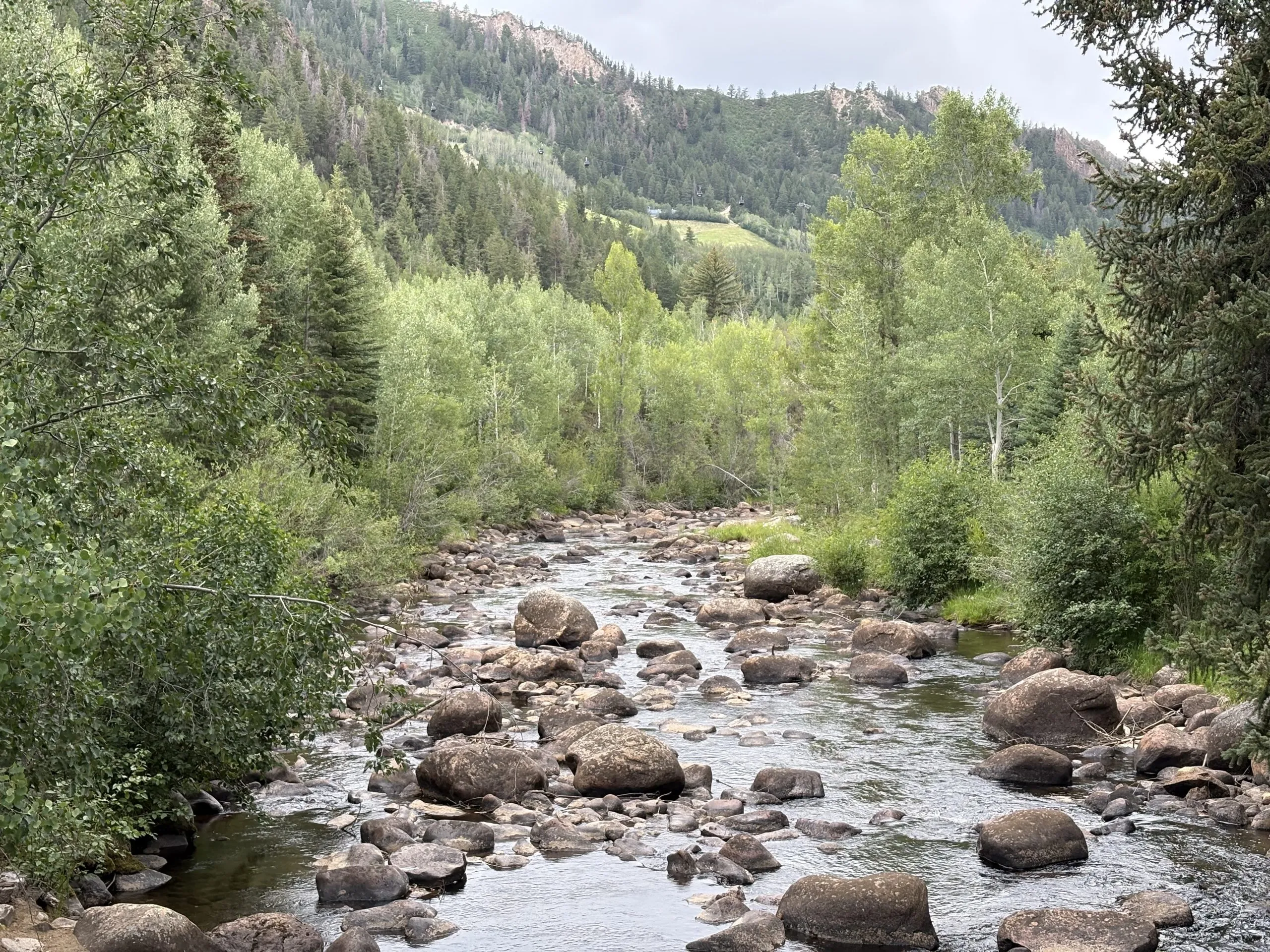

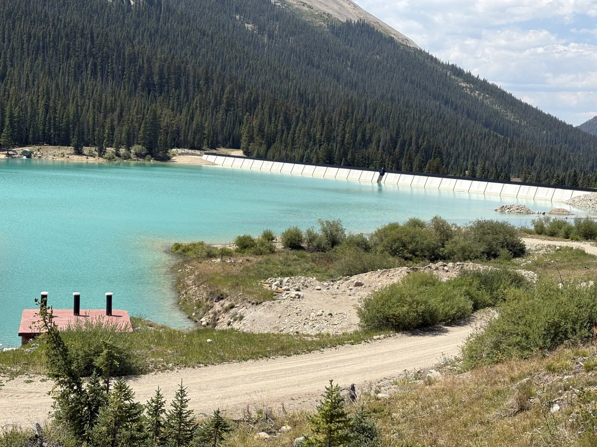


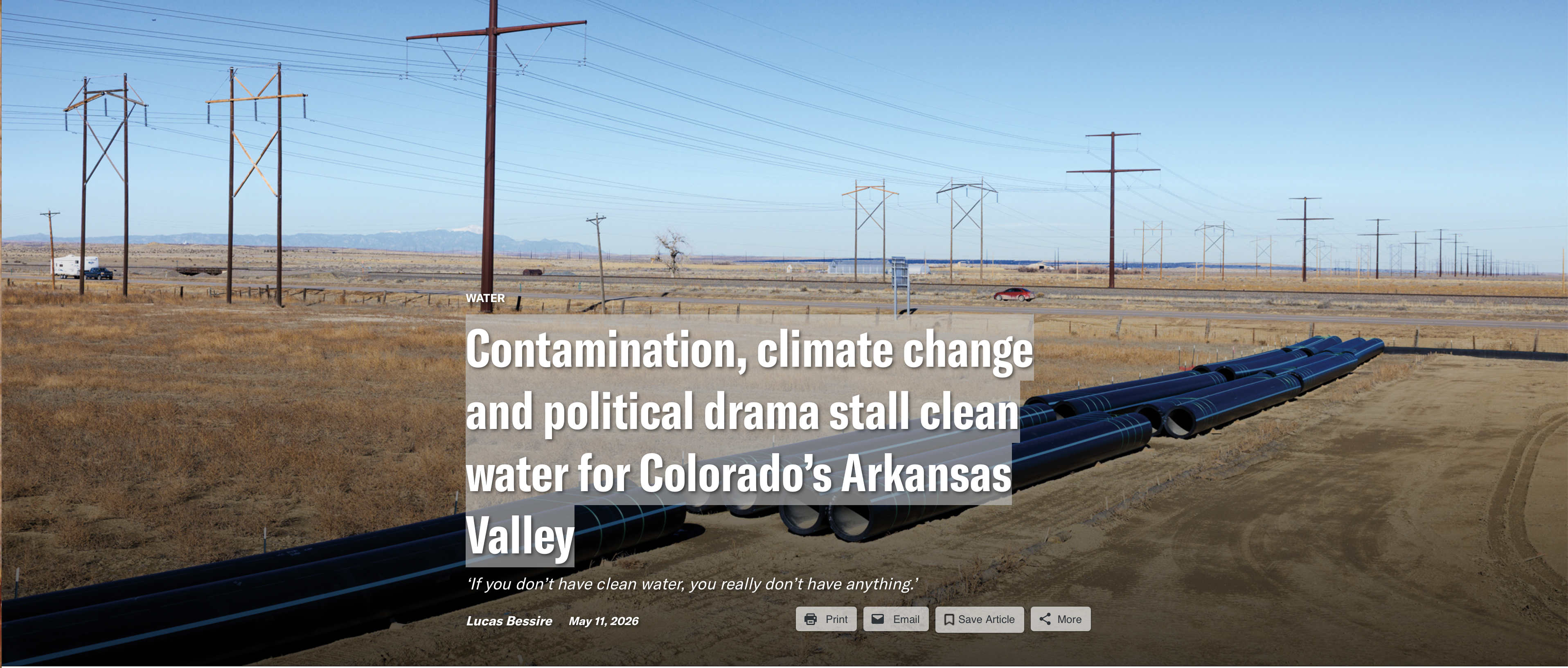


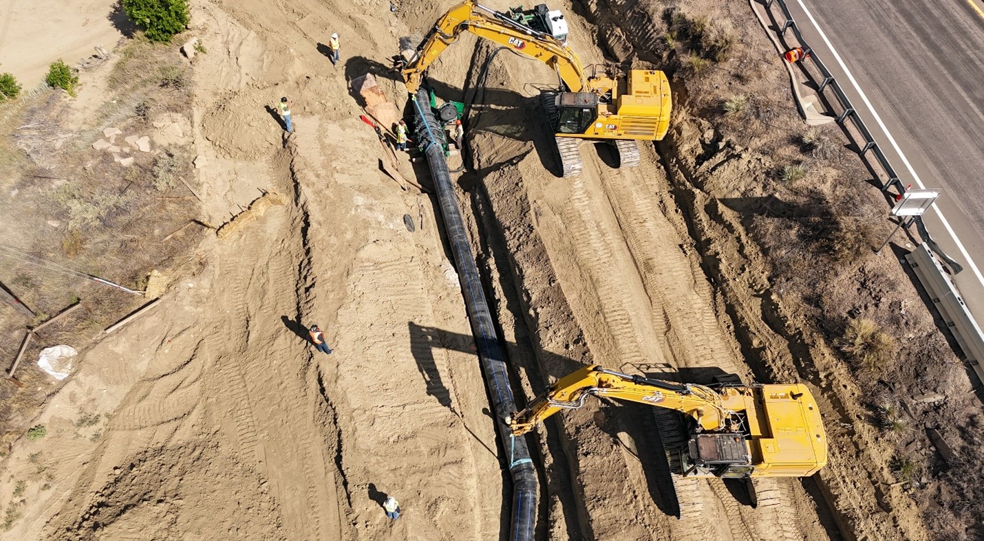
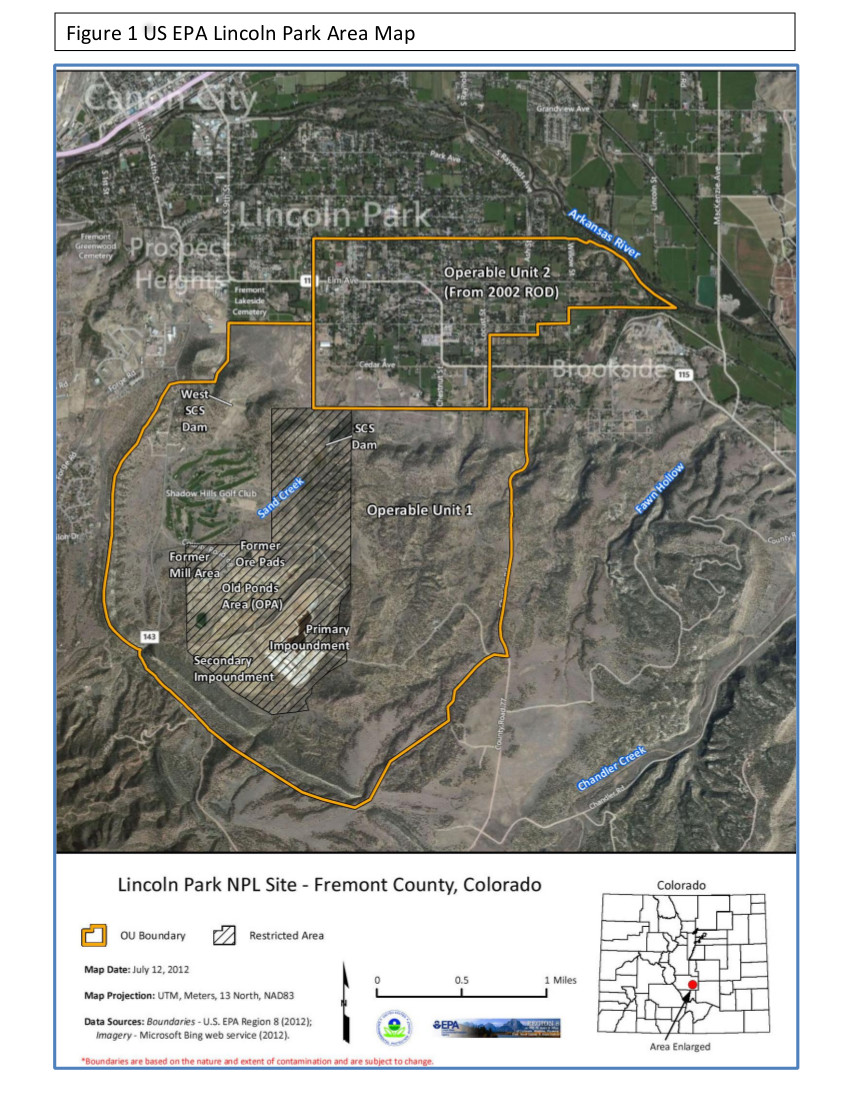
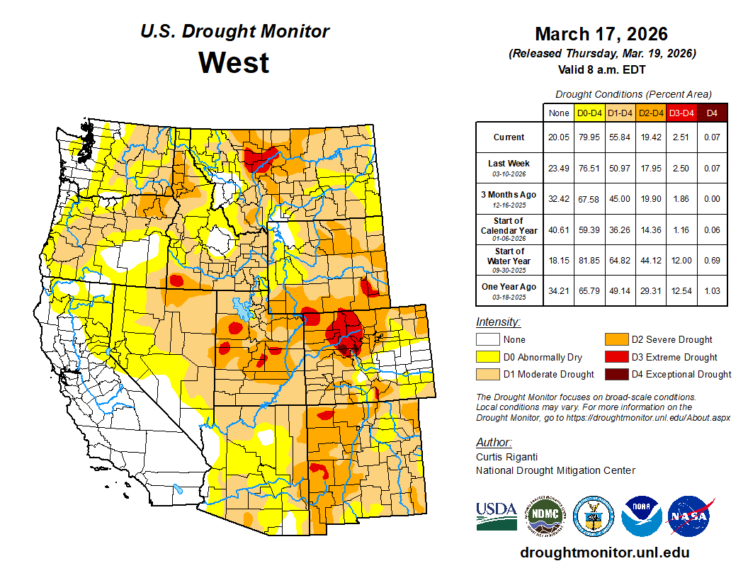
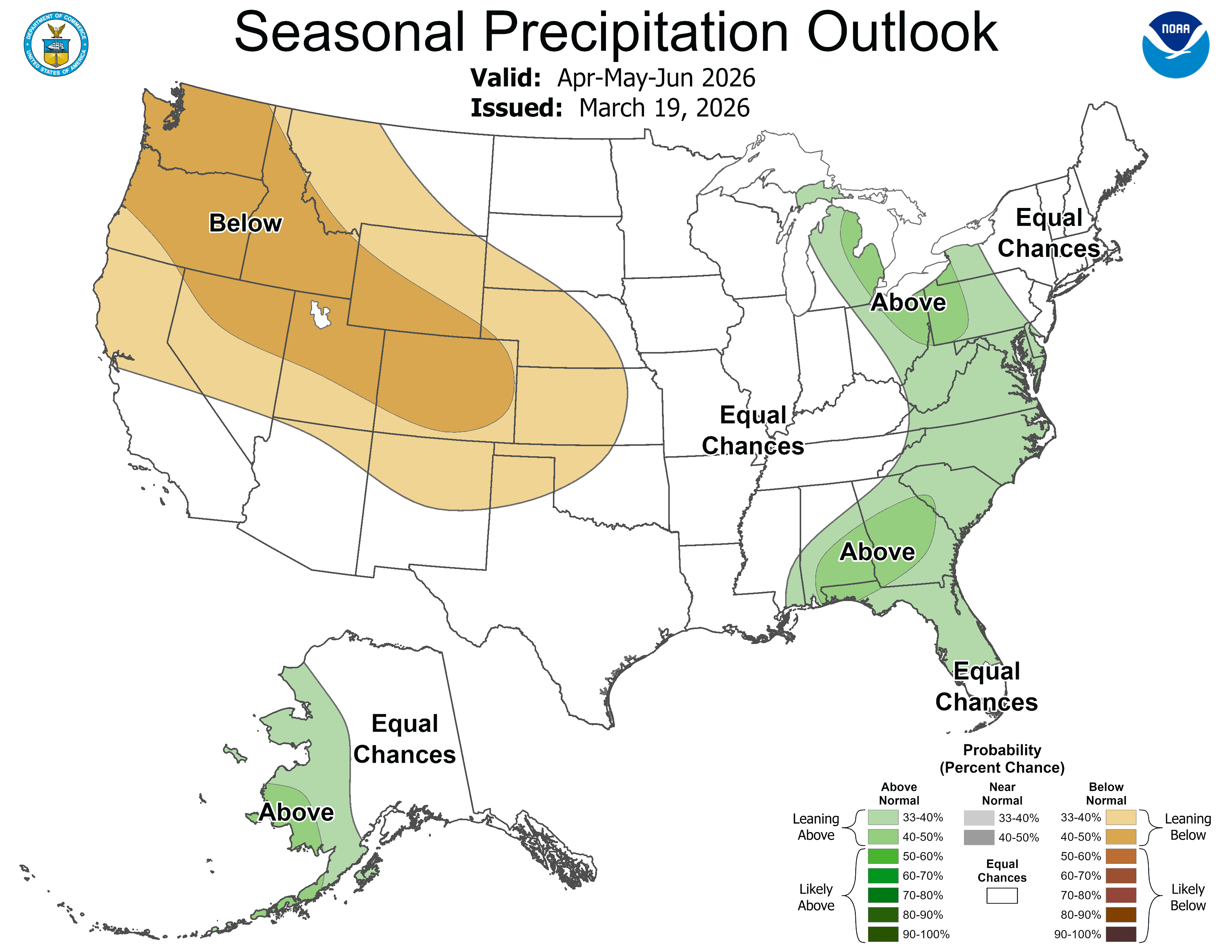


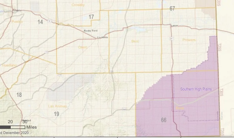

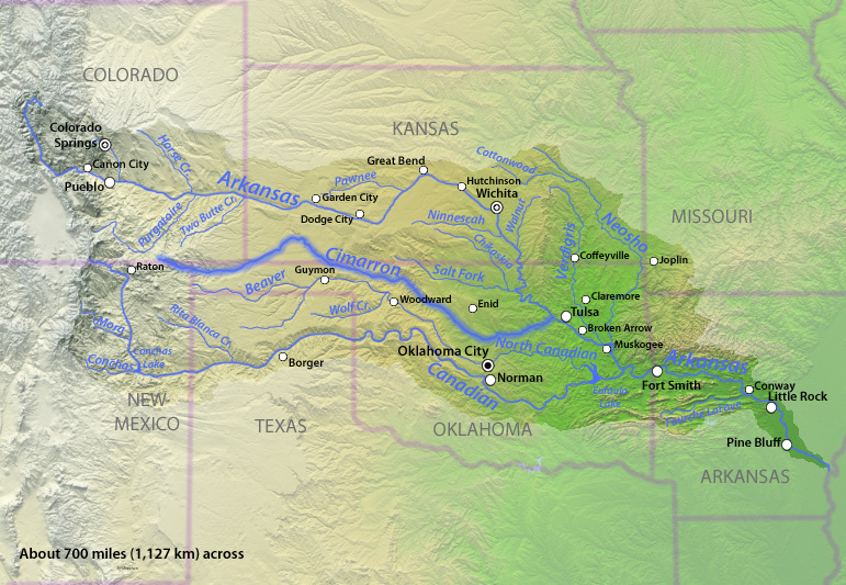
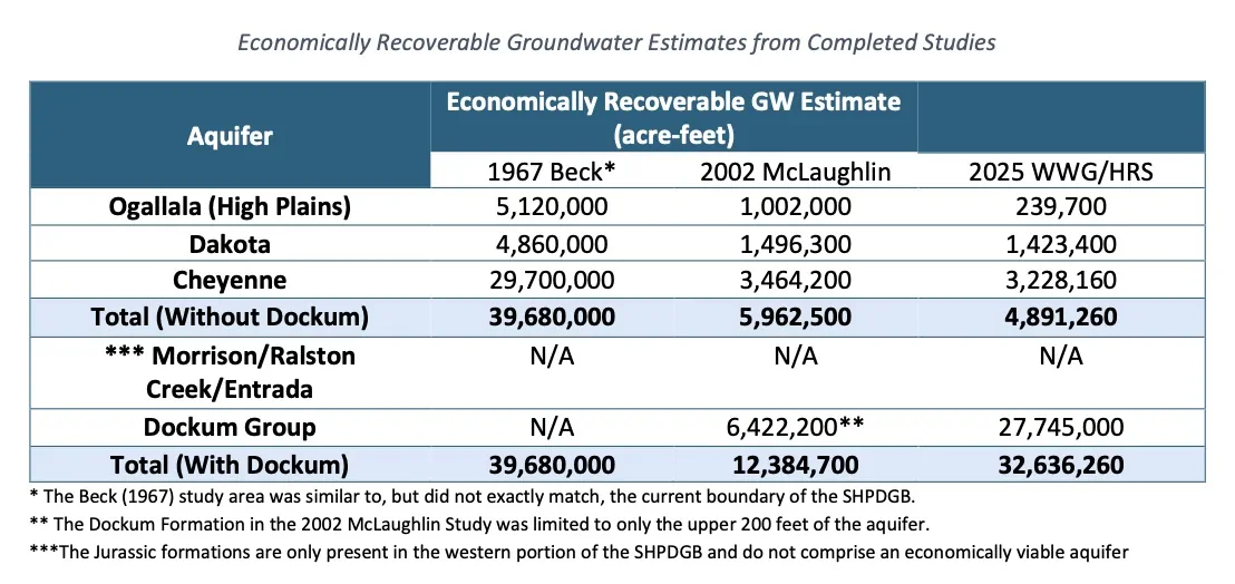
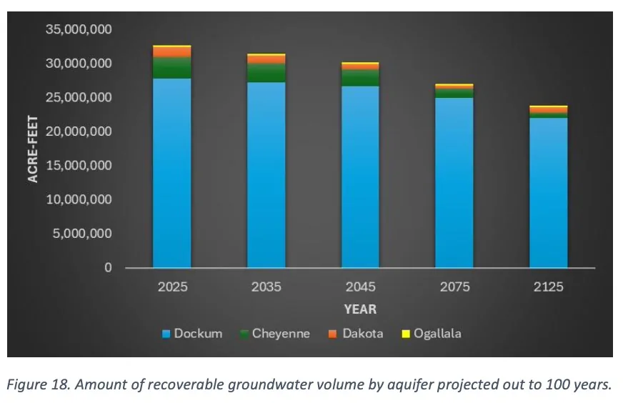
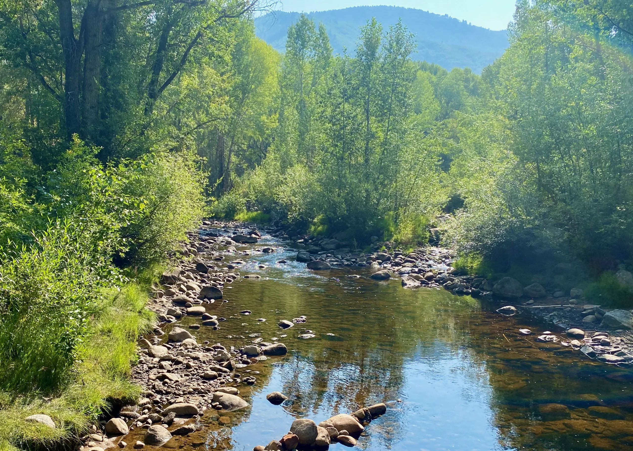


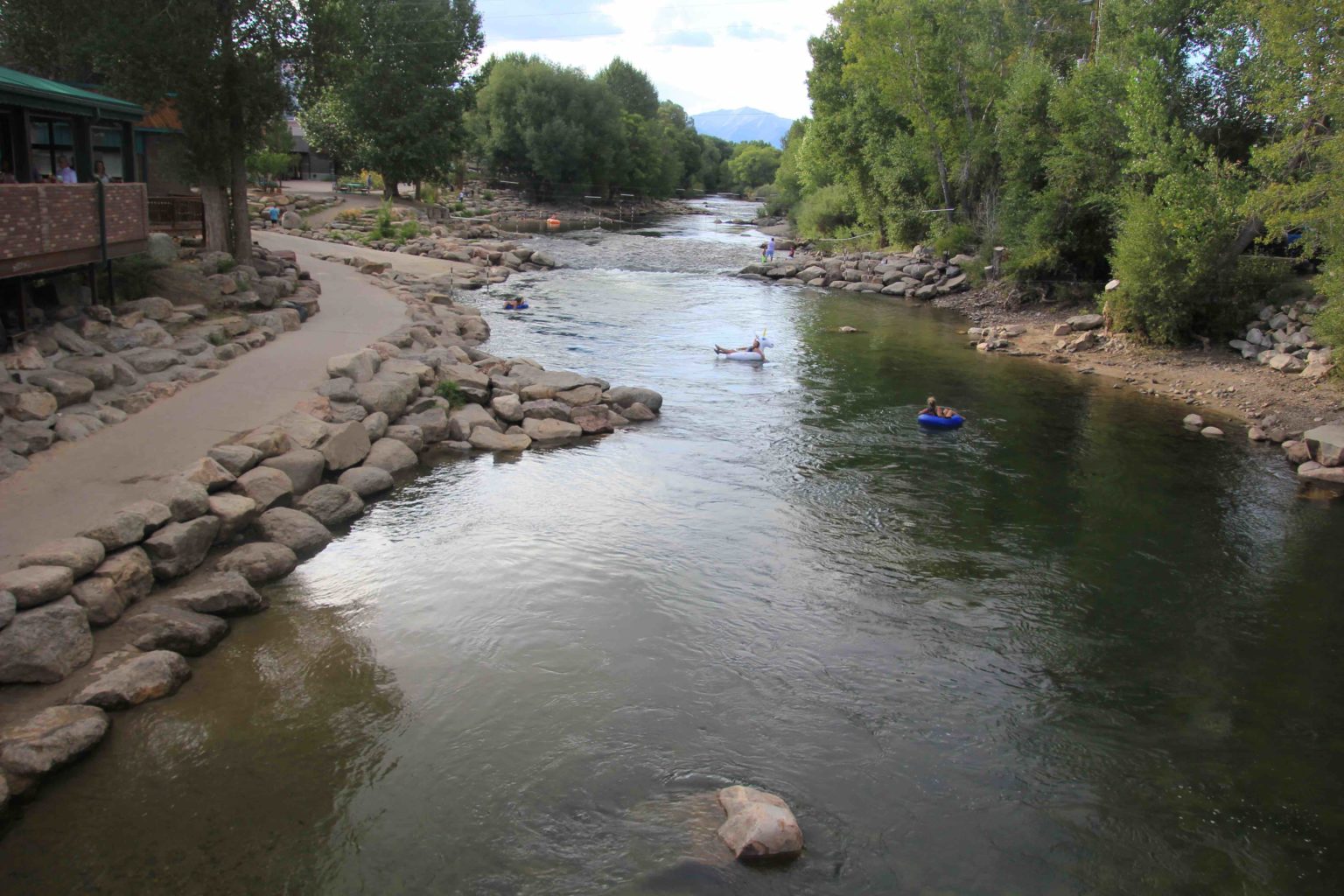
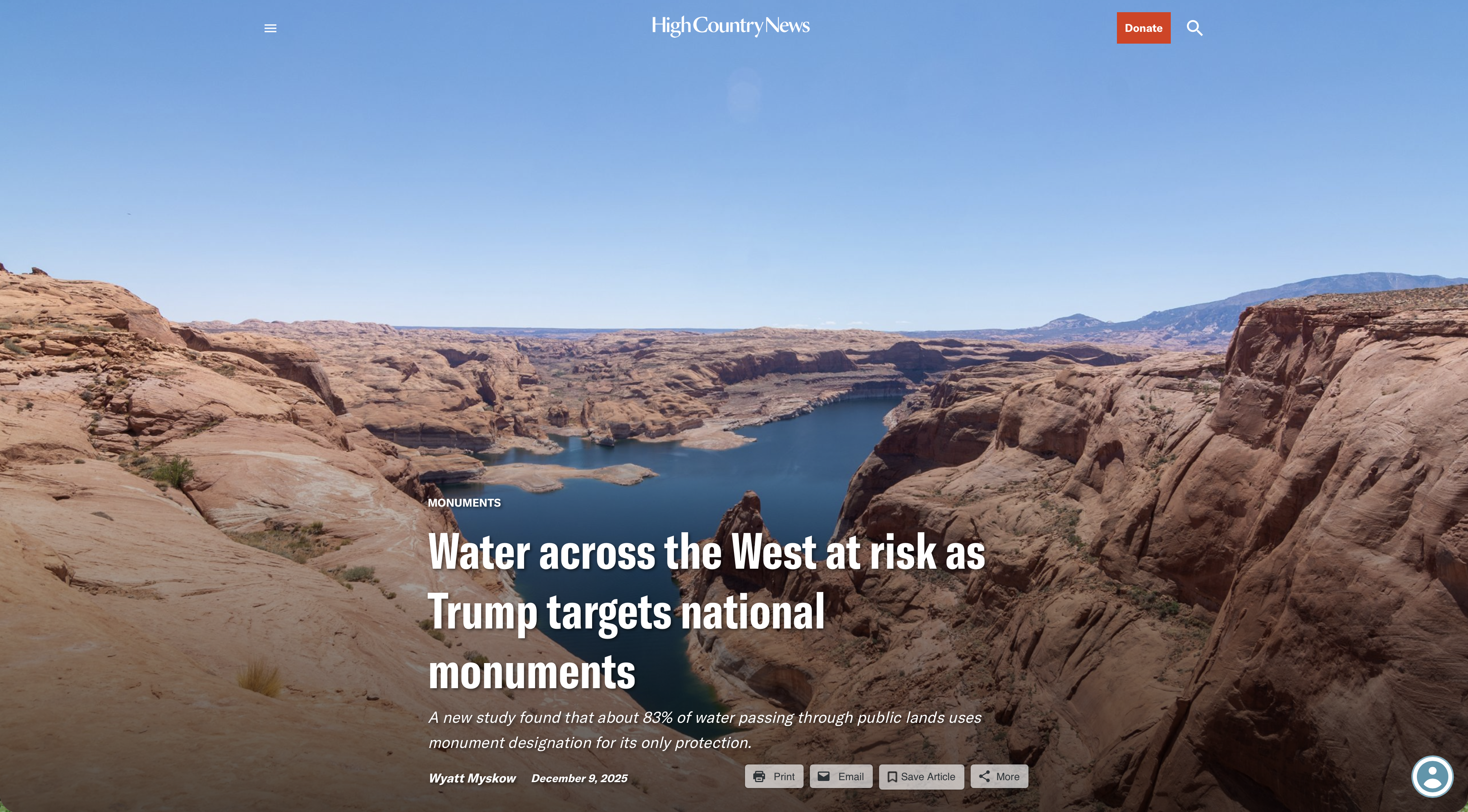
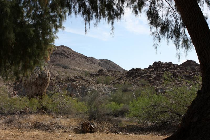

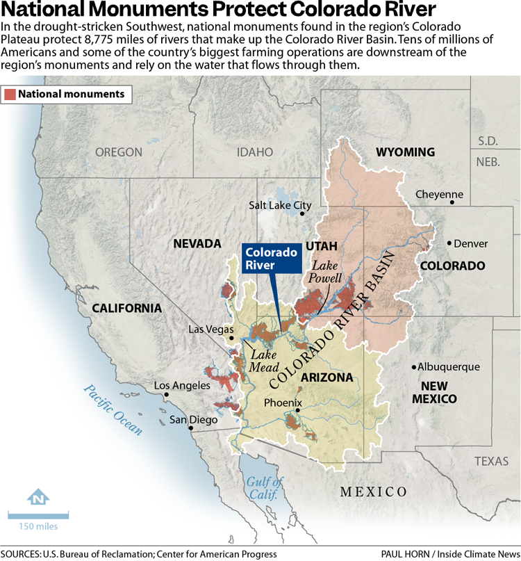


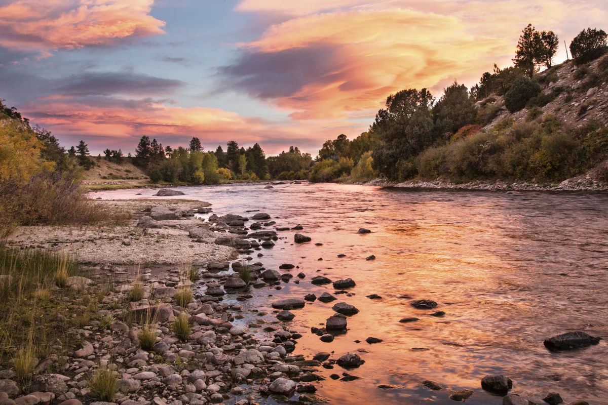
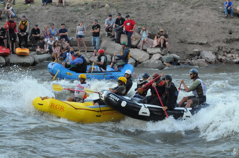
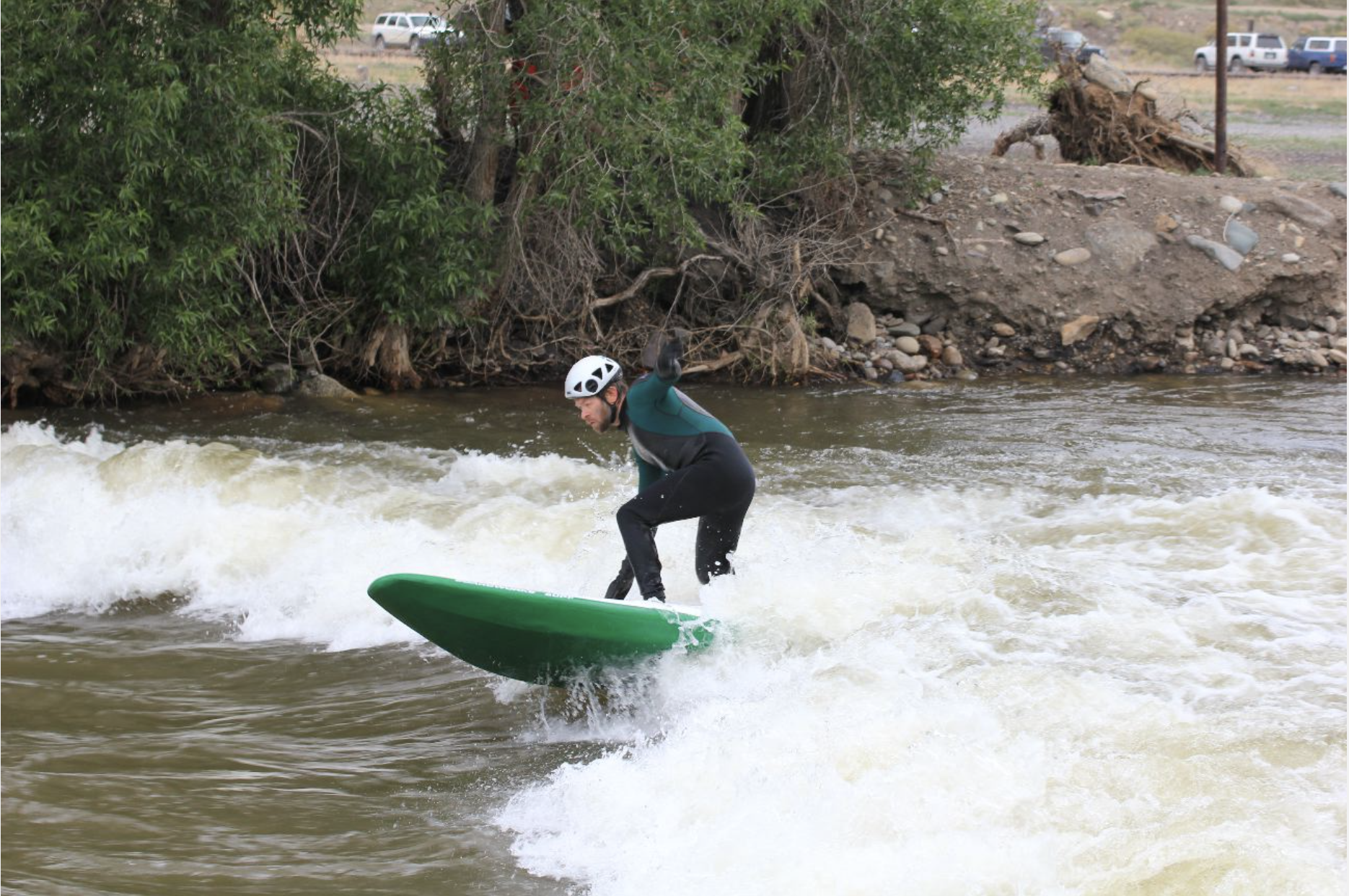


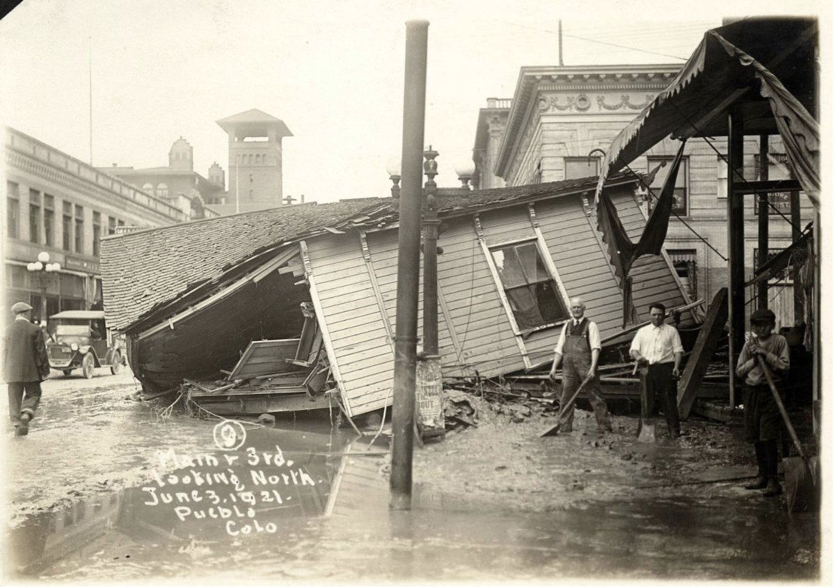
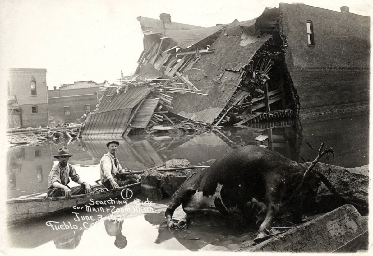

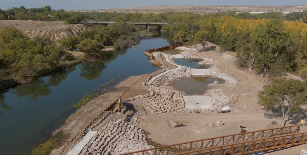


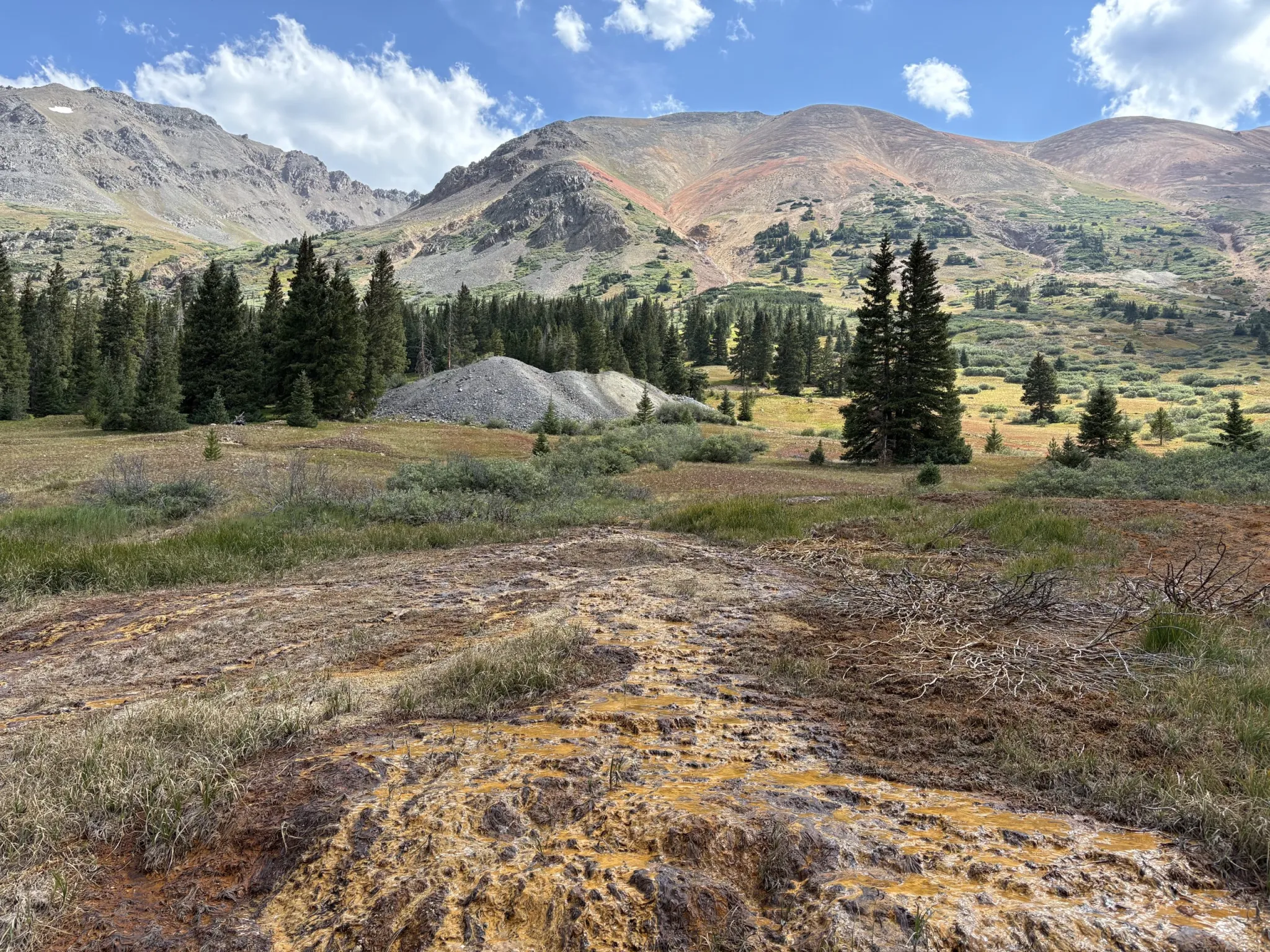

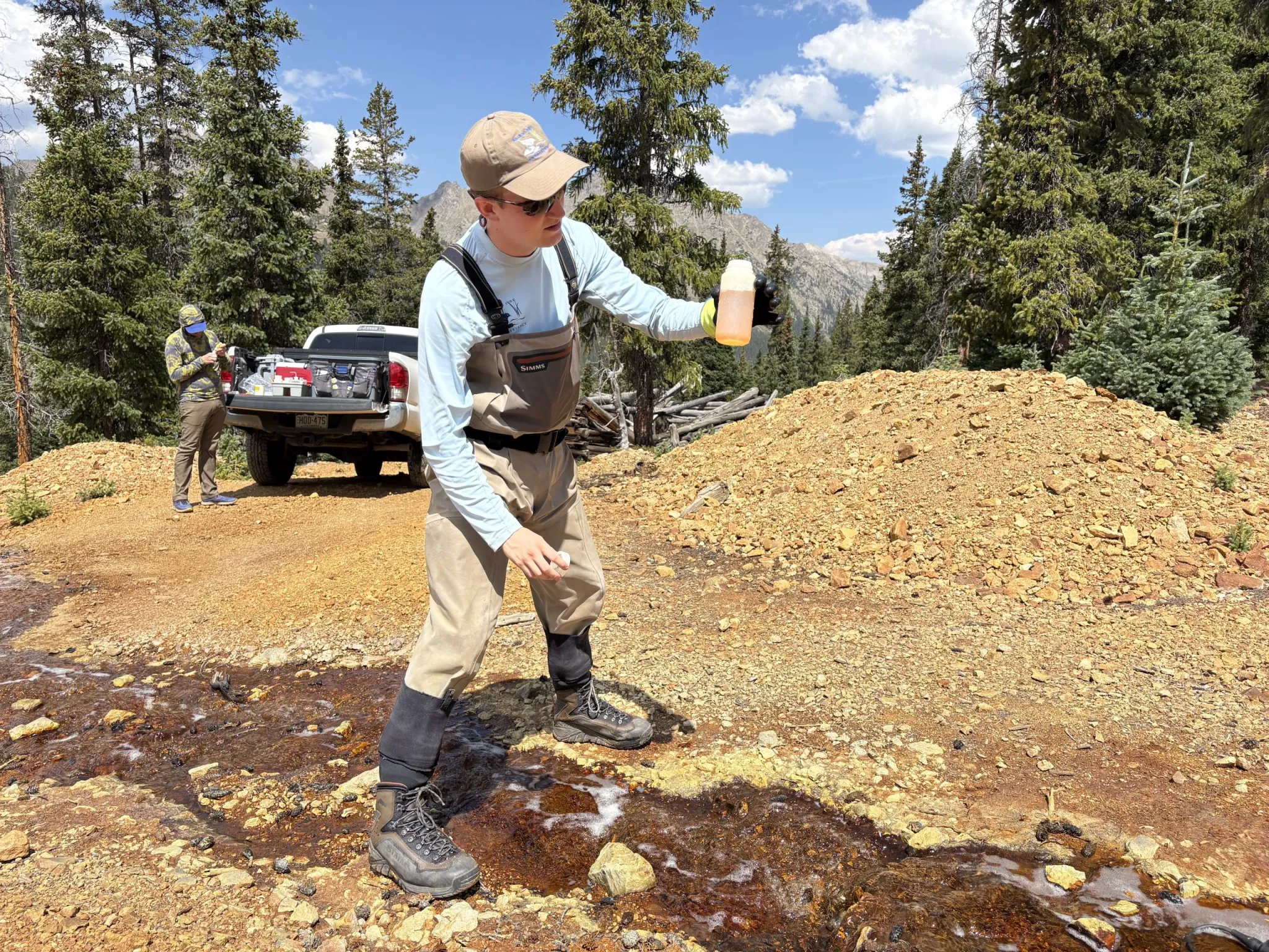


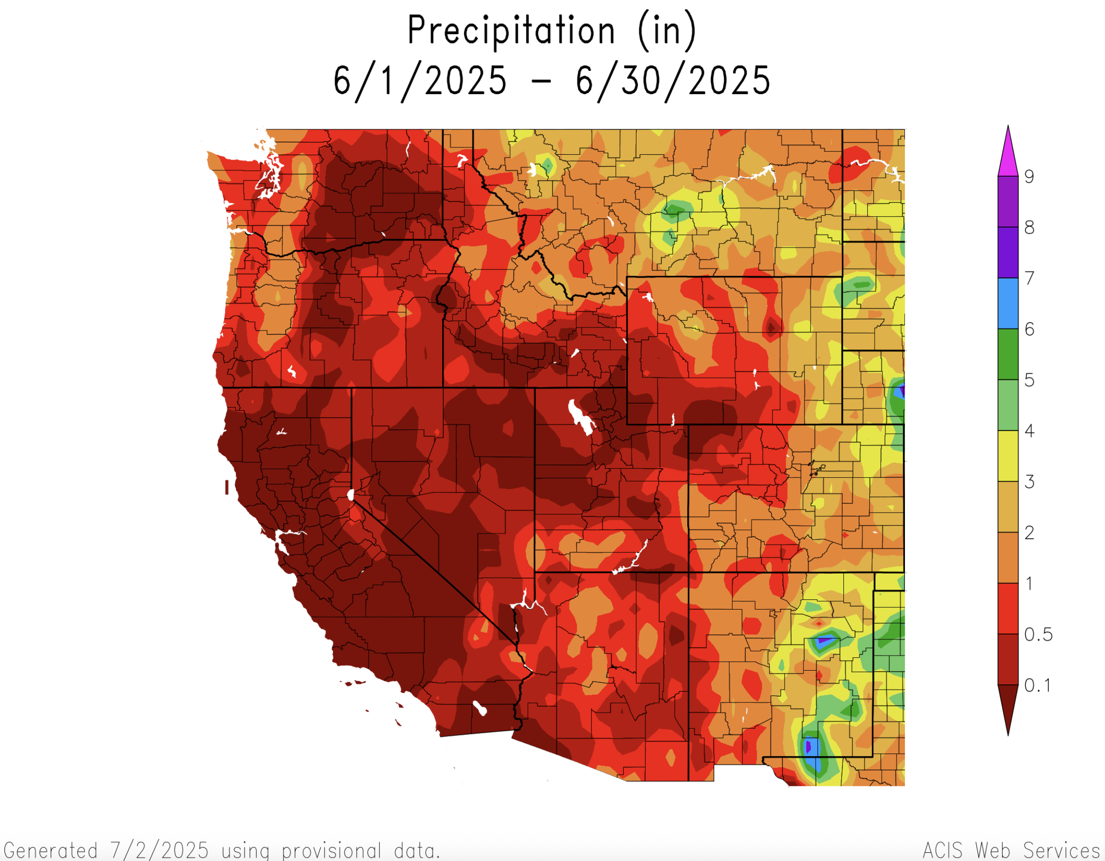
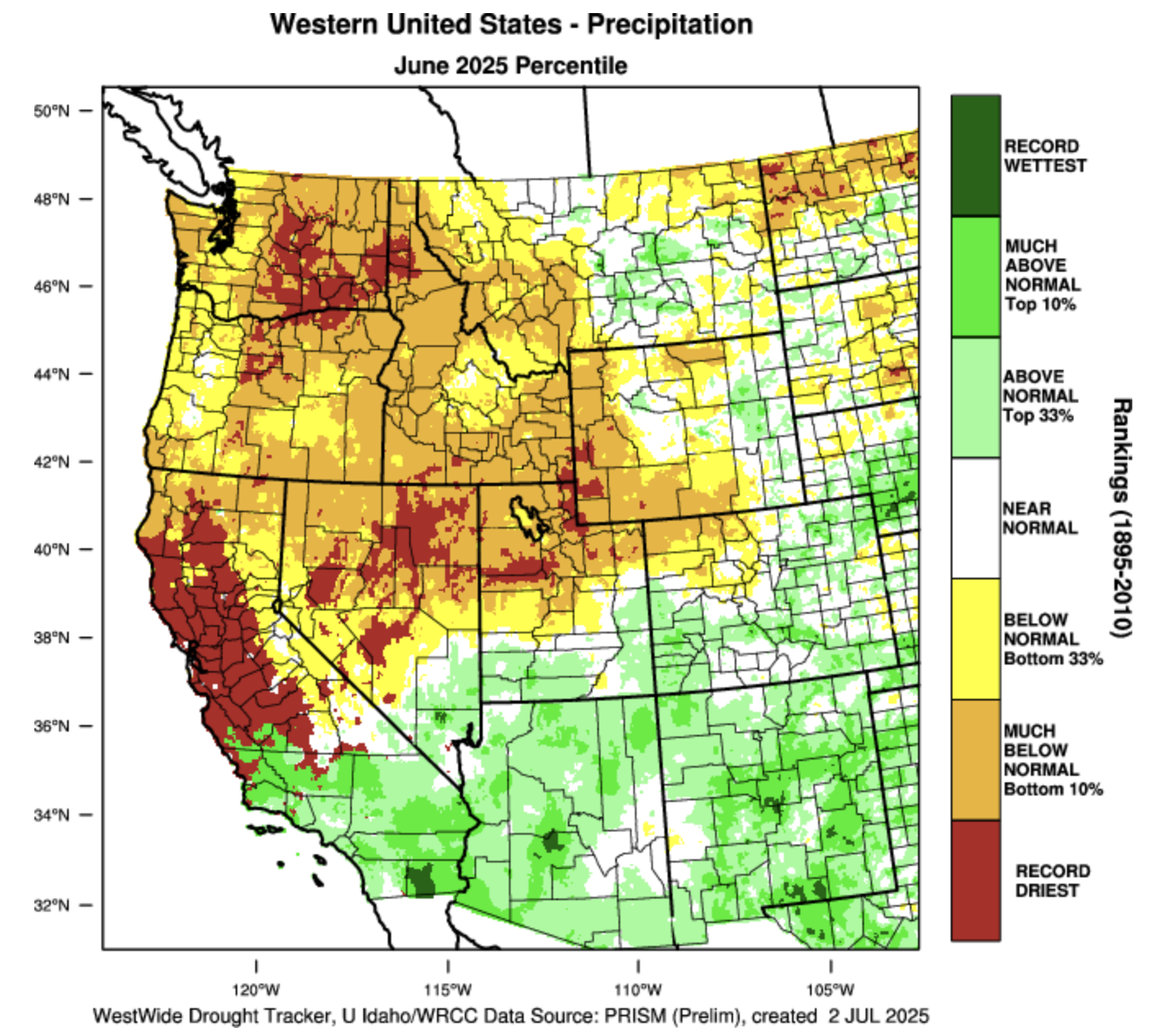
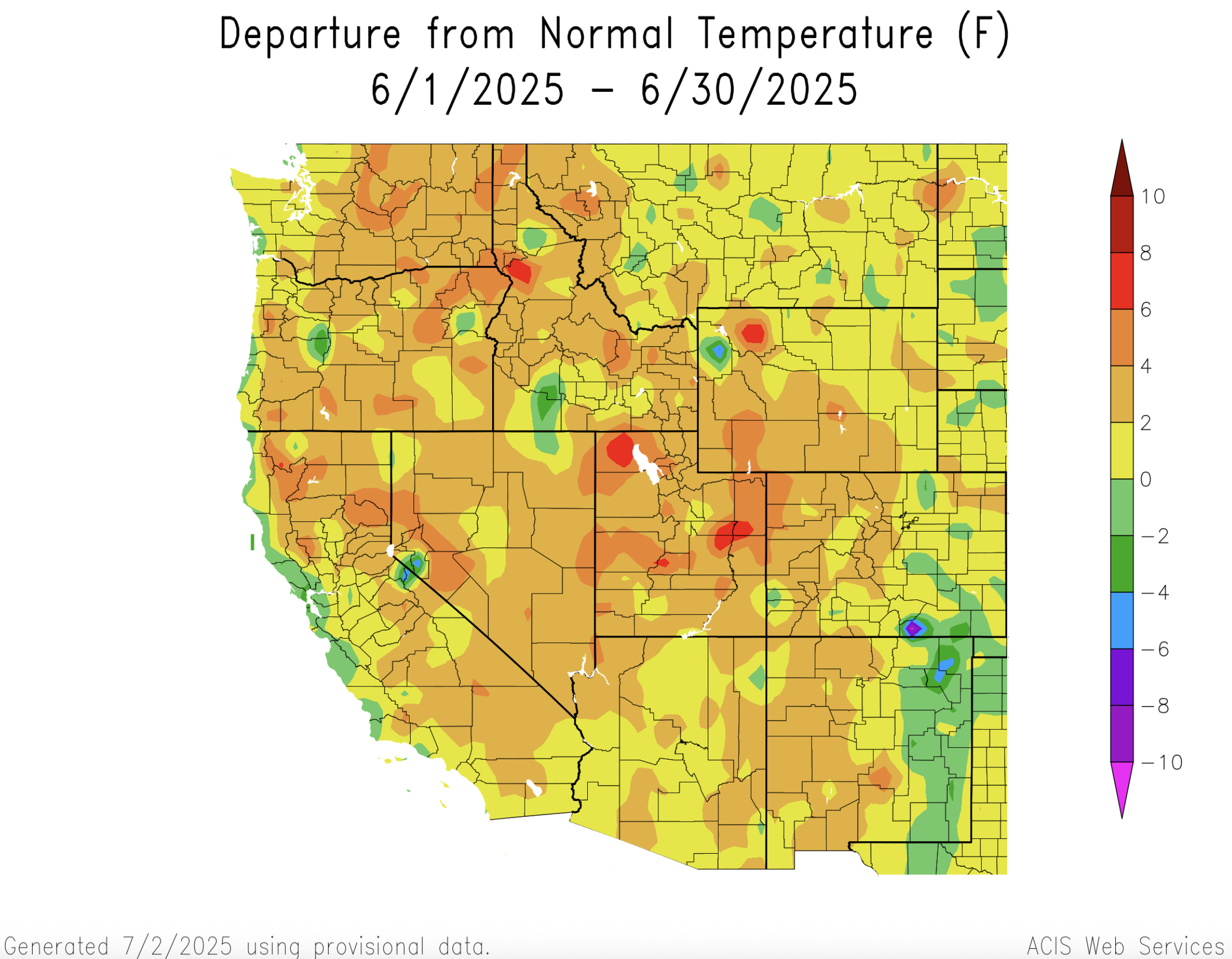
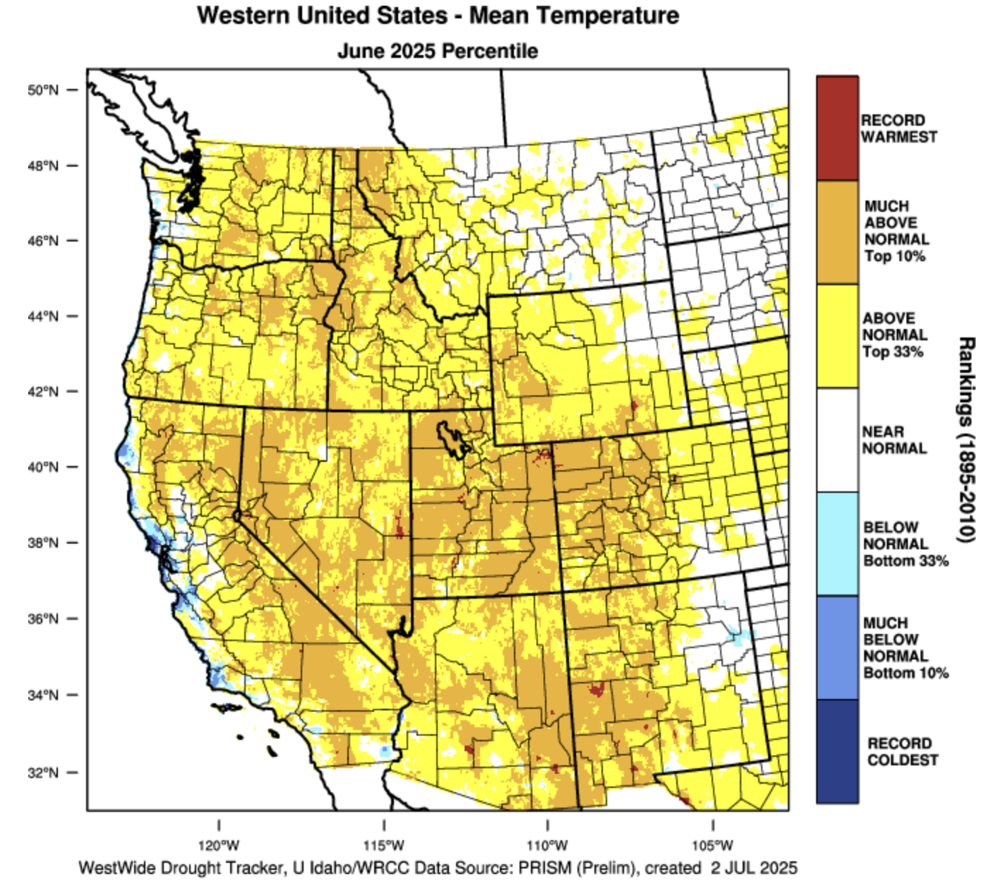
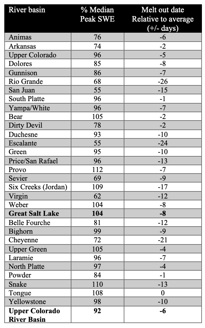
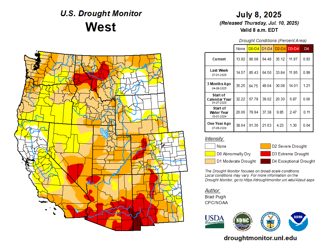
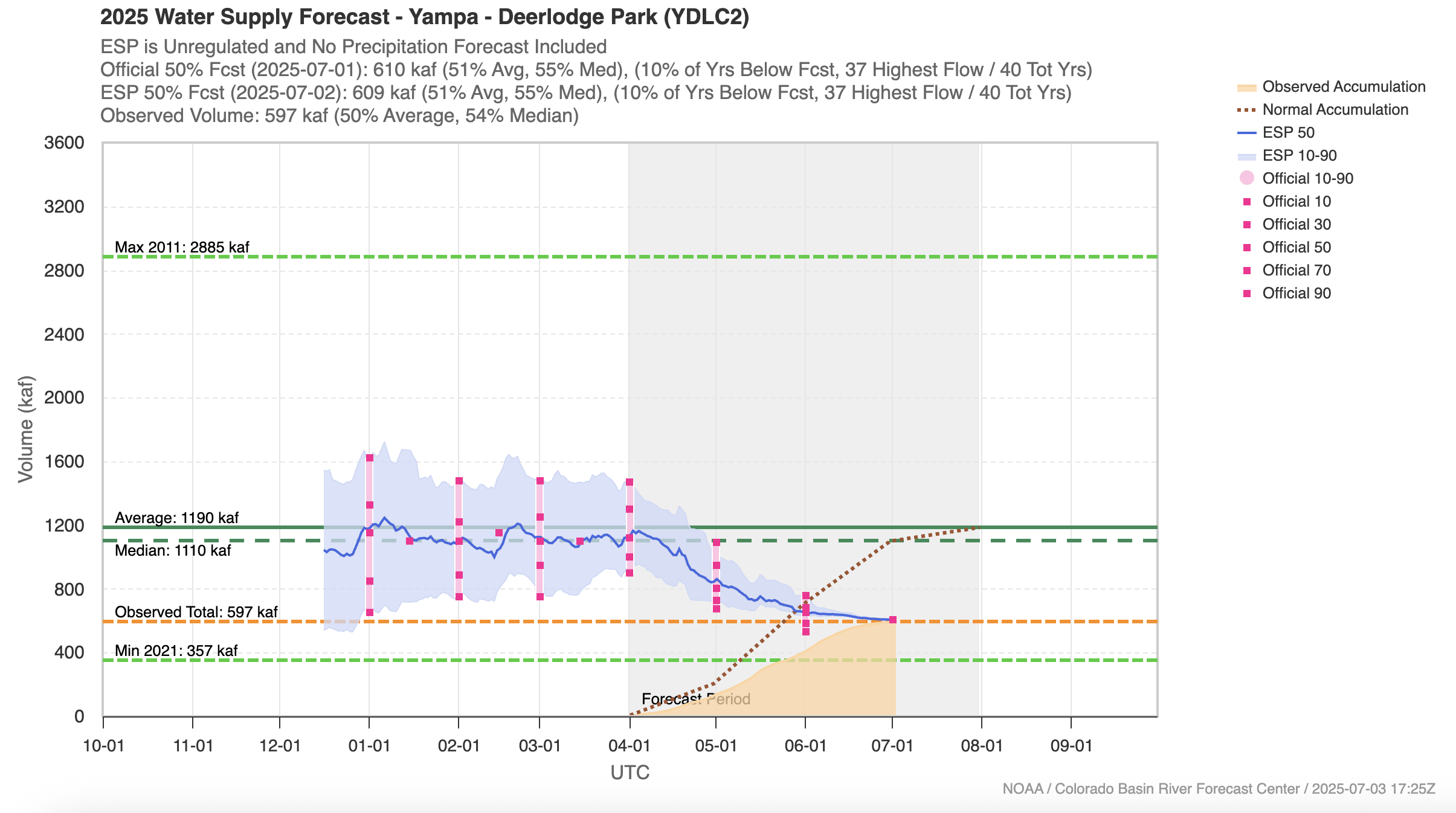


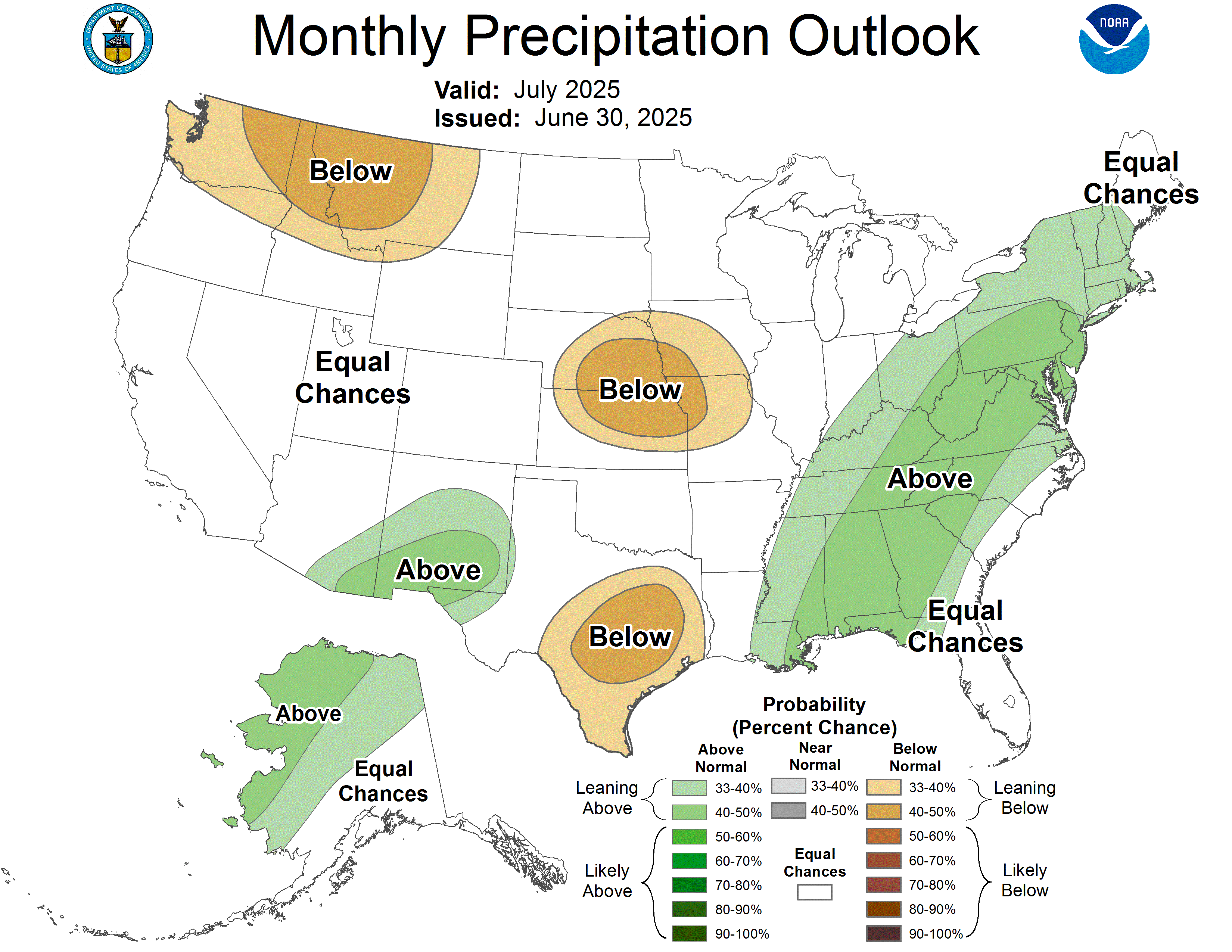
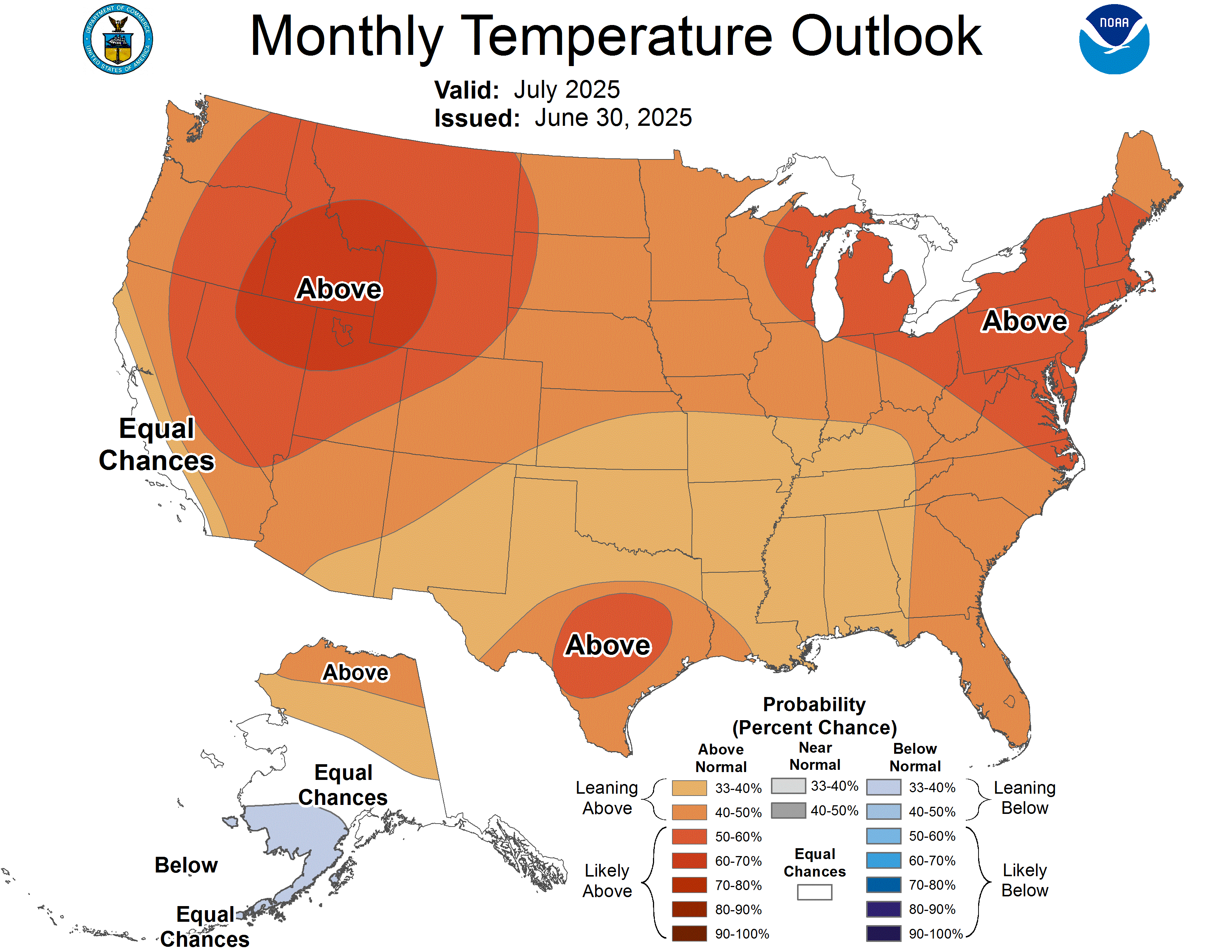

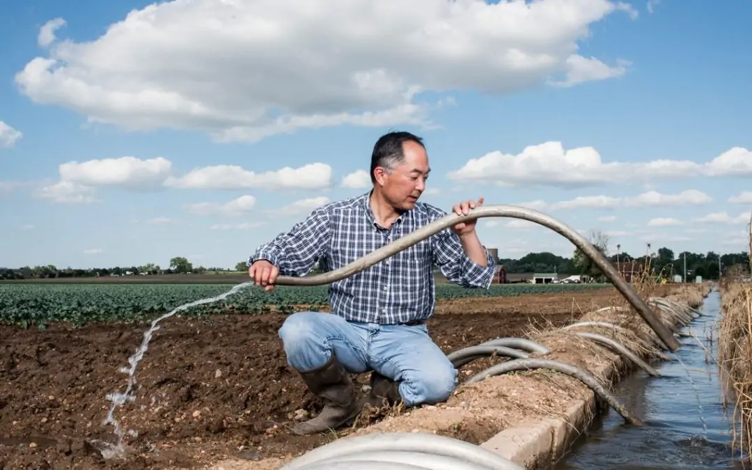


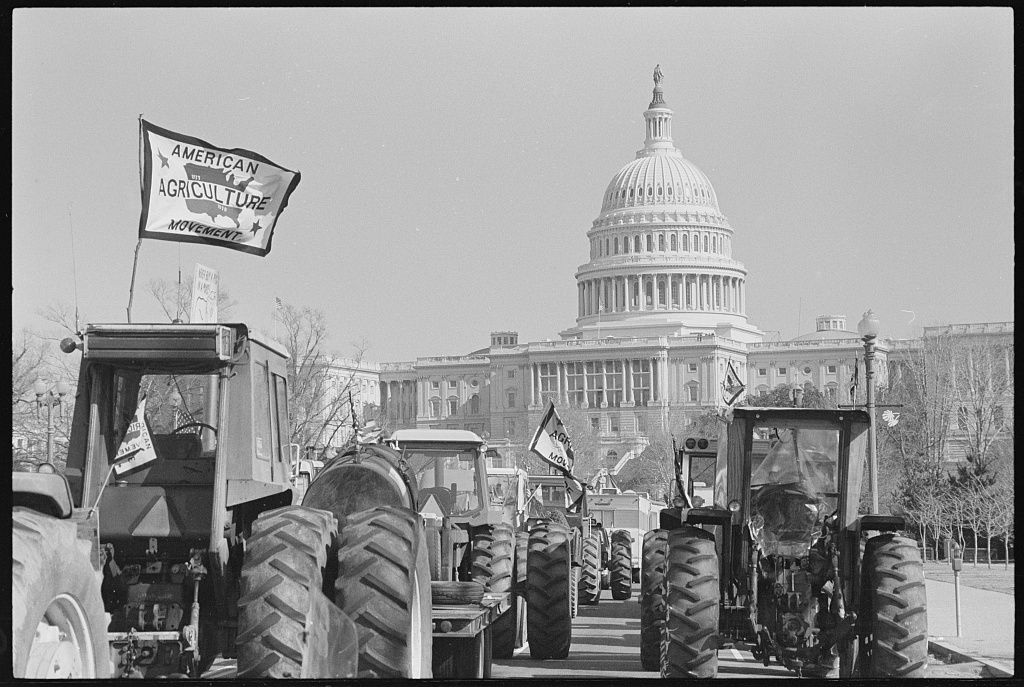


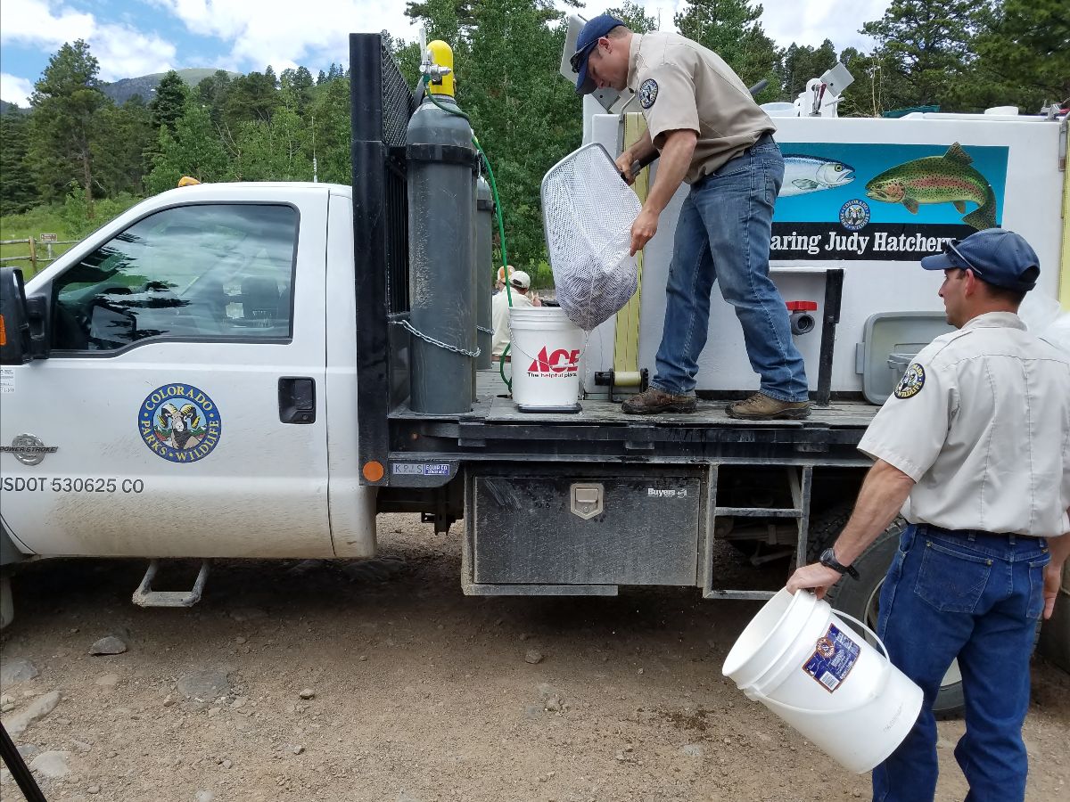
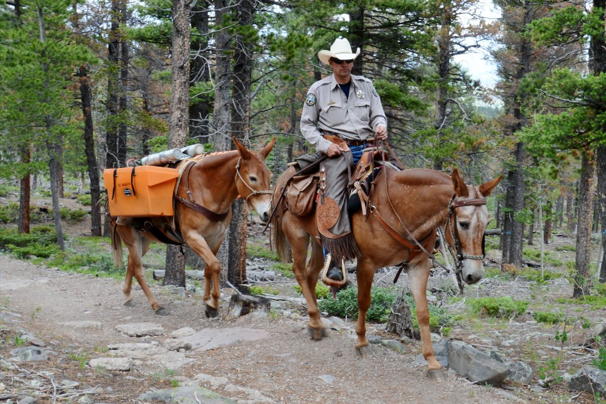
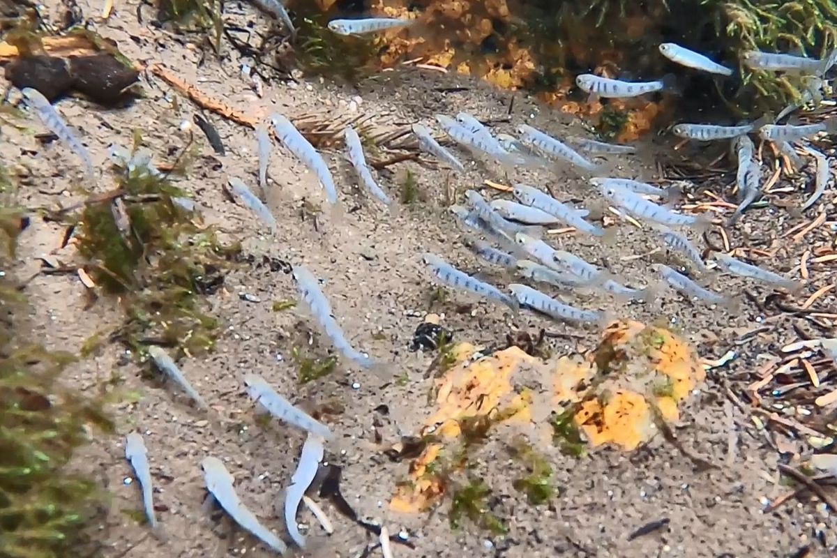


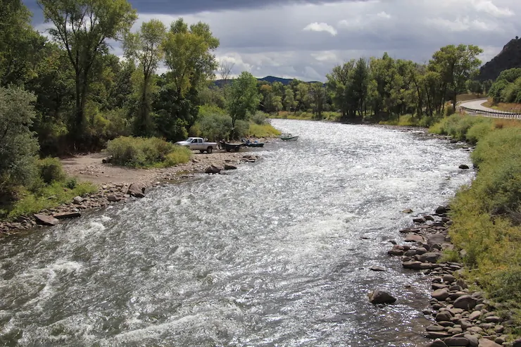


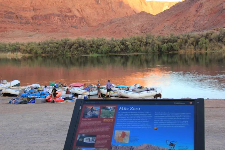


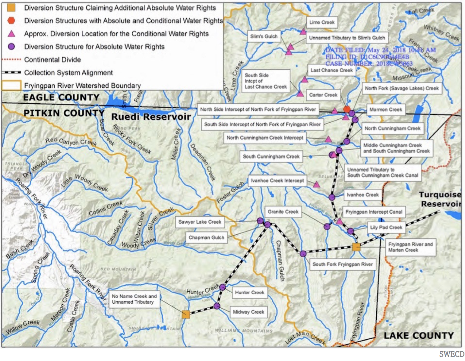
