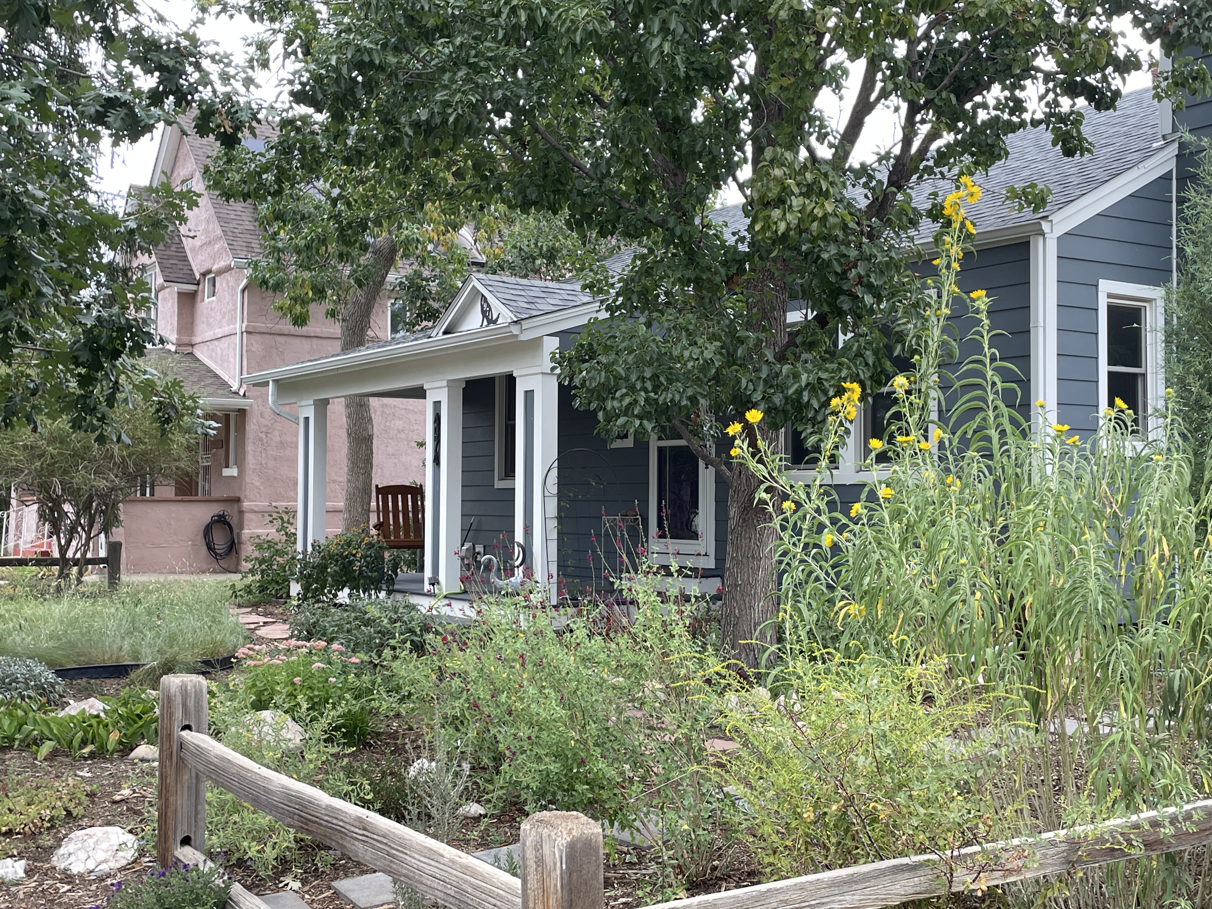
Homes line the foothills outside Colorado Springs on Sept. 11, 2024. The city has doubled down on water conservation to make its recent spike in population growth possible. (Luke Runyon/The Water Desk)
When researcher Brian Richter set out to take a close look at how big cities in the Western U.S. were adapting to water scarcity, he already knew the story’s basic contours.
Previous studies showed the trend clearly for some large utilities. As a megadrought has baked the Southwest since 2000, the region’s biggest cities have reined in their use to keep pace with the declining supply.
But it had been years since someone took a more region-wide look at who was conserving and how much. Richter, a lecturer at the University of Virginia, and president of his own independent research firm, Sustainable Waters, was up to the task.
After gathering data for 28 large and medium-size water utilities dependent on the Colorado River, Richter and his team were able to see the more modern trend lines in sharp detail. The results surprised him. It wasn’t just that cities like Denver, Los Angeles, Tucson and Las Vegas were using less. They were doing it while growing rapidly.
His 2023 study found that collectively the region’s cities had grown by 25% from 2000 to 2020, while their water use dropped by 18%. Per person use rates declined even more sharply, falling by 30%.
“We thought that was nothing short of miraculous, to be honest,” Richter said. “It’s quite a water conservation success story.”
Richter had heard the region’s growth anxieties before. As homes spring up, highways widen and new schools open, conversations about rising populations in the arid West eventually find their way to water. Those new residents mean more green lawns and household faucets, forcing cities to scramble to meet the new demand, or so the thinking goes.
It’s easy to understand why the notion that more people beget more water use jumps to people’s minds, Richter said. All of the on-the-ground impacts of growth are highly visible.
“What you can’t see so easily are the numbers, the water numbers behind that growth,” Richter said. “We felt it was really important to start getting those numbers out there, and to start revealing the fact that it’s not necessarily true any longer, that as a city’s population grows its water use has to increase at the same time.”
Now, as pressure from climate change mounts, the region faces a critical question: Can urban areas keep pace with their past successes in water conservation, or is there a floor to just how much water savings can be wrung from Southwestern cities?
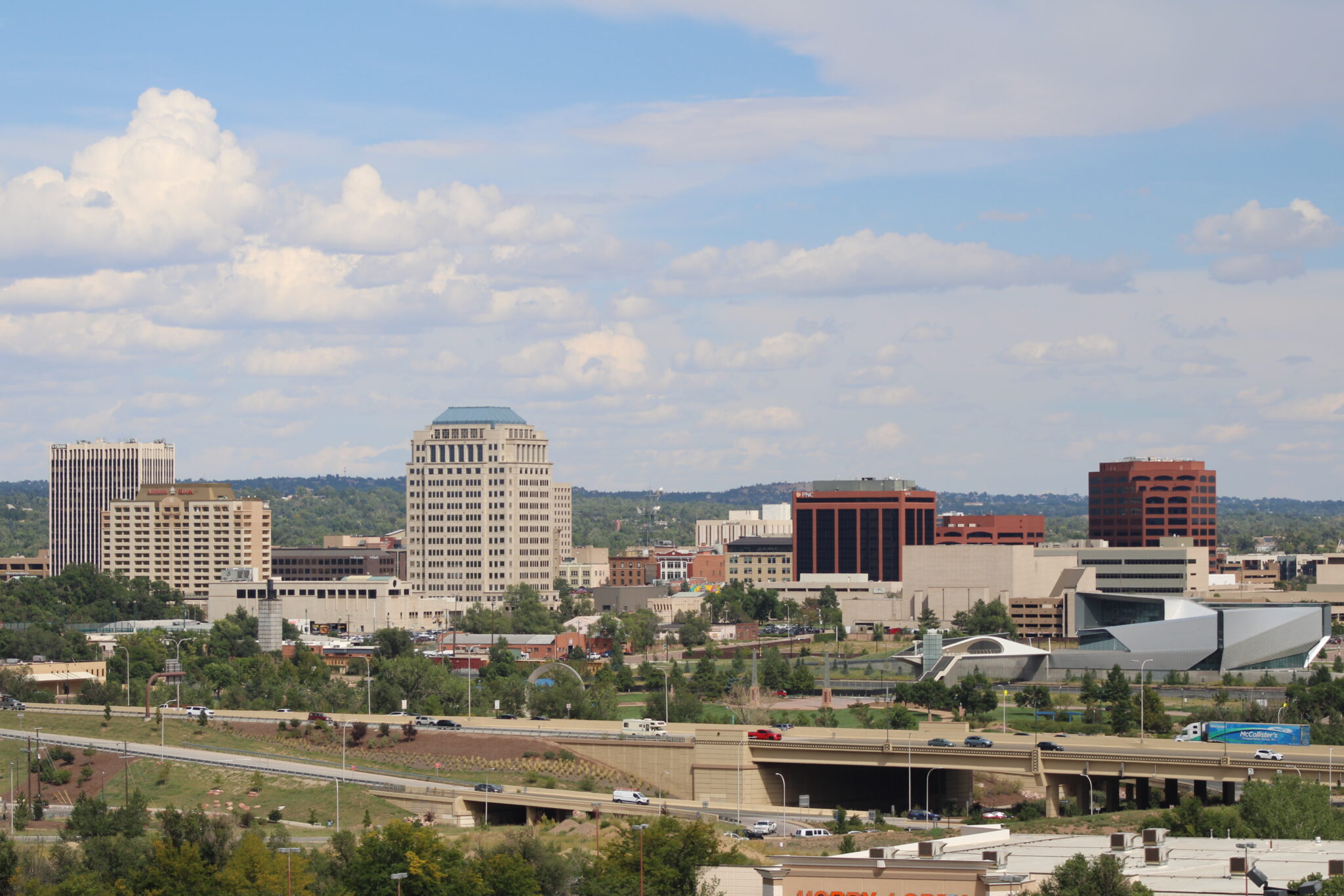
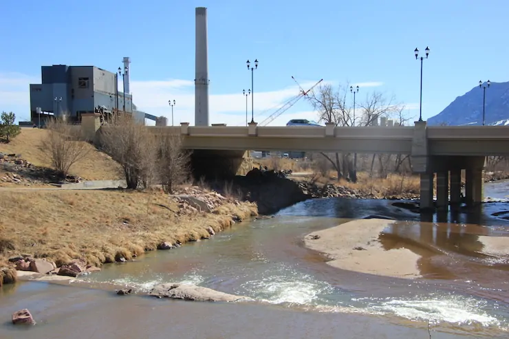
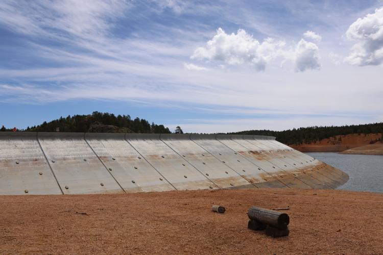
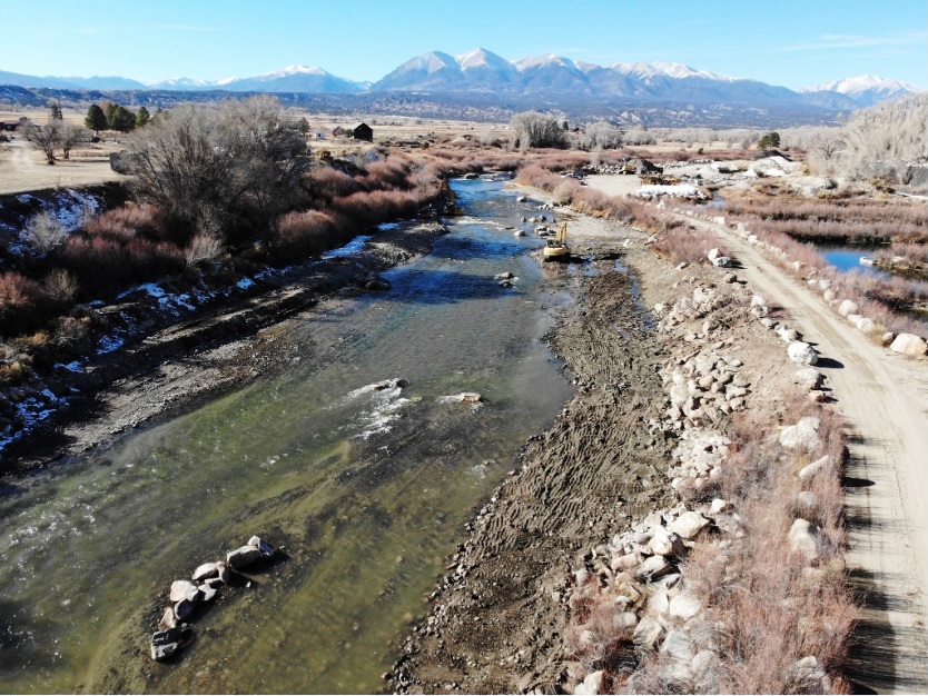
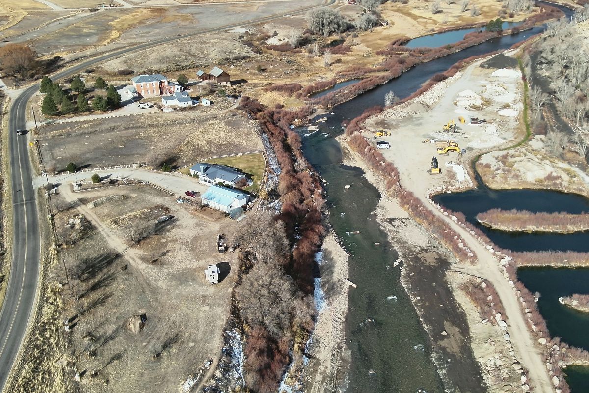
The Colorado Springs skyline rises above Fountain Creek on Sept. 11, 2024. For the past couple decades the city has experienced rapid population growth while ratcheting down its demand for water. (Luke Runyon/The Water Desk)
Using less in Colorado Springs
Until 2002, Colorado Springs was using water like there’s no tomorrow. As the city grew, so did its water demand, hand-in-hand.
“There was a lot of inefficiency out there, a lot of inefficient fixtures, a lot of landscape irrigation, primarily of turf grass,” said Scott Winter, Colorado Springs Utilities water conservation project manager. “A lot of it was, frankly, egregious.”
A punishing drought in 2002 provided a shock to the system. While reservoirs declined, the people in charge of Colorado Springs started to realize that unchecked water use would eventually lead to serious shortages. Mandatory restrictions on use at the city level ran from 2002 to 2005.
“I don’t think people thought of the water system, the water supply, as being constrained in any way until we hit 2002 and then our perspective changed on the scarcity of water and how reliable our supply was,” Winter said.
Conservation is now seen as a reliable way to live within their means, he said.
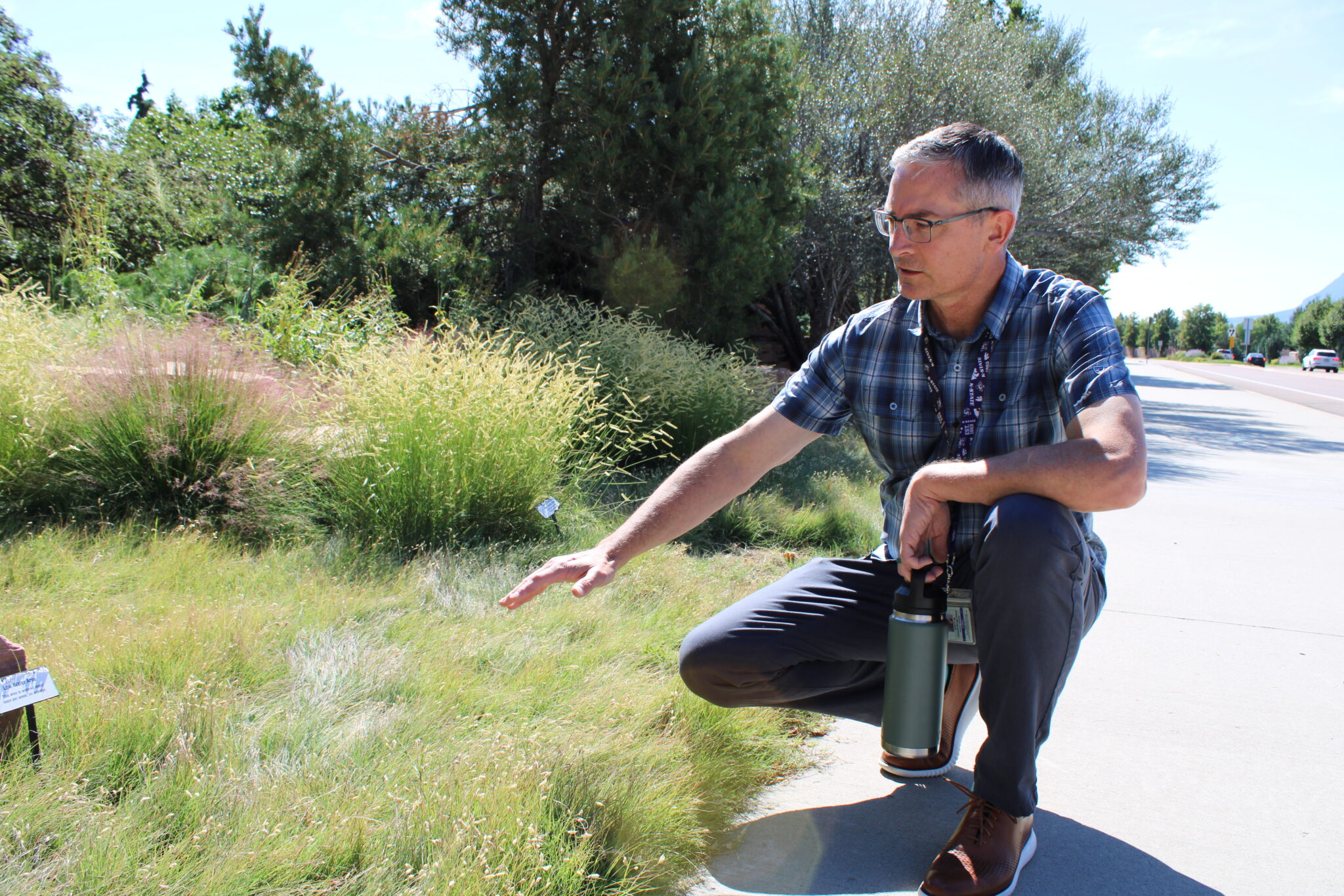
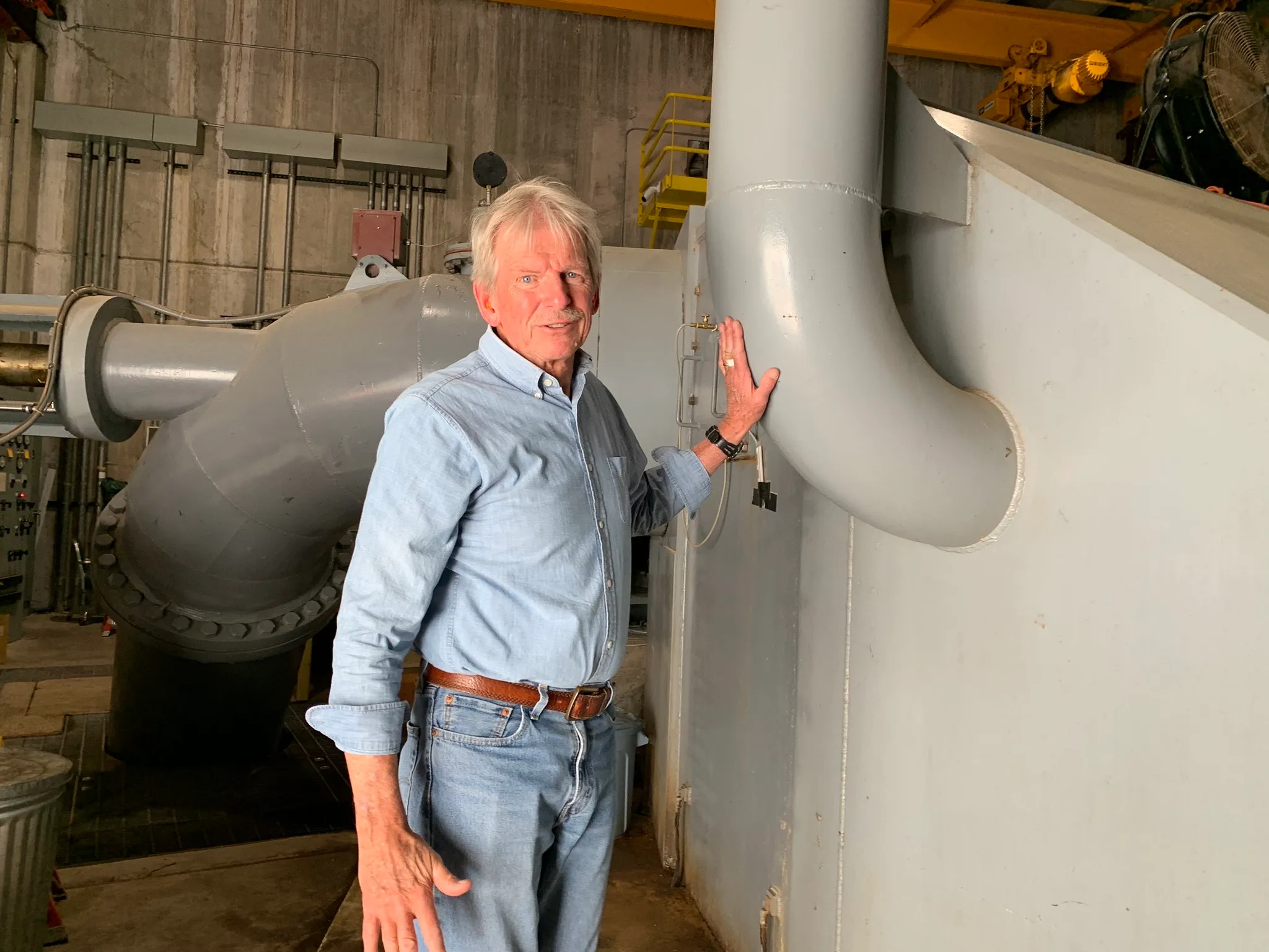
Scott Winter, Colorado Springs Utilities water conservation project manager, points out a turf grass conversion project on Sept. 11, 2024. The utility offers incentives to encourage homeowners and commercial businesses to swap lawns for native grasses. (Luke Runyon/The Water Desk)
Colorado Springs has taken a gradual approach. First came the rate changes. Residents who irrigated more paid more per gallon. Then came the incentives to swap out indoor plumbing fixtures, such as replacing a toilet that uses 5 gallons per flush with a new model that uses less than 1.
The city has also begun to embrace the loss of its lawns. It ramped up its lawn replacement program, in which thirsty yards are replaced with native grasses, like blue grama or buffalo grass, which use 60%-80% less water. The utility offers 50 cents per square foot of lawn converted.
Since Colorado Springs started those conversions in 2013, the city has swapped in native grass on about 3.1 million square feet, or about 72 acres, mostly on commercial properties like shopping centers, churches and business parks. In 2020 a permanent shift to only allow for three days per week of outside watering on existing grass went into effect as well.
Blue grama grows alongside a Colorado Springs parkway on Sept. 11, 2024. Concerns over dwindling water supplies have sped up the city’s conversions of turf grass to blue grama and other native species. (Luke Runyon/The Water Desk)
All of the focus on conservation is paying off, Winter said. From 2000 to 2023, Colorado Springs has grown by about 40%, while also recording a 39% reduction in average per capita water use and about a 25% drop in total water deliveries. The city’s water use is now about equal to what it was in the late 1980s, despite the rapid growth, he said.
Mandatory conservation measures have started taking hold in some parts of the Colorado River Basin, like a nonfunctional turf ban in Las Vegas, for example. But Winter said the cultural and political contours of Colorado Springs mean water managers have to get creative, relying more on voluntary incentives than strict mandates that could rile its conservative voter base.
When the city decided to overhaul its building code a few years ago, the process brought up the usual tensions over growth. One code change ruffled feathers. A restriction on new developments limited turf to 25% of the total landscape.
“Individual freedom is a core value here,” said Nancy Henjum, a Colorado Springs city council member. Henjum summarized the early complaints of some fellow council members: “What do you mean I wouldn’t be able to have Kentucky bluegrass in my whole yard?”
But after lengthy discussions, plus field trips to the infrastructure that brings Colorado River basin water over the mountains to Colorado Springs, lightbulbs went off for the city council members about the scarce nature of their supply, she said. As of June 2023, the turf restriction is now officially part of the city’s landscape code.
“It was ultimately fascinating to watch people who are policymakers kind of push back initially, and then little by little over time recognize this is the right thing to do,” Henjum said.
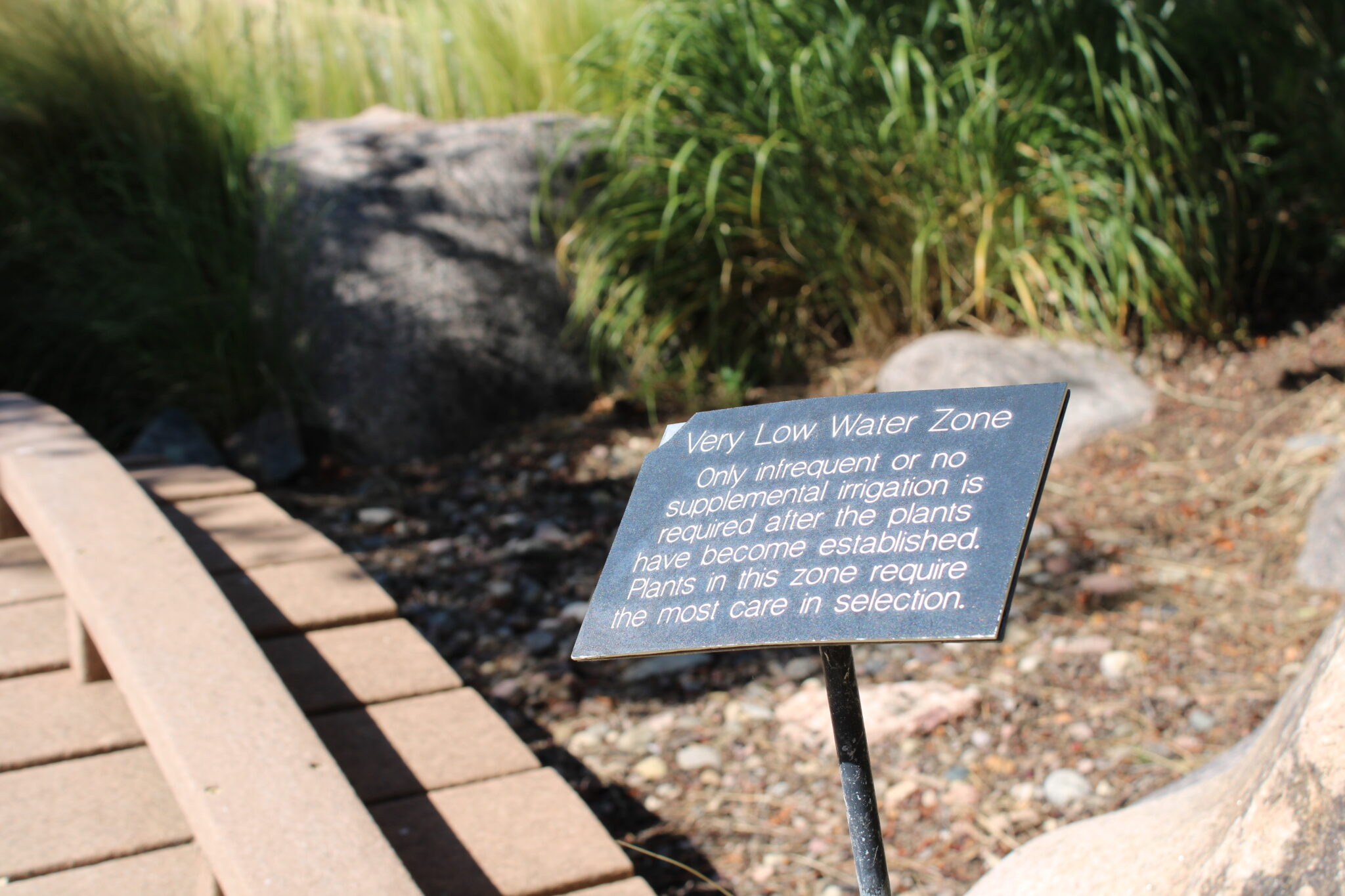
A sign indicates where to find low water use plants in Colorado Springs Utilities demonstration garden on Sept. 11, 2024. A punishing drought in 2002 reframed the way the community saw its reliance on the shrinking Colorado River. (Luke Runyon/The Water Desk)
Conserving the way out
While city leaders are proud of the water conservation success they’ve had over the past two decades, they say that was the easy part. In Colorado Springs, another 40% reduction in use over the next few decades will be tough, if not impossible, Winter said.
“Used to be that we could put a conservation program out there and anyone could participate. Almost everyone was inefficient, and so you could just broadcast a program out there and it worked,” he said. “It’s getting harder, it’s getting more expensive. We’re having to get a lot more strategic and targeted in our approach.”
The same is true just to the north, in Aurora. The city grew by 40% from 2000 to 2020, while lowering both its total water use and per-person use, according to Richter’s study.
“We are the first city (in Colorado) to pass a turf ban,” said Alex Davis, assistant general manager for Aurora Water. “Fifty percent of our use is outdoor water use in the summer, and we’re trying to ratchet that down.”
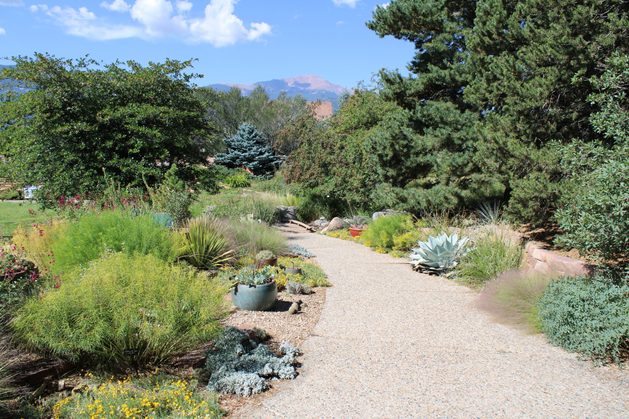
A path winds through the Colorado Springs Utilities demonstration garden on Sept. 11, 2024. Because of gradual water conservation measures the city has been able to add thousands of new residents while using less water from the Colorado River basin. (Luke Runyon/The Water Desk)
But Davis isn’t convinced a city like Aurora, with its steep population curve, can rely solely on conservation to make its way toward a stable water future.
“When we look at our demand projections going forward, we have a gap that we need to fill, right?” she said. “We have a projected need that we can’t meet today for what we expect the population to be in 2060, and so we have to acquire more water resources and do more supply projects in order to meet that gap.”
A big portion of that gap is being driven by climate change, Davis said. Longer, hotter dry spells mean the uncertainty about future water supplies is greater than it was 20 years ago. Her team uses models to game out what kinds of policies the city might need to make it through extreme droughts.
Under those severe scenarios, Aurora’s plans indicate it would first cut down on outdoor watering, then eliminate it all together. That would leave just indoor, household use, but Davis said, “there are projections where we don’t have enough water to meet household use only in these very severe projected scenarios.”
John Fleck, a University of New Mexico water policy professor, said this is the challenging future facing many of the West’s municipal water leaders. Even so, he cautioned against too much hand-wringing over population growth and urban water use. There’s still a lot of slack in the system and a lot more savings to be had, he said.
Because so much water is used outdoors, Western cities face a fundamental question: As the region warms and dries, how much green space are they willing to part with to close the gap between supply and demand? It’ll be a tough call, but not an impossible one, Fleck said.
“When you think deeply about it, it would be weird for people, for communities, not to take the necessary steps to ensure their future existence, right?” he said.
“If you’re facing the choice of getting rid of some swimming pools and lawns, or abandoning your city, it’s a no-brainer. People are going to use less water. And that’s what we see happen over and over again.”
This story is part of a series on water myths and misconceptions, produced by KUNC, The Colorado Sun, Aspen Journalism, Fresh Water News and The Water Desk at the University of Colorado Boulder.
Mrs. Gulch’s landscape September 12, 2024. Blue Gramma in the far left corner of the photo.
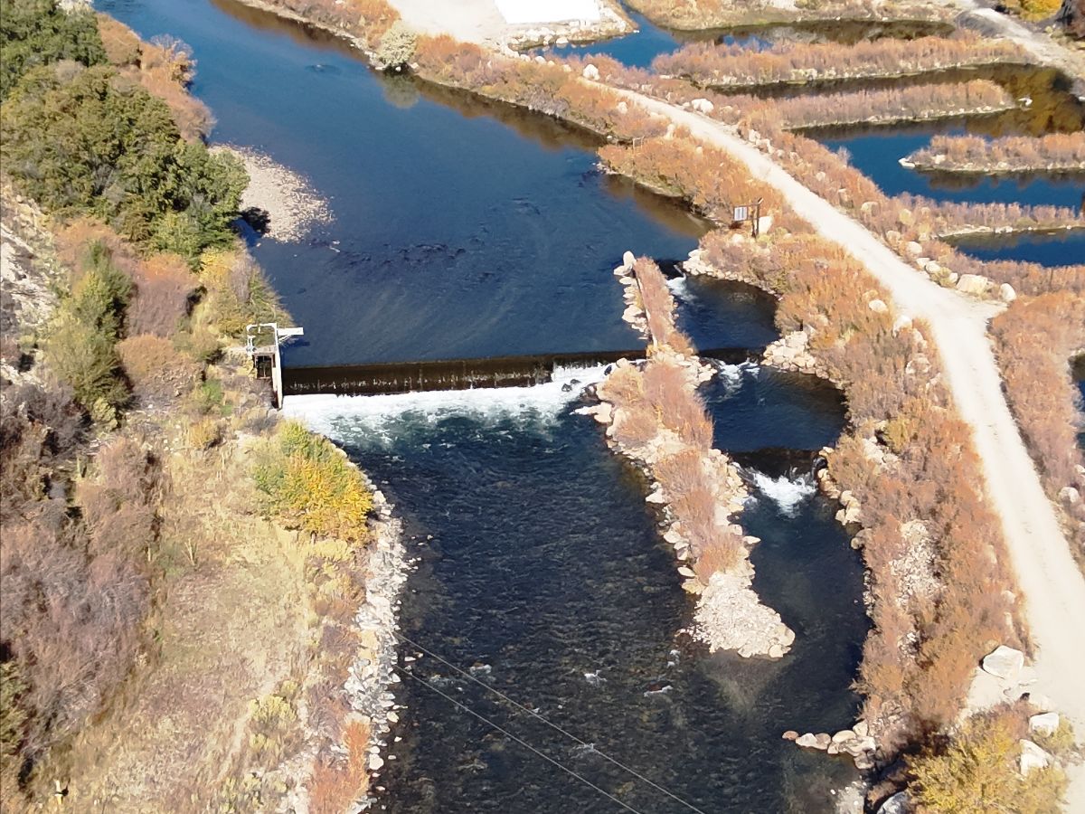
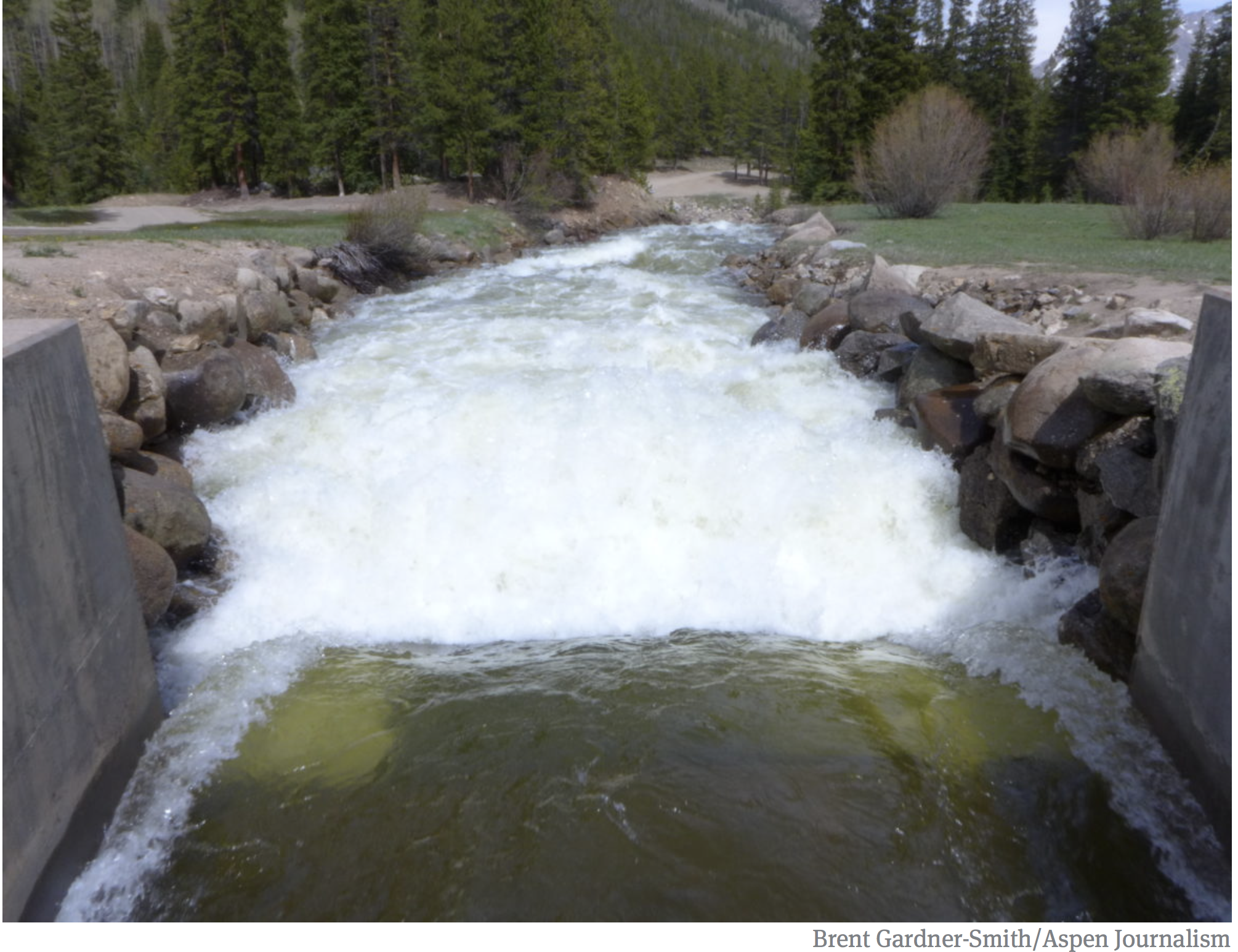
Utilities Engineer for the City of Aspen Phil Overeynder at the hydroelectric plant at Ruedi Reservoir. Releases from the reservoir in recent years have been too high in the summer and too low in the winter for Aspen to make hydropower efficiently. Credit: Heather Sackett/Aspen Journalism
The city of Aspen wants to add a second turbine and generator unit to its hydroelectric plant at the base of Ruedi Dam, which officials say will allow for more power generation during times of high and low flows.
Officials say an additional turbine, which is estimated to cost about $4.6 million, will restore the plant’s power production capacity to its originally intended 5 megawatts and allow the city to maintain its renewable energy goals. Since 2012, increased releases from Ruedi to benefit downstream endangered fish have meant that late summer and early fall flows are too high for the existing turbine to operate efficiently.
Adding another turbine requires amending Aspen’s license for the Ruedi facility with the Federal Energy Regulatory Commission. According to the city’s draft FERC application for an amendment posted on the Aspen Community Voice website, which officials say they plan on filing by the end of the month, the timing and amount of water released from Ruedi Reservoir has changed since the hydro project began operating in 1986. Power production has diminished in recent years to just 68% of what was originally intended.
Hydroelectric Dam
“After 40 years of reservoir and hydroelectric operations, it is now clear that achieving power output (maximum capacity and energy values) that approximates the original level authorized under the license will require additional generation equipment,” the application reads.
The City of Aspen has a hydroelectric power plant at the base of Ruedi Reservoir, which helps them meet renewable energy goals. Aspen officials want to add a second turbine to make power more efficiently. Credit: Heather Sackett/Aspen Journalism
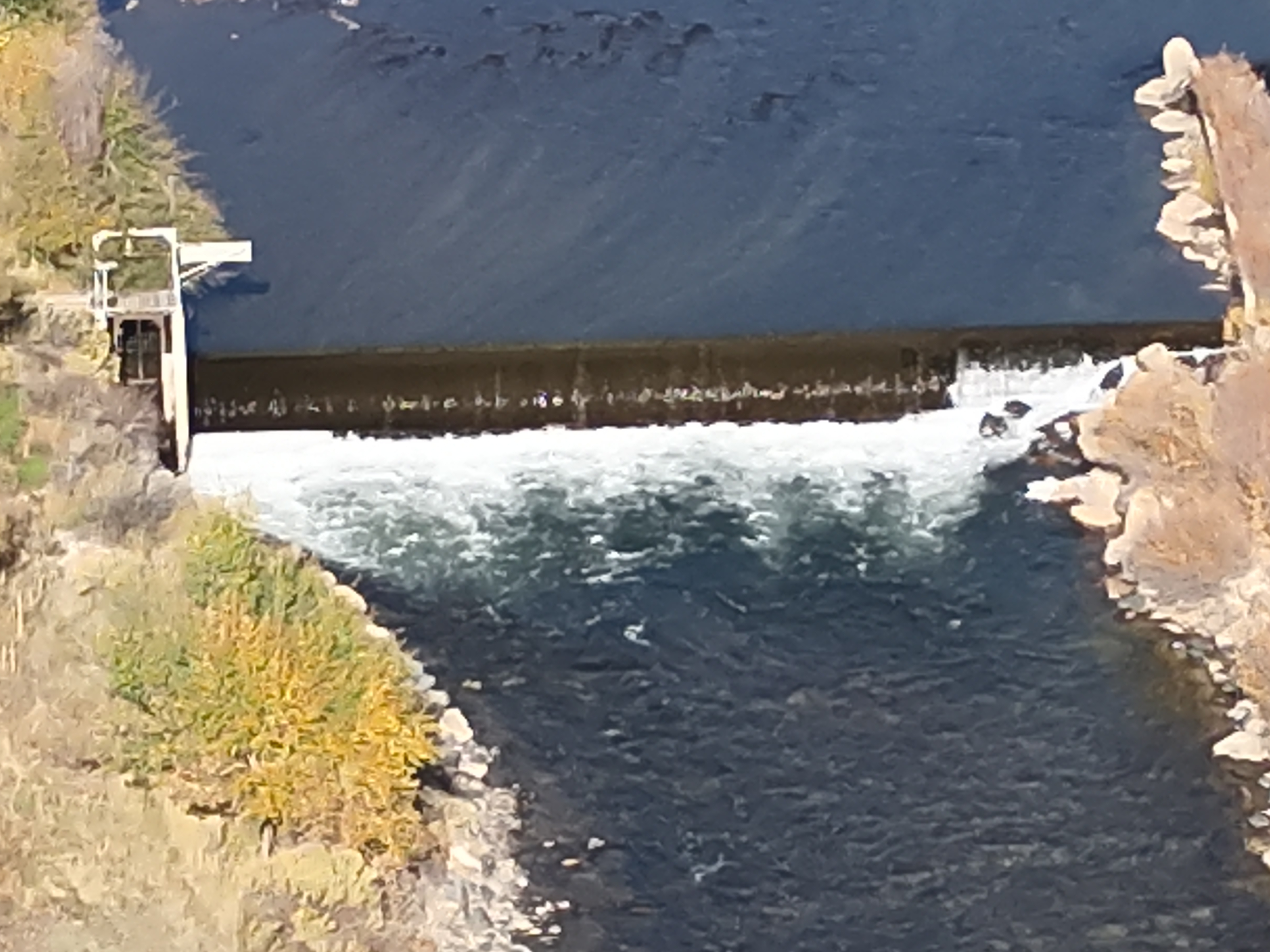
The facility is most efficient at flows between 100 and 225 cfs. But summer and fall flows are often higher than this range and winter flows often lower. Aspen has no control over how much water is released from the reservoir, which is managed by the U.S. Bureau of Reclamation.
According to the city’s application, gross energy production has declined from an average of 18.5 million kilowatt hours annually from 1986 to 2004 to 15 million kWh over the last decade.
“The equipment is kind of mismatched for what’s going on with those releases,” said Phil Overeynder, utilities engineer for the city of Aspen. “So we’re losing all of that energy above 225 cfs. If we have an additional turbine, we’ll be able to hit the sweet spot for the releases and generate the full amount of energy when it’s available.”
Also, an error in the design of the powerplant introduces air into the water column, reducing the efficiency of the turbine. Because of this flawed design, the hydro plant can’t efficiently make power above about 225 cfs. The city looked at options to fix this problem, Overeynder said, including raising the floor of the building, but the least expensive solution is adding another turbine.
A new turbine would be rated for 1.2 megawatts of production and the original turbine would be downgraded to a 3.8 megawatt capacity, for a total of 5 megawatts — the same as the plant’s current rating, but split between two turbines. During periods of higher releases, about 230 cfs would be routed through the existing turbine and 70 cfs would be routed through the new turbine for about 92% efficiency.
The project would also upgrade the hydro plant so it can be operated remotely, and would let the city continue making hydropower with one turbine if the other one is down for maintenance. The total project cost including the new turbine would be around $8.6 million, according to Overeynder.
“The proposed second turbine at Ruedi, together with other planned actions, will enable Aspen to restore the balanced power supply, which will maintain grid reliability and resiliency while continuing to provide 100% renewable energy,” the application reads.
Ruedi Reservoir on the Fryingpan River is operated by the U.S. Bureau of Reclamation. Releases for the Colorado River Endangered Fish Recovery Program have boosted late summer and fall river flows in recent years. Credit: Heather Sackett/Aspen Journalism
Fish flow
Releases out of Ruedi have changed since the hydro plant began operating, with the reservoir now one of the most important sources of water for the Colorado River Endangered Fish Recovery Program. The program, designed to get water into a chronically de-watered section of the Colorado River near Grand Junction known as the 15-mile reach, has about 15,000 acre-feet of water available most years in Ruedi. Entities that own water in Ruedi such as Garfield County, Caerus Energy, Grand Junction area water provider Ute Water and the Colorado River Water Conservation District have also in recent years leased their water to the recovery program to boost flows beyond the dedicated 15,000 acre-foot pool.
All of the recovery program’s releases are made in July through October, when streamflows naturally are reduced, but irrigation demands in the Grand Valley leave diminished river levels for endangered fish. According to numbers provided by recovery program staff, the Ruedi fish water releases increased from an average of 18,586 acre-feet in the time period from 1998 to 2012, to 20,460 acre-feet in the time period of 2013-2023.
“Ruedi is an essential piece of our ability to manage water for the endangered fish,” said Juile Stahli, director of the Upper Colorado Endangered Fish Recovery Program. “Ruedi has become really critical in helping us affect the ecology downstream.”
According to Tim Miller, a hydrologist with the U.S. Bureau of Reclamation who manages Ruedi, the current reservoir release pattern — higher flows in the late summer and lower flows in the winter — began after 2012 when the water in the reservoir was fully contracted. The owners of this contracted water (like those mentioned above) release it when they need it, and many lease it to the recovery program. Because more contract water is released from Ruedi, Miller said he has to make up that loss to the reservoir by releasing less water over the winter, resulting in low winter flows.
“I can tell you with absolute certainty that since Ruedi has been fully contracted we have released more water for fish augmentation than we did since the program started,” Miller said. “Because we’ve released more contract water, given an average fill, it’s going to take more water to fill the reservoir the next year. So my releases during the winter were lower to recover that.”
According to data from USBR, the average flow out of the reservoir from July to October before the endangered fish recovery program started from 1980 to 1997 was 180 cfs. The average release after the program began in 1998 has been 204 cfs. The number of days releases have exceeded 225 cfs has also been trending upward since the recovery program began.
Aspen’s 100% renewable energy goals
Aspen first achieved its goal of 100% renewable energy in 2015, when a project that retrofit the Ridgway Reservoir dam in the Uncompahgre River basin to generate hydroelectric power came online. The city of Aspen was integral in launching the project, funding a feasibility study in the early 2000s and signing a 10-year contract in 2012 to purchase about 10 million kwh a year from Ridgway once it became available. Ridgway now accounts for about one-seventh of Aspen’s total power portfolio, according to Overeynder. In an effort to continue meeting its 100% renewable goal, the city is also looking to continue and potentially expand its hydroelectric power generation capacity on Maroon Creek.
Aspen has begun the process of relicensing the project with FERC, which is smaller than the Ruedi project and has a capacity of 450 kilowatts. Aspen is also proposing to add additional units on Maroon Creek for a total of 500 kw.
Hydropower, including energy Aspen buys from projects at Ridgway Reservoir and Western Area Power Administration, is supposed to make up about 45% of the city’s energy portfolio. But that percentage has dropped with the declining power production at Ruedi in recent years. The city also buys wind and solar power to achieve 100% renewable energy.
“If we do this (project at Ruedi) plus what we did already at Ridgway and are proposing to do at Maroon Creek, we will get back up to that 45%,” said Justin Forman, Aspen’s Utilities Director. “For us, every megawatt counts and if it’s something local like this, we’re super proud of it and it certainly fits into the values that we have.”
The FERC relicensing process will take several years, with sign-offs also needed from the Colorado Department of Public Health and Environment, the U.S. Army Corps of Engineers and Pitkin County. Overeynder expects the new turbine to be operating sometime in 2027.
The city of Aspen supports Aspen Journalism with a community nonprofit grant. Aspen Journalism is solely responsible for its editorial content.
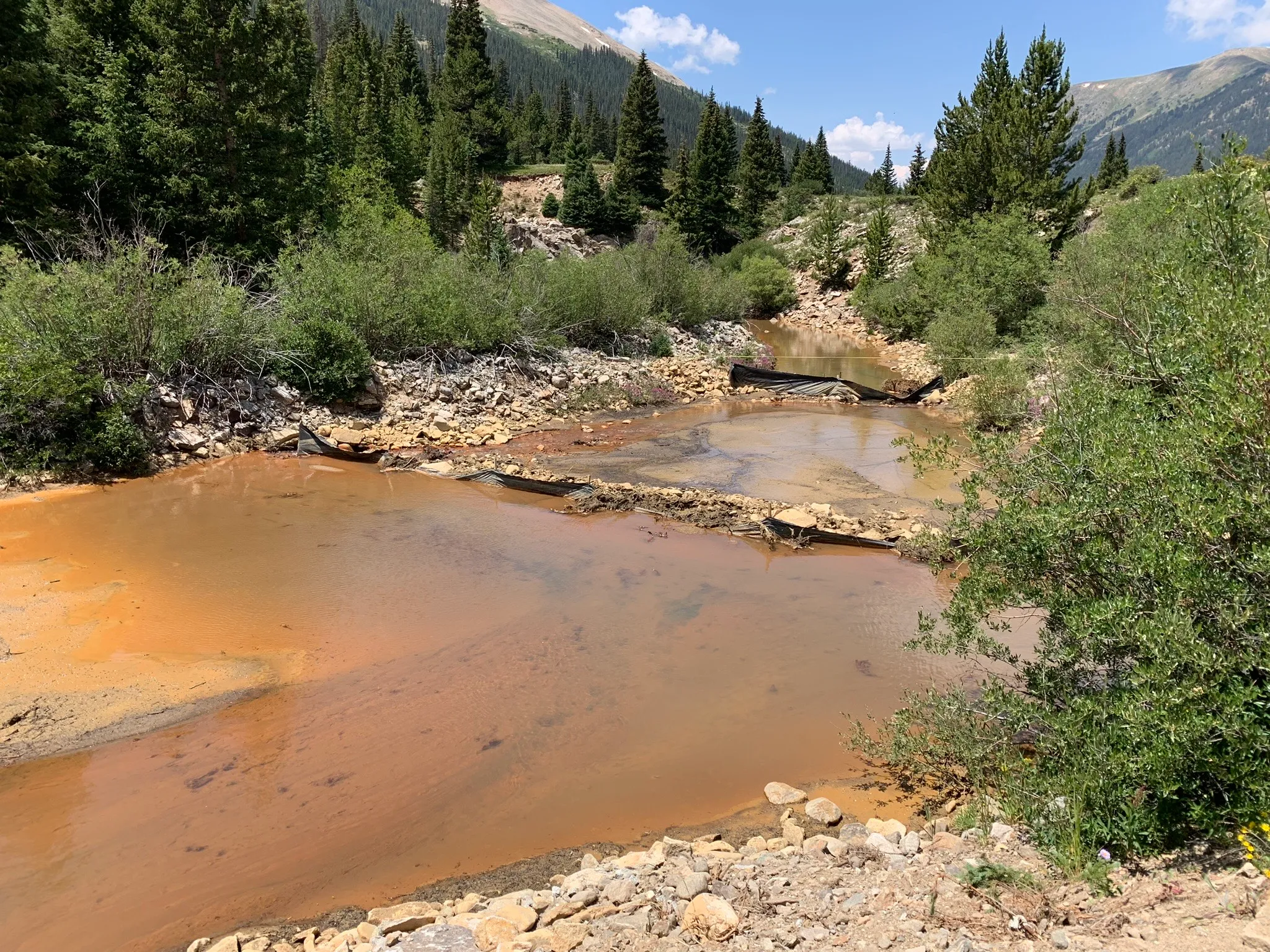
These sediment traps of hay bales and tarps, seen on July 21, were placed in Lincoln Creek below Grizzly Reservoir. Pitkin County officials say that a July 16 release from Grizzly Reservoir that turned Lincoln Creek and the Roaring Fork River orange had minimal biological effects on fish and other aquatic life. Credit: Heather Sackett/Aspen Journalism
Pitkin County officials say that a July release from Grizzly Reservoir that turned Lincoln Creek and the Roaring Fork River orange had minimal biological effects on fish and other aquatic life.
Water quality testing results from the day of the sediment release, July 16, show high levels of iron and aluminum, but they do not show levels of copper high enough to be toxic to fish.
Members of the Lincoln Creek workgroup, which is comprised of officials from Pitkin County, Colorado Parks & Wildlife, Colorado Department of Public Health and Environment, Independence Pass Foundation and others, met remotely on Wednesday to debrief the July 16 incident. The water quality samples were collected by staff from the Roaring Fork Conservancy and the results are available on River Watch, a statewide volunteer water quality monitoring program operated by CPW.
The released sediment was in particulate form and less able to be readily taken up by aquatic life, according to a press release from Pitkin County. There were no fish kills reported to CPW and the event is not expected to have a significant long-term impact on aquatic ecosystems.
“Most of this indicates that although visually the impact of the event was, you know, scary to look at, it does seem that at least from a copper and biological perspective that there was less of a copper biological risk to fish,” said Megan McConville, CPW River Watch program manager. “The copper has a more toxic effect on aquatic life than the aluminum or the iron.”
Twin Lakes Reservoir & Canal Co., which operates Grizzly Reservoir, drained the reservoir this summer so it could make repairs to the dam and outlet works. On July 16, a pulse of sediment-laden water from the bottom of the reservoir was released down Lincoln Creek, turning it and the Roaring Fork River orange and alarming Aspen residents and visitors.
A July 1 news release from Pitkin County had warned of the potential for temporary discoloration of the river as the reservoir was drawn down, but the severity of the event shocked many people. The U.S. Army Corps of Engineers is investigating whether the sediment release needed a permit under the Clean Water Act.
Officials say the release is unlikely to pose any ongoing risk to people recreating in local waterways.
Local officials, residents and environmental groups have long been concerned about water quality on Lincoln Creek and the July 16 release came at a time of increased scrutiny. Officials have determined that a “mineralized tributary,” which feeds into Lincoln Creek above the reservoir near the ghost town of Ruby, is the source of the high concentrations of metals downstream. The contamination seems to have been increasing in recent years and may be exacerbated by climate change as temperatures rise.
High levels of aluminum, iron at testing sites
Water quality samples were taken by Roaring Fork Conservancy staff at six locations on Lincoln Creek and the Roaring Fork on three dates: June 4, June 25 and July 16. The locations were the Grizzly Reservoir inlet, below Grizzly Dam, the Lincoln Gulch Campground on the creek just above the confluence with the the Roaring Fork, the Grottos day-use area and Difficult Campground. Control samples were also taken from the Roaring Fork just above the Lincoln Creek confluence. An additional location, below the sediment traps on Lincoln Creek about 50 yards below Grizzly Dam, was tested only on July 16.
That data show sharply increasing concentrations of aluminum and iron on July 16, particularly just below the dam. On June 25, there were 258 micrograms (parts per billion) of aluminum in the water below Grizzly Dam, which is still exceeds the chronic water quality standard for aquatic life (on all but one date and location, the amount of aluminum exceeded either the CPW acute or chronic water quality standards for aquatic life). During the release on July 16, that jumped to 1.7 million micrograms. Testing at the second location below the dam, below the sediment traps placed by Twin Lakes, that number was down to 726,600.
“There was a pretty significant drop from what was coming directly out of the dam,” said Chad Rudow, water quality program manager with the Roaring Fork Conservancy. “It kind of shows the sediment traps were doing their job and helping to sequester some of that stuff.”
By the time the release had made it downstream to the confluence of the Roaring Fork, the total iron levels had decreased by 97%, and total aluminum decreased by 98%.
Because there were additional elements in the water, the aluminum was not as toxic to fish as it could have been, McConville said.
“The more carbon you have in the water, the less toxic it makes the aluminum,” she said. “Because we’ve got bottom lake sediments coming down, they were probably pretty high in carbon. … My guess is that a big slug of carbon came down along with the iron and aluminum and for aluminum in particular, it probably provided some protection for those aquatic organisms.”
The iron levels also exceeded state chronic water quality standards for aquatic life in eight of the 19 sites and days tested, but iron is a 30-day standard and the release was a roughly 36-hour event.
“If that event had gone on for 30 days or a longer duration, then that standard would have been applicable,” McConville said. “But because it was such a short-term event, that sort of clogging, smothering effect that we would expect from that precipitated iron just really didn’t have a chance to occur.”
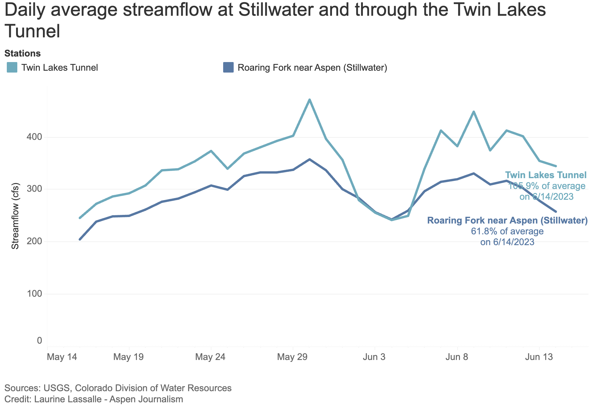
The reason copper levels below the reservoir were so low is probably because the entirety of Lincoln Creek above the reservoir — the source of copper contamination — is being diverted to the Arkansas River basin through the Twin Lakes Tunnel.
A map of the Independence Pass Transmountain Diversion System, as submitted to Div. 5 Water Court by Twin Lakes Reservoir and Canal Co.
Lincoln Creek and Grizzly Reservoir are part of a highly engineered system that takes about 40% of the water from the headwaters of the Roaring Fork to cities and farms on the east side of the Continental Divide. Water is sent from the reservoir through Twin Lakes Tunnel into Lake Creek, which is then collected in Twin Lakes Reservoir.
Four municipalities own 95% of the shares of water from the Twin Lakes system: Colorado Springs Utilities owns 55%; the Board of Water Works of Pueblo has 23%; Pueblo West Metropolitan District owns 12% and the city of Aurora has 5%.
Officials said at Wednesday’s meeting that this is just the initial attempt at understanding the water quality testing data around one reservoir release event and there is still a lot of data that needs to be analyzed from other testing agencies.
In addition to the Roaring Fork Conservancy, four other entities are conducting water quality sampling this summer: Pitkin County Environmental Health; the U.S. Forest Service; Colorado Parks and Wildlife; and the Institute of Arctic and Alpine Research at the University of Colorado Boulder. The workgroup has hired consultant LRE Water to review the data and an EPA report, make a site visit and comment on the sampling plans of the five different entities.
“The initial plan was to have all of the data come to us at one time, the beginning of next year, but there became this ask for the data around this event; there was a concern around toxicity,” said Kurt Dahl, Pitkin County environmental health director. “There’s still a lot of data that we have out there. … The context of the entire year is going to have to wait until our intended timeframe of early next year to talk about how this looks in comparison to the various other times we’re out there sampling.”
Prior to mining, snowmelt and rain seep into natural cracks and fractures, eventually emerging as a freshwater spring (usually). Graphic credit: Jonathan Thompson
A pilot wastewater treatment project in the Wet Mountain Valley west of Pueblo just got a boost from a state grant. The project is designed to address challenges some small communities are having in meeting increasing federal environmental standards combined with the demands created by a growing population. The system calls for upgraded wastewater lagoons stocked with specialized microbes, as well as a technology known as electrocoagulation to help clean sewage from water. Dave Schneider manages the Round Mountain Water and Sanitation District in Westcliffe and Silver Cliff. He said they’ve run small scale tests that show their concept works. The next step is to run a larger scale test on the upgraded lagoon system. They’ll also do separate assessments of the electrocoagulation component to determine whether it is necessary.
“What are the challenges we have (on a) big scale?” he said. “We might have to do one or two different tweaks that we might not have initially planned, but we’re going to find a methodology in this that will work.”
The state Department of Local Affairs awarded a $546,750 grant to the district to help fund the $800,000 pilot project…Schneider said they hope to submit the plans for the demonstration project to the state health department for approval this fall and get the upgrades started next spring.
Coal fired plant near Hayden with the Yampa River 2015. Photo credit: Ken Nuebecker
Click the link to read the article on the Big Pivots website (Allen Best):
August 17, 2024
Will there be a water bonus as we close coal plants? In the short term, yes. It’s harder to say in the long term. Here’s why.
Use it or lose it. That’s a basic premise of Colorado water law. Those with water rights must put the water to beneficial use or risk losing the rights to somebody who can. It’s fundamentally anti-speculative. But Colorado legislators this year created a major exception for two electric utilities that draw water from the Yampa River for coal-burning power plants. They did so through Senate Bill 24-197, which Gov. Jared Polis signed into law in Steamboat Springs in late May.
The two utilities, Xcel Energy and Tri-State Generation and Transmission Association, plan to retire the five coal-burning units — two at Hayden and three at Craig — they operate in the Yampa River Basin by late 2028. These units represent Colorado’s largest concentration of coal plants, 1,874 megawatts of generating capacity altogether. That’s 40% of Colorado’s total coal-fired electrical generation. Together, they use some 19,000 acre-feet of water each year.
What will become of those water rights when the turbines cease to spin? And what will replace that power? The short answer is that the utilities don’t know. That’s the point of the legislation. It gives the utilities until 2050 to figure out their future.
While the legislation is unique to the Yampa Valley, questions of future water use echo across Colorado as its coal plants — two units at Pueblo, one near Colorado Springs, one north of Fort Collins, and one at Brush — all will close or be converted to natural gas by the end of 2030.
This story was originally published in the July 2024 issue of Headwaters Magazine. Photo above of the Hayden Generating Station and the Yampa River was taken by Ken Neubecker in spring 2015. All other photos by Allen Best unless otherwise noted.
Both Xcel and Tri-State expect that at least 70% of the electricity they deliver in 2030 will come from wind and solar. The final stretch to 100%? That’s the hard question facing utilities across Colorado — and the nation and world.
Natural gas is expected to play a continued role as backup to the intermittency of renewables. Moving completely beyond fossil fuels? No one technology or even a suite of technologies has yet emerged as cost-effective. At least some of the technologies that Xcel and Tri-State are looking at involve water.
Fossil fuel plants use less than 1% of all of Colorado’s water. Yet in a state with virtually no raw water resources left to develop, even relatively small uses have gained attention. Colorado’s power future will have implications for its communities and their water, but how exactly that will look remains unknown.
Emissions Goals
The year 2019 was pivotal in Colorado’s energy transition. State lawmakers adopted legislation that specified a 50% economy-wide reduction in greenhouse gas emissions by 2030 and 100% by 2050. A decade before, that bill would have been laughed out of the Colorado Capitol. Even in 2019, some thought it unrealistic. But proponents had the votes, and a governor who had run on a platform of renewable energy.
Something approaching consensus had been achieved regarding the risks posed by climate change. Costs of renewables had plummeted during the prior decade, 70% for wind and 89% for solar, according to the 2019 report by Lazard, a financial analyst. Utilities had learned how to integrate high levels of renewables into their power supplies without imperiling reliability. Lithium-ion batteries that can store up to four hours of energy were also dropping in price.
Colorado lawmakers have adopted dozens of laws since 2019 intended to dramatically reduce greenhouse gas emissions. Photo credit: Allen Best/Big Pivots
Tied at the legislative hip to the targets adopted in 2019 were mandates to Colorado’s two investor-owned electric utilities, Xcel Energy and Black Hills Energy. By 2030 they must reduce emissions by at least 80% compared to 2005 levels. Both aim to do even better.
Xcel, the largest electrical utility in Colorado, was already pivoting. In 2017, it received bids from wind and solar developers in response to an all-sources solicitation that caused jaws across the nation to drop. In December 2018 shortly after the election of Gov. Polis, Xcel officials gathered in Denver to boldly declare plans to reduce emissions by 80% by 2030. Platte River Power Authority, the provider for Fort Collins and three other cities in the northern Front Range, later that month adopted a highly conditioned 100% goal. In January 2020, Tri-State announced its plans to close coal plants and accelerate its shift to renewables — it plans to reduce emissions by 89% by 2030. In December 2021, Holy Cross Energy, the electrical cooperative serving the Vail and Aspen areas, adopted a 100% goal for 2030. It expects to get to 91% by 2025.
Colorado Springs Utilities burned the last coal at the Martin Drake power plant along Fountain Creek in August 2022. Photo credit: Allen Best/Big Pivots
Colorado’s emissions-reduction goals are economy wide, not just for power production. In practice, this means replacing technologies in transportation, buildings and other sectors that produce greenhouse gas emissions with low- or no-emissions energy sources. As coal plants have closed, transportation has become the highest-emitting sector. Colorado had 126,000 registered electric vehicles and hybrids as of June but hopes to have 940,000 registered by 2030. Buildings pose a greater challenge because most of us don’t replace houses the way we do cars or cell phones. Solutions vary, but many involve increased use of electricity instead of natural gas.
A final twist that has some bearing on water is Colorado’s goal of a “just transition.” House Bill 19-1314 declared that coal-sector workers and communities were not to be cast aside. Efforts would be made to keep them economically and culturally whole.
Possible Water Dividends
The Cherokee Generating Station north of downtown Denver is now a natural gas-fired power plant.
Where does this leave water? That’s unclear and, as the 2024 legislation regarding the Yampa Valley spelled out, it is likely to remain unclear for some time. The law prohibits the Division 6 water judge — for the Yampa, White and North Platte river basins — from considering the decrease in use or nonuse of a water right owned by an electric utility in the Yampa Valley.
In other words, they can sit on these water rights through 2050 while they try to figure what technologies will emerge as cost competitive. Xcel Energy and Tri-State will not lose their water rights simply because they’re not using them during this time as would, at least theoretically, be the case with other water users in Colorado.
Conversion of the Cherokee power plant north of downtown Denver from coal to natural gas provides one case study of how energy shifts can affect water resources. Xcel converted the plant to natural gas between 2010 and 2015. Its capacity is now 928 megawatts.
Richard Belt, a water resources consultant for Xcel, says that when Cherokee still burned coal, it used 7,000 to 8,000 acre-feet of water per year; since 2017, when natural gas replaced coal, it uses 3,000 to 3,500 acre-feet per year.
Does that saved water now flow downstream to farmers in northeastern Colorado?
“If the wind is really blowing, there could be some water heading downstream on certain days,” Belt answered. In other words, there’s so much renewable energy in the grid that production from the gas plant at times is not needed. A more concrete way to look at this conversion, Belt says, is to step back and look at Xcel’s water use more broadly across its system. It also has the Rocky Mountain Energy Center, a 685-megawatt combined-cycle natural gas plant along Interstate 76 near Keenesburg that it bought in 2009 and began operating in 2012. With the plant came a water contract from Aurora Water.
Xcel has been renegotiating that contract, which it projects will be effective in early 2025. The new contract will allow Xcel to take water saved at Cherokee and instead use it at the Rocky Mountain Energy Center. That will allow it to use 2,000 acre-feet less of the water it has been leasing from Aurora each year. Belt says it will save Xcel customers around $1 million a year in water costs.
“Another way to look at this dividend is that we’re going to hand [Aurora] two-thirds of this contract volume, around 2,000 acre-feet a year, and they can use that water within their system,” Belt explains.
Other coal-burning power plants have also closed in recent years, with water dividends of their own. One small coal plant in southwestern Colorado at Nucla, operated by Tri-State, was closed in 2019. In 2022, Xcel shut down one of its three coal units at the Comanche Generating Station in Pueblo.
Colorado Springs Utilities stopped burning coal at its Martin Drake coal-fired plant in 2021, which is located near the city’s center, and replaced it with natural gas. It used some 2,000 acre-feet of water per year in the early 2000s, and was down to only 14 acre-feet per year in 2023. Colorado Springs Utilities — a provider of both electricity and water — delivers 70,000 to 75,000 acre-feet of water annually to its customers. Whatever water savings were achieved in that transition will be folded into the broader operations. The city’s remaining coal plant, Ray Nixon, burns both coal and natural gas. The city delivers about 2,000 acre-feet per year to Nixon to augment groundwater use there.
The 280-megawatt Rawhide coal-fired power plant north of Fort Collins is to be shut down by 2030. Platte River Power Authority, which owns and operates the plant, had not yet chosen a replacement power source as of June 2024. Platte River delivers electricity to Estes Park, Fort Collins, Longmont and Loveland.
The Cherokee plant along the South Platte River north of downtown Denver uses significantly less water since tis conversion from coal to natural gas. Photo credit: Allen Best/Big Pivots
That leaves just the 505-megawatt Pawnee among Colorado’s existing coal plants. The plant near Brush is to be retrofitted to burn natural gas by 2026. The water dividend? Xcel is trying to keep its options open.
The one commonality among all the possible power-generating technologies that Xcel may use to achieve its goal of emissions-free energy by 2050 is that, with the exception of some battery technologies, they all require water, says Belt. And that, he says, means it would be unwise to relinquish water without first making decisions about the future.
That’s why this year’s bill was needed. Colorado’s two biggest electrical providers, Xcel and Tri-State, both with coal plants retiring in the Yampa Valley, have questions unanswered.
The Future of Energy
Strontia Springs Dam and Reservoir, located on the South Platte River within Waterton Canyon. It is ranked #32 out of 45 hydroelectric power plants in Colorado in terms of total annual net electricity generation. Photo by Milehightraveler/iStock
What comes next? Obviously, lots more wind and solar. Lots. The graph of projected solar power in Colorado through this decade looks like the Great Plains rising up to Longs Peak. Construction of Xcel’s Colorado Power Pathway, a 450-mile transmission line looping around the Eastern Plains, will expedite renewables coming online. Tri-State is also constructing new transmission lines in eastern Colorado. The plains landscape, San Luis Valley, and other locations could look very different by the end of the decade.
Very little water is needed for renewables, at least once the towers and panels are put into place.
You may well point out that the sun goes down, and the wind doesn’t always blow. Storage is one holy grail in this energy transition. Lithium-ion batteries can store energy for four hours. That works very effectively until it doesn’t. Needed are new cost-effective technologies or far more application of known technologies.
One possible storage method, called iron-rust, will likely be tested at Pueblo in 2025 by a collaboration between Xcel and Form Energy, a company that proclaims it will transform the grid. It could provide 100 hours of storage. Tri-State’s electric resource plan identifies the same technology.
Granby Dam was retrofitted at a cost of $5.1 million to produce hydroelectricity effective May 2016. It produces enough electricity for about 570 homes. Photo/Northern Water
Other potential storage technologies involve water. Pumped-storage hydropower is an old and proven technology. It requires vertical differences in elevation, and Colorado has that. In practice, finding the right spots for the two reservoirs, higher and lower, is difficult.
Xcel Energy’s Cabin Creek project between Georgetown and Guanella Pass began electrical production in 1967. In this closed-loop system, water from the higher reservoir is released through a three-quarter-mile tunnel to the second reservoir 1,192 feet lower in elevation. This generates a maximum 324 megawatts to help meet peak demands or to provide power when it’s dark or the wind stops blowing. When electricity is more freely available, the water can be pumped back to the higher reservoir. Very little water is lost.
Near Leadville, the U.S. Bureau of Reclamation has a pumped-storage hydropower project at Twin Lakes, the Mt. Elbert Power Plant, with a more modest elevation difference. The plant can generate up to 200 megawatts of electricity.
Graphic credit: Joan Carstensen
A private developer with something similar in mind has reported reaching agreements with private landowners along the Yampa River between Hayden and Craig. With private landowners, the approval process would be far easier than if this were located on federal lands. Cost is estimated at $1.5 billion.
Belt points out that the Federal Energy Regulatory Commission has streamlined the permitting process for pumped-storage hydro but that technology remains expensive and projects will take probably 10 to 12 years to develop if everything goes well.
“During that 10 to 12 years, does something new come along? And if you’re committed to pumped storage, then you can’t pivot to this new thing without a financial impact,” he says, explaining a hesitancy around pumped storage.
Green hydrogen is another leading candidate in the Yampa Valley and elsewhere. It uses electrolysis to separate the hydrogen and oxygen in water. Renewable energy can be used to fuel the electrolysis. That’s why it is called green hydrogen as distinct from blue hydrogen, which uses natural gas as a catalyst. A news story in 2023 called it a “distant proposition.” Costs remain high but are falling. Tax incentives seek to spur that innovation.
Gov. Polis’ administration remains optimistic about hydrogen. It participated in a proposal for federal funding that would have created underground hydrogen storage near Brush. That proposal was rejected, but Will Toor, the chief executive of the Colorado Energy Office, has made it clear that green hydrogen and other emerging technologies remain on the table. Xcel says the same thing. “It’s not something we are going to give up on quite yet,” says Belt. The water savings from the conversion of coal to natural gas could possibly play into those plans.
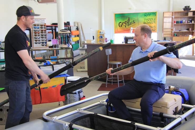
Gov. Jared Polis stopped by the Good Vibes River Gear in Craig in March 2020 prior to attending a just transition workshop. Photo credit: Allen Best/Big Pivots
Polis is bullish on geothermal, both kinds. The easier geothermal uses the relatively constant 55 degree temperatures found 8 to 10 feet below ground to heat and cool buildings. The Colorado Capitol has geothermal heating, but the most famous example is Colorado Mesa University, where geothermal heats and cools about 80% of the campus. This technology may come on strong in Colorado, especially in new construction.
Can heat found at greater depths, say 10,000 feet or from particularly hot spots near the surface, be mined to produce electricity? California generates 10.1% from enhanced geothermal, Nevada 5.1%, and Utah 1.5%. Colorado generates zero. At a June conference, Polis said he thought geothermal could produce 4% to even 8% of the state’s electricity by 2040. Geothermal for electric production would require modest water resources.
Nuclear? Those plants, like coal, require water. Many smart people believe it may be the only way that civilization can reduce emissions as rapidly as climate scientists say is necessary to avoid catastrophic repercussions. Others see it as a way to accomplish just transition as coal plants retire.
Costs of traditional nuclear remain daunting. Critics point to projects in other states. In Georgia, for example, a pair of reactors called Vogtle have been completed but seven years late and at a cost of $35 billion, more than double the project’s initially estimated $14 billion price tag. The two reactors have a combined generating capacity of 2,430 megawatts.
New reactor designs may lower costs. The Nuclear Regulatory Commission in 2023 certified design of a small-modular reactor by NuScale. It was heralded as a breakthrough, but NuScale cancelled a contract later that year for a plant in Idaho, citing escalating costs.
With a sodium fast reactor, integrated energy storage and flexible power production, the Natrium technology offers carbon-free energy at a competitive cost and is ready to integrate seamlessly into electric grids with high levels of renewables. Graphic credit: http://NatriumPower.com
Greater optimism has buoyed plans in Wyoming by the Bill Gates-backed TerraPower for a 345-megawatt nuclear plant near the site of a coal plant at Kemmerer. It has several innovations, including molten salt for energy storage and a design that allows more flexible generation, creating a better fit with renewables. Ground was broken in June for one building. An application for the design is pending with the U.S. Nuclear Regulatory Commission. Gates has invested $1 billion and expects to invest many billions more in what he estimates will be a $10 billion final cost. He also hopes to see about 100 similar plants and reduced costs. Other companies with still other designs and ideas say they can also reduce costs. All these lower-cost nuclear solutions exist in models, not on the ground. Uranium supply remains problematic, at least for now, but more difficult yet is the question of radioactive waste disposal.
Into The Future
The potential for nuclear is balled up in the issue of just transition. Legislators in 2019 said that coal communities would not be left on their own to figure out their futures. What this means in practice remains fuzzy.
Consider Pueblo. Xcel Energy on August 1 is scheduled to submit to the Colorado Public Utilities Commission what is being called the Pueblo Just Transition Electric Resource Plan. Through that plan, Xcel must determine to what extent it can, through new generating sources, leave Pueblo economically whole after it closes the coal plants. Existing jobs will be lost, although others in post-closure remediation of the site will be gained. What, then, constitutes a just transition for Pueblo?
What will Xcel propose in October for Pueblo as it makes plans for the retired of the last of the Comanche coal-burning units in 2030? Photo credit: Allen Best/Big Pivots
A task force assembled by Xcel Energy in January delivered its conclusions after nearly a year of study: “Of all of the technologies that we studied, only advanced nuclear generation will make Pueblo whole and also provide a path to prosperity,” concluded the task force. They advised that a natural gas plant with carbon capture would be a distinctly secondary choice.
What will happen with the water in Pueblo? Xcel Energy has a take-or-pay water contract with Pueblo Water for 12,783 acre-feet per year for the Comanche Generating Station. It must pay for the water even if it does not take it. Pueblo Water has a similar take-or-pay contract for 1,000 acre-feet annually for the 440-megawatt natural gas plant operated by Black Hills Energy near the Pueblo airport.
The draw of these water leases from the Arkansas River isn’t that notable, says Chris Woodka, president of the Pueblo Water board, even in what he describes as a “small year,” with low flows in the river. These water leases constitute some 5% or less of the river’s water, Woodka says. Xcel could tap that same lease for whatever it plans at Pueblo. And if it has no use? “We haven’t had many conversations around what we would do if that lease goes away, because it is so far out in the future.”
Xcel and Tri-State both own considerable water rights in the lower Arkansas Valley, near Las Animas and Lamar. Neither utility has shared plans for using the water, as the ideas of coal or nuclear power plants that initially inspired the water purchases never moved forward. Water in both cases has been leased since its acquisition to Arkansas Basin agricultural producers in order to maintain an ongoing beneficial use.
Yampa River. Photo credit: Yampa River Integrated Water Management Plan website
Why don’t Tri-State and Xcel lease their water in the Yampa River as they do in the Arkansas? Jackie Brown, the senior water and natural resources advisor for Tri-State, explains that there is no demand for additional agricultural water in the Yampa Basin. About 99% of all lands capable of supporting irrigated agriculture already get water. This is almost exclusively for animal forage. This is a valley of hay.
However, the Yampa River itself needs more water. The lower portion in recent years has routinely suffered from low flows during the rising heat of summer. Some summers, flows at Deerlodge, near the entrance to Dinosaur National Monument, have drooped to 20 cubic feet per second. Even in Steamboat, upstream from the power plants, fishing and other forms of recreation, such as tubing, have at times been restricted.
One question asked in drafting the legislation this year was whether to seek protection with a temporary instream flow right for some of the 45 cfs that Tri-State and Xcel together use at the plants at Craig and Hayden. The intent would have been to protect the delivery of some portion of that water to Dinosaur National Monument through 2050. That idea met resistance from stakeholders.
Instead, a do-nothing approach was adopted. Those framing the bill expect that most of the time, most of the water will flow downstream to Dinosaur anyway. In most years, no demands are placed on the river from November through the end of June. The challenge comes from July through October. The amount of water, used formerly by coal plants, that reaches Dinosaur will depend upon conditions at any particular time. Have the soils been drying out? Has the summer monsoon arrived?
The Yampa River at Deerlodge Park July 24, 2021 downstream from the confluence with the Little Snake River. There was a ditch running in Maybell above this location. Irrigated hay looked good. Dryland hay not so much.
“Even if you’re adding even half of that [45 cfs], it is a big deal,” says Brown. “If you can double the flow of a river when it’s in dire circumstances it’s a big deal.”
A study conducted by the Colorado River Water Conservation District several years ago examined how much water released from Elkhead Reservoir, located near Hayden, would reach Dinosaur. The result: 88% to 90% did.
Brown says river managers will be closely studying whether the extra water can assist with recovery of endangered fish species and other issues. “There’s a lot of learning to be done. My key takeaway is that that’s really going to contribute to the volume of knowledge that we have and the future management decisions that are made.”
A larger takeaway about this new law is that it gives Colorado’s two biggest electrical providers time. Xcel and Tri-State don’t know all the answers as we stretch to eradicate emissions from our energy by mid-century. Many balls are in the air, some interconnected, each representing a technology that may be useful or necessary to complement the enormous potential of wind and solar generation now being created. All of these new technologies will require water. Some water in the conversion from coal is being saved now, but it’s possible it will be needed in the future.
No wonder Xcel’s Belt says its “imprudent in a very water-constrained region to let go of a water asset that you may not get back, until you know how some of these balls are going to land.”
From satellite view, the land north of the Arkansas River is a seemingly random checkerboard of vital green and desperate brown, quickly fading from a few thriving farm acres to the broad, water-drained desolation of northern Crowley County.
From the cab of Matt Heimerich’s pickup, each alternating square of emerald corn or desiccated knapweed is a decision by a distant big city — to either share Colorado resources responsibly or toss rural Arkansas River counties to the fate of the hot summer winds.
That square was reseeded with native grass after Aurora bought the water in the 1970s, Heimerich says. That plot, Colorado Springs dried up and it’s all weeds. That farm, Aurora wants to dry it up soon, but the water court referee wants a better reseeding plan.
Heimerich’s family is one of the few farmers remaining in the 790 square miles of Crowley County after city water buy-ups shrank the county’s irrigated acres from more than 50,000 in the 1970s to just a few thousand this year. He jumps down from the pickup to clear invasive kochia weeds from a pipe opening gushing cool canal water down a 1,500-foot corn row.
Straight line diagram of the Lower Arkansas Valley ditches via Headwaters Magazine
Two miles away is downtown Olney Springs, population 310. Crowley County as a whole has only 5,600 residents, and more than a third of those are inmates at two prisons. The only retail operation left in Olney Springs is a soda vending machine against the wall of town hall.
As Heimerich clears his irrigation pipe, he pauses to jab a thumb over his shoulder 150 miles to the north at Aurora, where the population increased by more than 100,000 over 20 years. “When you build a new development, at the end of the day, you’re drying up a farm,” Heimerich said. “Where else is it going to come from?”
“Crowley is just the worst example of what can happen when nobody cares, and nobody pays attention,” he said. The tiny community serves as an enduring reminder of the cultural and economic ruin that occurs when big cities in Colorado and elsewhere purchase farms, dry up the land and move the water to urban areas. It gave rise to the term “buy and dry,” a practice now widely condemned.
The practice was supposed to end in the Lower Arkansas Valley in 2003 with a hard-fought federal court battle and settlement. Since then, state lawmakers and top water and farm agencies have changed laws and spent millions of dollars testing new protective methods for sharing water temporarily between rural and urban areas. They have also spent heavily to improve water quality for thousands of people living near the river who still don’t have clean water to drink.
The big cities insist they have learned their lessons from the Crowley County disaster.
“The results of what happened in Crowley County are unacceptable and widely recognized as a travesty,” said Colorado Springs Utilities spokesperson Jennifer Jordan. “We’ve taken those lessons to heart.”
Arkansas River Basin — Graphic via the Colorado Geological Survey
But outraged Lower Arkansas growers and water districts say new efforts to protect their farm water aren’t working. At the same time, the big cities say new laws making it easier to share farm water don’t provide enough reliable water to grow their communities.
The cities also say big changes in the future water picture, climate-driven reductions in stream flows and threats to their Colorado River supplies leave them little choice but to draw more farm water.
This year they did that, inking deals in the Lower Arkansas worth more than $100 million to buy and lease land and water, raising alarms among local growers and generating big questions about whether the state is doing enough to protect rural farm communities and the water that keeps them going.
Buy and dry light
The cities say a lot has changed in the past 20 years and that these new deals represent innovations in water sharing. But critics in the Lower Arkansas Valley say these same deals signal that no one is doing enough to prevent “buy and dry” or the latest tool in the water acquisition quiver, “lease and dry,” in which water is pulled from farmland periodically.
Aurora, for instance, spent $80 million in April to buy nearly 5,000 acres of farms in Otero County and the more than 6,500 acre-feet of water associated with that land. An acre-foot equals nearly 326,000 gallons of water, enough to irrigate half an acre of corn, or supply at least two urban homes for one year.
Aurora plans to use the water itself in three out of 10 years, leaving it on the farms the rest of the time. Some 4,000 acres of land will be dried up intermittently when Aurora is using the water, according to Karl Nyquist, a developer and grower who negotiated the deal with Aurora and who is operating the farms for Aurora under the lease agreement.
Colorado Springs has a different arrangement just downriver in Bent County, where it will permanently purchase up to 15,000 acre-feet of water from local farmers. Colorado Springs will also help pay local farmers to install modern center pivot irrigation systems that use less water, allowing the city to keep the saved water for its use.
In Crowley County. Photo: Brent Gardner-Smith/Aspen Journalism
In this deal, Colorado Springs and the farmers will be responsible for revegetating any dried-up land. It will use the water in five out of 10 years, and it has agreed to make a one-time, upfront payment of $2.5 million to Bent County plus payments each year based on how much water is taken off the fields. The money is in addition to payments to farmers.
“We wanted to make sure Bent County was kept whole,” said Scott Lorenz, a senior water projects manager with Colorado Springs Utilities.
Bessemer Ditch circa 1890 via WaterArchives.org
And in Pueblo County, perhaps the least controversial of the three deals, Pueblo Water agreed to purchase nearly one-third of the shares in the local historic Bessemer Ditch system for $56.2 million. Pueblo continues to lease the water back to the farmers for now. At the same time, the Palmer Land Conservancy has developed a sophisticated new framework that measures farm productivity on land watered by the Bessemer Ditch and will eventually help direct water to the most productive farms as Pueblo takes its water. The hope is that the new system will increase overall farm productivity on the ditch system and help make up for anything lost when the less productive lands are dried up, according to Dillon O’Hare, Palmer’s senior conservation manager.
Palmer is also working to analyze the impact of the deals on water quality downstream and how to prevent further damage, O’Hare said.
Irrigated farmland is evaporating
The three projects come as new data shows Colorado’s irrigated farmlands are shrinking. Since 1997, the state has lost 32% of these lands, with areas in the Lower Arkansas Valley seeing losses higher than that, according to an analysis of federal agricultural data by Fresh Water News.
Crowley County has lost 90% of its irrigated lands in that period. Pueblo has lost 60.2%, and Bent and Otero have lost 37.6% and 35.2%, respectively.
State agriculture and water officials are worried about the decline, but say they have few tools to prevent it because farmers are free to sell their water rights to whomever they want.
“Am I concerned? Definitely,” said Robert Sakata, a long-time vegetable grower near Brighton, and former member of the Colorado Water Conservation Board who now serves as the director of water policy for the Colorado Department of Agriculture. “We all talk about water being a limited resource, but prime farmland is also limited and it’s important to take that into consideration.”
Not all these losses are due to big city water prospecting. Climate change, market challenges and legal obligations to deliver water to downstream states are also fallowing Colorado farmlands.
Everyone is sympathetic. No one is in charge.
Still, more than 20 years after the intergovernmental peace accords, it wasn’t supposed to be this way.
The Lower Arkansas Valley region is part of the sprawling Arkansas River Basin. The river has its headwaters near Leadville and flows through Buena Vista, Salida, Cañon City, into Pueblo Reservoir and on over the state line east of Lamar.
Its counties were once a sweet spot in the basin’s agriculture economy. The river fed a bountiful chain of tomato, sugar beet and onion fields, as well as acres of luscious Rocky Ford melons, and chiles, corn and alfalfa.
Cities say these latest deals, which they call “water sharing” agreements, will bolster the agricultural economies and keep remaining water on farm fields forever. But the term “sharing” doesn’t sit well with some local farmers and water officials who have a deep distrust of the cities they blame for the region’s decline.
“I call it a charade,” said Mike Bartolo, a retired Colorado State University Extension research scientist who farms in Otero County near Rocky Ford. “You dry up an acre, you’re drying up land that was formerly irrigated. That’s buy and dry.”
While the state’s highly touted Water Plan cheers for the concept of cities helping rural areas thrive after water losses, there is no mechanism or state law or bureaucracy to watchdog new sales.
After the 2003 agreement in the Lower Arkansas Valley, state and local water leaders began testing new ways for cities and farmers to temporarily share water, something that had been almost impossible under older water law.
But Aurora and Colorado Springs say the early experimental programs didn’t provide enough water at reasonable prices to fulfill their fast-growing community needs permanently.
Lorenz, the Colorado Springs Utilities manager, said the city does lease some water in the valley, but it hasn’t been enough to ensure the stability of its long-term water supply.
“The major concern is that we would lease from a particular farmer, and then a different city would come out and buy those water rights and the farmer wouldn’t lease to us anymore,” he said.
And in fact that is what just happened in April, when Aurora purchased the Otero County farms, which had formerly leased water to Colorado Springs.
Colorado Springs Utilities formally opposes the latest Aurora water deal, as do the Southeastern Colorado Water Conservancy District based in Pueblo, and the Lower Arkansas Valley Water Conservancy District in Rocky Ford.
But their anger has so far been expressed by passing resolutions, not filing lawsuits.
How Aurora Water and other cities have treated Arkansas River counties like Crowley after past buy-ups leaves nothing but suspicion about newly announced deals, local leaders say.
Though Aurora says it is not attempting any more permanent dry-ups of local land, “I don’t think any of us believe them,” said Heimerich, Crowley County’s representative on the Southeastern Conservancy board. Heimerich also is a member of the board of Water Education Colorado, which is a sponsor of Fresh Water News. “They’ll do whatever they need to do and apologize later.”
Thornton, Larimer and Weld counties conducted a similar debate publicly — from the 1990s to this year — as Thornton bought up 17,000 acres of northern Colorado farms and their water rights and began drying up the land. County commissioners and other local officials brought their legal weight and bully pulpits to bear in demanding extensive concessions from Thornton. The Adams County city has been reseeding dried up land with native grass and backfilling lost property taxes, but gets mixed reviews from locals.
The latest Lower Arkansas water deals are also pitting Colorado’s big cities directly against each other in conflicts not seen for decades. When the board of Colorado Springs Utilities passed a resolution earlier this year condemning Aurora’s Otero County deal, it was a direct shot from leadership of a city of nearly 500,000 — the Colorado Springs City Council is the utility board.
“The idea is that there’s Denver, there’s a Denver metro complex and they’re going to just do whatever they want to do and the rest of the state has to go along with it,” City Councilman Brian Risley said.
But Alex Davis, a top Aurora Water official, said Colorado Springs’ ire is unwarranted.
“Aurora has worked in close partnership with Colorado Springs for decades and that will continue,” she said. “This is a case where we disagree.”
Peter Nichols, general counsel for the Lower Arkansas Water Conservancy District in La Junta, said he is deeply concerned by what cities are proposing now.
“We thought we were through with all of this. We thought we had it under control,” he said of the Aurora and Colorado Springs purchases.
Nichols is among those who have spent much of the past 20 years creating a system, now known as the super ditch, that allows seven local irrigation companies to negotiate leases with cities.
A map of the Fry-Ark system. Aspen, and Hunter Creek, are shown in the lower left. Fryingpan-Arkansas Project western and upper eastern slope facilities.
Importantly, it also won the legal right to move leased water stored in Pueblo Reservoir out of the valley, via the federal Fryingpan-Arkansas Project and the Otero Pipeline, removing what had been a key barrier to leasing.
Nichols said local growers and water districts have worked hard to find ways to share water so that it doesn’t permanently leave the valley. That the cities are now jumping the line with these new deals isn’t OK with him.
A farmer’s — and a county’s — greatest asset
Colorado Springs and the other thirsty Front Range cities want farmers like the young Caleb Wertz to be the new face of urban water agreements. On a recent 95-degree summer afternoon, Wertz high-tailed it across Bent County driving an ambulance to take an injured neighbor to the hospital. He had planned to be on his farm, but that’s life in the Lower Arkansas Valley.
The population is shrinking, and everyone has too many jobs to count. The local farmer is also a first responder. Your primary care provider is a farmer’s wife.
Arriving back at the farm just after 5 p.m., Wertz talks about what is perhaps the most controversial decision he has ever made: Selling a portion of his agricultural water to fuel housing growth in Colorado Springs.
The deal will pay him enough so that he can install modern irrigation systems, drying up portions of the fields, known as corners, that won’t be reached by the new, center pivot sprinklers, and allow Colorado Springs to buy the saved water.
He is also planting cotton alongside his traditional corn, and he believes he is the first in the state to do so. A new modern variety is supposed to use half the water, just one acre-foot per acre, rather than the two acre-feet of water that older types, such as those grown in Arizona, use.
For Wertz, the agreement will give him enough money to keep farming and enough new technology to make his remaining agricultural water go farther. He will become a rarity in the area: A young farmer with enough land and water to continue the business his family started in 1919 and to expand it.
“The water purchase makes it a lot more doable because we can farm those acres so much more with pivots,” Wertz said. “That’s the case even though we’re drying up the corners. … That has a bad connotation to it. But Colorado Springs is reimbursing the farmers to turn those corners into pasture land or to revegetate. … Even if it is not producing corn, it’s not just becoming wasteland.”
But to some of his neighbors in the valley, Wertz has entered a hostile no-man’s land, facilitating yet another dry-up of farmland in a region that has already lost too much water and land to urban thirst.
“I know people don’t like it and people are entitled to their opinions, but a lot of those are the older generation who don’t like seeing it because of what happened years before I was even born,” said Wertz, who is 23. “I was glad to see the Springs come in and ask questions about working with us.
“We were quite leery at first. But they have proved it to us. It is extending the water use for them and us, and allowing my brother and I to start taking over some of these acres that haven’t been farmed for a while because there isn’t enough manpower.”
But can the land come back after fallowing?
Another worry for Lower Arkansas growers is whether new methods that allow cities to take the water off the fields for one or more years and then return it at a later time, do more harm than good. They’re not sure farmland in the region is resilient enough to bounce back from cycles of city-caused drought.
Perry Cabot, a research scientist and specialist in farming practices and farm economies, has spent years studying the issue. He says that there is hope for fallowing, after years of experiments and tests, but only with crops such as alfalfa and other grasses and sometimes corn.
“The programs we have done saw alfalfa return almost with a vengeance,” Cabot said. “Grass hay is the second-best candidate.”
Nyquist, the developer and grower who is leasing back and farming the land he recently sold to Aurora, agreed, saying fallowing programs do work, but they are not good for small growers who don’t have the cash to buy the necessary new equipment and nutrients that are needed to help fully restore the crops once water returns.
Still, Jack Goble, general manager of the Lower Arkansas Valley Water Conservancy District in Rocky Ford is wary of plans that take water from parts of farm fields over long periods of time.
“And I haven’t found a farmer yet that believes that that’s a viable farming situation, ” he said. “It’s tough to bring that land back.”
Dan Hobbs irrigating from the Bessemer Ditch. Credit: Greg Hobbs
For years, valley water hasn’t been drinkable
Anger aimed west and north from Lower Arkansas Valley towns extends to water quality issues, not just water volume.
For many decades, groundwater wells and the river have been contaminated by farm runoff, mining operations and some naturally occurring pollutants.
The same federal Fryingpan-Arkansas Project that in 1962 created Pueblo Reservoir was also supposed to solve the drinking water problem for 40 communities downriver by building the 130-mile Arkansas Valley Conduit to move clean water from Pueblo Reservoir. But it wasn’t until 2023 that final funding for the $610 million pipeline arrived.
Some downstream leaders are galled that Aurora can start taking more fresh water out of the Arkansas before serious pipeline construction has begun to serve the 50,000 people in long-suffering downstream towns.
“My whole life has been under drinking water restrictions, not being able to attain safe drinking water except to go buy it or to go through extraordinary measures to treat it,” said Dallas May, whose family ranches 15,000 acres north of Lamar. May also is on the Southeastern Colorado Water Conservancy District board.
The Colorado Department of Public Health and Environment’s Water Quality Division, which tests Lower Arkansas water a few times a year, classifies most of the river below Pueblo Reservoir as not supporting drinking water or “aquatic life use.” The classification calls the Lower Arkansas suitable for “warm-water aquatic life” and recreation.
The state did not respond to requests for more detailed assessments of Lower Arkansas water health. Asked if state efforts were improving water quality on the Arkansas, a spokesperson said in an email, “Trend studies require extensive data over a significant period of time. The water quality in watersheds is influenced by a wide variety of factors, including precipitation and weather trends that can highly influence the water quality from year to year.”
Some Lower Arkansas farmers and officials are tired of waiting. They see the problem getting worse as, for instance, Aurora takes more water out of Otero County, “What happens is all of the bad things are concentrated into what is left,” May said, “and that is a huge problem.”
Silence at the state level?
The Colorado Water Conservation Board spent years writing the statewide Water Plan, convening forums and task forces, and conducting listening sessions on the tensions between city water needs and the survival of agricultural communities. They say they are concerned about new city water buys, but add they have no authority to influence any deals because water rights are private property rights and can be bought and sold at will.
The board declined an interview request about Aurora’s water purchase or the broader water use questions.
“The Colorado Water Plan sets a vision for meeting the state’s future water needs and was broadly supported by local communities,” Russ Sands, the board’s water supply planning chief, said in email responses to questions. “But the decisions that happen in local communities regarding their water purchases and planning are largely outside of the state’s control. Accountability for staying true to the vision of the Water Plan is a collective responsibility.”
The loss of irrigated farmland isn’t expected to slow anytime soon as climate change dries up streams and population growth drives cities to buy more. The Colorado Water Plan’s forecast shows the population of the Arkansas River Basin, which includes Colorado Springs and Pueblo, surging more than 60% by 2050, increasing the pressure to tap farm water.
Sakata, the state water policy advisor, who farms near Brighton, said protecting the state’s irrigated farmland will take more work. “We can’t just say lease the water for three out of 10 years. We need to have agreements so that water sharing will be really available.”
As an onion grower, Sakata can’t do interruptible water supply agreements because he has long-standing yearly agreements with suppliers that require him to deliver vegetables. If he fallows his land for a year, the money he would likely be paid wouldn’t be enough to compensate him for the loss of onion sales and the need to support his employees during the break.
Farm research scientist Cabot would like to see the state begin buying irrigated farms, using conservation easements to protect them from development or purchase, and then leasing that land and its water to young growers.
What else state leaders can do to preserve what’s left of Colorado’s irrigated land isn’t clear yet, but Alan Ward, a Pueblo native who is also director of water resources for the Pueblo Water, said the state needs to reexamine its policies and goals.
“There is only so much water available, and I don’t think it’s realistic for the state to continue to think that we can control our urban areas and grow them fast without impacting agriculture.” Clarifying that he was speaking as a private individual, rather than a water official, he said, “I’d rather have the farms continue and not have the urban growth, but I am probably in the minority on that.”
Where does the battle flow next?
Water veterans such as Cabot said the state is likely doing everything it can right now to protect irrigated ag lands. But like Sakata, he says more work needs to be done to shore up farm markets and to create easier, more lucrative water sharing arrangements.
“I don’t want to oversimplify this,” Cabot said, “but the simplest way for cities to get this water is to go to farmers and say ‘How much did you make last year?’ and then offer them 10% more. … These are not just fields. They are farm enterprises.”
Kate Greenberg, Colorado’s agriculture commissioner, is overseeing multimillion-dollar efforts to protect farmlands by improving soil health, solving market challenges and making farm water use more efficient. She says the people of Colorado are on board with her agency’s efforts.
“We did a study last year that showed over 98% of Coloradans believe agriculture is an integral part of our state. If we’re taking water out of agriculture, where are we putting it to beneficial use?
“Are we conserving it to grow urban developments and do we want to see that over preserving agriculture and biodiversity. We need to answer that question as a state.”
Bartolo, the retired CSU researcher, hopes the answer comes soon, before any more of the valley water is siphoned off for urban use.
As news of the deals spreads, Bartolo’s sense of deja vu is growing and his fears for the future of the valley’s irrigated ag lands is growing too. No one knows yet what will happen when Aurora’s contract to use the Fryingpan-Ark to deliver water expires in 2047.
“Having lived through it in my lifetime, I have seen the drastic changes,” Bartolo said.
What worries him, and other growers too, is “what happens if they come back after 2047? What happens then?”
Water from the Roaring Fork River basin heading east out of the end of the Twin Lakes Tunnel (June 2016), which is operated by the Twin Lakes Reservoir and Canal Co., a member of the Front Range Water Council. Photo: Brent Gardner-Smith/Aspen Journalism
Click the link to read the article on the Aspen Daily News website (Austin Corona). Here’s an excerpt:
July 28, 2024
Two prominent water researchers and the state of Colorado disagree on the significance of new water use data published by the federal government in June. The state claims the data confirms its argument that headwaters states use less Colorado River water during dry years. Meanwhile, former Colorado River Water Conservation District general manager Eric Kuhn and Utah State University professor Jack Schmidt say the data paints a more complex picture.
“Reclamation has worked extremely hard to bring the best cutting-edge science they can to a better and more accurate estimate of agricultural water use,” Schmidt said. “It’s just that the relationships that arise from better data are just as murky.”
The June data details the “consumptive” water use by “Upper Basin” states (Colorado, New Mexico, Utah and Wyoming) since 1971. It is meant to quantify all the water those four states have consumed in that period (see footnote * at story’s end). The Bureau of Reclamation, the federal agency that manages most of the large dams on the Colorado River, has updated the data in five-year reports since 1971, but June’s report is different. This time, the bureau collected the data using a new methodology. The results are notable — past data seemed to indicate that Colorado and other Upper Basin states used more Colorado River water during dry years, directly contradicting Colorado’s arguments about its use. According to the state, the new data corrects that inconsistency. This conclusion could be vitally important for Upper Basin states. The relationship between the Upper Basin’s water use and the natural water supply is a central component of its position in interstate negotiations over the river…
Located at the river’s headwaters, Colorado and other Upper Basin states argue that they already take “natural” water cuts in dry years. Without a large upstream reservoir to fall back on, these states say they rely heavily on yearly precipitation for their water supply, meaning drought years are already tough…The argument foundered on the fact that the reclamation bureau’s consumptive use data didn’t support it. In 2022, three notable water researchers — Kuhn, Schmidt and University of New Mexico professor John Fleck — published a blog post laying out the disconnect between the federal government’s numbers and Colorado’s claims. In their piece, the three researchers wrote that while certain parts of the Upper Basin certainly cut their use in dry years, the basin’s overall use did not reflect that anecdotal reality…
*** One way for the Upper Basin states to make their case stronger is to change the way the Bureau of Reclamation accounts for consumptive use in transmountain diversions, or TMDs — the tunnels that carry water from inside the Colorado River Basin to cities and farms outside the basin (there are two that take water out of the Roaring Fork watershed and send it to the Front Range). There is a gray area in which the actual “consumption” takes place for TMDs that have storage reservoirs at their intakes. Colorado and Upper Basin states would like to say consumption occurs when they take water from the river system and put it in the reservoirs while the reclamation bureau currently sees consumption occurring when the water leaves the reservoir and enters the tunnel. Using the Upper Basin states’ preferred method, the basin’s consumptive use changes to 4.5 million acre-feet in wet years, 4.1 in average years and 3.9 in dry years, making a much stronger case for the argument that the basin uses less in dry years.
At the July 11 meeting of the Upper Arkansas Water Conservancy District, the board of directors selected Gregory W. Felt to become the District’s next general manager. Felt will assume this position on January 1, 2025. He will be replacing long-time manager Ralph “Terry” Scanga, who is retiring at the end of 2024, and will be only the third general manager of the UAWCD in its 45-year history. Founded in 1979, the District serves the Upper Arkansas Basin by protecting water rights and working to maintain and increase the beneficial use of water in the basin.
Felt, an 18-year member of the Board of Directors, arrived in Chaffee County in 1985 to work as a guide on the Arkansas River. He earned a bachelor’s degree from Yale University while guiding rafting and fishing trips each summer. Felt and his wife Susan went on to start their own rafting company, Canyon Marine, and to co-found ArkAnglers with Rod and Connie Patch. His early years in business led Felt to take a strong interest in the hydrology and water management of the river.
In this archive photo, an ATV races along the dry bed of the Arkansas River at Dodge City, Kansas. Because of irrigation and other factors, the river has been dry since the late 1970s. Max McCoy
In the summer of 1894, a curious railway car plied the tracks of western Kansas, a chemical soup wafting to a sky ruled by a demon sun and chastened by moisture-devouring winds. At the helm of this experiment on wheels, owned by the Rock Island railroad, was a 32-year-old train dispatcher who had convinced railway officials and town leaders across the state that he had the secret to make it rain.
The aspiring rainmaker, Clayton B. Jewell, was an instant celebrity in a parched land thirsting for heroes. Rock Island officials were so confident of his ability they eventually designated three cars for his rain-making experiments, which by their count had succeeded in all of 52 attempts.
Jewell kept the concoction of chemicals he sent to the sky a closely held secret and scoffed at others who said they had achieved similar results with his method. In an 1895 letter to his hometown newspaper, the Topeka State Journal, he boasted that if only he had the necessary equipment he would “wager my life itself that I could produce rain in ten minutes in the clearest of skies.”
Jewell traversed western Kansas in his rainmaking car during the worst drought in Kansas that anybody could remember and the seventh straight year of crop failures. The drought had lasted an agonizing 20 months. The resulting economic chaos had ruined farmers and threatened the businesses, like railroads, that depended on profits from hauling and selling crops.
At Clay Center, W.I. Allen, assistant general manager of the Rock Island line, had in April sat in his private car at Clay Center, and surveyed the dry Kansas prairie.
“We will stop this thing,” Allen declared, as reported by the Kinsley Mercury. “We will send our rainmakers into southern and western Kansas, temper this heat and save the corn crop.”
“The great Arkansas Valley, one of the richest west of the Missouri River, with its great underflow of water, is to-day a vast desolate waste,” reported the New York Times in August 1894. “Hundreds of square miles of fine crops have been burned up in less than three days, and the cornstalks are scarcely worth cutting for fodder, as all the blades will fall to pieces when handled.”
The harsh reality of agriculture beyond the 100th Meridian, which runs through Dodge City and roughly separates the arid western third of the state from its more humid majority, was already well known. John Wesley Powell, the Grand Canyon explorer and director of the U.S. Geological Survey during the late 19th century, had argued that plans for settlement and development west of the line should be different because of the lack of water. Powell’s warning was ignored, according to Wallace Stegner’s 1954 book on Powell and the West, “Beyond the Hundredth Meridian.”
After the Civil War, a myth took hold on the Great Plains that “rain follows the plow.” This phrase, which expanded on previous notions that once broken the sod would absorb rain like a sponge, was coined in 1881 by Charles Dana Wilber, a journalist and land speculator. Simply planting lush green crops, Wilber wrote, would cool the earth and attract showers.
Many homesteaders staked their futures on the belief that simply breaking ground for crops would attract enough precipitation to allow rain beyond the 100th Meridian, and for a few years it seemed to work. Then came trials that must have seemed Biblical in nature: the locusts and the periodic droughts and terrifying twisters. The economic spasms of bust and boom continued until the Dust Bowl of the 1930s wiped just about everyone out, with southwest Kansas and the Oklahoma panhandle at the center of the disaster.
The Dust Bowl of the 1930s wiped out Midwestern farmers and prompted a mass migration. (Arthur Rothstein/Library of Congress)
The Dust Bowl was the result of severe drought, economic collapse, and poor soil conservation. It was an environmental crisis made worse by greed and bad decisions, and it prompted one of the largest migrations in American history. By 1940, some 2.5 million people had abandoned the plains states. Powell’s warning about settlement west of the 100th Meridian had proven true.
After World War II, technology provided a solution to the problem of farming in the arid West: irrigation.
Flood irrigation — photo via the CSU Water Center
In western Kansas and most of the Great Plains in the first decades of the last century, irrigation meant “flood irrigation.” It was an inefficient method of flooding cropland by diverting the flow of water from a river by way of a canal (or “ditch” as they are mostly called in the West). Ditches are still used to move water from one place to another, but by far the most water used in agriculture in western Kansas is groundwater from the Ogallala Aquifer. The aquifer is one of the world’s largest and lies beneath eight states, from South Dakota to Texas.
McGuire, V.L., and Strauch, K.R., 2022. Data from U.S. Geological Survey.
In the 1950s, it was thought the water in the aquifer was inexhaustible. More and more wells were drilled to reach the aquifer and new delivery methods, chiefly center point irrigation, revolutionized farming. But unlike surface water such as that found in a river, with a relatively quick recharge from rain and snow, the groundwater in the Ogallala Aquifer is prehistoric. It is recharged on a geological time scale. Now we know the aquifer is not inexhaustible. In some places, such as beneath the community of Jetmore, north of Dodge City, the aquifer is already nearing depletion. That depletion is accelerated by climate change and continued over pumping of water.
Once the water is gone, it’s gone for the rest of our lifetimes — and because geologic recharge is so slow, several hundred or perhaps thousands of lifetimes to come. Kansas Reflector’s Allison Kite, in partnership with Stateline reporter Kevin Hardy, reported in May that despite the grim prognosis, one of the state’s locally controlled water management districts has resisted adopting meaningful water conservation methods.
Southwest Kansas Groundwater Management District 3, perched just above the Oklahoma panhandle in the extreme southwest corner of Kansas, is under fire for its travel expenses, lack of a formal conversation policy and its alienation of farmers who would like to conserve water. Despite a budget of $1 million, it has spent little of it on conservation, although executive director Mark Rude argues everything the district does is in the name of conservation. But in contrast to other districts, District 3 is clearly lagging.
The state’s five groundwater management districts were established in the 1970s, according to the Kansas Geological Survey. In 2020, for example, Groundwater Management District 1 used a state law that allows for the creation of “Limited Enhanced Management Areas” to commit farmers to reduce consumption by 50% over seven years.
By 2026, according to a new state law, all districts — including District 3 — will be forced to submit reports to the Legislature and file a water conservation action plan with the state’s chief engineer.
Much of the resistance in District 3 is cultural. Locals like being in control, dislike being told what to do, and consider their legacy water rights sacred. On the district’s website you can read about how the district was organized to “provide for the stabilization of agriculture by establishing the right of local users to determine their own destiny with respect to the use of groundwater.”
Such declarations ignore the rest of us, who have a reasonable right to expect that prehistoric groundwater in the Ogallala Aquifer should belong to us all. But Kansas water rights are based on the “first in time — first in right” principle, which means the earliest users are given priority.
Kansas Aqueduct route via Circle of Blue
Perhaps the thinking of District 3 officials is best represented by a couple of stunts in which thousands of gallons of Missouri River water was trucked 400 miles to southwest Kansas. The project was meant to drum up support for an aqueduct that would take water from the Missouri River in northeast Kansas to a reservoir in Utica. Since water flows downhill, and taking water to the west in Kansas is literally an uphill battle, 15 pumping stations would be required. The ground-hugging aqueduct — really, just a glorified ditch — would cost an estimated $18 billion to build and another billion a year in ongoing costs.
The Kansas aqueduct is a nutty idea, but one that has taken root among some individuals in western Kansas desperate for a solution to continue irrigation after the depletion of the Ogallala Aquifer. Aside from its expense and impracticality, it is a regressive idea that harkens back to the days of ditches and avoids a conversation about us having squandered the resource beneath our feet. It also ignores any objections the folks on the other side of the Missouri River, in Iowa and Missouri, might have to say about us taking water from a river we share.
Sprinklers irrigate a field in Hamilton County, Kansas, where some farmers have petitioned to be removed from a local groundwater management district. State lawmakers are pressuring the district to do more to conserve water in the Ogallala Aquifer. (Allison Kite/Kansas Reflector)
The aqueduct is something our 1890s rainmaker, Clayton B. Jewell, might have understood. At least, he might have appreciated how desperate some folks are to believe in a solution that doesn’t really address the problem.
The problem is that agriculture in the state is unsustainable beyond the 100th Meridian without irrigation. Instead of an anomaly, the magnitude of drought that drove the Dust Bowl can be expected to occur with alarming frequency.
“Paleoclimatic data collected for western Kansas indicate a drought as severe as the Dust Bowl occurs there, on average, three to four times a century, according to a Kansas Geological Survey circular. “Based on that probability, there is a 35% chance for a severe drought year in any decade, a 70% chance within a 20-year span, and a 100% chance over the estimated 40-year working lifetime of a western Kansas farmer.”
The new law that requires District 3 to deliver a water conservation action plan was passed in response to the Kansas Water Authority saying last year that the state’s longstanding policy of simply slowing depletion was insufficient to protect the Ogallala aquifer. The law is a step toward the state taking control of water management from local districts if consumption continues to outpace conservation.
The battle over the aquifer’s decline pits good policy against powerful agricultural and political interests. Add to the mix the independence that seems woven into the cultural fabric of southwestern Kansas, and you have the ingredients for a water war that might define the region for decades to come.
But this is one war we may already have lost.
We’ve already killed the Arkansas River in western Kansas, leaving just a dry bed behind. Every other river and stream and creek in that third of the state has also vanished. The natural recharge just isn’t enough to keep water in them. Worse, climate change appears to be driving the arid zone to the east, creating an even bigger water crisis.
About a third of Kansas counties are currently in a moderate to severe drought, with some of the worst conditions in the area served by District 3, according to the U.S. Drought Monitor. The drought puts pressure on farmers to pump more water instead of voluntarily committing to conserve. It’s difficult to get people to do the right thing when it’s against their economic interests.
If only Jewell’s apparatus had really worked.
The rainmaking railway car was inspected in 1892 by a newspaper reporter who described the mysteries within.
“Inside the laboratory part of the car a wide shelf about two feet from the floor extends from one end to the other,” the correspondent wrote. “On this are many curious-looking bottles and boxes said to contain the chemicals from which the rain producing gases are made.”
There were also pipes, bottles, other laboratory apparatus, and a 24-cell battery. Jewell said the gases produced would rise to 8,000 feet, then condense, creating a vacuum that would be filled with moisture — and produce rain.
“There are many thinking people in Kansas who believe absolutely in Jewell’s rain-making system, and they are encouraging him in every possible way,” wrote the observer. In other quarters, however, Jewell’s work was received with skepticism, and sometimes superstition, as those who prayed for rain regarded his apparatus as the work of the devil.
Jewell died in Coffeyville in 1906, aged 44, from pneumonia.
“For two or three seasons Mr. Jewell did little else besides operating this (rainmaking) car and apparatus,” noted his obituary in the Topeka Capital, “but it was finally abandoned.”
No rainmaker, no aqueduct, and no prayer will save western Kansas from the depletion of the Ogallala Aquifer. The best we can hope for is to reduce consumption, buy a little more time, and adjust to a changing climate and economy. It is time to heed the warning John Wesley Powell gave us so long ago — and prepare for the new Dust Bowl.
Max McCoy is an award-winning author and journalist. Through its opinion section, the Kansas Reflector works to amplify the voices of people who are affected by public policies or excluded from public debate. Find information, including how to submit your own commentary, here.
Multiple officials with the City of Aurora, the third-largest municipal water provider in Colorado, attended the June board meeting of the Upper Arkansas Water Conservancy District in Salida to discuss their recent purchase of water rights in the Arkansas River Basin.
Aurora paid $80.4 million to buy an Otero County farming operation, including water rights used to irrigate 4,806 acres – about 7,500 acre-feet of water per year, depending on the annual conditions like snowpack and streamflows. Most of those rights are shares in the Catlin Canal Co.
The 2003 IGA between Aurora and the Southeastern District states, “Aurora shall not initiate or seek to implement any further permanent transfer of water rights … from sources in the Arkansas River basin” for the next 40 years.
Interruptible Water Supply Agreements
During the meeting, Rick Kienitz, Arkansas Basin water resources manager for Aurora, acknowledged that the city plans to export its newly acquired water three out of every 10 years for at least 30 years using an Interruptible Water Supply Agreement, or IWSA.
IWSAs allow the State Engineer (Division of Water Resources) to approve temporary changes of water use for three out of 10 years without the due process provided by Water Court, which provides a higher degree of protection for water rights that could be injured by changes in water use.
In 2003, the same year that Aurora signed its IGAs with the Southeastern and Upper Ark water conservancy districts, the General Assembly passed legislation (HB 03-1334) allowing these temporary changes of water use.
IWSAs allow water rights owners to lease water for uses other than the court-approved use for that water – e.g., a farmer who owns an irrigation right can lease his water to a city for municipal or industrial use. In this case, Aurora is leasing out the farm and promising to keep the water on the farm for seven out of 10 years.
Prior to 2003, changes of water use had to be approved in Water Court. HB 03-1334 circumvented Water Court, and 10 years later, HB 13‐1130 allowed for IWSAs to be re-approved twice for a total of 30 years.
Aurora was a major supporter of this legislation, which allows the city to export 30% of its Ark Basin water out of the basin over the course of 30 years, and as Kienitz noted, Aurora already gets 25% of its municipal water from the Arkansas Basin.
At the Upper Ark meeting, board member Mike Shields emphasized that Aurora’s plans would take 30% of its newly purchased water out of the basin for decades, which seems to be at odds with the IGAs.
Kienitz asserted that the transfer of this water does not violate the IGAs because it is temporary.
Upper Ark board member Tom Goodwin, who also serves on the Southeastern District board, said the original intent of the IGAs was that “Aurora would not buy more water in the Arkansas Valley.”
Aurora’s plan “seems like a shell game,” Goodwin said. “It gives the impression that, ‘We’ll try to manipulate this any way we can.’ And a lot of our constituents are saying very loudly, ‘Don’t let Aurora take another drop of water.’”
Upper Ark attorney Kendall Burgemeister pointed out that state law does not allow Aurora to use an IWSA “in perpetuity. So eventually, you’ll have to go to Water Court.”
Kienitz said Aurora would “go to the legislature to address that” in order to avoid Water Court, essentially admitting that Aurora will continue to use its political influence to erode state water law enshrined in the Colorado Constitution* – i.e., to continue taking 30% of its Ark Basin water for as long as possible.
Moving Water Upstream
When Upper Ark General Manager Terry Scanga asked if Aurora is planning on drying up all 4,800 acres of farmland in a single year, Kienitz replied, “We can’t rotate acreage” for more than 4,000 acres because the IGAs are more restrictive than the IWSA legislation.
Scanga asked how Aurora plans to move that much water out of the basin in a single year.
“When this is needed, it will be a dry year,” Kienitz responded. “There should be storage space in reservoirs.”
Aurora needs reservoir storage because the process of transferring water from Aurora’s Otero County farming operation into the city’s municipal water system is complicated.
First, it requires a “reservoir exchange” of water – i.e., Catlin Canal water is traded for water stored upstream in Pueblo Reservoir, normally Fryingpan-Arkansas Project water.
Moving water upstream through an administrative or decreed physical exchange is only possible when river flows are sufficient to permit the exchange without injuring senior water rights between the two exchange points.
In dry years exchange potential is limited, but Kienitz did not address this limitation when responding to Scanga’s question.
Little by little, when river flows allow, Aurora can exchange its water into Pueblo Reservoir, built as part of the Fryingpan-Arkansas Project, which brings water into the Arkansas River from the West Slope.
Once Aurora exchanges its Catlin Canal water into Pueblo Reservoir, it plans to trade that water for Fry-Ark Project water in Twin Lakes.
From Twin Lakes, the water could then be diverted and pumped into the South Platte Basin through the Otero Pipeline, jointly owned by Aurora and Colorado Springs.
As stated in the Upper Ark District’s resolution opposing Aurora’s plan, trading water from Pueblo Reservoir for water in Twin Lakes and then exporting it through the Otero Pipeline would reduce Arkansas River flows between Twin Lakes and Pueblo Reservoir.
Preserving Agriculture
Kienitz repeatedly emphasized Aurora’s commitment to preserving agriculture in the Arkansas Basin. He said Aurora plans to maintain ag production on the newly acquired Otero County property by leasing it to “a farming company.”
Upper Ark board member Bill Donley, a rancher in Custer County, asked Keinitz, “How do you keep an alfalfa field if you dry it up?” (Alfalfa is a perennial crop, but in Colorado, it requires irrigation to survive year-to-year.)
“You can’t,” Kienitz replied, so we’ve addressed that through the lease with the farmer to compensate for that loss,” adding that the farmer could also look at growing dryland crops.
According to long-time farmers like Matt Heimrich, attempts at dryland farming on dried-up Ark Basin farmland have not succeeded.
Heimrich farms in Crowley County, which borders Otero County, and he said he’s never seen a dryland crop in Crowley County, nor has his family, which came to the county in the 1950s.
Heimrich told the Colorado Springs Gazette that dryland farming “is a terrible challenge” because soils change after decades of farming. “It’s not that healthy, native soil that you would see on the prairie. … It’s very silty, and when the ground has been used for crop rotation, its ability to sustain dryland seeding or farming is diminished.”
Farmer vs. Developer
The “farmer” with whom Aurora has contracted to run a profitable agricultural business is C&A Companies.
C&A Companies is registered with the State of Colorado as a “holding company,” and its website identifies C&A as “a diversified real estate firm based in Denver.”
The website also states, “C&A and its stakeholders currently own and control one of the largest privately owned water holdings in the West. … The principals … sit on the boards of various metropolitan districts,” which include municipal water operations.
One of those principals is C&A co-founder Karl Nyquist, whose background is in real estate and investment banking.
As Marianne Goodland wrote in a 2018 Colorado Springs Gazette article, “Nyquist isn’t a farmer. He’s a developer with a portfolio of multimillion dollar deals all along the Front Range. He’s also been generous with political contributions over the past half-dozen years.”
Writing for the Pueblo Chieftain in 2011, Chris Woodka reported that Nyquist attempted to export up to 12,000 acre-feet of water per year from the Arkansas Basin to growing Front Range communities in the South Platte Basin.
Nyquist proposed building a $350-million, 150-mile pipeline to move the water but withdrew the proposal in the face of stiff opposition from Lower Ark Basin farming communities.
“Mr. Nyquist claims his pipeline would benefit Prowers County,” reads a Chieftain editorial from 2011. “We think he’s peddling snake oil.”
The Chieftain criticized another of Nyquist’s efforts to remove water from Ark Basin farmland in 2016, stating, “Nyquist has a notorious history of diverting agricultural water from the Arkansas River Valley to the Northern Colorado cities surrounding Denver. … We don’t trust Nyquist.”
Photo: Twin Lakes Reservoir is part of the Fryingpan-Arkansas Project. For Aurora to use its newly acquired water, it will need to get the water into Twin Lakes and then pump it into the South Platte River Basin through the Otero Pipeline.
* During the past 15 years, Ken Baker’s reports to the Upper Arkansas Water Conservancy District have warned that legislative efforts to bypass Water Court are undermining constitutional water law. Baker played a key role in establishing the District, served as its attorney for many years, and consulted with the District on legislative matters until his recent retirement.
Colorado Springs Utilities is joining a growing list of water managers and local governments across southeastern Colorado in decrying Aurora Water’s recent purchase of a large farm and water rights in Otero County. The Colorado Springs utility — which is overseen by the city council — is among the counties, cities and other agencies who say that Aurora Water is violating the terms of a 2003 agreement. That contract with the Southeastern Colorado Water Conservancy District allows Aurora to use water rights in the Arkansas River Basin along with infrastructure managed by the district but with limitations and only under certain conditions. That includes only using the water three years out of every ten and only when Aurora’s storage reservoirs are below 60 percent capacity. Colorado Springs Utilities is part of the southeastern Colorado water district, along with nine counties and dozens of municipalities, rural water systems and irrigation companies within the Arkansas River Basin stretching from Leadville to the Kansas border…
“We pay taxes to support that project (SECWCD) in the Arkansas Basin. Having that project utilized for the city of Aurora, which clearly does not sit in that basin, was problematic,” said Abigail Ortega of Colorado Springs Utilities during a recent presentation to the utilities board. She was referring to the reason for the original agreement between Aurora and the southeastern Colorado water district.
Ortega said El Paso County and Colorado Springs residents make up about 70% of the Southeastern Colorado Water Conservancy District’s more than 950,000 users. The southeastern Colorado water district and water managers in the Arkansas River Basin want legal documentation from Aurora to ensure that the water will not permanently leave the basin. Officials from Aurora and the water district met in early May to discuss the district’s concerns.
Water is vital for life in the West. In Colorado’s San Luis Valley, it’s so essential that, for generations, some communities — called acequias — have treated it as a communal resource that’s meant to be shared.
Through the project, law students work hand-in-hand with lawyers and professors to provide an estimated $300,000 worth of free legal services to the roughly 130 acequia communities in Colorado.
Not only does this pro bono work help keep a historic water distribution philosophy alive, but it gives students a chance to put theory into practice — and experience how natural resources law can affect real people.
“Water in the West is at a critical point right now, where climate scientists are predicting increased aridication in Colorado, which will likely result in less water,” said Mary Slosson (Law’24), one of the project’s student deputy directors. “It’s one thing to study these problems from a legal standpoint in the classroom, but it’s entirely another thing to talk about climate change with a small family farmer while walking their land.”
Acequia means “water bearer” in Arabic. The practice — which centers on a network of irrigation channels — originated in Northern Africa, then spread to Europe during the Middle Ages. From there, the Spanish brought the concept to the New World, where it took hold in Mexico and what is present-day New Mexico and Colorado.
But an acequia represents much more than just the physical infrastructure: It’s a way of life. In acequia communities, water is divvied up as equitably as possible — and landowners pitch in to help maintain the ditches.
This philosophy stands in stark contrast to the way water is distributed elsewhere in Colorado. The state’s water laws are based on “prior appropriation,” which means that whoever has the oldest water rights gets first dibs on water, according to Gregor MacGregor (IntlAf’12; Law’19), who participated in the project as a law student and now serves as its director. In times of scarcity, this approach — also known as “first in time, first in right”— means there may not be enough water for those with the youngest water rights, he added.
“In an acequia system, there aren’t shares — it’s one landowner, one vote,” said MacGregor. “The way they allocate water is more personal and values-driven. People on the acequia system are tied to the water and the land.”
For more than a century, Colorado’s legal framework did not recognize acequias. But in 2009, the state legislature passed a law that allowed acequias to incorporate while continuing to operate in their traditional way. To help acequias take advantage of this new recognition, Peter Nichols (MPubAd’82; Law’01) launched the project with Colorado Law professor Sarah Krakoff in 2012.
“The fact that we have this population that was more or less ignored for 150 years is a huge environmental justice issue,” said MacGregor. “This is a great way to use our very particular set of skills to right the wrongs of the past in a very meaningful way that empowers these communities to chart their own future.”
Law students help acequia communities by drafting bylaws and governance documents, representing them in water court and negotiating the sale of water rights. They also conduct extensive research to help acequias incorporate, as they did with the historic Montez Ditch in San Luis, Colorado.
“The Acequia Project has become part of our community,” said Charlie Jaquez, a former Montez Ditch commissioner whose ancestors were some of the original settlers of San Luis in 1851. “They have been very, very helpful — and very generous. Especially in areas like Conejos and Costilla counties, these communities just do not have a whole lot of money. The ditch would’ve just kept on going the way we did before, decade after decade, but now it’s been placed on solid legal footing.”
Click the link to read the article on the Colorado Newsline website (Lia Chien):
May 31, 2024
The U.S. Department of the Interior and Bureau of Reclamation will send $242 million to five projects in Western states to improve water storage and clean drinking water supply, the bureau said Thursday.
The money, part of the president’s domestic infrastructure and manufacturing agenda and funded through the 2021 bipartisan infrastructure law, is expected to develop 1.6 million acre-feet of water storage, supporting 6.4 million people per year. Projects in Colorado, Arizona, Washington state and California will receive funding.
The Arkansas Valley Conduit, a major pipeline project in Colorado that has stalled for decades, is set to receive $90 million. Once completed, it will bring clean water to 50,000 people in 39 communities across the southeastern portion of the state, according to a release from the Bureau of Reclamation.
John F. Kennedy at Commemoration of Fryingpan Arkansas Project in Pueblo, circa 1962.
Finishing the project has been a long time coming. President John F. Kennedy signed a law in 1962 to authorize construction of the pipeline, but work on the project has stalled over the past six decades due to lack of funding.
This year’s spending comes after almost $250 million in previous appropriations from the infrastructure law and other laws. The project overall is estimated to cost over $600 million, according to Colorado Public Radio.
Sen. John Hickenlooper, a Democrat from Colorado, said he is excited to see the project move along.
Arkansas Valley Conduit map via the Southeastern Colorado Water Conservancy District (Chris Woodka) June 2021.
“We broke ground on the Arkansas Valley Conduit to finally deliver clean drinking water to Southeast Colorado. Now, more Bipartisan Infrastructure Law investments like this one will speed up the timeline,” Hickenlooper said in a written statement Friday.
Washington state Cle Elum Pool Raise Project will receive $1 million to increase water capacity an additional 14,600 acre-feet. Cle Elum Lake is on the Cle Elum River, a tributary of the Yakima River that provides essential, high quality drinking water to the city of Cle Elum.
A feasibility study to address water storage solutions in Arizona’s Horseshoe and Bartlett reservoirs is also receiving $8.5 million. The reservoirs provide drinking water to the greater Phoenix area. Over many years, sediment build-up in the Horseshoe Reservoir has reduced water storage capacity.
Climate change affects water supply
Investments in conservation projects like these will also help provide water storage and safe drinking water as Western states feel the effects of climate change, like drought, more frequently, according to the Center for Climate and Energy Solutions, a research and advocacy group.
Rep. Raúl Grijalva, a Democrat from Arizona and the ranking member of the House Natural Resources Committee, said water infrastructure projects like these are critical as the West faces climate change.
Grijalva credited the bipartisan infrastructure law and Democrats’ 2022 energy, taxes and health policy law known as the Inflation Reduction Act with helping to boost federal spending on Western water projects.
“The more than $15 billion for western water projects and programs that Democrats passed in the Inflation Reduction Act and the Infrastructure Law is a gamechanger in our fight to secure clean drinking water, build our resilience to climate change, and restore critical rivers and watersheds,” said Grijalva in a statement.
Grijalva added that more investments are needed, especially to protect the most vulnerable populations from the effects of water shortages.
“While these investments will deliver much-needed relief to communities in Arizona and all over the West, much more must be done, especially for those underserved and Indigenous communities that are being disproportionately impacted by the climate crisis and are too often left behind,” he said.
Southwestern states, including Arizona, are expected to face more intense droughts as climate change intensifies, according to the Center for Climate and Energy Solutions. In the summer of 2021, drought conditions across the West were at their highest levels since 2000, according to the Bureau of Reclamation. Drought conditions worsened in 2022.
Washington state officials declared a drought emergency this April as they expect high temperatures and water shortages this summer.
Workers for Pate Construction Company install 30-inch PVC pipe on Colorado Highway 96 as part of the Arkansas Valley Conduit Project. Photo credit: Southeastern Colorado Water Conservancy District
Here’s the release from the Southeastern Colorado Water Conservancy District (Chris Woodka):
May 30, 2024
The Arkansas Valley Conduit received another $90 million in federal funding as construction continues on the drinking water line that will serve 39 water systems east of Pueblo.
“This is great news for the AVC and the people of Southeastern Colorado. Funding at this level is needed to keep the AVC moving forward, and we really appreciate the hard work that our congressional delegation and Reclamation officials at all levels have put into the AVC project,” said Bill
Long, President of the Southeastern Colorado Water Conservancy District. “The Southeastern District is looking forward to the day when we can fulfill the promise to bring clean drinking water to the people of the Lower Arkansas Valley.”
The Department of Interior announced the funding from the Bipartisan Infrastructure Law, along with other Western water projects. The AVC received the largest amount of BIL funding for any of the projects included in this year’s funding.
Arkansas Valley Conduit map via the Southeastern Colorado Water Conservancy District (Chris Woodka) June 2021.
The AVC is being built by the U.S. Bureau of Reclamation and the Southeastern Colorado Water Conservancy District. The 130-mile pipeline will serve 50,000 people when completed. To date, federal appropriations total more than $321 million, with state loans and grants of up to $120 million pledged. Local governments have contributed about $10 million, including American Rescue Plan Act funds.
Construction began on the AVC in 2023, with Reclamation constructing the Trunk Line from its connection with the Pueblo Water system at 36th Lane and U.S. Highway 50. So far, three federal contracts totaling almost $100 million have been issued for the AVC to date. In addition, $22 million has been paid to Pueblo Water for conveyance, treatment and transmission of AVC water from Pueblo Reservoir.
The District, through its Water Activity Enterprise, has built delivery lines to Avondale and Boone,using $1.2 million contributed by the Pueblo County Commissioners through American Rescue Plan Act (ARPA) funding.
Pueblo Dam. Photo courtesy of Colorado Parks and Wildlife
Click the link to read the article on The Denver Post website (Elise Schmelzer). Here’s an excerpt:
A company in Leadville wants to truck 1.2 million tons of the waste to a mill on the southwestern edge of the high mountain city, use cyanide to extract gold and silver from the rocks, and then return the hills to a more natural state. CJK Milling says its proposed operation would be “one of the largest, most innovative environmental cleanups of abandoned mine waste” in Leadville — and a model for other historic mining areas.
But the company’s proposal has prompted skepticism and alarm in Leadville, with some locals opposing the additional trucks the project would put on roads in the area. Others fear the use of toxic cyanide — up to 600 pounds a day — so close to town and the Arkansas River. They worry about the project’s potential impacts on soil, water and air quality.
The proposal has also raised a broader question: What is the future of mining in a town that once relied on it but has cultivated a new identity as a high-altitude hub for tourism and recreation?
[…]
Company leaders, however, say their project is not a mining operation — and instead is focused on removing the waste piles and returning the land they sit on to its natural state. The project could be an example of profitable, privately funded cleanup of mining waste, said Nick Michael of CJK Milling.
In February 2023, the current Radiation Materials License holder, Colorado Legacy Land (CLL), declared insolvency and stated they could no longer maintain staff to ensure site security or continue regular operations. The Department of Public Health and Environment (CDPHE) took emergency action and contracted with the existing company, Ensero Solutions LLC, to continue with the necessary on-site activities. CDPHE assumed the monitoring program including wells and air monitoring stations because CLL had abandoned these responsibilities.
At the end of February, the CDPHE sent a letter to residents of Lincoln Park who have been part of the well-monitoring program established decades ago to keep track of groundwater contamination associated with the former Cotter Uranium Mill. The agency was asked for permission to access properties and test wells as had been done routinely in the past by either Cotter or CLL.
At the Community Advisory Group (CAG) meeting on April 16, Shiya Wang, CDPHE Radiation Project Manager, announced that of the 38 letters sent to well owners, only 16 responses were received to allow CDPHE representatives to continue the monitoring program. If you, the well-owner, receive a follow-up letter, please take the time to complete your information and get it back to the CDPHE. Any questions can be directed to the agency or the CAG at its Facebook page, “Lincoln Park/Cotter Community Advisory Group”
The reason for monitoring, as stated in the letter, is: “Continuous sampling of environmental media provides valuable data to both the State and to the Lincoln Park Community regarding the migration of hazardous constituents in the environment that have been associated with historical operations at the Site. Residents are encouraged to continue providing access to the sampling location so that this information can continue to assist the State’s, as well as the community’s, understanding of the current conditions in the area.
South Catamount is one of three reservoirs owned and operated by Colorado Springs Utilities in the North Slope Recreation Area (NSRA) of Pikes Peak. The dam structure, constructed in 1936, requires a major rehabilitation project to enhance its safety and performance. Project work includes resurfacing of the dam’s steel face and replacement of infrastructure in and around the dam. Photo credit: Colorado Springs Utilities
Dam work will restrict access to parts of the North Slope Recreation area this season. The area opened May 1, but critical work continues on the dam at South Catamount Reservoir and will limit access. The reservoir, which holds drinking water for Colorado Springs, is undergoing a major rehabilitation project on its 87-year-old dam. Project work is expected to last through 2025. The water in the reservoir was lowered significantly last year and will remain nearly empty during construction. The reservoir is not available for public recreation during this time…
The reservoir was built in 1937 and features a dam face constructed of steel, a unique feature that is exhibited in only four other reservoirs in the country, including Crystal Creek Reservoir on Pikes Peak. The steel must be resurfaced periodically to protect it from corrosion. Project work includes face resurfacing, and replacement of dam infrastructure and underground pipes.
Straight line diagram of the Lower Arkansas Valley ditches via Headwaters Magazine
Click the link to read the article on the Colorado Politics website (Mary Shinn). Here’s an excerpt:
April 22, 2023
Aurora Water is spending $80 million on a ranch of about 5,000 acres near Rocky Ford and its associated water rights. An Aurora presentation showed it estimates it is paying about $9,600 per acre-foot of water. The purchase could yield 18,000 to 22,500 acre-feet every 10 years, Aurora city documentation states…Aurora Water expects to use the water three out of every 10 years to help support its growth and allow the water to irrigate crops during the remaining seven years…
Southeastern Colorado Water Conservancy District President Bill Long said the purchase breaks an agreement Aurora Water signed with the district. Residents in the district have paid property taxes to support bringing water from the Western Slope to the Arkansas Basin.
“They have purchased water when they agreed not to,” he said.
Colorado Springs Utilities said in an official statement they agree with the Southeastern Colorado Water Conservancy District’s interpretation that the purchase is a violation of the 2003 agreement.
Corn in Baca County. Photo credit: Allen Best/Big Pivots
Click the link to read the article on the Big Pivots website (Allen Best):
Unanimous votes in the Colorado Legislature are rare, but they do happen. Consider HB24-1435, the funding for the Colorado Water Conservation Board projects.
The big duffle bag of funding for various projects was approved 13-0 by the Senate Water and Agriculture Resources Committee. It had bipartisan sponsors, including Rep. Marc Catlin, a former water district official from Montrose.
“Colorado has been a leader in water for a long, long time, and this is bill is an opportunity for us to stay in that leadership position,” said Catlin, a Republican and a co-sponsor.
“This is one of my favorite bills,” said Rep. Karen McCormick, a Democrat from Longmont and former veterinarian. She is also a co-sponsor.
This historical photo shows the penstocks of the Shoshone power plant above the Colorado River. A coalition led by the Colorado River District is seeking to purchase the water rights associated with the plant. Credit: Library of Congress photo
The bill has some very big-ticket items, including $20 million for the Shoshone power plant agreement between Western Slope interests and Public Service Co. of Colorado, better known by its parent company, Xcel Energy. Andy Mueller, the general manager of the Glenwood Springs-based Colorado River District, called the effort to keep the water in the river “incredibly important” to those who make a living in the Colorado River Basin.
This map shows the 15-mile reach of the Colorado River near Grand Junction, home to four species of endangered fish. Map credit: CWCB
Mueller also pointed out that keeping water in the river will benefit of four endangered species of fish that inhabit what is called the 15-mile stretch of the Colorado River near Grand Junction.
Another $2 million was appropriated for the turf-replacement program in cities, a program first funded in 2022. Another mid-range item is telemetry for Snotel sites, to keep track of snow depths, the better to predict runoff. It is to get $1.8 million.
Among the smallest items in the budget is a big one for Baca County, in Colorado’s southeast corner. The bill, if adopted, would provide the Colorado Water Conservation Board with $250,000 to be used to evaluate the remaining water in aquifers underlying southeastern Colorado. There, near the communities of Springfield and Walsh, some wells long ago exhausted the Ogallala aquifer and have gone deeper into lower aquifers, in a few cases exhausting those, too. Farmers in other areas continue to pump with only modest declines.
What exactly is the status of the underground water there? How many more decades can the agricultural economy dependent upon water from the aquifers continue? The area is well aside from the Arkansas River or other sources of snowmelt.
A study by the McLaughlin Group in 2002 delivered numbers that are sobering. Wes McKinley, a former state legislator from Walsh, at a meeting in February covered by the Plainsman Herald of Springfield, said the McLaughlin study numbers show that 84% of the water has been extracted. That study suggested 50-some years of water remaining. If correct, that leaves 34 years of water today.
Tim Hume, the area’s representation on the Colorado Groundwater Commission, has emphasized that he believes this new study will be needed to accurately determine how water should be managed.
How soon will this study proceed? asked Rep. Ty Winter, a Republican from Trinidad who represents southeastern Colorado. Tracy Kosloff, the deputy director of the Colorado Division of Water Resources, answered that the technical analysis should begin sometime after July. “I would think it is reasonable to finish it up by the end of 2025, but that is just an educated guess.”
She said the state would work with the Baca County community to come up with a common goal and direction “about how they want to manage their resources.”
Unlike the Republican River area of northeastern Colorado, where farmers also have been plunging wells into the Ogallala and other aquifers, this area of southeastern Colorado has no native river. In the Republican Basin, Colorado is trying to remove 25,000 acres from irrigation by the end of 2029 in order to leave more water to move into the Republican River. See story. A similar proposition is underway in the San Luis Valley, where farmers have also extensively tapped the underground aquifers that are tributary to the Rio Grande. See story.
San Luis Valley Groundwater
The closest to critical questioning of the bill came from Rep. Richard Holtorf, a Republican who represents many of the farming counties of northeastern Colorado. He questioned the $2 million allocated to the Office of the Attorney General.
He was told that $1 million of that constantly replenishing fund is allocated to the Colorado River, $110,000 for the Republican River, $459,000 for the Rio Grande, $35,000 for the Arkansas and $200,000 for the South Platte.
Then there’s the litigation with Nebraska about the proposed ditch that would begin in Colorado near Julesburg but deliver water to Nebraska’s Perkins County. Colorado hotly disputes that plan.
Lauren Ris, the director of the Colorado Water Conservation Board, said Colorado is “very confident in our legal strategy.”
Holtorf also noted that the severance tax provides 25% of the funding for the water operations. The severance tax comes from fossil fuel development. As Colorado moves to renewable energy, “what happens to this Colorado water if we kill the goose that lays the golden egg?”
Ris replied said future declines in the severance tax is a conversation underway among many agencies in Colorado state government.
The South Platte Hotel building that sits at the Two Forks site, where the North and South forks of the South Platte River come together. Photo: Brent Gardner-Smith/Aspen Journalism
Straight line diagram of the Lower Arkansas Valley ditches via Headwaters Magazine
Here’s the release from Southeastern Water (Chris Woodka):
April 9, 2024
The impending purchase of an Otero County farming operation by the city of Aurora violates the 2003 Intergovernmental agreement between the Southeastern Colorado Water Conservancy District and Aurora, according to a resolution passed unanimously Tuesday, April 9, 2024 by the District’s Board of Directors.
The action came after Marshall Brown, General Manager of Aurora Water explained details of the purchase and Aurora’s interpretation of the IGA to the Southeastern Board. Aurora intends to spend $80.4 million to buy 5,200 acres of land and the water used to irrigate 4,806 acres. Most of the water used to irrigate the land is through Catlin Ditch shares, along with other water rights in the Arkansas Valley.
Aurora would use the water three years out of every 10 and lease water back to a farming company, C&A Companies, in seven years out of every 10. Brown stressed that Aurora wants to keep farming alive in the Arkansas Valley.
Southeastern claims the sale violates an IGA signed in 2003 that cleared the way for Aurora to use Fryingpan-Arkansas Project facilities to move water out of the Arkansas River basin into the South Platte River basin under a 40-year contract with the Bureau of Reclamation. The IGA also is the foundation for a series of other agreements over the next eight years with other major water providers in the Arkansas basin, including Colorado Springs Utilities, Pueblo Water, the Lower Arkansas Valley Water Conservancy District, Fountain, the Upper Arkansas Water Conservancy District and Fountain.
The major points made in the resolution include:
The central purpose of the 2003 IGA is to prevent Aurora from purchasing any additional agricultural water rights and permanently transferring those rights out of the basin for permanent use.
The provision in the agreement to transfer water when Aurora’s storage is below 60 percent refers to storage that was available in 2003, rather than additional storage Aurora may have gained since then or is contemplating building.
The purchase of additional Arkansas River basin water rights to transfer out of the basin for municipal use in Aurora violates the 2003 IGA, and the Board urges Aurora to refrain from or cease all violations.
The 2003 IGA is a foundational and beneficial document for the Arkansas River basin and in order to maintain regional cooperation and relationships with water rights owners and entities within the basin, both the District and Aurora must remain in compliance with the IGA.
The 2003 IGA was written following Aurora’s second purchase of Rocky Ford Ditch shares and required payments of $25.5 million to the Southeastern District over 40 years as compensation for the loss of agricultural land. It also allows Aurora to lease water in dry years, and only when Aurora’s reservoirs are less than 60 percent full – so-called “Category 2” water.
During a question-and-answer session, Southeastern Board members sparred with Brown over several topics, including whether Aurora would be willing to put conservation easements on its farmland to assure that irrigation would occur in perpetuity, how Aurora would account for the 60 percent storage requirement, if agricultural conservation and rotating fallowing would be used and why Aurora believes the current IGA has limited its ability to move water.
For the most part, those questions were left unresolved, and Brown indicated Aurora is open to more negotiations. Southeastern Board President Bill Long reminded Brown of the importance of the 2003 IGA: “We have taxpayers who have been part of the District since 1958. … It was this basin who developed the project for the people of this basin. We have people asking, ‘Why are we diverting water out of our basin to build houses in Northern Colorado?’ So, we have issues in this basin we have to work through. The Project absolutely is not being utilized for what its original purpose is for. … This Board will comply with the IGA and defend the IGA on behalf of our constituents, and our view of the agreement may be a bit different than yours.”
Here’s the release from Southeastern Water (Chris Woodka):
Leann Noga, a longtime employee of the Southeastern Colorado Water Conservancy District, was appointed Executive Director of the District at a special Board of Directors meeting on March 8, 2024.
“Each and every one of us very much look forward to working with you, ” Board President Bill Long said. “I think we all have confidence in you and your ability to lead the Southeastern District. It’s a great day for the District.”
Long also thanked Jim Broderick, who is retiring, for his 22 years of service to the District as Executive Director. Mrs. Noga, 43, started working for the District in 2004, and most recently was the Director of Finance and Administrative Services.
“I want to be the spokesperson for the District and carry forward the Board’s message,” Mrs. Noga said following the appointment. “The Board is made up of water experts, and I will draw on that expertise. I will lead by example and manage with fairness and accountability.”
She briefly outlined her goals:
“At the top of the list of course is finishing the Arkansas Valley Conduit,” she said. “I also want to continue to develop relationships for the District, collaborate with others on water issues and protect the District and the value of its water.”
Mrs. Noga started in the District as an administrative support specialist but constantly continued to acquire the skills and education to advance within the organization. In 2013, she earned her Bachelor of Science degree in business administration from Colorado State University-Pueblo. In 2017, she earned a Master of Finance with a specialization in human resource management from Colorado State University.
At the same time, she and her husband Pat began raising a family. They have three children: Patrick, Mikey and Kayle. Pat attended the meeting in support of his wife on Friday. Mrs. Noga is also a member of the National Water Resources Association, Colorado River Water Users Association, Colorado Rural Water Association, Government Finance Officers Association, Colorado Water Congress, Water Education Colorado and Association for Records Management Association.
The Board’s decision was unanimous and came at the end of a search for a new Executive Director that began in December 2023. Several candidates were interviewed in February and Mrs. Noga was named the sole finalist by the Board at a February 21, 2024 meeting. Other Board members voiced strong support for Mrs. Noga.
“I think there is a real belief (in the Arkansas Basin) in your capacity to take on this leadership role and guide the next chapter of the District’s history,” said Board member Greg Felt, a Chaffee County Commissioner and Chairman of the Colorado Water Conservation Board. “There are a lot of people in this basin who are really proud of you, and I think there are lot of women who are exceptionally proud of you.”
Mrs. Noga pointed out after the meeting that the Board’s decision coincidentally occurred on International Women’s Day.
“It’s not lost on me than Leann literally started at the bottom and has worked herself to the top,” said Dallas May, a rancher who represents Prowers and Kiowa Counties. He is also chairman of the Colorado Parks and Wildlife Commission. “I think that’s so commendable that somebody could and would do that, and she’s done that at the same time as raising a family.”
“I think this decision is great for the District’s future,” said Alan Hamel, who represents Pueblo County on the Board. “You have a great staff. I’m sure with your leadership and the support of all 15 Board members, you’ll move the District forward. ”
The Southeastern District was formed in 1958 and includes parts of nine counties: Bent, Chaffee, Crowley, El Paso, Fremont, Kiowa, Otero, Prowers and Pueblo. The District is the state agency for the Fryingpan-Arkansas Project and administers the project in partnership with the U.S. Bureau of Reclamation. The two agencies are working together to build the Arkansas Valley Conduit.
Some of the District’s activities include allocation of Fry-Ark Project water, operation of the James W. Broderick Hydropower Plant at Pueblo Dam, an excess capacity storage contract for Pueblo Reservoir and the Upper Arkansas Voluntary Flow Management Program.
Arkansas Valley Conduit map via the Southeastern Colorado Water Conservancy District (Chris Woodka) June 2021.
The budget, which is not yet finalized, includes funding for non-lethal wolf deterrence, water litigation and wildlife management. The six-member Joint Budget Committee, which writes the state budget, settled on a $40.6 billion budget that would take effect July 1…
Water
The proposed budget also includes about $300,000 for two additional full-time employees in the Department of Law to help secure the state’s water interests…Colorado is part of nine interstate water compacts, one international treaty, two U.S. Supreme Court decrees and one interstate agreement.
“As climate change and population growth continue to impact Colorado’s water obligations, the DOL’s defense of Colorado’s water rights is more critical than ever,” according to the document.
One of the new employees, a policy analyst, will monitor government regulations and neighboring states’ activities on water policy. The other position will “bolster the representation and litigation support of the DOL across the various river basins,” support the state’s efforts to negotiate Colorado’s water and compact positions and communicate with the state’s significant water interests.
This video shows how the Bureau of Reclamation’s Water Crew helps prepare the Fryingpan-Arkansas Project collection system for springtime runoff. The Water Crew plows, snowshoes, shovels, and even bikes through the collection system to release water on an 87-mile journey from the Fryingpan River Basin in the snowy Rockies to Lake Pueblo on the dry Eastern plains.
Fryingpan-Arkansas Project via the Southeastern Colorado Water Conservancy District (Click to enlarge)
Catlin Ditch water serving the Arkansas Valley an Otero County Farm to be purchased by Aurora Water. The purchase allows for periodic water draws from the Arkansas River basin for Aurora, a unique water transfer proposal in Colorado, officials say. PHOTO COURTESY OF AURORA WATER
The City of Aurora is poised to sign a deal that would allow it to periodically divert more than 7 billion gallons of water from the Arkansas River to the city every decade with the purchase of farmland in rural southeast Colorado. While the $80 million sale would see more water piped away from the already parched Lower Arkansas Valley, the city says the 4,806-acre property in Otero County will continue to be used to raise crops when Aurora isn’t actively tapping its water rights.
“It’s a new idea,” said Aurora Water general manager Marshall Brown. “Nothing like this has really been done exactly in Colorado.”
[…]
City of Aurora officials and representatives of C&A Companies — to whom Aurora will lease the land, structures, equipment and water needed to grow crops — insist the latest transaction is not a buy-and-dry…The property eyed by the city is irrigated by the Catlin Canal, which intercepts the Arkansas River about 40 miles southeast of Pueblo. Shares in the Pisgah Reservoir and the Larkspur and Otero ditches are also included in the purchase, though Baker said they are “supplemental” and represent some storage in that area as well as a small fraction of the water historically used to irrigate the land. Under existing intergovernmental agreements and the City of Aurora’s new agreement with C&A Companies, the city will be allowed to tap the water rights associated with the Otero County property no more than once a year, three times in any 10-year period, with each withdrawal not to exceed 7,500 acre-feet, or about 2.4 billion gallons of water. Aurora is and will continue to be limited to calling on its Arkansas River rights when its storage reservoirs are no more than 60% full.
Governor Jared Polis signs non-functional turf law. Photo credit: Allen Best
Click the link to read the article on the Big Pivots website (Allen Best):
March 18, 2024
Bill signed into law on Friday makes thirsty imported grasses a no-no in new road medians and other public places that rarely see human feet. Native grasses OK.
The remarks in the office of Colorado Gov. Jared Polis on Friday afternoon were brief, befitting the bill that was soon to be signed into law, the state’s most aggressive effort yet to curb water allocated to urban landscaping.
“We want folks to be part of the solution around water and to reduce the water needs of their non-functional turf, ranging from Colorado-scaping and xeriscaping to lower-water solutions with different types of grasses that may require less water,” said Polis of SB24-005.
Taking the lectern, Sen. Dylan Roberts, a prime sponsor and a Democrat who represents much of northwestern Colorado, noted an irony. It had snowed hard the previous day along the northern Front Range, where about 75% of Coloradans live, and the snow was extremely wet, even for March.
“It’s funny, with all the snow right now, you might not think that we have to deal with a lot of water scarcity, but we do,” said Roberts, a Frisco resident.
“We know that in Colorado we face a historic drought and we need to put in place every single common-sense tool to save water that we can. And this is one of those.”
Colorado in 2022 began incentivizing removal of what is commonly called non-functional turf. The phrase means imported grass species with high water requirements that typically get almost no use. A legislative allocation of $2 million resulted in grants to about three-dozen communities across Colorado but especially in Front Range cities where 85% of the state’s residents live.
In September 2023, the Colorado Water Conservation Board awarded a $1.5 million grant to Boulder-based Resource Central. The nonprofit was formed in 1976 to encourage conservation. In 2023, it completed 604 lawn-replacement projects along the Front Range. Its marquee program, Garden In A Box, provides low-water plants and has partnerships with several dozen municipalities along the Front Range. The state grant will allow Resource Central to expand its programming to the Western Slope.
In October 2023 a year-round legislative water committee that is chaired by Roberts heard a proposal from Denver Water, Western Resource Advocates and others. That proposal was the basis for the new law.
Instead of incentives to change, the new law draws lines of restraint. Beginning in 2026, local governments can no longer allow the installation, planting or placement of non-functional turf, artificial turf, or invasive plant species. This applies to commercial, institutional, and industrial properties, but also common-interest community property. Read that as HOAs.
Also verboten will be planting of non-functional turf in street rights-of-way, parking lots, median or transportation corridors.
Non-functional turf planted with thirsty imported species will be banned from new road medians and other public and commercial places in Colordo that see few human feet beginning in 2026, a year earlier in projects of state government. Photo/Allen Best
The law applies to new or redeveloped state facilities beginning in 2025.
Imported species such as Kentucky bluegrass can use twice as much water as native grass. Native species such as buffalo and blue gamma or species hybridized for arid conditions will be allowed.
Several Colorado jurisdictions have gone further. Aurora and Castle Rock in 2022 both adopted limits to residential water use for landscaping. The state law does not touch water use at individual homes. The two municipalities both expect substantial population growth but have limited water portfolios for meeting new demand.
Other municipalities and water providers from Broomfield to Grand Junction have also adopted laws crowding out water-thirsty vegetation. Their motives vary but all are premised on Colorado’s tightening water supplies. Cities use only 7% of the state’s water, and roughly half of that goes to landscaping.
Yet developing new sources of water requires going farther afield, usually converting water from agriculture, and can become very expensive. Consider plans by Parker Water and Sanitation District and Castle Rock. They are planning a pipeline to the Sterling area in coming years with a new if smallish reservoir near Akron. In this case, the project has support from an irrigation district in the Sterling area, but all this new infrastructure comes at a great expense.
The bill faced no major opposition in the Legislature, although most House Republicans — nearly all from rural areas — voted against it.
During her time at the microphone, Rep. Karen McCormick, a Democrat from Longmont, emphasized the need to define what constitutes non-functional turf.
“Coming up with those terms of functional versus non-functional turf was really important so that the people of Colorado understand that the choices that we have in these spaces (can result in) beautiful, Western drought-tolerant grasses and bushes and flowers.” she said.
State Rep. Barbara McLachlan, a Democrat from Durango, emphasized cost savings as well as water savings. “If you’re not having a picnic on that little piece of turf or having a soccer game, you probably don’t need to be spending the water and money it takes to keep that alive.”
Sen. Cleave Simpson, a Republican from Alamosa who represents much of southwestern Colorado and the fourth prime sponsor, was not present for the bill-signing.
Rep. Karen McCormick of Longmont said that urban landscapes of great beauty can be created that need less water. Photo/Allen Best
Those present for the bill signing included Denver Water’s Alan Salazar, the chief executive, and Greg Fisher, the manager of demand planning.
A Denver Water staff member decades ago had invented the word “xeriscaping” but the agency had never put much muscle into curbing water use. After all, it had a flush water portfolio. The thinking as explained in Patty Limerick’s book about Denver Water, “A Ditch in Time,” was that if drought got bad enough, the agency could always squeeze residential use for water, as it did in the severe drought summer of 2002.
With new leadership and a worsening story in the Colorado River Basin, Denver had altered its thinking. The city – which provides water for about 1.6 million people, including many of the city’s suburbs – gets roughly half of its water from transmountain diversions. That statistic holds true for the Front Range altogether. Denver’s water rights are relatively senior, but they’re junior to the Colorado River Compact of 1922.
That compact assumed far more water in the river than occurred in most of the 20th century. Flows during the 21st century have diminished, at least in part due to intensifying heat. That heating – and drying – will very likely worsen in coming decades. While Colorado accurately claims that it has not used its full allocations under river compacts, there’s the underlying and shifting hydrology that argues against any certainty.
The city this year will partner with Resource Central, a first, to encourage transformation of front yards with high water demands into less-needy landscapes.
Lindsay Rogers, a water policy advisor for Western Resource Advocates, said the key work during the next couple of years will be to work with local jurisdictions to implement the new law.
“Not only that, they’ll need to figure out how they’re going to enforce their new landscaping standards. And if they do that well, this bill will be hugely impactful.”
She said this bill should be understood as being part of a “growing understanding that everyone needs to do their part to conserve. There are lots and lots of opportunities across the land-use development spectrum.”
At least some of those ideas can be found in a report by a state task force issued in late January. Polis had appointed the 21-member group a year before and gave it the job of examining what steps Colorado could take to reduce water devoted to urban landscaping.
After seven meetings, the task force issued a report in late January that concluded that “the time to rethink our landscapes is now.” It provided 10 recommendations.
Topping the recommendations was a statement in accord with the new law. The task force also called for continued support of turf replacement in existing development, promotion of irrigation efficiency and encouragement of pricing mechanism that steer decisions that promote water conservation.
Considering that it took well more than a century to install the existing urban landscapes, this shift will not be accomplished in a few short years. The climate could shift to produce more water for Colorado, but the warming atmosphere would almost certainly steal those gains.
In short, the water scarcity driving this new law is not going away.
See also this five-part series in 2023 published in collaboration with Aspen Journalism:
Arkansas Valley Conduit map via the Southeastern Colorado Water Conservancy District (Chris Woodka) June 2021.
Click the link to read the release on the Reclamation website (Anna Perea and Darryl Asher):
Feb 29, 2024
LOVELAND, Colo. — The Bureau of Reclamation has awarded a contract for the construction of water treatment and connection facilities for the Arkansas Valley Conduit Project to Thalle Construction for $28,710,676. This contract, partially funded by President Biden’s Bipartisan Infrastructure Law, funds construction of a backflow preventor connecting the main trunkline to Pueblo Water’s system, and a treatment facility to address specific water treatment needs for the Project.
The backflow preventer will be constructed at 36th Lane and U.S. Highway 50, east of Pueblo. The treatment facility will be located along the AVC pipeline route about 4 miles east of 36th Lane. The treatment process will prepare the water for conveyance through the trunkline to Project communities and ensure compatibility of the water with the AVC participants’ water systems.
“We’re extremely pleased to be able to move forward with multiple features of the Arkansas Valley Conduit,” said Jeff Rieker, Eastern Colorado Area Office Manager. “The momentum of making this connection to the eastern end of Pueblo’s water system while downstream pipes are being placed and additional designs are being developed really speaks to the collaborative efforts of all those involved.”
A 2022 three-party contract between Reclamation, Southeastern Colorado Water Conservancy District Board and the Pueblo Board of Water Works (Pueblo Water), eliminates the need for over 24 miles of pipeline by utilizing Pueblo Water’s existing infrastructure. The water will be either Fryingpan-Arkansas Project water or from participants’ water portfolios, not from Pueblo Water’s resources.
“This is another important step forward for the Arkansas Valley Conduit, and vital to begin providing high-quality drinking water to the people of the Lower Arkansas Valley. The Southeastern District has tremendous appreciation for the work that Reclamation and our congressional delegation have done to keep this project moving forward,” said Bill Long, President, Southeastern Colorado Water Conservancy District.
In addition to the contract for these facilities, in January, Reclamation awarded a $4.6 million contract to Central Geotechnical Services, LLC to locate and complete subsurface utility engineering surveys for underground utilities along a 34-mile stretch of the Arkansas Valley Conduit. Colorado legislation, SB 18-167, enacted in 2018, set new standards for entities conducting underground excavation.
Arkansas River Basin via The Encyclopedia of Earth
The Shoshone hydropower plant in Glenwood Canyon has one of the oldest non-consumptive water rights on the main stem of the Colorado River and that right is in the process of being acquired by the Colorado River Water Conservation District. Pitkin County is exploring potential impacts the deal might create for the upper Roaring Fork River. CREDIT: BRENT GARDNER-SMITH/ASPEN JOURNALISM
An historic deal to put a senior water right in the hands of the Colorado River Water Conservation District has been celebrated as a victory for the Western Slope. But Pitkin County officials say there’s a chance it could harm the upper Roaring Fork River.
In December, the Glenwood Springs-based River District signed a deal with Xcel Energy to buy water rights associated with the Shoshone hydropower plant in Glenwood Canyon for $98.5 million. As some of the biggest and oldest non-consumptive water rights on the mainstem of the Colorado River, they ensure water keeps flowing west to the benefit of downstream users because the water runs through Shoshone’s power-generating turbines and then returns to the river.
Pitkin County’s concerns have to do with the complex interaction of the Shoshone water rights with another set of big downstream water rights known as Cameo, which are made up of Grand Valley irrigation water rights. These two senior water rights have the ability to command the flow of the Colorado River and force Front Range cities that send water from the Colorado’s headwaters across the Continental Divide to shut their diversions off.
Under Colorado’s cornerstone of water law, known as prior appropriation, oldest rights get first use of the water. When a senior water right isn’t receiving its full amount, it can place a “call.” When Shoshone, which dates to 1902, places a call, transmountain diverters like Denver Water and Northern Water have to shut off. When Cameo places a call, the Twin Lakes Reservoir and Canal Co., which takes water from the top of the Roaring Fork basin to Colorado Springs, Pueblo and Aurora, has to shut off because its 1930s water rights are junior to Cameo’s 1912 water rights.
About 600 cfs of water from the Roaring Fork River basin flowing out of the east end of the Twin Lakes Independence Pass Tunnel on June 7, 2017. Photo: Brent Gardner-Smith/Aspen Journalism
Pitkin County’s concern is that with Shoshone under new ownership — and the proposed addition of an instream flow use for the water along with hydropower — the call for the water through Glenwood Canyon could be on more often, which might delay or reduce the need for the Cameo call. Aspenites like to see the Cameo call come on because it forces the Twin Lakes diversion to shut off, which means more water flowing down the Roaring Fork, typically during a time of year in late summer and early fall when streamflows are running low and river health is suffering.
“The upper Roaring Fork lives and dies on the Cameo call because that’s what curtails Twin Lakes,” Pitkin County Attorney John Ely, who sits on the River District’s board, said in an interview with Aspen Journalism. “If the Cameo call is changed through administration of the river because there is a change in the flow going to satisfy Shoshone, then that could delay Cameo, which would prolong the operation at Twin Lakes and deplete the upper Fork.”
Pitkin County in November hired Golden-based engineering firm Martin and Wood Water Consultants to do a technical analysis and modeling of the Colorado and Roaring Fork rivers. They bill in monthly installments and have charged Pitkin County $6,600 so far, according to Ely; the firm is expected to produce a report after they finish studying the issue, although Ely did not say when that would be.
Graphic credit: Laurine Lassalle/Aspen Journalism
Health of Roaring Fork dependent on Cameo
The River District has said the goal of owning the Shoshone right is to preserve the status quo and keep water flowing west the same way it always has. Xcel representatives have said they intend to keep operating the plant for hydropower, but the facility is old, frequently offline for repairs and located in a treacherous area of Glenwood Canyon.
Ely isn’t so sure that nothing would change. If the Colorado Water Conservation Board (CWCB) was to place a Shoshone instream flow call, it could alter the way the system has historically operated, he said. The CWCB is the only entity allowed to hold an instream flow water right, which is intended to preserve the natural environment to a reasonable degree.
“If it wasn’t going to change the administration of the river, why would anyone pay $98 million for it? … The potential for injury (to the Roaring Fork) is most definitely there,” he said.
River District General Counsel Peter Fleming said the organization is working with Pitkin County to look into the issue.
“The question has arisen and we’re working in good faith with the county to identify and resolve any concerns,” he said. “We’re going to determine whether there is an actual issue that we can accommodate.”
The Cameo call comes on most years in late summer. But it occurs for more days in dry years than wet ones. According to a database maintained by the Colorado Division of Water Resources, in 2019 and 2023 — both years with above-average snowpack and runoff — the Cameo call was on for 22 and 24 days, respectively. In 2020 and 2021 — two back-to-back below-average years — Cameo called for 88 and 75 days, respectively.
The health of the upper Roaring Fork may be more dependent on the Cameo call in drought years.
Wendy Huber is board chair of Pitkin County Healthy Rivers, a taxpayer-funded organization focused on maintaining and improving water quality and quantity in the Roaring Fork watershed that doles out grants and advises the board of county commissioners. She said Healthy Rivers needs more information from engineers about the impacts from any changes to Shoshone on the Cameo call.
“The Cameo call may allow more water to remain in the Roaring Fork to satisfy the call,” Huber said. “We need to understand the potential impact on quantity of water in our Roaring Fork Valley rivers, especially the Roaring Fork and Crystal rivers.”
Ely said he is optimistic Pitkin County will reach a resolution with the River District, at which point the county would be in a position to support the Shoshone permanency campaign. The River District has committed $20 million from its own pocket, and so far has secured $20 million in funding from the CWCB and $2 million from Grand Valley domestic water provider Ute Water Conservancy District toward purchasing the Shoshone rights. It is in the process of seeking funding from other entities in its 15-county district.
“Water is just simply too scarce a resource to not be mindful that you must protect your interests,” Ely said. “We’re not looking to get in the way of Eagle and Garfield and Mesa counties protecting themselves, but we don’t want to sacrifice our river for them to be able to do so.”
A second atmospheric river of moisture in a matter of days is further bolstering Colorado snowpack levels that have continued to lag a bit behind normal…An initial atmospheric river storm system that wound down over the weekend dumped as much as three feet of snow in parts of the mountains, with the Colorado Avalanche Information Center saying the Ruby and Ragged ranges west of Crested Butte and south of Marble were particularly hard-hit. The Mesa Lakes area on Grand Mesa got about 15 inches of snow in that storm and Park Reservoir saw about a foot of snow fall, while another measuring site on Grand Mesa got only about 4 inches, said Dennis Phillips, a meteorologist for the National Weather Service in Grand Junction. The second atmospheric river that arrived this week is expected to be a stronger system, he said…
The federal Natural Resources Conservation Service on Tuesday said that statewide snowpack in Colorado stood at 93% of normal for Feb. 6. It has seen little growth since the middle of last month or so, after increasingly sharply from below 70% of normal at the start of January.
Snowpack in the Colorado headwaters basin on Tuesday stood at 96% of normal for Feb. 6. The Yampa-White-Little Snake basins were at 95% of normal, as was the Gunnison River Basin, and the Arkansas River Basin was at 91%.
Southwest Colorado is drier, with the combined San Miguel-Dolores-Animas-San Juan basins at 84% of normal and Upper Rio Grande River Basin at 80%. On Grand Mesa, snowpack levels at NRCS sites Tuesday ranged from 93% at Mesa Lakes to 74% at Overland Reservoir. Mountain snowpack is relied upon to bolster streamflows, reservoirs and agricultural and municipal supplies when that snow melts and runs off.
Colorado Drought Monitor map February 6, 2024.
Most of Southwest Colorado is in varying levels of drought, with moderate drought stretching into western and southern Mesa County, according to the U.S. Drought Monitor.
The presented concept project would be a partnership between Pueblo Water and [Colorado Springs Utilities] to enlarge the reservoir. Colorado Springs Utilities would use the enlarged space for the first 30 years, at which point Pueblo Water would get half of it. The reservoir’s dam was built in 1902 and was used by the Otero Irrigation Co. until 1955 when the reservoir was sold to Pueblo Water. Since then, [Alan] Ward said, Pueblo Water has “spent a lot of money doing various projects to upgrade the dam for improved safety.”
The purpose of the project “is to bring it up to modern dam safety standards,” Ward said. “The challenge with the dam as it is today … the dam is built on a foundation of rock and gravel, which allows a lot of water to seep through. We’ve constantly battled seepage issues over the years.”
The other reason for the enlargement is to increase water storage to “increase resiliency, reliability, and flexibility” in meeting future water needs for Pueblo Water and Colorado Springs Utilities. The current dam is 70 feet high with a capacity of 11,140 acre-feet (currently restricted at 9,100 af). The enlargement proposal would bring the dam to a height of 106 feet and 30,000 af capacity. The reservoir’s surface area would increase from 414 acres to 631 acres. The dam would be built on the downstream side of the current dam, closer to the highway. Another impact of the project…They also may be adding an upstream buttress to hold things in place in case of an earthquake…Around 30-40 acres of wetlands around the reservoir would be impacted as the reservoir backs further up the valley, as well as a few small areas at the base of the existing dam. Ward also noted the large boreal toad population in nearby ponds.
Arkansas River Basin — Graphic via the Colorado Geological Survey
From email from the Arkansas River Compact Administration (Kevin Salter):
Click the links for the final notice and agenda for the upcoming Arkansas River Compact Administration Annual and Committee Meetings to be held on December 6thand 7th. Please note that the meeting dates and location were changed at the ARCA Annual Meeting held in December 2023. Also attached are the draft agendas for the ARCA committee and Annual meetings.
The ARCA Committee and Annual meetings will be held at the Jim Rizzuto Banquet Room, Otero College Student Center, 2001 San Juan Ave, La Junta, Colorado.
The 2023 Annual Meeting of the Arkansas River Compact Administration (ARCA) will be held on Thursday, December 7, 2023, commencing at 8:30 a.m. MST (9:30 a.m. CST). If necessary, the annual meeting may be recessed for lunch and reconvened for the completion of business in the afternoon. The public is invited to attend the Annual Meeting.
The Engineering, Operations, and Administrative/Legal Committees of ARCA will meet on Wednesday, December 6, 2023, starting at 2:00 p.m. MST (3:00 p.m. CST) and continuing to completion. The public is invited to attend the Committee meetings.
Meetings of ARCA are operated in compliance with the federal Americans with Disabilities Act. If you need a special accommodation as a result of a disability, please contact Stephanie Gonzales at (719) 688-0799 at least three days before the meeting.
The meeting announcement and draft agendas can be found on ARCA’s website:
If you have any questions please feel free to contact Andrew or myself.
Kevin Salter, Division of Water Resources, Kansas Department of Agriculture, 4532 W Jones Ave Suite B Garden City, KS 67846, Kevin.Salter@ks.gov, (620) 276 – 2901.
Andrew Rickert, Program Manager, Interstate, Federal, and Water Information Section, Colorado Water Conservation Board, P 303-866-3441 x 3249 | M 720-651-1918, 1313 Sherman St., Room 718, Denver, CO 80203, andrew.rickert@state.co.us.
This view is from the top of John Martin Dam facing west over the body of the reservoir. The content of the reservoir in this picture was approximately 45,000 acre-feet (March 2014). By Jaywm – Own work, CC BY-SA 4.0, https://commons.wikimedia.org/w/index.php?curid=37682336
This low-head dam was built on the Arkansas River west of Salida in 1956 to provide water to hatcheries. It was rebuilt in 1988 with a boat chute, seen on the right, to provide a safe passage for watercraft. Still, the dam was a deadly hazard. Colorado Parks and Wildlife removed the dam with help from its partners the Chaffee County Board of County Commissioners. Photo courtesy of Colorado Parks and Wildlife.
Nov. 16, 2023 SALIDA, Colo. – Colorado Parks and Wildlife on Thursday lifted a closure of the Arkansas River above Salida that was imposed last month to allow removal of a low-head dam located 1.5 miles upstream from CPW’s Mount Shavano State Fish Hatchery.
The river was reopened as crews completed removal of the dam and an adjacent boat chute, said Tom Waters, CPW’s park manager for the Arkansas Headwaters Recreation Area, which encompasses 152 miles of the Arkansas River from Leadville to Pueblo.
“We are happy to announce the river is open again, weeks sooner than expected, to instream recreation,” Waters said. “The closure and mandatory portage signs have been removed and the buoy line barrier across the river has been taken down.”
Waters said final clean-up work along the banks should be done by Nov. 23.
CPW had closed the stretch of river from the Chaffee County Road 166 Bridge to the Salida Boat Ramp to allow heavy equipment to break up and remove the dam, which was first built around 1956 to collect water for the hatchery downstream. The dam was rebuilt in 1987 with an adjacent boat chute.
“By removing the dam, we have eliminated a deadly threat to the thousands who boat on this popular stretch of the Arkansas River each year,” Waters said. River water, spilling over the dam, churned at the bottom of the dam structure, creating a powerful hydraulic that capsized and trapped boaters and swimmers. Since 2010, three people have died at the dam.
Removing the dam also enhances movements of fish – brown trout, rainbow trout and native white suckers – by easing migration access to about 85 miles of the Gold Medal river upstream. Barriers like the dam limit genetic diversity by essentially isolating segments of the river’s fish population.
The ability of fish to move freely in a river also helps to prevent overpopulation by balancing the amount of habitat and forage with the number of fish it can support.
“This project is a great example of how CPW works with its local partners to accomplish important projects for the public,” said April Estep, deputy regional manager of CPW’s Southeast Region. She specifically praised CPW’s partners, including the Chaffee County Board of County Commissioners, who provided $100,000 toward the $1.1 million removal effort.
The dam has not been used as a hatchery water supply since 2000 after whirling disease was detected in the river. Whirling disease is caused by a parasite that infects rainbow trout, leaving them deformed and swimming in circles before it quickly kills the youngest fish. CPW spent $1.5 million at the hatchery to convert it to clean spring water to raise its fish.
Photo shows the dam prior to the start of demolition in October. Photo credit: Colorado Parks & Wildlife
Then crews built a dam to channel the main flow of the river through the old chute so excavators could begin breaking up the dam. Photo credit: Colorado Parks & WildlifeCrews started by sealing off the boat chute and using excavators to remove the chute structure, creating a smooth river bottom so the Arkansas River could be diverted through it. Photo credit: Colorado Parks & WildlifeFinally, the dam was removed and rock structures were placed in the river channel to slow water flow and create fish habitat. The structures are visible from the aerial photos. Photo credit: Colorado Parks & WildlifeFinally, the dam was removed and rock structures were placed in the river channel to slow water flow and create fish habitat. The structures are visible from the aerial photos. Photo credit: Colorado Parks & WildlifeFinally, the dam was removed and rock structures were placed in the river channel to slow water flow and create fish habitat. The structures are visible from the aerial photos. Photo credit: Colorado Parks & Wildlife
Eagle River Water & Sanitation District General Manager Siri Roman. Photo credit: Allen Best/Big Pivots
Click the link to read the article on the Big Pivots website (Allen Best):
The Western Slope delivers 70% of the Colorado River water. So why do Aspen, Vail and other places want to replace thirsty turf?
This story, a collaboration of Big Pivots and Aspen Journalism, is part of a series that examines the intersection of water and urban landscapes in Colorado.
If you’ve ever slipped and spun your way across Vail Pass through a wet, heavy snowstorm, you can be excused for wondering how Eagle River Valley communities could ever have too little water.
Vail and its neighbors do have that problem, though. It has become evident in the growing frequency of drought years in the 21st century.
U.S. Drought Monitor July 23, 2002.
First came 2002. Water officials, verging on panic, restricted outdoor water use. The drought was believed to be the most severe in 500 years. Fine, thought water officials as rain and snow resumed, we’re off the hook for at least our lifetimes.
West Drought Monitor map October 12, 2021.
In 2012 came another drought, one nearly identical in severity. More bad years followed in 2018 and 2021. The Eagle River normally chatters its way down the valley through Avon and to a confluence with the Colorado River near Glenwood Canyon. In those bad, bad drought years, it sulked. The shallow water was hot enough to endanger fish.
“New plot using the nClimGrid data, which is a better source than PRISM for long-term trends. Of course, the combined reservoir contents increase from last year, but the increase is less than 2011 and looks puny compared to the ‘hole’ in the reservoirs. The blue Loess lines subtly change. Last year those lines ended pointing downwards. This year they end flat-ish. 2023 temps were still above the 20th century average, although close. Another interesting aspect is that the 20C Mean and 21C Mean lines on the individual plots really don’t change much. Finally, the 2023 Natural Flows are almost exactly equal to 2019. (17.678 maf vs 17.672 maf). For all the hoopla about how this was record-setting year, the fact is that this year was significantly less than 2011 (20.159 maf) and no different than 2019” — Brad Udall
Colorado River flows have declined 20% since 2000. Having water rights is not enough. And the future looks even hotter and, because of that heat, drier. Brad Udall, a senior scientist and scholar at Colorado State University, warns of up to 20% additional flow loss by midcentury.
Average temperatures in the Colorado River Basin are projected by the U.S. Bureau of Reclamation to rise 5 to 6 degrees Fahrenheit during the 21st century. The agency projects slightly greater increases in Colorado and other upper basin states.
Average temperatures in the Colorado River Basin are projected significantly, even in headwaters areas such as in Glewnood Springs, where this photo was taken after a rainstorm in September 2023. Photo/Allen Best Top photo: Siri Roman of Eagle River Water and Sanitation District. Courtesy photo.
In Vail, managers of the Eagle River Water and Sanitation District have decided they need more storage. They plan a 1,200-acre-foot reservoir near Minturn called Bolts Lake. That compares with the 257,034-acre-foot storage of Dillon Reservoir. At that capacity, this new reservoir will be the most cost-effective way to ensure resilience as the climate becomes more variable. With the reservoir, they hope to capture water during high-runoff years for use in the district’s service territory from Vail through Edwards.
Demand reduction will be another tool of growing importance in a hotter, sometimes drier climate. Managers hope to reduce water demand in the district 5% by 2026 even as new housing, especially more affordable units, gets built. That’s 400 acre-feet per year.
The most productive place to wring these savings will be in water used for outdoor landscapes. Only 25% — or even less — of water applied to lawns returns to streams and rivers compared with 95% of water used indoors.
Siri Roman, the district’s general manager, said short-term change, such as restricted lawn watering in drought years, can be a strategy. But her district wants to effect permanent change.
“It’s not about drought years,” she said. “It’s about a drying climate. We have to get people to shift their attitudes, to know that water is getting to be more scarce.”
Roman’s district, like other water utilities in Colorado, is targeting nonfunctional turf. Precise definitions vary, but nonfunctional generally refers to grasses that require large volumes of water to irrigate but rarely see human feet except when mowed. It is also described as aesthetic turf.
Three years ago, Eagle River Water began offering rebates of $1 per square foot to customers willing to replace thirsty lawns with landscapes that use less water. Using state aid, the district this year bumped up the incentive to $2.
“We are not saying it needs to be stone and look like Arizona,” Roman said.
Directors of the district in October also agreed to new tiered rates that will discourage high-volume consumption.
Other Western Slope communities have also set out to discourage thirsty landscape choices. Motivations vary, but for many, there is also acknowledgement of the need to walk the talk of water conservation expected of Front Range communities. “That is something I hear a lot from communities I am working with,” said Marjo Curgus, a consultant.
‘Lawn Begone’ in Durango
Almost a decade ago, Steve Harris, a water engineer in Durango, summoned the local news media to his house to watch him remove sod from his front yard. He also had bumper stickers produced: “Lawn Gone.” In an editorial, the Durango Herald offered an alternative: “Lawn Begone.”
Harris believed that Colorado needed to make clear that decorative lawns had less value than agriculture. He worked with his state legislators to draft a bill that would have limited transfers of agricultural water to cities if that water went to lawns. As for his own lawn, Harris thought that he and others on the Western Slope couldn’t just pay lip service to this idea.
At the Colorado Capitol, the bill introduced in 2014 by then-Sen. Ellen Roberts and then-Rep. Don Coram was quickly shelved. Local governments objected. So did ag producers who thought state legislators had no business blocking their abilities to sell water rights.
Instead, the idea was directed to an interim committee for further study. Bills sometimes get sent there to die. In this case, the conversation continued, as Roberts had intended.
Since then, legislators have adopted several laws. A bill that passed in 2022, House Bill 22-1151, does not institute a prohibition but instead allocated $2 million to the Colorado Water Conservation Board, $1.5 million of which went to local jurisdictions to spur voluntary replacement of irrigated turf.
The law asserts that for every 100 acres of turf converted to water-wise landscaping, up to 200 acre-feet of water can be conserved. The act defines water-wise landscaping as a water- and plant-management practice that emphasizes using plants with lower water needs.
Whether that much water gets saved also depends upon whether irrigation systems are changed to match the lesser water needs of the new landscapes. Grass that needs 12 inches of supplemental water per year need not continue to get 25.
All that funding has now been allocated. On the Western Slope, the municipalities of Cortez, Glenwood Springs and Frisco were awarded funds as was the Eagle County Conservation District. The state agency said 25% of turf-replacement funds were for Western Slope entities.
Rep. Marc Catlin of Montrose and then-Rep. Dylan Roberts of Frisco, two of the four prime sponsors, are from the Western Slope. Another prime sponsor, Sen. Cleave Simpson of Alamosa, now has a district that encompasses southwest Colorado, while Roberts has become a senator.
Without state funding, Montrose County approved grants for seven turf-replacement projects.
“From the start, I thought this initial effort might have more value from an education and outreach perspective than actual water savings,” said Justin Musser, the county’s natural resources manager.
Projects were chosen based on various objectives. For example, do the new landscapes provide energy savings or wildlife benefits? “We are not overly prescriptive,” said Musser. “If you have a good plan that references standards from the Colorado State University Extension or another reputable source, the application gets a higher ranking.”
Why would Montrose County be interested in yanking sod to save water?
“It’s important that we look at these types of things across the Colorado River basin,” Musser said. “We would want people in California and Arizona and Nevada to be looking at these types of programs, too. I think it makes sense for a place like Montrose County to be conserving water as much as we can, too.”
But, he added, this is “one part of a very complex issue.”
As this diagram (Snake Diagram) shows, native flows in the Arkansas River Basin are dwarfed by the amount of water in West Slope basins (created by the Colorado Water Conservation Board).
Droughts versus aridification
The Western Slope of Colorado produces 70% of the water in the Colorado River, according to the Colorado River Water Conservation District. Some of that water stays in Colorado. About half of the water for Front Range cities comes from the Western Slope. Yet more of the Colorado River gets diverted to farms in the South Platte and Arkansas river valleys.
And, of course, water from the Western Slope flows downstream to farms and cities in Arizona, California and Nevada.
The Colorado River has infamously been falling short of meeting all demands. The river first failed to reach the Sea of Cortez in the 1960s and, as diversions in Arizona and elsewhere expanded, has ceased to reach the sea altogether since the 1990s — save for an especially engineered pulse in 2014.
In 1922, when delegates of the seven states met to negotiate the Colorado River Compact, they assumed that flows of the early 20th century would be the norm, delivering more than 20 million acre-feet. As Eric Kuhn and John Fleck explain in their book, “Science Be Dammed: How Ignoring Inconvenient Science Drained the Colorado River,” it had been a wet period.
It didn’t stay that wet, and in the 21st century it has been delivering far less water, an average 13.2 million acre-feet through 2022. Andy Mueller, general manager of the Glenwood Springs-based Colorado River District, and others have warned that continued warming could depress flows to 9 million acre-feet during coming decades. Or even less.
Grand Junction has a maze of irrigation canals but the municipal water utility gets water from a creek that flows from the Grand Mesa. Photo/Allen Best
Grand Junction more recently adopted regulations curbing water needed for urban landscaping. The city has adopted sustainability goals, “and water plays a big part of that,” said Randi Kim, utilities director for the city of 69,000 people.
Cost savings enter into the city’s calculation as it prepares for a projected 91,000 residents by 2040. The municipal utility taps high-quality water from Kannah Creek, which originates on Grand Mesa. When that is insufficient to meet demands, as the city utility projects will be the case by 2040, the city will tap the Gunnison River but will need to pay more to treat the dirtier water.
Rising heat can also drive higher demand. Grand Junction in July reached 107 degrees, tying the record that had been set just two years before. The city’s 13 highest temperatures have occurred this century.
This is but one aspect of the changing and drying climate, a process that many — including Kim — describe as aridification. “I think people realize that we have to change the way we use and manage water, and it really affects every aspect of our lives,” she said.
Grand Junction’s new regulations apply to new developments. Turf that does not meet the city’s definition of “functional” cannot exceed 15% of landscaping. The new regulations also require low-water vegetation in traffic medians and some other common areas.
Steamboat Springs, although cooler and wetter than Grand Junction, faces similar challenges. It gets 24 inches of precipitation a year, compared with 10 inches for Grand Junction. Some years, the snow along streets of Steamboat gets piled higher than the head of a rim-rattling professional basketball player.
These prodigious snowfalls have not been yielding equally impressive runoffs in the Yampa River. Several times during the longer, hotter summers of the 21st century, the river slunk to such shallow depths that water officials decreed a temporary end to fishing. It almost happened again in July before temperatures cooled and rain arrived.
“We were one day from the river being shut down again,” said Madison Muxworthy of the Yampa Valley Sustainability Council, a nonprofit. “It was crazy.”
The Yampa River at Deerlodge Park July 24, 2021 downstream from the confluence with the Little Snake River. There was a ditch running in Maybell above this location. Irrigated hay looked good. Dryland hay not so much.
Muxworthy calls the Yampa River the “life beat of our community.” The description is apt. Kayakers paddle amid the waves during runoff months, and anglers drop lines every season. There are always people along the river banks.
In 2021, heeding local sentiment, the sustainability council launched a water-conservation program focused on outdoor use. Working with the city government and Mount Werner Water and Sanitation District, the group created a guidance document for landscapes called “Yampascaping.” Four educational workshops this year were well attended.
“Citizens are really interested in this because they see the impacts from climate change that we’re already having,” said Muxworthy, her organization’s soil moisture, water and snow program manager. “It’s really easy for them to make the connection and want to do something about it.”
The Mount Werner district, which serves the base of the city’s bigger ski area, offers rebates of $1 per square foot for turf removal.
Eighty miles south of Steamboat, at a 131-unit multifamily project along the Eagle River called The Reserve, turf-removal incentives of $2 per square foot have also helped the homeowners association replace a half-acre of thirsty grasses with native vegetation. The homeowners hope to replace another 60% of the more than 4 acres of common area.
Saving water is paramount in the mind of Deb Forsline, a director of the homeowners association. She sometimes lulls her grandchildren to sleep with the soothing sound at river’s edge and, at other times, accompanies her husband on fishing expeditions, knitting while he dangles lines. “It’s about saving water for the river, not the money,” she said of the efforts to reduce water for landscaping.
It’s all about saving water, says Deb Forsline, explaining the native grasses installed at The Reserve, a housing project at Edwards where she lives. Photo/Allen Best
Diane Johnson, communications and public affairs manager at Eagle River Water and Sanitation District, concurs. The $2 per square foot “helps move the thinking of people who have already been thinking about it,” she said.
Roman, the district’s general manager, points to the innate connection that most of her district’s 31,000 consumers have with the outdoors. “A lot of people who live here year-round know that it is irresponsible to overuse.”
A steeper staircase of water rates
After the 2002 drought, the Eagle River district adopted an inclining block rate structure. The more you use, the more you pay. The district got inconsistent results. Larger homes and those with more expansive and water-intense landscaping dropped their use in smaller percentages than smaller homes. The rate structure had been flawed, allowing larger homes to pay less per 1,000 gallons than smaller homes for the same volume of water. Different rates were needed to snag the attention of high-volume consumers.
Aspen had the same problem. It adopted tiered water rates in 2005. Managers thought the rates would discourage high volumes of consumption. But even in drought years, some properties continued stubbornly high volumes.
In 2017, Aspen adopted a new approach. The regulations require reduced water use in the landscape and irrigation plans for new and redeveloped projects. Such caps are called budgets. Like Denver and Boulder, Aspen has almost no new development of raw land. The law imposes a hard cap of 7.5 gallons per square foot of landscape. That’s about a foot of water, or roughly half of the supplemental water required in Colorado for Kentucky bluegrass. The law also requires so-called “smart” irrigation systems and alternative plants but leaves some flexibility in how developers and their consultants stay within the water budgets.
So far, 110 to 120 projects in Aspen have been reviewed, but only 15 to 20 have been executed – still too soon to discern clear results in water savings for the city, said Rob Gregor, utilities permit coordinator. Still, the city has leveled its water use and hopes to achieve even greater efficiencies in water devoted to residential and commercial landscapes. That could leave more water in Castle Creek and the Roaring Fork River, one of the goals of the program.
Durango, with 19,000 people and a projected population of 25,000 by 2035, has considered using rates to nudge high-volume users to less demanding landscapes. Justin Elkins, utilities manager, said the city hopes to encourage voluntary reductions in water use by allowing water users to monitor the volume of their use and compare it to consumption by their neighbors.
The Ute Water Conservancy District has successfully used rates to encourage water conservation. The Grand Junction-based district delivers water to rural and exurban areas of the Grand Valley from Cameo to the Utah border. Customers tend to be more responsive “when it hits them in the pocketbook,” said Andrea Lopez, the district’s external affairs manager. “As they use more water and enter into tiers that become steeper with the more they use, we usually see a reduction in use.”
That’s what Eagle River Water has done. Like Aspen, the Vail Valley has some wealthy homeowners. Under the old tier system, somebody in a smaller home paid more per gallon than somebody in a larger home, if they both used the same large volume.
Beginning in January, Roman was on the agenda of everybody from Rotary clubs to Eagle County commissioners. “Really, this is targeting our excessive users,” she told the Vail Town Council at a June meeting. “They’re the ones that are going to feel this.”
District directors in October approved the new tiered rates that intend to discourage high-volume consumption.
Linn Brooks uses about 7,000 gallons of water a month at her house in Avon after transitioning the yard to water-wise principles. Before, it used 15,000 to 25,000 gallons. Courtesy photo
In Wildridge, a neighborhood on the south-facing slopes of Avon, Linn Brooks has shown what is possible in landscape conversions. Fifteen years ago, before she started transitioning her landscape, her home used 15,000 to 25,000 gallons a month. Now, it uses, at most, 7,000 gallons a month and her landscape is commanding.
The takeaway, she said, is that communities can have vibrant landscapes and protect property values – and still use less water.
Next: How did bluegrass lawns in Colorado become the default? Some trace it to the castles of Europe. Half or more of Coloradans live in neighborhoods governed by homeowners associations. Some have started to curb thirsty bluegrass, but others needed a firm nudge this year from state legislators.
Allen Best, a longtime Colorado journalist, publishes Big Pivots, which tracks the energy and water transitions in Colorado and beyond. Aspen Journalism is a nonprofit, investigative news organization covering water, environment and community. This story is part of a five-part series produced in a collaboration between Big Pivots and Aspen Journalism. Find more at https://bigpivots.com and at https://aspenjournalism.org
The Engineering, Operations, and Administrative/Legal Committees of ARCA will meet on Wednesday, December 6, 2023.
The 2023 ARCA Annual Meeting of will be held on Thursday, December 7, 2023.
All meetings are to be held at the Otero College Student Center, 2001 San Juan Ave in La Junta, Colorado. The meeting specifics and draft agendas will be provided at a later date.
Meetings of ARCA are operated in compliance with the federal Americans with Disabilities Act. If you need a special accommodation as a result of a disability please contact Stephanie Gonzales at (719) 688-0799 at least three days before the meeting.
As information becomes available, it will be updated on ARCA’s website.
A two-year dam rehabilitation construction project at South Catamount Reservoir will begin October 15th when the North Slope Recreation Area (NSRA) closes for its season. This planned work and closure will continue through Spring 2026. This construction project will result in the closure of all public motor vehicle access to South Catamount and North Catamount due to the use of heavy machinery on the roadway. In addition, access to the public through permitted guided recreational activities, such as fishing and paddle boarding, will not be allowed and their future is uncertain. Hiking access to North Catamount Reservoir will be available during the project but is subject to construction project planning. Crystal Creek Reservoir reopened to the public this summer following similar rehabilitation work to its dam. It will remain open for public recreation for the 2024-2025 seasons. For more information, please email Colorado Springs Utilities at engage@csu.org or call 719-668-7765.
Browns Canyon National Monument protects a stunning section of Colorado’s upper Arkansas River Valley. The area is a beacon to white water rafters and anglers looking to test their skills at catching brown and rainbow trout. Photo by Bob Wick / @BLMNational
Click the link to read the article on the Ark Valley Voice website (Jan Wondra). Here’s an excerpt:
By way of overview, the CWCB is involved in an amazing number of activities. It oversees the interstate compact compliance on water usage. It works on watershed protection, flood planning, and mitigation. It oversees stream and lake protection, as well as conservation and drought planning. The CWCB oversees water project loans and grants, water use modeling, and water supply planning focused on appropriate stewardship of the state’s water resources; which contrary to the public’s perceptions, is not an infinite resource.
The agendas for these every-other-month sessions are extensive. After moving through the director’s reports, it dived into 18 water plan grants. They ranged from a Colorado Cattlemen’s Association grant to scale up agriculture water education and funding outreach, to a San Luis Valley Rye Resurgence project, to the Blue River Watershed groups habitat restoration project to the Bernhardt Reservoir Water Storage Project for the Central Colorado Water Conservancy District.
Moving from water grants to water project loans, a big topic was a water supply reserve fund application from the Colorado Ag Water Alliance covering nine river basins: Arkansas, Colorado, Gunnison, Metro, North Platte, Rio Grande, South Platte, Southwest, and the Yampa/White/Green basin. Its purpose is to improve agricultural drought resilience and support innovative water conservation.
Near the end of the two-day meeting, the group moved into an executive session to dive into the critical post-2026 Colorado River negotiations. As a Colorado River Upper Basin state, the long-term division of this critical western water resource is becoming contentious, as Upper Basin states remind California, Nevada, and Arizona that they have been using far more than their share.
Browns Canyon National Monument protects a stunning section of Colorado’s upper Arkansas River Valley. The area is a beacon to white water rafters and anglers looking to test their skills at catching brown and rainbow trout. Photo by Bob Wick / @BLMNational
Arkansas Valley Conduit map via the Southeastern Colorado Water Conservancy District (Chris Woodka) June 2021.
Click the link to read the article on the Reclamation website (Anna Perea and Darryl Asher):
President Biden’s Bipartisan Infrastructure Law supporting major water infrastructure project to provide clean, reliable drinking water to 39 communities in southeastern Colorado
Sep 15, 2023
LOVELAND, Colo. – The Bureau of Reclamation has awarded a contract for the second segment of trunkline of the Arkansas Valley Conduit to Pate Construction Co., Inc. for $27,216,950.00. This contract, partially funded by President Biden’s Bipartisan Infrastructure Law, funds construction of Boone Reach 2, which includes a 5.4 mile stretch of water pipeline and 7.4 miles of fiber conduit. Construction will follow Colorado State Highway 96 from North Avondale to Boone, Colorado.
President Biden’s Investing in America agenda represents the largest investment in climate resilience in the nation’s history and is providing much-needed resources to enhance Western communities’ resilience to drought and climate change. Through the Bipartisan Infrastructure Law, Reclamation is investing a total of $8.3 billion over five years for water infrastructure projects, including water purification and reuse, water storage and conveyance, desalination and dam safety. An overall $160 million has been allocated so far from the Law to complete the Arkansas Valley Conduit project.
This is a major infrastructure project that, upon completion, will provide reliable municipal and industrial water to 39 communities in southeastern Colorado. The pipeline will bring water from Pueblo Reservoir to Bent, Crowley, Kiowa, Otero, Prowers, and Pueblo counties. It is projected to serve up to 50,000 people in the future; equivalent to 7,500 acre-feet of water per year.
“We’re looking forward to this next project milestone,” said Jeff Rieker, Eastern Colorado area manager. “Today’s contract award allows the project to maintain the momentum we’ve built over the past year and helps us achieve the ultimate goal of bringing clean and reliable water supplies to the people of southeastern Colorado.”
“The Arkansas Valley Conduit is vitally important to the people of the Lower Arkansas Valley, so it is very rewarding to see the Bureau of Reclamation moving ahead,” said Bill Long, president of the Southeastern Colorado Water Conservancy District, local sponsors of the Arkansas Valley Conduit. “The Southeastern District also is working to complete this project as quickly as possible to provide a better quality of water for the people of the valley.”
Work on the first segment of trunk line began in spring of 2023 with completion anticipated in 2024. Reclamation expects work on the second segment, Boone Reach 2, to begin in late 2023 with completion slated for late summer 2025.
As the Arkansas Valley Conduit project moves forward, under existing agreements, Reclamation plans to construct the trunkline, water tanks, and related components, while the Southeastern Colorado Water Conservancy District coordinates with communities to fund and build the project’s water delivery pipelines. Eventually, the Arkansas Valley Conduit will connect 39 water systems along the 103-mile route to Lamar, Colorado.
The project will use Pueblo Water’s existing infrastructure to treat and deliver Arkansas Valley Conduit water from Pueblo Reservoir to a connection point east of the city of Pueblo along U.S. Highway 50. The project will use water from either the Fryingpan-Arkansas Project or from a participant’s water portfolio, but not from Pueblo Water’s resources.
Congress authorized Arkansas Valley Conduit in the original Fryingpan-Arkansas Project legislation in 1962 (Public Law 87-590). This project does not increase Fryingpan-Arkansas Project water diversions from the western slope of Colorado; rather, it is intended to improve drinking water quality.
Currently, many people in the areas that will be served by the Arkansas Valley Conduit rely on groundwater supplies that contain naturally occurring radionuclides, such as radium and uranium, or use shallow wells that contain harmful microorganisms and pollutants. Alternatives for these communities consist of expensive options such as reverse-osmosis, ion exchange, filtration, and bottled water.
If you have questions or need more information, please contact Anna Perea, public affairs specialist at the Bureau of Reclamation’s Eastern Colorado Area Office, at (970) 290-1185 or aperea@usbr.gov. If you are deaf, hard of hearing or have a speech disability, please dial 7-1-1 to access telecommunications relay services.
Pueblo Dam. Photo courtesy of Colorado Parks and Wildlife
Colorado Parks and Wildlife is ending its management of the John Martin Reservoir State Wildlife Area on Aug. 31 after 55 years after being unable to reach a new agreement with the property’s owner, the U.S. Army Corps of Engineers.
CPW will continue to manage John Martin Reservoir State Park, which is operated under a separate agreement with the Corps.
The 19,471-acre wildlife area surrounds the reservoir west of the state park and is a destination for hunting, fishing, boating, camping and wildlife viewing.
Beginning Sept. 1, any questions about the wildlife area should be directed to the Army Corps.
This view is from the top of John Martin Dam facing west over the body of the reservoir. The content of the reservoir in this picture was approximately 45,000 acre-feet (March 2014). By Jaywm – Own work, CC BY-SA 4.0, https://commons.wikimedia.org/w/index.php?curid=37682336
Arkansas Valley Conduit “A Path Forward” November 22, 2019 via Southeastern.
From email from Southeastern (Chris Woodka):
The Arkansas Valley Conduit (AVC) has received an additional $100 million in federal funding, the Department of Interior announced Thursday.
“We are exceedingly excited about today’s announcement,” said Jim Broderick, Executive Director of the Southeastern Colorado Water Conservancy District. “This funding will help us to continue to accelerate the construction of the Arkansas Valley Conduit in order to provide a clean, reliable drinking water supply to the people of the Lower Arkansas Valley.”
The AVC is being constructed by the Bureau of Reclamation and the Southeastern District’s Water Activity Enterprise are building the AVC, which will deliver water to 50,000 in 39 communities east of Pueblo. Reclamation has started construction on the trunk line of the AVC, while Southeastern awarded its first contract for Avondale and Boone delivery lines last week.
The most recent funding brings the total federal funding for AVC to $221 million since 2020, on top of about $30 million previously spent.
The state of Colorado has pledged $120 million toward the AVC, Southeastern has contributed $4.8 million and counties and participants have contributed or pledged $3 million in American Rescue Program Act (ARPA) funds, and participants have contributed about $2 million.
Roughly 1,000 linear feet of 30-inch diameter HDPE pipe has been welded for the Arkansas Valley Conduit trunk line. It will be placed in a trench 9 feet deep, which is being excavated by heavy equipment on Thursday, July 27, 2023. (Photo by Southeastern Colorado Water Conservancy District.)
WASHINGTON – The Department of the Interior today [July 27 2023] announced a $152 million investment from President Biden’s Bipartisan Infrastructure Law that will bring clean, reliable drinking water to communities across the West through six water storage and conveyance projects. The projects in California, Colorado and Washington are expected to develop at least 1.7 million acre-feet of additional water storage capacity, enough water to support 6.8 million people for a year. The funding will also invest in a feasibility study that could advance water storage capacity once completed.
President Biden’s Investing in America agenda represents the largest investment in climate resilience in the nation’s history and is providing much-needed resources to enhance Western communities’ resilience to drought and climate change, including protecting the short- and long-term sustainability of the Colorado River System. Through the Bipartisan Infrastructure Law, Reclamation is investing a total of $8.3 billion over five years for water infrastructure projects, including water purification and reuse, water storage and conveyance, desalination and dam safety. The Inflation Reduction Act is investing an additional $4.6 billion to address the historic drought.
“In the wake of severe drought across the West, the Department is putting funding from President Biden’s Investing in America agenda to work to provide clean, reliable drinking water to families, farmers and Tribes throughout the West,” said Secretary Deb Haaland. “Through the investments we’re announcing today, we will expedite essential water storage projects and provide increased water security to Western communities.”
“Water is essential to every community – for feeding families, growing crops, powering agricultural businesses and sustaining wildlife,” said Bureau of Reclamation Commissioner Camille Calimlim Touton. “Our investment in these projects will increase water storage capacity and lay conveyance pipeline to deliver reliable and safe drinking water and build resiliency for communities most impacted by drought.”
The selected projects from today’s announcement are:
California:
B.F. Sisk Dam Raise and Reservoir Expansion Project: $10 million to the San Luis and Delta- Mendota Authority, to pursue the B.F. Sisk Dam Raise and Reservoir Expansion Project. The project is associated with the B.F. Sisk Safety of Dams Modification Project. Once completed, the project will develop approximately 130,000 acre-feet of additional storage.
North of Delta Off Stream Storage (Sites Reservoir Project): $30 million to pursue off stream storage capable for up to 1.5 million acre-feet of water in the Sacramento River system located in the Coast range mountains west of Maxwell, California. The reservoir would utilize new and existing facilities to move water in and out of the reservoir, with ultimate release to the Sacramento River system via existing canals, a new pipeline near Dunnigan, and the Colusa Basin Drain.
Los Vaqueros Reservoir Expansion Phase II: $10 million to efficiently integrate approximately 115,000 acre-feet of additional water storage through new conveyance facilities with existing facilities. This will allow Delta water supplies to be safely diverted, stored and delivered to beneficiaries.
Colorado
• Arkansas Valley Conduit: $100 million to continue construction of a safe, long-term water supply to an estimated 50,000 people in 39 rural communities along the Arkansas River. Once completed, the project will replace current groundwater sources contaminated with radionuclides and help communities comply with Environmental Protection Act drinking water regulations for more than 103 miles of pipelines designed to deliver up to 7,500 acre-feet of water per year from Pueblo Reservoir.
Washington
• Upper Yakima System Storage Feasibility Study: $1 million to begin a feasibility study to identify and assess storage alternatives within the Kittitas Irrigation District area. The district could
utilize conserved water or water diverted for storage as part of total water supply available for tangible improvements in meeting instream flow objectives, tributary supplementation efforts, aquatic habitat improvements, and support the delisting of steelhead and bull trout populations to meet the goals of the Yakima Basin Integrated Plan.
• Cle Elum Pool Raise Project: $1 million to continue to increase the reservoir’s capacity to an additional 14,600 acre-feet to be managed for instream flows for fish. Additional funds for shoreline protection will provide mitigation for the pool raise.
Today’s investments build on $210 million in funding announced last year from the Bipartisan Infrastructure Law for water storage and conveyance projects.
About 600 cfs of water from the Roaring Fork River basin flowing out of the east end of the Twin Lakes Independence Pass Tunnel on June 7, 2017. Photo credit: Aspen Journalism/Brent Gardner-Smith
The upper Roaring Fork River will likely see its highest flows of the season beginning early next week as the transbasin diversion from its headwaters to the other side of the Continental Divide is shut off.
Twin Lakes Reservoir and Canal Co. is expecting to stop diverting from the headwaters of the Roaring Fork, which will result in an additional 350 to 450 cubic feet per second flow downstream through Aspen. Local officials say that amount of water is welcome, doesn’t pose flooding concerns and is a chance to see what natural spring runoff would look like without a transmountain diversion.
“The river is flowing really low right now, particularly for this time of year,” said April Long, an engineer and stormwater manager at the city of Aspen. “We welcome the additional flow and do not believe we have any concern for flooding at this point.”
According to the stream gauge just above Aspen at Stillwater, the Roaring Fork was flowing at 257 cfs on Wednesday — about 62% of average — and the Twin Lakes diversion was taking 344 cfs through the tunnel on Wednesday and up to 437 cfs on Thursday. That means the river could be flowing as high as nearly 700 cfs at Stillwater by early next week. That’s still well below the “action stage” for flooding of 1,048 cfs, as defined by the Colorado Basin River Forecast Center.
Interim General Manager of the Twin Lakes Reservoir and Canal Co. Matt Heimerich said the company’s space in Twin Lakes Reservoir is nearing capacity and the Colorado Canal that brings water to farmers in Crowley County is also full. When those two things happen, Twin Lakes is required to shut off the Independence Pass diversion.
“It’s a little bit of a moving target,” Heimerich said. “It’s dependent on the two conditions and they have to happen in a simultaneous fashion.”
Heimerich said they are projecting to reach the storage condition on Monday, June 19, which means they will start to ramp down diversions on Sunday, June 18. Diversions will resume once water levels drop in the Arkansas River basin and the Colorado Canal can no longer be filled with water on the east side of the divide.
Transmountain Diversion system
The Independence Pass Transmountain Diversion System, operated by Twin Lakes Reservoir and Canal Co., collects runoff from 45 square miles of high alpine terrain, including the New York, Brooklyn, Tabor, Lincoln, Grizzly and Lost Man creek drainages, dumping those flows into Grizzly Reservoir, which can hold 570 acre-feet of water.
From there the water runs through the 4-mile-long Twin Lakes Tunnel under the Continental Divide and into Lake Creek, a tributary of the Arkansas River. Twelve miles later the water arrives at the Twin Lakes Reservoir where it is stored before being sent down the Arkansas River, eventually reaching Front Range cities and Eastern Plains farms with the help of a network of pipelines, pumps and canals.
Four municipalities own 95% of the shares of Twin Lakes water: Colorado Springs Utilities owns 55%; the Board of Water Works of Pueblo has 23%; Pueblo West Metropolitan District owns 12% and the City of Aurora has 5%. It’s Colorado Springs’ largest source of Western Slope water and represents about 21% of the utility’s total water supply.
Twin Lakes collection system
Because of cool temperatures and cloudy skies, this year’s runoff has been slow and steady so far.
“That’s definitely what we’ve been seeing: a fairly long, extended period of high flows versus a single, well-defined peak,” said Cody Moser, a senior hydrologist with CBRFC.
Prior to the added flows, the Fork near Aspen peaked on May 30 at 417 cfs.
Christina Medved, director of community outreach at the Basalt-based Roaring Fork Conservancy, said the additional flow is great news for the river ecosystem. The group has a planned educational float next week through the North Star Nature Preserve upstream of Aspen, which will look more like the true wetland that it is because of the extra water. Water managers and river lovers in the Roaring Fork Valley like when the Twin Lakes diversion pauses — which often happens in late summer when senior water users in the Grand Valley place the Cameo call, shutting off upstream junior users — because it means more water flowing through local communities.
“What could be exciting is for people to go look at the river,” Medved said. “This is as close as we get to seeing it as if there wasn’t a transbasin diversion.”
Even though officials don’t expect flooding in the Aspen area, they are still urging caution, especially for kids and pets, around high-flowing rivers.
All American Canal Construction circa. 1938 via the Imperial Irrigation District. The 80-mile long canal carries water from the Colorado River to supply nine Southern California cities and 500,000 acres of farmland in the Imperial Valley where a few hundred farms draw more water from the Colorado River than the states of Arizona and Nevada combined
Click the link to read the article on the Inside Climate News website (Wyatt Myskow and Emma Peterson, June 17, 2023):
The price of water is rising across the Southwest as utilities look to cover the cost of the increasingly scarce resource, the infrastructure to treat and distribute it and the search for new supplies.
PHOENIX—Across the Southwest, water users are preparing for a future with a lot less water as the region looks to confront steep cuts from the Colorado River and states are forced to limit use to save the river. Farms are being paid to not farm. Cities are looking to be more efficient and find new water supplies. And prices are starting to go up.
In Phoenix, the city’s Water Services Department is preparing to increase residents’ monthly water bills starting this October if the hike is approved by the city council. The city isn’t alone. Water providers throughout the entire Colorado River Basin have raised water rates, or are preparing to, to compensate for increasing costs of infrastructure repairs and water shortages along the river. Inflation is driving up the costs of resources to treat and deliver water to customers, and other additional fees are planned to incentivize conservation.
The issue is economics 101, said Casey Wichman, an assistant economics professor at Georgia Institute of Technology and a university fellow with Resources for the Future who studies water pricing. Providers along the basin are coming to terms with the diminishing supply in the river and the infrastructure that needs to be repaired or replaced, largely driven by the rapid growth in population. All of those drive up costs, he said.
“The cheapest way to build new supply is just to get your customers to use less.” To do that, he said, water utilities often turn to raising rates, making the need to incentivize conservation another driver of the increasing price of water.
Finding new water sources and getting people to conserve more is becoming increasingly important as the Southwest grapples with climate change and looks to shore up its supply.
“We have a lot of people living in areas where the water supplies just aren’t there,” Wichman said.
Arizona released a report this month showing the Phoenix metropolitan area was over-drafting the region’s groundwater and announced that moving forward, no new development would be allowed if it relied on groundwater. Throughout the Valley, cities like Phoenix and Tempe are introducing drought contingency plans. Further cutbacks of Colorado River water, particularly in the Lower Basin, which consists of Arizona, California and Nevada, are unavoidable.
The region has experienced more than 20 years of drought and decades of overallocation. Arizona’s supply from the Colorado River has already been extensively cut back, and under a proposal from the river’s Lower Basin states introduced last month and supported by the Biden Administration, the states would agree to cut an additional 3 million acre feet of water over the next three years to prevent Lake Mead and Lake Powell, the nation’s two largest reservoirs, from falling to levels that wouldn’t allow electricity generation at the Hoover and Glen Canyon dams, or the river stops flowing past the dams altogether.
Aerial photo – Central Arizona Project. The Central Arizona Project is a massive infrastructural project that conveys water from the Colorado River to central and southern Arizona, and is central to many of the innovative partnerships and exchanges that the Gila River Indian Community has set up. Public Domain, https://commons.wikimedia.org/w/index.php?curid=326265
In recent years the Central Arizona Project, a 336-mile-long system that delivers Arizona’s allocation of Colorado River water to around 80 percent of the state’s population, has seen a nearly 25 percent cut in the amount of water that flows through its canal.
The price CAP charges is derived from how much it costs to deliver the water to where it needs to go, said Chris Hall, CAP’s assistant general manager for administration and finance. If less water is being delivered to the state, the price of each gallon will go up.
“We’re spreading that cost over fewer acre feet. It’s really just that simple,” he said. “It doesn’t have anything to do with us having to do any major retrofits to accommodate less deliveries or change our business operations in a meaningful way. It’s just less water.”
This year, the cost of an acre foot of water, enough for about three homes for a year, is $217. Next year it will be $270. By 2028, CAP is expecting the price to rise to $323.
“Water in the Southwest is still, especially in Arizona, relatively affordable,” Hall said. CAP’s goal, he said, is ensuring rates go up in a way that is stable.
Rates Have Long Been Too Low, Experts Say
Among the biggest expenditures in water utility infrastructure are pipelines. In order to fund their repairs and replacements, utilities will have to raise the price of water. Many experts believe that is long overdue, and that water rates haven’t been high enough to keep up with the large investments required to keep infrastructure in acceptable condition.
The City of Phoenix has over 7,000 miles of utility pipelines that deliver water to companies and households. The average water pipe will last 70 to 75 years in Arizona, but a large portion of them are reaching that age where they need to be replaced. While these pipes are built to last using what, at the time of any given pipeline’s construction, are enormously expensive and durable components, corrosion takes place over time and the pipe can crack, introducing contaminants into the drinking water system.
“It is a matter of water quality and water reliability,” said Kathryn Sorenson of Arizona State University’s Kyl Center for Water Policy.
Utility companies and elected officials are reluctant to raise prices, she said, which underfunds these vital investments. Other experts believe water prices across the country are historically low, and increases are inevitable.
“Water is remarkably cheap for the value it provides to individuals and how we can’t sustain life without it,” said Wichman, the assistant economics professor.
But raising rates isn’t a simple task, he said. Cities like Phoenix have a much larger customer base to spread the increased costs over, he said, but rural communities tend to just eat the costs or not increase rates at the pace needed.
Wichman said residents feel the same way about higher water rates as they do higher taxes: They’re not big fans.
At a May public meeting regarding the proposed increase in Phoenix’s water rates, residents were skeptical of the proposal. “I want the city to be a lot more creative in how they search for funds to help cover some of these costs other than just putting it on the backs of the ratepayers,” said Jeff Spellman, a West Phoenix resident, who also questioned how the city would make sure the parts of the city most affected by climate change—like his—get the help they need to confront it.
Residents on fixed incomes, like Spellman, have expressed concern over water increases and how they will affect their lives, as well. “My pension isn’t going up by almost 40 percent like these rates are,” he said.
Higher water rates tend to have a greater impact on people in low-income communities, who generally have less efficient appliances and households with more members, resulting in more use, Wichman said.
He said that utilities often adopt complicated rate structures designed to recover costs, promote conservation and keep fees affordable, but those are all very different, and often contradictory, goals. “Those tend to not work that well,” Wichman said.
There are no laws capping how much municipal utilities can charge per month for water, just some that require it be reasonably priced. The Arizona Corporation Commission, however, has a strict rate-making process, Sorenson said, that is taken very seriously.
Cutbacks, Inflation and Conservation Spike Rates
For providers in Arizona that get water from the Colorado River, the costs are beginning to add up.
Starting this October, Phoenix customers could see a 6.5 percent increase—roughly $2 for the average user per month—with another 6.5 percent increase next March and a final 13 percent increase in 2025. Phoenix Water Services will also impose a water allowance on customers to promote conservation, resulting in a $4 increase each month should customers use more than what is allotted to them.
For Phoenix, the rate increases were born out of trying to find a way to signal to residents how much water they were using, said Water Services director Troy Hayes. The city currently has a flat rate for water until a customer uses a certain number of gallons.
“If you use water below that, your bill doesn’t change,” Hayes said. “So they can go up and go down as long as they stay below that amount. They just don’t have really a concept of the amount of water they’re using.”
Many believe raising water rates is the best, and perhaps the only way to disincentivize citizens from overusing their allotments.
“Back in the 1970s, something like 75 to 80 percent of single-family homes in Phoenix had majority turf or lush landscaping, that number today is down to nine percent,” Sorenson said.
A canal delivers water to Phoenix. Photo credit: Allen Best
She believes a huge amount of that change is directly related to Phoenix charging more in the summer months for water than winter months, giving a direct price signal that people will pay attention to.
The cost of raw water has gone up 35 percent in recent years, according to the city, but it’s not just the price of water itself driving the change. Inflationary pressures are having big impacts, too, with the chemicals to treat the water to drinkable standards rising by 136 percent.
Measures to reduce the demand on the river and overtaxed aquifers are forcing cities to invest hundreds of millions of dollars to find new sources of water, whether from desalination, agreements with tribal governments, recycling more wastewater or finding new untapped groundwater resources. Those costs, water utility directors and city staff have said, will force utilities to raise rates in the future to pay for the new sources of water.
The pressures from inflation are not isolated to Arizona, though.
Colorado Springs Utilities raised rates by 5 percent at the beginning of the year to address inflation and infrastructure projects. The utility created a separate fund supported by a new fee to purchase other water rights and infrastructure, according to Jennifer Jordan, a spokesperson for the utility. Denver also raised its rates this year.
California has also implemented fees for years to discourage overuse, which is expected to increase.
CPW cautions public to avoid Arkansas River below Lake Pueblo due to high, cold, surging water flows
PUEBLO, Colo. – Colorado Parks and Wildlife and its partner agencies are urging the public to avoid the Arkansas River below the Lake Pueblo State Park dam as flows have exceeded 3,000 cubic feet per second (CFS) due to recent normal runoff from spring snow melt in the mountains and locally heavy rains.
CPW, the Pueblo County Sheriff’s office and the City of Pueblo Fire Department are warning that the currents in the river below the dam are fluctuating dramatically, causing surges in the water levels. And the water is extremely cold below the dam – just 58 degrees – because of the spring runoff from the high mountains around the Upper Arkansas River Valley.
“We urge everyone to stay out of the river until the flows calm down,” said Joe Stadterman, CPW’s park manager at Lake Pueblo. “And anyone fishing along the banks should wear life jackets. This is an especially important time to be safe around the river.”
Spring runoff from snowmelt typically causes water levels in Lake Pueblo, in the Arkansas River below the dam and through the city of Pueblo to jump dramatically. Recent heavy rains have compounded the surge of water into the lake forcing heavier than normal releases from the dam.
This week, water is being released at a rate of about 3,365 cfs. That translates to a discharge rate equal to one cubic foot of water per second or about 7.5 gallons per second. Prior to this surge, water was being discharged at just about 200 cfs or less.
“The tailwaters below the dam are a popular place to fish and tube,” Stadterman said. “But this is not a safe time for any activities in the water. Everyone should wait until this river advisory is lifted and the flows are back to normal.”
The partner agencies expect the river advisory to remain in place for at least a week. Please await further information as to when flows are reduced and the river is back to normal levels.
CPW manages recreation at Lake Pueblo in partnership with its owner, the U.S. Bureau of Reclamation. The bureau built Lake Pueblo in 1970-75 as part of the Fryingpan-Arkansas water diversion, storage and delivery project. It provides West Slope water to upwards of 1 million Front Range residents, primarily in southeastern Colorado, as well as agricultural irrigation.
Click the link to read the article on the Ark Valley Voice website (Daniel Smith). Here’s an excerpt:
Salida’s signature summertime event, the nationally-recognized FIBArk Whitewater Festival, takes place in and around Salida June 15 through 18, 2023 heralding fine whitewater event competition. There are other athletic and fun events like the Raft Rodeo and foolish Hooligan Race downtown as well as musical events throughout. This, the 75th Diamond Anniversary promises to be one for the record books.
The crowd-favorite event, the Hooligan Race, runs from just north of the Whitewater Park, finishing at the park. Crowds line the riverbanks cheering and jeering as they witness competitors literally try to keep it all together in the homemade craft. Anything that floats (and is not a boat) qualifies.
Cleverly-designed (if not well-constructed) “craft” careen downriver, often leading to self-destruction as the occupants try to snag cash envelopes hung from lines across the river. While always a spectacle, safety is key and emergency crews are on hand to snag the unfortunate before they end up down in Cañon City.
A standup surfer in the Arkansas River at Salida during Fibark, the river celebration held in late June. Photo/Allen Best
Dawn Buehler, chairwoman of the Kansas Water Authority, presides over a meeting Wednesday in Colby. The authority voted to adopt language saying Kansas should not deplete the Ogallala Aquifer. (Allison Kite/Kansas Reflector)
COLBY [December 15, 2022] — Kansas should scrap its de facto policy of draining the Ogallala Aquifer, a state board decided Wednesday.
Instead, the board said, the Kansas government should take steps to stop the decline of the aquifer and save it for future generations.
“It has taken decades for this to be said formally in writing by an official state body,” said Connie Owen, director of the Kansas Water Office. “… This is nothing less than historic.”
Saving the water source that supports Western Kansas’ economy and communities may seem like an obvious stance to take, but for about 70 years, the state’s policies and management decisions have reflected the idea that eventually, the Ogallala would dry up, said Earl Lewis, Kansas’ chief engineer.
The Kansas Water Authority, which is made up of agricultural and industrial water users and utilities, wants to chart a new course. It voted almost unanimously Wednesday to recommend that the state scrap the policy of “planned depletion.”
“It’s time to deal with this while we still have some choices,” said John Bailey, a member of the Kansas Water Authority from Pittsburg. “If we don’t, we’re going to find ourselves in a very bad situation.”
Ogallala Aquifer. Credit: Big Pivots
The Ogallala Aquifer, one of the world’s largest underground sources of fresh water, stretches across parts of eight states from South Dakota to Texas. After World War II farmers started pumping water from it to irrigate crops in arid western Kansas, establishing the region as a booming farming economy. For decades, the water was used with little thought of ensuring enough remained for future generations.
Draining the aquifer would fundamentally change life in western Kansas. Farm properties would lose their value if there’s no water to grow a crop. Families could lose their livelihoods and communities could disappear.
But while it’s widely accepted that the Ogallala is essential to western Kansas, Kansas Water Authority chairwoman Dawn Buehler said many farmers have been waiting on the government to tell them it’s time to do something.
“We’ve heard that over and over from people — that, ‘Well, you know, we’re not at a dangerous zone yet because they’ll let us know when it’s time,’ ” Buehler said.
She continued: “I think the importance of today was saying, ‘It’s time.’ ”
Kansas Geological Survey at the University of Kansas is embarking on a two-year study of playas that hold water during wet periods in Scott County and elsewhere to better understand their role in recharge of the underground Ogallala aquifer. (Bill Johnson/Kansas Geological Survey)
A vote to change course
The Kansas Water Authority, which meets roughly every two months in different locations around the state, voted Wednesday to place language in the body’s annual report to the governor and legislature saying the “policy of planned depletion of the Ogallala Aquifer is no longer in the best interest of the state of Kansas.”
The report will also recommend the state create a formal process to establish goals and actions to “halt the decline of the Ogallala Aquifer while promoting flexible and innovative management within a timeframe that achieves agricultural productivity, thriving economies and vibrant communities — now and for future generations of Kansans.”
It had wide support among the authority members.
“My opinion of this is that it should have been done 15 years ago or 20,” said Lynn Goossen, a farmer from Colby who serves on the Kansas Water Authority and the board of the groundwater management district in northwest Kansas.
Goossen said there are parts of Kansas where the aquifer still has abundant water left but that people are “sticking their heads in the sand” rather than saving it.
Kansas Aqueduct route via Circle of Blue
Some water users have pursued a longshot idea to draw water from the Missouri River via an aqueduct to southwest Kansas. They trucked 6,000 gallons of water from northeast Kansas across the state as a “proof of concept.”
The goal to “halt” the decline of the aquifer gave pause to one member of the authority who asked that the statement instead say officials should “address” the decline of the aquifer.
Randy Hayzlett, a farmer and rancher from Lakin who serves on the authority, was the lone vote against the language, though the subsequent vote to send the full annual report to policymakers was unanimous.
Hayzlett said he couldn’t support establishing the goal without details about what it would mean to “halt” the decline of the aquifer.
“That’s a pretty strong word, and it’s going to affect a lot of people,” he said.
Hayzlett said he wanted to do everything possible to remedy the decline of the Ogallala but didn’t want to throw a word out there without a plan to achieve it.
“Is it going to halt declining the aquifer? Is it going to halt the economy of western Kansas?” he said. “Just what’s it going to put a cap on and then how are we going to get there?”
Lewis said Kansas has talked about the issue of the Ogallala Aquifer for 50 years. If authority members wait for a plan, he said, they’ll get bogged down in the details.
“What you’re doing is really setting a course,” Lewis said. “You’re saying, ‘I want to go in that direction. … I don’t know how I’m going to get there and it’s going to take a lot of us working together to get there.’ ”
The Colorado Supreme Court heard this month the case, years in the making, of an angler seeking river access that could have wide-reaching implications for public access to wade and fish certain river stretches in Colorado.
Beyond expanding or restricting fishing access, the court’s decision could also have “monumental consequences for water rights in Colorado,” according to an April 2022 brief from Colorado Attorney General Phil Weiser. The state argues that the case could open the door to what’s known as the public trust doctrine, a move that could upset years of water law and impact how water rights are administered.
The lawsuit pits the State of Colorado and water users against the recreation industry and thousands of people in Colorado who believe that the public should have access to streams, even through segments on private lands.
The case, The State of Colorado v. Roger Hill, was initiated more than a decade ago, after Hill waded into the Arkansas River to fish. But private landowner Mark Warsewa, who, with Linda Joseph, owns the land adjacent to that stretch of river, pelted Hill with small stones, shooing him away from fishing on their land. Upon return to his car, Hill found a note threatening that if he returned to the stream, he would be arrested for trespassing on the property.
In 2018, Hill sued Warsewa and Joseph in federal court for Arkansas River access where the river flows past their property, arguing that the state owns the riverbed, and the public has a right to wade, walk, stand and fish there. The case moved to Colorado district court, where it was initially dismissed. But it was heard by the Colorado Court of Appeals in January 2022, and that court agreed that Roger Hill does have standing and sent the case back to the lower court.
Concerned, Weiser weighed in, asking the state’s Supreme Court to intervene in the suit. According to Weiser’s memo, if the state’s high court upholds the Court of Appeals’ decision, it could “disrupt settled agreements for the use of state rivers,” “threaten statewide collaborative efforts providing public fishing access,” upset the “settled expectations” of landowners and water right holders, and “encourage dangerous behavior.”
In December 2022, the Colorado Supreme Court agreed to hear the case, and to look at one question only: Whether Roger Hill has the right to even bring the lawsuit, a principal known as standing. The court heard oral arguments on May 2[, 2023].
The Colorado Supreme Court hears arguments May 2, 2023 in a case that could help introduce a public trust doctrine in Colorado. Credit: Caitlin Coleman/Water Education Colorado
“We’ve been focusing on standing for five years now,” said Hill’s attorney Mark Squillace, a University of Colorado law professor, last month during a talk at the University of Denver Water Law Review’s 2023 Symposium. “The argument we’re making is that Roger Hill has the right to stand on the bed of the river which is held by the state in trust for the people if the court is able to determine, which we think it will, that the Arkansas River at this particular location is navigable for title.”
This is the federal “equal footing doctrine,” which says that upon entering the union, a state gains title to the beds of streams that are navigable. For Colorado that means looking at navigability in 1876.
To be considered “navigable for title,” a river must have been used for commerce at the time of statehood using the type of boat or watercraft that would have been used at that time, Squillace said. This “trust” idea comes in if, indeed, the river was navigable in 1876, in which case, the state should be holding the riverbed “in trust” for the people.
During oral arguments, Supreme Court justices focused much of their questioning not on navigability but on the public trust doctrine.
The doctrine is a common law principle which provides that a state hold “in trust” for the public, the public right to navigable waters and the lands beneath them — it must be adopted at the state level.
“The Colorado Supreme Court has held, multiple times, that there is no public trust doctrine,” said Eric Olson, who represented the state on May 2 for the Colorado Attorney General’s Office. Olson has since left the AG’s office.
Establishing a public trust doctrine would require either an amendment to the state constitution or a change in how the Supreme Court interprets the constitution. This case could introduce a public trust doctrine in Colorado.
The Colorado Water Congress, a group that represents water interests in Colorado, opposes any move toward establishing a public trust doctrine because it could undo the way in which the state constitution has been interpreted and interfere with the state’s prior appropriation system of water rights. The state constitution says that water is the property of the public and is subject to appropriation — currently, Coloradans also have a private property right to put water to beneficial use.
According to a fact sheet by the Colorado Water Congress, establishing a public trust doctrine would threaten the state’s “first in time, first in right” prior appropriation system, placing more emphasis on the public’s ownership of water rather than the rights of private water users. The Colorado Water Congress also argues that a public trust doctrine could prohibit or limit the consumptive use of water, alter the timing of diversions, and could invalidate or interfere with existing water rights.
If the court sides with Hill, it would be “destabilizing” said Steve Leonhart, an attorney with the firm Burns, Figa and Will who represents Colorado Water Congress.
“Common law public trust is problematic in itself. If standing is allowed [in State of Colorado v. Hill], what kind of a can of worms could it open for other litigation?” Leonhart asked. “It would just be the beginning of potential litigation up and down the Arkansas River, potential litigation on other streams, potential litigation on land rights but also on water rights,” he said.
But Squillace said other states have public trust doctrines that allow more public access to streams.
“In virtually every other state in the country, the state enjoys broad access rights,” Squillace said during oral arguments. “We’re worse than any other state. One of the things the state is doing in this case is protecting wealthy private landowners. If the public is entitled to have access to those waterways, that’s something the court should protect.”
Groups who filed briefs in support of Hill include American Whitewater, Backcountry Hunters and Anglers, and Colorado River Outfitters Association. Those who filed briefs in support of the state’s arguments include Colorado Water Congress, the landowners, the Colorado Farm Bureau, and the Pacific Legal Foundation.
When Colorado’s high court will rule on the case isn’t clear yet, but attorneys said a decision could come by the end of the year.
Caitlin Coleman is a contributor to Fresh Water News and is editor of Water Education Colorado’s Headwaters Magazine. She can be reached at caitlin@wateredco.org.
The LMDT is west of Hwy. 91 north of Leadville. Forest, wetlands, and a small neighborhood are located nearby. Photo credit: Reclamation
Click the link to read the release on the Reclamation webiste (Anna Perea and Elizabeth Smith ):
LOVELAND, Colo. — The Bureau of Reclamation announces a $56 million investment from the President’s Investing in America agenda for the construction of a replacement Leadville Mine Drainage Tunnel Treatment Plant. Originally built in 1991, the plant removes heavy metals from contaminated water caused by mining operations in the Leadville area. It has since reached its service life, and this investment from the Bipartisan Infrastructure Law will ensure the plant continues to protect water supply
The Department of the Interior recently announced a nearly $585 million investment from the Bipartisan Infrastructure Law for infrastructure repairs on water delivery systems. Funds will support 83 projects across all five Reclamation regions, including the Leadville Mine treatment plant.
Since 1991, the treatment plant has operated to remove lead, zinc, manganese, iron, and other heavy metals from contaminated water that flows from the 2-mile-long Leadville Mine Drainage Tunnel. The plant sends 650 million gallons per year of treated, clean water to the headwaters of the Arkansas River in accordance with Environmental Protection Agency guidelines.
“The replacement of the treatment plant represents one of the key priorities that the Bipartisan Infrastructure Law is intended to accomplish, protecting our water supplies for people and the natural environment,” said Jeff Rieker, Eastern Colorado Area Office Manager. “This funding will allow us to replace aging infrastructure that is critical for continued protection of the water resources of the Arkansas River, benefitting both the river itself, as well as the people who rely on it for a wide range of activities and uses.”
At present, the treatment plant has surpassed its expected service life of roughly 30 years. Over the next several years, Reclamation will construct a new treatment plant that incorporates knowledge gained over the past three decades, focuses on safety and improves the plant’s visual impact.
“The new plant will provide a longer service life and continue Reclamation’s commitment to community safety and producing clean water for the Arkansas River,” said Plant Supervisor, Jenelle Stefanic. “There will also be more maneuverability within the floor plan and additional safety features such as fall protection and noise reduction technology.”
Prior to mining, snowmelt and rain seep into natural cracks and fractures, eventually emerging as a freshwater spring (usually). Graphic credit: Jonathan Thompson
The outflow of the Bousted Tunnel just above Turquoise Reservoir near Leadville. The tunnel moves water from tributaries of the Roaring Fork and Fryingpan rivers under the Continental Divide for use by Front Range cities, and Pitkin County officials have concerns that more water will someday be sent through it.
Major water infrastructure project funded by the Bipartisan Infrastructure Law to provide clean, reliable drinking water to 50,000 Coloradans once completed
PUEBLO, Colo. – The Bureau of Reclamation today broke ground on the Boone Reach trunk line of the Arkansas Valley Conduit (AVC), a major infrastructure project under President Biden’s Investing in America agenda that will bring clean, reliable drinking water to 39 communities in southeastern Colorado.
Deputy Assistant Secretary for Water and Science Gary Gold and Reclamation Commissioner Camille Calimlim Touton joined local and Federal leaders at the groundbreaking ceremony where they highlighted the $60 million investment provided through President Biden’s Bipartisan Infrastructure Law for the project. When completed, the project’s 230 miles of pipeline will deliver as much as 7,500 acre-feet of water annually from Pueblo to Lamar, where water providers in Bent, Crowley, Kiowa, Otero, Prowers and Pueblo counties will serve a projected future population of 50,000.
“The results of the historic investment from the Bipartisan Infrastructure Law are evident here today as we see this project moving forward,” said Deputy Assistant Secretary for Water and Science Gary Gold. “This project will bring a long-term, clean water supply to so many communities in southeastern Colorado.”
“Through the President’s Investing in America agenda, Reclamation is now well positioned to help advance these important water projects that have been paused for decades,” said Bureau of Reclamation Commissioner Camille Calimlim Touton. “Our investment in this project, dedicated by President Kennedy more than 60 years ago, will provide the path forward for safe drinking water to so many residents of this area.”
“This long-awaited project is a vital step forward for the Arkansas Valley and shows what can be accomplished through a strong coalition of federal, state, and local partnerships,” said Jeff Rieker, Eastern Colorado Area Manager.
“Generations of people of the Lower Arkansas Valley have waited for the AVC for more than 60 years, and now with construction starting, we are seeing the realization of that dream,” said Bill Long, President of the Southeastern Colorado Water Conservancy District. “This is the culmination of years of determination on the part of Reclamation, the District and the AVC participants to get this job done.”
“This is a truly monumental achievement and marks the culmination of decades of hard work, dedication, and collaboration by those who have devoted their lives to the business of water,” said Seth Clayton, executive director of Pueblo Water. “Pueblo Water is proud to be an integral participant in this important time in history.”
The Arkansas Valley Conduit was part of the 1962 Fryingpan-Arkansas Project Act, and its construction represents the completion of the project. Once complete the project will replace current groundwater sources contaminated with radionuclides and help communities comply with Environmental Protection Act drinking water regulations. The connection point for AVC is at the east end of Pueblo Water’s system, at 36th Lane and U.S. Highway 50, and follows the Arkansas River corridor from Pueblo to Lamar, with spurs to Eads and Crowley County. Reclamation is building the trunk line, while the Southeastern District will build the spur and delivery lines. Estimated total cost is about $600 million.
The Bipartisan Infrastructure Law allocates $8.3 billion for Bureau of Reclamation water infrastructure projects over five years to advance drought resilience and expand access to clean water for families, farmers, and wildlife. The investment will repair aging water delivery systems, secure dams, and complete rural water projects, and protect aquatic ecosystems. The funding for this project is part of the $1.05 billion in Water Storage, Groundwater Storage and Conveyance Projects provided by the Law.
Michael Bennet, Colorado Senator; Bill Long, Southeastern Colorado Water Conservancy District; Camille Calimlim Touton, Reclamation Commissioner; Rebecca Mitchell, Director Colorado Water Conservation Board stand with pipe for the construction of the Arkansas Valley Conduit. Photo credit: Reclamation
Click the link to read “Arkansas Valley Conduit project breaks ground” on The Pueblo Chieftain website (JamesBartolo/USA Today). Here’s an excerpt:
Advocates of the Arkansas Valley Conduit celebrated the groundbreaking of the conduit’s Boone Reach 1 trunk line, which will connect Pueblo’s water system to Boone, on Friday, April 28, at Martin Marietta Rich Sand & Gravel east of Pueblo. The trunk line is the first 6-mile piece of the conduit’s planned 230mile project stretching from Pueblo to Lamar and Eads. Once completed, the conduit will send up to 7,500 acrefeet of Pueblo Reservoir water to about 50,000 southeastern Colorado residents. WCA Construction LLC., a Towaoc, Colorado-based company owned by the Ute Tribe, was awarded a $42.9 million contract from the U.S. Bureau of Reclamation in September 2022 to complete construction of the Boone Reach 1 trunk line.
Communities benefitting from the conduit include communities in eastern Pueblo, Crowley, Otero, Bent, Kiowa and Prowers counties. Drinking water in many of these communities currently contains contaminants like radionuclides and selenium, according to Bill Long, board president of the Southeastern Colorado Water Conservancy District…
Estimates for the total cost of the project are between $600 and $700 million, Long said. Project leaders hope to receive upward of $500 million more from the federal government. After receiving $60 million from the Bipartisan Infrastructure Package, the Arkansas Valley Conduit continues to be a competitive project in the fight for future federal funding, according to U.S. Bureau of Reclamation Commissioner Camile Touton.
Arkansas Valley Conduit map via the Southeastern Colorado Water Conservancy District (Chris Woodka) June 2021.
The board voted 3-2 to pass a resolution setting new water rates. Members Joe Mahaney and Nick Madero voted against the resolution. The raise in rates includes a 94-cent monthly fee for residential water users and a $3.17 monthly fee for residential sewer customers. The fees are described as “readiness to serve” fees, which represent the fixed costs the utilities providers experience getting the services to customers, said Jim Blasing, utilities director for the district. The rates will go into effect in May…New residential customers will see an increase in the residential water resource fee and tap fee, totaling a little more than $1,000. Those increases are designed to have new residents help pay for the growth of the system…
Board member Jami Baker Orr said the district has “among the lowest paid district employees” and has been trying to bring those wages up. She also said that the rates are “based on the advice of a water expert” and noted that the district’s facilities are getting older and will need to be upgraded in the near future.
Just another day on the job in 1890 – Measuring the velocity of streams in a cable-suspended, stream-gaging car on the Arkansas River in Colorado. Photo credit: USGS
Here’s the releasee from the Arkansas River Basin Water Forum (Joe Stone):
The premier water event in Colorado’s largest river basin happens Tuesday and Wednesday, April 25-26, in Colorado Springs. The 27th Arkansas River Basin Water Forum will feature discussions and presentations on “Facing the Future Together” delivered by top water experts in Colorado and the Ark Basin.
Tuesday’s keynote speaker will be Kelly Romero-Heaney, assistant director of water policy for Colorado’s Department of Natural Resources. Kelly has over 20 years of diverse experience in natural resource issues, having worked as a consultant, hydrologist, environmental specialist and wildland firefighter. In her current position she advises top executives at DNR, the Division of Water Resources and the Colorado Water Conservation Board about water policy issues and legislation.
Rachel Zancanella will deliver Wednesday’s keynote address. Rachel was promoted to Division 2 (Arkansas River Basin) engineer in December 2022 following Bill Tyner’s retirement. She has held multiple positions with DWR, ranging from deputy water commissioner to water resources engineer and lead assistant division engineer. Prior to joining DWR, Rachel worked as a water resources engineer in the private sector.
Mornings at the Water Forum will feature presentations on topics like projects in El Paso County to meet future demand for water, technological advances in snow measurement, transforming landscapes to conserve water, and PFAS mitigation in drinking water supplies.
After lunch, attendees can choose from several tours and field trips. Tuesday afternoon will feature:
A field trip to explore aquifer recharge and water reuse in El Paso County.
A tour of the Mesa Garden, a demonstration garden for water-wise landscapes.
A tour of Fountain Creek that will highlight the importance of Plains fish conservation and visit streamgages managed by DWR and the U.S. Geological Survey.
Wednesday afternoon opportunities include:
A tour highlighting pioneering work in PFAS mitigation using strong base anion ion exchange resin.
A filed trip to Colorado Springs Utilities to see how non-potable water is being reused.
An Art and Ale tour that will feature murals created through the Storm Drain Art Project followed by a visit to a Fountain Creek Watershed District Brewshed Alliance brewery.
Since 1995, the Ark River Basin Water Forum has served the basin by encouraging education and dialogue about water, the state’s most valuable resource, and this year’s Forum will take place at the Doubletree by Hilton.
The Forum remains a very good value:
Two-day full registration, including lunches – $300.
One-day registration, either Tuesday or Wednesday, including lunch – $150.
Percolation and Runoff networking dinner – $20 (all proceeds support the ARBWF Scholarship Fund).
The real fun begins at 5 p.m. Tuesday with Percolation and Runoff, a casual networking event that raises money for the Forum’s college scholarship fund. The $20 cost includes dinner, drinks and entertaining conversation.
To register for the Forum, go to arbwf.org. For more information, contact Jean Van Pelt, Forum manager, at arbwf1994@gmail.com.