
Click the link to read the article on the Aspen Journalism website (Heather Sackett):
The upper Roaring Fork River will likely see its highest flows of the season beginning early next week as the transbasin diversion from its headwaters to the other side of the Continental Divide is shut off.
Twin Lakes Reservoir and Canal Co. is expecting to stop diverting from the headwaters of the Roaring Fork, which will result in an additional 350 to 450 cubic feet per second flow downstream through Aspen. Local officials say that amount of water is welcome, doesn’t pose flooding concerns and is a chance to see what natural spring runoff would look like without a transmountain diversion.
“The river is flowing really low right now, particularly for this time of year,” said April Long, an engineer and stormwater manager at the city of Aspen. “We welcome the additional flow and do not believe we have any concern for flooding at this point.”
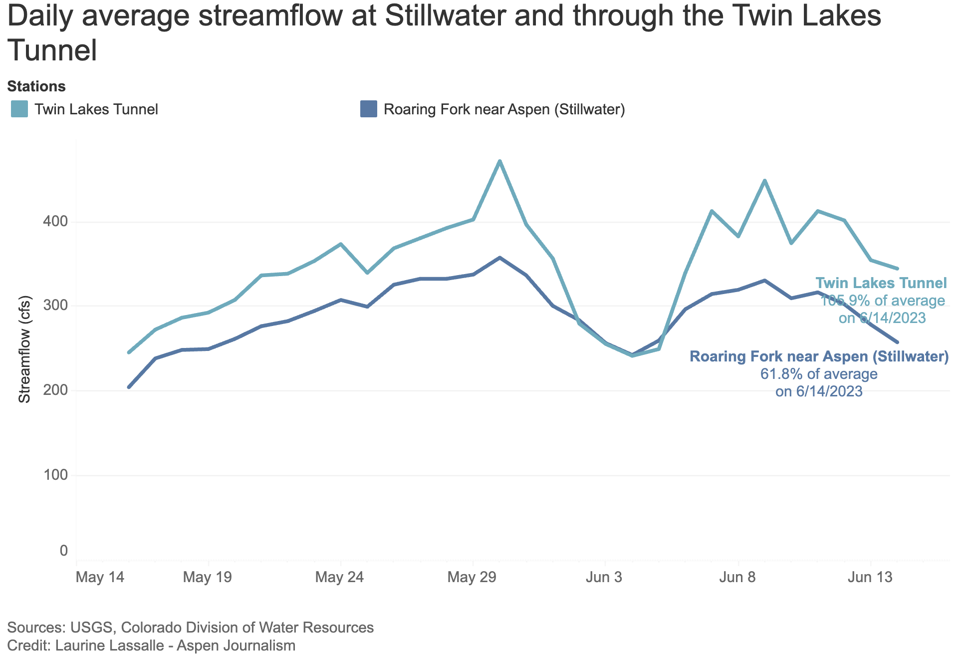
According to the stream gauge just above Aspen at Stillwater, the Roaring Fork was flowing at 257 cfs on Wednesday — about 62% of average — and the Twin Lakes diversion was taking 344 cfs through the tunnel on Wednesday and up to 437 cfs on Thursday. That means the river could be flowing as high as nearly 700 cfs at Stillwater by early next week. That’s still well below the “action stage” for flooding of 1,048 cfs, as defined by the Colorado Basin River Forecast Center.
Interim General Manager of the Twin Lakes Reservoir and Canal Co. Matt Heimerich said the company’s space in Twin Lakes Reservoir is nearing capacity and the Colorado Canal that brings water to farmers in Crowley County is also full. When those two things happen, Twin Lakes is required to shut off the Independence Pass diversion.
“It’s a little bit of a moving target,” Heimerich said. “It’s dependent on the two conditions and they have to happen in a simultaneous fashion.”
Heimerich said they are projecting to reach the storage condition on Monday, June 19, which means they will start to ramp down diversions on Sunday, June 18. Diversions will resume once water levels drop in the Arkansas River basin and the Colorado Canal can no longer be filled with water on the east side of the divide.
Transmountain Diversion system
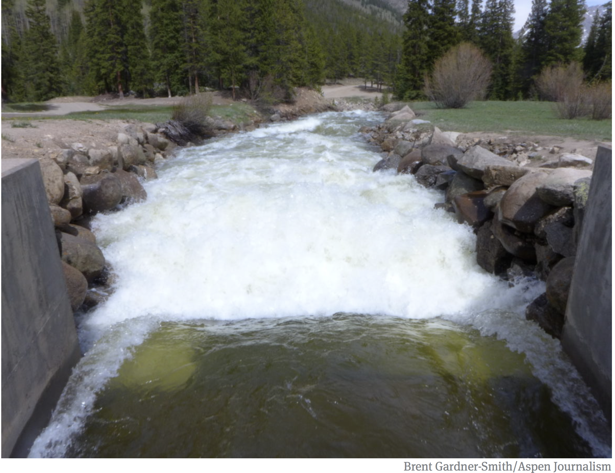
The Independence Pass Transmountain Diversion System, operated by Twin Lakes Reservoir and Canal Co., collects runoff from 45 square miles of high alpine terrain, including the New York, Brooklyn, Tabor, Lincoln, Grizzly and Lost Man creek drainages, dumping those flows into Grizzly Reservoir, which can hold 570 acre-feet of water.
From there the water runs through the 4-mile-long Twin Lakes Tunnel under the Continental Divide and into Lake Creek, a tributary of the Arkansas River. Twelve miles later the water arrives at the Twin Lakes Reservoir where it is stored before being sent down the Arkansas River, eventually reaching Front Range cities and Eastern Plains farms with the help of a network of pipelines, pumps and canals.
Four municipalities own 95% of the shares of Twin Lakes water: Colorado Springs Utilities owns 55%; the Board of Water Works of Pueblo has 23%; Pueblo West Metropolitan District owns 12% and the City of Aurora has 5%. It’s Colorado Springs’ largest source of Western Slope water and represents about 21% of the utility’s total water supply.

Because of cool temperatures and cloudy skies, this year’s runoff has been slow and steady so far.
“That’s definitely what we’ve been seeing: a fairly long, extended period of high flows versus a single, well-defined peak,” said Cody Moser, a senior hydrologist with CBRFC.
Prior to the added flows, the Fork near Aspen peaked on May 30 at 417 cfs.
Christina Medved, director of community outreach at the Basalt-based Roaring Fork Conservancy, said the additional flow is great news for the river ecosystem. The group has a planned educational float next week through the North Star Nature Preserve upstream of Aspen, which will look more like the true wetland that it is because of the extra water. Water managers and river lovers in the Roaring Fork Valley like when the Twin Lakes diversion pauses — which often happens in late summer when senior water users in the Grand Valley place the Cameo call, shutting off upstream junior users — because it means more water flowing through local communities.
“What could be exciting is for people to go look at the river,” Medved said. “This is as close as we get to seeing it as if there wasn’t a transbasin diversion.”
Even though officials don’t expect flooding in the Aspen area, they are still urging caution, especially for kids and pets, around high-flowing rivers.
