

Click the link to read the article on the NOAA website:
Key Points:
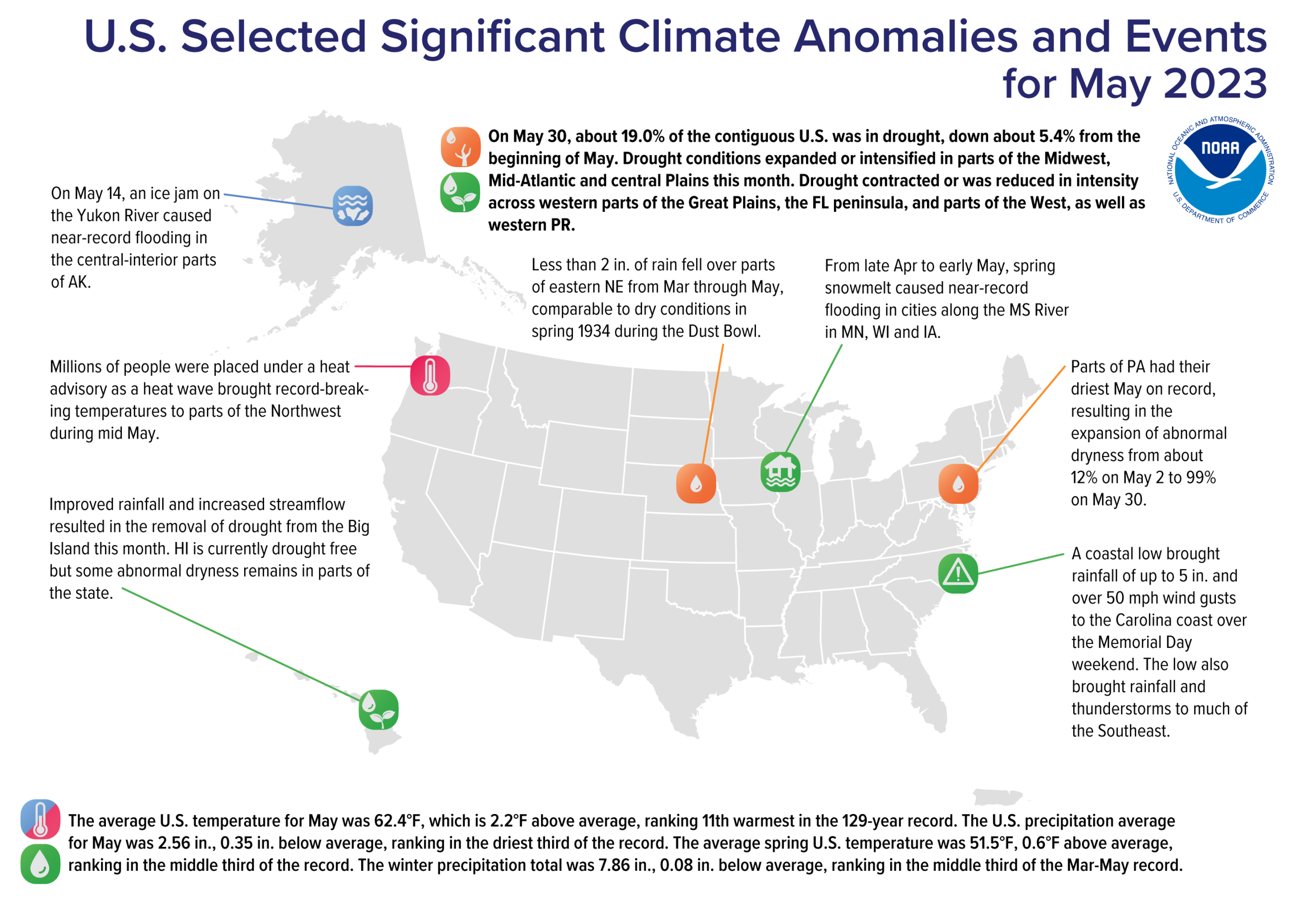
- Millions of people were placed under heat advisories as a heat wave brought record-breaking temperatures to parts of the Northwest during mid May. Temperatures reached 89°F in Seattle and 92°F in Portland, setting daily records in both cities.
- Over the spring season, less than two inches of rain fell over parts of eastern Nebraska, resulting in the driest conditions for the region since 1934 during the Dust Bowl.
- Nine billion-dollar weather and climate disasters have been confirmed this year. These disasters consisted of seven severe storm events, one winter storm and one flooding event.
- Drought coverage in the contiguous U.S. has dropped nearly 44% over the last seven months, from 63% on November 1, 2022 to 19% on May 30, 2023—the fastest reduction in drought coverage since the start of the U.S. Drought Monitor (since 2000), and the smallest drought footprint since May 26, 2020.
- Much of the eastern U.S. had a warm start to 2023. For the January–May period, 28 states experienced a top-10 warmest event and Florida was record warm.
- In May, the average temperature was 11th warmest and precipitation ranked in the driest third of the historical record.
Other Highlights:
Temperature
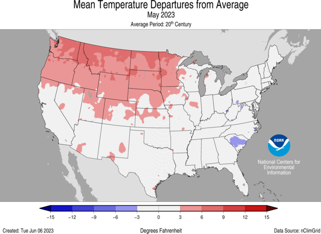
The average temperature of the contiguous U.S. in May was 62.4°F, 2.2°F above average, ranking 11th warmest in the 129-year record. Generally, May temperatures were below average along the East Coast, from Vermont to northern Florida. Temperatures were above average across much of the West to the Mississippi River Valley and in the Florida Peninsula. Washington ranked warmest on record for May while Oregon, Idaho and Montana each ranked fifth warmest on record. Four additional states ranked among their top-10 warmest May on record. Conversely, South Carolina ranked 10th coldest on record for the month.
The Alaska statewide May temperature was 39.8°F, 2.0°F above the long-term average, ranking in the middle third of the 99-year period of record for the state. Temperatures were above average across much of the north, east and Panhandle, with near-normal temperatures observed across much of the western and southern portions of the state, including the Aleutians, during the month.
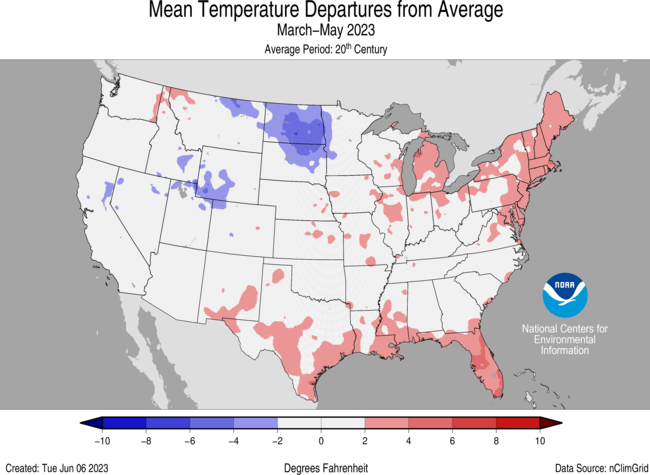
The meteorological spring (March–May) average temperature for the contiguous U.S. was 51.5°F, 0.6°F above average, ranking in the middle third of the record. Temperatures were above average from the southern Plains and Great Lakes to the East Coast and in parts of the Northwest. Temperatures were below average from parts of the West Coast to the northern Plains. Florida ranked fourth warmest while Massachusetts ranked 10th warmest on record for this spring season.
The Alaska spring temperature was 23.3°F, 0.7°F below the long-term average, ranking in the coldest third of the record for the state. Temperatures were below average across much of interior Alaska and in parts of the west, southwest and Panhandle, while parts of the North Slope and Aleutians saw above average spring temperatures.
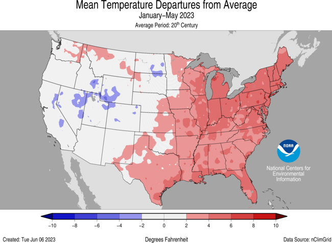
For the January–May period, the average contiguous U.S. temperature was 45.2°F, 1.9°F above average, ranking 18th warmest on record for this period. Temperatures were above average across much of the eastern U.S. and parts of the Northwest, with near- to below-average temperatures from the northern Plains to the West Coast. Florida ranked warmest on record while Massachusetts, Rhode Island, Connecticut, New Jersey, Delaware and Maryland each had their second warmest January–May period. An additional 22 states had a top-10 warmest year-to-date period. No state experienced a top-10 coldest event for this five-month period.
The Alaska January–May temperature was 17.4°F, 1.6°F above the long-term average, ranking in the middle third of the historical record for the state. Much of the state was near-normal for the five-month period while temperatures were above average across much of the North Slope and in parts of the southeast, Kodiak Island and the Aleutians.
Precipitation
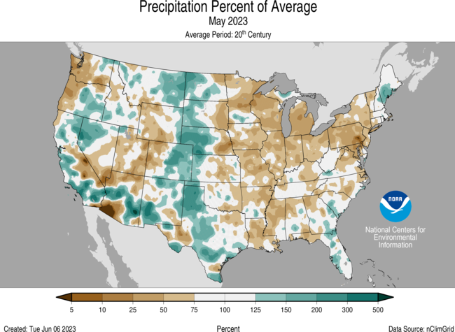
May precipitation for the contiguous U.S. was 2.56 inches, 0.35 inch below average, ranking in the driest third of the historical record. Precipitation was above average across much of the western Plains and West and in parts of the Southeast and New England. Precipitation was below average from the Mississippi River Valley to the Mid-Atlantic and southern New England, and in parts of the Northwest and central Rockies. Wisconsin ranked fourth driest while Pennsylvania ranked fifth, Maryland eighth and Michigan ninth driest on record.No state experienced a top-10 wettest event for this month.
Across the state of Alaska, the average monthly precipitation was 2.98 inches, making last month the fourth-wettest May in the 99-year record. Conditions were wetter than average across most of the state while parts of the Southeast were record wettest. Near-average precipitation was observed in parts of the Aleutians and the Panhandle during the month.
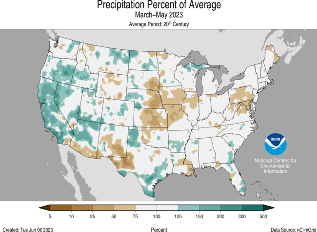
The U.S. spring precipitation total was 7.86 inches, 0.08 inch below average, ranking in the middle third of the March–May record. Precipitation was above average from the West Coast to the Rocky Mountains, and in parts of the western Plains, northern Great Lakes and Southeast. Spring precipitation was below average from the central Plains to the Mid-Atlantic and in parts of the central and northern Rockies, as well as Maine. Pennsylvania and Maryland each ranked ninth driest while Kansas ranked 13th driest on record for the spring season.
For spring season precipitation, Alaska ranked in the middle third of the record with wetter-than-average conditions observed across most of the state. Precipitation was near average in parts of south-central Alaska and along the Gulf of Alaska coast.
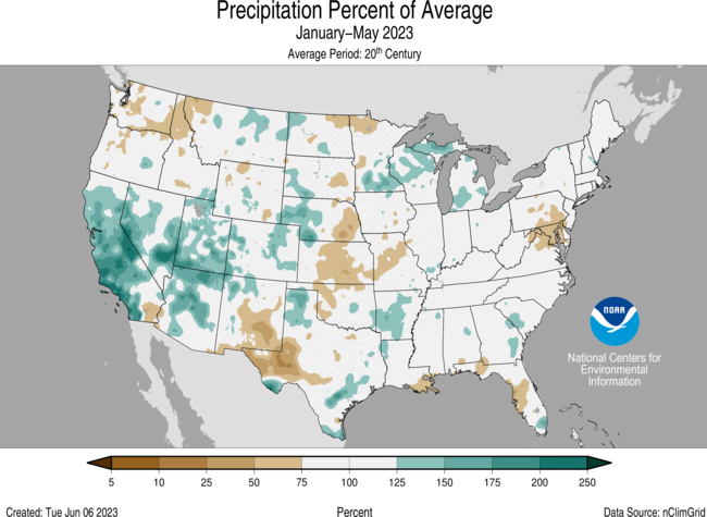
The January–May precipitation total for the contiguous U.S. was 12.82 inches, 0.43 inch above average, ranking in the middle third of the 129-year record. Precipitation was above average across much of California and the Southwest, and in parts of the southern Mississippi Valley, Southeast, northern Plains and Great Lakes. Utah and Nevada ranked 11th and 13th wettest on record, respectively. Conversely, precipitation was below average across much of the Mid-Atlantic and in parts of the Northwest and central Plains during the January–May period. Maryland ranked fifth driest while Pennsylvania ranked 12th driest on record.
The January–May precipitation ranked in the wettest third of the 99-year record for Alaska, with above-average precipitation observed across much of the eastern Interior, North Slope, West Coast and in parts of the Panhandle. The central Interior and parts of the Southwest and Southeast were near average while south central Alaska and parts of the Aleutians experienced below-average precipitation during this period.
Billion-Dollar Disasters
There have been nine confirmed weather and climate disaster events, each with losses exceeding $1 billion this year. These disasters consisted of seven severe storm events, one winter storm and one flooding event. The total cost of these events exceeds $23 billion, and they have resulted in 99 direct and indirect fatalities.
The U.S. has sustained 357 separate weather and climate disasters since 1980 where overall damages/costs reached or exceeded $1 billion (including CPI adjustment to 2023). The total cost of these 357 events exceeds $2.540 trillion.
Other Notable Events
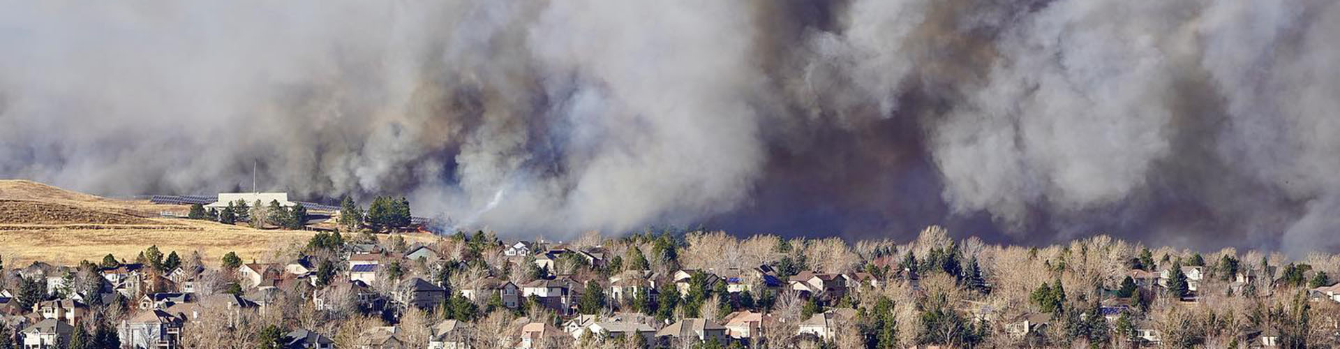
Several notable weather systems produced severe thunderstorms and tornadoes that impacted portions of the U.S. in May.
- On May 7, a line of severe thunderstorms moved into southern Indiana and northern Kentucky. A total of six tornadoes was confirmed by the National Weather Service, five of which occurred within a 15-minute span.
- A tornado outbreak occurred across areas of central Oklahoma on May 11. The National Weather Service confirmed a total of nine tornadoes, which snapped utility poles and damaged homes.
- On May 12, severe thunderstorms produced several tornadoes, up to grapefruit-sized hail and flooding in parts of Nebraska. A total of 19 tornadoes, including three rated as EF-2, was confirmed by the National Weather Service.
During late April and early May, spring melting of record winter snowfall caused the Mississippi River to crest, resulting in near-record flooding in cities along the Mississippi River in Minnesota, Wisconsin and Iowa.
A coastal low brought rainfall of up to five inches and over 50 mph wind gusts to the Carolina coast over the Memorial Day weekend. The low also brought rainfall and thunderstorms to much of the Southeast.
Drought
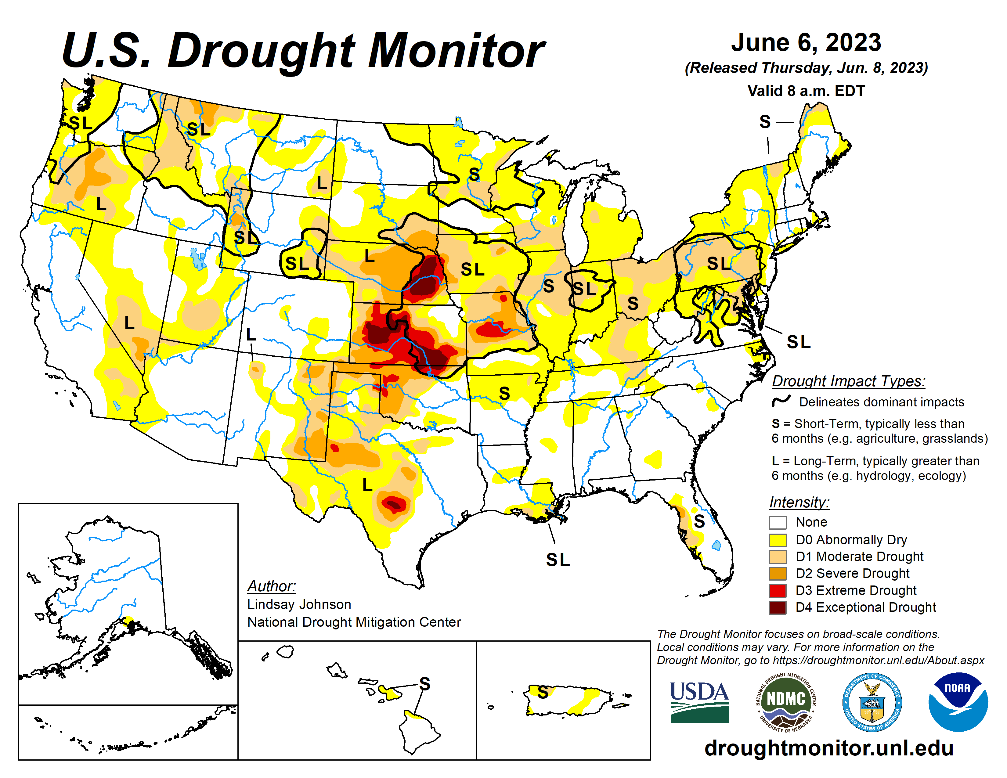
According to the May 30 U.S. Drought Monitor report, about 19.0% of the contiguous U.S. was in drought, down about 5.4% from the beginning of May. Moderate to exceptional drought was widespread across much of the Great Plains, with moderate to extreme drought in parts of central to west Texas. Moderate to severe drought was present in parts of the Northwest, northern Rockies, Southwest and Florida as well as moderate drought in parts of the Mid-Atlantic and Puerto Rico.
Drought or abnormally dry conditions expanded or intensified in parts of the Midwest, Mid-Atlantic and central Plains this month. Drought contracted or was reduced in intensity across western parts of the Great Plains, the Florida peninsula, parts of the West and in western Puerto Rico.
Monthly Outlook
According to the May 31 One-Month Outlook from the Climate Prediction Center, areas from the Northwest to the Ohio River Valley and into the Northeast, along the Gulf Coast and from northern Alaska to the Panhandle favor above-normal monthly average temperatures in June, with the greatest odds in Washington and parts of the northern Plains. The best chances for below-normal temperatures are forecast from southern California to the central Rockies and in parts of southwest Alaska. Much of the Northwest to southern Plains, as well as parts of Florida and southwest Alaska, are favored to see above-normal monthly total precipitation.Below-normal precipitation is most likely to occur from the northern Plains to the Great Lakes and in the interior parts of central and eastern Alaska. Drought improvement or removal is forecast across much of the Plains and portions of the northern Rockies and Florida, while persistence is more likely in portions of the Northwest, Southwest and parts of the central Plains and northwest Puerto Rico. Drought development is likely from the middle Mississippi Valley to parts of the Northeast and in parts of Hawaii.
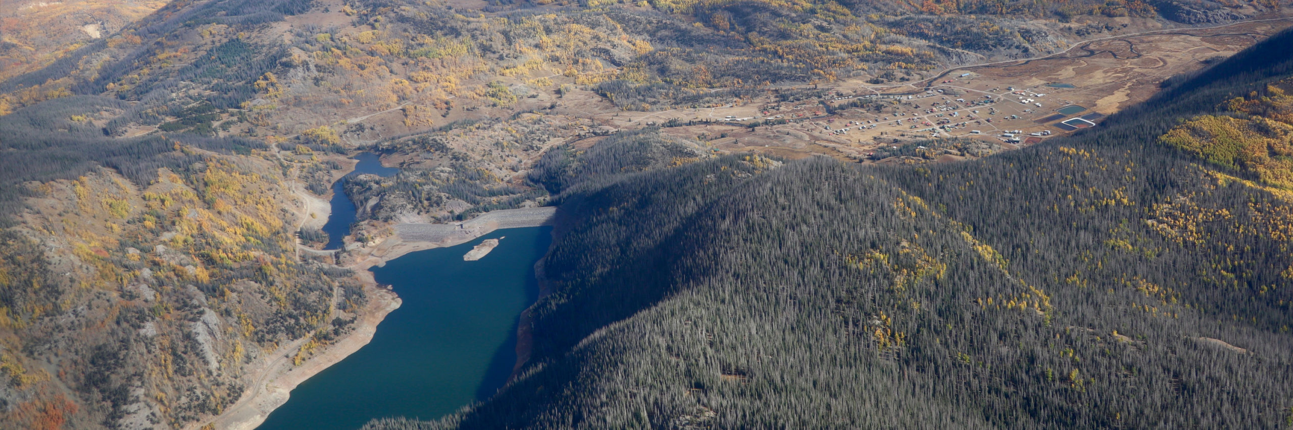
According to the One-Month Outlook issued on June 1 from the National Interagency Fire Center, portions of the Northwest, northern Great Lakes and eastern Alaska have above-normal significant wildland fire potential during June, while portions of California and the Southwest are expected to have below-normal potential for the month.
This monthly summary from NOAA’s National Centers for Environmental Information is part of the suite of climate services NOAA provides to government, business, academia and the public to support informed decision-making. For more detailed climate information, check out our comprehensive May 2023 U.S. Climate Report scheduled for release on June 13, 2023. For additional information on the statistics provided here, visit the Climate at a Glance and National Maps webpages.


