#ClimateChange compounding inequalities faced by women in agriculture, UN Food & Agriculture Organization says — Carbon Brief

PAKISTAN – A woman carries her daughter as she arrives to work at a vegetable field. Photo credit: Aamir Qureshi/FAO

Click the link to read the article on the Carbon Brief website (Yanine Quiroz):

Women working in agriculture “tend to do so under highly unfavourable conditions” – often in the face of “climate-induced weather shocks and in situations of conflict”, a new report from the UN Food and Agriculture Organization (FAO) concludes. 

The report provides insight into women’s participation in agrifood systems at every step of the chain, from production to consumption. It comes more than a decade after the last publication of its kind by the FAO.

Agriculture and food systems are a significant employer for women globally – and are a more critical source of livelihood for women than for men, the report says.

However, women face inequalities that constrain their full participation in the sector, it warns. They are likely to work under worse conditions than men, taking informal, part-time, labour-intensive and low-skilled jobs at higher rates, and earning 82 cents for every dollar men earn. 

Climate change and the Covid-19 pandemic have also affected women’s productivity in agrifood systems, the report notes. For example, women are less likely than men to see their work demands decrease during periods of extreme heat.

Addressing inequalities and empowering women would improve their well-being and that of their households, the report says. Doing so would also reduce hunger, increase incomes and strengthen resilience. 

Despite this, the authors warn that few national policies have specific targets to address women’s inequalities in agrifood systems. And while national climate pledges under the Paris Agreement have seen a “modest improvement” on gender equality and women’s rights over the past decade, inclusion of these issues is “often superficial”.

Here, Carbon Brief summarises the key messages from the FAO’s landmark report. 

Women’s roles

The new report, The Status of Women in Agrifood Systems, is “much broader” than the FAO’s previous work on gender, says Dr Lauren Phillips, the deputy director of the FAO’s inclusive rural transformation and gender equality division. The 2011 report focused on women in agriculture alone. 

Phillips, one of the lead authors of the new report, tells Carbon Brief that, in contrast, the new iteration covers all agrifood systems and all phases of production, with data disaggregated by gender. The new report also delves into the importance of women’s empowerment in these sectors.

As defined by the FAO, “agrifood systems” refers to the entire range of actors and their activities linked to the production and consumption of both food and non-food agricultural products. This includes products derived from agriculture, livestock, forestry, fisheries and aquaculture. 

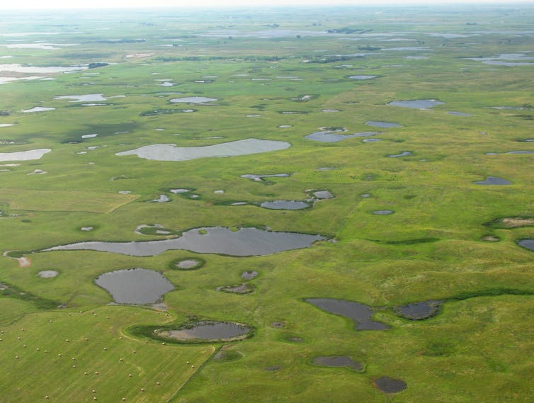
Overall, the world produces around 11bn tonnes of food annually, and about 4 billion people live in households that depend on this sector for their livelihood.

Such systems are constantly changing and are impacted by economic, social and environmental factors, including – increasingly – climate change. 

The new report says that women play a range of roles in agrifood systems, from farmers to wage workers and entrepreneurs. Women also often carry out unpaid activities, such as subsistence farming to feed their families. 

Globally, men are more commonly employed in agrifood systems, with 38% of working men employed in such roles, compared to 36% of working women. 

But in sub-Saharan Africa and in many south-east Asian countries, such as Cambodia, Vietnam and the Lao People’s Democratic Republic, women make up half of the agricultural labour force. 

As the chart below illustrated, globally, women (purple) make up 38% of agrifood system workers, while men (orange) make up the other 62%. 

The share of women (purple) and men (orange) in agrifood system employment, broken down by regions and types of activity: agricultural (top bars) or off-farm (bottom bars). Overall, women make up almost 40% of all workers in agrifood systems, but this percentage varies widely across regions. Source: FAO (2023)

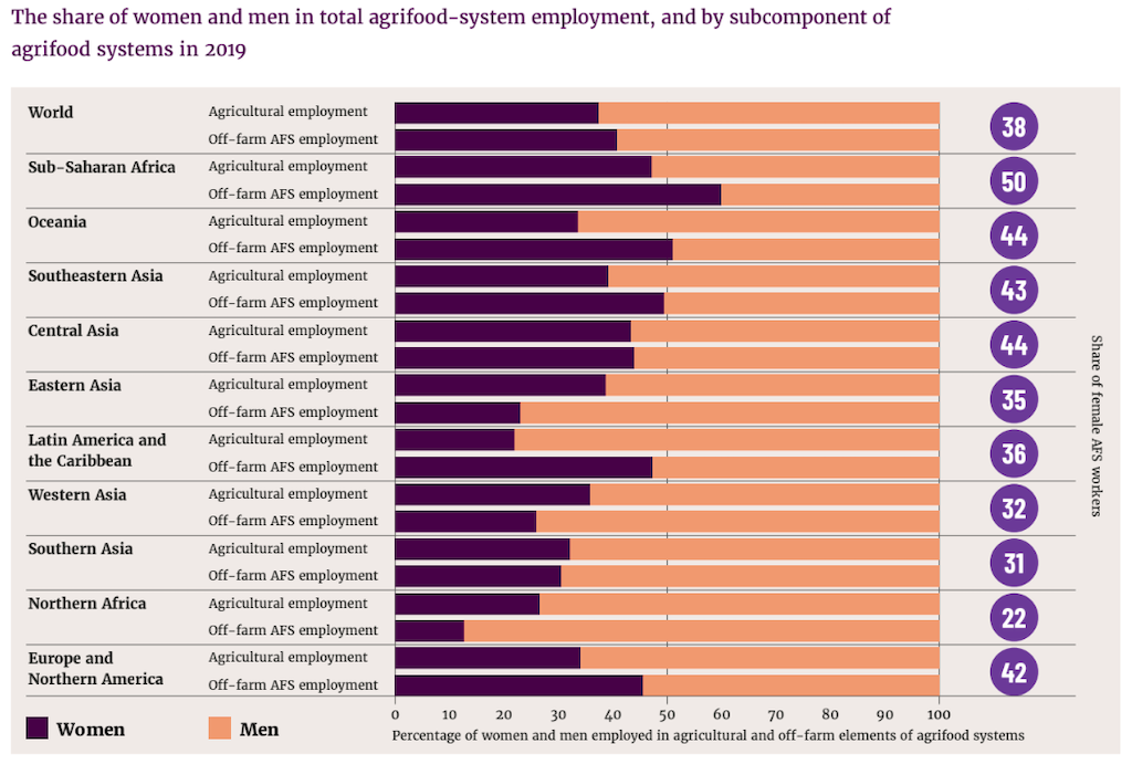
Even within a single region, countries vary in their share of women in the agrifood systems labour force. Although women make up only 36% of agricultural workers in Latin America and the Caribbean as a whole, they are 54% of such workers in Bolivia.

Agrifood systems provide many jobs for women and men alike, but both have observed a decline of nearly 10 percentage points in agrifood system employment since 2005. This decrease is due to a reduction in employment in the primary agricultural sector, while employment in off-farm activities – such as food storage, transportation, distribution, marketing or consumption – has remained generally steady.

Where women’s involvement in agriculture has increased, this is sometimes taking place “where the economic viability of agriculture is diminishing because of climate change and other stressors”, the report notes.

One of the report’s main findings is that agrifood systems are a more significant source of livelihood for women than for men in many countries. 

For example, in southern Asia, 71% of women work in the agrifood sector, compared to 47% of working men. However, there are much fewer women in the labour force in general in that region.

The report also describes the range of agrifood activities in which women are involved.

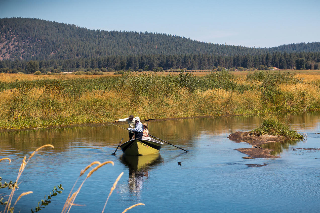
Women make up 50% of workers in the aquatic sector – aquaculture and fisheries – and 40% in small fisheries, which includes traditional fishing to obtain small amounts of food and is often carried out by families. However, they hold only 15% of the full-time positions in these primary sectors, while holding 71% of the part-time jobs in processing, making their employment “more precarious”, the report says.

Moreover, it adds, women “tend to trade in medium-to-low-value species and in smaller volumes and are frequently excluded from the most lucrative value chains”. 

A similar situation prevails in livestock production. Although there is a lack of specific data on women’s share in the livestock industry, “women continue to be disadvantaged in livestock ownership”, the report says.

For example, men traditionally own the most profitable livestock species, such as cattle, camels and buffalo. Conversely, women typically control less-profitable livestock breeds such as poultry and small ruminants.

The report notes that “livestock ownership is important for reducing poverty among women”, adding:

“It also helps to increase household resilience to climate change and associated shocks. Women who have access to and control over livestock have a higher capacity to improve the health, education and food security of their households.”

Remaining barriers 

Women face several barriers that jeopardise their full participation in agrifood systems, the report explains. 

Besides having worse working conditions than men, women deal with high demands of unpaid care, as they often also spend time cooking, cleaning and caring for their families, as well as collecting water in rural areas. All of this “contributes to inequalities in labour market participation” and limits “their opportunities for education and employment”, the report says. 

As a result, women in agriculture have lower wages than men: they earn 82 cents for every dollar men earn. 

Furthermore, women in the world’s lowest-income countries are more likely to work in agrifood systems than women in higher-income countries. They often work in family agriculture and under extreme climate conditions, and are less likely to be entrepreneurs. 

That has led to a crop yield “gap” of 24% between female- and male-managed farms of the same size, according to the FAO report.

Limited access to essential resources for agrifood systems, such as land tenure, services, finance and digital technology, is another barrier that women face. Women also have less access to improved seeds, fertilisers and farming equipment than men, the report says.

The number of men who own agricultural lands is twice that of women. However, women have increased their land ownership in 10 countries over the last decade, primarily in sub-Saharan Africa and southern Asia.

The report highlights that “discriminatory social norms and rules” are significant drivers of gender inequality, adding that these are “slow to change”. Examples of such norms include the expectation in many places that women and girls will perform unpaid domestic labour, which limits the amount of work they can do outside the home.

The report says that the Covid-19 pandemic had a “greater negative impact on women’s livelihoods in agrifood systems than they do on men’s”. During the pandemic, women suffered the most from food insecurity and lost more jobs (22%) than men (2%). 

Similarly, climate change and extreme weather events disproportionately affect women. Studies have also shown that addressing gender-based inequalities is important for climate resilience.

Climate change also affects women’s capacity to adapt. For example, discriminatory norms can reduce women’s access to climate information, which is crucial to understand how to adapt to global warming.

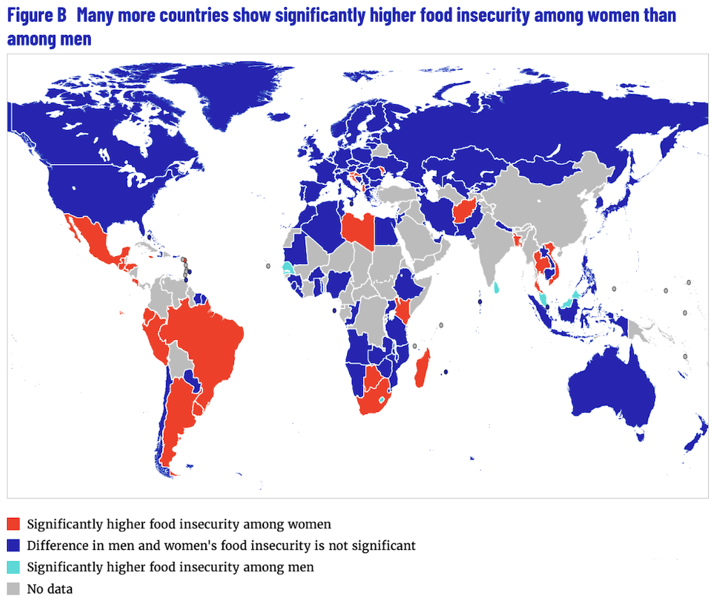
At least 939 million women aged 15 or older experienced moderate to severe food insecurity in 2021, compared with 813 million men, the report says. The map below displays the countries with higher food insecurity among women (red) and men (turquoise), with blue indicating countries that do not have significantly different rates of food insecurity between men and women. Countries with higher levels of food insecurity for women are concentrated in Latin America and the Caribbean, Africa and south-east Asia. 

Countries with higher food insecurity among women (red) and men (turquoise). Blue indicates countries where food insecurity does not significantly vary between women and men. Source: FAO (2023)

The report also notes that women in rural areas, “who have limited resilience capacity and consequently restricted options to respond to changes in climate, often have to resort to short-term coping strategies at the expense of their long-term resilience to climate shocks and stressors”. In India, for example, “women often resort to decreasing the number and size of meals they consume during droughts, with negative effects to their overall health”.

Empowering women

The report offers a snapshot of how social norms are changing over time and how they create inequalities in agrifood systems, but it also provides an overview of the policies that have been successful in either closing gender gaps or empowering women, Phillips says.

It highlights that tackling gender inequalities and empowering women in agrifood systems will reduce hunger and poverty, boost economies and strengthen resilience to pandemics and climate change. It says:

“Reducing their barriers to their participation and changing the norms and rules that constrain it has great benefits for women’s well-being and for wider society as a whole.” 

For example, closing the gender gap in farm productivity and the wage gap in agrifood systems would boost the global economy – increasing global gross domestic product by 1% (nearly $1tn) – and alleviate food insecurity for 45 million people. 

The report also emphasises that projects empowering women bring higher benefits than those that only mainstream gender.

Mainstreaming gender means integrating both women’s and men’s concerns into the planning, development and implementation of a project, so that everyone can benefit equally.

Women’s empowerment, on the other hand, means providing women with the capabilities, rights and resources to make their own decisions, thus transforming discriminatory social norms that perpetuate inequalities. For example, Phillips says, a project might ensure that women have appropriate mobility so they can easily travel from their homes to their work. 

The authors estimate that if half of the small-scale producers benefited from projects that support women’s empowerment, it would increase the income of 58 million people and the resilience of 235 million people worldwide.

However, the world is not yet on that path. The report notes that while “more than half of bilateral finance for agriculture and rural development already mainstreams gender, only 6% treats gender as fundamental”. 

It cites several international agreements that address gender equality, such as the Sustainable Development Goals, which call for gender equality and empowerment for all women by 2030.

Gender-transformative actions are considered a solution to change discriminatory norms that affect women in agrifood systems. The report observes that “such approaches are cost-effective and have high returns”. 

For example, interventions that improve women’s productivity are more successful when they alleviate women’s unpaid work demands, such as by providing access to childcare. 

Such gender-transformative approaches can make a change at the local level, but they need to be deployed at a much larger scale in order to change social norms more broadly, Phillips tells Carbon Brief. She adds:

“There’s been positive change so far that more and more countries acknowledge women in their national policy frameworks around agriculture, but not many of them are necessarily proposing specific and concrete actions.”

This is reflected in climate policies, the report says, noting a “modest improvement” over the past decade “in the degree and way in which gender equality and women’s rights issues are introduced in climate-related policy”. 

For example, the report cites a 2021 review of national climate pledges under the Paris Agreement, where the percentage of reviewed pledges with mentions of women and/or gender increased from 40% in 2016 to 78% in 2021. The report says that “agriculture was the sector with the greatest degree of integration of gender”.

However, despite some positive changes, “national agricultural and environmental policies that mention gender-related vulnerabilities to climate change often still do not include policy measures or strategies to address them during implementation”, it says.

Phillips notes that some countries of sub-Saharan Africa and Latin America have increased their budgets for implementing policies addressing gender and inequality. Sub-Saharan Africa is the region with the highest number of such policies. She says:

“If policies were already responsive, and included women in policy processes, they’re much more likely to help women withstand shocks and to be resilient to shocks when they arrive.”

However, the report warns that “evidence from Central America, east Africa and Nepal indicates that integration of gender equality and women’s rights issues in national climate and agriculture policy is often superficial, with passing mention of ‘gender’, often merely acknowledging its relation to climate change”. 

#NewMexico Governor Lujan Grisham calls out U.S. Supreme Court #WOTUS Decision as ‘devastating’ to New Mexico’s waters — The Carlsbad Current Argus

Birds and water at Bosque de Apache New Mexico November 9, 2022. Photo credit: Abby Burk

Click the link to read the article on the Carlsbad Current Argus website (Adrian Hedden). Here’s an excerpt:

New Mexico’s state leaders criticized the Republican-led U.S. Supreme Court for a recent decision that could limit protections for waterways throughout the arid state. The Supreme Court issued a judgement on May 25 in Sackett vs. the U.S. EPA, ultimately finding the Clean Water Act (CWA) only applied to wetlands that are directly connected to permanent bodies of water…The opinion was written by Justice Samuel Alito, with the other members issuing concurring opinions in the case.

“In sum, we hold that the CWA extends to only those ‘wetlands with a continuous surface connection to bodies that are waters of the United States in their own right, so that they are ‘indistinguishable’ from those waters,” read Alito’s opinion. “This holding compels reversal here. The wetlands on the Sacketts’ property are distinguishable from any possibly covered waters.”

But New Mexico Gov. Michelle Lujan Grisham contended the decision weakened the Clean Water Act and could put many of New Mexico’s fragmented rivers and streams at risk. In a statement following the verdict, Lujan Grisham said she was “appalled” and contended the ruling would leave 90 percent of New Mexico’s waters without federal protection from development. Lujan Grisham said her administration planned to study how state law could be used to fill any “regulatory gaps” created by the Supreme Court ruling to protect the state’s limited water resources.

Local rescuers busy with high #water — The #GrandJunction Daily Sentinel #GunnisonRiver #ColoradoRiver #COriver

Click the link to read the article on The Grand Junction Daily Sentinel website (Sam Klomhaus). Here’s an excerpt:

The Grand Junction Fire Department has conducted five river rescues since May 1, according to spokesperson Ellis Thompson-Ellis. Training for river rescues has been a priority for the department of late, as people have underestimated the current conditions and their own skill levels. The Colorado River near Palisade was discharging at between 17,000 and 17,500 cubic feet per second, well above the median for this time of year, which is around 8,000 cfs, and the Gunnison River near Grand Junction is discharging at around 13,000 cfs, also well above the median of around 6,500 cfs. Those high waters have closed multiple sections of the Riverfront Trail, and the city of Grand Junction is warning people away from the River Park at Las Colonias.

Colorado River at Los Colonias Park in Grand Junction May 23, 2023.

Navajo Reservoir operations update May 29, 2023 #SanJuanRiver #ColoradoRiver #COriver #aridification

Navajo Reservoir, New Mexico, back in the day.. View looking north toward marina. The Navajo Dam can be seen on the left of the image. By Timthefinn at English Wikipedia – Transferred from en.wikipedia to Commons., Public Domain, https://commons.wikimedia.org/w/index.php?curid=4040102

From email from Reclamation (Susan Novak Behery):

The Bureau of Reclamation is continuing to schedule release changes for the spring peak release from Navajo Reservoir.  

The current release is 4,000 cfs. The next release changes are scheduled to occur as follows: 

Date Time Release 
Tuesday, May 30th 10:00 AM 4,300 cfs 
Wednesday, May 31st  10:00 AM 4,600 cfs 
Thursday, June 1st 10:00 AM 5,000 cfs 

Release changes are made based on river conditions and coordination with federal, state, and local agencies.  

The shape and timing of the hydrograph have been coordinated with the San Juan River Basin Recovery Implementation Program to balance Recovery Program benefits with flood control and operational safety. During spring operations, releases from the Navajo Unit will be made in an attempt to remain at or below the U.S. Army Corps of Engineers safe channel capacity of 5,000 cfs between Navajo Reservoir and the confluence with the Animas River in Farmington, and 12,000 cfs downstream of Farmington.  The release may be changed or reduced if the precipitation forecast shows a risk of exceeding safe channel capacity in the San Juan River. 

Areas in the immediate vicinity of the river channel may be unstable and dangerous. River crossing may change and be impassable as flows increase. Please use extra caution near the river channel and protect or remove any valuable property in these areas. 

Notices will be posted to our website along with the latest release schedule.http://www.usbr.gov/uc/wcao/water/rsvrs/notice/nav_rel.html 

For more information, please see the following resources below:  

Bureau of Reclamation:  

• Susan Behery, Hydrologic Engineer, Reclamation WCAO (sbehery@usbr.gov or 970-385-6560).   

• Navajo Dam website: https://www.usbr.gov/uc/water/crsp/cs/nvd.html  

• Navajo Dam Release Notices: https://www.usbr.gov/uc/wcao/water/rsvrs/notice/nav_rel.html  

• Colorado River Basin Facebook Page: https://www.facebook.com/coloradoriverbasin  

San Juan County, New Mexico, Office of Emergency Management:  

• Website: https://www.sjcoem.net  

• SJOEM River Page: https://www.sjcounty.net/river  

• Facebook Page: https://www.facebook.com/oemsjc  

San Juan County, Utah, Office of Emergency Management:  

• Website: https://sanjuancounty.org/emergency-management  

• San Juan County Facebook Page: https://www.facebook.com/SanJuanUtah/  

Navajo Nation Department of Emergency Management:  

• Website: https://ndem.navajo-nsn.gov/  

• Facebook Page: https://www.facebook.com/nndem2020/  

Volunteers helping survey Rabbit Valley for rare plant — The #GrandJunction Daily Sentinel

Dolores River skeleton plant (Lygodesmia doloresensis). Photo by Peggy Lyon via Colorado Natural Heritage Program

Click the link to read the article on The Grand Junction Daily Sentinel website (Dan West). Here’s an excerpt:

Tucked away in Rabbit Valley, a rare native plant called the Dolores River Skeleton Plant has been spotted. Very little is known about it, but Colorado Canyons Association and the Bureau of Land Management are hoping to learn more with the help of some local volunteers and a smartphone app. On Thursday, June 1, 2023, the Colorado Canyons Association is hosting an event for volunteers to come and gather data on the plant with the help of BLM ecologists. Plant location, population and even what bloom stage the flowers are in are some of the things the volunteers will record, CCA Volunteer and Outreach Coordinator Morgan Rossway said…

“It has such a brief window when it blooms to be able to identify it,” Rossway said. “We’re hoping that we can catch that window and with the help of the BLM ecologists that are going to come to the event they’ll help our volunteers (identify the plant).”

Volunteers will enter the data into the iNaturalist app. The app is a joint initiative of the California Academy of Sciences and the National Geographic Society, which allows users to enter observations of plants into the app and share it with other users. In this case it will be shared with BLM ecologists, rather than the general public…

The CCA is still accepting volunteers to help with the Dolores River Skeleton Plant Survey. If you are interested in taking part you need to register for the event online at coloradocanyonsassociation.org.

The U.S. Supreme Court Just Withdrew Protections from a Huge Portion of the Country’s #Wetlands — Field & Stream

A sunset in Autumn at Priest Lake. By S.hammarlund (talk) – I created this work entirely by myself., Public Domain, https://commons.wikimedia.org/w/index.php?curid=108282741

Click the link to read the article on the Field & Stream website (Travis Hall). Here’s an excerpt:

On May 25, 2023, the Supreme Court of the United States (SCOTUS) issued a ruling that could ultimately rescind federal protections from more than 50 percent of the nation’s wetlands. With its 5-4 ruling in a case known as Sackett v. EPA, SCOTUS declared that the Clean Water Act—a measure long-regarded as the most impactful clean water safeguard ever enacted—no longer applies to isolated wetlands that aren’t visibly connected to larger water bodies by continuous, surface-level flows. According to sportsmen’s groups, the ruling will leave these isolated wetlands unprotected from development, drilling, and other sources of pollution. While the decision will be a boon to the homebuilding and extraction industries, it could have far-reaching and detrimental repercussions for wildlife species that rely on cold, clean water sources—like trout and waterfowl.

“It’s bad news for hunters and anglers,” Alex Funk, Director of Water Resources and Senior Counsel for the Theodore Roosevelt Conservation Partnership (TRCP), tells Field & Stream. “Everything from ducks to cold-water fish species like trout rely on headwater streams and headwater wetlands, like fens, to help maintain water temperatures—those are at risk now.”

[…]

The Clean Water Act’s stated goals were beautifully simple: Make America’s rivers and wetlands “swimmable and fishable” again. For fifty years, throughout the administrations of six different U.S. Presidents, the federal rule worked well. And it reversed some of the country’s most egregious environmental sins. Then, in 2001 and again in 2006, SCOTUS began taking court cases with huge implications for the future of the Clean Water Act. Its rock-solid protections were eroded by unfavorable court decisions, and the clarity that had made the CWA such an effective safeguard for so many years was muddied…

In response to the confusion brought about by these court cases, the Obama-era EPA proposed the so-called Waters of the U.S. Rule—commonly known as WOTUS. This 2015 rule sought to clarify and re-establish lost protections for hundreds of thousands of miles of ephemeral streams and tens of thousands of acres of wetlands. It was widely supported by the vast majority of America’s hunting and angling conservation groups.  But its opponents had immense power in the mining, agribusiness, and development sectors. That lobby’s boisterous campaign to undermine WOTUS was widely successful, and in 2019 President Trump decried the rule as “horrible”, scaling back its protections for ephemeral streams and isolated wetlands once again. Then, when current President Joe Biden took office, his EPA administrator rebuilt WOTUS, restoring its protections to pre-Trump levels. That’s more or less where the rule remained until yesterday…

“The wetlands on the Sackett property are distinguishable from any…waters [that are covered under the CWA],” wrote Justice Samuel Alito, because they aren’t visibly connected to them. Writing for the majority, Alito went on to say that, in order to be eligible for federal protections under the Clean Water Act, a wetland must have a “continuous surface connection with water, making it difficult to determine where the water ends and the wetland begins.”

Creating a balance of water that’s taken from aquifers and water that replenishes aquifers is an important aspect of making sure water will be available when it’s needed. Image from “Getting down to facts: A Visual Guide to Water in the Pinal Active Management Area,” courtesy of Ashley Hullinger and the University of Arizona Water Resources Research Center

“The Court is basically making the assumption that water only flows on the surface,” Trout Unlimited President and CEO Chris Wood tells F&S. “They’re making the assumption that there’s no such thing as groundwater, no such thing as sub-surface flow. It totally flies in the face of the scientific reality, and it’s a dangerous reading of the Clean Water Act.”

[…]

According to TRCP’s Funk, the onus will now fall on individual states to enact whatever clean water protections they see fit. “Most states don’t have the resources to set up clean water programs and enforce those safeguards,” says Funk. “The whole model of the Clean Water Act was that the feds would provide that cooperative base level of protection for the states. With this ruling, that base just dropped considerably.”

Fear, frustration and fatigue: How a deal to save the #ColoradoRiver was struck — The Washington Post #COriver #aridification

The Colorado River from Navajo Bridge below Lee’s Ferry and Glen Canyon Dam. The proposed Marble Canyon Dam would have been just downstream from here. Jonathan P. Thompson photo.

Click the link to read the article on The Washington Post website (Joshua Partlow). Here’s an excerpt:

When a deal to protect the Colorado River’s water supply finally came together after a year of contentious negotiations and a marathon weekend of last-minute haggling by phone and video calls that ran well past midnight, whatever sense of achievement the participants felt seemed outweighed by relief and fatigue…Within hours, Arizona’s negotiator stressed at a news conference that the deal was simply “an agreement to submit a proposal.” The four northern states along the river signed off on further study of the plan but would concede little else. The negotiations wrapped up with a call to immediately start another multi-year round of talks…

The problems with the negotiations arose partly from the size of the task. The amount of water that the administration was asking states to cut from their farms and cities had never been tried…

West snowpack basin-filled map April 2, 2023 via the NRCS.

In the end, a record-breaking deluge of snow and rain this winter, and a mountain of federal dollars, opened a path to consensus and avoided, at least for now, a battle in the courts…

Camille Calimlim Touton being sworn in as Reclamation’s Commissioner by Secretary Deb Haaland.

Negotiating teams kept meeting throughout the winter, as a barrage of atmospheric rivers pummeled the California coast and snows piled up in the Sierra Nevada and the Rocky Mountains, promising a big runoff year into reservoirs. On Jan. 26, they gathered at Woolley’s Classic Suites, a hotel near the Denver airport. Interior had asked for proposals on potential cuts by the following week. Six of the states were coalescing around a plan that would assign cuts based on evaporation of the river, an approach that would hit California particularly hard. California negotiators were caught off guard that lawyers and technical staff from the other states had arrived early and were huddling at the hotel, already writing proposals…

That month, Beaudreau held separate conference calls with Upper and Lower Basin officials to clarify the lines of command. Lower Basin officials related that the turmoil and strife was not helpful, and they wanted clear direction from Interior. Beaudreau informed state officials that he would be in charge, along with Touton, in the months ahead. Trujillo, the assistant secretary, was taken off the Colorado River negotiations.

At last, states reach a #ColoradoRiver deal: Pay farmers not to farm — Grist #COriver #aridification

A field of produce destined for grocery stores is irrigated near Yuma, Ariz., a few days before Christmas 2015. Photo/Allen Best – See more at: http://mountaintownnews.net/2016/02/09/drying-out-of-the-american-southwest/#sthash.7xXVYcLv.dpuf

Click the link to read the article on the Grist website (Jake Bittle):

After a year of intense negotiations, the states along the Colorado River have reached a deal to solve one of the most complex water crises in U.S. history. The solution to this byzantine conundrum is deceptive in its simplicity: Pay farmers — who collectively use 80 percent of Colorado River deliveries — to give up their water.

Representatives from Arizona, Nevada, and California announced on Monday that they had agreed to reduce their states’ collective water usage by more than 3 million acre-feet over the next three years. That equals around a trillion gallons, or roughly 13 percent of the states’ total water usage. Under the terms of the deal, cities and irrigation districts in these so-called Lower Basin states will receive around $1.2 billion from the Biden administration’s Inflation Reduction Act, or IRA, in exchange for using less water. Most of the reductions are likely to come from farming operations. 

Many had anticipated a more painful resolution to the crisis. Rather than taking mandatory cuts and losing out on billions of dollars from crop sales, irrigators in the Southwest will get millions of dollars to reduce their water usage for just three years — and will cut their usage by less than half of what federal officials demanded last year. 

This rosy outcome is only possible because of a wet winter that blanketed the river basin with snow and stabilized water levels in its two main reservoirs, Lake Powell and Lake Mead. Thanks to the ample runoff, the states could lower their target enough that the federal government could afford to compensate them for almost all of it. 

his deal also resolves a key dispute between Arizona and California, the two largest water users on the river, which have clashed over how to respond to the water shortage. California has argued that Arizona should take the most cuts as the most junior user on the river, while Arizona argued that the cuts should be spread more evenly between all the states. The disagreement caused negotiations to drag out for months, and it’s only thanks to the payout from the federal government that they reached an accord.

These compensated cuts are larger than anything the river states have ever implemented before, but they are temporary, a Band-Aid for a crisis that is not going away any time soon. When the three-year agreement expires in 2026, the states will have to come back to the table again and address the elephant in the room: If water use is growing, and the river’s size is shrinking, some people are going to have to make do with less — not temporarily, but for good. 

“This is a step in the right direction but a temporary solution,” said Dave White, a professor at Arizona State University who studies sustainability policy. “This deal does not address the long-term water sustainability challenges in the region.”

The basic blueprint of the deal is not new. Federal and state agencies in the Colorado River basin have tried to pay farmers to use less water before, but they have had difficulty scaling up these compensation measures. That’s in part because many farmers view the measures as an affront to their industry, even when they’re compensated. When a group of states in the river’s Upper Basin relaunched a dormant conservation program earlier this year, offering farmers money to leave their fields unplanted, just 88 water users across four states ended up participating. 

The other issue is that conserving water is expensive. In order to convince farmers to plant fewer acres, officials need to give them more money per acre-foot of water than they would have made from selling crops on a given field. In California’s Imperial Valley, the “salad bowl” region that grows almost all the nation’s winter vegetables, irrigation officials have paid growers to invest in technology that makes their farms more efficient. But farmers in the valley have balked at the idea of taking money to leave their fields unplanted, especially as vegetable prices have remained high. 

“Water is a valuable asset, and I think people are nervous about parting with it, because it kind of suggests that you don’t really need it after all,” said George Frisvold, an extension specialist at the University of Arizona who studies agricultural policy. “I think there’s real concern that this is voluntary now, but it could come back and bite you.”

The Biden administration has resolved those issues for the moment by offering a very generous price for conservation under the new deal. The compensation arrangement in the new deal works out to about $521 an acre-foot on average — three times the price in the Upper Basin pilot program and almost twice the conservation rate in the Imperial Valley’s program.

Frisvold says these payments will be hard to maintain over the long term.

“We have a bunch of IRA money to pay for this right now,” he told Grist. “But is this going to be an ongoing thing? It’s kind of up in the air.”

Until recently, these experimental conservation programs were just that — experiments. But over the past two years, as a once-in-a-millennium drought has all but emptied out the river’s two main reservoirs, the river states have scrambled to cut their water usage and stop draining the river. It is all but impossible to do that without using less water for agriculture.

The Biden administration kicked off the scramble last summer by delivering an ultimatum to the river states. While testifying before Congress in June, a senior official from the U.S. Bureau of Reclamation ordered the states to cut their water consumption by between 2 and 4 million acre-feet, or as much as a third of the river’s normal annual flow. The administration threatened to impose unilateral water cuts if the states couldn’t reach a deal on their own.

The states tangled for months over who should shoulder the burden of reducing water usage. The so-called Upper Basin states of Colorado, Utah, Wyoming, and New Mexico pointed the finger at Arizona and California, which together consume the majority of the river’s water. Meanwhile, representatives from California insisted that legal precedent shields the Golden State from taking cuts and that Arizona should bear the pain. (It isn’t clear whether the other four states on the river’s Upper Basin will make any corresponding reductions.)

In the end it was a very wet winter rather than a diplomatic breakthrough that helped ease tension between the states. Thanks to historic snowpack in the Rocky Mountains, it’s likely that water levels at Lake Powell and Lake Mead will stabilize this summer, even if just for a few months. This plentiful runoff has made the worst-case outcomes for the river much less likely and has given the states some breathing room to negotiate smaller cuts.

The new target was just small enough to make voluntary conservation feasible with the money from the Inflation Reduction Act: In the final hours of the debate over the bill last year, Senator Kyrsten Sinema of Arizona negotiated a $4 billion tranche of funding for “drought response.” That money will anchor the deal for the next three years, but it’s unclear whether payments will continue after that.

The big question now is what happens at the end of 2026, when the conservation deal will expire and when states and tribes will gather to negotiate the river’s long-term future. At that point, the river’s water users will once again debate the big questions that this deal has allowed them to punt on: How much water use can a shrinking river support? Who should use less water to account for the river’s decline? How can the government make whole the tribal nations that still don’t have their water

Even amid the relief surrounding Monday’s deal, some water officials were already looking ahead. 

“This proposal protects the system in the short term so we can dedicate our energy and resources to a longer-term solution,” said Brenda Burman, the manager of the Central Arizona Project water authority, which delivers water to Phoenix and Tucson, in a press release. “There’s a lot to do and it’s time to focus.”

Map credit: AGU

RiversEdge West receives grant for riparian restoration on the #WhiteRiver — The Rio Blanco Herald-Times

White River Basin. By Shannon1 – Own work, CC BY-SA 4.0, https://commons.wikimedia.org/w/index.php?curid=69281367

Click the link to read the release on the Rio Blanco Herald-Times website:

RiversEdge West (REW) is pleased to accept a $48,788 grant award from the Colorado River District’s Community Funding Partnership to continue important riverside (riparian) restoration work along the White River in Rio Blanco County.

REW leads the White River Partnership (WRP), a group committed to restoring and maintaining healthy riparian areas along the White River in northwest Colorado and northeast Utah through collaboration among public, private, and non-profit entities. REW works with WRP partners to prioritize and plan restoration sites, coordinate invasive plant removal with contractors and youth corps, and to monitor restoration sites after invasive plant removal.

Tamarisk

This project will remove invasive plant species, like tamarisk and Russian olive, from the White River corridor on public and private lands. Removing these invasive plants will enhance public access to river recreation areas and improve wildlife habitat and agricultural productivity on nearby privately-owned property. To complete this work, REW will partner with Western Colorado Conservation Corps, based in Grand Junction, which engages young adults on the Western Slope in conservation and restoration work by training them for careers in land management.

“The Community Funding Partnership is a solution-driven funding program to ensure our communities thrive in a hotter, drier future. Riparian restoration projects, such as the White River Project, are critical to West Slope rivers by protecting water quality, improving habitat, and moderating high flow events,” said Amy Moyer, Director of Strategic Partnerships with the Colorado River District.

In addition to the award from the River District, this project is also supported by the Colorado Water Conservation Board and the Bureau of Land Management.

Spring snow meltoff close to reaching its peak for the #GunnisonRiver (May 28, 2023) — The #CrestedButte News #ColoradoRiver #COriver #aridification

Map of the Gunnison River drainage basin in Colorado, USA. Made using public domain USGS data. By Shannon1 – Own work, CC BY-SA 4.0, https://commons.wikimedia.org/w/index.php?curid=69257550

Click the link to read the article on The Crested Butte News website (Katherine Nettles). Here’s an excerpt:

UGRWCD senior water resource specialist Beverly Richards reported that the  Gunnison River at the Gunnison Whitewater Park was flowing at 3,210 cubic feet per second (CFS) last weekend, and is very close to peaking.  Richards said there is currently only one small portion of Gunnison County to the west that is facing drought, and the three month outlook shows drought conditions not recurring with the exception of a few areas to the north. Richards reported that precipitation has generally been within the historic normal range in the past 30 days, while snow water equivalent (SWE) maps show 193% of normal for the entire Gunnison Basin and 153% of normal for the upper basin. SNOTEL sites where SWE is measured are melting out. “But that was for May 19,” she said, which reflects that in May there isn’t usually much snow left. 

The entire Gunnison Basin water storage is at 75% of average;  reservoir storage for the Upper Gunnison Basin is 61%; and projected unregulated inflow for Blue Mesa Reservoir is at 131% of average.  Richards said Blue Mesa is projected to be 97% full with a max fill amount of 102,869 acre feet. There is no indication from the Bureau of Reclamation (BOR) as of yet about how much water might be called downstream. 

“Reservoir storage across the Upper Colorado River is going up, but Lake Powell is expected to only be about 37% full,” said Richards, due to the volume that will come out. For perspective, she offered an estimate that Lake Powell could be filled in three years if the region had the same kind of snowy year as 2023, and if no one took water out. With the reality of outflows, however, she said it would take 6 to 8 years with winters like this one to refill Lake Powell.

Increased winter snowmelt threatens western #water resources — University of #Colorado #runoff

Banner image: Fortress Mountain in the Canadian Rockies of Alberta, Canada. (Credit: Angus Duncan)

Click the link to read the article on the University of Colorado website (Kelsey Simpkins):

More snow is melting during winter across the West, a concerning trend that could impact everything from ski conditions to fire danger and agriculture, according to a new CU Boulder analysis of 40 years of data. 

Researchers found that since the late 1970s, winter’s boundary with spring has been slowly disappearing, with one-third of 1,065 snow measurement stations from the Mexican border to the Alaskan Arctic recording increasing winter snowmelt. While stations with significant melt increases have recorded them mostly in November and March, the researchers found that melt is increasing in all cold season months—from October to March. 

Their new findings, published today in Nature Climate Change, have important implications for water resource planning and may indicate fewer pristine powder days and crustier snow for skiers. 

“Particularly in cold mountain environments, snow accumulates over the winter—it grows and grows—and gets to a point where it reaches a maximum depth, before melt starts in the spring,” said Keith Musselman, lead author on the study and research associate at the Institute of Arctic and Alpine Research (INSTAAR) at CU Boulder. 

Combined photos of the Senator Beck basin in the Colorado San Juan mountains during increasingly warmer months. (Credit: Jeffrey Deems/CIRES and Matthew Kennedy/CU Boulder Extreme Ice Survey)

But the new research found that melt before April 1 has increased at almost half of more than 600 stations in western North America, by an average of 3.5% per decade. 

“Historically, water managers use the date of April 1 to distinguish winter and spring, but this distinction is becoming increasingly blurred as melt increases during the winter,” said Noah Molotch, co-author on the study, associate professor of geography and fellow at INSTAAR. 

Snow is the primary source of water and streamflow in western North America and provides water to 1 billion people globally. In the West, snowy mountains act like water towers, reserving water up high until it melts, making it available to lower elevations that need it during the summer, like a natural drip irrigation system. 

“That slow trickle of meltwater that reliably occurs over the dry season is something that we have built our entire water infrastructure on in the West,” said Musselman. “We rely very heavily on that water that comes down our rivers and streams in the warm season of July and August.” 

More winter snowmelt is effectively shifting the timing of water entering the system, turning that natural drip irrigation system on more frequently in the winter, shifting it away from the summer, he said. 

This is a big concern for water resource management and drought prediction in the West, which depends heavily on late winter snowpack levels in March and April. This shift in water delivery timing could also affect wildfire seasons and agricultural irrigation needs.  

Wetter soils in the winter also have ecological implications. One, the wet soils have no more capacity to soak up additional water during spring melt or rainstorms, which can increase flash flooding. Wetter winter soils also keep microbes awake and unfrozen during a time they might otherwise lay dormant. This affects the timing of nutrient availability, water quality and can increase carbon dioxide emissions. 

SNOTEL automated data collection site. Credit: NRCS

An underutilized data source

Across the western U.S., hundreds of thin, fluid-filled metal pillows are carefully tucked away on the ground and out of sight from outdoor enthusiasts. These sensors are part of an extensive network of long-running manual and automated snow observation stations, which you may have even used data from when looking up how much snow is on your favorite snowshoeing or Nordic skiing trail. 

This new study is the first to compile data from all 1,065 automated stations in western North America, providing valuable statistical insight into how mountain snow is changing. 

And by using automated, continuously recording snowpack stations instead of manual, monthly observations, the new research shows that winter melt trends are very widespread—at three-times the number of stations with snowpack declines, according to Musselman. 

Snowpack is typically measured by calculating how much water will be produced when it melts, known as snow-water equivalent (SWE), which is affected by how much snow falls from the sky in a given season. But because winter snowpack melt is influenced more by temperature than by precipitation, it is a better indicator of climate warming over time. 

“These automated stations can be really helpful to understand potential climate change impacts on our resources,” said Musselman. “Their observations are consistent with what our climate models are suggesting will continue to happen.”

Other authors on this publication include Nans Addor at the University of Exeter and Julie Vano at the Aspen Global Change Institute. 

The U.S. Supreme Court just shriveled federal protection for #wetlands, leaving many of these valuable ecosystems at risk — The Conversation

Many ecologically important wetlands, like these in Kulm, N.D., lack surface connections to navigable waterways. USFWS Mountain-Prairie/Flickr, CC BY

Albert C. Lin, University of California, Davis

The U.S. Supreme Court has ruled in Sackett v. EPA that federal protection of wetlands encompasses only those wetlands that directly adjoin rivers, lakes and other bodies of water. This is an extremely narrow interpretation of the Clean Water Act that could expose many wetlands across the U.S. to filling and development.

Under this keystone environmental law, federal agencies take the lead in regulating water pollution, while state and local governments regulate land use. Wetlands are areas where land is wet for all or part of the year, so they straddle this division of authority.

Swamps, bogs, marshes and other wetlands provide valuable ecological services, such as filtering pollutants and soaking up floodwaters. Landowners must obtain permits to discharge dredged or fill material, such as dirt, sand or rock, in a protected wetland.

This can be time-consuming and expensive, which is why the Supreme Court’s ruling on May 25, 2023, will be of keen interest to developers, farmers and ranchers, along with conservationists and the agencies that administer the Clean Water Act – namely, the Environmental Protection Agency and the U.S. Army Corps of Engineers.

For the last 45 years – and under eight different presidential administrations – the EPA and the Corps have required discharge permits in wetlands “adjacent” to water bodies, even if a dune, levee or other barrier separated the two. The Sackett decision upends that approach, leaving tens of millions of acres of wetlands at risk. https://www.youtube.com/embed/bFGMoFIjKRM?wmode=transparent&start=1 The U.S. has lost more than half of its original wetlands, mainly due to development and pollution.

The Sackett case

Idaho residents Chantell and Mike Sackett own a parcel of land located 300 feet from Priest Lake, one of the state’s largest lakes. The parcel once was part of a large wetland complex. Today, even after the Sacketts cleared the lot, it still has some wetland characteristics, such as saturation and ponding in areas where soil was removed. Indeed, it is still hydrologically connected to the lake and neighboring wetlands by water that flows at a shallow depth underground.

In preparation to build a house, the Sacketts had fill material placed on the site without obtaining a Clean Water Act permit. The EPA issued an order in 2007 stating that the land contained wetlands subject to the law and requiring the Sacketts to restore the site. The Sacketts sued, arguing that their property was not a wetland.

In 2012, the Supreme Court held that the Sacketts had the right to challenge EPA’s order and sent the case back to the lower courts. After losing below on the merits, they returned to the Supreme Court with a suit asserting that their property was not federally protected. This claim in turn raised a broader question: What is the scope of federal regulatory authority under the Clean Water Act?

Homes line the edges of a river.
Housing encroaches on Caloosahatchee River wetlands in Fort Myers, Fla. Jeffrey Greenberg/Universal Images Group via Getty Images

What are ‘waters of the United States’?

The Clean Water Act regulates discharges of pollutants into “waters of the United States.” Lawful discharges may occur if a pollution source obtains a permit under either Section 404 of the act for dredged or fill material, or Section 402 for other pollutants.

The Supreme Court has previously recognized that the “waters of the United States” include not only navigable rivers and lakes, but also wetlands and waterways that are connected to navigable bodies of water. But many wetlands are not wet year-round, or are not connected at the surface to larger water systems. Still, they can have important ecological connections to larger water bodies.

In 2006, when the court last took up this issue, no majority was able to agree on how to define “waters of the United States.” Writing for a plurality of four justices in U.S. v. Rapanos, Justice Antonin Scalia defined the term narrowly to include only relatively permanent, standing or continuously flowing bodies of water such as streams, oceans, rivers and lakes. Waters of the U.S., he contended, should not include “ordinarily dry channels through which water occasionally or intermittently flows.”

Acknowledging that wetlands present a tricky line-drawing problem, Scalia proposed that the Clean Water Act should reach “only those wetlands with a continuous surface connection to bodies that are waters of the United States in their own right.”

In a concurring opinion, Justice Anthony Kennedy took a very different approach. “Waters of the U.S.,” he wrote, should be interpreted in light of the Clean Water Act’s objective of “restoring and maintaining the chemical, physical, and biological integrity of the Nation’s waters.”

Accordingly, Kennedy argued, the Clean Water Act should cover wetlands that have a “significant nexus” with navigable waters – “if the wetlands, either alone or in combination with similarly situated lands in the region, significantly affect the chemical, physical, and biological integrity of other covered waters more readily understood as ‘navigable.’”

Neither Scalia’s nor Kennedy’s opinion attracted a majority, so lower courts were left to sort out which approach to follow. Most applied Kennedy’s significant nexus standard, while a few held that the Clean Water Act applies if either Kennedy’s standard or Scalia’s is satisfied.

Regulators have also struggled with this question. The Obama administration incorporated Kennedy’s “significant nexus” approach into a 2015 rule that followed an extensive rulemaking process and a comprehensive peer-reviewed scientific assessment. The Trump administration then replaced the 2015 rule with a rule of its own that largely adopted the Scalia approach.

The Biden administration responded with its own rule defining waters of the United States in terms of the presence of either a significant nexus or continuous surface connection. However, this rule was promptly embroiled in litigation and will require reconsideration in light of Sackett v. EPA.

The Sackett decision and its ramifications

The Sackett decision adopts Scalia’s approach from the 2006 Rapanos case. Writing for a five-justice majority, Justice Samuel Alito declared that “waters of the United States” includes only relatively permanent, standing or continuously flowing bodies of water, such as streams, oceans, rivers, lakes – and wetlands that have a continuous surface connection with and are indistinguishably part of such water bodies.

None of the nine justices adopted Kennedy’s 2006 “significant nexus” standard. However, Justice Brett Kavanaugh and the three liberal justices disagreed with the majority’s “continuous surface connection” test. That test, Kavanaugh wrote in a concurrence, is inconsistent with the text of the Clean Water Act, which extends coverage to “adjacent” wetlands – including those that are near or close to larger water bodies.

“Natural barriers such as berms and dunes do not block all water flow and are in fact evidence of a regular connection between a water and a wetland,” Kavanaugh explained. “By narrowing the Act’s coverage of wetlands to only adjoining wetlands, the Court’s new test will leave some long-regulated adjacent wetlands no longer covered by the Clean Water Act, with significant repercussions for water quality and flood control throughout the United States.”

The majority’s ruling leaves little room for the EPA or the Army Corps of Engineers to issue new regulations that could protect wetlands more broadly.

The court’s requirement of a continuous surface connection means that federal protection may no longer apply to many areas that critically affect the water quality of U.S. rivers, lakes and oceans – including seasonal streams and wetlands that are near or intermittently connected to larger water bodies. It might also mean that construction of a road, levee or other barrier separating a wetland from other nearby waters could remove an area from federal protection.

Congress could amend the Clean Water Act to expressly provide that “waters of the United States” includes wetlands that the court has now stripped of federal protection. However, past efforts to legislate a definition have fizzled, and today’s closely divided Congress is unlikely to fare any better.

Whether states will fill the breach is questionable. Many states have not adopted regulatory protections for waters that are outside the scope of “waters of the United States.” In many instances, new legislation – and perhaps entirely new regulatory programs – will be needed.

Finally, a concurring opinion by Justice Clarence Thomas hints at potential future targets for the court’s conservative supermajority. Joined by Justice Neil Gorsuch, Thomas suggested that the Clean Water Act, as well as other federal environmental statutes, lies beyond Congress’ authority to regulate activities that affect interstate commerce, and could be vulnerable to constitutional challenges. In my view, Sackett v. EPA might be just one step toward the teardown of federal environmental law.

This is an update of an article originally published on Sept. 26, 2022.

Albert C. Lin, Professor of Law, University of California, Davis

This article is republished from The Conversation under a Creative Commons license. Read the original article.

Deadpool Diaries: The Case for a Shitty Deal — John Fleck (InkStain) #ColoradoRiver #COriver #aridification

The Lower Basin “structural deficit”, reified. Maybe if Lake Mead rises enough this year the boats will be back underwater and we can stop worrying about deadpool. Photo credit: John Fleck

Click the link to read the article on the InkStain website (John Fleck):

I’ve had long conversations this week with smart friends grudgingly supporting of the Lower Basin deal to reduce Colorado River water use over the next few years. Their case for it is simple. Yes, it’s an awful deal in so many ways, but it does have the potential to generate some short term water use reductions and cut the red wire on the ticking time bomb.

SNWA’s John Entsminger made the case this way in an interview Monday with Colton Lochhead at the Las Vegas Review Journal:

My friends making this argument have a crucial credential that I don’t have in making their “sure whatever, it’s terrible but let’s just smile politely and get on with things” argument: they have been or are in the room for negotiations like this. I’m just heckling from the cheap seats.

YAY SAVINGS!

The best thing about the deal is an apparent commitment (see below for my reasons for italicizing) to deeper reductions in Lower Basin water use than folks down at that end of the system have been willing to agree to in the past. Three million new acre feet of savings above and beyond what has already been agreed to falls well short of the two to four million acre feet Reclamation Commissioner Camille Touton told us last year would be needed, but with a big snowpack the numbers have changed.

BUT THE SAVINGS FALL SHORT OF WHAT WE KNOW IS NEEDED

It’s been clear for as long as I’ve been writing seriously about the Colorado River that, if the Upper Basin meets its (contested) Lee Ferry delivery obligation, the Lower Basin needs to cut 1.2 million to 1.5 million acre feet per year. Permanently. Three million acre feet from 2023-26 falls well short of that.

For more than two decades, the Lower Basin has been dithering over how to make the cuts and in the meantime draining the reservoir, essentially building the time bomb that we’re now trying to defuse.

To be clear, enormous progress has been made in the last two decades to build the necessary institutional widgets to bring the system into balance.I wrote a whole book about it! My purpose in writing the book was to build a case for three things:

  • that fears communities often have about the impact of water reductions are misplaced – that we can all get by with less water
  • that successful institutional widgets had been built based on collaboration and sharing that could allow us to adapt
  • that a lot more work was needed to cut far more deeply than we had by the time I handed in the book’s manuscript in December 2015

But in the midst of crisis, and with a ticking bomb, we still haven’t been able to come up with even the bare minimum that we’ve all known for decades that we need in Lower Basin cuts.

WE DON’T ACTUALLY KNOW WHAT THE DEAL IS

What we’ve got at this point documenting the deal is a “term sheet” and a round of celebratory press releases. We have no official breakdown of the makeup of the 3 million acre feet – what’s California’s share, Nevada’s, Arizona’s – how much is Imperial and Metropolitan and Palo Verde, how much is CAP and Yuma. We’ve got individual state reps telling reporters (shout out to my friends in the fourth estate for trying to push down the path of actually breaking down the numbers). But that’s not the same thing as all of us being able to look at it in writing rather than passing around news site links, to be interpreted like fragments of a Dead Sea scroll.

The deal at this point is a pile of stuff shrouded in a tarp that we’re not allowed to peak under. We’ve just gotta trust the Lower Basin folks that they’ll actually come up with the water.

The reason, as one of my smart “been-in-the-room-where-it-happens” friends pointed out, is that the actual detailed reductions will need to go before the boards of a bunch of water agencies. Which hasn’t happened yet. Which means there are umpty reasons for this to spin out of control.

It crucially depends on federal money flowing to water users to compensate them for water they don’t use, but as Janet Wilson pointed out this week in the Desert Sun, we’ve already missed the chance to save some of that water this year because of bureaucratic stuff. That process is not going well.

We all remember the ducking and diving around the celebrated “500 Plus Plan”. Know, those of you who know what’s under the tarp, why those of us who don’t are legitimately nervous about your approach to cutting the red wire.

So spare me the celebratory press releases and puff pieces about politicians breaking roadblocks.

YO, UPPER BASIN HERE, REMEMBER US?

The “seven state letter” is comical, but also revealing.

One imagines federal officials desperate to somehow fly a seven-state flag over the deal, and the last-minute phone calls and emails over the weekend aimed at drafting a letter that says something.

At this point, Upper Basin communities (That’s me! Hi!) are just hostages in the next room, unable to help defuse the bomb and hoping y’all down there can figure out how to cut the right wire.

It’s even worse that y’all in the Lower Basin are demanding that the federal taxpayers kick in a billion dollars or you won’t cut any wire at all.

WAIT. WHICH WIRE WAS IT WE WERE SUPPOSED TO CUT?

Oh shit. Was it the red wire we were supposed to cut? The blue one?

Colorado River “Beginnings”. Photo: Brent Gardner-Smith/Aspen Journalism

U.S. Supreme Court Limits E.P.A.’s Power to Address Water Pollution — The New York Times

The Wood River Wetland in southern Oregon is home to an array of biodiverse vegetation and is a freshwater ecoregion. Photo credit: Bureau of Land Management

Click the link to read the article on The New York Times website (Adam Liptak). Here’s an excerpt:

Experts in environmental law said the decision would leave many wetlands subject to pollution without penalty, sharply undercutting the E.P.A.’s authority to protect them under the Clean Water Act…Kevin Minoli, who worked as a senior E.P.A. lawyer from the Clinton through the Trump administrations, overseeing the enforcement of Clean Water Act regulations, said the decision would have enormous practical consequences and estimated that it would affect more than half the nation’s wetlands…

The decision was nominally unanimous, with all the justices agreeing that the homeowners who brought the case should not have been subject to the agency’s oversight because the wetlands on their property were not subject to regulation in any event. But there was sharp disagreement about a new test the majority established to determine which wetlands are covered by the law. Justice Brett M. Kavanaugh, joined by the three liberal justices in a concurring opinion, said the decision would harm the federal government’s ability to address pollution and flooding.

“By narrowing the act’s coverage of wetlands to only adjoining wetlands,” he wrote, “the court’s new test will leave some long-regulated adjacent wetlands no longer covered by the Clean Water Act, with significant repercussions for water quality and flood control throughout the United States.”

[…]

“There,” she wrote, “the majority’s non-textualism barred the E.P.A. from addressing climate change by curbing power plant emissions in the most effective way. Here, that method prevents the E.P.A. from keeping our country’s waters clean by regulating adjacent wetlands. The vice in both instances is the same: the court’s appointment of itself as the national decision maker on environmental policy.”

Colorado River states bought time with a 3-year water conservation deal – now they need to think bigger

An irrigation canal moves Colorado River water through farm fields in California’s Imperial Valley. Photo by Sandy Huffaker / AFP via Getty Images

Robert Glennon, University of Arizona

Arizona, California and Nevada have narrowly averted a regional water crisis by agreeing to reduce their use of Colorado River water over the next three years. This deal represents a temporary solution to a long-term crisis. Nonetheless, as a close observer of western water policy, I see it as an important win for the region.

Seven western states – Colorado, Wyoming, Utah, New Mexico, Arizona, Nevada and California – and Mexico rely on water from the Colorado River for irrigation for 5.5 million acres and drinking water for 40 million people. Their shares are apportioned under a compact negotiated in 1922. We now know, thanks to tree-ring science, that its framers wildly overestimated how much water the river contained on a reliable basis. And climate change is making things worse.

Some recent commentators have argued for revamping the compact. The lawyer in me shudders to think of the utter chaos that would ensue as states, tribes that were left out of the original agreement, and Mexico try to unwind settled expectations and create new ones.

In my view, the agreement announced on May 22, 2023, strongly repudiates the need to revamp the compact. Seven states were able to finesse an agreement that will ultimately result in significant changes to the legal documents collectively known as the Law of the River, without the need to begin again. The next step – a broader, longer-lasting overhaul of the compact – will be even more challenging. https://www.youtube.com/embed/-xTv3xYx8b4?wmode=transparent&start=0 The May 2023 deal staves off an immediate water crisis but does not solve long-term problems in the Colorado River Basin.

Overallocated and shrinking

The Colorado River, the lifeblood of the U.S. Southwest, faced the prospect of going dry if its two largest reservoirs – Lakes Mead and Powell – hit dead pool, the level at which no water flows through their dams. Several forces led to this catastrophic prospect.

First, the 1922 Colorado River Compact and other elements of the Law of the River dole out rights to more water than the river provides.

Second, a historic drought that commenced in 2000 has caused water levels in the reservoirs to plummet by 75%.

Third, climate change has reduced the flow in the river by more than 1 million acre-feet. (One acre-foot is the amount of water required to cover an acre of land to a depth of 1 foot – about 325,000 gallons.) Evaporation off the surface of the reservoirs annually claims in excess of an additional 1 million acre-feet. https://cdn.knightlab.com/libs/juxtapose/latest/embed/index.html?uid=562fd2cc-fb2c-11ed-b5bd-6595d9b17862 These satellite images show water levels declining from 2020 through 2022 in Lake Mead, located in the Mojave Desert in Arizona and Nevada (move slider to see change).NASA Earth Observatory

This year’s snowpack, historic by any measure, offers a year or two of relief from hitting dead pool. However, one wet year doesn’t alter the trajectory of climate change or the level of reliable flows in the river over time.

State water managers clearly understand the problem and have taken significant but insufficient steps to conserve water. Each state thinks the others should do more to solve the problem. Negotiations, sometimes acrimonious, have stalled.

In 2022, the U.S. Department of the Interior broke this stalemate with a plea and then a demand for the states to do more, faster, to protect the river. Then, in April 2023, the agency released a draft supplemental environmental impact study that offered two alternatives – one more favorable to California, the other to Arizona. The message to states was clear: If you can’t reach a consensus, we’ll act to protect the river. Intense negotiations followed, leading to the May 22 agreement.

Will payments promote long-term conservation?

The new cuts center on California, Nevada and Arizona because they draw their shares of the river mostly from Lake Powell and Lake Mead. The states have agreed to reduce their consumption of Colorado River water by 3 million acre-feet by 2026, which represents about 14% of their combined allocations.

This pact temporarily protects water supplies for cities, farmers and tribes. The U.S. Bureau of Reclamation immediately accepted the proposal and committed to pay for steps that are expected to conserve 2.3 million acre-feet of water with money from the Inflation Reduction Act. For example, the Gila River Indian Community will receive $50 million from the Lower Colorado River Basin System Conservation and Efficiency Program in each of the next three years for improvements such as new pipelines.

It’s now up to California, Nevada and Arizona to divvy up the remaining 700,000 acre-feet of cuts. I expect that water reallocation, with water moving from lower-value to higher-value uses, will play a key role. Water marketing – negotiating voluntary sales or leases of water – is a tool to facilitate that transition.

Most of the water involved in the recent agreement will be freed up by one party paying another party to use less – for example, cities paying farmers to conserve water that the cities can then use. That’s the essence of water marketing. The agreement will provide funding to irrigation districts, tribes and water providers, who will then figure out how to generate the savings each organization has committed to deliver.

Negotiation, not litigation

The next steps are for the states to begin discussions about replacing guidelines that currently govern the sharing of Colorado River water, which expire in 2026. These discussions will be more painful because federal funding will expire and cuts will be more severe. Thus far, the Upper Basin states – Wyoming, Colorado, Utah and New Mexico – have not had to endure significant water use cuts. My hope is that the states will seize this three-year window as an opportunity to develop procedures and identify funding for major water reallocations.

Over the last couple of years, there have been threats to solve these issues in court. But litigation is a lengthy, costly process fraught with uncertainty. The original Arizona v. California suit was filed in 1930, and the Supreme Court did not enter its final decree until 2006.

Many legal arguments that individual basin states could present to a court rest on interpretations of vague or ambiguous Law of the River documents. The river can’t wait for the legal process to adjudicate gnarly, complicated claims made trickier by a century of statutory and case law embellishments. As I see it, negotiation and concessions leading to consensus are the only viable solution going forward.

Robert Glennon, Regents Professor Emeritus and Morris K. Udall Professor of Law & Public Policy Emeritus, University of Arizona

This article is republished from The Conversation under a Creative Commons license. Read the original article.

How will #ElNino likely impact rainfall patterns around the world? There’s a map for that — IRI @climatesociety #ENSO

El Niño and rainfall. Credit: IRI May 26, 2023

More information here: https://iridl.ldeo.columbia.edu/maproom/IFRC/FIC/elninorain.html

Breaking down the”breakthrough” #ColoradoRiver deal: It’s big news, but probably won’t be enough to save the river system — @Land_Desk #COriver #aridification #runoff

The Colorado River and the silt flats left behind by a receding Lake Powell. Note the old Hite Marina boat ramp on the left side of the image. This was once at water’s edge. Jonathan P. Thompson photo.

Click the link to read the article on The Land Desk website (Jonathan P. Thompson):

The News: Arizona, California, and Nevada have come up with a landmark agreement to slash their consumption of Colorado River water by 3 million acre-feet in coming years. The Colorado River and its reservoirs are saved!

The Buzzkill: Nope. Not quite.

Yes, the three Lower Basin states came up with an agreement to cut water use substantially. Yes, it’s a breakthrough (as any such agreement would be). But no, it won’t be enough to save the Colorado River if the climatic conditions of the last couple decades persist or worsen. Plus, the proposed cuts are only for the next few years. What then?

Map credit: AGU

The Background: For those who may have forgotten, the 1922 Colorado River Compact divvied up the river between the Upper and Lower Basin states (Mexico was included in the 1940s). The problem: The 16.5 million acre-feet pie they parceled out was bigger than what actually existed—even back then. They assumed the river carried about 20 million acre-feet each year, on average. In fact, it was more like 14 million acre-feet, so they were already in debt to reality when the Compact was signed. Oof.

Updated Colorado River 4-Panel plot thru Water Year 2022 showing reservoirs, flows, temperatures and precipitation. All trends are in the wrong direction. Since original 2017 plot, conditions have deteriorated significantly. Brad Udall via Twitter: https://twitter.com/bradudall/status/1593316262041436160

In the decades since, the population of all of the states burgeoned and water consumption also increased. Meanwhile, after the wet and wild 1980s, long-term drought and warmer temperatures diminished the river and the reservoirs that were supposed to carry the users over during dry years. Last summer it looked like Lake Powell might drop below minimum power pool, or the level needed to allow water to flow through the hydroelectricity-generating turbines, within a couple of years. Losing hydropower is one thing, but losing the ability to release water through the penstocks is another, with its own dire ramifications.

That prompted federal water officials to call on the states to cut consumption by 2 million to 4 million acre-feet per year, or else they would implement the cuts themselves. The states blew past deadlines without an agreement until finally, last month, the Bureau of Reclamation presented two alternatives:

  1. Cut Lower Basin use according to the concept of priority (meaning Arizona would take the biggest cuts); or,
The matrix for the Bureau of Reclamation’s priority-based alternative, which would burden Arizona with the biggest cuts and barely lean on California at all. USBR.

2. Cut a flat percentage of each state’s water use (meaning California would take the biggest cuts).

The matrix for the Bureau of Reclamation’s flat percentage-based alternative, which would result in larger volume cuts for California. USBR.

The prospect apparently was enough to scare the bejeezus out of the states, pushing them back to the negotiating table where they came up with this week’s deal. Details so far are sketchy, but here’s what we know:

The Agreement:

  • The Lower Basin states together will cut consumption by 3 million acre-feet over the 2023-2026 period, with at least 1.5 million acre-feet in cuts coming by the end of 2024 (there is no indication of how these cuts will be distributed across the states, but the Washington Post reports California will bear about half the cuts);
  • Up to 2.3 million acre-feet of those cuts will be federally compensated by about $1.2 billion in Inflation Reduction Act funds. Most likely this means that farmers will be paid not to irrigate their crops.

So what’s wrong with this deal? I’ll admit that when I first read the stories on this, I was pretty damned impressed: 3 million acre-feet is good! Thing is, all those cuts are spread out over three years, meaning it’s only about 1 million acre-feet per year. That’s only half the minimum amount of cuts the feds say are needed to shore up the river system and its reservoirs. It just won’t cut it, so to speak, if the drying trend continues.

Furthermore, the deal clearly is meant only to be temporary — a stopgap, a band-aid — that runs out in three years. What happens then? Even if the agreement were to be extended, where would the billions of dollars come from to keep paying the farmers not to irrigate? What if the Republicans’ obstructive ways nix the payments? And what about the additional 700,000 acre-feet of cuts promised? Where will they come from? Or will that require a whole new round of negotiations?

I don’t want to be a party pooper. It’s great that the states came to an agreement and, yes, it is a solution, of sorts. But it’s not the sustainable, permanent one that’s necessary.

Colorado River from CR-311(?) May 23, 2023.

But who knows? Maybe this past wet winter and huge runoff isn’t an anomaly. Maybe it’s the new normal and big rains and snows will come regularly over the next 20 years, filling up the reservoirs, saturating the soil, and swelling the Colorado River into the muddy monster of yore. Maybe we won’t need these cuts after all. But I sure as heck wouldn’t bank on it.

Big water! That’s what this chart shows in the form of unregulated inflow into Lake Powell. That is an estimate of how much water would be flowing into the reservoir if there were no upstream diversions or dams. The actual inflow is slightly lower (74,000 cfs instead of 84,000), but the patterns are basically the same. Note that 2023’s runoff is bigger even than the monster flows of 1983 — so far. That’s unlikely to continue as the snowpack is melting fast. This also illustrates just how awful 2002 and 2021 were. USBR.

#Runoff and May rains bring high rivers and flood warnings — @AlamosaCitizen #RioGrande #SanLuisValley

San Antonio River May 2023. Photo credit: Alamosa Citizen

Click the link to read the article on the Alamosa Citizen website (Chris Lopez):

HIGH rivers, rising natural surface water in agricultural and livestock fields, country roads washing out – there’s water everywhere across the San Luis Valley.

“We would like to remind people to be aware and prepared for voluntary evacuations if necessary,” Conejos County Sheriff Garth Crowther said in a released statement as Conejos County went under a county flood watch this week.

Both the Rio Grande and Conejos River are running dangerously high and fast. The Rio Grande at the Del Norte gauging station shows a 10-day streamflow average of 4,788 cubic feet per second. The Conejos River, meanwhile, was standing at five feet and the San Antonio River, one of its tributaries east of Manassa along Colorado Highway 142, was flowing at a healthy 1,224 cfs with swampy fields dotting the road to San Luis.

“Still seeing snowpack in the mountains. It feels like it’s going to be a year like we haven’t had in 20 years,” said Rio Grande Water Conservation District General Manager Cleave Simpson.

The month of May has exceeded what’s normal for rain accumulation, with .68 inches of precipitation measured so far. A historically normal May would see a bit over a half-inch of accumulated moisture. 

The May rains timed themselves to healthy spring runoffs across the San Juans, which experienced snowfall totals at 200 percent and above of normal. It’s the San Juans that affect the Upper Rio Grande and Conejos streamflows.

On the recreation front, the expected 200 or so participants in this weekend’s Valley Bottom Rio Trio adventure race will find high water to canoe through on the second leg of the race. It’ll be the strongest and highest streamflow that canoers have had to deal with in the three years of the adventure race.

Minor flooding conditions along the banks of the Rio Grande through Alamosa also had organizers re-route the overall race course.

For Valley residents who may find themselves in flood watch or flood warning conditions, Conejos County offered these tips:

  • Gather emergency supplies, including non-perishable food and water. Store at least 1 gallon of drinking water per day for each person and pet.
  • If it looks like you need to evacuate, turn off all utilities at the main switch and close the main gas valve.
  • Leave areas subject to flooding such as low spots, canyons, washes etc.
Photo credit: Alamosa Citiizen

U.S. Supreme Court guts clean #water protections, putting wetlands, rivers, public health at risk — @AmericanRivers

Wetlands, which are havens of biodiversity, offer priceless ecological benefits. As wetlands are lost to development nationwide, critics of the dam project worry about its local impact. (Photo Credit: John Fielder via Writers on the Range)

Click the link to read the statement on the American Rivers website (Amy Souers Kober):

In today’s [May 25, 2023] ruling on Sackett v. EPA, the Supreme Court dramatically narrowed the scope of the Clean Water Act, undoing protections that have safeguarded the nation’s waters for over 50 years. Because it erases critical protections for tens of millions of acres of wetlands, the court’s ruling threatens the clean drinking water sources for millions of Americans.  

Overturning federal protections for wetlands makes them vulnerable to pollution and harmful development, which impacts water quality, groundwater supplies, flood protection, and habitat for plants, fish, and wildlife. It will also make it more expensive to treat our water, driving up costs for millions of people. The court’s ruling will allow further destruction of wetlands, which will increase the rate and severity of flooding and flood damages in many places. 

Tom Kiernan, President and CEO of American Rivers, made the following statement: 

“The court’s ruling is a serious blow to wetlands, which are essential to clean, affordable drinking water, public health, and flood protection. Today’s ruling puts rivers and people at greater risk from pollution and harm. We urge state officials, the Biden Administration, and Congress to act quickly to safeguard rivers, wetlands, and streams that are so vital to our health and safety, environment, and economy. Rivers should unite us, not divide us.” 

“Without strong, science-based protections, the rivers and wetlands that are the lifeblood of our nation will suffer irreparable harm. We risk going backwards to a time of beach closures and rivers choked with pollution. This ruling will exacerbate environmental injustices as the worst impacts harm communities of color. American Rivers will continue to stand with local partners and frontline communities to secure equitable protections for rivers and clean water nationwide. ” 

Farmers face a soaring risk of flash droughts in every major food-growing region in coming decades, new research shows

A flash drought in 2012 dried out soil, harming crops in Kansas and several other states. John Moore/Getty Images

Jeff Basara, University of Oklahoma and Jordan Christian, University of Oklahoma

Flash droughts develop fast, and when they hit at the wrong time, they can devastate a region’s agriculture.

They’re also becoming increasingly common as the planet warms.

In a new study published May 25, 2023, we found that the risk of flash droughts, which can develop in the span of a few weeks, is on pace to rise in every major agriculture region around the world in the coming decades.

In North America and Europe, cropland that had a 32% annual chance of a flash drought a few years ago could have as much as a 53% annual chance of a flash drought by the final decades of this century. The result would put food production, energy and water supplies under increasing pressure. The cost of damage will also rise. A flash drought in the Dakotas and Montana in 2017 caused US$2.6 billion in agricultural damage in the U.S. alone.

A dry field of short, sad looking corn stalks with a farm with cattle in the background.
Stunted corn in Nebraska struggles to grow during the 2012 flash drought that covered much of the central U.S. AP Photo/Nati Harnik

How flash droughts develop

All droughts begin when precipitation stops. What’s interesting about flash droughts is how fast they reinforce themselves, with some help from the warming climate.

When the weather is hot and dry, soil loses moisture rapidly. Dry air extracts moisture from the land, and rising temperatures can increase this “evaporative demand.” The lack of rain during a flash drought can further contribute to the feedback processes.

Under these conditions, crops and vegetation begin to die much more quickly than they do during typical long-term droughts.

Global warming and flash droughts

In our new study, we used climate models and data from the past 170 years to gauge the drought risks ahead under three scenarios for how quickly the world takes action to slow global warming.

If greenhouse gas emissions from vehicles, power plants and other human sources continue at a high rate, we found that cropland in much of North America and Europe would have a 49% and 53% annual chance of flash droughts, respectively, by the final decades of this century. Globally, the largest projected increases would be in Europe and the Amazon.

Slowing emissions can reduce the risk significantly, but we found flash droughts would still increase by about 6% worldwide under a low-emissions scenario.

Charts show the amount of cropland experiencing flash droughts today in Africa, Asia, Australia, North America, South America and Europe, and project how flash drought exposure will increase based on greenhouse gas emissions that drive global warming.
Climate models indicate that more land will be in flash drought in every region in the coming decades. Three scenarios show how low (SSP126), medium (SSP245) and high (SSP585) emissions are likely to affect the amount of land in flash drought. In some regions, rising global emissions will bring more extreme rainfall, offsetting drought. Jordan Christian

Timing is everything for agriculture

We’ve lived through a number of flash drought events, and they’re not pleasant. People suffer. Farmers lose crops. Ranchers may have to sell off cattle. In 2022, a flash drought slowed barge traffic on the Mississippi River, which carries more than 90% of U.S. agriculture exports.

If a flash drought occurs at a critical point in the growing season, it could devastate an entire crop.

Corn, for example, is most vulnerable during its flowering phase, called silking. That typically happens in the heat of summer. If a flash drought occurs then, it’s likely to have extreme consequences. However, a flash drought closer to harvest can actually help farmers, as they can get their equipment into the fields more easily.

A line of houseboats that once floated on a river sit in puddles on the nearly dry riverbed during a flash drought.
During Europe’s flash drought in 2022, floating houses were left sitting on a dry riverbed in the Netherlands. Thierry Monasse/Getty Images

In the southern Great Plains, winter wheat is at its highest risk during seeding, in September to October the year before the crop’s spring harvest. When we looked at flash droughts in that region during that fall seeding period, we found greatly reduced yields the following year.

Looking globally, paddy rice, a staple for more than half the global population, is at risk in northeast China and other parts of Asia. Other crops are at risk in Europe.

Ranches can also be hit hard by flash droughts. During the huge flash drought in 2012 in the central U.S., cattle ran out of forage and water became scarcer. If rain doesn’t fall during the growing season for natural grasses, cattle don’t have food, and ranchers may have little choice but to sell off part of their herds. Again, timing is everything.

It’s not just agriculture. Energy and water supplies can be at risk, too. Europe’s intense summer drought in 2022 started as a flash drought that became a larger event as a heat wave settled in. Water levels fell so low in some rivers that power plants shut down because they couldn’t get water for cooling, compounding the region’s problems. Events like those are a window into what countries are already facing and could see more of in the future.

Not every flash drought will be as severe as what the U.S. and Europe saw in 2012 and 2022, but we’re concerned about what may be ahead. https://cdn.knightlab.com/libs/juxtapose/latest/embed/index.html?uid=a0dbaece-fa44-11ed-b5bd-6595d9b17862 A flash drought developed in the span of a few weeks in 2019. NASA Earth Observatory

Can agriculture adapt?

One way to help agriculture adapt to the rising risk is to improve forecasts for rainfall and temperature, which can help farmers as they make crucial decisions, such as whether they’ll plant or not.

When we talk with farmers and ranchers, they want to know what the weather will look like over the next one to six months. Meteorology is pretty adept at short-term forecasts that look out a couple of weeks, and at longer-term climate forecasts using computer models. But flash droughts evolve in a midrange window of time that is difficult to forecast.

We’re tackling the challenge of monitoring and improving the lead time and accuracy of forecasts for flash droughts, as are other scientists. For example, the United States Drought Monitor has developed an experimental short-term map that can display developing flash droughts. As scientists learn more about the conditions that cause flash droughts and about their frequency and intensity, forecasts and monitoring tools will improve.

Increasing awareness can also help. If short-term forecasts show that an area is not likely to get its usual precipitation, that should immediately set off alarm bells. If forecasters are also seeing the potential for increased temperatures, that heightens the risk for a flash drought’s developing.

Nothing is getting easier for farmers and ranchers as global temperatures rise. Understanding the risk from flash droughts will help them, and anyone concerned with water resources, manage yet another challenge of the future.

Jeff Basara, Associate Professor of Meteorology, University of Oklahoma and Jordan Christian, Postdoctoral Researcher in Meteorology, University of Oklahoma

This article is republished from The Conversation under a Creative Commons license. Read the original article.

Aspinall Unit forecast for operations May 25, 2023 #GunnisonRiver #ColoradoRiver #COriver #aridification #runoff

From email from Reclamation (Erik Knight):

#Greeley #water officials declare adequate water year — The Greeley Tribune #runoff

Seaman Reservoir upstream of confluence of the North Fork of the Cache la Poudre River. Photo credit Greg Hobbs.

Click the link to read the article on The Greeley Tribune website (Trevor Reid). Here’s an excerpt:

Greeley residents can continue watering their lawns, gardens and outdoor landscapes under normal watering rules through Oct. 31, thanks to the declaration of an adequate water year by the city’s Water and Sewer Board this past month. Above-average snowpack and low temperatures in the high mountains have helped the mountains maintain the snowpack before it melts and feeds the rivers. Recent rainstorms have caused river flows to increase, according to a city news release. The city’s water resources confirmed the city’s reservoirs are either full or filling, with Cache la Poudre and Big Thompson runoff peaking in early June…

Given the adequate water year, the city will also continue its water rental program, renting excess water to farmers and ranchers. Excess water may be rented out so long as the target storage volume of 21,300 acre-feet is maintained. Depending on snowmelt and river conditions, the city may rent out additional water after the initial April allocation…The city averages 6.41 inches of precipitation each year through May 21, according to a city news release. As of earlier this week, the city received 8.03 inches of rainfall — 1.6 inches above average.

R.I.P. Tina Turner: “If you come down to the river I bet you gonna find some people who live”

Turner during her 50th Anniversary Tour in 2009. By Philip Spittle – IMG_1645, CC BY 2.0, https://commons.wikimedia.org/w/index.php?curid=52830315

Click the link to read the obit on The New York Times website (William Grimes). Here’s an excerpt:

Tina Turner, the earthshaking singer whose rasping vocals, sexual magnetism and explosive energy made her an unforgettable live performer and one of the most successful recording artists of all time, died on Wednesday at her home in Küsnacht, Switzerland, near Zurich. She was 83…Ms. Turner embarked on her half-century career in the late 1950s, while still attending high school, when she began singing with Ike Turner and his band, the Kings of Rhythm. At first she was only an occasional performer, but she soon became the group’s star attraction — and Mr. Turner’s wife. With her potent, bluesy voice and her frenetic dancing style, she made an instant impression. Their ensemble, soon renamed the Ike and Tina Turner Revue, became one of the premier touring soul acts in Black venues on the so-called chitlin’ circuit. After the Rolling Stones invited the group to open for them, first on a British tour in 1966 and then on an American tour in 1969, white listeners in both countries began paying attention…Ms. Turner, who insisted on adding rock songs by the Beatles and the Stones to her repertoire, reached an enormous new audience, giving the Ike and Tina Turner Revue its first Top 10 hit with her version of the Creedence Clearwater Revival song “Proud Mary” in 1971 and a Grammy Award for best R&B vocal performance by a group…

But her solo album “Private Dancer,” released in 1984, returned her to the spotlight — and lifted her into the pop stratosphere. Working with younger songwriters, and backed by a smooth, synthesized sound that provided a lustrous wrapping for her raw, urgent vocals, she delivered three mammoth hits: the title song, written by Mark Knopfler of Dire Straits; “Better Be Good to Me”; and “What’s Love Got to Do With It.” Referring to its “innovative fusion of old-fashioned soul singing and new wave synth-pop,” Stephen Holden, in a review for The New York Times, called the album “a landmark not only in the career of the 45-year-old singer, who has been recording since the late 1950s, but in the evolution of pop-soul music itself.”

[…]

The album went on to sell five million copies and ignite a touring career that established Ms. Turner as a worldwide phenomenon. In 1988 she appeared before about 180,000 people at the Maracanã Stadium in Rio de Janeiro, breaking a record for the largest paying audience for a solo artist. After her “Twenty Four Seven” tour in 2000 sold more than $100 million in tickets, Guinness World Records announced that she had sold more concert tickets than any other solo performer in history.

#Drought news May 25, 2023: Locally heavy showers continued in parts of E. #Colorado and S. and W. #Kansas, leading to some additional reductions in the coverage of moderate to exceptional drought (D1 to D4)

Click on a thumbnail graphic to view a gallery of drought data from the US Drought Monitor website.

Click the link to go to the US Drought Monitor website. Here’s an excerpt:

This Week’s Drought Summary

Showery weather across the southern half of the Plains provided additional drought relief, following the previous week’s major storm. Still, much of the rain arrived too late to rescue winter wheat, although rangeland, pastures, and summer crops greatly benefited from the soil moisture improvements. Variable rainfall extended westward into the central and southern Rockies and eastward to the southern Atlantic Coast, maintaining generally favorable growing conditions for pastures and summer crops. Eventually, rain shifted northward along the northern Atlantic Coast, easing dry conditions. Meanwhile, light showers dotted the Northwest, while little or no rain fell across the remainder of the country, including the north-central U.S. and the Far West. A week-long hot spell elevated temperatures in the Pacific Northwest, although temperatures began to fall late in the drought-monitoring period. A separate area of heat, accompanied by high humidity, affected much of the Deep South. Elsewhere, near- or slightly below-normal temperatures prevailed across the central and southern Plains, while cooler-than-normal weather covered much of the Northeast and environs…

High Plains

Following the previous week’s substantial drought relief, mostly dry weather returned across the High Plains. However, locally heavy showers continued in parts of eastern Colorado and southern and western Kansas, leading to some additional reductions in the coverage of moderate to exceptional drought (D1 to D4). By May 21, Nebraska led the U.S. with rangeland and pastures rated 55% very poor to poor, according to the U.S. Department of Agriculture. On the same date, Nebraska led the High Plains with topsoil moisture rated 58% very short to short, followed by Kansas at 52% and South Dakota at 36%. Much of the recent rainfall has bypassed eastern sections of South Dakota and Nebraska, with some increase in drought coverage noted in the latter state…

Colorado Drought Monitor one week change map ending May 23, 2023.

West

Some further improvements were introduced across roughly the southern two-thirds of the West, a combination of precipitation—especially in the central and southern Rockies—and further analysis and assessment of snow that fell during the impressively wet winter of 2022-23. In fact, recent warmth has caused some rapid melting of high-elevation snowpack, leading to some flooding. In south-central Idaho, for example, the Big Wood River at Hailey recently rose more than 2 feet above flood stage to reach its highest level since May 2017. The northern tier of the western U.S. received less winter precipitation, and in combination with the recent early-season heat wave, has experienced the return of patchy dryness (D0). During the week ending May 21, topsoil moisture rated very short to short by the U.S. Department of Agriculture increased from 32 to 47% in Oregon and 23 to 40% in Washington…

South

Significant drought improvement occurred in some of the hardest-hit areas of Oklahoma and Texas, as rain benefited rangeland, pastures, and summer crops. In Texas, rangeland and pastures rated in very poor to poor condition by the U.S. Department of Agriculture improved from 51 to 36% during the week ending May 21. On the same date, topsoil moisture was rated less than one-third very short to short in Texas (29%) and Oklahoma (28%). Still, even with abundant showers and thunderstorms, pockets of extreme to exceptional drought (D3 to D4) persisted in western and central Texas and across the northwestern half of Oklahoma. Farther east, most areas remained free of dryness and drought, aside from a few areas in the central Gulf Coast region…

Looking Ahead

A slow-moving Southeastern disturbance interacting with a plume of Atlantic tropical moisture could lead to heavy rain in the southern and middle Atlantic States, especially in coastal areas, through the Memorial Day weekend. Five-day rainfall totals could reach 2 to 4 inches or more from Florida to the Carolinas. Meanwhile, a cold front draped across the northern High Plains and the northern Intermountain West will remain the focus for widespread rain, which could total at least 1 to 2 inches in Montana and portions of neighboring states. A separate area of rain—in the form of daily thunderstorms—will affect the central and southern High Plains, resulting in additional drought relief. In contrast, dry weather will prevail during the next 5 days in much of the Southwest, Midwest, and Mississippi Valley. The NWS 6- to 10-day outlook for May 30 – June 3 calls for the likelihood of near- or above-normal temperatures and precipitation across most of the country. Cooler-than-normal conditions should be confined to an area stretching from southern California to the southern High Plains, while drier-than-normal weather should be limited to western Washington and an area stretching from the Great Lakes region to New England.

US Drought Monitor one week change map ending May 23, 2023.

Romancing the River: #GlenCanyonDam and Another America — Sibley’s Rivers #ColoradoRiver #COriver #aridification

Glen Canyon Dam construction. Credit: Sibley’s Rivers

Click the link to read the article on the Sibley’s Rivers website (George Sibley):

We’re in a bit of a holding pattern along the Colorado River today, at least in the Upper Basin: on the one hand, waiting for the Bureau of Reclamation to weigh the options for big cuts in Lower Basin use; and on the other hand, seeing the Lower Basin states trying to come up with a less painful set of big cuts to impose on themselves over three years, taking advantage of the big snow year that relieves a little (but just a little!) of the immediate pressure.

At any rate, it’s an opportunity for me to step back a step and try to restore something of the perspective with which I started these posts – ‘learning to live in the Anthropocene.’ I’ve been calling the posts ‘Romancing the River,’ wanting to work in the spirit of Frederick Dellenbaugh in his book The Romance of the Colorado River: making the story of the First River of the Anthropocene something to engage in rather than deny. But the stories keep getting lost in the avalanches of mostly dispiriting details coming down these days….

So anyway, today – an unremembered part of the story of Glen Canyon Dam. Last post, we explored the structure of the dam itself, a good solid Early Anthropocene structure. But today I want to explore the infrastructure of the dam. As with most dams, what you can see is not the whole thing, even physically. To get a firm foundation on bedrock for ten million tons of concrete, the builders had to dig out more than a hundred feet of rock, rubble and sand from the natural streambed. That hundred feet of dam below the streambed is the physical infrastructure of the dam.

But even before that digging-down could begin, a political, economic, legal and philosophical infrastructure had be cobbled together on which to erect the physical structure. Recent articles about the river and its troubles that try to offer any river history at all tend to give credit (or blame) for the dam to a large mass of ego and bluster, Floyd Dominy, but he was just the Reclamation Commissioner when the dam was legislated, a guy who wanted to build dams as big as his ego. He built the structure, but he didn’t assemble the legal and political infrastructure that enabled it.

The larger story of Glen Canyon Dam’s infrastructure is mostly, but not entirely, a story of the Old West – a story of the most serious attempt to achieve a working truce between the Old West and the New West. And for those with my tendency toward an iconoclastic interpretation of history, it was one of the final episodes (thus far anyway) in America’s semi-civil westward war between the advance of the well-defined and well-funded Industrial Revolution and the retreat of a vaguely defined agrarian counter-revolution. For a review of that semi-civil war, go to ‘Westward the Curse of Empire,’ April 4, 2022.

When we talk about the Old West and the New West, we are talking about two very different cultures. Most (over)simply, we can say that the Old West is the west to which people went to live and make a living developing and marketing the natural resources of the West; and the New West is the west where people who live in the urban-industrial realm go to play, to ‘recreate’ themselves among the natural wonders and magnificent scale of the West.

It is useful to make a further distinction about the Old West: it was populated by ‘settlers’ and ‘unsettlers’: the unsettlers usually arrived first, the human equivalent of a plague of locusts with a mining mentality (mining gold and silver, other metals, old-growth timber and grass) – a drive to get there first, get the goods, and get rich. The settlers, on the other hand, came to farm or ranch with the intention of staying and making a life, settling down, homesteading. Some of the farmers tended to be soil miners, but the ones who stayed were true agrarians, the counterrevolutionaries to the industrial revolutionaries.

People of course do come to live in the New West too, not just to visit: they are usually either relatively well-off people retiring, or professionals working remotely with incomes from elsewhere, or they are mendicant people like I was sixty years ago (relatively poor, mostly by choice) who work for the recreation industries set up for the people who come to play, in exchange for getting to live and play themselves among the natural wonders of the West.

The story of Glen Canyon Dam, and the counterrevolutionary effort to co-opt it, began in the years immediately following World War II. The Lower Colorado River Basin had already been transformed into a desert empire through the 1928 Boulder Canyon Project, completed just in time for Southern California to grow explosively through the war effort. The four Upper Basin states figured that they would get their day after World War II. And in 1946 the Bureau – eager to follow the creation of Hoover Dam and the desert empire with more river miracles – came out with a pamphlet: ‘The Colorado River: A Natural Menace Becomes a National Resource.’ In it the engineers presented a smogasbord of 88 possible projects, large and small, all in the four states of the Upper Colorado Basin. They cautioned that there would not be enough water for all 88, so there must be some choosing.

Palisade peach orchard

The principal architect for the legal, political and economic infrastructure underlying what came to be the Colorado River Storage Project was no larger-than-life figure like Dominy, but an unprepossessing Congressman, Wayne Aspinall, from Colorado’s West Slope and the river’s largest headwaters catchments. Aspinall did not stand out in a crowd, but he was savvy, and absolutely committed to the Old West as an economy of working people engaged in the production of resources needed in the larger society – and with a deep love for irrigated agriculture, having grown up with his father’s peach orchard in the Grand Valley after the Bureau’s highline canal brought them water.

He was a Democrat, an unlikely representative from one of Colorado’s most conservative districts, but he began his political career in the late 1920s as a common sense alternative to the mess the Ku Klux Klan had made everywhere in Colorado, and he kept getting re-elected to state, then national offices because he got things done.

When the West Slope sent him to Washington in 1948, he got appointed to the House Committee on Interior and Insular Affairs, mastered the arcane procedures of the House, and as the district kept returning him to office, he gradually ascended to the chair of that committee, which gave him a lot of power over the budget and operations of the Interior Department and its Bureau of Reclamation. He exercised that power so vigorously and, in the opinion of many of his colleagues, so arbitrarily, that House committee rules were changed after he left, to diminish the power of chairs who took the time to learn the rules well enough to manipulate them.

A bust of Wayne Aspinall, in Palisade, facing the Colorado River. Photo: Brent Gardner-Smith/Aspen Journalism

He also knew which way the tide was running in America. The 1920 census for the first time showed more people living in the cities than in the rural areas, and by the end of World War II, that imbalance was accelerating. (‘How ya gonna keep’em down on the farm, after they’ve seen Paree?’) His Old West constituency was being diluted by newcomers aghast at learning a few eggs had been broken in making the omelet they took for granted. The cities they came from were also needing more water, and Aspinall was often caught between constituents angry about yet another transmountain diversion, and east-slope movers and shakers angry about what he could not deny but could often delay.

Nonetheless, his Old West constituents knew where his heart lay, and returned him to Congress 12 times. That might have continued indefinitely, but his own Democrat party outgrew its working-class roots, became a big city party, and gerrymandered him into a mostly urban district where he could not win; he was ‘primaried out’ in 1972. It was probably time; he had become a lightning rod for the early naive-environmentalist movement, and being aligned with that movement myself, I felt naively righteous in voting against him. I still think it was the right thing to do then; he had become increasingly reactionary and defensive, at least as he was being reported in the newspapers. But given what I’ve learned about him since, and my ambiguous feelings about the New West that has replaced the Old West, and about the staggering march of American history in general – I wish I had cast that vote a little more humbly.

In the 1950s, however, Aspinall was just hitting his stride when the Bureau was ready to finish remaking the First River of the Anthropocene, and he jumped on the opportunity to do something big and (he hoped) enduring for the West he and his constituents believed in. More than any other single person, he laid the infrastructure for the Colorado River Storage Project. For better or worse.

The Bureau of Reclamation prepared this ‘overview’ of its Colorado River Storage Project (CRSP) in the mid-1940s. Not all of it happened as planned. The big Cottonwood Reservoir on the Gunnison River became the much smaller Blue Mesa Reservoir after objections from Gunnison residents. And the big Echo Park Reservoir on the Green and Yampa Rivers caused a national uproar that resulted in dropping it entirely. Credit: USBR (Click to enlarge)

The Colorado River Storage Project had to first be a really serious storage project, to assuage Upper Basin water users’ fears of a Compact call, which they thought would come even if nature, not human overuse, caused a shortfall in Lower Basin deliveries. Another time we will take a look at the Upper Basin Compact created in 1948, and the knots the four states tied themselves into, due to their Caliphobia. So the first charge to the Bureau was to build some big ‘holdover’ reservoirs on the scale of Mead Reservoir – dams capable of storing at least two years of inflow.

But the Bureau and Aspinall also wanted big hydropower units in those dams – ‘humming the tunes of endless wealth,’ as a bit of precious Bureau prosody put it. ‘Cash register dams’ was a more prosaic nickname for the big power-generating dams: they wanted the wealth so generated to be applied not only to paying off the big dams, but also to pay for a lot of smaller dams in the higher country.

The biggest problem farmers and ranchers in the arid lands had in irrigating from a desert river fed primarily by snowmelt was the erratic flows – snowmelt floods early in the irrigating season and then almost no water in the late summer when it was most needed. Storage to even out the flows was the key, and storage was expensive. Every community of farmers could go out after harvest with shovels, black powder and mule scrapers, and dig canals to move water, but water storage required materials and equipment they couldn’t afford. Every irrigation district had sketch plans for dams and reservoirs, but for small communities, the Bureau’s cost-benefit analyses for dam repayment were impossible.

But – if a general fund for a big multi-unit project could be created, with power revenues pouring into it, and some small storage projects drawing on it, with cost-benefit analysis calculated for the whole multi-unit project, then the big dams could carry the otherwise unaffordable little dams…. Glen Canyon Dam would (‘twas hoped) assure that the industrial revolution’s desert empire got its water – but it would also provide storage for the counterrevolutionaries’ ‘headwaters republics.’ Win-win.

And that was essentially the Colorado River Storage Project Aspinall and his collaborators in the Upper Basin put together. They started in 1950 with a bill calling for nine big holdover dams and reservoirs, and a couple dozen ‘participating projects’ (the smaller storage dams for the local communities). By the time they finally got the project through Congress in 1956, they were down to three actual holdover dams (Glen Canyon Dam on the Colorado mainstem and Flaming Gorge on the Green River, both with full power generating units, and Navajo Dam on the San Juan with no power unit), the Curecanti unit of three dams on the Gunnison that was primarily for power production, and eleven ‘participating projects’ to be partially paid for from the power revenues – and another two dozen potential participating projects for further study.

And because Aspinall knew the New West was coming, like it or not, the Act included a requirement that every unit would include recreational facilities.

Did it work out as planned? Yes and no. The ‘cash register’ dams were all built, and facilitated the building of around a dozen of the small ‘participating projects.’ My great-grandparents would have been glad for the dam built on the North Fork of the Gunnison River above Paonia, the erratic river whose spring floods had forced them to move their house to higher ground. But they had sold the homestead by the time the dam was built because none of their offspring wanted to contend with the erratic water supply.

Animas-La Plata Project map via USBR

By the late 1960s, however, the nation had grown tired of building (and paying for) western water projects, and NEPA and the advent of the Environmental Impact Study after 1970 made even small water projects problematic. The last project done under CRSP auspices was an Animas-LaPlata project originally intended to help the Ute Indians develop agricultural lands, but it got so scaled down that it was not much use to anyone.

By the turn of the century, ‘reclamation’ was more likely to be interpreted as work to reclaim and restore land and waterways damaged by the collateral debris that the Old West’s heavier industrial unsettlement left behind. Then in the 1980s a large portion of the power revenue from the big holdover dams was diverted from further CRSP counterrevolutionary structures, to an all-out effort to restore four endangered fish species that, back in the 1970s, the U.S. Fish and Wildlife Service tried to kill off by poisoning the Green River. Mistakes have been made, and visions and dreams got carried out with the debris.

The recreation industries, and the accompanying real estate and construction industries, have pretty much overrun and occupied Aspinall’s would-be agrarian republic; but there are, nonetheless, still places in the West where small farms and ranches hang on, some of them ‘heritage cultures’ passed on through families predating CRSP, some of them new and serious about growing local food – and many of them served by CRSP facilities generated by Glen Canyon Dam. But the agrarian philosophy and vision they represent is largely unarticulated in the mainstream culture; I believe, however, that a careful and potentially difficult interrogation of a large number of rural MAGA supporters would reveal that a virulent form of the agrarian counterrevolution still lives, mute but mad, in a twisted variant of unarticulated hope.

Just call it all another story in the romance of the Colorado River – the story of how Glen Canyon Dam was, for a time, put in service to another America.

A high desert thunderstorm lights up the sky behind Glen Canyon Dam — Photo USBR

Coyote Gulch’s excellent EV adventure — #ColoradoRiver Day 6

Coyote Gulch’s Leaf charging at the City of Vail Lionshead parking structure May 24, 2023.

Day 6 was a drive back to Denver from Glenwood Springs to return to work and the urban landscape that has run amok with all the beautiful precipitation. We followed US-6 as much as we could to save charge, see more of the countryside and the Eagle River.

Charging was in Vail (CHAdeMO) where the Leaf reported 56% charge and 118 miles of range. We stopped for lunch in Frisco and charged at the Town of Frisco facility (J1772) and then keeping with the US-6 strategy we climbed up to Loveland Pass. It is pretty much downhill from Loveland Pass to our home in Denver and the Leaf reported 56% charge and 191 miles of range when we got home. You have to love regenerative charging.

Coyote Gulch’s excellent EV adventure — #ColoradoRiver Day 5

Coyote Gulch’s Leaf charging at Red Rock Hyundai in Grand Junction May 23, 2023.

Day 5 was a short drive day from Grand Junction to Glenwood Springs.

Colorado River at Los Colonias Park in Grand Junction May 23, 2023

Before leaving Grand Junction we drove to Los Colonias Park to see what the city was up to. The water level was high in the small craft zone and no one was braving it.

Colorado River from CR-311(?).

I like to get off the Interstate when possible, it takes less charge and you leave the tension and traffic behind. I stumbled upon CR-311(?). It dead-ended and I had to backtrack a ways to get back to I-70 but snagged a short video.

Glenwood wave May 23, 2023.

The Glenwood wave is a favorite for many in Glenwood Springs. I asked a guy who was preparing to engage the wave what the velocity was, he answered with a broad smile, “12,000 cfs.”

Charging was in Grand Junction and then Rifle.

Deadpool Diaries: “Nice river basin ya’ got there….” — John Fleck (InkStain) #ColoradoRiver #COriver #aridification

Nice boat ya got there, would be a shame if somethin’ happened to it.. Photo credit: John Fleck

This feels like a shakedown.

For decades, Lower Colorado River water users have been taking more water than the river can provide, threatening their own communities’ futures. Unable to come up with a plan to live within their water means, they’re now asking us to pay them to not crash the system on which we all depend.

The shakedown comes in the form of a letter this morning from California, Arizona, and Nevada to the Department of Interior laying out an agreement that would (as near as I can tell, the letter is light on details) reduce water use in the Lower Basin by 3 million acre feet above and beyond already agred-upon cuts (the 2007 Guidelines and Drought Contingency Plan) between now and 2026, with the bulk of those reductions to be compensated with federal money.

SOME GOOD THINGS IN THE PROPOSAL

I’ve been putting off reporters today, saying I didn’t want to comment without seeing more detail on the proposal’s water numbers. I stand by that hesitancy. It’s hard to know if the cuts will be enough to accomplish what needs to be accomplished. But there’s some language that is encouraging.

First, the proposal includes a helpful “what if” – if the hydrology is bad and the cuts aren’t enough, the states will come up with “an implementable plan” to keep Mead above elevation 1,000. “If such an acceptable plan, as determined by Reclamation, is not developed, Reclamation may independently take action(s) to protect 1,000 feet.”

But I hope you can see the weirdness here. “If we can’t figure out how to save ourselves from our overuse of water, we give Reclamation permission to save us.”

Second, if the hydrology is bad enough to risk dropping Powell below elevation 3,500, the states are cool with Reclamation dropping releases from Powell as low as 6 million acre feet. Sorta. “If we can’t figure out how to reduce our use enough to save Glen Canyon Dam, we give Reclamation permission to go ahead and save it anyway.”

OTHER PEOPLE’S MONEY, OTHER PEOPLE’S VALUES

In the fall class Bob Berrens and I teach in the University of New Mexico’s Water Resources Program, we have a common refrain in discussion of the students’ suggestions for dealing with water shortfalls: “That sounds like a great idea, how are you going to pay for it?” The answer is invariably state or federal money  – “other people’s money”, not the money of the community benefitting from the use of the water and suffering the consequences of shortages.

We spend a lot of time talking about the tradeoff. When you take other people’s money, you also have to accept other people’s values.

Here’s the pertinent language from today’s letter from California, Arizona, and Nevada:

There seems to be $1.2 billion of that IRA money on the table here, according to the New York Times story.

That’s the shakedown. If you don’t pay us a big pile of federal cash, we’ll just run Lake Mead to deadpool. Or, alternatively, if you don’t pay us a big pile of federal cash, we’ll drag the Colorado River Basin into litigation that will make the river ungovernable, a sort of institutional deadpool. Either way, it’s a shakedown.

There’s nothing here that is any sort of a nod to what we might expect from the Lower Basin in return for our largesse other than, “If you pay us, we won’t crash the thing.”

THE DANGEROUS PRECEDENT

I am sympathetic to the water users whose entitlements were ensured under Article VIII of the Colorado River Compact: “Present perfected rights to the beneficial use of waters of the Colorado River System are unimpaired by this compact.”

This is an important protection for Tribal water rights, and also some of the big ag districts. Great! Let the Lower Basin’s junior users work out a deal with the pre-compact rights holders to move that water around. Let’s see a QSA for Arizona. Let’s see QSA II for California. Show us your plan to live within your means, other than “Pay us to live within our means.”

The approach in the Lower Basin states letter – have the federal taxpayers pick up the tab rather than the people who’ve created the mess – sets a dangerous precedent for our approach in the post-2026 Colorado River management world.

Map credit: AGU

2023 #COleg: Governor Polis signs law expanding environmental options for home landscaping in #Colorado — CBS #Denver 7 #conservation

Turf replacement. Photo credit: Western Resource Advocates

Click the link to read the article on the CBS Denver 7 website (Katie Perkins). Here’s an excerpt:

Gov. Jared Polis has signed into law a measure that would change Coloradans’ Homeowner Association rules. Around 60% of Coloradans live under a HOA, according to a press release from the governor’s office. Under the newly confirmed State Senate Bill 178, homeowners can now swap their grass lawns for alternatives like turf that require less water.

Previously, state law granted an exception for an HOA to adopt design or aesthetic guidelines that apply to “nonvegetative turf grass and drought-tolerant vegetative landscapes.” The association was allowed to regulate the type, number and placement of drought-tolerant plants installed on a homeowner’s property.

SB 23-178 states that an association’s guidelines now cannot:

  • Prohibit the use of nonvegetative turf grass in the backyard of a property
  • Unreasonably require the use of hardscape on more than 20% of the landscaping area of a property
  • Prevent a homeowner from choosing an option that consists of at least 80% drought-tolerant plantings
  • Prohibit vegetable gardens in the front, back, or side yard of a unit owner’s property

Bureau of Reclamation Navajo Reservoir 2023 spring release schedule May 23, 2023 #SanJuanRiver #ColoradoRiver #COriver #aridification

From email from Reclamation (Susan Novak Behery):

The Bureau of Reclamation is continuing to schedule release changes for the spring peak release from Navajo Reservoir.  

The scheduled increase to 4,600 cfs for today will be postponed. The release will remain at its current level (4,000 cfs) until tomorrow. At that point, the river conditions will be re-evaluated for the scheduled ramp-up.   

Release changes are made based on river conditions and coordination with federal, state, and local agencies.  

The shape and timing of the hydrograph have been coordinated with the San Juan River Basin Recovery Implementation Program to balance Recovery Program benefits with flood control and operational safety. During spring operations, releases from the Navajo Unit will be made in an attempt to remain at or below the U.S. Army Corps of Engineers safe channel capacity of 5,000 cfs between Navajo Reservoir and the confluence with the Animas River in Farmington, and 12,000 cfs downstream of Farmington.  The release may be changed or reduced if the precipitation forecast shows a risk of exceeding safe channel capacity in the San Juan River. 

Areas in the immediate vicinity of the river channel may be unstable and dangerous. River crossing may change and be impassable as flows increase. Please use extra caution near the river channel and protect or remove any valuable property in these areas. 

Please stay tuned as a notice with an updated schedule will be sent out daily during the release. Notices will also be posted to our website along with the latest release schedule. http://www.usbr.gov/uc/wcao/water/rsvrs/notice/nav_rel.html 


Coyote Gulch’s excellent EV adventure — #ColoradoRiver Day 4

Convective storm obscuring the La Sal mountains along Utah-128 near Castle Valley May 22, 2023, Colorado River mainstem in the foreground.

Day 4 was the longest day so far. We travelled from Grand Junction to Moab along I-70 at first and then along Utah-128. The rainy weather joined us along the way. This route into Moab is one of my favorites as the road winds along the canyon walls near the river. We spotted a few folks testing the high flows in rafts nearer to Moab and a pair of enthusiasts in an inflatable kayak and on a standup paddle board.

The Colorado River near Dewey Bridge May 22, 2023.

The river was all the more impressive along this route, bankfull and moving along at a pace where you could experience the power.

Superbloom along Utah-128 May 22, 2023. A species of Globemallow (I think) in the foreground.

A real treat this wet water year was the super bloom along Utah-128 near Cisco. The desert was so green compared to other years and the wildflowers put on a great show.

Green River at Green River, Utah May 22, 2023.

We left Moab driving by Arches and up to Green River to get a look at the river there. The Green River was also bankfull. There is a restaurant along the river where I’ve seen the tire tracks of off-roaders in the river bed — not this year.

Charging was in Grand Junction at the Phillips 66 on Horizon Drive (CHAdeMO), Moab at Rocky Mountain Power (J1772), and Green River at Green River Coffee (CHAdeMO).

Biden-Harris Administration Announces Historic Consensus System #Conservation Proposal to Protect the #ColoradoRiver Basin #COriver #aridification

Hoover Dam and Lake Mead. Photo credit: USBR

Click the link to read the release on the Department of Interior website:

Seven Basin states agree on analyzing consensus-based approach proposed by the Lower Basin

Funding from President Biden’s Investing in America agenda combined with voluntary commitments will conserve 3-million-acre feet of water through 2026

WASHINGTON — The Department of the Interior today [May 22, 2023] announced significant new developments in the Biden-Harris administration’s efforts to protect the stability and sustainability of the Colorado River System now and into the future.

As part of the Department’s continued efforts to address ongoing severe drought conditions and a changing climate in the Colorado River Basin, representatives from the seven Colorado River Basin states have  agreed to the submission of a Lower Basin, consensus-based system conservation proposal. They are requesting the proposal be fully analyzed as an action alternative under the Bureau of Reclamation’s draft Supplemental Environmental Impact Statement (SEIS), published last month.

The  consensus-based proposal – agreed upon by the three Lower Basin states – commits to measures to conserve at least 3 million-acre-feet (maf) of system water through the end of 2026, when the current operating guidelines are set to expire. Of those system conservation savings, 2.3 maf will be compensated through funding from the historic Inflation Reduction Act, which is supporting efforts to increase near-term water conservation, build long term system efficiency, and prevent the Colorado River System’s reservoirs from falling to critically low elevations that would threaten water deliveries and power production. Under this consensus proposal, the remaining system conservation needed for sustainable operation will be achieved through voluntary, uncompensated reductions by the Lower Basin states.

“There are 40 million people, seven states, and 30 Tribal Nations who rely on the Colorado River Basin for basic services such as drinking water and electricity. Today’s announcement is a testament to the Biden-Harris administration’s commitment to working with states, Tribes and communities throughout the West to find consensus solutions in the face of climate change and sustained drought,” said Secretary Deb Haaland. “In particular I want to thank Deputy Secretary Tommy Beaudreau and Reclamation Commissioner Camille Calimlim Touton, who have led the discussions with Basin state commissioners, Tribes, irrigators, local communities, and valued stakeholders to reach this critical moment.”

“I commend our partners in the seven Basin states who have demonstrated leadership and unity of purpose in developing this consensus-based approach to achieve the substantial water conservation necessary to sustain the Colorado River System through 2026,” said Deputy Secretary Tommy Beaudreau. “Reclamation’s SEIS process succeeded in facilitating this agreement, and we will carry forward the consensus proposal by analyzing it under the SEIS.”

“For over a century, Reclamation has led with solutions grounded in partnership and collaboration. The agreement today continues in this tradition,” said Bureau of Reclamation Commissioner Camille Calimlim Touton. “I am proud of the Reclamation team’s work and thank our partners across the basin and the Basin states representatives for reaching this moment. This is an important step forward towards our shared goal of forging a sustainable path for the basin that millions of people call home.”

In light of the Lower Basin states’ conservation proposal, the Department today announced that it is temporarily withdrawing the draft SEIS published last month so that it can fully analyze the effects of the proposal under the National Environmental Policy Act (NEPA). Reclamation will then publish an updated draft SEIS for public comment with the consensus-based proposal as an action alternative. Accordingly, the original May 30, 2023, deadline for the submission of comments on the draft SEIS is no longer in effect. The Department plans to finalize the SEIS process later this year.

Early next month, the Department will formally advance the process for the development of new operating guidelines replacing the 2007 Colorado River Interim Guidelines for Lower Basin Shortages and the Coordinated Operations for Lake Powell and Lake Mead at the end of 2026. In the coming weeks, Reclamation will publish the Notice of Intent for the Environmental Impact Statement related to the post-2026 guidelines.

President Biden’s Investing in America agenda represents the largest investment in climate resilience in the nation’s history and is providing pivotal resources to enhance the resilience of the West to drought and climate change, including to protect the short- and long-term sustainability of the Colorado River System. Through the Bipartisan Infrastructure Law, Reclamation is investing $8.3 billion over five years for water infrastructure projects, including water purification and reuse, water storage and conveyance, desalination and dam safety. The Inflation Reduction Act is investing an additional $4.6 billion to address the historic drought.

To date, the Interior Department has announced the following investments for Colorado River Basin states, which will yield hundreds of thousands of acre-feet of water savings each year once these projects are complete:

A field of produce destined for grocery stores is irrigated near Yuma, Ariz., a few days before Christmas 2015. Photo/Allen Best – See more at: http://mountaintownnews.net/2016/02/09/drying-out-of-the-american-southwest/#sthash.7xXVYcLv.dpuf

Click the link to read “Colorado River Protection” release from The Arizona Department of Water Resources and the Central Arizona Project on the CAP website (Doug MacEachern, Shauna Evans, Crystal Thompson, and DeEtte Person):

The Arizona Department of Water Resources and Central Arizona Project announce a consensus proposal developed by Arizona, California, and Nevada to conserve historic volumes of Colorado River water in Lake Mead.

This proposal is expected to have an immediate impact on the stability of the Colorado River system, a source of water for 40 million people, including some of the most productive farmland in North America.

“This proposal does more than just ‘protect’ elevations in the system’s major reservoirs, Lake Powell and Lake Mead,” said Arizona Department of Water Resources Director Tom Buschatzke. “It builds critical elevation in both reservoirs.”

The proposal is built around the collaborative actions by water users in the lower basin through enforceable commitments to conserve water that will total three million acre-feet in Lake Mead over the next three years. This winter’s good hydrology in the west has provided the flexibility for water users to pledge their water to this program.

We commend our Arizona partners including tribes, cities, agriculture and industry who have committed water as part of this effort.

We also appreciate our river partners, the Bureau of Reclamation and the Department of the Interior for working together on these agreements.

“This proposal protects the system in the short term so we can dedicate our energy and resources to a longer-term solution, ” says Central Arizona Project General Manager Brenda Burman. “New guidelines for operating the river system will be due by the end of 2026. There’s a lot to do and it’s time to focus.”

Updated Colorado River 4-Panel plot thru Water Year 2022 showing reservoirs, flows, temperatures and precipitation. All trends are in the wrong direction. Since original 2017 plot, conditions have deteriorated significantly. Brad Udall via Twitter: https://twitter.com/bradudall/status/1593316262041436160

Coyote Gulch’s excellent EV adventure — #ColoradoRiver Day 3

Coyote Gulch’s Leaf in the hotel parking lot upon arriving in Grand Junction May 21, 2023.

Day 3 was a short jaunt from Glenwood Springs to Grand Junction. We stayed on US-6 as much as possible to get closer to the Colorado River along with the hay fields and small towns between the two cities. Spring has sprung in the area and the Colorado River was bankfull all the way.

Charging was in Rifle at the Kum & Go. I charge here whenever I’m in the vicinity becasus they have several ChargePoint (CHAdeMO) chargers, and it is a short walk to restaurants.

#Arizona, #California and #Nevada try to make a deal to cut #ColoradoRiver usage — but is it enough? — The #Denver Post #COriver #aridification

Shadow Mountain Dam via USBR

Click the link to read the article on The Denver Post website (Conrad Swanson). Here’s an excerpt:

Those states, which make up the river’s lower basin, are reportedly close to an agreement that would cut the amount of water they draw from the waterway. They’re racing against the clock to find an agreement before the end of the month or else the U.S. Bureau of Reclamation might make the cuts for them. But their proposed savings – reported Thursday by the Washington Post – amount to half of the minimum amount of water federal officials said the basin must save. And while the Colorado River’s headwaters saw an above-average snowpack this year, that extra water only buys the West a bit more time and the boon isn’t expected to last.

“The river is telling us that we haven’t done enough,” Jennifer Gimbel, a senior water policy scholar at Colorado State University said. “It’s challenging us.”

[…]

The proposal, which hasn’t formally been proposed, would mean the Imperial Irrigation District would be conserving nearly a quarter of its water supply, spokesman Robert Schettler said. Already those measures could mean that fewer crops come out of the major farming district in southern California (the largest water user in the most water-consumptive state), lowering national supply and raising prices. Digging deeper would exacerbate those issues, he said.,,Negotiations to meet those federal requirements are fraught, pitting rural communities against urban ones and forcing a type of standoff between Arizona and California, the two largest water users on the river. Upper-basin states of Colorado, New Mexico, Utah and Wyoming offered a small effort, for their part, but water managers there are reluctant to commit further without more substantial movement from the downstream states…

Currently, the lower-basin states are nearing an agreement to conserve 3 million acre-feet over the next three years, The Washington Post reported. That’s half of Reclamation’s minimum required savings of 2 million acre-feet annually, though. And the states would want to be paid more than $1 billion from the federal government to forego that water, the Post continued, citing state and federal officials familiar with the negotiations. Massive amounts of federal money are available for conservation projects, Gimbel said. Programs are already in place to pay farmers and others to use less water and they’ve seen mixed results. But paying people, businesses and states not to use water isn’t a long-term strategy, Gimbel noted. She praised lower-basin states for coming together but noted that the water saved by the prospective deal wouldn’t be enough.

Updated Colorado River 4-Panel plot thru Water Year 2022 showing reservoirs, flows, temperatures and precipitation. All trends are in the wrong direction. Since original 2017 plot, conditions have deteriorated significantly. Brad Udall via Twitter: https://twitter.com/bradudall/status/1593316262041436160

Will #nuclear energy arrive on time and at cost? — @BigPivots #COleg

Craig Station is the No. 2 source of greenhouse gas emissions in Colorado, behind Comanche station at Pueblo. Photo/Allen Best

Click the link to read the article on the Big Pivots website (Allen Best):

No doubt, nuclear energy has key advantages. So why isn’t it likely to be the silver bullet to replace coal plants in Craig, Pueblo and other places?

Oliver Stone has a new movie, “Nuclear Now,” that made its Colorado debut in Boulder on May 1. In it Stone argues that the grave risks posed by climate change require we embrace nuclear energy.

A few hours before, at a hearing in Denver, state legislators heard an even more urgent equation. “Anybody who opposes nuclear I believe is a climate denier,” an individual testified before the Senate Transportation and Energy Committee.

And in Pueblo that evening, city council members heard about a committee formed by Xcel Energy to study options to replace tax base, jobs, and electrical generation once the last coal plant there closes. The group will hear about nuclear.

In the background is the federal government, offering gambling money on all sorts of decarbonization solutions, including nuclear.

Mauna Loa is WMO Global Atmosphere Watch benchmark station and monitors rising CO2 levels Week of 23 April 2023: 424.40 parts per million Weekly value one year ago: 420.19 ppm Weekly value 10 years ago: 399.32 ppm 📷 http://CO2.Earthhttps://co2.earth/daily-co2. Credit: World Meteorological Organization

People on the left and right find common ground in support of nuclear energy, but their motivations differ. Some, like Stone, the movie-maker, are driven by the existential danger posed by climate change. Even the pleasant days of spring are spoiled by news that the carbon dioxide detector atop Mauna Loa has recently rolling past 425 parts per million. We’re still barreling toward a much rockier climate road. Climate scientists have long talked about tipping points. It’s like your head turning gray, one hair at a time — until suddenly, it all goes gray or white.

Some in Colorado see nuclear energy replacing coal plants. The last coal unit at Pueblo will close no later than 2031. Xcel has guaranteed property tax revenues through 2040, but not to 2070, the original retirement date. Craig also faces giant uncertainties. Increased tourism? “We don’t want to become sheet-changers,” one Moffat County landowner told me.

Manhattan Project 1944, Uravan. Photo credit: Uravan.com

Western Montrose County, where a uranium boom occurred during the 1950s —and which lost a small coal plant in 2019, is also interested in nuclear.

HB23-1247, titled “Assess Advanced Energy Solutions in Colorado,” now awaiting the governor’s signature, will direct study of nuclear energy but also other options. All have upsides but questions marks. Green hydrogen, made from renewables and water, can store energy for use when renewables are unavailable. However, the technology remains costly. Too, some scientists question whether accidental release of hydrogen into the atmosphere will create as many problems as it solves.

Nuclear can also backup intermittent renewables. Nuclear does provide 20% of U.S. electricity. We have a fleet of nuclear-powered submarines. They seem to operate without problems. But some questions remain about nuclear safety. Would you want a large-scale reactor in your town or city? I have to also wonder about nuclear technology falling into the wrong hands.

St. Vrain, Colorado’s only nuclear power plant, operated only a decade before its owner, Public Service Co. of Colorado, pulled the plug on it and, in the early 1990s, converted it into a natural gas plant. Spent fuel is stored on site. Photo: Allen Best/Big Pivots

Many have been closely following the progress in Wyoming of a nuclear plant planned next to a coal plant at Kemmerer. TerraPower,  the company founded by Bill Gates in 2008, says it will require less water and produce less nuclear fuel waste while plugging nicely into old coal plants. It projects cost of $4 billion for this plant that will use Natrium technology.

WyoFile reported that while in Kemmerer during early May, Gates called it a “pioneering move,” key to the global energy future. This project is projected to be ready in in 2030. PacifiCorp, a major regional power provider,  has said it could add five more such Natrium reactors at existing coal-fired plants in Wyoming and Utah.

Another potential model is assembly-line-style production of small modular reactors, lowering costs. That sounds appealing, but by definition that model will not replace the big coal plants at Pueblo and Craig. For that matter, it does not yet exist.

Here in Colorado, I hear people with degrees in nuclear engineering express doubts about nuclear. State Sen. Chris Hansen, at the recent legislative hearing, objected to how a witness had characterized his skepticism about nuclear. “It has nothing to do with science or technology,” said Hansen, who has a degree in nuclear engineering. “It’s the cost profile.” He cited a recent Georgia reactor that came in at $33 billion, three times the projected cost. It’s not the only example.

Chuck Kutscher got his master’s degree in nuclear engineering and worked in the nuclear sector California before turning his attention to solar in 1978 and moving to Colorado. “New  nuclear power plants, including new U.S. reactor technologies currently under development, will likely be too expensive and take too long to build to make a significant contribution to climate change mitigation,” he says.

In Boulder, Oliver Stone’s movie talked little of costs. But in Pueblo, a representative of Idaho National Laboratory, speaking to a municipal energy study group, openly conceded that cost remains the million dollar question.

She misplaced a comma or two in that string of zeroes, though. It’s the billion dollar question. Many billions.

Allen Best is a Colorado-based journalist who publishes an e-magazine called Big Pivots. Reach him at allen.best@comcast.net or 720.415.9308.

Coyote Gulch’s excellent EV adventure — #ColoradoRiver Day 2

We headed over to Glenwood Springs from Kremmling on Day 2 going over Gore Pass to Toponas and Yampa then along CO-131 S. to the Colorado River Road where we joined the Colorado River. The route winds along the river to Dotsero where we picked up I-70 to Glenwood Springs through Glenwood Canyon. The river was runinng bank to bank. We were treated to beautiful cool and wet weather for most of the drive.

Colorado River along the Colorado River Road from CO-131 to Dotsero.

Charging was near Penny’s Diner in Yampa — a ChargePoint fast charger (CHAdeMO connector) installed by the Yampa Valley Electric Association.

#Water saved through upper-basin program unlikely to move needle in #LakePowell: Western Slope projects are small and involve agriculture — @AspenJournalism #ColoradoRiver #COriver #aridification

The Grand River Diversion Dam, also known as the “Roller Dam”, was built in 1913 to divert water from the Colorado River to the Government Highline Canal, which farmers use to irrigate their lands in the Grand Valley. GVWUA is not participating the rebooted System Conservation Program after water managers couldn’t agree on how much farmers should be paid to cut back their water use. Photo credit: Bethany Blitz/Aspen Journalism

Click the link to read the article on the Aspen Journalism website (Heather Sackett);

Three of western Colorado’s biggest irrigation districts are not participating on a large scale in a federally funded program to conserve water, and the amount of water saved by the program overall won’t be enough to rescue depleted reservoirs.

The rebooted System Conservation Program was one of the legs of the Upper Colorado River Commission’s 5-Point Plan, announced in July and aimed at protecting critical elevations in Lake Powell and Lake Mead, which have fallen to record-low levels in recent years because of overuse, drought and climate change. System conservation will take place in the four upper Colorado River basin states — Colorado, New Mexico, Wyoming and Utah — and will pay water users to cut back. It’s being funded by $125 million from the federal Inflation Reduction Act.

The total water estimated to be saved across the upper basin for this year of the restarted, temporary and voluntary System Conservation Program is nearly 39,000 acre-feet. By comparison, Lake Powell when full holds more than 23 million acre-feet; Ruedi Reservoir, on the Fryingpan River, can hold about 100,000 acre-feet. (An acre-foot is the amount of water needed to cover an acre of land to a depth of 1 foot and can supply one to two households a year.)

Becky Mitchell, Colorado commissioner to the UCRC, said in a UCRC meeting last month that although the upper basin will do its part in response to last summer’s calls from the federal government that the seven Colorado River basin states needed to conserve 2 million to 4 million acre-feet of water, the majority of that needs to come from cuts in the lower basin (California, Arizona and Nevada).

“(System conservation) will not resolve the crisis in the reservoirs,” she said.

Last month the UCRC approved moving forward with executing agreements with program participants, which are still being finalized.

Although a goal of the program was to get participation across all water sectors — agricultural, municipal and industrial — all of the projects proposed in Colorado involve Western Slope agriculture. None of the state’s Front Range water providers, which collectively take about 500,000 acre-feet per year of the Colorado River’s headwaters across the Continental Divide to thirsty cities and farms, are participating.

Paying water users to irrigate less has long been controversial on the Western Slope, with fears that these temporary and voluntary programs could lead to a permanent “buy and dry” situation that would negatively impact rural farming and ranching communities.

Of the four upper basin states, Colorado has the largest number of projects (29) but the least amount of saved water (3,532 acre-feet). This is an indication that most of Colorado’s participants are proposing small projects. UCRC Executive Director Chuck Cullom said if the program is undertaken again, officials may consider a minimum size requirement because doing very small projects may not be worth it.

“From a practical standpoint of the cost of monitoring and administering a verification program for that (small number of) acres may not pencil out relative to the amount of water conserved,” Cullom said.

Of the 29 Colorado projects, most involve reducing water use for forage crops, according to information provided by UCRC. Eight involve fallowing grass hay as part of a cow-calf operation, saving 1,163 acre-feet of water; seven plan to fallow alfalfa and save 1,029 acre-feet; and eight propose switching to less-thirsty crops, saving 791 acre-feet.

The UCRC received 88 proposals across the four states, 72 of which met the qualifying criteria. Utah has 20 projects that meet preliminary criteria; Wyoming has 22 and New Mexico has one. The UCRC’s opening offer was $150 per acre-foot of saved water, but the average compensation will probably end up being higher — $434 per acre-foot, according to information provided by UCRC.

Grand Valley Water Users Association not participating

Although some water users in the Grand Valley Water Users Association participated in the original system conservation pilot program, which ran from 2015 to 2018 and conserved 47,000 acre-feet of water at a cost of about $8.6 million, they won’t be taking part this time around.

The Government Highline Canal flows past Highline State Park in the Grand Valley. CREDIT: BETHANY BLITZ/ASPEN JOURNALISM

GVWUA, whose Highline Canal delivers water to roughly 24,000 acres of farmland on the north side of the valley between Grand Junction and Mack, withdrew its application from the process after manager Tina Bergonzini said she couldn’t come to an agreement on the price with the UCRC. GVWUA had rejected the concept of paying farmers based on an amount of unused water, instead proposing to pay farmers for each acre of land they took out of production.

Individual farmers would have had to apply to the program through the association, which proposed to cap total member participation at 1,000 acres and 3,000 acre-feet of water.

GVWUA was asking for between $686 and $1,306 per each acre fallowed, depending on whether farmers reduced water use during the entire irrigation season or just part of it.

Bergonzini said the price represents what it would cost to administer the program in a way that provides equity and protection; at any lower price, the funding from system conservation would not be enough to cover the extra staff and engineering costs. Cullom said his organization was unlikely to approve those costs, so GVWUA withdrew its application.

“They were not wanting to pay per acre what we had requested,” Bergonzini said. “They had a line drawn in the sand and so did I.”

The Grand Valley Irrigation Company, which serves about 40,000 acres of farmland between Palisade and Mack, has four projects proposed within its service area, covering a total of 120 acres and 285 acre-feet of water savings.

“It’s not a very big amount,” said GVIC Assistant Superintendent Charlie Guenther. “I did hear from a handful of ag people that they didn’t want to be part of this because it sounded very technical and it was government involvement. That’s something that came up.”

Unlike GVWUA, individual water users within GVIC did not have to apply to the program through the irrigation company, and the company’s board did not take a stance on whether or not to support system conservation, according to Guenther.

There is just one conservation project proposed in the boundaries of the Uncompahgre Valley Water Users Association, the largest irrigation district in Western Colorado, at more than 83,000 acres of farmland in Delta and Montrose counties. The project would enroll about 33 acres in the program and would result in about 46 acre-feet of water savings.

UVWUA manager Steve Pope said the system conservation program didn’t get much interest from his water users because of the timing. Bergonzini agreed.

“They didn’t want to do a last-minute thing,” Pope said. “By the time this thing was rolled out, these guys had already made their decisions and they were already committed for the next season.”

Cullom has acknowledged that there were shortcomings with the program’s rollout. The UCRC unveiled details of the program in December, with an original application deadline of Feb. 1, which was later pushed to March 1 for this summer’s irrigation season.

“We need to do much better when we think about how to do this in the future, if we do this in the future,” he said. “We need more clarity on the data requirements, what we expect from a proposal. We need to give people more time to engage in understanding what the opportunity is and we need to start sooner. Start in the fall for an irrigation season instead of January.”

Conservation district concerns

The Western Slope’s two largest conservation districts — the Colorado River Water Conservation District and Southwestern Water Conservation District — submitted letters to the UCRC stating their concerns with the program. Mitchell had promised the districts that they could participate in the review and approval process for applications, thereby securing a measure of local control. But in March, she walked back that commitment, saying the UCRC had sole authority in the approval process.

The UCRC has released few details so far on project proposal specifics, and publicly available applications have been heavily redacted. In addition to redacting the applicants’ personal identifying information, nearly everything else has been blacked out: the precise location of projects; which streams and ditches are involved; details of the water rights involved; and how much the applicants are asking to be paid for their water.

The districts say this makes it impossible to meaningfully review them to determine whether the projects would cause injury to other water users. Their letters to the UCRC say the lack of transparency raises questions about whether public funds are being used wisely.

“In short, SWCD is very disappointed and concerned about the process that has been undertaken by the UCRC and the state of Colorado,” reads the letter from Southwestern General manager Steve Wolff.

In response, Amy Ostdiek, CWCB section chief for interstate, federal and water information, said that the review process respected project proponents’ privacy and that striking a balance between transparency and privacy is an ongoing effort.

“The Colorado State Engineer’s Office has been directly involved as implementation agreements and verification plans are developed to ensure no injury results from SCPP participation,” Ostdiek said in an email.

She said additional information will be available when the UCRC finalizes agreements with project participants, which should happen late this month, according to Cullom.

The 39,000 acre-feet of water across the four upper-basin states will do little to boost Lake Powell. It’s the proverbial drop in the bucket. But the political value of 39,000 acre-feet may be far greater than any benefit to the nation’s second-largest reservoir. The effort shows that upper-basin water managers are willing to do their part to prevent the system from crashing, but that part is small compared with the cuts they say are needed in the lower basin.

“It’s unlikely any system conservation stood up in the upper basin is going to move the needle,” Cullom said. “But it’s important for the upper basin to participate and contribute within the resources and the tools we have available, and what we are demonstrating in this process is that we do have tools, we do have resources. They are narrow in scope and small in volume.”

Aspen Journalism is a nonprofit, investigative news organization covering water, the environment and social justice. This story ran in the May 12 edition of The Aspen Times, the May 13 edition of the Glenwood Springs Post-Independent, the May 14 edition of the Summit DailySteamboat Pilot & Today, the Vail Daily, the May 15 edition of the Craig Press and the May 16 edition of the Grand Junction Sentinel.

Colorado River Allocations: Credit: The Congressional Research Service

Record #snowpack and saturated soils lead to landslides — lots of them: #Utah Geological Survey documents at least 100 known landslides, and there’s many, many more out there — The Deseret News

Types of landslide movement.

Click the link to read the article on The Deseret News website (Amy Joi O’Donoghue). Here’s an excerpt:

So far this year, staff at the Utah Geological Survey have taken 1,000 photos, spent 400 hours on landslides in the last six weeks and had 20 emergency responses.

Two homes have collapsed and one had to be razed by the city, Keach said.

Keach said there are many types of causes of landslides that include:

  • Soil type.
  • Too much water/moisture.
  • The “toe” of the affected land has been cut out.
  • Overly steep slopes and burn scars.

Not all landslides are the same. There are rock formations or slope failure, bedrock failure, loose sediment and more.

What is Hydrology? — USGS

Sources/Usage: Public Domain. Research Hydrologist Martin Briggs (USGS) collects ground-penetrating radar (GPR) data. He is wearing special ice cleats on his shoes to have better traction walking on the ice. (April 2017)

Click the link to read the article on the USGS website:

What is Hydrology?

Water is one of our most precious natural resources. Without it, there would be no life on earth. Hydrology has evolved as a science in response to the need to understand the complex water system of the earth and help solve water problems. This hydrology primer gives you information about water on Earth and humans’ involvement and use of water.

Introduction

Hydrology is the study of water

Water is one of our most important natural resources. Without it, there would be no life on earth. The supply of water available for our use is limited by nature. Although there is plenty of water on earth, it is not always in the right place, at the right time and of the right quality. Adding to the problem is the increasing evidence that chemical wastes improperly discarded yesterday are showing up in our water supplies today. Hydrology has evolved as a science in response to the need to understand the complex water systems of the Earth and help solve water problems. Hydrologists play a vital role in finding solutions to water problems, and interesting and challenging careers are available to those who choose to study hydrology.

Water and People

Estimates of water use in the United States indicate that about 355 billion gallons per day (one thousand million gallons per day, abbreviated Bgal/d) were withdrawn for all uses during 2010. This total has declined about 17 percent since 1980. Fresh groundwater withdrawals (76.0 Bgal/d) during 2010 were 8 percent less than during 1980. Fresh surface-water withdrawals for 2010 were 230 Bgal/d, 18 percent less than in 1980.

Much of our water use is hidden. Think about what you had for lunch. A hamburger, for example, requires water to raise wheat for the bun, to grow hay and corn to feed the cattle and to process the bread and beef. Together with french fries and a soft drink, this all-American meal uses about 1,500 gallons of water — enough to fill a small swimming pool. How about your clothes? To grow cotton for a pair of jeans takes about 400 gallons. A shirt requires about 400 gallons. How do you get to school or to the store? To produce the amount of finished steel in a car has in the past required about 32,000 gallons of water. Similarly, the steel in a 30-pound bicycle required 480 gallons. This shows that industry must continue to strive to reduce water use through manufacturing processes that use less water, and through recycling of water.

What is Hydrology?

Hydrology is the science that encompasses the occurrence, distribution, movement and properties of the waters of the earth and their relationship with the environment within each phase of the hydrologic cycle. The water cycle, or hydrologic cycle, is a continuous process by which water is purified by evaporation and transported from the earth’s surface (including the oceans) to the atmosphere and back to the land and oceans. All of the physical, chemical and biological processes involving water as it travels its various paths in the atmosphere, over and beneath the earth’s surface and through growing plants, are of interest to those who study the hydrologic cycle.

There are many pathways the water may take in its continuous cycle of falling as rainfall or snowfall and returning to the atmosphere. It may be captured for millions of years in polar ice caps. It may flow to rivers and finally to the sea. It may soak into the soil to be evaporated directly from the soil surface as it dries or be transpired by growing plants. It may percolate through the soil to ground water reservoirs (aquifers) to be stored or it may flow to wells or springs or back to streams by seepage. The cycle for water may be short, or it may take millions of years.

People tap the water cycle for their own uses. Water is diverted temporarily from one part of the cycle by pumping it from the ground or drawing it from a river or lake. It is used for a variety of activities such as households, businesses and industries; for irrigation of farms and parklands; and for production of electric power. After use, water is returned to another part of the cycle: perhaps discharged downstream or allowed to soak into the ground. Used water normally is lower in quality, even after treatment, which often poses a problem for downstream users.

The hydrologist studies the fundamental transport processes to be able to describe the quantity and quality of water as it moves through the cycle (evaporationprecipitationstreamflowinfiltrationgroundwater flow, and other components). The engineering hydrologist, or water resources engineer, is involved in the planning, analysis, design, construction and operation of projects for the control, utilization, and management of water resources. Water resources problems are also the concern of meteorologists, oceanographers, geologists, chemists, physicists, biologists, economists, political scientists, specialists in applied mathematics and computer science, and engineers in several fields.

What Hydrologists Do?

Hydrologists apply scientific knowledge and mathematical principles to solve water-related problems in society: problems of quantityquality and availability. They may be concerned with finding water supplies for cities or irrigated farms, or controlling river flooding or soil erosion. Or, they may work in environmental protection: preventing or cleaning up pollution or locating sites for safe disposal of hazardous wastes.

Persons trained in hydrology may have a wide variety of job titles. Scientists and engineers in hydrology may be involved in both field investigations and office work. In the field, they may collect basic data, oversee testing of water quality, direct field crews and work with equipment. Many jobs require travel, some abroad. A hydrologist may spend considerable time doing field work in remote and rugged terrain. In the office, hydrologists do many things such as interpreting hydrologic data and performing analyses for determining possible water supplies. Much of their work relies on computers for organizing, summarizing and analyzing masses of data, and for modeling studies such as the prediction of flooding and the consequences of reservoir releases or the effect of leaking underground oil storage tanks.

The work of hydrologists is as varied as the uses of water and may range from planning multimillion dollar interstate water projects to advising homeowners about backyard drainage problems.

San Luis Valley. Photo credit: The Alamosa Citizen

Surface Water

Most cities meet their needs for water by withdrawing it from the nearest river, lake or reservoir. Hydrologists help cities by collecting and analyzing the data needed to predict how much water is available from local supplies and whether it will be sufficient to meet the city’s projected future needs. To do this, hydrologists study records of rainfallsnowpack depths and river flows that are collected and compiled by hydrologists in various government agencies. They inventory the extent river flow already is being used by others.

Managing reservoirs can be quite complex, because they generally serve many purposes. Reservoirs increase the reliability of local water supplies. Hydrologists use topographic maps and aerial photographs to determine where the reservoir shorelines will be and to calculate reservoir depths and storage capacity. This work ensures that, even at maximum capacity, no highways, railroads or homes would be flooded.

Deciding how much water to release and how much to store depends upon the time of year, flow predictions for the next several months, and the needs of irrigators and cities as well as downstream water-users that rely on the reservoir. If the reservoir also is used for recreation or for generation of hydroelectric power, those requirements must be considered. Decisions must be coordinated with other reservoir managers along the river. Hydrologists collect the necessary information, enter it into a computer, and run computer models to predict the results under various operating strategies. On the basis of these studies, reservoir managers can make the best decision for those involved.

The availability of surface water for swimming, drinking, industrial or other uses sometimes is restricted because of pollution. Pollution can be merely an unsightly and inconvenient nuisance, or it can be an invisible, but deadly, threat to the health of people, plants and animals.

Hydrologists assist public health officials in monitoring public water supplies to ensure that health standards are met. When pollution is discovered, environmental engineers work with hydrologists in devising the necessary sampling program. Water quality in estuaries, streams, rivers and lakes must be monitored, and the health of fish, plants and wildlife along their stretches surveyed. Related work concerns acid rain and its effects on aquatic life, and the behavior of toxic metals and organic chemicals in aquatic environments. Hydrologic and water quality mathematical models are developed and used by hydrologists for planning and management and predicting water quality effects of changed conditions. Simple analyses such as pHturbidity, and oxygen content may be done by hydrologists in the field. Other chemical analyses require more sophisticated laboratory equipment. In the past, municipal and industrial sewage was a major source of pollution for streams and lakes. Such wastes often received only minimal treatment, or raw wastes were dumped into rivers. Today, we are more aware of the consequences of such actions, and billions of dollars must be invested in pollution-control equipment to protect the waters of the earth. Other sources of pollution are more difficult to identify and control. These include road deicing salts, storm runoff from urban areas and farmland, and erosion from construction sites.

Researchers with the University of Nebraska-Lincoln take groundwater samples from the Loup River in the Sandhills of Nebraska in September 2018. By sampling groundwater and determining its age, they hope to determine whether predictions for groundwater discharge rates and contamination removal in watersheds are accurate. Photo credit: Troy Gilmore

Groundwater

Groundwater, pumped from beneath the earth’s surface, is often cheaper, more convenient and less vulnerable to pollution than surface water. Therefore, it is commonly used for public water supplies. Groundwater provides the largest source of usable water storage in the United States. Underground reservoirs contain far more water than the capacity of all surface reservoirs and lakes, including the Great Lakes. In some areas, ground water may be the only option. Some municipalities survive solely on groundwater.

Hydrologists estimate the volume of water stored underground by measuring water levels in local wells and by examining geologic records from well-drilling to determine the extent, depth and thickness of water-bearing sediments and rocks. Before an investment is made in full-sized wells, hydrologists may supervise the drilling of test wells. They note the depths at which water is encountered and collect samples of soils, rock and water for laboratory analyses. They may run a variety of geophysical tests on the completed hole, keeping and accurate log of their observations and test results. Hydrologists determine the most efficient pumping rate by monitoring the extent that water levels drop in the pumped well and in its nearest neighbors. Pumping the well too fast could cause it to go dry or could interfere with neighboring wells. Along the coast, overpumping can cause saltwater intrusion. By plotting and analyzing these data, hydrologists can estimate the maximum and optimum yields of the well.

Polluted groundwater is less visible, but more insidious and difficult to clean up, than pollution in rivers and lakes. Ground water pollution most often results from improper disposal of wastes on land. Major sources include industrial and household chemicals and garbage landfills, industrial waste lagoons, tailings and process wastewater from mines, oil field brine pits, leaking underground oil storage tanks and pipelines, sewage sludge and septic systems. Hydrologists provide guidance in the location of monitoring wells around waste disposal sites and sample them at regular intervals to determine if undesirable leachate — contaminated water containing toxic or hazardous chemicals — is reaching the ground water.

In polluted areas, hydrologists may collect soil and water samples to identify the type and extent of contamination. The chemical data then are plotted on a map to show the size and direction of waste movement. In complex situations, computer modeling of water flow and waste migration provides guidance for a clean-up program. In extreme cases, remedial actions may require excavation of the polluted soil. Today, most people and industries realize that the amount of money invested in prevention is far less than that of cleanup. Hydrologists often are consulted for selection of proper sites for new waste disposal facilities. The danger of pollution is minimized by locating wells in areas of deep ground water and impermeable soils. Other practices include lining the bottom of a landfill with watertight materials, collecting any leachate with drains, and keeping the landfill surface covered as much as possible. Careful monitoring is always necessary.

Careers in Hydrology

Students who plan to become hydrologists need a strong emphasis in mathematics, statistics, geology, physics, computer science, chemistry and biology. In addition, sufficient background in other subjects — economics, public finance, environmental law, government policy — is needed to communicate with experts in these fields and to understand the implications of their work on hydrology. Communicating clearly in writing and speech is a basic requirement essential for any professional person. Hydrologists should be able to work well with people, not only as part of a team with other scientists and engineers, but also in public relations, whether it be advising governmental leaders or informing the general public on water issues. Hydrology offers a variety of interesting and challenging career choices for today and tomorrow. It’s a field worth considering.

Source: Hydrology: The Study of Water and Water Problems A Challenge for Today and Tomorrow, a publication of the Universities Council on Water Resources

Double trouble? #Colorado primed for flooding between torrential rains, spring snowmelt: Changing climate, changing #water dynamics: “The risk of flooding is out there” — The #Denver Post #runoff

Click the link to read the article on The Denver Post website (Bruce Finley). Here’s an excerpt:

Colorado’s mountain snowpack is starting to melt faster, potentially bringing more high water after recent heavy rain turned some of the state’s typically feeble creeks into torrents. Big water rose to levels up to 80 times higher than the norm during rain bursts in Colorado Front Range cities this week, forcing police in Denver to warn creekside campers who lack housing to clear out, and scrambling 30 firefighters in Colorado Springs who recovered the body of a person swept away. More rain was falling Friday — and National Weather Service meteorologists forecast thunderstorms nearly every day next week — saturating soils to the point that water more easily gains momentum…

“Certainly on the Western Slope, all of our gauge readings will increase as the snow melts over the next few weeks,” Forbes said. “We are preparing for high flows on Colorado’s Western Slope over the next two weeks to a month. For flooding risk, the slower it melts the better. That all depends on the weather.”

[…]

The mountain snowpack in watersheds feeding the Dolores, Animas, Gunnison, YampaColorado and other rivers in the farthest western parts of Colorado this year measured exceptionally high and promise the biggest runoff. Mountains east of the Continental Divide received relatively less snow. The South Platte watershed had snowpack near average, and snowpack in the Arkansas River Basin lagged, peaking at around 74% of the 1999-2020 norm. Meanwhile, heavy rain — falling in scattered bursts around Colorado since May 9 — has led to unusually high flows in creeks and rivers. On Thursday, the Arkansas River overflowed its banks in southeastern Colorado near La Junta, inundating  U.S. 50. Coal Creek west of metro Denver last week overflowed banks, forcing closures along Colorado 52…

Water levels in the South Platte River northeast of Denver at Fort Morgan, averaging over 36 years around 300 cfs, hit a high flow on May 14 of 5,930 cfs, data show. And on the Arkansas River a mile east of Pueblo, flows exceeded the norm of 900 cfs fivefold at 4,780 cfs on May 12…

On Friday morning as rain fell faintly amid fog and smoke spreading from Canadian forest fires, USGS measuring station data showed the following relatively high flows around Colorado from both rain and melting mountain snow runoff:

  • The Cache La Poudre River at Fort Collins: 1,330 cfs, above the norm of 575 cfs,
  • South Platte River in Commerce City: 1,160 cfs, above the norm of 649 cfs,
  • Sand Creek where it meets the South Platte: 178 cfs, above the norm of 121 cfs,
  • Bear Creek southwest of Denver near Morrison: 289 cfs, above the norm of 121 cfs,
  • Big Thompson River below Moraine Park near Estes Park: 288 cfs, above the norm of 153 cfs,
  • The Colorado River at the Utah borders: 35,400 cfs, above the norm of 14,499 cfs,
  • Colorado River at Windy Gap (near Granby): 1,800 cfs, above the norm of 632 cfs,
  • Colorado River at Kremmling: 2,600 cfs, above the norm of 1,930 cfs,
  • Gunnison River (near Gunnison): 4,060 cfs, above the norm of 1,690 cfs, and
  • Dolores River at Bedrock: 4,120 cfs, above the norm of 820 cfs.

Indigenous tribes were pushed away from the #ColoradoRiver. A new generation is fighting to save it — #Colorado Public Radio #COriver #aridification

Colorado River from Lee’s Ferry. Photo credit. Gonzo fan2007 – Own work, CC BY-SA 4.0, https://commons.wikimedia.org/w/index.php?curid=3631180

Click the link to read the article on the Colorado Public Radio website (Michael Elizabeth Sakas and Sarah Bures). Here’s an excerpt:

Here at Lee’s Ferry, seven southwestern American states divided up the Colorado River with the 1922 river compact. Every single drop was spoken for, between Wyoming, Colorado, New Mexico, Utah, Nevada, Arizona, California, and later Mexico. The water was destined for colonized farmland and cities. But crucially, that 1922 compact denied 30 different Indigenous tribes any share of the water that they needed to survive in the hot and dry southwest. While the federal government helped states build pipes, dams and reservoirs to access the water they were allocated, it didn’t do the same for Indigenous reservations, and many people living on those reservations didn’t know what water they could use.

From the 2018 Tribal Water Study, this graphic shows the location of the 29 federally-recognized tribes in the Colorado River Basin. Map credit: USBR

This was an abrupt departure from the way tribes had lived before white colonizers arrived in the West and forced the tribes onto reservations. For thousands of years, many Indigenous people moved with the river; they adapted to it and responded to it. This is how Daryl Vigil’s ancestors lived in communion with the river. 

“That’s the level of reverence you give that stream or that river,” Vigil, a member of the Jicarilla Apache Nation and of Jemez and Zia Pueblo descent, said. “The dances all revolved around this cyclical nature of the environment and most importantly, rain and snow in terms of what it meant to our existence.”

But as the colonizers built gigantic dams and carved up the river, filling Lake Mead and Lake Powell, the Jicarilla Apache and dozens of other tribes that rely on the Colorado River no longer had the same access to the water as they once did. This was the West that Vigil was born into and where he grew up on three different reservations – at times without indoor plumbing. He now lives on the Jicarilla Apache Reservation north of Santa Fe, New Mexico, and until recently was the tribe’s water administrator. He is among the most recent generation of leaders in a decades-long fight for tribes to regain rights to the water they had access to for thousands of years.

“Part of the need to build economies is also based in an ability to build a basic infrastructure that everybody else in this country is supposed to be entitled to: water, wastewater,” he said. “Native American communities [are] 19 times more likely to not have indoor plumbing.”

When the Colorado River Compact was written in 1922, tribes were left without a legal say in how the river should be shared and managed across the west. But slowly, over the last 100 years, they have pushed for legislation, court cases and settlements — some of which dragged on for decades — to take back their rights to the river…

Updated Colorado River 4-Panel plot thru Water Year 2022 showing reservoirs, flows, temperatures and precipitation. All trends are in the wrong direction. Since original 2017 plot, conditions have deteriorated significantly. Brad Udall via Twitter: https://twitter.com/bradudall/status/1593316262041436160

As tribes were fighting for their rights to the water, and a seat at the bargaining table, the total amount of water to go around was evaporating. Climate change was working hand-in-hand with exponential population growth in the West to deplete the supply of water in the river.

“My message for 20 years now has been: watch out,” said Brad Udall from his home near Boulder, Colorado. “We’ve overdone it, we need to cut back and this is going to get worse. And that’s not a message that, for years, anybody wanted to hear.”

Udall is senior water and climate research scientist and scholar at Colorado State University’s Colorado Water Center — a “delightful title,” he said. Udall studies the Colorado River and the climate change that’s impacting water levels. As part of his work, he often points out that the country’s largest dams, reservoirs and water projects will go dry if we continue using water as we are today

Remember the Colorado River water rights that took 20 years for the Jicarilla Apache Nation to win? They and other tribes have collectively secured rights to use 25 percent of the water in the river. That’s more than Arizona has rights to. But here’s the catch: reservoirs and canals the reservations need to access their full supplies of water don’t exist yet. Without that infrastructure, the water is still going to states, rather than the tribes. This is why many people, including Vigil and Udall, want tribes to have an equal say in how we save the Colorado River in the face of climate change.

Article: Quantifying the contribution of major carbon producers to increases in vapor pressure deficit and burned area in western US and southwestern Canadian forests — Environmental Research Letters #ActOnClimate

Lands in Northern Water’s collection system scarred by East Troublesome Fire. October 2020. Credit: Northern Water

Click the link to read the article on the Environmental Research Letters website (Kristina A Dahl, John T Abatzoglou, Carly A Phillips, J Pablo Ortiz-Partida, Rachel Licker, L Delta Merner, and Brenda Ekwurzel). Here’s the abstract:

Increases in burned forest area across the western United States and southwestern Canada over the last several decades have been partially driven by a rise in vapor pressure deficit (VPD), a measure of the atmosphere’s drying power that is significantly influenced by human-caused climate change. Previous research has quantified the contribution of carbon emissions traced back to a set of 88 major fossil fuel producers and cement manufacturers to historical global mean temperature rise. In this study, we extend that research into the domain of forest fires. We use a global energy balance carbon-cycle model, a suite of climate models, and a burned area (BA) model to determine the contribution of emissions traced to the major carbon producers to the long-term increase in VPD during 1901–2021 and to cumulative forest fire area during 1986–2021 in the western US and southwestern Canada. Based on climate model data, we find that emissions traced to these carbon producers contributed 48% (interquartile range (IQR) 38%–63%) of the long-term rise in VPD between 1901 and 2021. BA modeling indicates that these emissions also contributed 37% (IQR 26%–47%) of the cumulative area burned by forest fires between 1986 and 2021 in the western US
and southwestern Canada. The increase in VPD in this region is linked to both increased fire activity and the region’s current and prolonged megadrought. As loss and damage from these hazards mounts, this research can inform public and legal dialogues regarding the responsibility carbon producers bear for addressing past, present, and future climate risks associated with fires
and drought in the western US and southwestern Canada.

‘It’s time to deal with this’: #Kansas #Water Authority wants to save #OgallalaAquifer: State water officials said Kansas has had a ‘de facto’ policy to eventually drain the aquifer — Kansas Reflector

Dawn Buehler, chairwoman of the Kansas Water Authority, presides over a meeting Wednesday in Colby. The authority voted to adopt language saying Kansas should not deplete the Ogallala Aquifer. (Allison Kite/Kansas Reflector)

Click the link to read the article on the Kansas Reflector website (Allison Kite):

COLBY [December 15, 2022] — Kansas should scrap its de facto policy of draining the Ogallala Aquifer, a state board decided Wednesday.

Instead, the board said, the Kansas government should take steps to stop the decline of the aquifer and save it for future generations.

“It has taken decades for this to be said formally in writing by an official state body,” said Connie Owen, director of the Kansas Water Office. “… This is nothing less than historic.”

Saving the water source that supports Western Kansas’ economy and communities may seem like an obvious stance to take, but for about 70 years, the state’s policies and management decisions have reflected the idea that eventually, the Ogallala would dry up, said Earl Lewis, Kansas’ chief engineer. 

The Kansas Water Authority, which is made up of agricultural and industrial water users and utilities, wants to chart a new course. It voted almost unanimously Wednesday to recommend that the state scrap the policy of “planned depletion.”

“It’s time to deal with this while we still have some choices,” said John Bailey, a member of the Kansas Water Authority from Pittsburg. “If we don’t, we’re going to find ourselves in a very bad situation.”

Ogallala Aquifer. Credit: Big Pivots

The Ogallala Aquifer, one of the world’s largest underground sources of fresh water, stretches across parts of eight states from South Dakota to Texas. After World War II farmers started pumping water from it to irrigate crops in arid western Kansas, establishing the region as a booming farming economy. For decades, the water was used with little thought of ensuring enough remained for future generations. 

But now, the water is running out. Some parts of the aquifer have half the water they had before irrigation on the aquifer began. Parts of western Kansas have an estimated 10 years of water left. There’s little surface water since streams that reliably flowed through the area in 1961 all but disappeared, according to the Kansas Geological Survey.

Draining the aquifer would fundamentally change life in western Kansas. Farm properties would lose their value if there’s no water to grow a crop. Families could lose their livelihoods and communities could disappear.

But while it’s widely accepted that the Ogallala is essential to western Kansas, Kansas Water Authority chairwoman Dawn Buehler said many farmers have been waiting on the government to tell them it’s time to do something. 

“We’ve heard that over and over from people — that, ‘Well, you know, we’re not at a dangerous zone yet because they’ll let us know when it’s time,’ ” Buehler said.

She continued: “I think the importance of today was saying, ‘It’s time.’ ”

Kansas Geological Survey at the University of Kansas is embarking on a two-year study of playas that hold water during wet periods in Scott County and elsewhere to better understand their role in recharge of the underground Ogallala aquifer. (Bill Johnson/Kansas Geological Survey)

A vote to change course 

The Kansas Water Authority, which meets roughly every two months in different locations around the state, voted Wednesday to place language in the body’s annual report to the governor and legislature saying the “policy of planned depletion of the Ogallala Aquifer is no longer in the best interest of the state of Kansas.”

The report will also recommend the state create a formal process to establish goals and actions to “halt the decline of the Ogallala Aquifer while promoting flexible and innovative management within a timeframe that achieves agricultural productivity, thriving economies and vibrant communities — now and for future generations of Kansans.” 

It had wide support among the authority members. 

“My opinion of this is that it should have been done 15 years ago or 20,” said Lynn Goossen, a farmer from Colby who serves on the Kansas Water Authority and the board of the groundwater management district in northwest Kansas. 

Goossen said there are parts of Kansas where the aquifer still has abundant water left but that people are “sticking their heads in the sand” rather than saving it. 

Kansas Aqueduct route via Circle of Blue

Some water users have pursued a longshot idea to draw water from the Missouri River via an aqueduct to southwest Kansas. They trucked 6,000 gallons of water from northeast Kansas across the state as a “proof of concept.” 

The goal to “halt” the decline of the aquifer gave pause to one member of the authority who asked that the statement instead say officials should “address” the decline of the aquifer. 

Randy Hayzlett, a farmer and rancher from Lakin who serves on the authority, was the lone vote against the language, though the subsequent vote to send the full annual report to policymakers was unanimous. 

Hayzlett said he couldn’t support establishing the goal without details about what it would mean to “halt” the decline of the aquifer. 

“That’s a pretty strong word, and it’s going to affect a lot of people,” he said.

Hayzlett said he wanted to do everything possible to remedy the decline of the Ogallala but didn’t want to throw a word out there without a plan to achieve it.

“Is it going to halt declining the aquifer? Is it going to halt the economy of western Kansas?” he said. “Just what’s it going to put a cap on and then how are we going to get there?”

Lewis said Kansas has talked about the issue of the Ogallala Aquifer for 50 years. If authority members wait for a plan, he said, they’ll get bogged down in the details. 

“What you’re doing is really setting a course,” Lewis said. “You’re saying, ‘I want to go in that direction. … I don’t know how I’m going to get there and it’s going to take a lot of us working together to get there.’ ”

Rivers of Kansas map via Geology.com

2020 #COleg: Western Slope lawmakers tout #ColoradoRiver #Drought Task Force bill — The #Montrose Press

Map of the Gunnison River drainage basin in Colorado, USA. Made using public domain USGS data. By Shannon1 – Own work, CC BY-SA 4.0, https://commons.wikimedia.org/w/index.php?curid=69257550

Click the link to read the article on The Montrose Press website (Katharhynn Heidelberg). Here’s an excerpt:

Saying the state will fare best if it stands together when it comes to protecting Colorado River water rights, Western Slope legislators are hailing a bill that creates a drought task force.

“It’s to get Colorado to come to the table and start talking about what we can do, rather than somebody on the eastern side of the state, or the governor, talking,” Rep. Marc Catlin, R-Montrose, who was House sponsor of Senate Bill 295, with Rep. Julie McCluskie, D-Dillon, House speaker. “We’re trying to get people from the Western Slope, particularly since the Western Slope is going to have to deal with it.”

Senate Bill 295 passed 63-2, with Sens. Perry Will, R-Newcastle, and Dylan Robert, D-Eagle, carrying it in the Senate. The bill creates a Colorado River Drought Task Force, with subcommittees, to guide the development of water legislation. It is to include the Ute Mountain Ute and Southern Ute tribes, regional water conservation districts, local government, farmers, ranchers, environmental nonprofits and the Colorado Department of Natural Resources. Members are charged with developing steps and tools the legislature can use to address drought in the Colorado River Basin and commitments under the Colorado River Compact through conservation of the river and its tributaries, such as the Gunnison River and the Uncompahgre. If the bill creating the task force is signed into law, its members have a short window to act: between July and Dec. 15, they are to furnish their recommendations and a summary of their work to the legislative water resources and agricultural review committee…

The bill says recommendations need to be for programs that can be reasonably implemented in a way that does not harm economic or environmental concerns in any sub-basin or region in the state. The recommendations must also fall in line with the 2019 Colorado River Drought Contingency Plan. The recommendations must further ensure any program related to acquiring water rights is voluntary, temporary and compensated, while also looking at revenue sources for the acquisition of program water. [Perry] Will and [Marc] Catlin worry about entities that are purchasing farm land, as well as buying or leasing water, especially if they are not providing adequate compensation…

“The Uncompahgre (River), we’ve got the oldest, biggest water right on the Western Slope of Colorado. Certainly, there are people looking at us,” Catlin said. He said speculators need to understand that when they buy water, they are affecting the entire ag community, not just individual farmers — and that reality needs to be part of the conversation.

WAM bought this 57-acre parcel as part of a $6 million deal in January 2020, leading some to suspect the company was engaging in investment water speculation. WAM’s activity in the Grand Valley helped prompt state legislators to propose a bill aimed at curbing speculation. CREDIT: BETHANY BLITZ/ASPEN JOURNALISM

Navajo Dam operations update May 17, 2023

San Juan River Basin. Graphic credit Wikipedia.

From email from Reclamation (Susan Novak Behery):

High snowpack in the San Juan River Basin this year has led to an above-average inflow forecast into the Navajo Reservoir.  The latest most probable inflow forecast from the Colorado Basin River Forecast Center has increased to 160% of average inflows due to snowmelt runoff from April through July.  

The forecast now allows for a spring peak release as recommended by the San Juan River Basin Recovery Implementation Program (SJRIP).  The release will ramp up slowly, peaking at 5,000 cfs for approximately 21 days before ramping back down.

As this operation is entirely dependent on weather, inflows, and on-the-ground conditions, this schedule may change.

The next changes are shown hourly below. The full daily schedule is posted on our website and is updated as needed.https://www.usbr.gov/uc/wcao/water/rsvrs/notice/nav_rel.html

This operation is subject to changes in river flows and weather conditions and will be coordinated daily with local, state, and federal agencies to ensure objectives are met in a safe manner.

Areas in the immediate vicinity of the river channel may be unstable and dangerous. River crossing may change and be impassable as flows increase. Please use extra caution near the river channel and protect or remove any valuable property in these areas.

5/19/2023Fri
TIMERELEASE (CFS)
6:00 AM2000
8:00 AM2200
10:00 AM2400
12:00 PM2600
2:00 PM2800
4:00 PM3000
5/22/2023Mon
TIMERELEASE (CFS)
6:00 AM3000
8:00 AM3200
10:00 AM3500
12:00 PM3800
2:00 PM4000
5/23/2023Tues
TIMERELEASE (CFS)
8:00 AM4000
10:00 AM4300
12:00 PM4600
  

For more information, please see the following resources below:

Bureau of Reclamation:

·       Navajo Dam website: https://www.usbr.gov/uc/water/crsp/cs/nvd.html

·       Navajo Dam Release Notices: https://www.usbr.gov/uc/wcao/water/rsvrs/notice/nav_rel.html

·       Colorado River Basin Facebook Page: https://www.facebook.com/coloradoriverbasin

San Juan County, New Mexico, Office of Emergency Management: 

·       Website:  https://www.sjcoem.net

·       SJOEM River Page: https://www.sjcounty.net/river

·       Facebook Page: https://www.facebook.com/oemsjc

San Juan County, Utah, Office of Emergency Management:

·       Website: https://sanjuancounty.org/emergency-management

·       San Juan County Facebook Page: https://www.facebook.com/SanJuanUtah/

Navajo Nation Department of Emergency Management:

·       Website: https://ndem.navajo-nsn.gov/

·       Facebook Page: https://www.facebook.com/nndem2020/

Coyote Gulch’s excellent EV adventure — #ColoradoRiver Day 1

Colorado River Kawuneeche Valley May 19, 2023.

We headed up to the west entrance to Rocky Mountain National Park over Berthoud Pass on Day 1 and drove into the park up the Kawuneeche Valley as far as we could for the official start to our jaunt along the Colorado River. It was cloudy (and smoky?) and rained off an on. Cold and wet is pretty much my favorite weather so things were near perfect.

It was great to see the river bank to bank on the way to Kremmling. It was roiling in Byers Canyon and there is a lot of the snowpack left at higher elevations to feed the runoff in the weeks ahead.

First road charge for Coyote Gulch’s Leaf in Kremmling May 19, 2023. Note the Colorado Energy Office’s logo below the connectors on the unused charger.

After driving my 2017 Leaf for six years the range of the new Leaf, greater than 200 miles, helps immensely with range anxiety. The first road charge for the new Leaf was in Granby on the way to Rocky Mountain National Park although we could have easily waited until after the excursion in the park. I always charged the old Leaf in Granby on the way to Steamboat Springs and old habits die hard. Also, the chargers at the Kum & Go have CHAdeMO connectors which the Leaf requires for fast charging. All of the ChargePoint chargers I’ve used in western Colorado have those connectors. The free chargers provided by the Town of Kremmling were working when I tested them.

The charging infrastructure along US 40 has improved greatly since my first EV adventure to Steamboat Springs in 2017 so you can concentrate on the scenery. Much of this is due to the Colorado Energy Office’s efforts.

Moose heading down to the wetlands and the Colorado River in Rocky Mountain National Park May 19, 2023.

2023 #COleg: Agrivoltaics & aquavoltaics, too — @BigPivots #SanLuisValley #ActOnClimate #RioGrande

Canal in the San Luis Valley. Photo credit: Allen Best/Big Pivots

Click the link to read the article on the Big Pivots website (Allen Best):

Colorado will probe the pairing of solar panels with canals and reservoirs. Can solar integrated into agriculture help solve the San Luis Valley’s water woes?

Agrivoltaics—the marriage of solar photovoltaics and agriculture production— has been filtering into public consciousness, if still more as an abstraction than as a reality. In Colorado, other than Jack’s Solar Garden near Longmont, there’s little to see.

Aquavoltics? The idea of putting solar panels above water? Similarly thin. You have to travel to North Park to see the solar panels above the small water-treatment pond for Walden.

SB23-092, a bill passed on the final day of Colorado’s 2023 legislative session, [ed. Signed by Governor Polis May 18, 2023] orders study of both concepts. In the case of aquavoltaics, the bill headed toward the desk of Gov. Jared Polis authorizes the Colorado Water Conservation Board to study the feasibility of using solar panels over or floating on, irrigation canals or reservoirs. The bill also authorizes the state’s Department of Agriculture to award grants for new or ongoing agrivoltaics demonstration projects.

Still another section requires the Colorado Department of Agriculture, in consultation with related state agencies, to begin examining how farmers and ranchers can be integrated into carbon markets. The specific assignment is to “examine greenhouse gas sequestration opportunities in the agricultural sector, including the use of dry digesters, and the potential for creating and offering a certified greenhouse gas offset program and credit instruments.”

While Democrats and Republicans got angry with each other in some cases, in this case there was broad comity. The primary Democratic sponsors were from Denver and Boulder County, and the Republicans from the San Luis Valley and Delta. Votes were lopsided in favor.

The agrivoltaics idea was originally included in the 2022 session in a big suitcase of ideas sponsored by Sen. Chris Hansen, a Democrat from Denver. It fell just short of getting across the finish line.

This past summer, Sen. Cleve Simpson, a Republican from the San Luis Valley whose district now sprawls across southwestern Colorado, took keen interest—and for very good reason. A fourth-generation native of the San Luis Valley, his day job there is general manager of the Rio Grande Water Conservation District, whose farming members must cut back water use so that Colorado can comply with the Rio Grande Compact with New Mexico and Texas. It will be a tough challenge—and he’s trying to figure out how to leave his communities as economically whole as might be possible.

This canal in the South Platte Valley east of Firestone, north of Denver, could conceivably also be a place to erect solar panels without loss of agricultural productivity. Photo/Allen Best

The aquavoltaics idea is new to this year’s bill, though.

Hansen, who grew up along the edge of the declining Ogallala Aquifer in Kansas, said his study of water conservation efforts around the world found that aquavoltaics was one of the most advantageous ways to reduce evaporation from canals and reservoirs. Doing so with solar panels, he said in an April interview, produces a “huge number of compounded value streams.”

Covering the water can reduce evaporation by 5% to 10%, he explained, while the cooler water can cause solar panels to produce electricity more efficiently, with a gain of 5% to 10%. Electricity can in turn be used to defray pumping costs.

Solar panels in cooler climates can actually produce electricity more efficiently, which is why solar developers have looked eagerly at potential of Colorado’s San Luis Valley. At more than 7,000 feet in elevation, the valley is high enough to be far cooler than the Arizona deserts but with almost as much sunshine.

Walden became Colorado’s first location for aquavoltaics when solar panels were placed atop the pond at the water-treatment plant in 2018. Christmas 2020 photo/Allen Best

Colorado already has limited deployment of aquavoltaics. Walden in 2018 became the state’s first location to deploy solar panels above a small pond used in conjunction water treatment. The 208 panels provide roughly half the electricity needed to operate the plant. The town of 600 people, which is located at an elevation of 8,100 feet in North Park, paid for half the $400,000 cost, with a state grant covering the other.

Other water and sewage treatment plants, including Fort Collins, Boulder and Steamboat Springs, also employ renewable generation, but not necessarily on top of water, as is done with aquavoltaics.

Hansen said he believes Colorado has significant potential for deploying floating solar panels on reservoirs or panels installed above irrigation canals. “There is significant opportunity in just the Denver Water reservoirs,” he said. “Plus you add some of the canals in the state, and there are hundreds of megawatts of opportunity here.”

Bighorn, Colorado’s largest solar project, has a 300-megawatt generating capacity on land in Pueblo adjacent to the Rocky Mountain Steel plant  Comanche’s two remaining units have a combined capacity of 1,250 megawatts, although both are scheduled to be retired by 2031.

Why now and not a decade ago for aquavoltaics? Because, says Hansen, most of the best sites for solar were still available. Because aquavoltaics has an incremental cost, land-based solar was the low-hanging fruit.

Now, as land sites are taken, the economics look better, says Hansen, who has a degree in economics. Plus, with solar prices dropping 10% annually, the economics look even better. The Inflation Reduction Act passed by Congress in August 2022 delivers even more incentives. “I think there will be more and more aquavoltaic projects that will pencil out,” he said.

Arizona water providers have resisted aquavoltaics but are now taking a second look. The Gila River Indian Community announced last year that it is building a canal-covering pilot project south of Phoenix with aid of the U.S. Army Corps of Engineers. “This project will provide an example of new technology that can help the Southwest address the worst drought in over 1,200 years,” said Stephen Roe Lewis, governor of the tribe.

When completed, the canal-covered solar project will be the first in the United States. But both the Gila and a $20 million pilot project launched this year by California’s Turklock Irrigation District are preceded by examples in India.

Officials with the Central Arizona Project, the largest consumer of electricity in Arizona, responsible for delivering Colorado River water through 336 miles of canals to Phoenix and Tucson, will be following closely the new projects in Arizona and California, according to a report in the Arizona Republic.

Byron Kominek on a February afternoon at the site of his late grandfather’s farm, which he calls Jack’s Solar Garden. Photo/Allen Best

In its final legislative committee hearing in late April, the bill got robust support. Both the Colorado Farm Bureau and the Rocky Mountain Farmers Union voiced support.

So did a Nature Conservancy representative. “If we want to solve the climate crisis while at the same time not exacerbating biodiversity and farmland loss, we have to think creatively,” testified Duncan Gilchrist.

“This bill has nothing but winners,” said Jan Rose, representing the Colorado Coalition for a Livable Climate.

The most probing questions were directed to Byron Kominek, the owner and manager of Jack’s Solar Garden. There for the last several summers, vegetable row crops have been grown in conjunction with dozens of solar arrays assembled on a portion of the 24-acre farm. He readily receives reporters and all others, casting the seeds of this idea across Colorado and beyond.

The questions were directed by State Sen. Rod Pelton, whose one district covers close to a quarter of all of Colorado’s landscape, the thinly populated southeast quadrant. A farmer and rancher from the Cheyenne Wells area, Pelton wondered how high off the ground the panels were and what kind of racking system was high enough to address the issue of cattle rubbing against them?

The question, though, jibes with what Mike Kruger, chief executive of the Colorado Solar and Storage Association, sees for agrivoltaics. “I don’t think it will ever be ‘amber waves of grain’ under panels,” he said in April. “It will more likely be cattle and sheep grazing.”

Hansen, in his wrap-up comments before the committee in April, talked about different places needing different approaches depending upon climate zones, topography, growing conditions and other factors. That, he said, was the intent of the studies: to figure out how to maximize potential, to get it right.

NREL researcher Jordan Macknick and Michael Lehan discuss solar panel orientation and spacing. The project is seeking to improve the environmental compatibility and mutual benefits of solar development with agriculture and native landscapes. Photo by Dennis Schroeder, NREL

The U.S. Lakes That Could Disappear — Newsweek

Click the link to read the article on the Newsweek website (Robyn White). Here’s an excerpt:

  • Some of the U.S’. most famous lakes could disappear as climate change worsens.
  • The Great Salt Lake in Utah could disappear in 10 years if nothing is done, an expert told Newsweek.
  • Lake Mead could reach “dead pool” in just a few years, which would plunge the Southwest into a severe water crisis.
  • Lake Powell hit its lowest levels ever this year.

Climate change is causing extremely long periods of drought, particularly in the western U.S—a region that has suffered extreme drought for over two decades. Rising water temperatures caused by climate change are enhancing evaporation, which in turn dries out the soil…

PHOTO CREDIT: McKenzie Skiles via USGS LandSat The Great Salt Lake has been shrinking as more people use water upstream.

The Great Salt Lake

Utah’s Great Salt Lake— the largest saltwater lake in the Western Hemisphere—has reached historic lows in recent months. The lake has now lost 73 percent of its water. Ben Abbott, plant and wildlife sciences professor at Brigham Young University in Utah, told Newsweek that it could be gone within just ten years.

“Irrigated agriculture has diverted too much of the river flow that Great Salt Lake depends on. If we don’t increase the amount of water getting to the lake, it could be gone within a decade,” Abbott said. “Even those who live far from Utah will be affected if we lose the lake. Industry and agriculture across the country and beyond depend on magnesium and fertilizer from Great Salt Lake, and it is the most important inland wetland in the western US.”

The lake reached its lowest level in recorded history in November 2022, at 4,188.2 feet, 17 feet below the level it should be…

Ringside seats to the decline of Lake Mead. Credit: InkStain

Lake Mead

Lake Mead, the largest man made reservoir in the U.S., lies on the border between Nevada and Arizona, and is formed by the Hoover Dam on the Colorado River. It is a popular recreational spot, but is now most famous for its rapidly declining water levels. Being located in an area seeing severe drought and water shortages, Lake Mead’s water—which provides for 25 million people—is being used too quickly, with no means to replenish itself. In summer last year, the lake reached its lowest level yet recorded at around 1,040 feet. This was the lowest it had been since it was constructed in the 1930s. As of May 10, the lake’s water levels stood at 1,051.07 feet. The slight rise was due to wet weather that descended on the U.S. throughout winter, but again, it provides only a short-term solution. The reservoir is inching closer to “dead pool” level, around 895 feet, which would have dire consequences for the surrounding areas—it would plunge the Southwest into a major water crisis. And experts predict that this could happen in just a few years…

“Ultimately, the only way to save the Colorado River and other major waterways in the West is to use less water. This means prioritizing system stability over maximizing all water deliveries. Our current rules, policies, and funding are not currently sufficient to protect the West for the medium or long-term,” [Karyn] Stockdale said…

Lake Powell has been about a quarter-full. The snowpack looks strong now, but it’s anybody’s guess whether there will be enough runoff come April and May to substantially augment the reservoir. May 2022 photo/Allen Best

Lake Powell

Lake Powell is another Colorado River reservoir that faces the very real threat of drying up in the near future…In February this year, Lake Powell’s water levels reached a historic low of 3,521.77 feet. The water levels has since risen to 3,532.90 feet as of May 9, but this is still dangerously low…

While the Great Salt Lake, Lake Mead and Lake Powell are of the most concern as climate change worsens, there are many others in the U.S. that face a dire future if nothing is done.

Aspinall Unit operations update May 18, 2023: Black Canyon peak flow target is equal to 6,400 cfs for a duration of 24 hours #GunnisonRiver #ColoradoRiver #COriver #aridification

Black Canyon July 2020. Photo credit: Cari Bischoff

From email from Reclamation (Erik Knight):

The May 15th forecast for the April – July unregulated inflow volume to Blue Mesa Reservoir is 830,000 acre-feet. This is 131% of the 30 year average. Blue Mesa Reservoir current content is 468,000 acre-feet which is 57% of full. Current elevation is 7475.3 ft. Maximum content at Blue Mesa Reservoir is 828,000 acre-feet at an elevation of 7519.4 ft. 

Based on the May forecasts, the Black Canyon Water Right and Aspinall Unit ROD peak flow targets are listed below: 

Black Canyon Water Right 

The peak flow target is equal to 6,400 cfs for a duration of 24 hours.  

The shoulder flow target is 810 cfs, for the period between May 1 and July 25.  

Aspinall Unit Operations ROD 

The year type is currently classified as Average Wet. 

The peak flow target will be 14,300 cfs and the duration target at this flow will be 2 days. 

The half bankfull target will be 8,070 cfs and the duration target at this flow will be 20 days. 

The ramp up for the spring peak operation has been paused as flows on the Gunnison River at Whitewater are already above the spring peak target flow. Flows on the Gunnison River at Delta are close to the flow level that could impact the Delta Wastewater Treatment Plant. Currently Crystal Reservoir is spilling with a total release of 5,300 cfs. Flows in the Gunnison River through the Black Canyon are 4,600 cfs.  

With the projected increase in flows on the North Fork of the Gunnison River, releases at Morrow Pt Dam (which is now controlling the spill at Crystal Dam), will be reduced by a total of 1,400 cfs by tomorrow, May 19th. This should bring flows in the Gunnison River through the Black Canyon down to around 3,200 cfs. This release rate will be maintained through the weekend and may possibly continue well into next week.  

This adjustment to the release plan is based on the latest forecast for river flows in the Gunnison Basin. Adjustments in Aspinall Unit release rates may be made in either direction to achieve downstream target flows or if water gets too high at points along the Gunnison River through Delta.