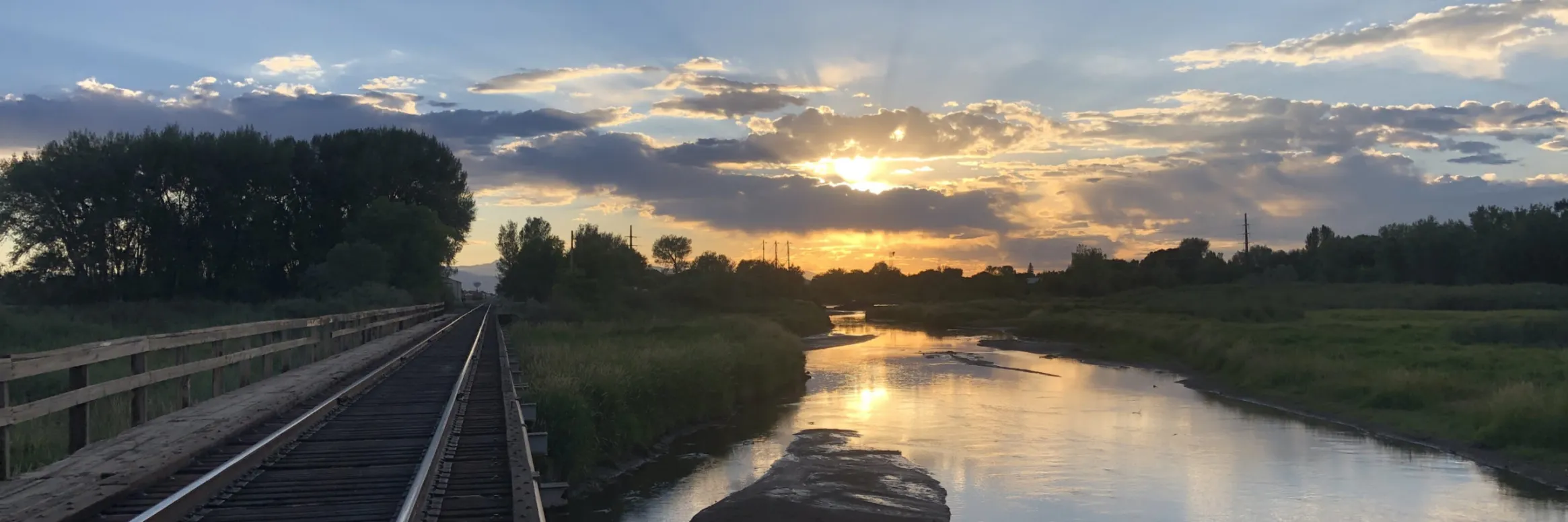
We headed over to Glenwood Springs from Kremmling on Day 2 going over Gore Pass to Toponas and Yampa then along CO-131 S. to the Colorado River Road where we joined the Colorado River. The route winds along the river to Dotsero where we picked up I-70 to Glenwood Springs through Glenwood Canyon. The river was runinng bank to bank. We were treated to beautiful cool and wet weather for most of the drive.
Colorado River along the Colorado River Road from CO-131 to Dotsero.
Charging was near Penny’s Diner in Yampa — a ChargePoint fast charger (CHAdeMO connector) installed by the Yampa Valley Electric Association.
The Grand River Diversion Dam, also known as the “Roller Dam”, was built in 1913 to divert water from the Colorado River to the Government Highline Canal, which farmers use to irrigate their lands in the Grand Valley. GVWUA is not participating the rebooted System Conservation Program after water managers couldn’t agree on how much farmers should be paid to cut back their water use. Photo credit: Bethany Blitz/Aspen Journalism
Three of western Colorado’s biggest irrigation districts are not participating on a large scale in a federally funded program to conserve water, and the amount of water saved by the program overall won’t be enough to rescue depleted reservoirs.
The rebooted System Conservation Program was one of the legs of the Upper Colorado River Commission’s 5-Point Plan, announced in July and aimed at protecting critical elevations in Lake Powell and Lake Mead, which have fallen to record-low levels in recent years because of overuse, drought and climate change. System conservation will take place in the four upper Colorado River basin states — Colorado, New Mexico, Wyoming and Utah — and will pay water users to cut back. It’s being funded by $125 million from the federal Inflation Reduction Act.
The total water estimated to be saved across the upper basin for this year of the restarted, temporary and voluntary System Conservation Program is nearly 39,000 acre-feet. By comparison, Lake Powell when full holds more than 23 million acre-feet; Ruedi Reservoir, on the Fryingpan River, can hold about 100,000 acre-feet. (An acre-foot is the amount of water needed to cover an acre of land to a depth of 1 foot and can supply one to two households a year.)
Becky Mitchell, Colorado commissioner to the UCRC, said in a UCRC meeting last month that although the upper basin will do its part in response to last summer’s calls from the federal government that the seven Colorado River basin states needed to conserve 2 million to 4 million acre-feet of water, the majority of that needs to come from cuts in the lower basin (California, Arizona and Nevada).
“(System conservation) will not resolve the crisis in the reservoirs,” she said.
Last month the UCRC approved moving forward with executing agreements with program participants, which are still being finalized.
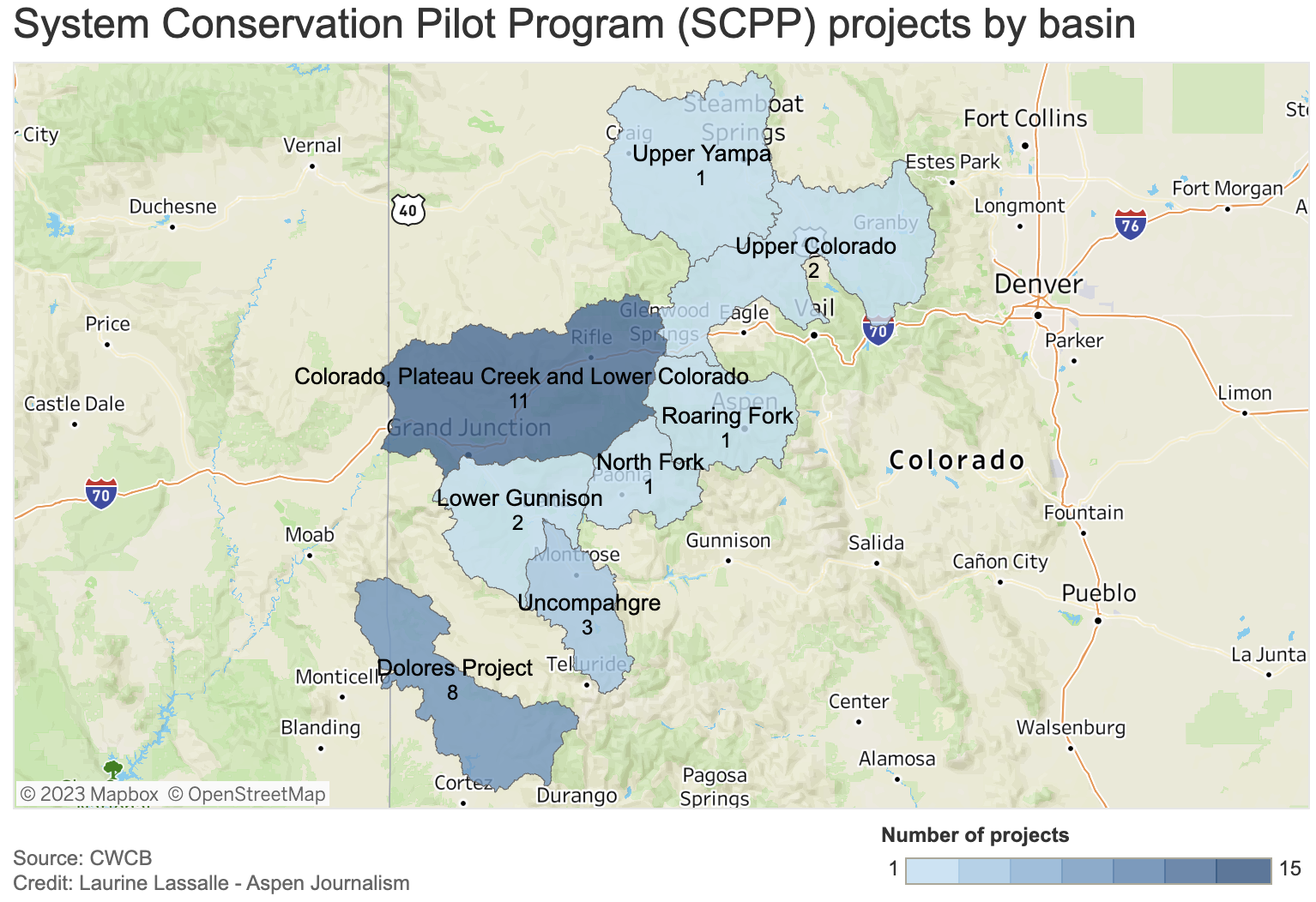
Although a goal of the program was to get participation across all water sectors — agricultural, municipal and industrial — all of the projects proposed in Colorado involve Western Slope agriculture. None of the state’s Front Range water providers, which collectively take about 500,000 acre-feet per year of the Colorado River’s headwaters across the Continental Divide to thirsty cities and farms, are participating.
Paying water users to irrigate less has long been controversial on the Western Slope, with fears that these temporary and voluntary programs could lead to a permanent “buy and dry” situation that would negatively impact rural farming and ranching communities.
Of the four upper basin states, Colorado has the largest number of projects (29) but the least amount of saved water (3,532 acre-feet). This is an indication that most of Colorado’s participants are proposing small projects. UCRC Executive Director Chuck Cullom said if the program is undertaken again, officials may consider a minimum size requirement because doing very small projects may not be worth it.
“From a practical standpoint of the cost of monitoring and administering a verification program for that (small number of) acres may not pencil out relative to the amount of water conserved,” Cullom said.
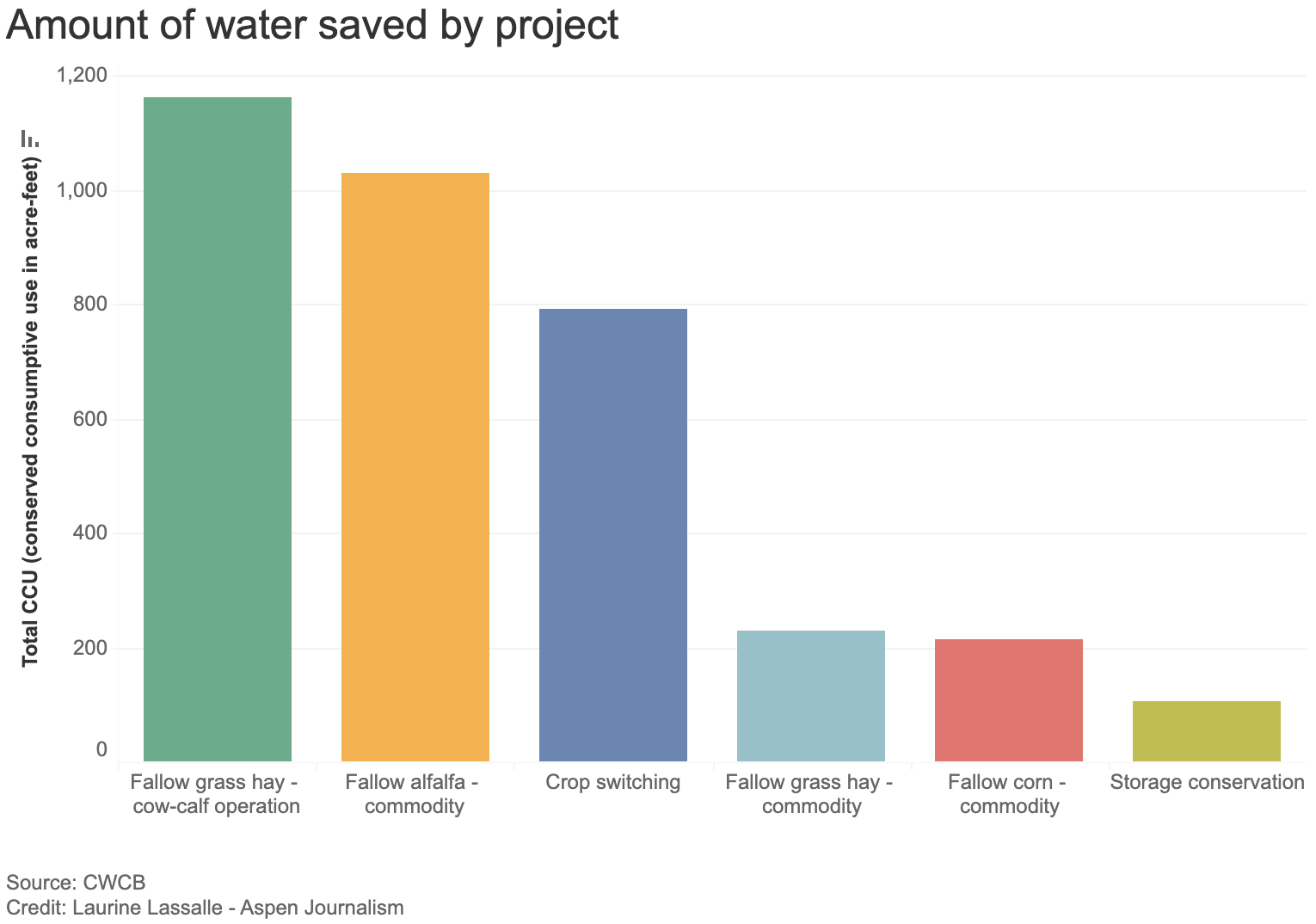
Of the 29 Colorado projects, most involve reducing water use for forage crops, according to information provided by UCRC. Eight involve fallowing grass hay as part of a cow-calf operation, saving 1,163 acre-feet of water; seven plan to fallow alfalfa and save 1,029 acre-feet; and eight propose switching to less-thirsty crops, saving 791 acre-feet.
The UCRC received 88 proposals across the four states, 72 of which met the qualifying criteria. Utah has 20 projects that meet preliminary criteria; Wyoming has 22 and New Mexico has one. The UCRC’s opening offer was $150 per acre-foot of saved water, but the average compensation will probably end up being higher — $434 per acre-foot, according to information provided by UCRC.
Grand Valley Water Users Association not participating
Although some water users in the Grand Valley Water Users Association participated in the original system conservation pilot program, which ran from 2015 to 2018 and conserved 47,000 acre-feet of water at a cost of about $8.6 million, they won’t be taking part this time around.
The Government Highline Canal flows past Highline State Park in the Grand Valley. CREDIT: BETHANY BLITZ/ASPEN JOURNALISM
GVWUA, whose Highline Canal delivers water to roughly 24,000 acres of farmland on the north side of the valley between Grand Junction and Mack, withdrew its application from the process after manager Tina Bergonzini said she couldn’t come to an agreement on the price with the UCRC. GVWUA had rejected the concept of paying farmers based on an amount of unused water, instead proposing to pay farmers for each acre of land they took out of production.
Individual farmers would have had to apply to the program through the association, which proposed to cap total member participation at 1,000 acres and 3,000 acre-feet of water.
GVWUA was asking for between $686 and $1,306 per each acre fallowed, depending on whether farmers reduced water use during the entire irrigation season or just part of it.
Bergonzini said the price represents what it would cost to administer the program in a way that provides equity and protection; at any lower price, the funding from system conservation would not be enough to cover the extra staff and engineering costs. Cullom said his organization was unlikely to approve those costs, so GVWUA withdrew its application.
“They were not wanting to pay per acre what we had requested,” Bergonzini said. “They had a line drawn in the sand and so did I.”
The Grand Valley Irrigation Company, which serves about 40,000 acres of farmland between Palisade and Mack, has four projects proposed within its service area, covering a total of 120 acres and 285 acre-feet of water savings.
“It’s not a very big amount,” said GVIC Assistant Superintendent Charlie Guenther. “I did hear from a handful of ag people that they didn’t want to be part of this because it sounded very technical and it was government involvement. That’s something that came up.”
Unlike GVWUA, individual water users within GVIC did not have to apply to the program through the irrigation company, and the company’s board did not take a stance on whether or not to support system conservation, according to Guenther.
There is just one conservation project proposed in the boundaries of the Uncompahgre Valley Water Users Association, the largest irrigation district in Western Colorado, at more than 83,000 acres of farmland in Delta and Montrose counties. The project would enroll about 33 acres in the program and would result in about 46 acre-feet of water savings.
UVWUA manager Steve Pope said the system conservation program didn’t get much interest from his water users because of the timing. Bergonzini agreed.
“They didn’t want to do a last-minute thing,” Pope said. “By the time this thing was rolled out, these guys had already made their decisions and they were already committed for the next season.”
Cullom has acknowledged that there were shortcomings with the program’s rollout. The UCRC unveiled details of the program in December, with an original application deadline of Feb. 1, which was later pushed to March 1 for this summer’s irrigation season.
“We need to do much better when we think about how to do this in the future, if we do this in the future,” he said. “We need more clarity on the data requirements, what we expect from a proposal. We need to give people more time to engage in understanding what the opportunity is and we need to start sooner. Start in the fall for an irrigation season instead of January.”
Conservation district concerns
The Western Slope’s two largest conservation districts — the Colorado River Water Conservation District and Southwestern Water Conservation District — submitted letters to the UCRC stating their concerns with the program. Mitchell had promised the districts that they could participate in the review and approval process for applications, thereby securing a measure of local control. But in March, she walked back that commitment, saying the UCRC had sole authority in the approval process.
The UCRC has released few details so far on project proposal specifics, and publicly available applications have been heavily redacted. In addition to redacting the applicants’ personal identifying information, nearly everything else has been blacked out: the precise location of projects; which streams and ditches are involved; details of the water rights involved; and how much the applicants are asking to be paid for their water.
The districts say this makes it impossible to meaningfully review them to determine whether the projects would cause injury to other water users. Their letters to the UCRC say the lack of transparency raises questions about whether public funds are being used wisely.
“In short, SWCD is very disappointed and concerned about the process that has been undertaken by the UCRC and the state of Colorado,” reads the letter from Southwestern General manager Steve Wolff.
In response, Amy Ostdiek, CWCB section chief for interstate, federal and water information, said that the review process respected project proponents’ privacy and that striking a balance between transparency and privacy is an ongoing effort.
“The Colorado State Engineer’s Office has been directly involved as implementation agreements and verification plans are developed to ensure no injury results from SCPP participation,” Ostdiek said in an email.
She said additional information will be available when the UCRC finalizes agreements with project participants, which should happen late this month, according to Cullom.
The 39,000 acre-feet of water across the four upper-basin states will do little to boost Lake Powell. It’s the proverbial drop in the bucket. But the political value of 39,000 acre-feet may be far greater than any benefit to the nation’s second-largest reservoir. The effort shows that upper-basin water managers are willing to do their part to prevent the system from crashing, but that part is small compared with the cuts they say are needed in the lower basin.
“It’s unlikely any system conservation stood up in the upper basin is going to move the needle,” Cullom said. “But it’s important for the upper basin to participate and contribute within the resources and the tools we have available, and what we are demonstrating in this process is that we do have tools, we do have resources. They are narrow in scope and small in volume.”
Click the link to read the article on The Deseret News website (Amy Joi O’Donoghue). Here’s an excerpt:
So far this year, staff at the Utah Geological Survey have taken 1,000 photos, spent 400 hours on landslides in the last six weeks and had 20 emergency responses.
Two homes have collapsed and one had to be razed by the city, Keach said.
The UGS Geologic Hazards Program conducted a reconnaissance to evaluate two landslides along U.S. Highway 89 in Logan Canyon in the Bear River Range, Cache County. They were reported on May 3, 2023. Details of these landslides are located here–https://t.co/1qcZrBahO9pic.twitter.com/uzvtzRywV8
Sources/Usage: Public Domain.
Research Hydrologist Martin Briggs (USGS) collects ground-penetrating radar (GPR) data. He is wearing special ice cleats on his shoes to have better traction walking on the ice. (April 2017)
Click the link to read the article on the USGS website:
What is Hydrology?
Water is one of our most precious natural resources. Without it, there would be no life on earth. Hydrology has evolved as a science in response to the need to understand the complex water system of the earth and help solve water problems. This hydrology primer gives you information about water on Earth and humans’ involvement and use of water.
Introduction
Hydrology is the study of water
Water is one of our most important natural resources. Without it, there would be no life on earth. The supply of water available for our use is limited by nature. Although there is plenty of water on earth, it is not always in the right place, at the right time and of the right quality. Adding to the problem is the increasing evidence that chemical wastes improperly discarded yesterday are showing up in our water supplies today. Hydrology has evolved as a science in response to the need to understand the complex water systems of the Earth and help solve water problems. Hydrologists play a vital role in finding solutions to water problems, and interesting and challenging careers are available to those who choose to study hydrology.
Water and People
Estimates of water use in the United States indicate that about 355 billion gallons per day (one thousand million gallons per day, abbreviated Bgal/d) were withdrawn for all uses during 2010. This total has declined about 17 percent since 1980. Fresh groundwater withdrawals (76.0 Bgal/d) during 2010 were 8 percent less than during 1980. Fresh surface-water withdrawals for 2010 were 230 Bgal/d, 18 percent less than in 1980.
Much of our water use is hidden. Think about what you had for lunch. A hamburger, for example, requires water to raise wheat for the bun, to grow hay and corn to feed the cattle and to process the bread and beef. Together with french fries and a soft drink, this all-American meal uses about 1,500 gallons of water — enough to fill a small swimming pool. How about your clothes? To grow cotton for a pair of jeans takes about 400 gallons. A shirt requires about 400 gallons. How do you get to school or to the store? To produce the amount of finished steel in a car has in the past required about 32,000 gallons of water. Similarly, the steel in a 30-pound bicycle required 480 gallons. This shows that industry must continue to strive to reduce water use through manufacturing processes that use less water, and through recycling of water.
What is Hydrology?
Hydrology is the science that encompasses the occurrence, distribution, movement and properties of the waters of the earth and their relationship with the environment within each phase of the hydrologic cycle. The water cycle, or hydrologic cycle, is a continuous process by which water is purified by evaporation and transported from the earth’s surface (including the oceans) to the atmosphere and back to the land and oceans. All of the physical, chemical and biological processes involving water as it travels its various paths in the atmosphere, over and beneath the earth’s surface and through growing plants, are of interest to those who study the hydrologic cycle.
There are many pathways the water may take in its continuous cycle of falling as rainfall or snowfall and returning to the atmosphere. It may be captured for millions of years in polar ice caps. It may flow to rivers and finally to the sea. It may soak into the soil to be evaporated directly from the soil surface as it dries or betranspired by growing plants. It may percolate through the soil to ground water reservoirs (aquifers) to be stored or it may flow to wells or springs or back to streams by seepage. The cycle for water may be short, or it may take millions of years.
People tap the water cycle for their own uses. Water is diverted temporarily from one part of the cycle by pumping it from the ground or drawing it from a river or lake. It is used for a variety of activities such as households, businesses and industries; for irrigation of farms and parklands; and for production of electric power. After use, water is returned to another part of the cycle: perhaps discharged downstream or allowed to soak into the ground. Used water normally is lower in quality, even after treatment, which often poses a problem for downstream users.
The hydrologist studies the fundamental transport processes to be able to describe the quantity and quality of water as it moves through the cycle (evaporation, precipitation, streamflow, infiltration, groundwater flow, and other components). The engineering hydrologist, or water resources engineer, is involved in the planning, analysis, design, construction and operation of projects for the control, utilization, and management of water resources. Water resources problems are also the concern of meteorologists, oceanographers, geologists, chemists, physicists, biologists, economists, political scientists, specialists in applied mathematics and computer science, and engineers in several fields.
What Hydrologists Do?
Hydrologists apply scientific knowledge and mathematical principles to solve water-related problems in society: problems of quantity, quality and availability. They may be concerned with finding water supplies for cities or irrigated farms, or controlling river flooding or soil erosion. Or, they may work in environmental protection: preventing or cleaning up pollution or locating sites for safe disposal of hazardous wastes.
Persons trained in hydrology may have a wide variety of job titles. Scientists and engineers in hydrology may be involved in both field investigations and office work. In the field, they may collect basic data, oversee testing of water quality, direct field crews and work with equipment. Many jobs require travel, some abroad. A hydrologist may spend considerable time doing field work in remote and rugged terrain. In the office, hydrologists do many things such as interpreting hydrologic data and performing analyses for determining possible water supplies. Much of their work relies on computers for organizing, summarizing and analyzing masses of data, and for modeling studies such as the prediction of flooding and the consequences of reservoir releases or the effect of leaking underground oil storage tanks.
The work of hydrologists is as varied as the uses of water and may range from planning multimillion dollar interstate water projects to advising homeowners about backyard drainage problems.
San Luis Valley. Photo credit: The Alamosa Citizen
Surface Water
Most cities meet their needs for water by withdrawing it from the nearest river, lake or reservoir. Hydrologists help cities by collecting and analyzing the data needed to predict how much water is available from local supplies and whether it will be sufficient to meet the city’s projected future needs. To do this, hydrologists study records of rainfall, snowpack depths and river flows that are collected and compiled by hydrologists in various government agencies. They inventory the extent river flow already is being used by others.
Managing reservoirs can be quite complex, because they generally serve many purposes. Reservoirs increase the reliability of local water supplies. Hydrologists use topographic maps and aerial photographs to determine where the reservoir shorelines will be and to calculate reservoir depths and storage capacity. This work ensures that, even at maximum capacity, no highways, railroads or homes would be flooded.
Deciding how much water to release and how much to store depends upon the time of year, flow predictions for the next several months, and the needs of irrigators and cities as well as downstream water-users that rely on the reservoir. If the reservoir also is used for recreation or for generation of hydroelectric power, those requirements must be considered. Decisions must be coordinated with other reservoir managers along the river. Hydrologists collect the necessary information, enter it into a computer, and run computer models to predict the results under various operating strategies. On the basis of these studies, reservoir managers can make the best decision for those involved.
The availability of surface water for swimming, drinking, industrial or other uses sometimes is restricted because of pollution. Pollution can be merely an unsightly and inconvenient nuisance, or it can be an invisible, but deadly, threat to the health of people, plants and animals.
Hydrologists assist public health officials in monitoring public water supplies to ensure that health standards are met. When pollution is discovered, environmental engineers work with hydrologists in devising the necessary sampling program. Water quality in estuaries, streams, rivers and lakes must be monitored, and the health of fish, plants and wildlife along their stretches surveyed. Related work concerns acid rain and its effects on aquatic life, and the behavior of toxic metals and organic chemicals in aquatic environments. Hydrologic and water quality mathematical models are developed and used by hydrologists for planning and management and predicting water quality effects of changed conditions. Simple analyses such as pH, turbidity, and oxygen content may be done by hydrologists in the field. Other chemical analyses require more sophisticated laboratory equipment. In the past, municipal and industrial sewage was a major source of pollution for streams and lakes. Such wastes often received only minimal treatment, or raw wastes were dumped into rivers. Today, we are more aware of the consequences of such actions, and billions of dollars must be invested in pollution-control equipment to protect the waters of the earth. Other sources of pollution are more difficult to identify and control. These include road deicing salts, storm runoff from urban areas and farmland, and erosion from construction sites.
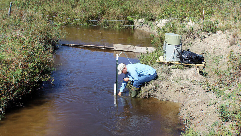
Researchers with the University of Nebraska-Lincoln take groundwater samples from the Loup River in the Sandhills of Nebraska in September 2018. By sampling groundwater and determining its age, they hope to determine whether predictions for groundwater discharge rates and contamination removal in watersheds are accurate. Photo credit: Troy Gilmore
Groundwater
Groundwater, pumped from beneath the earth’s surface, is often cheaper, more convenient and less vulnerable to pollution than surface water. Therefore, it is commonly used for public water supplies. Groundwater provides the largest source of usable water storage in the United States. Underground reservoirs contain far more water than the capacity of all surface reservoirs and lakes, including the Great Lakes. In some areas, ground water may be the only option. Some municipalities survive solely on groundwater.
Hydrologists estimate the volume of water stored underground by measuring water levels in local wells and by examining geologic records from well-drilling to determine the extent, depth and thickness of water-bearing sediments and rocks. Before an investment is made in full-sized wells, hydrologists may supervise the drilling of test wells. They note the depths at which water is encountered and collect samples of soils, rock and water for laboratory analyses. They may run a variety of geophysical tests on the completed hole, keeping and accurate log of their observations and test results. Hydrologists determine the most efficient pumping rate by monitoring the extent that water levels drop in the pumped well and in its nearest neighbors. Pumping the well too fast could cause it to go dry or could interfere with neighboring wells. Along the coast, overpumping can cause saltwater intrusion. By plotting and analyzing these data, hydrologists can estimate the maximum and optimum yields of the well.
Polluted groundwater is less visible, but more insidious and difficult to clean up, than pollution in rivers and lakes. Ground water pollution most often results from improper disposal of wastes on land. Major sources include industrial and household chemicals and garbage landfills, industrial waste lagoons, tailings and process wastewater from mines, oil field brine pits, leaking underground oil storage tanks and pipelines, sewage sludge and septic systems. Hydrologists provide guidance in the location of monitoring wells around waste disposal sites and sample them at regular intervals to determine if undesirable leachate — contaminated water containing toxic or hazardous chemicals — is reaching the ground water.
In polluted areas, hydrologists may collect soil and water samples to identify the type and extent of contamination. The chemical data then are plotted on a map to show the size and direction of waste movement. In complex situations, computer modeling of water flow and waste migration provides guidance for a clean-up program. In extreme cases, remedial actions may require excavation of the polluted soil. Today, most people and industries realize that the amount of money invested in prevention is far less than that of cleanup. Hydrologists often are consulted for selection of proper sites for new waste disposal facilities. The danger of pollution is minimized by locating wells in areas of deep ground water and impermeable soils. Other practices include lining the bottom of a landfill with watertight materials, collecting any leachate with drains, and keeping the landfill surface covered as much as possible. Careful monitoring is always necessary.
Careers in Hydrology
Students who plan to become hydrologists need a strong emphasis in mathematics, statistics, geology, physics, computer science, chemistry and biology. In addition, sufficient background in other subjects — economics, public finance, environmental law, government policy — is needed to communicate with experts in these fields and to understand the implications of their work on hydrology. Communicating clearly in writing and speech is a basic requirement essential for any professional person. Hydrologists should be able to work well with people, not only as part of a team with other scientists and engineers, but also in public relations, whether it be advising governmental leaders or informing the general public on water issues. Hydrology offers a variety of interesting and challenging career choices for today and tomorrow. It’s a field worth considering.
Source: Hydrology: The Study of Water and Water Problems A Challenge for Today and Tomorrow, a publication of the Universities Council on Water Resources
Click the link to read the article on The Denver Post website (Bruce Finley). Here’s an excerpt:
Colorado’s mountain snowpack is starting to melt faster, potentially bringing more high water after recent heavy rain turned some of the state’s typically feeble creeks into torrents. Big water rose to levels up to 80 times higher than the norm during rain bursts in Colorado Front Range cities this week, forcing police in Denver to warn creekside campers who lack housing to clear out, and scrambling 30 firefighters in Colorado Springs who recovered the body of a person swept away. More rain was falling Friday — and National Weather Service meteorologists forecast thunderstorms nearly every day next week — saturating soils to the point that water more easily gains momentum…
“Certainly on the Western Slope, all of our gauge readings will increase as the snow melts over the next few weeks,” Forbes said. “We are preparing for high flows on Colorado’s Western Slope over the next two weeks to a month. For flooding risk, the slower it melts the better. That all depends on the weather.”
[…]
The mountain snowpack in watersheds feeding the Dolores, Animas, Gunnison, Yampa, Colorado and other rivers in the farthest western parts of Colorado this year measured exceptionally high and promise the biggest runoff. Mountains east of the Continental Divide received relatively less snow. The South Platte watershed had snowpack near average, and snowpack in the Arkansas River Basin lagged, peaking at around 74% of the 1999-2020 norm. Meanwhile, heavy rain — falling in scattered bursts around Colorado since May 9 — has led to unusually high flows in creeks and rivers. On Thursday, the Arkansas River overflowed its banks in southeastern Colorado near La Junta, inundating U.S. 50. Coal Creek west of metro Denver last week overflowed banks, forcing closures along Colorado 52…
Water levels in the South Platte River northeast of Denver at Fort Morgan, averaging over 36 years around 300 cfs, hit a high flow on May 14 of 5,930 cfs, data show. And on the Arkansas River a mile east of Pueblo, flows exceeded the norm of 900 cfs fivefold at 4,780 cfs on May 12…
Here at Lee’s Ferry, seven southwestern American states divided up the Colorado River with the 1922 river compact. Every single drop was spoken for, between Wyoming, Colorado, New Mexico, Utah, Nevada, Arizona, California, and later Mexico. The water was destined for colonized farmland and cities. But crucially, that 1922 compact denied 30 different Indigenous tribes any share of the water that they needed to survive in the hot and dry southwest. While the federal government helped states build pipes, dams and reservoirs to access the water they were allocated, it didn’t do the same for Indigenous reservations, and many people living on those reservations didn’t know what water they could use.
From the 2018 Tribal Water Study, this graphic shows the location of the 29 federally-recognized tribes in the Colorado River Basin. Map credit: USBR
This was an abrupt departure from the way tribes had lived before white colonizers arrived in the West and forced the tribes onto reservations. For thousands of years, many Indigenous people moved with the river; they adapted to it and responded to it. This is how Daryl Vigil’s ancestors lived in communion with the river.
“That’s the level of reverence you give that stream or that river,” Vigil, a member of the Jicarilla Apache Nation and of Jemez and Zia Pueblo descent, said. “The dances all revolved around this cyclical nature of the environment and most importantly, rain and snow in terms of what it meant to our existence.”
But as the colonizers built gigantic dams and carved up the river, filling Lake Mead and Lake Powell, the Jicarilla Apache and dozens of other tribes that rely on the Colorado River no longer had the same access to the water as they once did. This was the West that Vigil was born into and where he grew up on three different reservations – at times without indoor plumbing. He now lives on the Jicarilla Apache Reservation north of Santa Fe, New Mexico, and until recently was the tribe’s water administrator. He is among the most recent generation of leaders in a decades-long fight for tribes to regain rights to the water they had access to for thousands of years.
“Part of the need to build economies is also based in an ability to build a basic infrastructure that everybody else in this country is supposed to be entitled to: water, wastewater,” he said. “Native American communities [are] 19 times more likely to not have indoor plumbing.”
Updated Colorado River 4-Panel plot thru Water Year 2022 showing reservoirs, flows, temperatures and precipitation. All trends are in the wrong direction. Since original 2017 plot, conditions have deteriorated significantly. Brad Udall via Twitter: https://twitter.com/bradudall/status/1593316262041436160
“My message for 20 years now has been: watch out,” said Brad Udall from his home near Boulder, Colorado. “We’ve overdone it, we need to cut back and this is going to get worse. And that’s not a message that, for years, anybody wanted to hear.”
Remember the Colorado River water rights that took 20 years for the Jicarilla Apache Nation to win? They and other tribes have collectively secured rights to use 25 percent of the water in the river. That’s more than Arizona has rights to. But here’s the catch: reservoirs and canals the reservations need to access their full supplies of water don’t exist yet. Without that infrastructure, the water is still going to states, rather than the tribes. This is why many people, including Vigil and Udall, want tribes to have an equal say in how we save the Colorado River in the face of climate change.
Lands in Northern Water’s collection system scarred by East Troublesome Fire. October 2020. Credit: Northern Water
Click the link to read the article on the Environmental Research Letters website (Kristina A Dahl, John T Abatzoglou, Carly A Phillips, J Pablo Ortiz-Partida, Rachel Licker, L Delta Merner, and Brenda Ekwurzel). Here’s the abstract:
Increases in burned forest area across the western United States and southwestern Canada over the last several decades have been partially driven by a rise in vapor pressure deficit (VPD), a measure of the atmosphere’s drying power that is significantly influenced by human-caused climate change. Previous research has quantified the contribution of carbon emissions traced back to a set of 88 major fossil fuel producers and cement manufacturers to historical global mean temperature rise. In this study, we extend that research into the domain of forest fires. We use a global energy balance carbon-cycle model, a suite of climate models, and a burned area (BA) model to determine the contribution of emissions traced to the major carbon producers to the long-term increase in VPD during 1901–2021 and to cumulative forest fire area during 1986–2021 in the western US and southwestern Canada. Based on climate model data, we find that emissions traced to these carbon producers contributed 48% (interquartile range (IQR) 38%–63%) of the long-term rise in VPD between 1901 and 2021. BA modeling indicates that these emissions also contributed 37% (IQR 26%–47%) of the cumulative area burned by forest fires between 1986 and 2021 in the western US and southwestern Canada. The increase in VPD in this region is linked to both increased fire activity and the region’s current and prolonged megadrought. As loss and damage from these hazards mounts, this research can inform public and legal dialogues regarding the responsibility carbon producers bear for addressing past, present, and future climate risks associated with fires and drought in the western US and southwestern Canada.
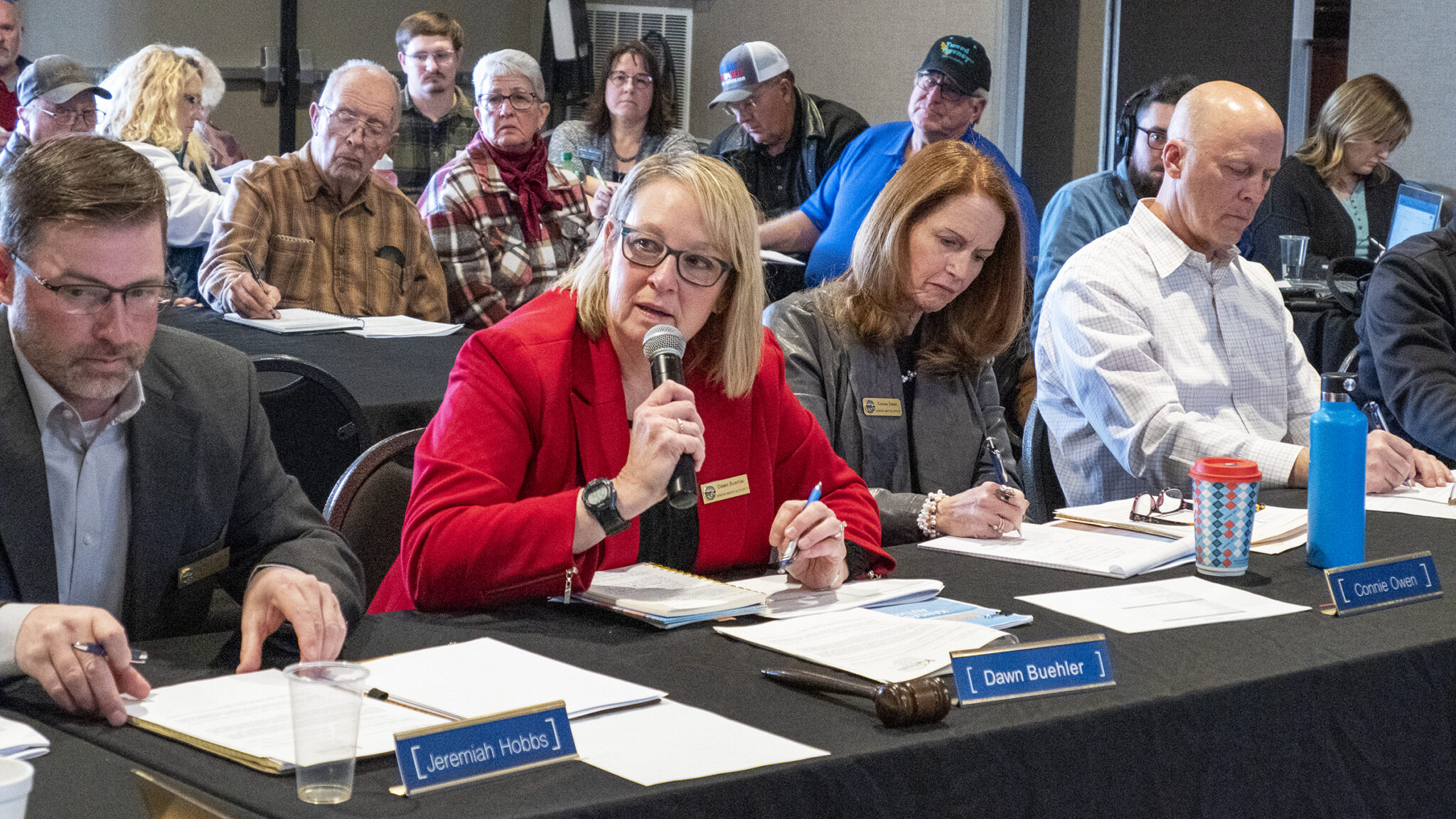
Dawn Buehler, chairwoman of the Kansas Water Authority, presides over a meeting Wednesday in Colby. The authority voted to adopt language saying Kansas should not deplete the Ogallala Aquifer. (Allison Kite/Kansas Reflector)
COLBY [December 15, 2022] — Kansas should scrap its de facto policy of draining the Ogallala Aquifer, a state board decided Wednesday.
Instead, the board said, the Kansas government should take steps to stop the decline of the aquifer and save it for future generations.
“It has taken decades for this to be said formally in writing by an official state body,” said Connie Owen, director of the Kansas Water Office. “… This is nothing less than historic.”
Saving the water source that supports Western Kansas’ economy and communities may seem like an obvious stance to take, but for about 70 years, the state’s policies and management decisions have reflected the idea that eventually, the Ogallala would dry up, said Earl Lewis, Kansas’ chief engineer.
The Kansas Water Authority, which is made up of agricultural and industrial water users and utilities, wants to chart a new course. It voted almost unanimously Wednesday to recommend that the state scrap the policy of “planned depletion.”
“It’s time to deal with this while we still have some choices,” said John Bailey, a member of the Kansas Water Authority from Pittsburg. “If we don’t, we’re going to find ourselves in a very bad situation.”
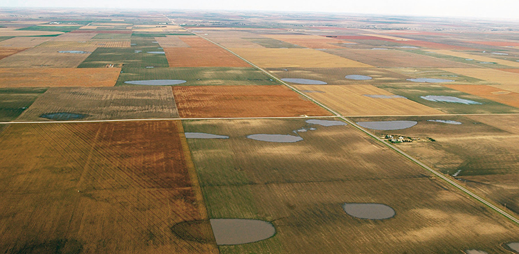
Ogallala Aquifer. Credit: Big Pivots
The Ogallala Aquifer, one of the world’s largest underground sources of fresh water, stretches across parts of eight states from South Dakota to Texas. After World War II farmers started pumping water from it to irrigate crops in arid western Kansas, establishing the region as a booming farming economy. For decades, the water was used with little thought of ensuring enough remained for future generations.
Draining the aquifer would fundamentally change life in western Kansas. Farm properties would lose their value if there’s no water to grow a crop. Families could lose their livelihoods and communities could disappear.
But while it’s widely accepted that the Ogallala is essential to western Kansas, Kansas Water Authority chairwoman Dawn Buehler said many farmers have been waiting on the government to tell them it’s time to do something.
“We’ve heard that over and over from people — that, ‘Well, you know, we’re not at a dangerous zone yet because they’ll let us know when it’s time,’ ” Buehler said.
She continued: “I think the importance of today was saying, ‘It’s time.’ ”
Kansas Geological Survey at the University of Kansas is embarking on a two-year study of playas that hold water during wet periods in Scott County and elsewhere to better understand their role in recharge of the underground Ogallala aquifer. (Bill Johnson/Kansas Geological Survey)
A vote to change course
The Kansas Water Authority, which meets roughly every two months in different locations around the state, voted Wednesday to place language in the body’s annual report to the governor and legislature saying the “policy of planned depletion of the Ogallala Aquifer is no longer in the best interest of the state of Kansas.”
The report will also recommend the state create a formal process to establish goals and actions to “halt the decline of the Ogallala Aquifer while promoting flexible and innovative management within a timeframe that achieves agricultural productivity, thriving economies and vibrant communities — now and for future generations of Kansans.”
It had wide support among the authority members.
“My opinion of this is that it should have been done 15 years ago or 20,” said Lynn Goossen, a farmer from Colby who serves on the Kansas Water Authority and the board of the groundwater management district in northwest Kansas.
Goossen said there are parts of Kansas where the aquifer still has abundant water left but that people are “sticking their heads in the sand” rather than saving it.
Kansas Aqueduct route via Circle of Blue
Some water users have pursued a longshot idea to draw water from the Missouri River via an aqueduct to southwest Kansas. They trucked 6,000 gallons of water from northeast Kansas across the state as a “proof of concept.”
The goal to “halt” the decline of the aquifer gave pause to one member of the authority who asked that the statement instead say officials should “address” the decline of the aquifer.
Randy Hayzlett, a farmer and rancher from Lakin who serves on the authority, was the lone vote against the language, though the subsequent vote to send the full annual report to policymakers was unanimous.
Hayzlett said he couldn’t support establishing the goal without details about what it would mean to “halt” the decline of the aquifer.
“That’s a pretty strong word, and it’s going to affect a lot of people,” he said.
Hayzlett said he wanted to do everything possible to remedy the decline of the Ogallala but didn’t want to throw a word out there without a plan to achieve it.
“Is it going to halt declining the aquifer? Is it going to halt the economy of western Kansas?” he said. “Just what’s it going to put a cap on and then how are we going to get there?”
Lewis said Kansas has talked about the issue of the Ogallala Aquifer for 50 years. If authority members wait for a plan, he said, they’ll get bogged down in the details.
“What you’re doing is really setting a course,” Lewis said. “You’re saying, ‘I want to go in that direction. … I don’t know how I’m going to get there and it’s going to take a lot of us working together to get there.’ ”
Saying the state will fare best if it stands together when it comes to protecting Colorado River water rights, Western Slope legislators are hailing a bill that creates a drought task force.
“It’s to get Colorado to come to the table and start talking about what we can do, rather than somebody on the eastern side of the state, or the governor, talking,” Rep. Marc Catlin, R-Montrose, who was House sponsor of Senate Bill 295, with Rep. Julie McCluskie, D-Dillon, House speaker. “We’re trying to get people from the Western Slope, particularly since the Western Slope is going to have to deal with it.”
Senate Bill 295 passed 63-2, with Sens. Perry Will, R-Newcastle, and Dylan Robert, D-Eagle, carrying it in the Senate. The bill creates a Colorado River Drought Task Force, with subcommittees, to guide the development of water legislation. It is to include the Ute Mountain Ute and Southern Ute tribes, regional water conservation districts, local government, farmers, ranchers, environmental nonprofits and the Colorado Department of Natural Resources. Members are charged with developing steps and tools the legislature can use to address drought in the Colorado River Basin and commitments under the Colorado River Compact through conservation of the river and its tributaries, such as the Gunnison River and the Uncompahgre. If the bill creating the task force is signed into law, its members have a short window to act: between July and Dec. 15, they are to furnish their recommendations and a summary of their work to the legislative water resources and agricultural review committee…
The bill says recommendations need to be for programs that can be reasonably implemented in a way that does not harm economic or environmental concerns in any sub-basin or region in the state. The recommendations must also fall in line with the 2019 Colorado River Drought Contingency Plan. The recommendations must further ensure any program related to acquiring water rights is voluntary, temporary and compensated, while also looking at revenue sources for the acquisition of program water. [Perry] Will and [Marc] Catlin worry about entities that are purchasing farm land, as well as buying or leasing water, especially if they are not providing adequate compensation…
“The Uncompahgre (River), we’ve got the oldest, biggest water right on the Western Slope of Colorado. Certainly, there are people looking at us,” Catlin said. He said speculators need to understand that when they buy water, they are affecting the entire ag community, not just individual farmers — and that reality needs to be part of the conversation.
WAM bought this 57-acre parcel as part of a $6 million deal in January 2020, leading some to suspect the company was engaging in investment water speculation. WAM’s activity in the Grand Valley helped prompt state legislators to propose a bill aimed at curbing speculation.
CREDIT: BETHANY BLITZ/ASPEN JOURNALISM
High snowpack in the San Juan River Basin this year has led to an above-average inflow forecast into the Navajo Reservoir. The latest most probable inflow forecast from the Colorado Basin River Forecast Center has increased to 160% of average inflows due to snowmelt runoff from April through July.
The forecast now allows for a spring peak release as recommended by the San Juan River Basin Recovery Implementation Program (SJRIP). The release will ramp up slowly, peaking at 5,000 cfs for approximately 21 days before ramping back down.
As this operation is entirely dependent on weather, inflows, and on-the-ground conditions, this schedule may change.
This operation is subject to changes in river flows and weather conditions and will be coordinated daily with local, state, and federal agencies to ensure objectives are met in a safe manner.
Areas in the immediate vicinity of the river channel may be unstable and dangerous. River crossing may change and be impassable as flows increase. Please use extra caution near the river channel and protect or remove any valuable property in these areas.
5/19/2023
Fri
TIME
RELEASE (CFS)
6:00 AM
2000
8:00 AM
2200
10:00 AM
2400
12:00 PM
2600
2:00 PM
2800
4:00 PM
3000
5/22/2023
Mon
TIME
RELEASE (CFS)
6:00 AM
3000
8:00 AM
3200
10:00 AM
3500
12:00 PM
3800
2:00 PM
4000
5/23/2023
Tues
TIME
RELEASE (CFS)
8:00 AM
4000
10:00 AM
4300
12:00 PM
4600
For more information, please see the following resources below: