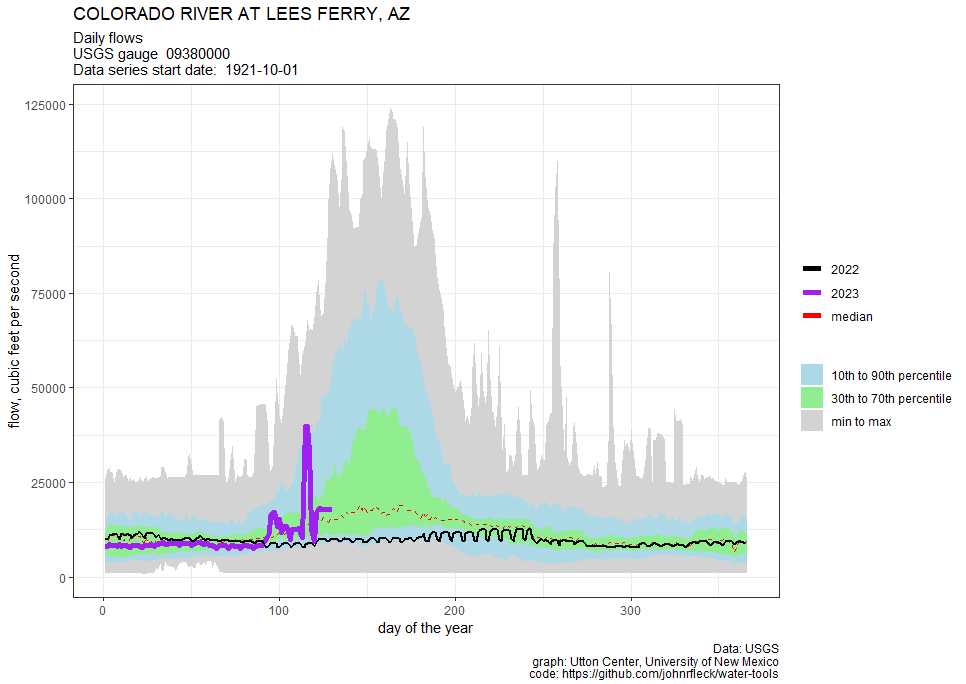
Graph showing increased flow this year on the Colorado River at Lees Ferry gauge. Credit: John Fleck: Utton Center University of New Mexico
Click the link to read the article on the InkStain website (John Fleck):
The Bureau of Reclamation is currently blasting water out the bottom of Glen Canyon Dam as Lake Powell rises with this year’s big snowmelt.
(The big spike is an experimental flow pulse.)
Lake Mead, as a result, is rising for the first time in a while, with the wrecked speedboats disappearing – and with it, the apparent sense of urgency about cutting our water use.
Downstream the big ag districts and municipalities are taking advantage of the wet year to put off decisions about how, in the long term, to bring water use into balance with available supply.
THE LOWER BASIN STRUCTURAL DEFICIT, CIRCA 2023
The classic Reclamation “structural deficit” slide put the gap between available water and use when the Upper Basin meets its legal delivery requirement, and folks in the Lower Basin take their full allotment, at 1.2 million acre feet per year.
Under the latest official Reclamation forecast, the Lower Basin states are reducing their use by 756,000 acre feet below their nominal 7.5 million acre foot allotments. Yay for using less water! But it still falls short of the 1.2 million acre feet needed to close the structural deficit, and is far less than the amount that might be needed to refill a bit, to provide a safety cushion against a run of bad years. The only reason Lake Mead is projected to rise this year is thanks to a big snowpack and a bunch of resulting bonus water from the Upper Basin.
Here are the numbers, with officially forecast 2023 use in millions of acre feet as of May 10, 2023
2023
pct
California
4.196
95.4%
Arizona
2.334
83.4%
Nevada
0.214
71.3%
In other words, the pattern of Lower Basin water users putting off hard decisions about reducing their use, depending instead on Upper Basin bonus water, continues. (See “Hookers and Blow on the Lower Colorado River” – this has been going on a while.)
It is possible that Lower Basin use is gonna drop more this year than the official forecast suggests, that the current talking now underway will yield more water use reductions. I keep hearing that. I keep not seeing it in the official numbers.
UPPER BASIN WATER USE REDUCTION EFFORTS
According to the Denver Post’s Conrad Swanson, quoting the Upper Basin’s Chuck Cullom, the Upper Basin’s system conservation program hasn’t come up with much water either
PLEASE TELL US YOUR PLAN
That’s it. That’s my ask of the Colorado River Basin leadership community.
The lower end of the Low Flow Conveyance Channel as it fades away miles above its intended destination of Elephant Butte Reservoir. Source: Google Earth.
A few months ago a reader and Western water expert clued me in on recent developments related to the Low Flow Conveyance Channel. Had she told me this in person I probably would have blushed and fumbled around for an intelligent response before finally resigning and asking:
Say, what?!
Because, well, I had no friggin’ idea what she was talking about.
And yet, I should have known, because the Low Flow Conveyance Channel — or LFCC — is a classic example of how folks in the West try to engineer their way out of the region’s aridity and, ultimately, fail.
The LFCC might be considered the infrastructure love-child from the coupling of the Rio Grande Compact and, well, silt — a lot of it. The compact, signed in 1938, divided the waters of the Rio Grande between Colorado, New Mexico, and Texas. Whereas the Colorado River Compact allocates a set amount of water to each group of states, the Rio Grande Compact uses a more complicated distribution formula based on flows at specific river gages.
Among other things, it requires New Mexico to deliver a certain percentage of the Rio Grande’s flow to Elephant Butte Reservoir, where it is stored for Texas. This is strange, I know, because the reservoir is in New Mexico, not Texas, and not even that close to the latter state. But these water compacts can be like that. New Mexico can accrue up to 200,000 acre feet of water debt to Texas and still be in compact compliance, giving the upstreamers some breathing room during dry years.
The Compact went into effect in 1939, a dry year on the Rio Grande; 1940 was similarly meagre, with a peak streamflow under 3,000 cfs at the Otowi Bridge gage. But the Rio flooded, big time, in 1941 and 1942, peaking above 22,000 cfs at Otowi. That kind of big water tends to pick up big silt — especially from the Rio Puerco, a Rio Grande tributary — and when the river started losing energy at the slackwater above Elephant Butte Reservoir, the sediment fell out of the flow, accumulating on the river bed. If you’ve ever rafted the lower San Juan River, you’ve experienced a similarly silty phenomenon below Slickhorn Canyon.
This shows peak streamflows on the Rio Grande way upstream of the Low Flow Conveyance Channel. But it illustrates how gargantuan the 1941-42 floods that led to the channel’s construction were. USGS.
The silt filled in and plugged the existing river channel, sending the water out across a much wider, shallower plain, and forced the railroad to raise its tracks repeatedly along a section that crosses the river. During ensuing low-water years, the river was so spread out that most of it evaporated or seeped into the silt or was sucked up by encroaching tamarisk before reaching the reservoir. Before long, New Mexico was deep in water-debt to Texas, and in 1951 owed the downstream state 325,000 acre-feet, putting New Mexico out of compliance with the compact.
This is where the engineers come in. In order to get the river to Texas they would divert it around the river bed, kind of like providing fish passage around dams for salmon. And they would do this by building a deep, narrow, 75-mile long ditch from San Acacia to the reservoir that would carry water and silt more efficiently and result in less evaporation. It would be called the Low Flow Conveyance Channel because it would convey the river during low flow. Construction began in 1951 and the LFCC went into operation in 1959.
For the next two decades, the LFCC did what it was supposed to do: Carry up to 2,000 cfs of the river’s flow around the river, itself, and deposit it in Elephant Butte Reservoir, where it was stored for Texas. New Mexico’s substantial water debt slowly shrank, finally disappearing in 1972. Despite the channel’s name, during this time it carried most of the river’s water during high flows and low, thus depriving the riparian zone of its life-giving river and altering the ecosystem.
1983 – Color photo of Glen Canyon Dam spillway failure from cavitation, via OnTheColorado.com
The 1980s were notoriously wet years for most of the Southwest and somewhat perilous times for the infrastructure built to help states comply with water compacts. Glen Canyon Dam, constructed primarily to allow Upper Colorado River Basin states to deliver the obligated amount of water to the Lower Basin, was pushed to the brink by massive snowmelt in 1983 and, to a lesser extent, in 1984.
The Rio Grande ran large during those years, too. Elephant Butte Reservoir filled up completely, inundating the lower reaches of the LFCC. Silt happens, it turns out. When the reservoir levels declined several years later, the last 15 miles of the channel had essentially disappeared under a thick layer of sediment. No longer able to carry water to the reservoir, the LFCC was shut down in 1985 and hasn’t been used to convey the Rio Grande since.
But the first 60 miles or so of the LFCC remains, running alongside the Rio Grande like its more linear twin, separated by an earthen levee built to keep a flooding river from inundating and wrecking the canal. Bizarrely, the river channel is about 10 feet or more above the canal, due to all of that sedimentation over the years, making flooding more likely. And that means more engineering, and maintenance dollars, are required to protect the engineered canal. In a weird Anthropocene-esque twist, the canal now serves an environmental purpose: It catches and conveys irrigation runoff and groundwater to the Bosque del Apache National Wildlife Refuge, keeping the wetlands there wet.
The Rio Grande at the key Otowi Bridge gage is looking pretty darned healthy this year … so far. But the snow’s melting fast.
As Rio Grande flows continue to decline and New Mexico piles up water debts to Texas, the possibility of reopening the LFCC grows. The Middle Rio Grande Conservancy District, which acquired the northern end of the channel from the feds, has talked about using it again to get more river water downstream to Texas (thereby freeing up more Rio Grande water for New Mexico irrigators). And the state engineer’s office asked lawmakers to budget $30 million for the LFCC.
But it would take far more than that to clean out, rehabilitate, and extend the lower section so it could reach the shrinking reservoir. And even then, it could only be used on a limited basis, since diverting the entire flow of the river would run up against endangered species laws and other environmental concerns. Elizabeth Miller wrote a strong piece for NM In Depth about efforts to reopen the channel and environmentalists’ concerns. It’s well worth a read.
For now, however, the Low Flow Conveyance Channel will stand as a reminder that while engineering our way out of a short-term drought may be somewhat effective, it usually doesn’t work in the long-term. To survive ongoing aridification we must dispense with dams and canals and rethink our relationship to this landscape and overhaul the way we use diminishing amounts of water.
Elephant Butte Reservoir back in the day nearly full
This image was taken during the peak outflow from the Gold King Mine spill at 10:57 a.m. Aug. 5, 2015. The waste-rock dump can be seen eroding on the right. Federal investigators placed blame for the blowout squarely on engineering errors made by the Environmental Protection Agency’s-contracted company in a 132-page report released Thursday [October 22, 2015]
May 11, 2023 (DENVER) — The Colorado Natural Resources Trustees today approved a $5 million settlement with the federal government to resolve natural resource damages claims at the Bonita Peak Mining District Superfund Site, including damages from the 2015 Gold King Mine blowout.
The United States’ alleged liability stems from two different sources. The U.S. Forest Service and the U.S. Bureau of Land Management manage federal lands within the Bonita Peak Mining District where mining activity historically occurred. Federal law imposes liability for natural resources injuries on owners of sites where they occur. In addition, the trustees alleged the U.S. Environmental Protection Agency was partly liable for the Gold King Mine release.
The Colorado Division of Reclamation, Mining and Safety began reclamation efforts at the Gold King Mine in 2008. Beginning in 2014, EPA initiated Superfund response activities focused on assessing a blockage in an adit at the Gold King Mine. On August 5, 2015, while EPA contractors were scraping away material from above the blockage, acidic pressurized water began leaking from the mine. The flow quickly increased in volume and released three million gallons of acid mine-impacted water that had been impounded behind the blockage. The contamination then released into downstream waters including the Animas and San Juan Rivers. EPA immediately conducted an emergency response to address the discharging Gold King mine with an interim water treatment plant.
The EPA listed the Bonita Peak Mining District Superfund Site encompassing several dozen abandoned mines on the National Priorities List in September of 2016 and is currently taking response actions to assess and respond to releases of hazardous substances into surface water from historic mining activities within the site. To date, the EPA has spent over $75 million on response efforts at the site.
The $5 million settlement with the federal government announced today will enable the trustees to fund projects to restore damaged natural resources from the spill and other releases of hazardous substances within the Bonita Peak Mining District Superfund Site. The trustees will consult with regional stakeholders—including local governments, not-for-profit groups, and community members—to solicit proposals, and allocate the money for environmental restoration projects.
“The damage to Southwestern Colorado natural resources remains a matter of great concern. In this action, we are securing valuable funds to address these damages and invest in the restoration of natural resources in this part of our state,” stated Attorney General Phil Weiser, chair of the Colorado Natural Resources Trustees. “We have vigilantly pursued claims for natural resource damages and will work hard to invest the funds we have recovered to best serve the affected communities.”
“Inactive and abandoned mines that operated before Colorado had mining laws continue to have unfortunate and ongoing impacts to Colorado’s waters and landscape. The issues surrounding Bonita Peak Mining District Superfund site remain challenging and I appreciate the cooperation among the trustees and the federal government in settling our State’s natural resource damage claims,” said Dan Gibbs, a trustee and the executive director of the Colorado Department of Natural Resources. “The Department of Natural Resources and our Division of Reclamation Mining and Safety will continue to work with our federal partners and other entities to reduce the impacts of legacy mining in our state.”
“Preserving our natural resources so we can protect the environmental and public health of Colorado communities is a top priority for our department,” said Jill Hunsaker Ryan, a trustee and the executive director of the Colorado Department of Public Health & Environment. “These funds will support the restoration of natural resources impacted by these damages, help Southwestern Colorado recover, and help us build a healthier state for all. We will continue to take necessary action to protect Colorado’s rivers, lakes, and groundwater from harmful pollutants.”
Colorado’s Natural Resources Trustees have recovered natural resources damages for the site several times in the past.
In December of 2021, the trustees approved a $1.6 million settlement agreement with Sunnyside Gold Corporation (SGC) to resolve claims that the company caused or contributed to releases of acidic, metals-laden mine wastewater into the Upper Animas River watershed. SGC operated the Sunnyside Mine from 1986 until 1991.
The trustees received approximately $230,000 in natural resource damages from a 2011 claim against the Standard Metals company regarding its operations at the mining district.
The State settled with the Blue Tee Corporation in 2018 for $468,000, which can go toward the Superfund cleanup within the mining district or to restoring injured natural resources.
These damages will likely be pooled with the recent settlement money as the trustees solicit proposals for projects from local stakeholders.
With the turn of a wheel, 650 milliongallons of water a day will eventually travel from Willard Bay to the ailing Great Salt Lake. Although the lake has risen four feet since its historic low reached in November of last year, four feet is not nearly enough to make the Northern Hemisphere’s largest saline lake recover from years of drought and over diversion from its tributaries…The Weber Basin Water Conservancy District is using its “flood rights” over the course of the next two to four weeks, and in total will deliver 71.6 billion gallons of those water rights to the lake. This is part of the 2.5 billion gallons of water per day flowing past the Willard Canal into the Great Salt Lake.
At the same time, the move will relieve pressure on the Weber River, help to stave off flooding in some areas and give a boost to the lake’s struggling ecosystem which is home to thousands upon thousands of birds…Marcelle Shoop, director of the saline lakes program for the National Audubon Society and executive director of the Great Salt Lake Enhancement Trust, said this is an important step to help connect the bays along the lake, including Bear River, Ogden and Gilbert.
“All these flows are going to the Great Salt Lake to help raise the lake level,” she said, adding that is a good thing for the wildlife that depends on its briny water for sustenance.
Scott Paxman, general manager of the Weber Basin Water Conservancy District, said this release happens every 10 years or so and serves a dual purpose as flood control and to help the lake.
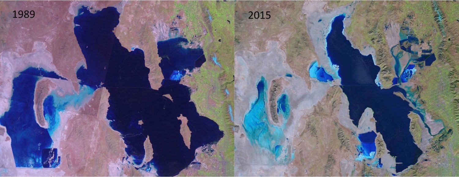
PHOTO CREDIT: McKenzie Skiles via USGS LandSat
The Great Salt Lake has been shrinking as more people use water upstream.
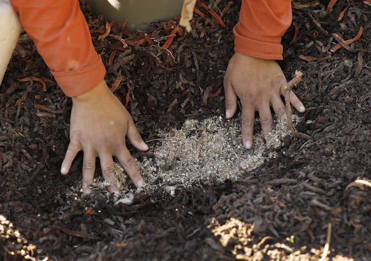
Spring is planting time for home gardeners, landscapers and public works agencies across the U.S. And there’s rising demand for native plants – species that are genetically adapted to the specific regions where they are used.
Native plants have evolved with local climates and soil conditions. As a result, they generally require less maintenance, such as watering and fertilizing, after they become established, and they are hardier than non-native species.
But there’s one big problem: There aren’t enough native seeds. This issue is so serious that it was the subject of a recent report from the National Academies of Sciences, Engineering and Medicine. The study found an urgent need to build a native seed supply.
Many stressors can damage and degrade land. They include natural disasters, such as wildfires and flooding, and human actions, such as urbanization, energy production, ranching and development.
Ecological restoration aims to bring back degraded lands’ native biological diversity and the ecological functions that these areas provided, such as sheltering wildlife and soaking up floodwater. In 2021, the United Nations launched the U.N. Decade on Ecosystem Restoration to promote such efforts worldwide.
Native plants have many features that make them an essential part of healthy ecosystems. For example, they provide long-term defense against invasive and noxious weeds; shelter local pollinators and wildlife; and have roots that stabilize soil, which helps reduce erosion.
Restoration projects require vast quantities of native seeds – but commercial supplies fall far short of what’s needed. Developing a batch of seeds for a specific species takes skill and several years of lead time to either collect native seeds in the wild or grow plants to produce them. Suppliers say one of their biggest obstacles is unpredictable demand from large-scale customers, such as government and tribal agencies, that don’t plan far enough ahead for producers to have stocks ready.
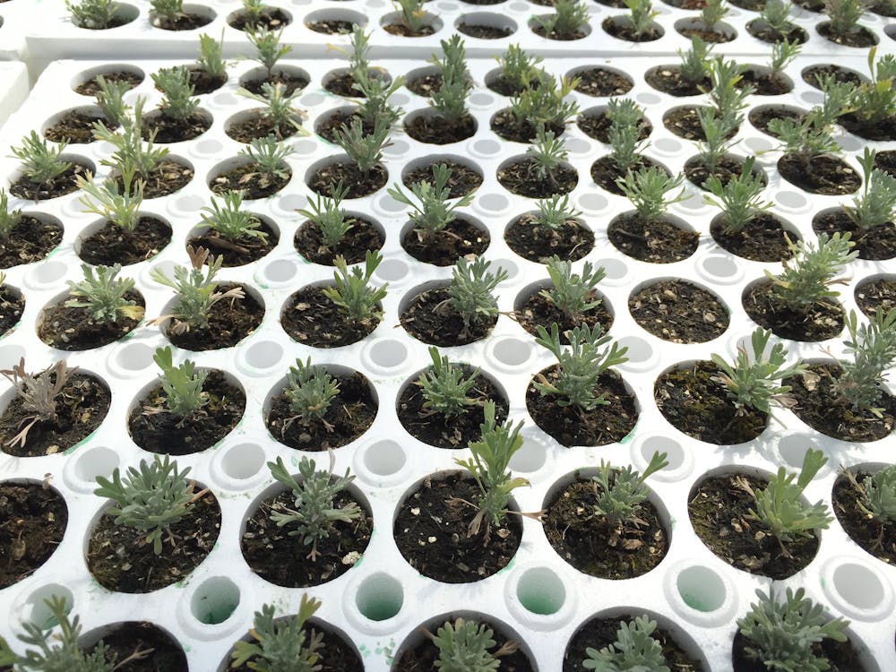
Wyoming Big Sage seedlings growing in a greenhouse. The U.S. Bureau of Land Management and the Shoshone-Paiute Tribe are working together to produce native seedlings to restore public lands in Idaho that have been damaged by wildfires. Bureau of Land Management Idaho/Flickr, CC BY
Restoring roadsides in New England
Most drivers give little thought to what grows next to highways, but the wrong plants in these areas can cause serious problems. Roadsides that aren’t replanted using ecological restoration methods may erode and be taken over by invasive weeds. Ecological restoration provides effective erosion control and better habitat habitats for wildlife and pollinators. It’s also more attractive.
For decades, state transportation departments across the U.S. used non-native cool-season turfgrasses, such as fescue and ryegrass, to restore roadsides. The main benefits of using these species, which grow well during the cooler months of spring and fall, were that they grew fast and provided a quick cover.
Then in 2013 the New England Transportation Consortium – a research cooperative funded by state transportation agencies – commissioned our research team to help the states transition to native warm-season grasses instead. These grasses grow well in hot, dry weather and need less moisture than cool-season grasses. One of us, John Campanelli, developed the framework for selecting plant species based on conservation practices and identified methods for establishing native plant communities for the region.
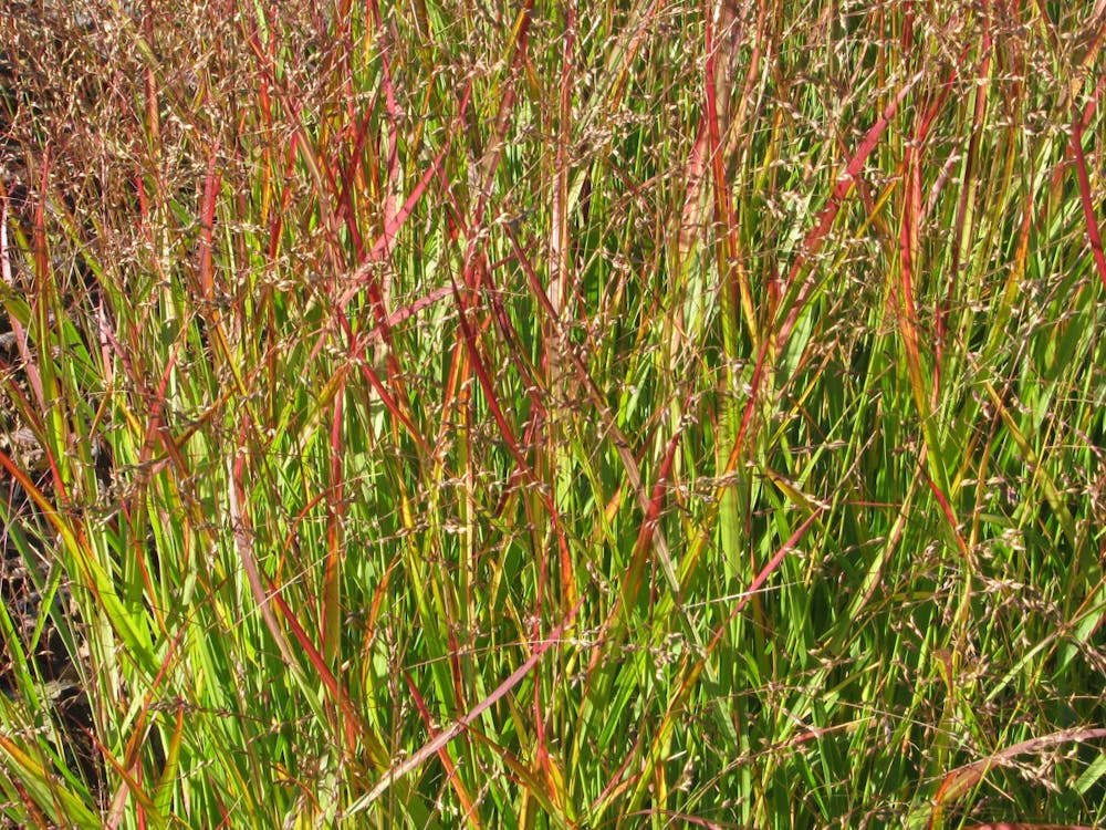
We recommended using warm-season grasses that are native to the region, such as little bluestem, purple lovegrass, switchgrass and purpletop. These species required less long-term maintenance and less-frequent mowing than the cool-season species that agencies had previously used.
To ensure sound conservation practices, we wanted to use seeds produced locally. Seeds sourced from other locations would produce grasses that would interbreed with local ecotypes – grasses adapted to New England – and disrupt the local grasses’ gene complexes.
At that time, however, there was no reliable seed supply for local ecotypes in New England. Only a few sources offered an incomplete selection of small quantities of local seeds, at prices that were too expensive for large-scale restoration projects. Most organizations carrying out ecological restoration projects purchased their bulk seeds mainly from large wholesale producers in the Midwest, which introduced non-local genetic material to the restoration sites.
Improving native seed supply chains
Many agencies are concerned that lack of a local seed supply could limit restoration efforts in New England. To tackle this problem, our team launched a project in 2022 with funding from the New England Transportation Consortium. Our goals are to increase native plantings and pollinator habitats with seeds from local ecotypes, and to make our previous recommendations for roadside restoration with native grasses more feasible.
As we were analyzing ways to obtain affordable native seeds for these roadside projects, we learned about work by Eve Allen, a master’s degree student in city planning at the Massachusetts Institute of Technology. For her thesis, Allen used supply chain management and social network analysis to identify the best methods to strengthen the native seed supply chain network.
Her research showed that developing native seed supplies would require cooperative partnerships that included federal, state and local government agencies and the private and nonprofit sectors. Allen reached out to many of these organizations’ stakeholders and established a broad network. This led to the launch of the regional Northeast Seed Network, which will be hosted by the Massachusetts-based Native Plant Trust, a nonprofit that works to conserve New England’s native plants.
We expect this network will promote all aspects of native seed production in the region, from collecting seeds in the wild to cultivating plants for seed production, developing regional seed markets and carrying out related research. In the meantime, we are developing a road map for new revegetation practices in New England.
We aim to build greater coordination between these agencies and seed producers to promote expanded selections of affordable native seeds and make demand more predictable. Our ultimate goal is to help native plants, bees and butterflies thrive along roads throughout New England.