Breaking down the”breakthrough” #ColoradoRiver deal: It’s big news, but probably won’t be enough to save the river system — @Land_Desk #COriver #aridification #runoff

The Colorado River and the silt flats left behind by a receding Lake Powell. Note the old Hite Marina boat ramp on the left side of the image. This was once at water’s edge. Jonathan P. Thompson photo.

Click the link to read the article on The Land Desk website (Jonathan P. Thompson):

The News: Arizona, California, and Nevada have come up with a landmark agreement to slash their consumption of Colorado River water by 3 million acre-feet in coming years. The Colorado River and its reservoirs are saved!

The Buzzkill: Nope. Not quite.

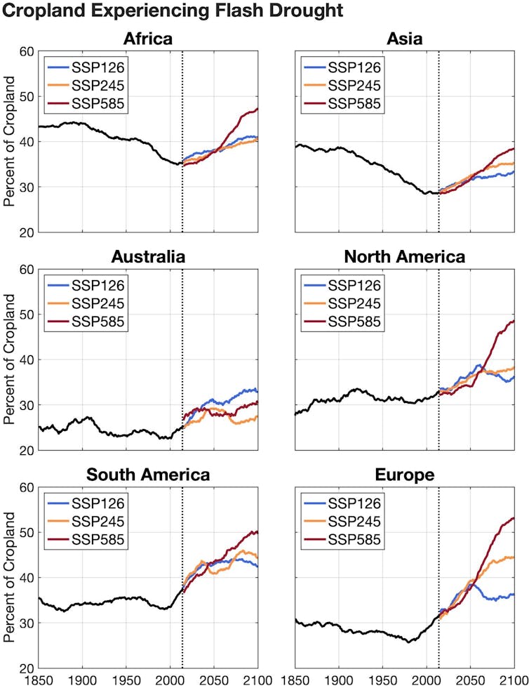
Yes, the three Lower Basin states came up with an agreement to cut water use substantially. Yes, it’s a breakthrough (as any such agreement would be). But no, it won’t be enough to save the Colorado River if the climatic conditions of the last couple decades persist or worsen. Plus, the proposed cuts are only for the next few years. What then?

Map credit: AGU

The Background: For those who may have forgotten, the 1922 Colorado River Compact divvied up the river between the Upper and Lower Basin states (Mexico was included in the 1940s). The problem: The 16.5 million acre-feet pie they parceled out was bigger than what actually existed—even back then. They assumed the river carried about 20 million acre-feet each year, on average. In fact, it was more like 14 million acre-feet, so they were already in debt to reality when the Compact was signed. Oof.

Updated Colorado River 4-Panel plot thru Water Year 2022 showing reservoirs, flows, temperatures and precipitation. All trends are in the wrong direction. Since original 2017 plot, conditions have deteriorated significantly. Brad Udall via Twitter: https://twitter.com/bradudall/status/1593316262041436160

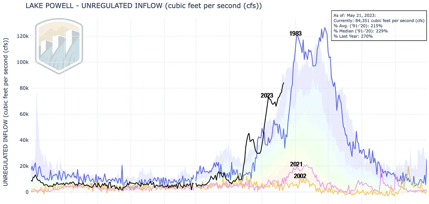
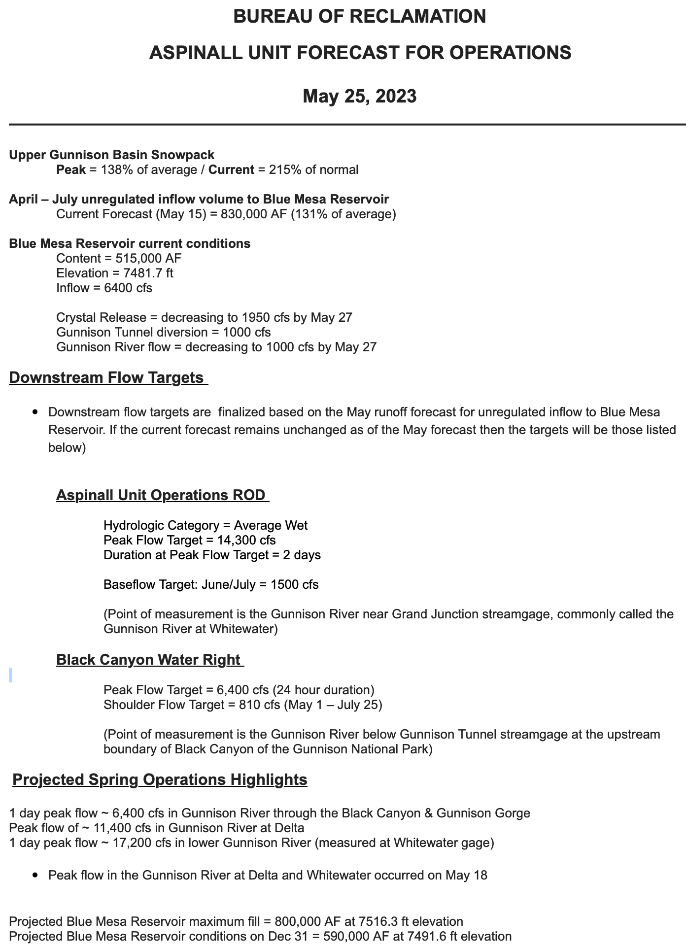
In the decades since, the population of all of the states burgeoned and water consumption also increased. Meanwhile, after the wet and wild 1980s, long-term drought and warmer temperatures diminished the river and the reservoirs that were supposed to carry the users over during dry years. Last summer it looked like Lake Powell might drop below minimum power pool, or the level needed to allow water to flow through the hydroelectricity-generating turbines, within a couple of years. Losing hydropower is one thing, but losing the ability to release water through the penstocks is another, with its own dire ramifications.

That prompted federal water officials to call on the states to cut consumption by 2 million to 4 million acre-feet per year, or else they would implement the cuts themselves. The states blew past deadlines without an agreement until finally, last month, the Bureau of Reclamation presented two alternatives:

  1. Cut Lower Basin use according to the concept of priority (meaning Arizona would take the biggest cuts); or,
The matrix for the Bureau of Reclamation’s priority-based alternative, which would burden Arizona with the biggest cuts and barely lean on California at all. USBR.

2. Cut a flat percentage of each state’s water use (meaning California would take the biggest cuts).

The matrix for the Bureau of Reclamation’s flat percentage-based alternative, which would result in larger volume cuts for California. USBR.

The prospect apparently was enough to scare the bejeezus out of the states, pushing them back to the negotiating table where they came up with this week’s deal. Details so far are sketchy, but here’s what we know:

The Agreement:

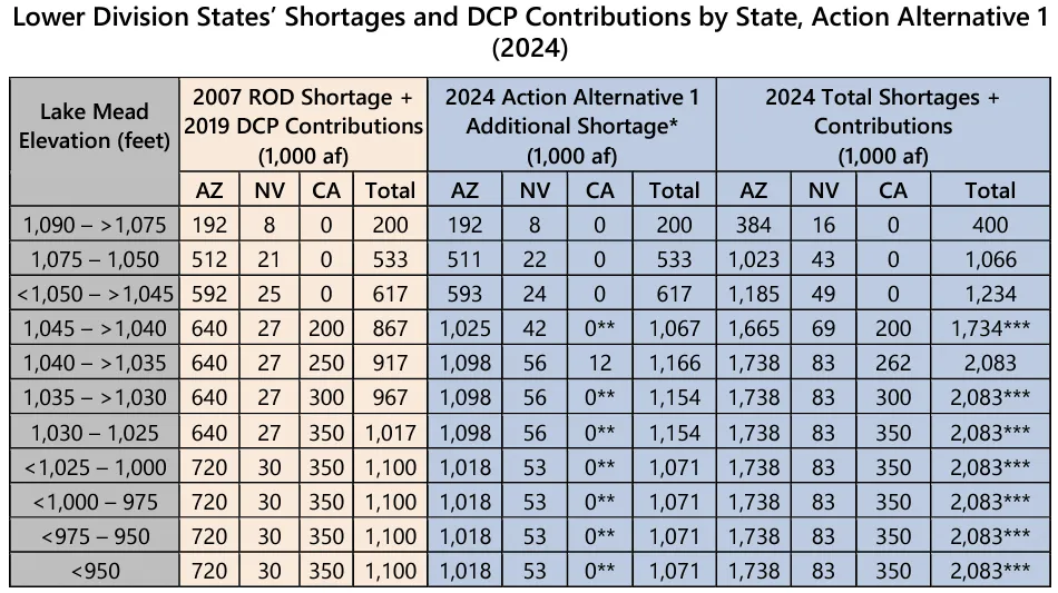
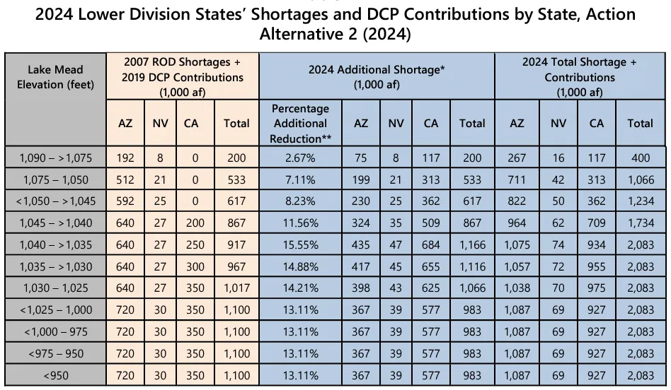
  • The Lower Basin states together will cut consumption by 3 million acre-feet over the 2023-2026 period, with at least 1.5 million acre-feet in cuts coming by the end of 2024 (there is no indication of how these cuts will be distributed across the states, but the Washington Post reports California will bear about half the cuts);
  • Up to 2.3 million acre-feet of those cuts will be federally compensated by about $1.2 billion in Inflation Reduction Act funds. Most likely this means that farmers will be paid not to irrigate their crops.

So what’s wrong with this deal? I’ll admit that when I first read the stories on this, I was pretty damned impressed: 3 million acre-feet is good! Thing is, all those cuts are spread out over three years, meaning it’s only about 1 million acre-feet per year. That’s only half the minimum amount of cuts the feds say are needed to shore up the river system and its reservoirs. It just won’t cut it, so to speak, if the drying trend continues.

Furthermore, the deal clearly is meant only to be temporary — a stopgap, a band-aid — that runs out in three years. What happens then? Even if the agreement were to be extended, where would the billions of dollars come from to keep paying the farmers not to irrigate? What if the Republicans’ obstructive ways nix the payments? And what about the additional 700,000 acre-feet of cuts promised? Where will they come from? Or will that require a whole new round of negotiations?

I don’t want to be a party pooper. It’s great that the states came to an agreement and, yes, it is a solution, of sorts. But it’s not the sustainable, permanent one that’s necessary.

Colorado River from CR-311(?) May 23, 2023.

But who knows? Maybe this past wet winter and huge runoff isn’t an anomaly. Maybe it’s the new normal and big rains and snows will come regularly over the next 20 years, filling up the reservoirs, saturating the soil, and swelling the Colorado River into the muddy monster of yore. Maybe we won’t need these cuts after all. But I sure as heck wouldn’t bank on it.

Big water! That’s what this chart shows in the form of unregulated inflow into Lake Powell. That is an estimate of how much water would be flowing into the reservoir if there were no upstream diversions or dams. The actual inflow is slightly lower (74,000 cfs instead of 84,000), but the patterns are basically the same. Note that 2023’s runoff is bigger even than the monster flows of 1983 — so far. That’s unlikely to continue as the snowpack is melting fast. This also illustrates just how awful 2002 and 2021 were. USBR.

#Runoff and May rains bring high rivers and flood warnings — @AlamosaCitizen #RioGrande #SanLuisValley

San Antonio River May 2023. Photo credit: Alamosa Citizen

Click the link to read the article on the Alamosa Citizen website (Chris Lopez):

HIGH rivers, rising natural surface water in agricultural and livestock fields, country roads washing out – there’s water everywhere across the San Luis Valley.

“We would like to remind people to be aware and prepared for voluntary evacuations if necessary,” Conejos County Sheriff Garth Crowther said in a released statement as Conejos County went under a county flood watch this week.

Both the Rio Grande and Conejos River are running dangerously high and fast. The Rio Grande at the Del Norte gauging station shows a 10-day streamflow average of 4,788 cubic feet per second. The Conejos River, meanwhile, was standing at five feet and the San Antonio River, one of its tributaries east of Manassa along Colorado Highway 142, was flowing at a healthy 1,224 cfs with swampy fields dotting the road to San Luis.

“Still seeing snowpack in the mountains. It feels like it’s going to be a year like we haven’t had in 20 years,” said Rio Grande Water Conservation District General Manager Cleave Simpson.

The month of May has exceeded what’s normal for rain accumulation, with .68 inches of precipitation measured so far. A historically normal May would see a bit over a half-inch of accumulated moisture. 

The May rains timed themselves to healthy spring runoffs across the San Juans, which experienced snowfall totals at 200 percent and above of normal. It’s the San Juans that affect the Upper Rio Grande and Conejos streamflows.

On the recreation front, the expected 200 or so participants in this weekend’s Valley Bottom Rio Trio adventure race will find high water to canoe through on the second leg of the race. It’ll be the strongest and highest streamflow that canoers have had to deal with in the three years of the adventure race.

Minor flooding conditions along the banks of the Rio Grande through Alamosa also had organizers re-route the overall race course.

For Valley residents who may find themselves in flood watch or flood warning conditions, Conejos County offered these tips:

  • Gather emergency supplies, including non-perishable food and water. Store at least 1 gallon of drinking water per day for each person and pet.
  • If it looks like you need to evacuate, turn off all utilities at the main switch and close the main gas valve.
  • Leave areas subject to flooding such as low spots, canyons, washes etc.
Photo credit: Alamosa Citiizen

U.S. Supreme Court guts clean #water protections, putting wetlands, rivers, public health at risk — @AmericanRivers

Wetlands, which are havens of biodiversity, offer priceless ecological benefits. As wetlands are lost to development nationwide, critics of the dam project worry about its local impact. (Photo Credit: John Fielder via Writers on the Range)

Click the link to read the statement on the American Rivers website (Amy Souers Kober):

In today’s [May 25, 2023] ruling on Sackett v. EPA, the Supreme Court dramatically narrowed the scope of the Clean Water Act, undoing protections that have safeguarded the nation’s waters for over 50 years. Because it erases critical protections for tens of millions of acres of wetlands, the court’s ruling threatens the clean drinking water sources for millions of Americans.  

Overturning federal protections for wetlands makes them vulnerable to pollution and harmful development, which impacts water quality, groundwater supplies, flood protection, and habitat for plants, fish, and wildlife. It will also make it more expensive to treat our water, driving up costs for millions of people. The court’s ruling will allow further destruction of wetlands, which will increase the rate and severity of flooding and flood damages in many places. 

Tom Kiernan, President and CEO of American Rivers, made the following statement: 

“The court’s ruling is a serious blow to wetlands, which are essential to clean, affordable drinking water, public health, and flood protection. Today’s ruling puts rivers and people at greater risk from pollution and harm. We urge state officials, the Biden Administration, and Congress to act quickly to safeguard rivers, wetlands, and streams that are so vital to our health and safety, environment, and economy. Rivers should unite us, not divide us.” 

“Without strong, science-based protections, the rivers and wetlands that are the lifeblood of our nation will suffer irreparable harm. We risk going backwards to a time of beach closures and rivers choked with pollution. This ruling will exacerbate environmental injustices as the worst impacts harm communities of color. American Rivers will continue to stand with local partners and frontline communities to secure equitable protections for rivers and clean water nationwide. ” 

Farmers face a soaring risk of flash droughts in every major food-growing region in coming decades, new research shows

A flash drought in 2012 dried out soil, harming crops in Kansas and several other states. John Moore/Getty Images

Jeff Basara, University of Oklahoma and Jordan Christian, University of Oklahoma

Flash droughts develop fast, and when they hit at the wrong time, they can devastate a region’s agriculture.

They’re also becoming increasingly common as the planet warms.

In a new study published May 25, 2023, we found that the risk of flash droughts, which can develop in the span of a few weeks, is on pace to rise in every major agriculture region around the world in the coming decades.

In North America and Europe, cropland that had a 32% annual chance of a flash drought a few years ago could have as much as a 53% annual chance of a flash drought by the final decades of this century. The result would put food production, energy and water supplies under increasing pressure. The cost of damage will also rise. A flash drought in the Dakotas and Montana in 2017 caused US$2.6 billion in agricultural damage in the U.S. alone.

A dry field of short, sad looking corn stalks with a farm with cattle in the background.
Stunted corn in Nebraska struggles to grow during the 2012 flash drought that covered much of the central U.S. AP Photo/Nati Harnik

How flash droughts develop

All droughts begin when precipitation stops. What’s interesting about flash droughts is how fast they reinforce themselves, with some help from the warming climate.

When the weather is hot and dry, soil loses moisture rapidly. Dry air extracts moisture from the land, and rising temperatures can increase this “evaporative demand.” The lack of rain during a flash drought can further contribute to the feedback processes.

Under these conditions, crops and vegetation begin to die much more quickly than they do during typical long-term droughts.

Global warming and flash droughts

In our new study, we used climate models and data from the past 170 years to gauge the drought risks ahead under three scenarios for how quickly the world takes action to slow global warming.

If greenhouse gas emissions from vehicles, power plants and other human sources continue at a high rate, we found that cropland in much of North America and Europe would have a 49% and 53% annual chance of flash droughts, respectively, by the final decades of this century. Globally, the largest projected increases would be in Europe and the Amazon.

Slowing emissions can reduce the risk significantly, but we found flash droughts would still increase by about 6% worldwide under a low-emissions scenario.

Charts show the amount of cropland experiencing flash droughts today in Africa, Asia, Australia, North America, South America and Europe, and project how flash drought exposure will increase based on greenhouse gas emissions that drive global warming.
Climate models indicate that more land will be in flash drought in every region in the coming decades. Three scenarios show how low (SSP126), medium (SSP245) and high (SSP585) emissions are likely to affect the amount of land in flash drought. In some regions, rising global emissions will bring more extreme rainfall, offsetting drought. Jordan Christian

Timing is everything for agriculture

We’ve lived through a number of flash drought events, and they’re not pleasant. People suffer. Farmers lose crops. Ranchers may have to sell off cattle. In 2022, a flash drought slowed barge traffic on the Mississippi River, which carries more than 90% of U.S. agriculture exports.

If a flash drought occurs at a critical point in the growing season, it could devastate an entire crop.

Corn, for example, is most vulnerable during its flowering phase, called silking. That typically happens in the heat of summer. If a flash drought occurs then, it’s likely to have extreme consequences. However, a flash drought closer to harvest can actually help farmers, as they can get their equipment into the fields more easily.

A line of houseboats that once floated on a river sit in puddles on the nearly dry riverbed during a flash drought.
During Europe’s flash drought in 2022, floating houses were left sitting on a dry riverbed in the Netherlands. Thierry Monasse/Getty Images

In the southern Great Plains, winter wheat is at its highest risk during seeding, in September to October the year before the crop’s spring harvest. When we looked at flash droughts in that region during that fall seeding period, we found greatly reduced yields the following year.

Looking globally, paddy rice, a staple for more than half the global population, is at risk in northeast China and other parts of Asia. Other crops are at risk in Europe.

Ranches can also be hit hard by flash droughts. During the huge flash drought in 2012 in the central U.S., cattle ran out of forage and water became scarcer. If rain doesn’t fall during the growing season for natural grasses, cattle don’t have food, and ranchers may have little choice but to sell off part of their herds. Again, timing is everything.

It’s not just agriculture. Energy and water supplies can be at risk, too. Europe’s intense summer drought in 2022 started as a flash drought that became a larger event as a heat wave settled in. Water levels fell so low in some rivers that power plants shut down because they couldn’t get water for cooling, compounding the region’s problems. Events like those are a window into what countries are already facing and could see more of in the future.

Not every flash drought will be as severe as what the U.S. and Europe saw in 2012 and 2022, but we’re concerned about what may be ahead. https://cdn.knightlab.com/libs/juxtapose/latest/embed/index.html?uid=a0dbaece-fa44-11ed-b5bd-6595d9b17862 A flash drought developed in the span of a few weeks in 2019. NASA Earth Observatory

Can agriculture adapt?

One way to help agriculture adapt to the rising risk is to improve forecasts for rainfall and temperature, which can help farmers as they make crucial decisions, such as whether they’ll plant or not.

When we talk with farmers and ranchers, they want to know what the weather will look like over the next one to six months. Meteorology is pretty adept at short-term forecasts that look out a couple of weeks, and at longer-term climate forecasts using computer models. But flash droughts evolve in a midrange window of time that is difficult to forecast.

We’re tackling the challenge of monitoring and improving the lead time and accuracy of forecasts for flash droughts, as are other scientists. For example, the United States Drought Monitor has developed an experimental short-term map that can display developing flash droughts. As scientists learn more about the conditions that cause flash droughts and about their frequency and intensity, forecasts and monitoring tools will improve.

Increasing awareness can also help. If short-term forecasts show that an area is not likely to get its usual precipitation, that should immediately set off alarm bells. If forecasters are also seeing the potential for increased temperatures, that heightens the risk for a flash drought’s developing.

Nothing is getting easier for farmers and ranchers as global temperatures rise. Understanding the risk from flash droughts will help them, and anyone concerned with water resources, manage yet another challenge of the future.

Jeff Basara, Associate Professor of Meteorology, University of Oklahoma and Jordan Christian, Postdoctoral Researcher in Meteorology, University of Oklahoma

This article is republished from The Conversation under a Creative Commons license. Read the original article.

Aspinall Unit forecast for operations May 25, 2023 #GunnisonRiver #ColoradoRiver #COriver #aridification #runoff

From email from Reclamation (Erik Knight):

#Greeley #water officials declare adequate water year — The Greeley Tribune #runoff

Seaman Reservoir upstream of confluence of the North Fork of the Cache la Poudre River. Photo credit Greg Hobbs.

Click the link to read the article on The Greeley Tribune website (Trevor Reid). Here’s an excerpt:

Greeley residents can continue watering their lawns, gardens and outdoor landscapes under normal watering rules through Oct. 31, thanks to the declaration of an adequate water year by the city’s Water and Sewer Board this past month. Above-average snowpack and low temperatures in the high mountains have helped the mountains maintain the snowpack before it melts and feeds the rivers. Recent rainstorms have caused river flows to increase, according to a city news release. The city’s water resources confirmed the city’s reservoirs are either full or filling, with Cache la Poudre and Big Thompson runoff peaking in early June…

Given the adequate water year, the city will also continue its water rental program, renting excess water to farmers and ranchers. Excess water may be rented out so long as the target storage volume of 21,300 acre-feet is maintained. Depending on snowmelt and river conditions, the city may rent out additional water after the initial April allocation…The city averages 6.41 inches of precipitation each year through May 21, according to a city news release. As of earlier this week, the city received 8.03 inches of rainfall — 1.6 inches above average.