The U.S. Supreme Court just shriveled federal protection for #wetlands, leaving many of these valuable ecosystems at risk — The Conversation

Many ecologically important wetlands, like these in Kulm, N.D., lack surface connections to navigable waterways. USFWS Mountain-Prairie/Flickr, CC BY

Albert C. Lin, University of California, Davis

The U.S. Supreme Court has ruled in Sackett v. EPA that federal protection of wetlands encompasses only those wetlands that directly adjoin rivers, lakes and other bodies of water. This is an extremely narrow interpretation of the Clean Water Act that could expose many wetlands across the U.S. to filling and development.

Under this keystone environmental law, federal agencies take the lead in regulating water pollution, while state and local governments regulate land use. Wetlands are areas where land is wet for all or part of the year, so they straddle this division of authority.

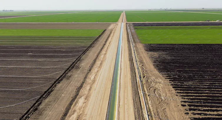
Swamps, bogs, marshes and other wetlands provide valuable ecological services, such as filtering pollutants and soaking up floodwaters. Landowners must obtain permits to discharge dredged or fill material, such as dirt, sand or rock, in a protected wetland.

This can be time-consuming and expensive, which is why the Supreme Court’s ruling on May 25, 2023, will be of keen interest to developers, farmers and ranchers, along with conservationists and the agencies that administer the Clean Water Act – namely, the Environmental Protection Agency and the U.S. Army Corps of Engineers.

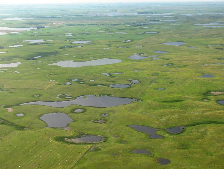
For the last 45 years – and under eight different presidential administrations – the EPA and the Corps have required discharge permits in wetlands “adjacent” to water bodies, even if a dune, levee or other barrier separated the two. The Sackett decision upends that approach, leaving tens of millions of acres of wetlands at risk. https://www.youtube.com/embed/bFGMoFIjKRM?wmode=transparent&start=1 The U.S. has lost more than half of its original wetlands, mainly due to development and pollution.

The Sackett case

Idaho residents Chantell and Mike Sackett own a parcel of land located 300 feet from Priest Lake, one of the state’s largest lakes. The parcel once was part of a large wetland complex. Today, even after the Sacketts cleared the lot, it still has some wetland characteristics, such as saturation and ponding in areas where soil was removed. Indeed, it is still hydrologically connected to the lake and neighboring wetlands by water that flows at a shallow depth underground.

In preparation to build a house, the Sacketts had fill material placed on the site without obtaining a Clean Water Act permit. The EPA issued an order in 2007 stating that the land contained wetlands subject to the law and requiring the Sacketts to restore the site. The Sacketts sued, arguing that their property was not a wetland.

In 2012, the Supreme Court held that the Sacketts had the right to challenge EPA’s order and sent the case back to the lower courts. After losing below on the merits, they returned to the Supreme Court with a suit asserting that their property was not federally protected. This claim in turn raised a broader question: What is the scope of federal regulatory authority under the Clean Water Act?

Homes line the edges of a river.
Housing encroaches on Caloosahatchee River wetlands in Fort Myers, Fla. Jeffrey Greenberg/Universal Images Group via Getty Images

What are ‘waters of the United States’?

The Clean Water Act regulates discharges of pollutants into “waters of the United States.” Lawful discharges may occur if a pollution source obtains a permit under either Section 404 of the act for dredged or fill material, or Section 402 for other pollutants.

The Supreme Court has previously recognized that the “waters of the United States” include not only navigable rivers and lakes, but also wetlands and waterways that are connected to navigable bodies of water. But many wetlands are not wet year-round, or are not connected at the surface to larger water systems. Still, they can have important ecological connections to larger water bodies.

In 2006, when the court last took up this issue, no majority was able to agree on how to define “waters of the United States.” Writing for a plurality of four justices in U.S. v. Rapanos, Justice Antonin Scalia defined the term narrowly to include only relatively permanent, standing or continuously flowing bodies of water such as streams, oceans, rivers and lakes. Waters of the U.S., he contended, should not include “ordinarily dry channels through which water occasionally or intermittently flows.”

Acknowledging that wetlands present a tricky line-drawing problem, Scalia proposed that the Clean Water Act should reach “only those wetlands with a continuous surface connection to bodies that are waters of the United States in their own right.”

In a concurring opinion, Justice Anthony Kennedy took a very different approach. “Waters of the U.S.,” he wrote, should be interpreted in light of the Clean Water Act’s objective of “restoring and maintaining the chemical, physical, and biological integrity of the Nation’s waters.”

Accordingly, Kennedy argued, the Clean Water Act should cover wetlands that have a “significant nexus” with navigable waters – “if the wetlands, either alone or in combination with similarly situated lands in the region, significantly affect the chemical, physical, and biological integrity of other covered waters more readily understood as ‘navigable.’”

Neither Scalia’s nor Kennedy’s opinion attracted a majority, so lower courts were left to sort out which approach to follow. Most applied Kennedy’s significant nexus standard, while a few held that the Clean Water Act applies if either Kennedy’s standard or Scalia’s is satisfied.

Regulators have also struggled with this question. The Obama administration incorporated Kennedy’s “significant nexus” approach into a 2015 rule that followed an extensive rulemaking process and a comprehensive peer-reviewed scientific assessment. The Trump administration then replaced the 2015 rule with a rule of its own that largely adopted the Scalia approach.

The Biden administration responded with its own rule defining waters of the United States in terms of the presence of either a significant nexus or continuous surface connection. However, this rule was promptly embroiled in litigation and will require reconsideration in light of Sackett v. EPA.

The Sackett decision and its ramifications

The Sackett decision adopts Scalia’s approach from the 2006 Rapanos case. Writing for a five-justice majority, Justice Samuel Alito declared that “waters of the United States” includes only relatively permanent, standing or continuously flowing bodies of water, such as streams, oceans, rivers, lakes – and wetlands that have a continuous surface connection with and are indistinguishably part of such water bodies.

None of the nine justices adopted Kennedy’s 2006 “significant nexus” standard. However, Justice Brett Kavanaugh and the three liberal justices disagreed with the majority’s “continuous surface connection” test. That test, Kavanaugh wrote in a concurrence, is inconsistent with the text of the Clean Water Act, which extends coverage to “adjacent” wetlands – including those that are near or close to larger water bodies.

“Natural barriers such as berms and dunes do not block all water flow and are in fact evidence of a regular connection between a water and a wetland,” Kavanaugh explained. “By narrowing the Act’s coverage of wetlands to only adjoining wetlands, the Court’s new test will leave some long-regulated adjacent wetlands no longer covered by the Clean Water Act, with significant repercussions for water quality and flood control throughout the United States.”

The majority’s ruling leaves little room for the EPA or the Army Corps of Engineers to issue new regulations that could protect wetlands more broadly.

The court’s requirement of a continuous surface connection means that federal protection may no longer apply to many areas that critically affect the water quality of U.S. rivers, lakes and oceans – including seasonal streams and wetlands that are near or intermittently connected to larger water bodies. It might also mean that construction of a road, levee or other barrier separating a wetland from other nearby waters could remove an area from federal protection.

Congress could amend the Clean Water Act to expressly provide that “waters of the United States” includes wetlands that the court has now stripped of federal protection. However, past efforts to legislate a definition have fizzled, and today’s closely divided Congress is unlikely to fare any better.

Whether states will fill the breach is questionable. Many states have not adopted regulatory protections for waters that are outside the scope of “waters of the United States.” In many instances, new legislation – and perhaps entirely new regulatory programs – will be needed.

Finally, a concurring opinion by Justice Clarence Thomas hints at potential future targets for the court’s conservative supermajority. Joined by Justice Neil Gorsuch, Thomas suggested that the Clean Water Act, as well as other federal environmental statutes, lies beyond Congress’ authority to regulate activities that affect interstate commerce, and could be vulnerable to constitutional challenges. In my view, Sackett v. EPA might be just one step toward the teardown of federal environmental law.

This is an update of an article originally published on Sept. 26, 2022.

Albert C. Lin, Professor of Law, University of California, Davis

This article is republished from The Conversation under a Creative Commons license. Read the original article.

Deadpool Diaries: The Case for a Shitty Deal — John Fleck (InkStain) #ColoradoRiver #COriver #aridification

The Lower Basin “structural deficit”, reified. Maybe if Lake Mead rises enough this year the boats will be back underwater and we can stop worrying about deadpool. Photo credit: John Fleck

Click the link to read the article on the InkStain website (John Fleck):

I’ve had long conversations this week with smart friends grudgingly supporting of the Lower Basin deal to reduce Colorado River water use over the next few years. Their case for it is simple. Yes, it’s an awful deal in so many ways, but it does have the potential to generate some short term water use reductions and cut the red wire on the ticking time bomb.

SNWA’s John Entsminger made the case this way in an interview Monday with Colton Lochhead at the Las Vegas Review Journal:

My friends making this argument have a crucial credential that I don’t have in making their “sure whatever, it’s terrible but let’s just smile politely and get on with things” argument: they have been or are in the room for negotiations like this. I’m just heckling from the cheap seats.

YAY SAVINGS!

The best thing about the deal is an apparent commitment (see below for my reasons for italicizing) to deeper reductions in Lower Basin water use than folks down at that end of the system have been willing to agree to in the past. Three million new acre feet of savings above and beyond what has already been agreed to falls well short of the two to four million acre feet Reclamation Commissioner Camille Touton told us last year would be needed, but with a big snowpack the numbers have changed.

BUT THE SAVINGS FALL SHORT OF WHAT WE KNOW IS NEEDED

It’s been clear for as long as I’ve been writing seriously about the Colorado River that, if the Upper Basin meets its (contested) Lee Ferry delivery obligation, the Lower Basin needs to cut 1.2 million to 1.5 million acre feet per year. Permanently. Three million acre feet from 2023-26 falls well short of that.

For more than two decades, the Lower Basin has been dithering over how to make the cuts and in the meantime draining the reservoir, essentially building the time bomb that we’re now trying to defuse.

To be clear, enormous progress has been made in the last two decades to build the necessary institutional widgets to bring the system into balance.I wrote a whole book about it! My purpose in writing the book was to build a case for three things:

  • that fears communities often have about the impact of water reductions are misplaced – that we can all get by with less water
  • that successful institutional widgets had been built based on collaboration and sharing that could allow us to adapt
  • that a lot more work was needed to cut far more deeply than we had by the time I handed in the book’s manuscript in December 2015

But in the midst of crisis, and with a ticking bomb, we still haven’t been able to come up with even the bare minimum that we’ve all known for decades that we need in Lower Basin cuts.

WE DON’T ACTUALLY KNOW WHAT THE DEAL IS

What we’ve got at this point documenting the deal is a “term sheet” and a round of celebratory press releases. We have no official breakdown of the makeup of the 3 million acre feet – what’s California’s share, Nevada’s, Arizona’s – how much is Imperial and Metropolitan and Palo Verde, how much is CAP and Yuma. We’ve got individual state reps telling reporters (shout out to my friends in the fourth estate for trying to push down the path of actually breaking down the numbers). But that’s not the same thing as all of us being able to look at it in writing rather than passing around news site links, to be interpreted like fragments of a Dead Sea scroll.

The deal at this point is a pile of stuff shrouded in a tarp that we’re not allowed to peak under. We’ve just gotta trust the Lower Basin folks that they’ll actually come up with the water.

The reason, as one of my smart “been-in-the-room-where-it-happens” friends pointed out, is that the actual detailed reductions will need to go before the boards of a bunch of water agencies. Which hasn’t happened yet. Which means there are umpty reasons for this to spin out of control.

It crucially depends on federal money flowing to water users to compensate them for water they don’t use, but as Janet Wilson pointed out this week in the Desert Sun, we’ve already missed the chance to save some of that water this year because of bureaucratic stuff. That process is not going well.

We all remember the ducking and diving around the celebrated “500 Plus Plan”. Know, those of you who know what’s under the tarp, why those of us who don’t are legitimately nervous about your approach to cutting the red wire.

So spare me the celebratory press releases and puff pieces about politicians breaking roadblocks.

YO, UPPER BASIN HERE, REMEMBER US?

The “seven state letter” is comical, but also revealing.

One imagines federal officials desperate to somehow fly a seven-state flag over the deal, and the last-minute phone calls and emails over the weekend aimed at drafting a letter that says something.

At this point, Upper Basin communities (That’s me! Hi!) are just hostages in the next room, unable to help defuse the bomb and hoping y’all down there can figure out how to cut the right wire.

It’s even worse that y’all in the Lower Basin are demanding that the federal taxpayers kick in a billion dollars or you won’t cut any wire at all.

WAIT. WHICH WIRE WAS IT WE WERE SUPPOSED TO CUT?

Oh shit. Was it the red wire we were supposed to cut? The blue one?

Colorado River “Beginnings”. Photo: Brent Gardner-Smith/Aspen Journalism

U.S. Supreme Court Limits E.P.A.’s Power to Address Water Pollution — The New York Times

The Wood River Wetland in southern Oregon is home to an array of biodiverse vegetation and is a freshwater ecoregion. Photo credit: Bureau of Land Management

Click the link to read the article on The New York Times website (Adam Liptak). Here’s an excerpt:

Experts in environmental law said the decision would leave many wetlands subject to pollution without penalty, sharply undercutting the E.P.A.’s authority to protect them under the Clean Water Act…Kevin Minoli, who worked as a senior E.P.A. lawyer from the Clinton through the Trump administrations, overseeing the enforcement of Clean Water Act regulations, said the decision would have enormous practical consequences and estimated that it would affect more than half the nation’s wetlands…

The decision was nominally unanimous, with all the justices agreeing that the homeowners who brought the case should not have been subject to the agency’s oversight because the wetlands on their property were not subject to regulation in any event. But there was sharp disagreement about a new test the majority established to determine which wetlands are covered by the law. Justice Brett M. Kavanaugh, joined by the three liberal justices in a concurring opinion, said the decision would harm the federal government’s ability to address pollution and flooding.

“By narrowing the act’s coverage of wetlands to only adjoining wetlands,” he wrote, “the court’s new test will leave some long-regulated adjacent wetlands no longer covered by the Clean Water Act, with significant repercussions for water quality and flood control throughout the United States.”

[…]

“There,” she wrote, “the majority’s non-textualism barred the E.P.A. from addressing climate change by curbing power plant emissions in the most effective way. Here, that method prevents the E.P.A. from keeping our country’s waters clean by regulating adjacent wetlands. The vice in both instances is the same: the court’s appointment of itself as the national decision maker on environmental policy.”

Colorado River states bought time with a 3-year water conservation deal – now they need to think bigger

An irrigation canal moves Colorado River water through farm fields in California’s Imperial Valley. Photo by Sandy Huffaker / AFP via Getty Images

Robert Glennon, University of Arizona

Arizona, California and Nevada have narrowly averted a regional water crisis by agreeing to reduce their use of Colorado River water over the next three years. This deal represents a temporary solution to a long-term crisis. Nonetheless, as a close observer of western water policy, I see it as an important win for the region.

Seven western states – Colorado, Wyoming, Utah, New Mexico, Arizona, Nevada and California – and Mexico rely on water from the Colorado River for irrigation for 5.5 million acres and drinking water for 40 million people. Their shares are apportioned under a compact negotiated in 1922. We now know, thanks to tree-ring science, that its framers wildly overestimated how much water the river contained on a reliable basis. And climate change is making things worse.

Some recent commentators have argued for revamping the compact. The lawyer in me shudders to think of the utter chaos that would ensue as states, tribes that were left out of the original agreement, and Mexico try to unwind settled expectations and create new ones.

In my view, the agreement announced on May 22, 2023, strongly repudiates the need to revamp the compact. Seven states were able to finesse an agreement that will ultimately result in significant changes to the legal documents collectively known as the Law of the River, without the need to begin again. The next step – a broader, longer-lasting overhaul of the compact – will be even more challenging. https://www.youtube.com/embed/-xTv3xYx8b4?wmode=transparent&start=0 The May 2023 deal staves off an immediate water crisis but does not solve long-term problems in the Colorado River Basin.

Overallocated and shrinking

The Colorado River, the lifeblood of the U.S. Southwest, faced the prospect of going dry if its two largest reservoirs – Lakes Mead and Powell – hit dead pool, the level at which no water flows through their dams. Several forces led to this catastrophic prospect.

First, the 1922 Colorado River Compact and other elements of the Law of the River dole out rights to more water than the river provides.

Second, a historic drought that commenced in 2000 has caused water levels in the reservoirs to plummet by 75%.

Third, climate change has reduced the flow in the river by more than 1 million acre-feet. (One acre-foot is the amount of water required to cover an acre of land to a depth of 1 foot – about 325,000 gallons.) Evaporation off the surface of the reservoirs annually claims in excess of an additional 1 million acre-feet. https://cdn.knightlab.com/libs/juxtapose/latest/embed/index.html?uid=562fd2cc-fb2c-11ed-b5bd-6595d9b17862 These satellite images show water levels declining from 2020 through 2022 in Lake Mead, located in the Mojave Desert in Arizona and Nevada (move slider to see change).NASA Earth Observatory

This year’s snowpack, historic by any measure, offers a year or two of relief from hitting dead pool. However, one wet year doesn’t alter the trajectory of climate change or the level of reliable flows in the river over time.

State water managers clearly understand the problem and have taken significant but insufficient steps to conserve water. Each state thinks the others should do more to solve the problem. Negotiations, sometimes acrimonious, have stalled.

In 2022, the U.S. Department of the Interior broke this stalemate with a plea and then a demand for the states to do more, faster, to protect the river. Then, in April 2023, the agency released a draft supplemental environmental impact study that offered two alternatives – one more favorable to California, the other to Arizona. The message to states was clear: If you can’t reach a consensus, we’ll act to protect the river. Intense negotiations followed, leading to the May 22 agreement.

Will payments promote long-term conservation?

The new cuts center on California, Nevada and Arizona because they draw their shares of the river mostly from Lake Powell and Lake Mead. The states have agreed to reduce their consumption of Colorado River water by 3 million acre-feet by 2026, which represents about 14% of their combined allocations.

This pact temporarily protects water supplies for cities, farmers and tribes. The U.S. Bureau of Reclamation immediately accepted the proposal and committed to pay for steps that are expected to conserve 2.3 million acre-feet of water with money from the Inflation Reduction Act. For example, the Gila River Indian Community will receive $50 million from the Lower Colorado River Basin System Conservation and Efficiency Program in each of the next three years for improvements such as new pipelines.

It’s now up to California, Nevada and Arizona to divvy up the remaining 700,000 acre-feet of cuts. I expect that water reallocation, with water moving from lower-value to higher-value uses, will play a key role. Water marketing – negotiating voluntary sales or leases of water – is a tool to facilitate that transition.

Most of the water involved in the recent agreement will be freed up by one party paying another party to use less – for example, cities paying farmers to conserve water that the cities can then use. That’s the essence of water marketing. The agreement will provide funding to irrigation districts, tribes and water providers, who will then figure out how to generate the savings each organization has committed to deliver.

Negotiation, not litigation

The next steps are for the states to begin discussions about replacing guidelines that currently govern the sharing of Colorado River water, which expire in 2026. These discussions will be more painful because federal funding will expire and cuts will be more severe. Thus far, the Upper Basin states – Wyoming, Colorado, Utah and New Mexico – have not had to endure significant water use cuts. My hope is that the states will seize this three-year window as an opportunity to develop procedures and identify funding for major water reallocations.

Over the last couple of years, there have been threats to solve these issues in court. But litigation is a lengthy, costly process fraught with uncertainty. The original Arizona v. California suit was filed in 1930, and the Supreme Court did not enter its final decree until 2006.

Many legal arguments that individual basin states could present to a court rest on interpretations of vague or ambiguous Law of the River documents. The river can’t wait for the legal process to adjudicate gnarly, complicated claims made trickier by a century of statutory and case law embellishments. As I see it, negotiation and concessions leading to consensus are the only viable solution going forward.

Robert Glennon, Regents Professor Emeritus and Morris K. Udall Professor of Law & Public Policy Emeritus, University of Arizona

This article is republished from The Conversation under a Creative Commons license. Read the original article.

How will #ElNino likely impact rainfall patterns around the world? There’s a map for that — IRI @climatesociety #ENSO

El Niño and rainfall. Credit: IRI May 26, 2023

More information here: https://iridl.ldeo.columbia.edu/maproom/IFRC/FIC/elninorain.html