
Day: May 9, 2023
U.S. dominated by remarkable warmth so far in 2023: 7 separate billion-dollar disasters have struck the nation — NOAA
Click the link to read the article on the NOAA website (John Bateman):
So far, 2023 stands out for the remarkable warmth that covered many parts of the U.S., with some states seeing their warmest January–April period on record.
The first four months of the year have also been marked by seven separate billion-dollar disasters that have struck the nation, according to scientists from NOAA’s National Centers for Environmental Information.
Below are more takeaways from NOAA’s latest monthly U.S. climate report:
Climate by the numbers
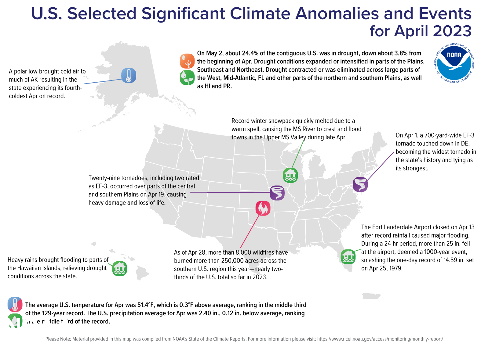
April 2023
The average April temperature across the contiguous U.S. was 51.4 degrees F (0.3 of a degree above the 20th-century average), ranking the month in the middle third of the 129-year climate record.
Maryland and Delaware ranked second warmest on record for April while New Jersey ranked third warmest on record. Connecticut, Florida, Massachusetts, New Hampshire, New York, Pennsylvania, Rhode Island, Vermont and Virginia each saw their top-10 warmest Aprils on record.
Conversely, below-average temperatures covered the Northwest to the central Rockies and northern Plains, and parts of the southern Plains. North Dakota ranked 10th coldest on record for the month.
The average precipitation for the month was 2.40 inches — 0.12 of an inch below average, which places the month in the middle third of the historical record.
Arizona, Missouri, Nebraska and New Mexico saw their third-to-sixth driest Aprils on record, respectively. Meanwhile, Delaware ranked seventh wettest, North Carolina eighth wettest and New Jersey saw its 10th-wettest April on record.
Year to date | January through April 2023
The average U.S. temperature for the year to date (YTD) was 40.9 degrees F (1.8 degrees above average), ranking in the warmest third of the climate record.
Delaware, Florida, Maryland, New Jersey, North Carolina, Pennsylvania and Virginia each had their warmest January–April YTD on record. Connecticut, Massachusetts, New Hampshire, New York, Rhode Island, South Carolina and West Virginia each had their second-warmest such YTD, while 14 additional states ranked among their warmest 10 January-to-April periods on record.
The average precipitation for the first four months of 2023 was 10.22 inches (0.74 of an inch above normal), ranking in the wettest third of the January–April record.
Wisconsin saw its wettest such YTD on record, while Michigan ranked fourth wettest and Utah ranked seventh wettest. On the dry side, Maryland ranked 13th driest on record for this four-month period.
Other notable climate events in this report
Seven separate billion-dollar disasters struck this year: Through the end of April 2023, the U.S. was struck with seven separate weather and climate disasters, each with losses exceeding $1 billion, including:
- Five severe weather events.
- A Northeastern winter storm/cold wave.
- A California flooding event.
The total cost of these events exceeds $19 billion and resulted in 97 direct and indirect fatalities. The number of billion dollar disasters so far in 2023 is significant. Only 2017 and 2020 had more during this timeframe, with eight separate disasters recorded in the January-April period.
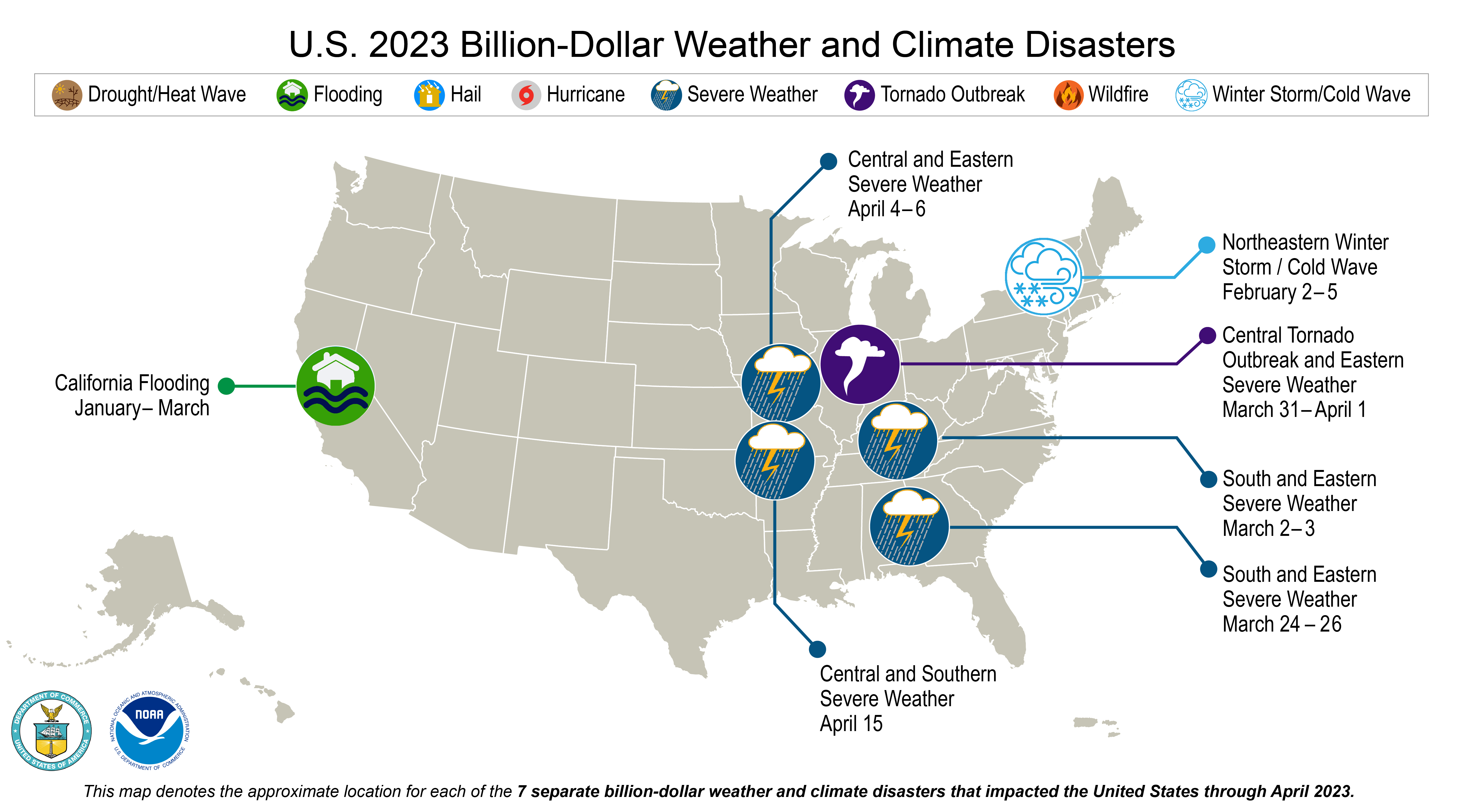
An active severe weather month: Several notable weather systems produced severe thunderstorms and a number of tornadoes that impacted portions of the U.S. in April 2023:
- April 1: A 700-yard-wide EF-3 tornado that touched down in Delaware was the widest tornado in the state’s history. The same tornado was equal in strength to one that struck Delaware on April 28, 1961— the strongest tornadoes recorded in the state.
- April 19: A tornado outbreak occurred across areas of the southern and central Plains. A total of 29 tornadoes, including two EF-3 tornadoes, was confirmed by the National Weather Service, causing heavy damage and loss of life.
- April 30: A state of emergency was declared after a rare EF-3 tornado touched down in Virginia Beach, destroying more than 100 structures.
Parts of Florida inundated with flooding: In less than a 24-hour period, more than 25 inches of rain fell at the Fort Lauderdale Airport on April 13. The event, deemed a 1,000-year event by the National Weather Service, smashed the previous one-day record of 14.59 inches of rain set on April 25, 1979.
Flooding puts parts of #Parachute underwater: #ParachuteCreek as high as it’s been since 1976, city reports — The #GlenwoodSprings Post Independent #runoff

Click the link to read the release from the Town of Parachute on the Glenwood Springs Post Independent website (Ray K. Erku). Here’s an excerpt:
Waters from a creek in Parachute continue to rise and threaten nearby residences, a town official said.
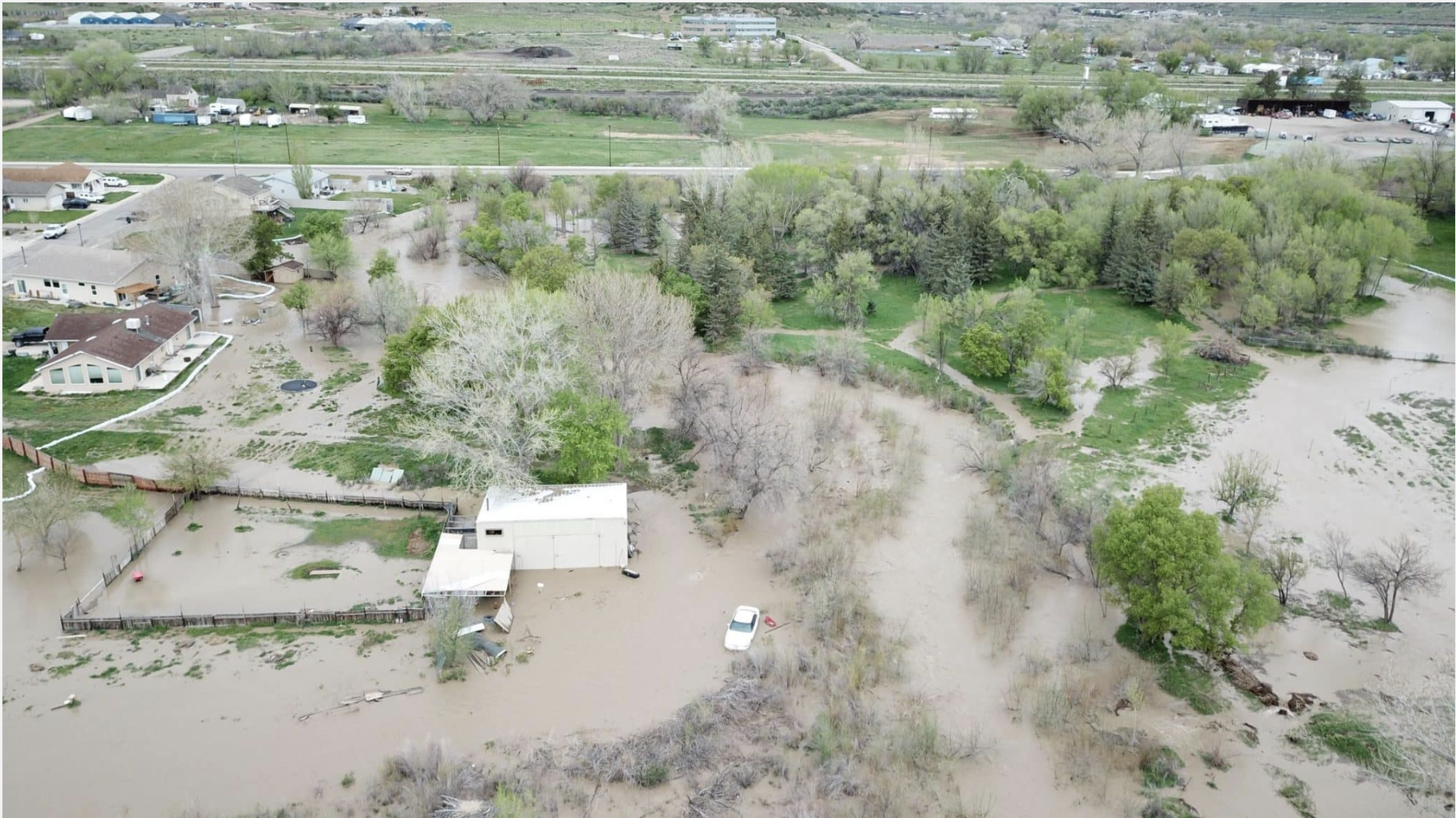
Town Manager Travis Elliott said Thursday [May 4, 2023] morning that the flow of Parachute Creek is currently at its highest it has been in nearly 50 years. The creek runs from the high country north of town into the Colorado River.
During a high runoff season in 1976, the creek reached a depth of 9.47 feet. As of 11 a.m. Thursday, a monitor showed the creek had reached a depth of 9.42 feet deep. The creek also reached a flow of 1,120 cubic feet per second, as of 3 p.m. Thursday.
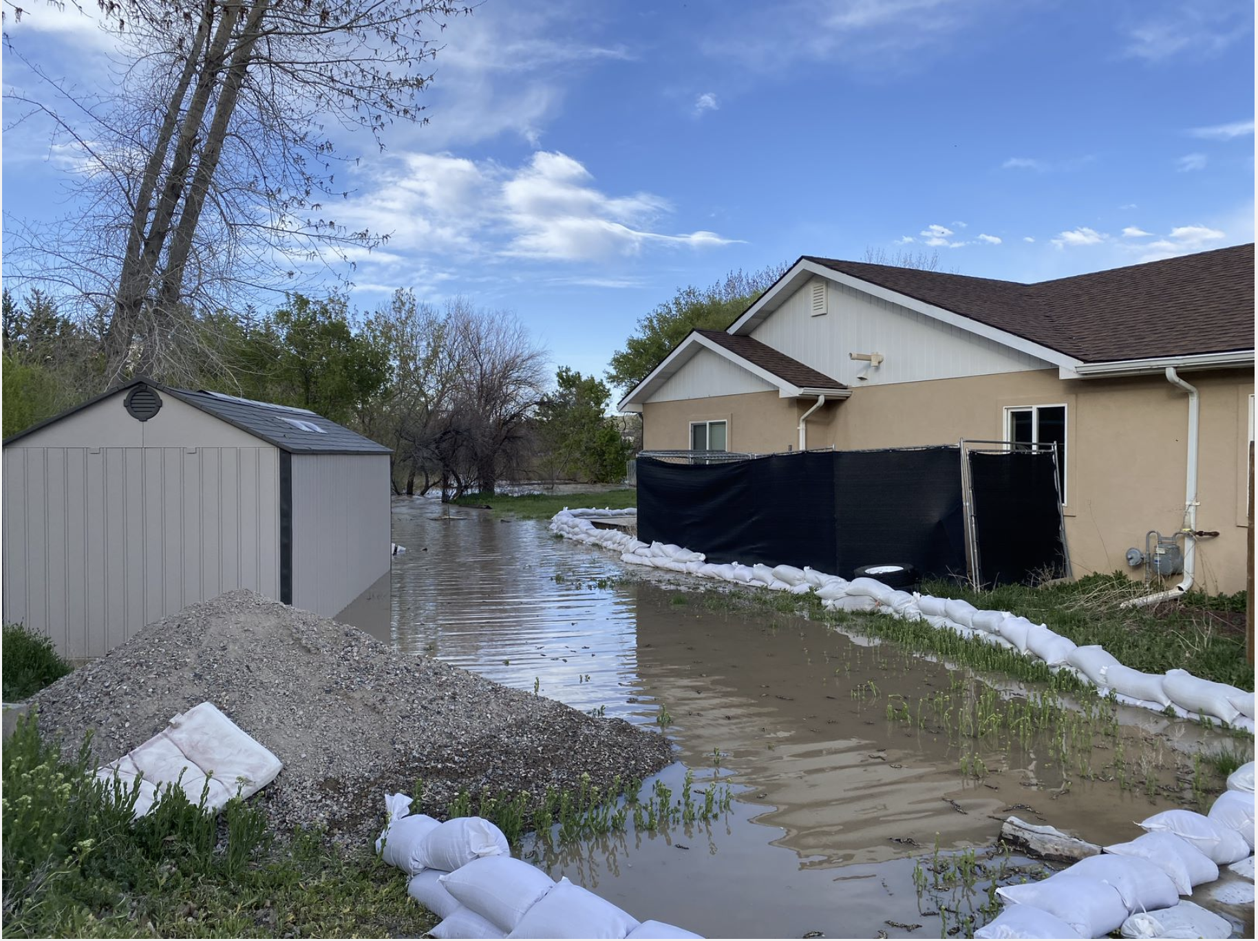
The rising water level has caused flooding in multiple spots throughout town, which is threatening up to 16 buildings and residences. This includes neighborhoods along Cardinal Way, near Grand Valley High School, Cottonwood Park and Russey Avenue on the north side of Interstate 70.
“In some places it looks like the swamplands of Louisiana,” Elliott said. “But, overall, I think we are in good shape thanks to the generosity and resiliency of our community members.”
There have so far been no indications of evacuations. Community members have spent this past week setting up sandbags and barriers in the hopes of keeping the rising water levels at bay.
“We’ve gone through about 1,000 sandbags,” Elliott said.
Structures being directly threatened by water include sheds, shops and various outbuildings, as well as homes. One residential basement is already flooded in three feet of water, Elliott said.
The city is also concerned the rising waters could reach the bottom of local bridges while the city is monitoring its sewer lift station at the wastewater treatment plant.
One Cardinal Way resident, Brandon Renck, said his backyard is currently being threatened by water.
“That’s definitely swirling around our house,” he said. “Some of the neighbors down the street have it worse than us. It’s definitely scary.”
Renck said his backyard is adjacent to Parachute Creek and the water damaged his landscaping. He also said he had a “really nice fence that got swept away.”
“We have a row of sandbags on our property,” he said. “If it gets high onto our grass, it would get to our back door.
We have friends we can stay with. Other than that, there’s not a whole lot that we can do.”
Mayor Tom Rugaard said, instead of going to practice, he brought members of his wrestling team to help put up sandbags. The Grand Valley Fire Protection District, Grace Bible Church, other high school kids and various residents have helped with mitigation efforts. The Garfield County Sheriff’s Office, its emergency manager, and the city of Rifle have made it clear they’re on standby, ready to help when necessary, the town said.
On Tuesday, the town had at least 40 volunteers helping fill sandbags, some as young as six as well as senior citizens.
“It’s been really cool, and I’m really proud of the people in our area who have come out of the woodwork to help the people in need,” Rugaard said.
“It’s really nice to be a part of a community that jumps in and helps others out.”
While the help has been nice, Rugaard did express some frustrations over the lack of data keeping for creeks and other elements.
“We have all these agencies that watch the Colorado River for us, but as far as tributaries? There’s not a lot of information out there,” he said. “There’s tools out there, but it would be nice to know how much snowpack is left and how that’s going to affect us yet.”
Elliott said there’s cooler weather in the forecast, which can hopefully help bring down the rising levels of Parachute Creek.
“We know there’s a lot more coming,” he said. “It’s all a matter of how fast it melts.”
Here’s a drone video of the flooding:
Garfield County is providing sandbags to residents in unincorporated areas who may be at risk of flooding as the local snowpack melts and rivers and streams rise. Up to 20 filled sandbags may be available on site at Garfield County Road and Bridge locations or residents can pick up 50 empty sandbags that they can fill off site.
The bags area available from 8 a.m. to 4 p.m. at the Rifle Road and Bridge campus, 0298 County Road 333A, and by appointment only from 7 a.m. to 3 p.m. at the Glenwood Springs facility, 7300 Highway 82. Residents of unincorporated western Garfield County can also pick up unfilled sandbags at the De Beque Fire Protection District station, 4580 U.S. Highway 6. Those bags can be filled at the Cowboy Chapel at the corner of county roads 204 and 211, just north of De Beque.
Residents living within cities or towns should contact those municipalities directly for assistance with issues related to potential flooding. Contact Garfield County Road and Bridge at (970) 625-8601 for more information or to schedule an appointment to pick up sandbags at the Glenwood Springs location.
Visit garfield-county.com for local updates on flood conditions and possible impacts and sign up for Garfield County Emergency Communications Authority (GarCo911) alerts at garco911.com/.
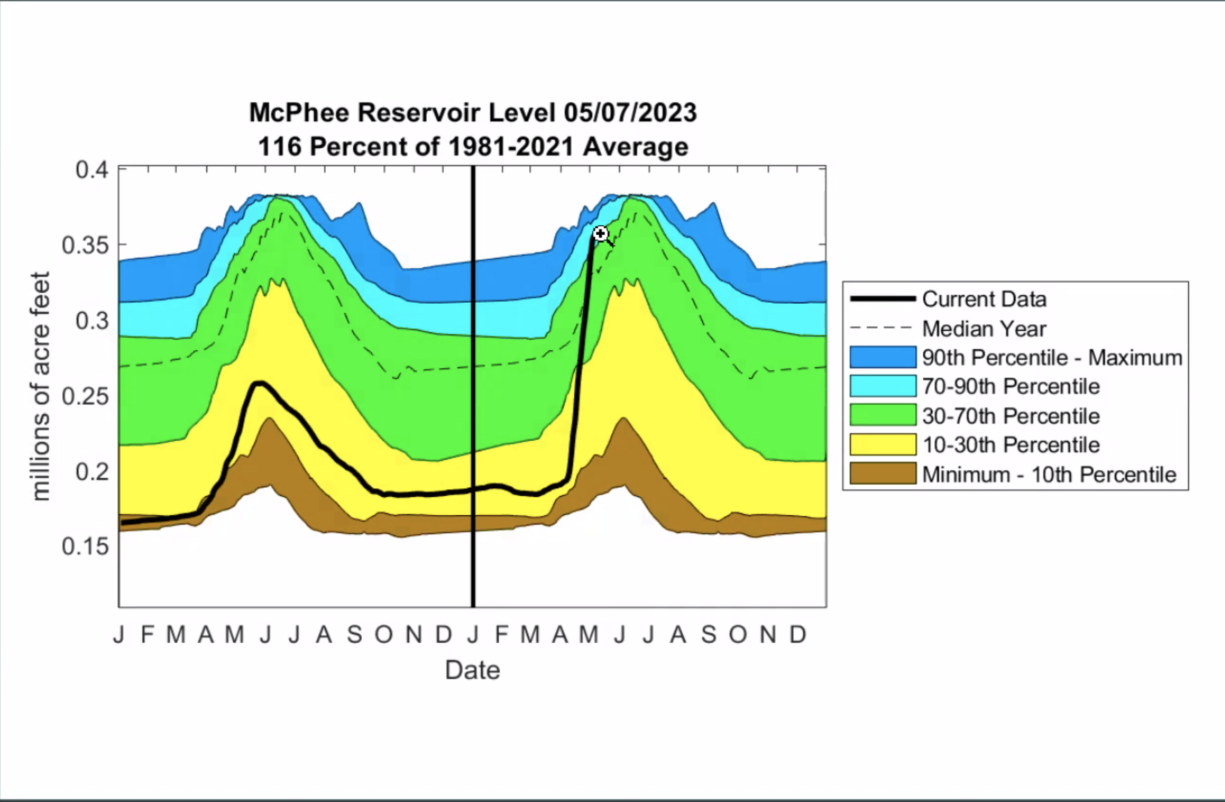
A gorgeous #Colorado canyon will be raftable for the first time since 2019 thanks to heavy snowpack: But the #DoloresRiver is just one of many rivers where the rafting outlook is great this season — The #Denver Post #runoff

Click the link to read the article on The Denver Poste website (John Meyer). Here’s an excerpt:
The Dolores River in southwestern Colorado can be one of the best rafting destinations in the country when it has enough water. It offers gorgeous scenery in the high desert of the Colorado Plateau and history dating back to the ancient Anasazi, who used it as a highway to and from Mesa Verde not far to the south. There are many years when the Dolores is not runnable for commercial rafting outfitters because of insufficient water, though. When they can operate there, as they will this year thanks to Colorado’s abundant mountain snowfall this past winter, rafters and outfitters rejoice. The last time the Dolores could support rafting was in 2019…

When snowpack is meager, runoff from the upper Dolores is stored in McPhee Reservoir near the town of Dolores for agricultural needs. This year, thanks to the great snowpack at its headwaters in the shadow of the 14,246-foot Mount Wilson near Telluride, there will be some left over for recreation, which happens down river from the reservoir…
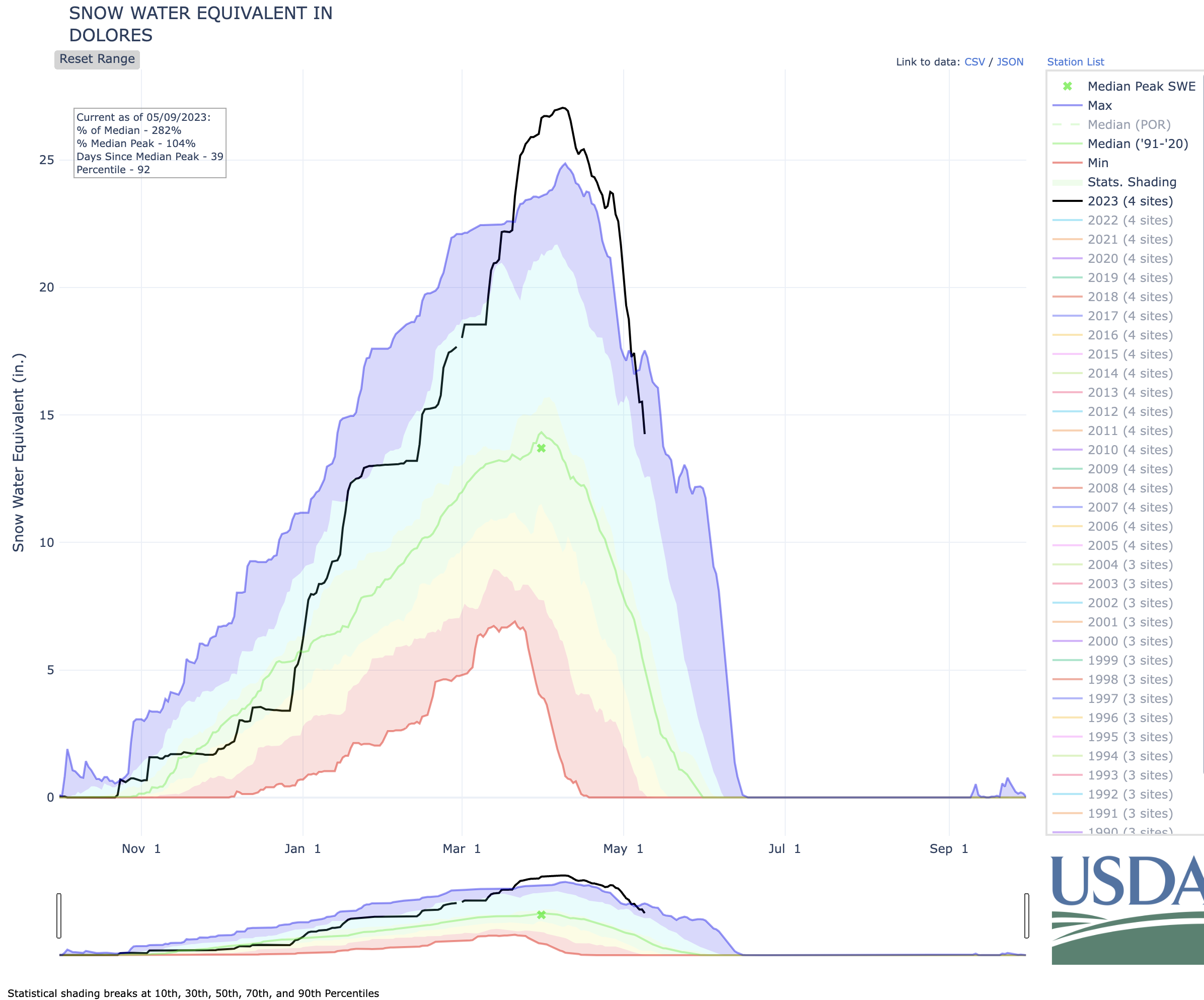
With rafting season beginning this week for many outfitters in the state, the snowpack in nearly every Colorado river basin is near normal or above, some way above normal. The San Miguel, Dolores, Animas and San Juan basin this week stood at 88% above normal, and the adjacent Gunnison River basin was 71% above normal. Drainage in the northwest part of the state — which includes the Yampa, White and Green rivers — is 41% above normal, and the Colorado River headwaters is 24% above normal. Colorado rafting companies are expecting good things. The Arkansas basin’s overall snowpack stands at only 78% of normal, but its flows can be augmented by diversions from places in the high country where snowpack is better. Those water management decisions are made primarily for other purposes, such as agriculture, but rafters get to recreate on that water first. The Arkansas is Colorado’s most popular river for rafting by far…The Blue River, north of Silverthorne, may be runnable this year.
USDA, #Colorado Introduce Additional #Conservation Practice to Address Regional #Drought Concerns

Click the link to read the release on the USDA website:
The U.S. Department of Agriculture (USDA) and the State of Colorado are continuing and strengthening their Conservation Reserve Enhancement Program (CREP) partnership to support and empower Colorado’s agricultural producers and landowners in reducing consumptive water use and protecting water quality, while conserving critical natural resources. Specifically, the newly revised Colorado Republican River CREP project, now available through USDA’s Farm Service Agency (FSA) and the Colorado Department of Natural Resources, will offer producers a dryland crop production practice on eligible cropland. This option will give producers meaningful tools to continue farming as they work toward permanently retiring water rights and conserving the Ogallala Aquifer for future generations.
“This project is an example of how targeted and thoughtful federal-state partnerships can help address local natural resource concerns,” said FSA Administrator Zach Ducheneaux. “The Colorado Republican River Conservation Reserve Enhancement Program (CREP) will help us meet an intertwined and complex set of challenges head-on, providing opportunities for producers to keep working lands working while reducing their water use and adapting climate-resilient agricultural practices. With the new dryland crop production practice provided through this agreement, producers with eligible land will have both the authority and access to the necessary technical assistance to successfully transition away from irrigated production while maintaining soil health and wildlife habitat. I am deeply grateful for the State of Colorado’s commitment to not just reaching an agreement but reaching the right agreement and strengthening a long-term partnership that will support Colorado producers into the future.”
Through the revised Colorado Republican River CREP, USDA and the State of Colorado will make resources available to program participants who voluntarily enroll in CRP for 14-year to 15-year contracts. This CREP provides participants with two ways to enroll eligible land. Producers can enroll eligible land in “CP100, Annual Crop Production, Non-Irrigated.” This practice transitions irrigated cropland to non-irrigated crop production and establishes complimentary wildlife habitat in and along the cropland. Additionally, participants within the Republican River CREP project area may enroll eligible land in “CP2, Permanent Native Grasses,” “CP4D, Permanent Wildlife Habitat,” and “CP23 or CP23A, Wetland Restoration.” These conservation practices remove cropland from agricultural production and convert the land to an approved conservation cover.
Through both enrollment options, producers will earn an annual rental payment and cost share on eligible components of the practice.

The dryland crop production practice is unique because producers will be able to keep these lands working while they implement conservation-minded agricultural practices including no till farming, cover crop installation and wildlife-friendly harvesting. USDA’s Natural Resources Conservation Service (NRCS) will work with eligible producers to develop conservation plans which include an approved annual crop rotation, minimum crop residue requirements, and management practices that support erosion mitigation and wildlife habitat. Unlike continuous and general CRP enrollment, participants with land enrolled in the CP100 may earn additional income from crops harvested from this acreage.
“By leveraging this CREP program, we can combine significant long-term reduction of consumptive water use and conservation-based dryland crop production when drought and water conservation resource concerns exist, as they so currently do,” said Kent Peppler, FSA’s Colorado State Executive Director. “This approach showcases that when we work to promote both production and conservation hand-in-hand, we have the capacity to create unique partnerships that benefit our economies, landscapes, and communities.”
Dan Gibbs, Executive Director, Colorado Department of Natural Resources, highlighted the positive impact this agreement will have on conservation efforts in the basin. Gibbs said, “We are excited about the outcome of this collaborative effort with the U.S. Department of Agriculture’s Farm Service Agency. This agreement will help Colorado continue to advance its conservation efforts that are leading the basin toward a sustainable future in agriculture. The dryland production alternative provides more options that attract greater participation in the reduction of irrigation while helping preserve the economy and culture of the local region.”
“Through partnership with DNR and USDA, Colorado farmers and ranchers will have the opportunity to continue production while focusing on conservation efforts,” said Kate Greenberg, Colorado’s Commissioner of Agriculture. “This agreement dovetails with CDA’s STAR Soil Health program, which helps bring financial and technical assistance to producers interested in expanding or introducing new climate smart practices into their operations,” said Colorado Commissioner of Agriculture Kate Greenberg. “Farmers and ranchers are experiencing first-hand the impacts of drought and climate change. Tools such as dryland CREP that focus on farmer-led solutions to healthy soils and water conservation are key to mitigating these effects in agricultural landscapes and providing producers options.”
Interested farmers, ranchers, and agricultural landowners are encouraged to contact FSA at their local USDA Service Center to learn more or to participate. Find contact information at farmers.gov/service-locator.
More Information
Currently, CREP has 35 projects in 27 states. In total, more than 784,800 acres are enrolled in CREP. The Colorado Republican River CREP is part of USDA’s broader effort to leverage CREP as an important tool to address climate change and other natural resources challenges while expanding opportunities for producers and communities, especially those historically underserved by USDA. In December 2021, USDA announced improvements to the program as well as additional staff to support the program.
USDA touches the lives of all Americans each day in so many positive ways. Under the Biden-Harris administration, USDA is transforming America’s food system with a greater focus on more resilient local and regional food production, fairer markets for all producers, ensuring access to safe, healthy and nutritious food in all communities, building new markets and streams of income for farmers and producers using climate smart food and forestry practices, making historic investments in infrastructure and clean energy capabilities in rural America, and committing to equity across the Department by removing systemic barriers and building a workforce more representative of America. To learn more, visit usda.gov.
A plan to pay farmers to use less of the #ColoradoRiver comes up dry — The #Denver Post #COriver #aridification
Click the link to read the article on The Denver Post website (Conrad Swanson). Here’s an excerpt:
One way to save massive amounts of water from the drying Colorado River — state and federal officials had hoped — was to effectively buy water this year from farmers and ranchers with a $125 million conservation program. But very few are taking the offer. Or those willing to sell were turned away.
“It’s a comical mess,” Shaun Chapoose, chairman of northeast Utah’s Ute Indian Tribe, said. “They ain’t fixing nothing.”
Colorado, New Mexico, Utah and Wyoming, which make up the river’s upper basin, launched the System Conservation Pilot Program late last year, offering money to farmers and others willing to forgo their water use this year, restarting a water-saving initiative that ran just a few years ago. This time around, though, the program is slated to spend twice as much to save a fifth less water, Colorado River officials say. Between the four states, 88 applications came in offering to save some water, Chuck Cullom, executive director of the Upper Colorado River Commission, said. The commission approved more than 80% of them…
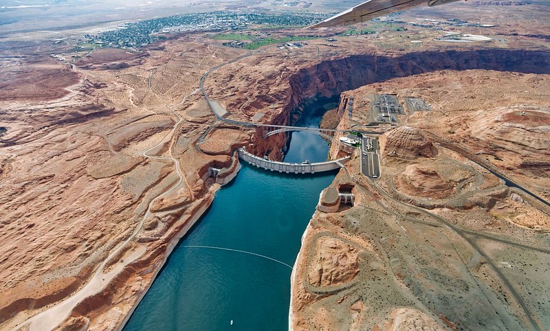
If each of the program’s approved applications works out as expected the upper-basin can expect to save about 39,000 acre-feet at a cost of about $16 million, Cullom said. That’s less than 2% of the smallest amount of water federal officials hope to save. Cullom said the program came together quickly because of dire conditions on the river. That timing made it difficult for farmers to participate. And he said potential participants weren’t clear on how best to apply or what kind of money they could expect in return for their water…
The concept is fairly simple. A farmer, rancher or even a city holds the rights to a certain amount of water that they’re allowed to draw from the Colorado River (or its tributaries) in a given year. The System Conservation Pilot Program had $125 million to dole out, offering them to use less. A farmer growing corn will use a certain amount of water in a typical year. But if they’re willing to grow barley instead, which might use two-thirds as much water, the state could pay them for the difference they’ve saved. Or they could offer not to grow anything, saving more water and theoretically earning even more money from the program. Expand that offer throughout each of the four upper-basin states and the hope is that enough people sign up to conserve a substantial amount of water. The more water left in the Colorado River, the higher the levels stay at lakes Powell and Mead, the more water that’s available to generate hydroelectricity, irrigate crops in Arizona and California and flow into major cities like Los Angeles, Las Vegas and Phoenix.
