Why making #ElNiño forecasts in the spring is especially anxiety-inducing — NOAA #ENSO

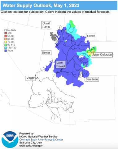
Click the link to read the article on the NOAA website (Michelle L’Heureux):

Given the relatively high probabilities for El Niño in our team’s April 2023 ENSO update, I decided to team up with some of my scientific colleagues, Antonietta Capotondi (NOAA Physical Sciences Laboratory and University of Colorado, Cooperative Institute for Research in Environmental Sciences) and Aaron Levine (@afzlevine, University of Washington, Cooperative Institute for Climate, Ocean, and Ecosystem Studies), to explain why making ENSO forecasts during the Northern Hemisphere springtime generally makes us want to skip the forecast. But we, of course, cannot because if a decent-sized El Niño is going to form, it is probably going to form in the spring or summer. Which means as much as we’d like to punt on ENSO forecasts in the spring, we have to issue Watches when the tropical Pacific starts pushing in that direction (as we recently did, footnote #1).

This is not the first blog rant post on the lower predictability of springtime ENSO forecasts (hereherehere). And it will probably not be our last! Researchers in the ENSO community are well aware of the forecasting challenges during the spring and are hard at work trying to better understand precursor patterns and fix model biases that may make it easier to predict ENSO in the future.

So, what’s the big deal in the spring? Especially when it comes to predictions of El Niño? It comes down to uncertainty in two of the main ingredients that give rise to El Niño.

  1. In the spring, it is difficult to know whether surface west-to-east (“westerly”) wind anomalies across the tropical Pacific Ocean will continue through the summer and persist long enough to reinforce the developing El Niño.
  2. The heat in the subsurface tropical Pacific Ocean is a necessary precursor for El Niño but it is not always sufficient.

Let’s focus on #1 first: the persistence of the surface winds. Dr. Capotondi has published research exploring the relationship of surface winds across the tropical Pacific with ENSO. She used a very detailed satellite-based wind dataset for her analysis and found that the interannual changes in the surface winds are the key ingredient for triggering El Niño (footnote #2). Without persistence of these tropical winds, many El Niño events struggle to achieve lift off and can fizzle. It is this interannual wind variability that determines whether you get a major El Niño (e.g. 1997-98) or an El Niño “bust” (e.g. 2014).

Let’s examine the figures below to visualize this. Starting in March 1997, westerly wind anomalies (warm colors) began to form over the western tropical Pacific Ocean (left panel). In the 1997 case, the interannual variability in the winds (middle panel) was especially strong and long lasting, extending over a year and shifting very gradually eastward with time. A major El Niño event formed and peaked during the 1997-98 winter.

During 1997, the evolution of the surface zonal wind anomalies (in meters per second) along the equatorial Pacific Ocean. Red shading indicates anomalous westerly (from the west) winds, while blue shading denotes anomalous easterly winds. The left panel emphasizes winds that are relatively short-term (the filter isolates periods more than 5 days). The right panel emphasizes the “interannual” winds that are longer-term and more persistent (the filter isolates periods greater than 250 days). On average, the surface winds across the tropical Pacific are easterly, so westerly anomalies—departures from average conditions—can weaken the Walker Circulation. But only if they persist do they lead to El Niño. See Capotondi et al. (2018) for more details on the calculation and data. Figure provided by Antonietta Capotondi and modified by Climate.gov.

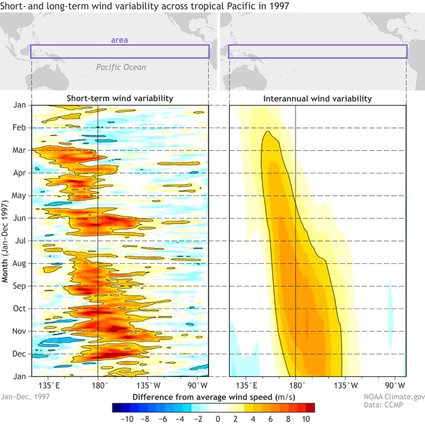
Now let’s look at the same period of months during 2014, which, in the spring, was predicted to be a potentially major El Niño event. Right on cue, similar to 1997, the westerly wind anomalies began early in the calendar year and lasted through April (left panel below). However, for some unknown reason, the westerly winds began dissipating and the interannual wind variability was very weak-to-nonexistent for the rest of 2014 (middle panel below).

During 2014, the evolution of the surface zonal wind anomalies (in meters per second) along the equatorial Pacific Ocean. Red shading indicates anomalous westerly (from the west) winds, while blue shading denotes anomalous easterly winds. The left panel emphasizes winds that are relatively short-term (the filter isolates periods more than 5 days). The right panel emphasizes the “interannual” winds that are longer-term and more persistent (the filter isolates periods greater than 250 days). On average, the surface winds across the tropical Pacific are easterly, so westerly anomalies—departures from average conditions—can weaken the Walker Circulation. But only if they persist do they lead to El Niño. See Capotondi et al. (2018) for more details on the calculation and data. Figure provided by Antonietta Capotondi and modified by Climate.gov.

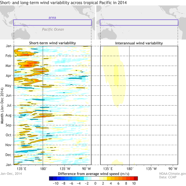
Bottom line: if the surface westerly wind anomalies fizzle out and do not continue to recur and intensify throughout the year (the interannual variability), then El Niño can similarly fail to get going. Unfortunately, we can only see this interannual wind variability after the year is over (and we are looking back at the previous year). In the midst of the spring/summer, we do not know whether these winds are random-random or are going-somewhere-random (they are considered mostly forecastable out to 7-10 days). Not ideal, we know. 

This brings us to #2: The presence of above-average oceanic heat in the tropical Pacific Ocean. Dr. Levine recently started a 3-year NOAA Climate Program Office (CPO) funded research project on the topic of El Niño false alarms, which are El Niño events that were confidently predicted to happen, but then failed to do so for some mysterious reason. Dr. Levine provided the figure below which displays the many different climate forecasting models that are part of the North American Multi-Model Ensemble (NMME).


Model forecasts (light gray lines: means from the North American Multi-model Ensemble) and observations (black lines: ERSSTv5 temperature data) of ENSO as measured by the Niño-3.4 index. Years are selected based on the nine largest April values of subsurface warm water volume anomalies (0-500 meters below the surface) of the tropical Pacific Ocean (120E-80W). Subsurface data based on TAO buoys. Figure provided Aaron Levine and modified by Climate.gov.

Each panel in the figure shows 9 different ENSO forecasts made during the month of April. These forecasts all have one major thing in common, which is the presence of above-average temperatures within the subsurface (0-500 meters below the surface) of the tropical Pacific Ocean (footnote #3). The majority, or 6 of the 9 April forecasts, had elevated chances of El Niño events developing later in the year. Another way to express this is that enhanced oceanic heat in the spring can make it more likely an El Niño could form, but it’s not a guarantee either.

Now let’s look closer at those 6 April forecasts that were predicted to become El Niño events (1982, 1990, 1997, 2014, 2015, 2018). Out of that group, 4 of the 6 became El Niño events and 2 failed to form (1990, 2014). Interestingly, of the ones that became El Niño events, the ultimate strength was mostly underestimated, meaning that the El Niños ended up becoming stronger in the winter than the majority of model ensembles predicted in April. So, while bust potential is a risk, there is also limited evidence that models can still be somewhat conservative with forecasting peak intensity! 

On the net, while the tropical Pacific precursors of El Niño are currently evident this spring, there is a certain amount of forecast uncertainty that will not go away. Come this summer/fall, we will see whether the conditions we’re seeing this spring were, in fact, sufficient to become a bona fide El Niño (and potentially a significant one). Watch this space.

Footnotes

(1) So, if spring forecasting is such a challenge, then why do the current probabilities seem so high? As Emily laid out in her recent blog post and in the official ENSO discussion, we are currently seeing some of the required precursors of El Niño: (a) recurrence of westery wind anomalies across the equatorial Pacific and (b) emergence of above-average ocean heat content. Morever, many of the state-of-the-art climate models we consider (such as those in the NMME) are providing peak chances of El Niño in excess of 90%. However, because we know the objective model guidance tends to be overconfident this time a year (here and here), the chances in the official outlook are slightly lower (peaking in the mid-80%).

(2) What are these interannual winds? Interannual in our lingo are the “year-to-year” changes. Retrospectively, we can examine the part of the winds that were the most persistent, lasting over a span of at least 8 months (greater than 250 days in this study).

(3) Aaron is examining the 9 cases with the largest April tropical Pacific subsurface ocean heat content anomalies since 1980 via the NOAA PMEL website showing measurements from the TAO buoys.

The #RioGrande is FLOWING in #Albuquerque! — @GGutierrez_48 #runoff

The latest briefing is hot off the presses from Western Water Assessment

Click the link to read the briefing on the Western Water Assessment website:

May 8, 2023 – CO, UT, WY

As of May 1, snow-water equivalent (SWE) values remain above to much-above normal for the majority of the region, especially in Utah. April precipitation and temperatures were below to much-below normal for the region. Streamflow volume forecasts are above to much-above average for the Upper Colorado River and Great Basins, and the inflow forecast for Lake Powell is 172% of average, continuing to provide much-needed water after record-low water levels. Regional drought conditions significantly improved during April and now drought covers only 32% of the region, driven by wetter conditions in Utah. Neutral ENSO conditions are expected to persist throughout the spring, and there is an increased probability of above average temperatures for parts of Utah and Wyoming during May, and parts of Utah and Colorado from May-July.

April precipitation was below normal for much of the region. Less than 50% of normal April precipitation occurred in northern Wyoming, particularly in Big Horn County, eastern Utah, particularly in Carbon and Emery Counties, and northeastern Colorado. Record-dry conditions occurred in east-central Utah, mostly in Carbon County. Areas of above normal precipitation occurred in southwestern to central Wyoming from the Upper Green River to western North Platte Basins, and southeastern Colorado along the Arkansas River Basin. An area of much-above normal precipitation occurred in Lincoln and Uinta Counties in southwestern Wyoming.

Regional temperatures during April were below normal. Large portions of Colorado, Utah, and Wyoming experienced much-below normal temperatures, particularly in Wyoming where temperatures were 6 to 10 degrees below normal. Record-cold temperatures for April occurred in the Upper Green River region of southwestern Wyoming and northernmost Utah, mostly in Rich County.

Regional snowpack is near to much-above normal for the entire region except for the Arkansas River Basin where May 1 SWE is slightly below normal at 81%. Much-above normal SWE exists for much of the region, including northeastern Wyoming, southwestern Colorado, and all of Utah, with a staggering 1,256% of normal SWE for the Six Creeks Basin on the Wasatch Front and 953% of normal SWE for the Southeastern Utah Basin. Extremely high percent normal SWE is driven by continued deep snowpack at low elevation sites. For example, the Louis Meadows SNOTEL site (6,700 feet) in the Six Creeks Basin is at 9,933% of normal because May 1 median SWE is 0.3” and current SWE is 29.8”. Statewide percent median SWE was 139% for Colorado, 249% for Utah, and 140% for Wyoming. As of May 1, snowpack is generally near normal east of the Continental Divide in Colorado and in northern Wyoming, and above normal on the West Slope of Colorado and in southern Wyoming.

Seasonal streamflow volume forecasts are above average to much-above average for most regional river basins. Streamflow forecasts are highest for the Great Basin where forecasted volumes are 132-451% of average. Below normal (60-90%) seasonal streamflow volumes are forecasted for the South Platte and Arkansas Basins, and near-normal (90-110%) volumes are forecasted for the Big Horn, Powder, Snake, Upper Colorado (mainstem), and Yellowstone River Basins. Above normal seasonal streamflow (110-130%) is forecasted for the Rio Grande and Upper Green River Basins, and much-above normal streamflow (>130%) is forecasted for the remaining regional river basins, with streamflow forecasts reaching above 300% for sites in the Provo/Utah Lake, Sevier, Six Creeks, Virgin, and Weber River Basins. Seasonal streamflow forecasts for most large Upper Colorado River Basin reservoirs are much-above normal, leaving only Fontenelle with an above normal forecast of 113% and Green Mountain with a below normal forecast of 84%. The inflow forecast for Lake Powell is 172% of normal.

Regional drought conditions were mixed, with improvement throughout most of Utah and degradation throughout the Front Range and south-central portion of Colorado. At the end of April, drought covered 32% of the Intermountain West, down from 45% at the end of March. Drought conditions significantly improved in Utah; drought covered 65% of the state at the end of March, decreasing to 19% at the end of April. Drought conditions slightly improved in Wyoming, from 37% to 30% coverage by the end of April. Drought conditions worsened in Colorado, increasing in coverage from 36% to 44% by the end of April. Pockets of extreme (D3) drought remain in southeastern Wyoming and Colorado and developed in south-central Colorado. Exceptional (D4) drought continues in southeastern Colorado’s Baca County.


West Drought Monitor map May 2, 2023.

Neutral ENSO conditions continued in April and are expected throughout the spring. In some regions of the Pacific Ocean, sea surface temperatures warmed to above average, indicating a shift towards El Niño in the coming months. There is a 62% chance of El Niño developing during May-July, and a greater than 80% chance of El Niño by the fall. There is an increased probability of above normal temperatures during May in western Wyoming and northern Utah. The May-July NOAA seasonal forecasts predict an increased probability of above normal temperatures in southeastern Utah and southern Colorado.

Significant April weather event. Little Cottonwood Canyon (LCC) experienced a historic avalanche cycle in early April caused by historically deep snowpack (903” of snowfall at Alta), intense snowfall, and rapid warming. From 4/3 – 4/5, upper LCC received 63” of snow with 4.5” of SWE. Temperatures were very cold during the storm, including a record minimum temperature at the Alta Guard site of 1F on 4/6. By 4/10, the maximum temperature warmed to 56F, a daily record. A daily record temperature of 56F was also set on 4/11 and concluded a full three days without below freezing temperatures, which increases the risk for wet slab avalanches. 

High snowfall and warm temperatures caused very dangerous avalanche conditions, resulting in the closure of LCC Road from 4/2 – 4/13 with a brief opening on the morning of 4/7 to allow people to leave the canyon. The length of this canyon closure is unprecedented. Two distinct avalanche cycles occurred during the 12-day canyon closure. The first avalanche cycle occurred during and immediately after the storm. The second avalanche cycle was a wet avalanche cycle that began around 4/9 and was caused by rapidly warming temperatures and the lack of below freezing conditions at night. Many dozens of avalanches occurred naturally or as a result of avalanche mitigation efforts in avalanche paths that impact the road or infrastructure in LCC. Avalanches buried the road in 15-20 locations up to 30 feet deep and several hundred yards wide. Some paths hit the road multiple times. Many avalanche paths that ran have a historical avalanche frequency of more than 50 years and these paths enlarged their run-out zones, mowing down mature aspen, fir, and oak trees. One path, Coalpit #4, ran so large that the avalanche crossed Little Cottonwood Creek and traveled upslope to hit the road. Another slide occurred on 4/6 where a slide path across the road from Snowbird slid naturally and buried the edge of the beginner ski slope while the ski area was open. Snowbird immediately closed the resort and performed a probe line search of the area to ensure no one was buried. Fortunately, no one was injured in the incident.

Navajo Dam Spring operations update — Reclamation #SanJuanRiver #ColoradoRiver #COriver #aridification

The outflow at the bottom of Navajo Dam in New Mexico. Photo: Brent Gardner-Smith/Aspen Journalism

From email from Reclamation (Susan Novak Behery):

BUREAU OF RECLAMATION 

NAVAJO UNIT FORECAST FOR  

SPRING OPERATIONS 

May 9, 2023 

High snowpack in the San Juan River Basin this year has led to an above-average inflow forecast into the Navajo Reservoir.  The latest most probable inflow forecast from the Colorado Basin River Forecast Center has increased to 160% of average inflows due to snowmelt runoff from April through July.  

The forecast now allows for a spring peak release as recommended by the San Juan River Basin Recovery Implementation Program (SJRIP).  The release will ramp up slowly, peaking at 5,000 cfs for 21 days before ramping back down. The currently planned schedule is below.  As this operation is entirely dependent on weather, inflows, and on-the-ground conditions, please stay tuned for updates and changes.  

The current schedule for planned changes is below. A notice will be sent out prior to each release change. 

Date  Day End of Day Release (cfs) Notes 
5/9/2023 Tue 500  
5/13/2023 Sat 800  
5/15/2023 Mon 1200  
5/18/2023 Thu 2000 Begin ramp up 
5/19/2023 Fri 3000  
5/22/2023 Mon 4000  
5/23/2023 Tue 4600  
5/24/2023 Wed 4800  
5/25/2023 Thu 5000 Hold at 5,000 cfs for 21 days 
6/14/2023 Wed 4800 Begin ramp down 
6/15/2023 Thu 4500  
6/16/2023 Fri 4000  
6/17/2023 Sat 3000  
6/18/2023 Sun 2800  
6/19/2023 Mon 2500  
6/20/2023 Tue 2000  
6/21/2023 Wed 1500  
6/22/2023 Thu 1200  
6/23/2023 Fri 1000  
6/24/2023 Sat 800  
6/25/2023 Sun 500  

This operation is subject to changes in river flows and weather conditions and will be coordinated daily with local, state, and federal agencies to ensure objectives are met in a safe manner. 

Areas in the immediate vicinity of the river channel may be unstable and dangerous. Please use extra caution near the river channel and protect or remove any valuable property in these areas. 

For more information, please see the following resources below: 

Bureau of Reclamation:  

San Juan County, New Mexico, Office of Emergency Management:   

Navajo Nation Department of Emergency Management:  

2023 #COleg: Stream restoration bill watered down — @AspenJournalism

Workers construct a post-assisted log structure or PALS, on the Brush Creek Valley Ranch and Open Space south of the town of Eagle. These structures mimic large woody debris like a downed cottonwood and are designed to promote and restore natural stream functioning in areas that have been degraded. Photo courtesy of Eagle County Open Space

Click the link to read the article on the Aspen Journalism website (Heather Sackett):

Colorado lawmakers may pass a stream-restoration bill this session, but it won’t be the one proponents and environmental groups were hoping for.

A bill aimed at making it easier for stream-restoration projects that mimic beaver activity to take place has been gutted after stakeholders couldn’t reach an agreement, underscoring how difficult it is for environmental interests to gain a toehold under Colorado’s system of water law.

An original draft of Senate Bill 270 clarified that restoration projects do not fall under the definitions of a diversion, storage or a dam; are presumed to not injure downstream water rights; and do not need to go through the lengthy and expensive water-court process to secure a water right or augmentation plan.

Project proponents would have had to file an information form with the Division of Water Resources (DWR) showing that projects would stay within the historical footprint of the floodplain before it was degraded and didn’t create new wetlands. Anyone, including downstream water users who believed the project would injure their water rights, could then challenge the project plans by filing a complaint.

“Beaver Dam Analogues” or “Temporary Wood Grade Structures,” or TWGS, (pronounced like twigs), are designed to help back up water and create a lively wetland habitat that encourages healthy biodiversity not just for the cutthroat, but the entire ecosystem. They are being employed in what’s called “Process-Based Restoration.” These man-made structures are relatively easy and straightforward to make. They are built with natural resources such as wooden posts, willow branches, aspen branches, and rocks. Though they are simple to create, Remshardt said “we’re not as good at building them” as the beavers. Photo courtesy Rio Grande Headwaters Restoration Project

The types of projects that the original bill aimed to address are known as low-tech, process-based restoration and include things such as beaver-dam analogs (BDAs). These temporary wood structures consist of posts driven into the streambed with willows and other soft materials woven across the channel between the posts.

By pooling water on small tributaries in the headwaters, these process-based restoration projects act as if rehydrating a dry sponge and restore watersheds to a more natural condition before they were degraded by human activities. These projects can improve water quality, raise the water table, and create a buffer against wildfires, drought and climate change. The idea is that by creating appealing habitat in areas that historically had beavers, the animals will recolonize and continue maintaining the health of the stream.

But the watered-down version of the bill that made it out of committee and is up for a second reading in the House on May 3 no longer addresses these types of projects. After amendments removed language referring to these projects, the bill now only includes minor stream-restoration activities such as bank stabilization or restructuring a channel to recover from wildfire or flood impacts.

“The stuff that got taken out was the projects that would reconnect the channel and the floodplains and push water out of the channel in a way that would saturate the meadow and potentially change the hydrology,” said Kelly Romero-Heaney, assistant director for water policy at the Colorado Department of Natural Resources (DNR). “Those projects are very much intended to maximize the ecological uplift from a stream restoration project. They are also the projects that gave the most heartburn to the water community.”

DNR staff and environmental groups were the proponents of the original legislation. If stream-restoration projects were required to secure a water right and spend money on an expensive augmentation plan, in which water is released to replace depletions that it causes, it could discourage these types of projects. Currently, proposals are evaluated by division engineers, who determine whether an augmentation plan is needed.

Two PALS on the Brush Creek Valley Ranch and Open Space south of the town of Eagle help restore natural stream functioning in areas that have been degraded by ranching and grazing. Eagle County Open Space installed 13 on a half-mile stretch of Brush Creek last fall. Photo courtesy of Eagle County Open Space

Agricultural concerns

Some agricultural water users were concerned that keeping water on the landscape for longer could potentially injure their downstream water rights by slowing the rate of runoff and creating more surface area for evaporation.

“Any time you’re talking about water and changing things in the water system, you run the risk of impacting water rights and the doctrine of prior appropriation, which is my guiding star when it comes to water issues,” state Sen. Cleave Simpson, a Republican, said at a Senate Agriculture and Natural Resources Committee hearing April 13. Simpson, a sponsor of the bill, is a rancher who represents District 6.

Prior appropriation is the cornerstone of Colorado water law in which the oldest water rights have first use of the river.

Austin Vincent, general counsel and director of public policy for the Colorado Farm Bureau, said the original bill would have placed an unfair and expensive burden on water rights holders to file a complaint and prove they were being injured by a stream-restoration project.

“It takes money to get an attorney and an engineer to prove your water right was injured,” he said. “The Farm Bureau is happy we are having this conversation, but we need to make sure this policy is done right. With the prior appropriation system being the law of the land here in Colorado, we need to make sure that’s not eroded.”

Pitkin County Commissioner Kelly McNicholas Kury testified at the committee hearing, expressing the county’s strong support for the original draft of the bill.

“Our western rivers are the lifeblood of our state and they are in crisis,” she said. “We should all be committed to restoring our rivers to a healthy and thriving state.”

Pitkin County has funded a summer program with the U.S. Forest Service for a beaver inventory in the headwaters of the Roaring Fork River, which could be the first step toward reintroducing the animals.

During negotiations on bill amendments, some groups had floated the idea of a cap that would place a limit on how much new surface area of water that restoration projects were allowed to create. But a too-small cap didn’t appeal to environmental groups.

“The cap became the dynamite stick in the water community dialogue,” said Abby Burk, western rivers region program manager for Audubon Rockies. “If we had gone forward with these caps, we would have caged stream restoration, so it was better to pause.”

Legislators have said they plan to revisit the issue in the interim committee and perhaps again next session with a new bill addressing process-based restoration projects.

This PALS on the Brush Creek Valley Ranch and Open Space south of the town of Eagle mimics a downed cottonwood. The Division 5 Engineer’s office said these post-assisted log structures don’t injure downstream water rights. Photo courtesy of Eagle County Open Space

Eagle County project

Staff from Eagle County Open Space learned firsthand the issues that can arise with stream-restoration projects, when they planned for 13 beaver-dam analogs to restore a half-mile section of Brush Creek that had seen intense ranching and grazing. The creek had been straightened and disconnected from its floodplain, and the riparian and aquatic habitat was impaired.

County staff submitted their plans to DWR, which told them they would have to get a plan for water replacement, or augmentation, to replace the water that would be evaporated from the small ponds created by the project.

“It appears the BDAs associated with this project will result in a series of impoundments in ponds/pools that will result in additional evaporation from increased surface area that will injure downstream water rights,” the response from DWR reads.

Getting an engineer to model the amount of water lost, then implementing a plan to replace that water was cost-prohibitive for the county, said Peter Suneson, open-space manager for Eagle County.

“Modeling a leaky beaver dam is doable, but you’re going to end up throwing a lot of money at it and you still have to find water to put back in the creek,” he said.

Instead of the BDAs, Eagle County instead moved forward with another low-tech, process-based project that DWR did not have a problem with: post-assisted log structures (PALS). These mimic large woody debris — a downed cottonwood tree, for example — that is affixed to a streambank and extends into the channel but does not span the entire waterway.

According to DWR, as long as PALS do not funnel water away from a diversion structure such as an irrigation headgate and do not impound water, they will not injure downstream users.

“We got 13 PALS in last fall and we are going to do that again this fall,” Suneson said.

It was exactly these types of projects that drafters of the original bill were hoping to make exempt from the water-court process, but which remain evaluated on a case-by-case basis by division engineers. But as drought and climate change have tightened their grip on Colorado, resulting in less water to go around, even restoration projects that everyone agrees are beneficial to the environment can be contentious.

“The entrenched interests like to see the status quo protected and preserved and those newer types of water uses, whether it be recreational or environmental, are at the end of the line,” said Drew Peternell, director of Trout Unlimited’s Colorado Water Program. “It’s a tough uphill battle to pass legislation that allows water to be used for those newer values.”

Aspen Journalism is a nonprofit, investigative news organization that covers water, environment and social justice.

A beaver dam on the Gunnison River. Photo: Brent Gardner-Smith/Aspen Journalism