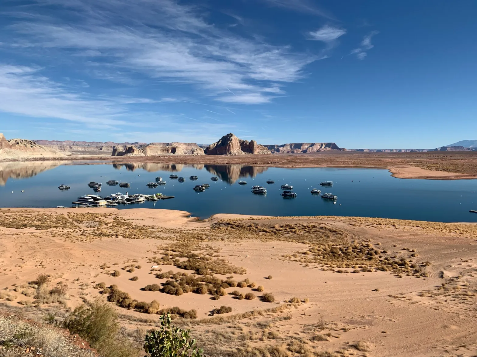
Houseboats on Lake Powell on Dec. 13, 2021, near Wahweap Marina, where the quarter-mile-long boat ramp is unusable due to low water levels. The Bureau of Reclamation Commissioner has said 2 to 4 million more acre-feet of conservation is needed to protect the system, leaving water managers wondering what authority the feds have over upper basin water projects. CREDIT: HEATHER SACKETT/ASPEN JOURNALISM
Click the link to read the article on the Colorado Public Radio website (Michael Elizabeth Sakas and Rachel Estabrook). Here’s an excerpt:
Colorado River “Beginnings”. Photo: Brent Gardner-Smith/Aspen Journalism
How long is the Colorado River and where does it start?
The river is 1,450 miles long and originates near Grand Lake, Colorado, in Rocky Mountain National Park…
Map credit: AGU
How many people depend on the Colorado River?
The Colorado River system supplies tens of millions of people across the West with water to drink, shower, and work, and it irrigates around 5 million acres of farmland…
Updated Colorado River 4-Panel plot thru Water Year 2022 showing reservoirs, flows, temperatures and precipitation. All trends are in the wrong direction. Since original 2017 plot, conditions have deteriorated significantly. Brad Udall via Twitter: https://twitter.com/bradudall/status/1593316262041436160
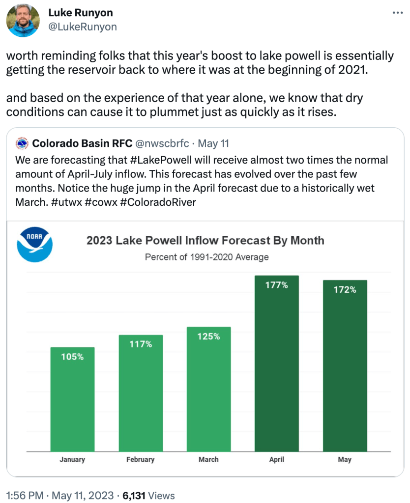
A wet and snowy weather pattern for much of the West brought at least a brief reprieve this winter. In the upper river basin, snowpack peaked at more than 150 percent of normal. While that was not as dramatic as what accumulated in California’s Sierra Nevada after a winter of repeated storms, snowfall set records in some parts of southwestern Colorado. The snow was slow to melt in early spring, with colder-than-normal temperatures and periods of mountain snow extending into late April. But early May warmth has triggered a surge of snowmelt. Temperatures rose into the 70s for several days early in the month in the mountains of western Colorado and eastern Utah…
After Lake Powell’s surface dropped to about 3,520 feet above sea level in mid-April, it has been largely rising. That accelerated to an increase of more than a foot per day over the past week, according to data from the federal Bureau of Reclamation, which owns and operates Glen Canyon Dam. The lake’s height reached about 3,533 feet above sea level on Tuesday. And the lake is forecast to rise 70 to 71 feet, in all, by the fall. That allowed the bureau in late April to release torrents of water from Lake Powell downstream as part of an experiment exploring potential rehabilitation of river wildlife and ecosystems along the Grand Canyon…
The water flows into Lake Powell are substantial, but in context, are not reason for celebration, Leeflang said. The forecasted 70-foot rise translates to the lake’s stores of water increasing from about 20 percent of its capacity to 30 percent, he said. [ed. Luke Runyon says that this
The May 1st forecast for the April – July unregulated inflow volume to Blue Mesa Reservoir is 830,000 acre-feet. This is 131% of the 30 year average. Snowpack in the Upper Gunnison Basin peaked at 138% of average. Blue Mesa Reservoir current content is 434,000 acre-feet which is 52% of full. Current elevation is 7470.4 ft. Maximum content at Blue Mesa Reservoir is 828,00 acre-feet at an elevation of 7519.4 ft.
Based on the May forecasts, the Black Canyon Water Right and Aspinall Unit ROD peak flow targets are listed below:
Black Canyon Water Right
The peak flow target is equal to 6,400 cfs for a duration of 24 hours.
The shoulder flow target is 810 cfs, for the period between May 1 and July 25.
Aspinall Unit Operations ROD
The year type is currently classified as Average Wet.
The peak flow target is currently 14,300 cfs and the duration target at this flow is currently 2 days.
The half bankfull target is currently 8,070 cfs and the duration target at this flow is currently 20 days.
Pursuant to the Aspinall Unit Operations ROD, releases from the Aspinall Unit will be made in an attempt to match the peak flow of the North Fork of the Gunnison River to maximize the potential of meeting the desired peak at the Whitewater gage, while simultaneously meeting the Black Canyon Water Right peak flow amount. The latest forecast for flows on the North Fork of the Gunnison River shows a high peak flow occurring near the middle of next week. Flows in the tributaries downstream of the North Fork confluence are also very high, which will help with meeting the flow targets on the lower Gunnison River at the Whitewater gage.
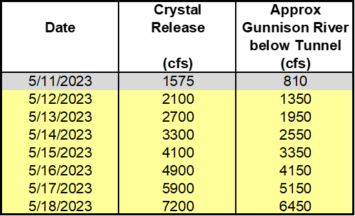
Therefore ramp up for the spring peak operation will begin on Friday, May 12th, with the intent of timing releases with this potential higher flow period on the North Fork of the Gunnison River. Releases from Crystal Dam will be ramped up according to the guidelines specified in the EIS, with 2 release changes per day, until Crystal begins to spill. The release schedule for Crystal Dam is:
The current projection for spring peak operations shows flows in the Gunnison River through the Black Canyon peaking at 6400 cfs in order to achieve the desired peak flow and duration at Whitewater. Actual flows will be dependent on the downstream contribution of the North Fork of the Gunnison River and other tributaries. Higher tributary flows will lead to lower releases from the Aspinall Unit and vice versa.