To prevent waste and avoid sparking an interstate legal battle, Colorado has started cracking down on what may seem like a drop in the proverbial bucket — illegal ponds.
Martin Mendine recently found himself in the state’s crosshairs. His family ranch is a wide, grassy expanse near southern Colorado’s Spanish Peaks. A fork of the Purgatory River meanders through the land which supports about a hundred cattle, and herds of elk. Migratory sandhill cranes pass through each year…
It’s wet enough to support all this life in part because of a cascade of five small ponds, held in place by dams made of dirt. The ponds are more than 80 years old, Mendine said. They were built when his grandfather tended the ranch.
“So we’ve been running this water now for, you know, damn near (a) century and they’re telling me I can’t use it,” Mendine said…
He got a notice in the mail recently telling him the ponds have been identified as potentially illegal. It said the storage rights needed to create and sustain the ponds don’t exist. To be compliant, he either needs to drain them or come up with a state-approved plan to fill them from a different water source or replace any losses from evaporation…
“Our basin has been over-appropriated for a long period of time,” said Bill Tyner, Colorado’s division engineer for the Arkansas River basin, where Mendine’s ranch is located. The Purgatory River is a tributary to the Arkansas, and runs across an arid stretch of southeastern Colorado…
Using satellite imagery to build an inventory of human-made ponds in the basin, and then cross-referencing with water rights on the books, the state has identified about 10,000 illegal ponds just in the Arkansas basin, Tyner said. He likens it to a string of pearls. Each individual pearl isn’t that costly or consequential on its own. But when pulled together in a line, it’s highly valuable…
His office is now in the midst of a systematic review of all ponds in the Arkansas basin. Using the satellite data, water commissioners, the people who enforce water law on the ground, have been following up with pond owners, letting them know they’ve ended up on a list of potentially illegal ponds, and laying out their options to make them legal…
The ponds in question encompass everything from pools for livestock watering to decorative fountains in business parks to duck ponds scattered across the grounds of a mountainous mansion.
It’s not just the Arkansas basin that’s seeing increased enforcement. State officials have pursued illegal ponds in the upper reaches of the Colorado River basin as well.
The problem with ponds, Tyner said, is evaporation. Water in a shallow pond evaporates more than when it’s flowing through a narrow stream. The state views evaporated water as wasted water…
Without money or access to new water supplies, a landowner’s options to make their ponds legal are limited. There are some exceptions for ponds used for erosion control or livestock watering, but they’re limited in scope. And because the Arkansas basin is one of the most over-appropriated in the state, there’s very little excess water to tap into…
A recent dispute over ponds went to the Colorado Supreme Court last year, where the state prevailed. The ponds in question aren’t allowed to be filled, and the owner was ordered to pay $92,000 in civil penalties, plus attorney’s fees. Machado’s takeaway from that ruling?
“Once the state finds an illegal pond and says you need to drain it, you better do it,” he said.
Arkansas River headwaters. Photo: Brent Gardner-Smith/Aspen Journalism
If nothing else, [Wes] McKinley’s crusade has brought attention to the profound disconnect between the emerging water crisis in eastern Colorado and a state policy that encourages total depletion of the resource. The surface water in virtually all of the state’s major river basins, from the Colorado, Arkansas and Rio Grande rivers to the humblest creeks, has been over-appropriated for decades. The major source of non-tributary water in the Far Quarter is the High Plains Aquifer, also known as the Ogallala Aquifer. Farms and ranches have been draining the aquifer, a vast underground reservoir of fresh water stretching across eight states, at an accelerating rate, despite warnings that the overpumping is likely to have catastrophic effects on fish habitat, interstate compact agreements and the sustainability of the aquifer itself, which requires centuries to recharge.
The warnings have been trickling through Baca County for more than fifty years. A 1966 study of groundwater in the area of the Cimarron River, which cuts across the southeast corner of Colorado and then vacillates between Kansas and Oklahoma, concluded that “the most serious problem in the Cimarron Basin appears to be the extreme decline of water levels from pumping.” A 2001 report prepared for the Southern High Plains Groundwater Management District noted that groundwater levels in the district had dropped a hundred feet in the past half-century; the report recommended a moratorium on all new and replacement wells in the High Plains Aquifer, except for domestic wells with a modest pumping rate of 15 gallons per minute.
Yet no moratorium was ever put in place. Instead, the Colorado Ground Water Commission has continued to issue large-capacity well permits like they were gimme caps. Data provided by the Colorado Division of Water Resources indicates that the commission granted 64 permits for new wells in the Southern High Plains in the last 21 months — a rate that’s more than triple the average number for the previous five years.
“Colorado does not have a statutory directive that impact to an aquifer needs to be considered when issuing a well permit,” says Kevin Rein, the state engineer, who also serves as executive director of the groundwater commission.
Long-range studies about climate change and dwindling aquifers don’t figure in the permitting process, which is preoccupied with mundane questions of how many other wells are operating within half a mile of the new well and whether an immediate neighbor would suffer “material damage” from additional pumping. McKinley contends that the rules as currently written don’t adequately protect the resource and shift the burden of proof to the opponents, who have to show that their own water rights would be adversely impacted by a new well. But Rein points out that some groundwater management districts have successfully petitioned the commission for a declaration that their area is over-appropriated, a finding that prevents the issuance of new well permits.
“That has happened in many of the basins, but it hasn’t happened in the Southern High Plains,” Rein observes. It isn’t the commission’s place to get involved in promoting such prohibitions or seeking changes in the law that would protect the High Plains Aquifer from more wells, he adds: “As the state engineer, I don’t have the charge to bring that sort of policy discussion.”
Water attorney Curtis estimates that McKinley’s objections cost his clients $200,000 in legal expenses and delays. McKinley’s time would have been better spent, he suggests, gathering the required technical data to petition the commission to close the district to new wells.
“Water rights are vested property rights, and you can’t strip someone of those rights without a proper basis,” Curtis says. “He knows the process. Either he doesn’t have the energy to do it the right way or he doesn’t care. But he never presented a single piece of relevant evidence to support his position.”
A major factor in the recent surge of permits in Baca County is a ramping up of irrigation wells on the Cimarron Valley Ranch, a 45,000-acre cattle ranch that stretches along 22 miles of the Cimarron River in Oklahoma and Colorado. Owned by Georgia-based LGS Holding Group, the property is for sale for $39,900,000, reduced from $45 million. An online real estate listing touts “some of the best hunting in the country,” including the ranch’s resident elk herd, as well as “incredible diversity in regard to terrain, wildlife, livestock grazing, income opportunities and more.” Also prominently mentioned is the ranch’s ample water supply and new well permits, which will allow the operation to double its number of irrigation pivots.
The mega-ranch’s wells account for nearly half of the permits the commission has issued in the Southern High Plains over the past two years. That rankles local rancher Dan Caldwell, a longtime friend of McKinley’s, whose property lies just across the state line from the Oklahoma stretch of the Cimarron Valley Ranch. Caldwell says that he, too, filed an objection to the LGS permits, but was told he hadn’t proved material damage — and that he could be liable for legal fees if he persisted. He knew his objection wasn’t going anywhere, he says, when he learned a representative of the Colorado Attorney General’s Office was joining the case —representing the groundwater commission, not the citizens of Baca County.
“We have no recourse,” Caldwell says. “We are nothing to them. There’s no reason to give our water away so freely, but they’re doing it.”
The Southwest Kansas Groundwater Management District also protested the LGS applications, on the grounds that new pumping along the Cimarron River was bound to diminish supplies downstream. A few years ago, Kansas won a long-running lawsuit concerning Colorado’s excessive water use under the Arkansas River Compact, but no such compact exists regarding the Cimarron.
“Colorado has a presumption that there’s water available for any application unless there’s a hearing,” notes Mark Rude, executive director of the district. “We had to become an opposer of the application in order to be involved in the hearing process. We’ve since discovered that Colorado works to not have a hearing process.”
Like Caldwell and McKinley, Rude was told there wouldn’t be a hearing because he lacked the legal standing to object. Southwest Kansas no longer permits new wells that would draw upon the High Plains Aquifer out of concern over the falling water table. But neither Colorado nor Oklahoma has followed suit.
“We have tools in Kansas to propose reductions in allocations, just to make the water last a little longer,” Rude says. “But it’s hard to have those conversations locally when people say, ‘Well, it’s unrestricted in Colorado and the Oklahoma Panhandle.’”
Rein calls the recent spike in permits in Baca County “anomalous” and doesn’t see any particular cause for concern in the recent water enhancements at a 45,000-acre ranch. “Certainly, some people in the basin are alarmed,” he says. “Is the commission alarmed? I don’t think we’ve had open discussion about that.”
McKinley doesn’t know what his objections might have accomplished, but he hopes more people will ask questions about where the water is going. “You don’t know what works and what don’t,” he says. “I’ve always thought there’s nothing wasted; it’s an experience gained. Sometimes, though, you pay a lot of tuition and wonder what you’ve learned.”
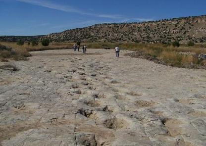
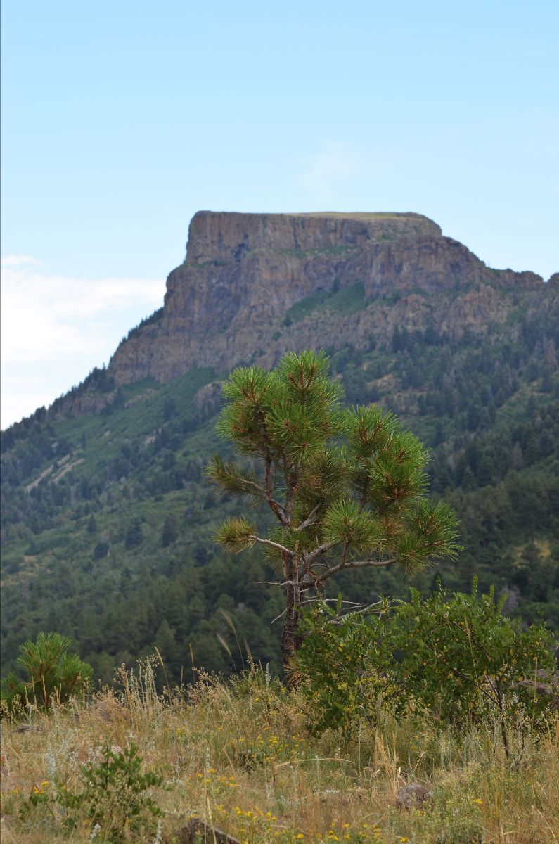
Dinosaur tracks in Picketwire Canyon. Photo credit: USFS
The only public access to the dinosaur tracks in Picketwire Canyon is by way of the Withers Canyon trailhead, an eleven-mile round trip. With the guided four-wheel tours suspended, you have three choices for mode of transport: mountain bike, horseback or on foot.
Bikers might think twice, after watching a few cautionary YouTube videos about the many, many goat’s head stickers and opportunities for flat tires. The horse option has some drawbacks, too; although most of the path is a level stroll along the canyon floor, the steep descent into the canyon on a rock-strewn trail and the purgatorial ascent at the end may not be something you want to do on top of a thousand-pound animal.
That leaves the third option, a six-hour hike in rugged and largely exposed country. Since temperatures in the canyon can be intense from late spring until early fall, reaching as high as 110 degrees in July and August, the Forest Service advises visitors to carry “at least” a gallon of water per person. (In 2017, two summer hikers died in separate heat-related incidents.) But on a temperate fall day, the startling, shifting environment of the canyon — from juniper-and-piñon prairie to meadows lined with cottonwoods to bright fields of yarrow and cacti in bloom — can make you forget you’re wandering through the northern edge of the Chihuahuan Desert.
For most visitors, the highlight of the journey is crossing the Purgatoire to arrive at a vast limestone plain, the stamping ground of monsters. The giant paw prints embedded in the ancient lake shore, back when the canyon was a lush, steamy tropical retreat, tell a story about lumbering, plant-eating apatosauruses traveling in gregarious herds, and the three-toed carnivores who stalked them. This quarter-mile stretch of the river is the most extensive set of dinosaur tracks in North America, yet it’s just a small portion of the Jurassic riches in the area; numerous fossils have been painstakingly unearthed by volunteers under the supervision of a Forest Service paleontologist.
The bones and tracks may be the main draw, but they’re hardly the only one. In 1988, a University of Wisconsin student on a field trip headed down from the west rim of the canyon to check out the dinosaur tracks. On the way down, he came across a petroglyph panel in a shallow alcove and snapped a picture of it. He assumed the panel was already well known to researchers. It wasn’t. According to Loendorf’s account in his book Thunder & Herds: Rock Art of the High Plains, when a wildlife biologist familiar with the canyon saw the photo, “he realized that he was looking at a significant and previously unknown site.”
The panel features a single human figure in the center, surrounded by three dozen quadrupeds — some with elaborate antlers, some suggestive of bison and sheep. The central figure holds an object in its right hand, possibly a net or snare, indicating a form of control over the animals. Loendorf regards the Zookeeper, as the panel has become known, as one of several key rock-art sites in the area that provide glimpses into the hunter-gatherer culture that once flourished there. He believes a climatic event more than 600 years ago, one that ruined crops and drove the game away, may have been responsible for its abrupt disappearance.
“You have these obvious hunt scenes, driving animals — antelope, probably — into nets, and then it just ends,” he notes. “It pretty much suggests that the Apishapa were affected, like all of the Southwest, by drought. I personally think at least some of the Apishapa people were seasonal and pulled back to the mountains in the wintertime. And the drought period ended that; then they stayed close to the mountains year-round. Then came the Apache and the Comanche. They weren’t dependent on trying to grow corn.”
Bosque del Oso State Wildlife Area via Sangres.com
FromThe Trinidad Chronicle-News (Eric John Monson):
Recently Great Outdoors Colorado (GOCO) awarded a $25,000 grant to Colorado Parks and Wildlife (CPW) to enhance solar water wells at Bosque del Oso State Wildlife Area (SWA), the largest SWA in Colorado at 30,000 acres.
The grant is part of GOCO’s CPW Director’s Innovation Fund (DIF), a partnership between GOCO and CPW. The program is designed to fund small-dollar, innovative projects across the agency.
Bosque del Oso currently has 11 solar water wells, but only three are in operation. The functioning wells are miles apart, and the two forks of the Purgatoire River that run through the property are on opposite ends. In addition, the lake and streams are typically dry by June each year, limiting water resources for wildlife and their habitat.
“Bosque del Oso is one of the largest jewels in the SWA portfolio,” said GOCO Parks and Wildlife Program Manager Emily Orbanek. “Water for wildlife in the Bosque del Oso is hugely important. There is not a ton of flowing water there. So, it is important to get the wells up and running and several of them have been out of commission for a while now.”
CPW will be responsible for completion of the work.
According to GOCO the funding will help CPW make improvements to four of the non-functional wells to ensure they operate properly. Some wells may need to be re-drilled, and large tanks will be installed to collect water for wildlife and prevent it from seeping into the soil. This will directly benefit all wildlife by creating proper access to water and will help distribute wildlife more equally across the property, enhancing hunting and viewing experiences.
A view of Fishers Peak from the property that will become Colorado’s next state park. Senate Bill 3 provides $1 million toward the park’s continuing development. Photo credit: Colorado Parks & Wildlife
Here’s the release from Colorado Parks & Wildlife (Rebecca Ferrell):
In the closing hours of the 2020 legislative session, Colorado legislators approved $1 million to support efforts to develop Colorado’s next new state park around iconic Fishers Peak near Trinidad.
The Colorado Legislature’s passage of Senate Bill 3 will provide critical funding to help Colorado Parks and Wildlife (CPW) develop trails and infrastructure on the 19,600-acre property that features Fishers Peak, a landmark that towers over Trinidad and guided pioneers along the Santa Fe Trail in the 1800s.
“We extend our sincere gratitude to the Legislature for recognizing the value of investing in Colorado’s state parks,” said Dan Prenzlow, Director of Colorado Parks and Wildlife. “As we’ve all worked through the many challenges of the COVID-19 outbreak, including budgetary challenges, one constant was the ability for people to center themselves a bit in nature while visiting our parks. Having this investment in our next state park will allow us to provide even more of Colorado’s outdoors to our residents and visitors.”
The funding authorized by this bill will support the early stages of the park’s infrastructure development. A master planning process that will guide future development of the park is also underway, involving community stakeholders and additional project partners The Nature Conservancy, Trust for Public Land, the City of Trinidad and Great Outdoors Colorado. While the property is not yet open to the public, CPW’s goal of providing initial public recreational access to a portion of the property by early 2021 remains in place.
“This initial investment in our 42nd state park would not have been possible without the strong advocacy and support of Governor Polis, Senators Leroy Garcia, Dennis Hisey, and Representatives Daneya Esgar and Perry Will, along with the businesses, local governments in Trinidad and Las Animas County and our non-profit partners,” said Dan Gibbs, Executive Director, Department of Natural Resources. “We came together during a difficult year to provide needed resources to move forward on what is going to be a signature and our second largest state park. I can’t wait to climb the flanks of Fishers Peak or try new mountain bike trails of this fantastic amenity which will serve as a draw for visitors and recreationists alike to explore the Park and other attractions of this incredible region of Southern Colorado.”
Though Senate Bill 3 has undergone several iterations as the state made adjustments for the costs of the COVID-19 pandemic, Gov. Jared Polis, the Colorado Department of Natural Resources and Colorado Parks and Wildlife remain committed to creating a state park with input from the local community, sportspersons and other conservation stakeholders.
The 9,633-foot summit of Fishers Peak looms over Trinidad. Photo courtesy of Colorado Parks and Wildlife / Bill Vogrin
The 9,633-foot summit of Fishers Peak looms over Trinidad. Photo courtesy of Colorado Parks and Wildlife / Bill Vogrin
From email from Colorado Parks and Wildlife (Bill Vogrin):
More than a year after entering a partnership to acquire a 19,200-acre ranch that includes the towering landmark known as Fishers Peak, Colorado Parks and Wildlife has completed the purchase, clearing the way for creation of the state’s 42nd state park.
The acquisition is especially significant as Coloradans prepare to celebrate Colorado Public Lands Day on Saturday, May 16.
“The state’s acquisition of Fishers Peak is an exciting milestone for Colorado outdoor recreationists, wildlife watchers, hunters and residents and businesses of Southern Colorado,” Governor Jared Polis said. “The COVID-19 pandemic has shown that Coloradans highly value their open spaces and outdoor recreation opportunities. Colorado was one of the few states to keep our state parks open during this entire crisis because recreating at a safe space outdoors is a healthy part of our lifestyles. Adding Fishers Peak as our next state park will increase opportunities to explore a unique and stunning part of Colorado.”
“I look forward to celebrating Colorado Public Lands Day this weekend and, in the months to come, opening Fishers Peak to the public with our important partners and local elected officials.”
In February 2019, CPW partnered with the City of Trinidad, The Nature Conservancy, The Trust for Public Land and Great Outdoors Colorado (GOCO) to purchase the mostly undeveloped property, prized for its variety of habitat, wildlife and the linkage it provides between grasslands to the east with foothills and mountains to the west.
The property includes the 9,633-foot summit of Fishers Peak, an iconic outcropping of ancient horizontal lava flows atop Raton Mesa, which has served as a landmark for Native Americans, a beacon for pioneers moving west and a waypoint along the historic Santa Fe Trail connecting the Eastern U.S. to New Mexico and the Southwest.
The Fishers Peak property also is valued for the wildlife it shelters, including native species like elk, mule deer, white-tailed deer, mountain lion and black bear. And it preserves important migration corridors between their populations in the mountains and those on the prairies.
On April 2, the partners signed over ownership of the property to CPW. With the deed in hand, CPW leadership and the partners immediately ramped up master-planning efforts to create a new state park that will protect the natural treasures and wildlife found there while welcoming visitors, including hunters, campers, hikers, mountain bikers, wildlife watchers, rock climbers and other outdoor enthusiasts.
“We are grateful to our partners for all their work securing the property for future generations of Coloradans and visitors,” said Brett Ackerman, CPW Southeast Region Manager. “Great teamwork has gotten us to this point. We at CPW look forward to completing the master-planning process and meeting the governor’s goal of opening Colorado’s next state park.”
“We are pleased to finalize this sale of the property to CPW in these trying times,” said Carlos Fernandez, Colorado State Director for The Nature Conservancy. “Over the past weeks, it’s become even more clear how important access to nature is to all people, providing solace, hope and community. I’m proud of the Conservancy’s efforts with partners to steward this project from the beginning to where we are now, one step closer to Colorado’s next state park.”
“It’s become more evident than ever that access to the outdoors is an important part of everyone’s physical and mental well-being,” said Jim Petterson, The Trust for Public Land’s Colorado state director. “This new state park will give the people of Colorado an exceptional place to get outside to heal and connect with nature, their community and each other.”
“GOCO is a proud partner in this once-in-a-lifetime opportunity,” said GOCO Executive Director Chris Castilian, whose agency provided the bulk of the funding, $17.25 million, toward the acquisition. “It’s been our honor to be a proponent and primary funder of this amazing project to date, and we look forward to supporting our partners at CPW to bring a vision for this state park to fruition.”
“The City of Trinidad strongly supports Colorado Parks and Wildlife’s acquisition of the Fishers Peak property and the partnership that made this new state park a reality for our city and Las Animas County,” said Trindad Mayor Phil Rico.
For now, the property remains closed to public access. But CPW intends a phased approach to opening that will allow limited public access to the property while the master-planning process proceeds and a full state park is developed.
The public can follow the park’s progress and get updates on participating in the planning process at cpw.state.co.us.
In 2016, Colorado became the first state to establish a holiday for our public lands. Colorado Public Lands Day focuses on how our public lands are central to the state’s economy and our quality of life.
The COVID-19 crisis has impacted Colorado’s outdoor recreation economy and we all must adapt and celebrate public lands while remaining socially distant. As a result, Colorado Public Lands Day activities this year will highlight art, film, educational webinars and community conversations to offer a variety of ways that Coloradans can meaningfully connect with one another as well as our precious lands and waters. Learn more about Colorado Public Lands Day here: https://copubliclandsday.com.
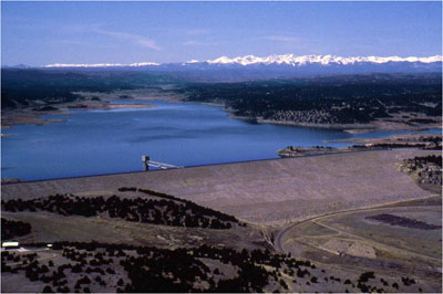
This view is from the top of John Martin Dam facing west over the body of the reservoir. The content of the reservoir in this picture was approximately 45,000 acre-feet (March 2014). By Jaywm – Own work, CC BY-SA 4.0, https://commons.wikimedia.org/w/index.php?curid=37682336
Here’s the release from Colorado Parks and Wildlife (Bill Vogrin):
Colorado and Kansas sign historic agreement for a permanent water supply at CPW’s John Martin Reservoir State Park
A 40-year deadlock between Colorado and Kansas has been resolved with the signing of a historic agreement that will provide a new source of water for a permanent fish and wildlife conservation pool in John Martin Reservoir.
The long-sought compromise between members of the Colorado-Kansas Arkansas River Compact Administration will allow the Lower Arkansas Water Management Association (LAWMA) to transfer water from the Highland Canal on the Purgatoire River in Bent County into John Martin Reservoir on behalf of Colorado Parks and Wildlife (CPW) to maintain a permanent pool for fishery and recreation purposes.
The permanent agreement, approved by the Compact Administration on Feb. 14, began as a one-year pilot program in 2017 when CPW was allowed to run 6,000 acre feet into the reservoir. The newly approved agreement will allow water to be delivered each year from the Highland Canal from March 1 through Nov. 15.
The agreement is the culmination of decades of negotiations between a variety of agencies including CPW, the Colorado Division of Water Resources, the Kansas Division of Water Resources, the Colorado Water Conservation Board, LAWMA and the Attorney General’s office. It was brought to fruition through extensive collaboration between the State Engineers of Colorado and Kansas.
“CPW has worked for the past 40 years to get a new source of water approved by the Compact Administration,” said Dan Prenzlow, CPW’s Southeast Regional manager who directed the breakthrough negotiations together with Deputy Regional Manager Brett Ackerman. “John Martin Reservoir is a multimillion-dollar fishery and source of water recreation, camping, hiking and wildlife watching.”
In fact, visitors to John Martin spend an estimated $8.7 million a year in local businesses, making John Martin an important economic engine in the region.
“But it has constantly been in flux and at risk,” Prenzlow said. “This agreement will stabilize the valuable fishery and recreational facilities at John Martin Reservoir State Park and State Wildlife Area.”
Prenzlow listed several significant benefits to the new agreement, including:
Reducing the hundreds of thousands of dollars CPW has spent leasing Colorado River water to fill the conservation pool in previous years.
Lowering the risk of fish loss, saving CPW approximately $165,000 annually in restocking costs when the fishery is damaged.
Providing more consistent boating recreation, especially in drought years.
Prenzlow noted that visitation at John Martin drops as dramatically as the water levels fluctuate at the reservoir, which was built as a flood-control structure and completed in 1948. In wet years, the waters of John Martin can spread out to 11,000 surface acres. But in drought years, it’s not uncommon for surface acres to plunge to just 1,000. That was the case during extreme drought years of 2011-15.
“We are proud to achieve this agreement because we know the importance of a healthy John Martin Reservoir to Colorado anglers, boaters and surrounding communities,” Prenzlow said. “A consistent flow of water into John Martin will keep the boat ramps at John Martin wet and that will mean a consistent source of recreation for boaters, anglers, water skiers and campers in the park and region.”
The Bureau of Reclamation will extend the repayment contract for Trinidad Lake to 75 years because prolonged drought has reduced the anticipated use of storage in the reservoir. The reservoir, formed by the completion of Trinidad Dam in 1977, was built by the Corps of Engineers for flood control, but the project also includes recreation and wildlife values, as well as an irrigation contract between Reclamation and the Purgatoire River Water Conservancy District. The contract dates back to 1967 and the original debt was $6.46 million.
The construction of Trinidad Dam was a matter of dispute when Kansas sued Colorado over violations of the Arkansas River Compact in 1985. The compact commission reviews operating principles at the lake every 10 years.
“The contract repayment is tied to water supply, and we determined the contract could not be repaid over 70 years, so we extended it to 75 years,” Andrew Gilmore, Reclamation engineer, told the compact commission this week.
He explained that several years of drought, including just a 17 percent of average snowpack in the Purgatoire River basin last year, have reduced payments by the district to a minimal level.
Meanwhile there is a request by the city of Trinidad to store water from outside the Purgatoire River district boundaries in the lake. Jeris Danielson, manager of the district, supported using more capacity in Trinidad Lake, which has a capacity of 125,967 acre-feet, with 20,000 acre feet set aside for irrigation, municipal and industrial storage contracts. Flood control is 50,000, while a joint use pool is 39,000 acre-feet. However, the reservoir often does not contain much more than the permanent pool of about 16,000 acre-feet set aside for fish and wildlife. The current level is about 14,400 acre-feet.
Danielson told the commission flooding has rarely occurred and more conservation storage could be used.
“In the joint use pool there is 35,000 acre-feet of storage that goes unused each year,” Danielson said. “It’s an incredible resource that just sits there.”
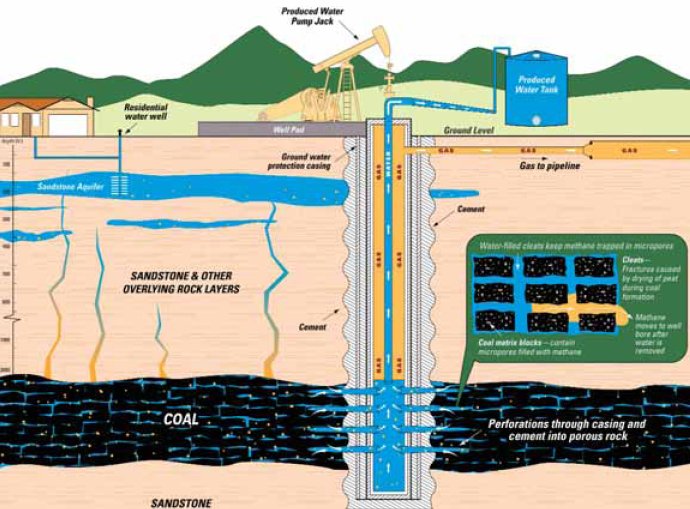
The damage to farm ground caused by water released from gas wells has been lasting while state protection has proven elusive for Huerfano County dairy farmer Brett Corsentino. “I can’t raise feed and I can’t hold anyone accountable. The bottom line is that the state agencies failed to protect me,” Corsentino said. “It’s all about the money these gas companies have. There’s no way to pierce the corporate veil.”
Corsentino farms is in the Cucharas River basin, which is north of the Apishapa and Purgatoire river basins where oil and gas exploration is most active in Southern Colorado. Pioneer Energy and XTO Energy are active in the lower watersheds. They are engaged in studies to show the water quality is sufficient in some cases for release into streams. Some landowners in the Apishapa and Purgatoire watersheds have asked the Colorado Department of Health and Environment to allow CBM releases.
But Corsentino said he was blind-sided by releases from Petroglyph Energy that began in the Cucharas basin in the late 1990s. He claims the water was high in salts and barium, which broke down the soil on his farm. “I used that water and put it on my fields, but didn’t know about (the releases) until 2006,” he said.
The productivity of his soil fell to one-third of its former level, and one-time soil amendments were paid for by Petroglyph. But the state never followed up with testing, and the Oil and Gas Commission said he had proven damage. “It was a joke. Sucks to be me,” Corsentino said.
His warning to other landowners is clear. “There have been four generations of my family here since my greatgrandfather came over from Sicily in 1905. It’s a hard life. We’ve taken care of the ground and it’s taken care of us,” Corsentino said. “We’ve gone through a reorganization, and I’ve lost the equity. At this point, I just want to be able to raise feed for my animals.”
Some Las Animas County farmers and ranchers in the Apishapa River basin are concerned that releases of water from oil and gas drilling could render cropland useless. They want water tested — and even treated — before it is released into the river system, saying the danger of increased salinity outweighs any benefit of more water during a drought. “Our main concern is that what happened in Huerfano County doesn’t happen to our soil,” said Gary Waller, who holds senior water rights for fields he irrigates near Aguilar. “We want to be proactive and make sure we do not get contaminated.”
Ken Valentine, whose family irrigates further up in the basin, said a spring above one of its fields was potentially contaminated by a release from coal-bed methane drilling last year. He is also alarmed that CBM water is routinely sprayed on gravel roads throughout the area. “The water should be treated before it’s released into the watershed, either at the company’s expense or those people who are using it for things like livestock ponds,” Valentine said.
They want to avoid the types of troubles Huerfano County dairy farmer Brett Corsentino experienced when Petroglyph Energy dumped CBM water into the Cucharas River in the late 1990s. Water high in salinity and barium ruined his farm ground. “I was harvesting 18-21 tons of corn silage per acre before, and it dropped to six tons after,” Corsentino said. “They ruined my way of life, and the state agencies turned a mute ear to my complaints.”
While the Colorado Oil and Gas Conservation Commission required Petroglyph to stop dumping water in 2006 and to help Corsentino try to restore farmland, it ruled in 2011 that Petroglyph no longer had any liability. All say the state should be insisting the water produced by Pioneer Natural Gas in the Apishapa River basin is either of equal quality to surface water, and reinjected into deep wells if it fails to meet standards.
While some in the area contend the water is suitable for livestock and wildlife, the farmers fear it will contaminate their fields — particularly during a drought when there is less natural surface water to dilute the effects. “If the water is good, it should be utilized,” Waller said. “But if it’s not, it will get into the groundwater and onto our place eventually.”
Meanwhile, oil and gas producers in the Purgatorie River watershed have asked the state to relax standards for discharged water. Here’s a report from Steve Block writing for The Trinidad Times. Here’s an excerpt:
A leader of a regional environmental protection group said she’s deeply concerned about the possible lowering of water quality standards in the Purgatoire River Watershed, and asked the Las Animas County Board of Commissioners to write a letter to the Colorado Water Quality Commission, protesting the potential change.
Paula Ozzello of the Southern Colorado Environmental Council (SCEC) spoke at Tuesday’s board work session about the potential dangers of the reduction in water quality standards.
Ozzello, chairperson of SCEC, said XTO Energy and Pioneer Natural Resources have proposed to the commission a reduction in water quality standards for the Lower Arkansas River Basin, specifically the Purgatoire River Watershed and the Apishapa Watershed. She said the XTO and Pioneer proposal would reduce the surface water quality standard, by increasing the allowable level of boron in water used for agricultural purposes from its present level of 0.75 milligrams (mg) per million to a new, and higher, standard of 5.0 mg per million.
Trinidad Lake, west of Trinidad, is the result of state legislation more than 50 years ago. The Purgatoire River Water Conservancy District was created by the state Legislature on Dec. 2, 1960. The district is capable of contracting with the United States for repayment of the irrigation, municipal and industrial uses of the Trinidad Project and to provide a management entity to oversee the project.
Other responsibilities include: Surveying existing water resources and basin rivers; taking actions necessary to secure an adequate supply of water — present and future; constructing water reservoirs; entering into contracts with other water agencies, (such as the Bureau of Reclamation), organizing special assessment districts, providing for instream flows for fisheries; and other legal responsibilities needed by the district to fulfill its purposes.
On Feb. 10, 1967, the district executed a repayment contract with the United States whereby it assumed a debt of $6.46 million to be repaid over a 70-year period.
The main feature of the Trinidad Project is Trinidad Dam, located several miles west of Trinidad on the Purgatoire River in Las Animas County. The dam, which was constructed by the Army Corps of Engineers, is of earth-fill construction — having a height of 208 feet above the stream bed and crest elevation of 6,298 feet. Trinidad Lake, the reservoir created by the dam, has a total capacity of 125,967 acre-feet, which is allocated to the following uses:
Flood control: 51,000 acre-feet
Irrigation, municipal and industrial: 20,000 acre-feet
Permanent recreation and fishery: 15,967 acre-feet
Joint use and sediment pool: 39,000 acre-feet
The irrigation and joint use pools are utilized to provide storage for irrigation by 10 project ditches that irrigate up to 19,499 acres in the project area, for municipal use by the city of Trinidad and for recreational use by the Colorado Division of Parks and Wildlife. Each of the participating ditches have repayment contracts with the district and make annual payments based upon available water during the year.
The district retains operational control of all water rights owned by the ditches and allocates water available on an equitable basis to all project acres. Once the reservoir is declared empty by the district board, exercise of the water rights reverts to the respective ditches under normal priority administration.
Jeris Danielson is general manager of the Purgatoire River Water Conservancy District.
Hundreds of coalbed methane wells in Las Animas County could produce water that could be used for other purposes in the Arkansas River basin, a study shows. A twoyear waterquality monitoring program is showing the “produced water” — water that must be removed from coal seams to extract natural gas — is within limits for harmful contaminants like dissolved solids, conductivity, chloride, sodium, boron and iron, Julie Vlier, of Tetra Tech told the Arkansas Basin Roundtable Wednesday.
“Based on the collection data of the last two years, the quality is quite good,” Vlier said. “Concentrations in the Raton
Basin are lower.” The water quality question is important to companies like Pioneer Natural Resources and XTO Energy, which otherwise would have to spend more to inject the water back into the ground. The companies funded the study, which began in 2010. Pioneer alone has about 2,300 gas wells in the Raton Basin, said Jerry Jacob, environmental advisor for the company.
If the water can continue to flow freely into tributaries leading into the Purgatoire River west of Trinidad, it could increase the yield of existing water rights or even improve Colorado’s position in the Arkansas River Compact. Vlier also said the water could help in drought planning or fire mitigation.
The energy companies have state permits that would allow the release of up to 14,000 acrefeet — or 4.5 billion gallons — of water annually. Not all of it would likely reach the Purgatoire River, but it could be used to enhance existing water supplies.
Not everyone on the roundtable agreed with the rosy assessment for produced water.
“They’re taking water out of the same formation as Petroglyph,” said Al Tucker, a member of the Majors Ranch Environmental Committee, who represents Huerfano County on the roundtable. Landowners in Huerfano County say their wells were adversely affected during Petroglyph’s operations, which ended in 2011. In addition to contamination of groundwater, the company may have taken water out of priority, Tucker said.
The Culebra Range Community Coalition brought together Colorado Watershed Assembly officials and representatives of environmental engineering consulting firm Tetra Tech at Trinidad State Junior College. Tom Perry, executive director of the coalition, said the group hopes to deepen stakeholders’ involvement in protecting the watershed. In a [November 4] phone call, Perry talked about working more closely with the members of Trout Unlimited, the Purgatoire River Watershed Coalition, the Trinidad Community Foundation and other local partners to make the watershed as healthy as possible…
Some key findings from the initial monitoring season showed water quality protects the Purgatoire River for such beneficial uses as agricultural irrigation, livestock and wildlife watering. Clean water also benefits aquatic life and municipal water systems.
Monthly data is collected at 27 sites along the Purgatoire and its tributaries upstream of Trinidad Lake. Streamflow and water quality data are communicated in near real-time using satellite telemetry from nine of the sites’ monitors and can be viewed at purgatoirewatershed.org, a potential resource to better understand surface water quality influence for ranchers, farmers and recreation industry employees.
More Purgatoire River watershed coverage here and here.
Here’s a in-depth look at drying up agriculture to water suburbs, from Bruce Finley writing for The Denver Post. Click through and read the whole thing. Here’s an excerpt:
“You get kind of nervous when you have people who are on the New York Stock Exchange saying they’re going to put agriculture back into production,” said Jay Winner, manager of the Lower Arkansas Valley Water Conservancy District, devoted to retaining farming water rights across a five-county area. “I’m skeptical,” Winner said, “because from the amount of money they’re sticking into this project, it looks like it’s a big agriculture-municipal transfer.”
When pressed, Two Rivers’ [Gary] Barber acknowledged that the $27 million deal was indeed done with an eye toward eventually selling water to suburbs.
The stealthy and not-so-stealthy shifting of control over Colorado water has continued despite economic doldrums and may be gaining momentum. Farmers often are willing participants, cashing in as relative scarcity makes water more valuable.
Among recent deals:
• Pueblo bought the Bessemer agricultural canal.
• Aurora, Thornton, Brighton and Adams County invested in the Fulton Ditch northeast of Denver.
• Cherry Creek and Arapahoe County water authorities, though still facing court scrutiny, have staked claims to water once allocated for farming.
Also, in the Colorado Springs area, the Donala Water and Sanitation District, which bought a 711-acre ranch near Leadville for its water rights, now is pursuing a change-of-use ruling in state court so that farming water could be harnessed for Front Range housing and lawns.
Similarly, satellite cities Fountain and Widefield spent $3.5 million to acquire developer Mund Shaikly’s 480-acre H2O Ranch at the base of the Sangre de Cristo mountains. The plan is to sustain an anticipated military housing boom by using mountain creek water that once irrigated hayfields. Fountain will let the creek water flow into the Arkansas River, then trap it in Pueblo Reservoir, said Fountain water engineer Curtis Mitchell. “Certainly we’re not in the land business.”
North of Colorado Springs, Woodmoor’s new 1,900-foot-deep municipal wells appear uncertain enough that suburban leaders are mobilizing to buy water rights from farmers in the Arkansas River Valley and plan to construct a delivery pipeline.
Along the Arkansas River, state records indicate suburbs petitioned courts at least 116 times over the past decade to convert agricultural water for municipal use.
Here’s a report about Crowley County and the after effects of Aurora’s purchase of the Rocky Ford Ditch, from Mr. Finley and The Denver Post. From the article:
Concrete-lined irrigation ditches that once delivered water now are bone-dry. Draining water that once irrigated crops to supply suburban housing, lawns and golf courses makes it impossible for farms and the towns that depend on farming to survive. “Once you move water out, it ain’t coming back to the land,” the 74-year-old Valliant, now an irrigation specialist for Colorado State University’s Cooperative Extension station in nearby Rocky Ford, said recently as he rolled past the weeds and a slumping farmhouse surrounded by garbage.
Built in the 1890s, after the Missouri Pacific Railroad and the Colorado Canal were completed, Crowley and its neighbors prospered growing sugar beets, with canning plants, grain elevators, schools, newspapers and even an opera house. One company here broke wild horses and supplied the British army. Residents reveled in a pioneer spirit of transforming a harsh environment — average annual rainfall 12 inches — into a livable town. But farmer debts mounted after a sugar-beet plant closed in 1967. Some farmers eventually gave in as water brokers representing expanding cities approached them offering deals. Today, Crowley ranks among the poorest towns in the poorest county in Colorado. The town population is dwindling — to 162 today from 187 in 2000 — continuing a decline that began when Foxley and others in the 1980s sold off their water.
Las Animas County’s four largest gas companies — Pioneer Natural Resources, El Paso E&P Company, XTO Energy and Red River Ranch Holdings — have implemented SWSPs in order to continue gas production in the about 3,068 CBM wells operating within the central Raton Basin. Industry activities in the area discharge from CBM wells a combined total of about 10 million gallons of produced water per day. The SWSPs were approved by the State Engineer’s Office through March 31, 2011 and are nearing the end of their first approved year of implementation. The SWSPs call for replacement water to come from, “a lease with the City of Trinidad to supply up to 50 acre-feet of fully consumable water from the city’s storage account in Trinidad Reservoir.”[…]
A summer 2009 decision by the Colorado Supreme Court in the Vance v. Simpson case determined that the groundwater produced during CBM drilling production, previously considered a waste by-product, was of “beneficial use,” and thus had to undergo permitting and comply with Colorado groundwater laws. The state then passed an authorization for the State Engineer’s Office to approve alternates such as SWSPs in place of augmentation plans. That authorization for alternates extends from March 31, 2010 to Dec. 31, 2012 in order to provide energy companies in Colorado with extra time to integrate CBM wells that withdraw waters considered tributary and that impact “over-appropriated” streams into the state water court’s adjudication process.
Colorado Division of Water Resources Division 2 Engineer Steve Witte told The Times Independent that the Division had turned down initial requests by the companies to utilize the non-tributary water component of the CBM produced water as a replacement source. “The concern that we have is the native tributary water supply that water rights along the Purgatoire (River) depend upon are not diminished by the withdrawal of groundwater,” Witte said. “The initial proposal was that, of the water that they withdraw from the coal beds, they determined that a portion is tributary and a portion is non-tributary, and they thought that they would simply rely on the non-tributary water as a replacement for the stream depletions that were calculated.
The designer of the river enhancement project is FIN-UP Habitat Consultants, of Manitou Springs, and the project is titled “Trinidad/Purgatoire River Reach 4 Demonstration Project.” The design process is unique in that it doesn’t use much water. The design utilizes existing water during low-flow periods and accentuates the water available during the irrigation season. Lackey said bringing off a project of this size is difficult during tough economic times but said the partnership that has been put together has managed to fund the project with no public funding. The river reclamation project is estimated to cost between $120,000 to $150,000.
“That’s a very big deal for us. The partnership has been with the Purgatoire River Conservancy District, which actually owns the water. The dam up there was built in the 1970s to irrigate the farmland east of town. They have committed $90,000, and that’s a lot of money. Then Pioneer Natural Resources got on board. They are a big contributor to the county and to its economy, and they are also very interested in this river project because it reflects on their stewardship of the watersheds west of town and east. Pioneer has come to the table with $40,000. So at this point we have acquired enough funding and in-kind services to complete the project from I-25 all the way to North Commercial Street and a little bit east. That’s an exciting start. Comcast has been on board with us since the second year with the river cleanup and they have been a big part of that. Trout Unlimited, without their contacts and the people who were visited, this probably would not have happened. The Trinidad Community Foundation has also been very important.” Other partners include Purgatoire Valley Construction, MFS Forestry, Colorado State Forest Services, the Soil and Conservation Services, the U.S. Army Corps of Engineers, and, most importantly, the citizens of Trinidad.
April 30 marks the fifth annual river cleanup. Last year 232 volunteers helped with the cleanup, and this year Lackey said he hopes for 250 or more volunteers. “It’s a fun thing to do for everybody involved. Bring the kids. They can learn about some of the river ecology, pick up a lot of trash, and learn a little bit about what it’s going to take care of a jewel that Trinidad has never really abused, it has just never used. It’s going to be a great addition to the downtown area. So, we’ll see everybody on April 30 with their irrigation boots on and a trash bag, and we’ll ‘git ’er done’”
More Purgatoire River watershed coverage here and here.
…a few, like Chapter President Howard Lackey, could see beyond the trash and invasive plants and envision the potential of the Purgatoire River as a trout steam. Howard’s grandfather taught him the best way to recover from a stressful day of work is to take out the fly rod, and that is easier to do with a stream near where you work and live. The Trinidad Community Foundation was founded in 2006, with a mission to improve the quality of life in Trinidad and Las Animas County. Howard was on the board of directors, and one of the first projects tackled was improving the river corridor. The Foundation began a spring clean-up of the river corridor. They partnered with The Comcast Foundation, and this spring over 230 people volunteered at the Comcast Cares clean-up event.
Members from Chapter 509 Southern Colorado Greenbacks in Pueblo had become interested in the Purgatoire River a couple of years ago, and toured it with city officials and Kim Pacheco Schultz, the Executive Director of the Trinidad-Las Animas County Chamber of Commerce. They were excited by the possibilities but knew it would be difficult to work on a project 75 miles away. Chapter 509 generously off ered to allow a new TU chapter to form in their southeastern Colorado territory. A meeting was held in September 2009 to measure the local interest, and Chapter 100, Purgatoire River Anglers, came into being that night.
More Purgatoire River watershed coverage here and here.
The project’s origins stretch back to about five years ago with the Trinidad Community Foundation (TCF) and has grown since to include a multitude of active and supporting partners such as Trout Unlimited, The Nature Conservancy, the Spanish Peaks-Purgatoire River Conservation District, the Colorado Division of Wildlife, the City of Trinidad, the Tamarisk Coalition, private landowners and host of other agencies and groups. “We were talking about how the Purgatoire River, from the dam all the way through the town, was a very under-utilized resource. When the (TCF) got together, one of the tenants of their reason for being was recreation within the area,” TCF and Purgatoire Anglers chapter of Trout Unlimited member Howard Lackey said. “I took the project with the river as kind of our banner project for recreation.”
The focus on the Purgatoire River commenced with the regular cleanups that are still ongoing through the efforts of a small army of volunteers, including local Comcast employees. “This year, I think we had 232 volunteers,” Lackey said. “Part of what the neglect of the river corridor was, was that a lot of invasive species were allowed to take hold. Russian olive is a very prolific and water-thirsty plant, so it has a tendency to concentrate along wet areas and streams banks. It chokes out the native flora, which was willow, cottonwoods, all that kind of stuff that was here 200 years ago before the Russian olive.”[…]
“It’s not so much that the Purgatoire has been abused, it’s just been ignored,” Lackey said. “We’ve had a lot of people that have kicked in, and then The Nature Conservancy started with it, and the Purgatoire River Conservancy District…got interested in the process to clean up the river, and it helps the delivery of water to their irrigators.”[…]
The second phase of the current project would begin with the repair of the river area from damage caused by illegal ATV traffic, trash and illegal dumping. Examples of the latter two problems are easily seen by even a casual stroll through much of Trinidad‘s river area. “We’d like to bring it back to a natural state that would allow for nature trails on the north side that would include not only the hiking, but also possibly areas where we could define and meet the natural flora and natural wildlife,” Lackey said. “The part of the trail system, called the Boulevard Edition, which is west of I-25…that’s a part of the river that’s been extremely abused; just out of control four-wheel usage that’s torn up the landscape. At our cleanup this year we took two-and-a-half 40 yard rolloff (dumpsters) of crap out of there.”
Plans then call for developing the river to include a fishery, making the stretch around and through Trinidad conducive to recreational fishing. “That’s where the Trout Unlimited comes in,” Lackey said. “The Trout Unlimited group have engaged a stream engineer that is taking a look at the flows of the Purgatoire between low and high to decide how we can design the stream to make it conducive to a trout fishery.”
Lackey described the goal of a successful design as creating “a streambed within a streambed. We have to design for two different flows: one which is a very low flow—anywhere from three (cubic feet per second – cfs) to 10 cfs — then a very high flow up to 400 cfs to 500 cfs,” Lackey said. “We kind of are envisioning a channel following the natural flow of the water, and enhancing it with rock structures, bank structures, things that will have a conducive environment for trout during low water segments, and then once the water (level) comes up, it will go outside those banks and increase more areas for the fish to inhabit.”
During the summer months, plans call for cooperation with the Colorado Department of Wildlife to utilize parts of the river for a stocking program. “That will give access to kids and older adults to deal with the fish within the city limits,” Lackey said. “The state usually stocks rainbow (trout), but we’d like to have a reproducing population of brown trout, eventually. Of course, that will take some time.”
Trout Unlimited hopes to develop fisheries in the river from east Trinidad up to the base of the Culebra Range, through the Purgatoire River’s south, middle and north forks and “anything in between. It’s a large area that’s basically been undeveloped for years and years. The south fork is turning into a pretty decent fishery through the efforts of the Department of Wildlife in the designation Bosque del Oso Wildlife Area,” Lackey said.
More Purgatoire River watershed coverage here and here.
The study, which is to be conducted beginning this month and stretch through June 2010, will seek to compile current and historic stream flow levels; characterize the quality of ground and surface waters in the river basin; determine the relationship between coalbed methane (CBM) “producing intervals” – a given time period when a production wellhead is working – aquifers and surface formations, and create a groundwater-level monitoring system and determine the hydraulic storage capacities of the bedrock (how much water it can hold) and alluvial aquifers (those formed by deposits of things such as sand and silt).
“This is really a follow-up to a stream depletion analysis that was done by multiple state agencies – the Colorado Oil and Gas Conservation Commission (COGCC), the Division of Water Resources and our own agency,” Colorado Geological Survey (CGS) Senior Hydrologist Ralf Topper said in an Aug. 21 interview. “That was a first look at trying to answer the question, is there an impact from CBM production on water rights? That study indicated that, yes, there was an impact to stream depletion.”