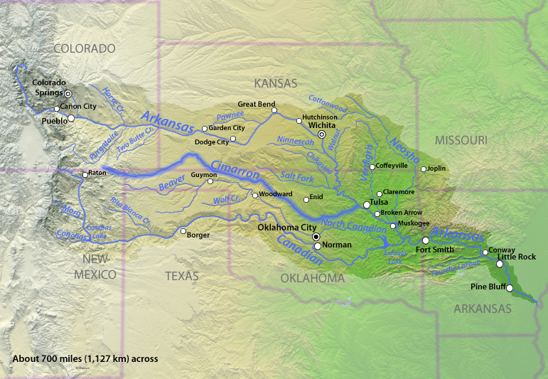
If nothing else, [Wes] McKinley’s crusade has brought attention to the profound disconnect between the emerging water crisis in eastern Colorado and a state policy that encourages total depletion of the resource. The surface water in virtually all of the state’s major river basins, from the Colorado, Arkansas and Rio Grande rivers to the humblest creeks, has been over-appropriated for decades. The major source of non-tributary water in the Far Quarter is the High Plains Aquifer, also known as the Ogallala Aquifer. Farms and ranches have been draining the aquifer, a vast underground reservoir of fresh water stretching across eight states, at an accelerating rate, despite warnings that the overpumping is likely to have catastrophic effects on fish habitat, interstate compact agreements and the sustainability of the aquifer itself, which requires centuries to recharge.
The warnings have been trickling through Baca County for more than fifty years. A 1966 study of groundwater in the area of the Cimarron River, which cuts across the southeast corner of Colorado and then vacillates between Kansas and Oklahoma, concluded that “the most serious problem in the Cimarron Basin appears to be the extreme decline of water levels from pumping.” A 2001 report prepared for the Southern High Plains Groundwater Management District noted that groundwater levels in the district had dropped a hundred feet in the past half-century; the report recommended a moratorium on all new and replacement wells in the High Plains Aquifer, except for domestic wells with a modest pumping rate of 15 gallons per minute.
Yet no moratorium was ever put in place. Instead, the Colorado Ground Water Commission has continued to issue large-capacity well permits like they were gimme caps. Data provided by the Colorado Division of Water Resources indicates that the commission granted 64 permits for new wells in the Southern High Plains in the last 21 months — a rate that’s more than triple the average number for the previous five years.
“Colorado does not have a statutory directive that impact to an aquifer needs to be considered when issuing a well permit,” says Kevin Rein, the state engineer, who also serves as executive director of the groundwater commission.
Long-range studies about climate change and dwindling aquifers don’t figure in the permitting process, which is preoccupied with mundane questions of how many other wells are operating within half a mile of the new well and whether an immediate neighbor would suffer “material damage” from additional pumping. McKinley contends that the rules as currently written don’t adequately protect the resource and shift the burden of proof to the opponents, who have to show that their own water rights would be adversely impacted by a new well. But Rein points out that some groundwater management districts have successfully petitioned the commission for a declaration that their area is over-appropriated, a finding that prevents the issuance of new well permits.
“That has happened in many of the basins, but it hasn’t happened in the Southern High Plains,” Rein observes. It isn’t the commission’s place to get involved in promoting such prohibitions or seeking changes in the law that would protect the High Plains Aquifer from more wells, he adds: “As the state engineer, I don’t have the charge to bring that sort of policy discussion.”
Water attorney Curtis estimates that McKinley’s objections cost his clients $200,000 in legal expenses and delays. McKinley’s time would have been better spent, he suggests, gathering the required technical data to petition the commission to close the district to new wells.
“Water rights are vested property rights, and you can’t strip someone of those rights without a proper basis,” Curtis says. “He knows the process. Either he doesn’t have the energy to do it the right way or he doesn’t care. But he never presented a single piece of relevant evidence to support his position.”
A major factor in the recent surge of permits in Baca County is a ramping up of irrigation wells on the Cimarron Valley Ranch, a 45,000-acre cattle ranch that stretches along 22 miles of the Cimarron River in Oklahoma and Colorado. Owned by Georgia-based LGS Holding Group, the property is for sale for $39,900,000, reduced from $45 million. An online real estate listing touts “some of the best hunting in the country,” including the ranch’s resident elk herd, as well as “incredible diversity in regard to terrain, wildlife, livestock grazing, income opportunities and more.” Also prominently mentioned is the ranch’s ample water supply and new well permits, which will allow the operation to double its number of irrigation pivots.
The mega-ranch’s wells account for nearly half of the permits the commission has issued in the Southern High Plains over the past two years. That rankles local rancher Dan Caldwell, a longtime friend of McKinley’s, whose property lies just across the state line from the Oklahoma stretch of the Cimarron Valley Ranch. Caldwell says that he, too, filed an objection to the LGS permits, but was told he hadn’t proved material damage — and that he could be liable for legal fees if he persisted. He knew his objection wasn’t going anywhere, he says, when he learned a representative of the Colorado Attorney General’s Office was joining the case —representing the groundwater commission, not the citizens of Baca County.
“We have no recourse,” Caldwell says. “We are nothing to them. There’s no reason to give our water away so freely, but they’re doing it.”
The Southwest Kansas Groundwater Management District also protested the LGS applications, on the grounds that new pumping along the Cimarron River was bound to diminish supplies downstream. A few years ago, Kansas won a long-running lawsuit concerning Colorado’s excessive water use under the Arkansas River Compact, but no such compact exists regarding the Cimarron.
“Colorado has a presumption that there’s water available for any application unless there’s a hearing,” notes Mark Rude, executive director of the district. “We had to become an opposer of the application in order to be involved in the hearing process. We’ve since discovered that Colorado works to not have a hearing process.”
Like Caldwell and McKinley, Rude was told there wouldn’t be a hearing because he lacked the legal standing to object. Southwest Kansas no longer permits new wells that would draw upon the High Plains Aquifer out of concern over the falling water table. But neither Colorado nor Oklahoma has followed suit.
“We have tools in Kansas to propose reductions in allocations, just to make the water last a little longer,” Rude says. “But it’s hard to have those conversations locally when people say, ‘Well, it’s unrestricted in Colorado and the Oklahoma Panhandle.’”
Rein calls the recent spike in permits in Baca County “anomalous” and doesn’t see any particular cause for concern in the recent water enhancements at a 45,000-acre ranch. “Certainly, some people in the basin are alarmed,” he says. “Is the commission alarmed? I don’t think we’ve had open discussion about that.”
McKinley doesn’t know what his objections might have accomplished, but he hopes more people will ask questions about where the water is going. “You don’t know what works and what don’t,” he says. “I’ve always thought there’s nothing wasted; it’s an experience gained. Sometimes, though, you pay a lot of tuition and wonder what you’ve learned.”
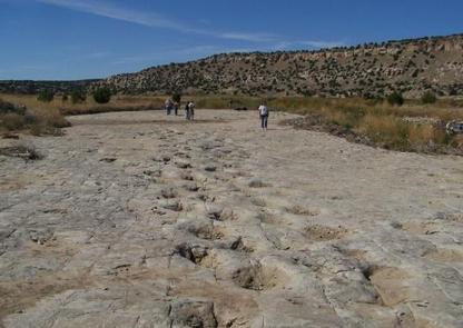
Dinosaur tracks in Picketwire Canyon. Photo credit: USFS
The only public access to the dinosaur tracks in Picketwire Canyon is by way of the Withers Canyon trailhead, an eleven-mile round trip. With the guided four-wheel tours suspended, you have three choices for mode of transport: mountain bike, horseback or on foot.
Bikers might think twice, after watching a few cautionary YouTube videos about the many, many goat’s head stickers and opportunities for flat tires. The horse option has some drawbacks, too; although most of the path is a level stroll along the canyon floor, the steep descent into the canyon on a rock-strewn trail and the purgatorial ascent at the end may not be something you want to do on top of a thousand-pound animal.
That leaves the third option, a six-hour hike in rugged and largely exposed country. Since temperatures in the canyon can be intense from late spring until early fall, reaching as high as 110 degrees in July and August, the Forest Service advises visitors to carry “at least” a gallon of water per person. (In 2017, two summer hikers died in separate heat-related incidents.) But on a temperate fall day, the startling, shifting environment of the canyon — from juniper-and-piñon prairie to meadows lined with cottonwoods to bright fields of yarrow and cacti in bloom — can make you forget you’re wandering through the northern edge of the Chihuahuan Desert.
For most visitors, the highlight of the journey is crossing the Purgatoire to arrive at a vast limestone plain, the stamping ground of monsters. The giant paw prints embedded in the ancient lake shore, back when the canyon was a lush, steamy tropical retreat, tell a story about lumbering, plant-eating apatosauruses traveling in gregarious herds, and the three-toed carnivores who stalked them. This quarter-mile stretch of the river is the most extensive set of dinosaur tracks in North America, yet it’s just a small portion of the Jurassic riches in the area; numerous fossils have been painstakingly unearthed by volunteers under the supervision of a Forest Service paleontologist.
The bones and tracks may be the main draw, but they’re hardly the only one. In 1988, a University of Wisconsin student on a field trip headed down from the west rim of the canyon to check out the dinosaur tracks. On the way down, he came across a petroglyph panel in a shallow alcove and snapped a picture of it. He assumed the panel was already well known to researchers. It wasn’t. According to Loendorf’s account in his book Thunder & Herds: Rock Art of the High Plains, when a wildlife biologist familiar with the canyon saw the photo, “he realized that he was looking at a significant and previously unknown site.”
The panel features a single human figure in the center, surrounded by three dozen quadrupeds — some with elaborate antlers, some suggestive of bison and sheep. The central figure holds an object in its right hand, possibly a net or snare, indicating a form of control over the animals. Loendorf regards the Zookeeper, as the panel has become known, as one of several key rock-art sites in the area that provide glimpses into the hunter-gatherer culture that once flourished there. He believes a climatic event more than 600 years ago, one that ruined crops and drove the game away, may have been responsible for its abrupt disappearance.
“You have these obvious hunt scenes, driving animals — antelope, probably — into nets, and then it just ends,” he notes. “It pretty much suggests that the Apishapa were affected, like all of the Southwest, by drought. I personally think at least some of the Apishapa people were seasonal and pulled back to the mountains in the wintertime. And the drought period ended that; then they stayed close to the mountains year-round. Then came the Apache and the Comanche. They weren’t dependent on trying to grow corn.”
2 thoughts on “Water Wars and Hidden Riches on #Colorado’s High Plains — Westword #groundwater”
Growing up in La Junta, I’ve been to the dinosaur tracks multiple times and can say that they are worth the hike. Bikes can also be an issue because the soil gets soft so wide tires are better. Be aware that to see the best tracks you need to cross the river so going when flows are low, including fall and winter, may work best. Be prepared to wade across. The heat is less of an issue in cold months but of course days are shorter.

Growing up in La Junta, I’ve been to the dinosaur tracks multiple times and can say that they are worth the hike. Bikes can also be an issue because the soil gets soft so wide tires are better. Be aware that to see the best tracks you need to cross the river so going when flows are low, including fall and winter, may work best. Be prepared to wade across. The heat is less of an issue in cold months but of course days are shorter.
Thanks for commenting.
John Orr
http://coyotegulch.blog/