Click on a thumbnail graphic to view a gallery of drought data from the US Drought Monitor.


Click here to go to the US Drought Monitor website. Here’s an excerpt:
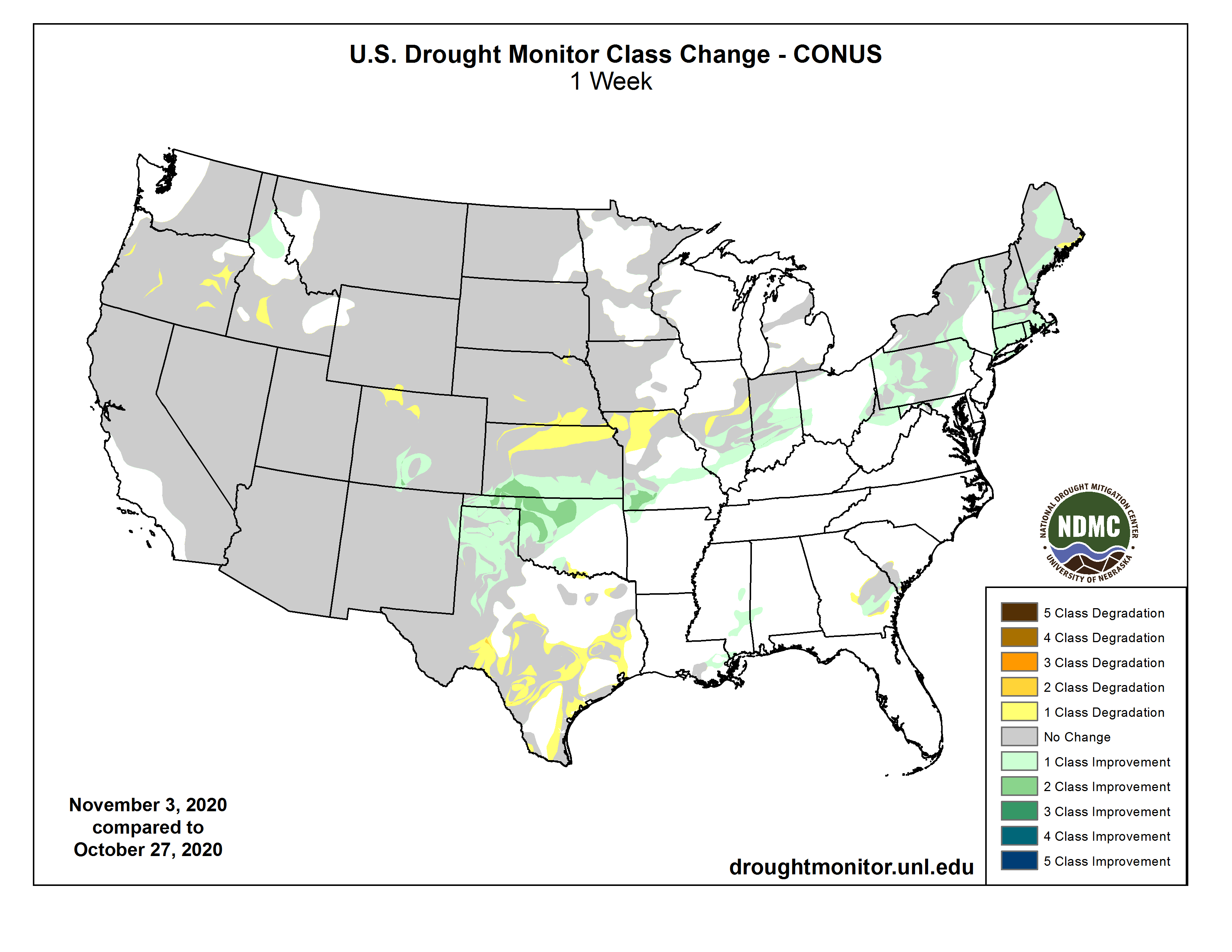
This Week’s Drought Summary
Hurricane Zeta made landfall near Cocodrie in southeastern Louisiana during the late afternoon on Wednesday, October 28, as a Category 2 hurricane with sustained winds estimate at 110 mph. With a fast northeastern track that took it off the mid-Atlantic Coast in about 24 hours, the rapid pace limited rainfall totals along its track to between 2 and 4 inches, with locally heavier amounts in southern Mississippi and Alabama of up to 8 inches. Unfortunately, the fast pace delayed the weakening of Zeta’s winds, and widespread wind damage and power outages occurred along Zeta’s path, even into the mid-Atlantic. In addition as the period started, an upper-air low over the southern Rockies slowly tracked eastward, becoming infused with tropical moisture from Zeta and the Gulf of Mexico. It dumped 1.5 to 3.5 inches of precipitation, locally to 5 inches, from the western Oklahoma and northern Texas Panhandles eastward across northern Oklahoma and southern Kansas, southern Missouri and northern Arkansas, and into the Ohio and Tennessee Valleys. Although the precipitation was very beneficial to the winter wheat crop and pastures, some of the precipitation fell in the form of snow and freezing rain in western Texas, Oklahoma, and Kansas, causing damage. Once the upper-air low and Zeta cleared the East Coast, much drier and colder air rushed into the Northeast and Southeast, with light snow accumulating across parts of western New England and upstate New York. Elsewhere, little or no precipitation occurred in the Far West, Southwest, Rockies, southern and northern Plains, and upper Midwest. Subnormal weekly temperatures enveloped the Midwest, southern and central Plains, and Northeast, while the West, Rockies, and Southeast experienced near to above-normal readings. Welcome showers fell across most of Puerto Rico while drought expanded across portions of Hawaii’s Big Island…
With much of the region cold and dry this week, status-quo was the norm for most states that either received precipitation 2 weeks ago (Wyoming, Montana, the Dakotas), or deteriorations were made (North Dakota). Unfortunately, southern Nebraska and northern Kansas missed out on precipitation during late October, thus some degradations were made there. With short-term (out to 90-days) SPIs much drier than D1, and 90-day precipitation less than half of normal – producing 4-6 inch deficits – D1 was extended across northern Kansas and into southeastern Nebraska. D2 was slightly expanded into northwestern Kansas and southwestern and northeastern Nebraska. Wetter conditions at 4-months limited the deteriorations made this week, along with a dry climatology during October and November. In contrast, the upper-air low that trekked from the southern Rockies to the mid-Atlantic and became infused with Gulf moisture courtesy of Hurricane Zeta dumped welcome and heavy precipitation (1-4 inches) across southern Kansas, effectively allowing a 1-category improvement across the southern third of the state. The middle third of Kansas remained unchanged…
Dry weather prevailed across the entire West, with only light precipitation (less than 2 inches) reported in western Washington and the extreme northern Cascades. Temperatures gradually increased during the week, with most locations averaging at or above-normal weekly anomalies. With beneficial precipitation falling the previous week (Oct. 21-27) across the Northwest and Rockies, no deteriorations were made this week where precipitation fell in late October. However, with two consecutive weeks of no precipitation, the wet season that should be in full swing by now, and lingering long-term impacts, some slight deterioration was made in Oregon (D2 and D3 expansions) and southwestern Idaho (Elmore County to D1). In northern Colorado, D4 was expanded into northern Routt and northern Grand Counties which missed significant precipitation 2 weeks ago, with SPIs, evaporative demands, and precipitation out to 6-months at D4 levels. No changes were made in the Southwest as October and November are climatologically dry. In contrast, additional investigations to last week’s precipitation called for improvements to central Idaho (D0 removed in Clearwater Basin) and south-central Colorado (D3 and D2 reductions) from recent precipitation and overall favorable impacts…
As the week started, the upper-air low over the southern Rockies tapped Gulf moisture, bringing welcome and beneficial precipitation (1.5-5 inches) to the south-central Plains. Unfortunately, the demarcation of the haves versus have-nots was sharp, with southern Kansas, the northern half and far eastern Oklahoma, and the Panhandles of Oklahoma and Texas coming out favorably. Accordingly, the copious precipitation resulted in 1- and 2-cat improvements, particularly in northwestern Oklahoma where 3-5 inches fell, including some light amounts the previous week. Western Texas, much of it in D3-D4, did receive some light precipitation (0.25-1 inch), but could have used a lot more, and improvements were minimal. In contrast, little or no precipitation fell on the southern half of Texas for the second consecutive week, resulting in additional degradation. October is normally one of the wetter months in south-central Texas, so with many locations measuring less than 25% of normal the past 30 days, short-term deficits have rapidly accumulated. USGS 7-day average stream flows have also picked up on the dryness, with many gauges in the much below category (less than tenth percentile)…
Looking Ahead
During the next 5 days (November 5-9), a change in the upper-air pattern should bring unsettled weather (cold and wet) to the West, including moderate to heavy totals (1-3 inches) to the Cascades, Sierra Nevada, and Rockies, according to WPC’s 5-day QPF. Light rain is expected in the upper Midwest, while moisture from the remnants (or reformation) of Hurricane Eta (currently in Central America) will soak southern Florida. The rest of the contiguous U.S. should be mostly dry. Temperatures during the next five days will average above-normal for much of the Nation (from the Rockies eastward), while cooler weather envelops the Far West.
The Climate Prediction Center’s 6-10 day outlook (November 10-14) favors above-normal precipitation across Alaska, the Northwest, Midwest, and East Coast. Subnormal precipitation was limited to the northern Plains, with equal chances elsewhere. Odds for subnormal temperatures are quite likely across the West, Rockies, and High Plains, while above-normal readings are strongly favored in the eastern third of the Nation.
And just for grins here’s a gallery of early November US Drought Monitor maps for the last few years.