

Click the link to read the release from the Town of Parachute on the Glenwood Springs Post Independent website (Ray K. Erku). Here’s an excerpt:
Waters from a creek in Parachute continue to rise and threaten nearby residences, a town official said.
Town Manager Travis Elliott said Thursday [May 4, 2023] morning that the flow of Parachute Creek is currently at its highest it has been in nearly 50 years. The creek runs from the high country north of town into the Colorado River.
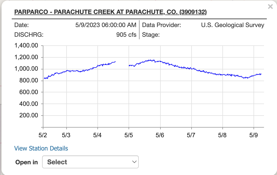
During a high runoff season in 1976, the creek reached a depth of 9.47 feet. As of 11 a.m. Thursday, a monitor showed the creek had reached a depth of 9.42 feet deep. The creek also reached a flow of 1,120 cubic feet per second, as of 3 p.m. Thursday.
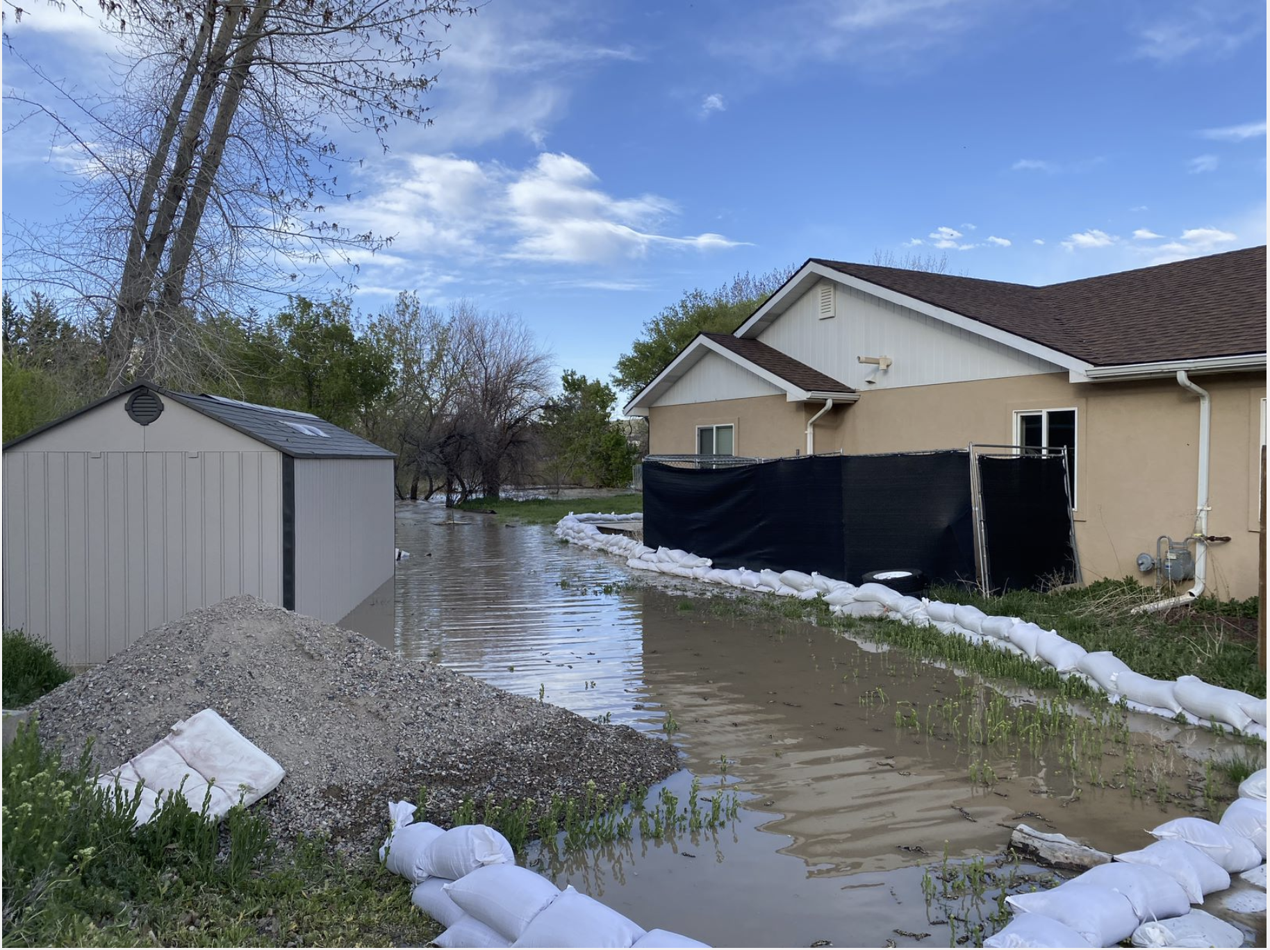
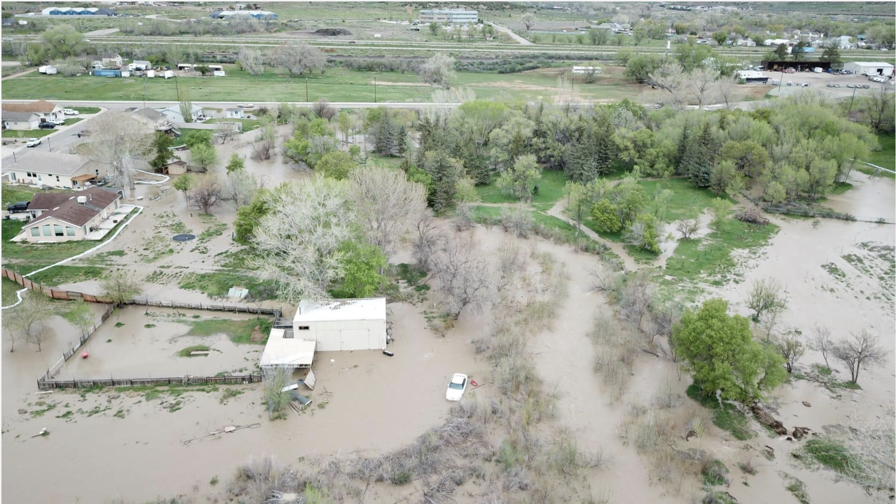
The rising water level has caused flooding in multiple spots throughout town, which is threatening up to 16 buildings and residences. This includes neighborhoods along Cardinal Way, near Grand Valley High School, Cottonwood Park and Russey Avenue on the north side of Interstate 70.
“In some places it looks like the swamplands of Louisiana,” Elliott said. “But, overall, I think we are in good shape thanks to the generosity and resiliency of our community members.”
There have so far been no indications of evacuations. Community members have spent this past week setting up sandbags and barriers in the hopes of keeping the rising water levels at bay.
“We’ve gone through about 1,000 sandbags,” Elliott said.
Structures being directly threatened by water include sheds, shops and various outbuildings, as well as homes. One residential basement is already flooded in three feet of water, Elliott said.
The city is also concerned the rising waters could reach the bottom of local bridges while the city is monitoring its sewer lift station at the wastewater treatment plant.
One Cardinal Way resident, Brandon Renck, said his backyard is currently being threatened by water.
“That’s definitely swirling around our house,” he said. “Some of the neighbors down the street have it worse than us. It’s definitely scary.”
Renck said his backyard is adjacent to Parachute Creek and the water damaged his landscaping. He also said he had a “really nice fence that got swept away.”
“We have a row of sandbags on our property,” he said. “If it gets high onto our grass, it would get to our back door.
We have friends we can stay with. Other than that, there’s not a whole lot that we can do.”
Mayor Tom Rugaard said, instead of going to practice, he brought members of his wrestling team to help put up sandbags. The Grand Valley Fire Protection District, Grace Bible Church, other high school kids and various residents have helped with mitigation efforts. The Garfield County Sheriff’s Office, its emergency manager, and the city of Rifle have made it clear they’re on standby, ready to help when necessary, the town said.
On Tuesday, the town had at least 40 volunteers helping fill sandbags, some as young as six as well as senior citizens.
“It’s been really cool, and I’m really proud of the people in our area who have come out of the woodwork to help the people in need,” Rugaard said.
“It’s really nice to be a part of a community that jumps in and helps others out.”
While the help has been nice, Rugaard did express some frustrations over the lack of data keeping for creeks and other elements.
“We have all these agencies that watch the Colorado River for us, but as far as tributaries? There’s not a lot of information out there,” he said. “There’s tools out there, but it would be nice to know how much snowpack is left and how that’s going to affect us yet.”
Elliott said there’s cooler weather in the forecast, which can hopefully help bring down the rising levels of Parachute Creek.
“We know there’s a lot more coming,” he said. “It’s all a matter of how fast it melts.”
Here’s a drone video of the flooding:
Garfield County is providing sandbags to residents in unincorporated areas who may be at risk of flooding as the local snowpack melts and rivers and streams rise. Up to 20 filled sandbags may be available on site at Garfield County Road and Bridge locations or residents can pick up 50 empty sandbags that they can fill off site.
The bags area available from 8 a.m. to 4 p.m. at the Rifle Road and Bridge campus, 0298 County Road 333A, and by appointment only from 7 a.m. to 3 p.m. at the Glenwood Springs facility, 7300 Highway 82. Residents of unincorporated western Garfield County can also pick up unfilled sandbags at the De Beque Fire Protection District station, 4580 U.S. Highway 6. Those bags can be filled at the Cowboy Chapel at the corner of county roads 204 and 211, just north of De Beque.
Residents living within cities or towns should contact those municipalities directly for assistance with issues related to potential flooding. Contact Garfield County Road and Bridge at (970) 625-8601 for more information or to schedule an appointment to pick up sandbags at the Glenwood Springs location.
Visit garfield-county.com for local updates on flood conditions and possible impacts and sign up for Garfield County Emergency Communications Authority (GarCo911) alerts at garco911.com/.