Aerial image of entrenched meanders of the San Juan River within Goosenecks State Park. Located in San Juan County, southeastern Utah (U.S.). Credits Constructed from county topographic map DRG mosaic for San Juan County from USDA/NRCS – National Cartography & Geospatial Center using Global Mapper 12.0 and Adobe Illustrator. Latitude 33° 31′ 49.52″ N., Longitude 111° 37′ 48.02″ W. USDA/FSA, Public domain, via Wikimedia Commons
From email from Reclamation Western Colorado Area Office:
The Bureau of Reclamation has reduced the release from 4,600 cfs to 4,300 cfs this morning at 8:30 AM to allow local emergency management entities to assess and respond to conditions on the ground downstream of Navajo Dam. Reclamation will continue working closely with emergency management during this managed release and a notice will be sent out prior to the next release change.
Areas in the immediate vicinity of the river channel may be unstable and dangerous. River crossing may change and be impassable as flows increase. Please use extra caution near the river channel and protect or remove any valuable property in these areas.
Please stay tuned as a notice with an updated schedule will be sent out daily during the release. Notices will also be posted to our website along with the latest release schedule. http://www.usbr.gov/uc/wcao/water/rsvrs/notice/nav_rel.html
For more information, please see the following resources below:
Bureau of Reclamation:
• Susan Behery, Hydrologic Engineer, Reclamation WCAO (sbehery@usbr.gov or 970-385-6560).
A short post, to catch up on Colorado River current events. As you probably know, if you haven’t been living in a media-free cave, the three Colorado River states below the canyon region have proposed another alternative plan for saving the River’s reservoir system.
Their proposal, for answering the Interior Department’s call for cuts of at least two million acre-feet (maf) of water annually, is to cut three maf total over the next three years – and they want 1.2 billion dollars from the federal government to execute their plan.
Their plan is basically to pay farmers to voluntarily fallow some of their land. They say they will do half of the cuts – 1.5 maf – in 2024, the remainder over the following two years. Beyond that, there are no firm details at this writing as to how much of the cuts will come from each state, how much they will be paying farmers, et cetera.
Basically, what it looks like on the surface of it, is that the Lower Basin states have countered the Bureau’s four existing scenarios – two from the Bureau of Reclamation, one from California, and one from the other six River states – with an offer to do half of the minimumcuts the Bureau said we need, and they want a billion dollars to do it. What a deal.
If their plan to pay farmers to leave the water in the system sounds familiar, that may be because the four Upper Basin States tried a similar plan this year, the System Conservation Pilot Program, with a fund of $125 million from the ill-named Inflation Reduction Act. Upper Basin farmers did not rush to take up the offer. Only 88 submitted applications to participate, of which around 20 percent were rejected; the remainder will, if things work out as projected, save 39,000 acre-feet at a cost of $16 million. That is a very small piece of two million acre-feet.
The High Line Canal is an irrigation ditch built in the 1880s. Denver Water still uses the canal to deliver irrigation water to customers when conditions allow. Photo credit: Denver Water.
It has been said that farming – especially irrigated farming – is a calling, not an occupation. I have heard farmers and ranchers talk about ‘a working contract with the land,’ and in the Upper Basin at least there seems to be something almost offensive to many farmers about the idea of being paid to not farm some of their land. Ranchers in the Upper Gunnison say it takes up to five years to bring a hayfield back to full productivity after a year of no water (or very little). We’ll see, I guess, if Lower River farmers have the same basic feelings….
A further reason for the low turnout for the Upper Basin’s System Conservation Program might be that Upper Basin farmers believe – correctly enough – that the two million acre-foot ‘structural deficit’ is not their problem and they should not be expected to exercise themselves to help deal with it. A logical enough response when working with a Compact that, as one of the Compact commissioners said, is ‘almost making two rivers out of one in the Colorado River.’ The ‘Glen Canyon Wall’ near Lee Ferry eliminated that ‘almost.’ There has been no indication from the Lower River states that they would be merciful to the Upper River states, should the drought (not ‘caused’ by the Upper States) drive the available flow past Lee Ferry below the Compact allotment; so why should the Upper River states feel empathy for the Lower Basin states?
It was reported in the national media, by the way, that the Upper Basin states have ‘accepted’ the Lower Basin’s proposal. They have not, yet. The four Upper states merely said it was okay for the plan to be evaluated along with the other four proposals in the Bureau’s ‘Supplemental Environmental Impact Study.’
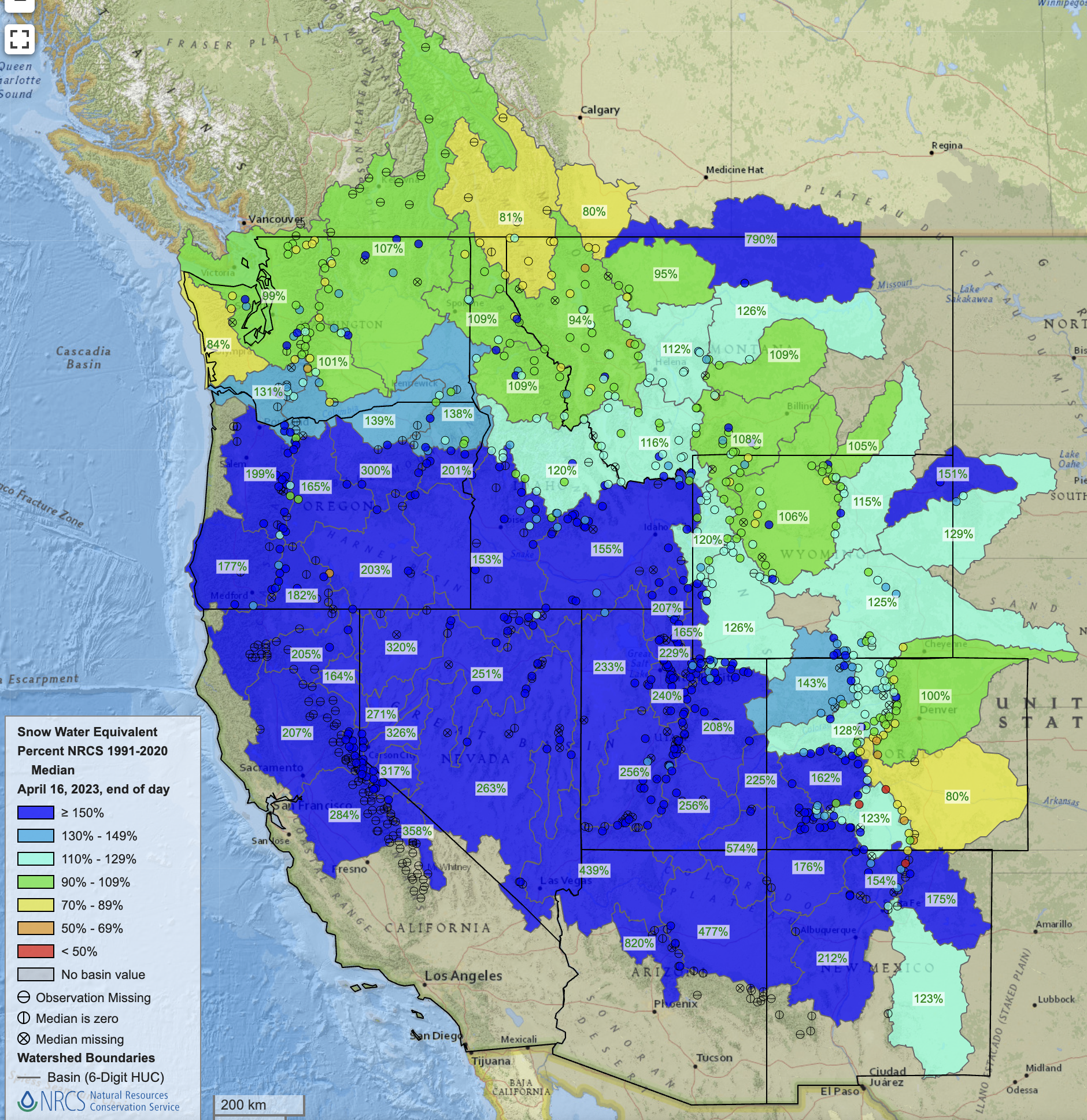
West snowpack basin-filled map April 16, 2023 via the NRCS.
All that noted – the Lower Basin proposal will probably be accepted for a variety of reasons. One reason is that the runoff from a good snowpack is probably going to give temporary relief on the reservoir levels; we should end the water year with both Powell and Mead Reservoirs higher than they were at the beginning of the year (water year is October to October), and that provides a little breathing room. (Keep in mind, though, that the Bureau first issued its major warning and challenge in 2022, saying that big reductions had to happen beginning in 2023. Now, nothing big will happen until 2024. Pray for snow next winter too.)
Another reason the proposal will probably be accepted is because if any of the other four proposals were to be chosen by the Bureau, one or more of the Lower Basin states would sue the government. There might be an element of desperation to both the gambit of promising to try to deliver only half of the requested cuts, and to the threat to sue if asked to deliver the whole 2 maf/year. The Bureau wants the Lower River region that serves a tenth of the national population and produces most of our winter fresh green stuff to cut their water use by almost one third – and do it next year. That’s a big request, maybe an unreasonable request.
Never mind that, had the Bureau and the seven Basin states been living in the real world, they would have taken care of the ‘structural deficit’ decades ago, with a gradual drop in Lower River use, reflecting the growth of use in the Upper River states that was eating into the so-called ‘surplus’ that the Lower Basin had grown to depend on take care of its system losses, and also its half of the allotment to Mexico.
And a final reason why their proposal will probably be accepted? 2024 is a presidential election year, with the current administration on the line, and both Arizona and Nevada are important swing states. ‘Nuff said.
It will come down to whether, next year, the three Lower River states can find enough farmers and cities willing to voluntarily give up a million and a half acre-feet of water next year. Tucson and the Gila River Indians have already made commitments. Meanwhile – pray for snow next winter.
What effect will fallowing thousands of acres of fields have? Will it lead to another Dust Bowl?
Is the electricity from the dams used to deliver water (e.g. to power the pumps for the Central Arizona Project)?
And what purpose do the two reservoirs (Powell and Mead) serve in the system and how does that factor into the bargaining between the states?
I’ll just explore the first two today, since that’s all I have room for.
My short answer for question #1 is: I don’t know. One of the problems with the deal is that very few details have been made public, so it’s difficult to understand what ramifications it might have.
But we do know that the Lower Basin states plan to come up with 3 million acre-feet of water over three years — or about 1 million acre-feet per year — by paying water users to slash consumption. Federal funds will be used to reimburse folks for 2.3 million acre-feet of those cuts, while state, local, or other funds will be used for the remaining 700,000 acre-feet. It’s fair to guess that a bulk of these savings will be realized by paying farmers not to irrigate their crops, since agriculture is by far the biggest user of Colorado River water, and that makes more logistical sense than paying folks not to water their lawn. So that’s a good place to start.
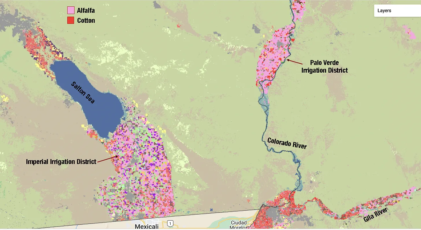
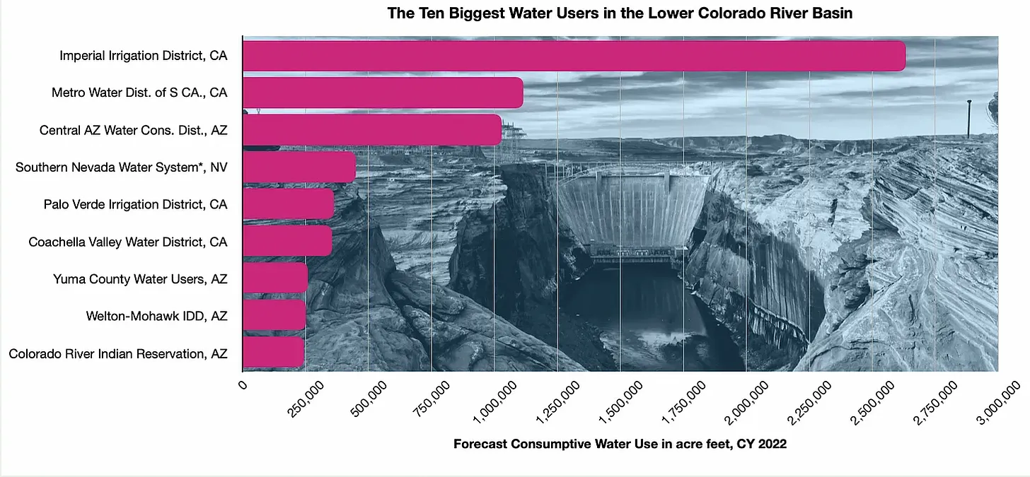
I’ve also read reports saying the Imperial Irrigation District, the largest single water user in the Basin, plans to give up 250,000 acre-feet per year (which will be included in the above amounts).
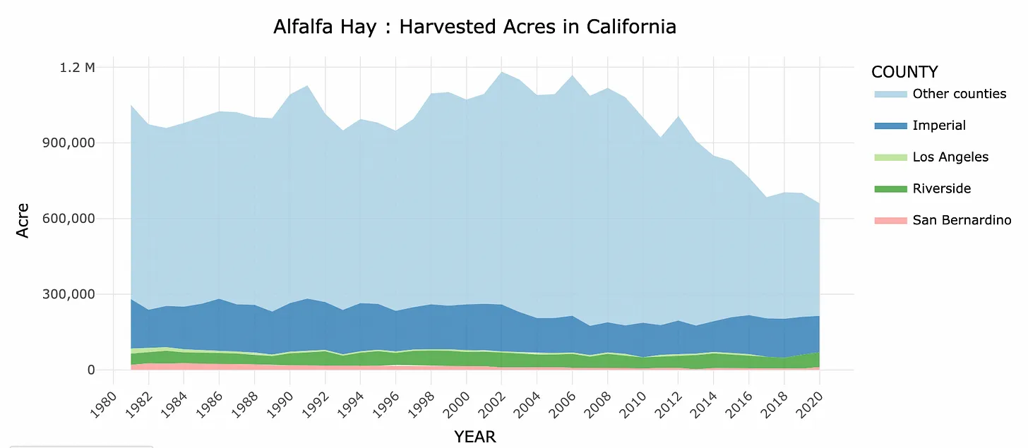
One of the most abundant crops in the Colorado River Basin is hay, primarily alfalfa. It is also one of the thirstiest crops. Growing one acre of alfalfa guzzles around four acre-feet of water per year, depending on location, climate and length of growing season. In Colorado’s high-elevation, cool San Luis Valley, alfalfa consumes about two acre-feet per year; in California’s sea-level Imperial Valley — one of the hottest places in the nation — the crop can require more than six acre-feet of water per year.
Since the fallowing is likely to occur in hot, dry southern Arizona and California, we’ll go with the six-acre-feet-annually figure. That would mean that in order to reach the target water cuts, irrigation would have to be stopped on a total of 167,000 acres of alfalfa fields, or roughly three-fourths the size of the Salton Sea. Targeting less thirsty crops would require fallowing a larger amount of acreage. About 42,000 acres of that would be in the Imperial Irrigation District, assuming the fields they fallowed were alfalfa. For some more context: An MIT study found you’d need 90,000 acres of solar panels to replace the Diablo Canyon nuclear power plant’s generation.
So, yeah, it’s a lot of acreage, and ceasing irrigation on that land could very well turn it into desiccated weed patches. Maybe it won’t be Dust Bowl kinda stuff for now, but it could get ugly, especially in a dry summer. In the San Joaquin Valley in California, for example, a groundwater management program (no relation to the Colorado River crisis) is forcing farmers to fallow fields, which is leading to serious dust and air quality problems.
The Imperial Valley is next to the Salton Sea, where the air — and residents’ lungs — is already thick with dust. Fallowing all of the Valley’s alfalfa fields surely would further exacerbate the problem. At this point it’s not clear where fields will be fallowed, only that some will be in California and some in Arizona (Nevada uses almost all of its Colorado River water for municipal uses in Las Vegas and surrounding communities).
Media outlets have reported that the states plan to pay those farmers $1.2 billion from the federal Inflation Reduction Act. That would put a $521 price tag on each acre-foot of water not going onto a field. Using the 6 acre-foot per acre of alfalfa figure, that would mean an Imperial Valley farmer could get more than $3,000 per acre to not grow anything.
That’s not a bad deal. According to the UC Davis cropland data layer site, Imperial Valley farmers harvested 144,000 acres of alfalfa hay in 2020. They produced 1.14 million tons of alfalfa hay, valued at $200.44 million — or an average of $1,391 per acre. In other words, the farmers could bring in twice the revenue for not farming than for farming their acreage.
But it would also reduce the supply of alfalfa, causing prices to increase, which would likely ripple through the beef and dairy industries, where most of that alfalfa goes. That, in turn, could eventually make its way down to the ice cream and cheese aisles at your local grocery store.
2. The second point Ann made was that moving water from the Colorado River to fields and cities takes a lot of energy, including the power generated by the dams on the Colorado River. So when irrigators reduce their Colorado River water use it’s leaving more water in the river, which can generate more energy when run through the dams’ turbines, which can move more water to the fields … Woah, I am getting dizzy here.
It’s a classic example of the water-energy nexus or, in this case, the water-energy-water nexus, one of my favorite topics.
Glen Canyon, Hoover, and several other dams on the Colorado River system are hydroelectric, meaning as water runs through them, it can be routed through turbines, generating power. As reservoir levels drop, so does the power generation capacity of the dam. And if the reservoir levels fall below the openings to the penstocks — or tubes leading to the turbines — then power production ceases altogether.
This freaks folks out in these climate changed times for good reason: The warmer it is, the more power we need to run air conditioners, and the more water irrigators need to put on their crops, meaning more power is needed to move that water. But the warmer it is, the lower the reservoirs and the less power we have. Ack!
The Central Arizona Project is one of the biggest water-moving projects on the Colorado River. Its pumps pull water from the Colorado River at Lake Havasu and move it 336 miles across the Arizona desert (in an uncovered canal, allowing massive amounts of water to evaporate), with a total elevation gain of more than 2,900 feet. That takes a buttload of energy. In fact, it takes so much power that the coal-fired Navajo Generating Station was built in large part to run the CAP pumps.
2 million megawatthours: Annual power consumption of the Central Arizona Project pumps.
2 million megawatthours: Annual power consumption of the five pumping stations on the Colorado River Aqueduct, which delivers water to Los Angeles and surrounding areas.
2.5 million megawatthours: Annual power output of Glen Canyon Dam in 2022
3.9 million megawatthours: Annual power output of Glen Canyon Dam in 2008
1.5 million megawatthours: Annual power output of Hoover Dam in 2022
259 million megawatthours: California’s annual power consumption.
The Navajo Generating Station was retired in December 2019, forcing the CAP to find power from elsewhere. Now the project gets 70% to 80% of its power from market forward and short-term purchases; 12% to 15% from the Salt River Project electric utility; 6% from Hoover dam; and 4% from a solar installation. About half the power for the Colorado River Aqueduct pumps comes from Hoover and Parker dams, with the rest coming from a mix of market purchases and hydroelectric generation within the Aqueduct system.
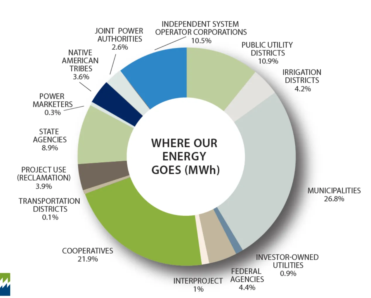
And then there’s the question of how much of the dams’ electricity goes toward moving water around. The Western Area Power Administration markets the electricity from Glen Canyon Dam and 56 other hydropower dams. Here’s a breakdown of who purchases that power:
While only 4% goes to irrigation districts, you can assume that portions of many of the other categories go to moving water or treating it. So if the hydropower capacity of the dams were to shrink or vanish altogether, all of these customers — including the water folks — would have to find new sources of electricity.
“This Supreme Court ruling weakens our federal standards for clean water, threatening our ability to protect ecosystems and landscapes needed for birds and communities across the country,” said Julie Hill-Gabriel, Audubon’s Vice President for Water Conservation.
“Federal experts will no longer be able to require certain development permits in America’s decimated wetlands. This decision undermines Clean Water Act protections for many types of waterways that birds and people need, all while birds are telling us that more action is needed to protect their future.”
In today’s [May 25, 2023] ruling, the United States Supreme Court curtailed the ability of the Environmental Protection Agency (EPA) and the United States Army Corps of Engineers to regulate “waters of the United States”. While the Clean Water Act includes regulatory definitions for most large bodies of water and rivers, smaller waterways which may be seasonal or disconnected are not as clearly defined. Today’s ruling limits the ability of the agencies to permit activities on many of these smaller waterways and means that unregulated development can occur in many of these areas.
With the loss of 3 billion birds in the past 50 years—in part due to dwindling wetlands and significant development of natural spaces—and Audubon science showing that two-thirds of North American bird species are at risk of extinction from climate change, action is needed to protect the water bodies and habitat that birds need to survive. Waters throughout the United States like seasonal streams and isolated wetlands serve as essential habitat for birds and other wildlife. These water bodies provide crucial sources of drinking water, food, and nutrition for birds. Birds also uses lakes, streams, and wetlands for breeding and nesting, as well as for rest stops during long migratory journeys.
Wetlands and seasonal streams provide more than just critical bird habitat—they also provide us with nature’s filters to clean our drinking water and protect us from storms, floods, and other climatic stressors. Too many low-income communities, Tribal communities, and communities of color do not have consistent access to safe, affordable drinking water and strong protections under the Clean Water Act are needed to support these communities.
“More than fifty years ago, Congress came together in a bipartisan manner to pass the Clean Water Act,” said Hill-Gabriel. “We all need clean water to survive and thrive and this ruling means that there are now fewer tools in the toolbox for our federal agencies to protect vital habitats and waterways for birds and people.”
Audubon will continue working with state and local decision-makers to strengthen protections for waterways that birds need.