El Niño is officially here, and while it’s still weak right now, federal forecasters expect this global disrupter of worldwide weather patterns to gradually strengthen.
That may sound ominous, but El Niño – Spanish for “the little boy” – is not malevolent, or even automatically bad.
Here’s what forecasters expect, and what it means for the U.S.
What is El Niño?
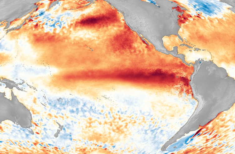
El Niño is a climate pattern that starts with warm water building up in the tropical Pacific west of South America. This happens every three to seven years or so. It might last a few months or a couple of years.
Normally, the trade winds push warm water away from the coast there, allowing cooler water to surface. But when the trade winds weaken, water near the equator can heat up, and that can have all kinds of effects through what are known as teleconnections. The ocean is so vast – covering approximately one-third of the planet, or about 15 times the size of the U.S. – that those sloshings of warm water have knock-on effects around the globe. https://www.youtube.com/embed/_Tuou_QcgxI?wmode=transparent&start=0 The National Oceanic and Atmospheric Administration explains teleconnections and the impact of El Niño.
That warming at the equator during El Niño leads to the warming of the stratosphere, starting about 6.2 miles (10 kilometers) above the surface. Scientists are still studying how exactly this teleconnection occurs.
At the same time, the lower tropical stratosphere cools.
That combination can shift the upper-level winds known as the jet stream, which blow from west to east. Altering the jet stream can affect all kinds of weather variables, from temperatures to storms and winds that can tear hurricanes apart.
Basically, what happens in the Pacific doesn’t stay in the Pacific.
So, what does all that mean for you and me?
With apologies to Charles Dickens, El Niño tends to create a tale of two regions: the best of times for some, and the worst of times for others.
On average, El Niño years are warmer globally than La Niña years – El Niño’s opposite. Globally, a strong El Niño can boost temperatures by about 0.7 degrees Fahrenheit (0.4 Celsius). But in North America, there is a lot of local variation.
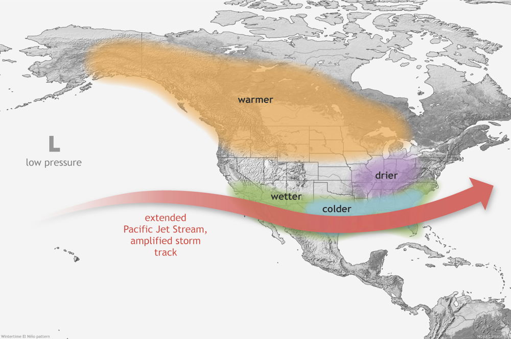
El Niño years tend to be warmer across the northern part of the U.S. and in Canada, and the Pacific Northwest and Ohio Valley are often drier than usual in the winter and fall. The Southwest, on the other hand, tends to be cooler and wetter than average.
El Niño typically shifts the jet stream farther south, so it blows pretty much due west to east over the southern U.S. That shift tends to block moisture from the Gulf of Mexico, reducing the fuel for thunderstorms in the Southeast. La Niña, conversely, is associated with a more wavy and northward-shifted jet stream, which can enhance severe weather activity in the South and Southeast.
Over the Atlantic, El Niño tends to increase wind shear – the change in wind speed with height in the atmosphere – which can tear apart hurricanes. But El Niño has the opposite effect in the eastern Pacific, where it can mean more storms. The ocean heat can also raise the risk of marine heat waves that can devastate corals and ecosystems fish rely on.
In the middle of the U.S., El Niño is generally associated with warmer and drier conditions that can mildly increase the chances of a bountiful corn crop.
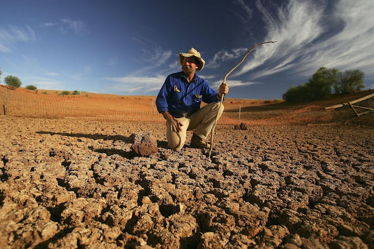
Australia endured its worst drought in decades in 2005 with the combined effect of increasing temperatures and an El Niño. Ian Waldie/Getty Images
Of course, just because this is normally what happens doesn’t mean it happens every time. Witness California’s record rainfalls from multiple atmospheric rivers at the end of the last La Niña, which normally would mean dry conditions.
Every weather event is somewhat different, so the influence of El Niño is a matter of probability, not certainty. How El Niño and La Niña will be influenced over time by climate change isn’t yet clear.
The forecasts don’t all agree
Is 2023 going to be a record-breaking year? That’s the multibillion-dollar question.
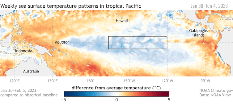
The National Weather Service declares the onset of El Niño when water temperatures are at least 0.9 F (0.5 C) above normal for a three-month period in what’s known as the Niño3.4 region. That’s a large imaginary rectangle south of Hawaii along the equator.
Watching El Niño develop in the tropical Pacific, January to June 2023. The box shows the Niño3.4 region. NOAA Climate.gov
For a strong El Niño, the Niño3.4 region needs to warm by 2.7 F (1.5 C) for three months. It’s not clear as of right now whether this El Niño will meet that threshold this year.
The National Oceanic and Atmospheric Administration’s first El Niño advisory of the year, released on June 8, sees an 84% chance of El Niño being greater than moderate by winter and a 56% chance that it will be strong.
“Dynamical” models, similar to the models used for typical weather forecasts, have projected a very strong El Niño, whereas “static” or statistical models are far less optimistic. Personally, I’m a statistical modeler, and my own model doesn’t suggest a strong El Niño in 2023. Rather, my model – like other static models – predicts that 2023 will fizzle out, and after a couple of quiet, or neutral, years, we will see a strong El Niño in 2026. I did get the recent unusual “triple dip” La Niña right, but I’m willing to be proved wrong by observations, as any good scientist should be.
But no computer model of any flavor has had experience with the globally super-high ocean temperatures that are occurring right now. The Atlantic is unusually warm, and that could offset some of the usual forces that come with El Niño.
Leyden street and turf. Photo credit: Allen Best/Big Pivots
Click the link to read the article on the Big Pivots website (Allen Best):
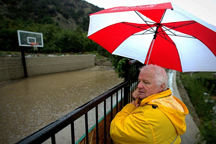
Like hard rains amid the Dust Bowl, Colorado has lots of water almost everywhere now amid long-term drought. That’s exactly the time to talk about what do as hotter and drier inevitably return.
The Colorado Water Conservation Board chose an awkward time to conduct a drought summit, launching the two-day event on the last day of May at History Colorado in downtown Denver.
It was the fourth wettest month in Denver since 1876, before Colorado was a state, and June got off to a soggy start, too. This followed one of the snowiest winters in decades in some parts of Colorado. The only part of Colorado still in drought is in the state’s southeastern corner.
The somewhat awkward timing was noted by Anne Castle, of the Getches-Wilkinson Center for Natural Resources, Energy and Environment at the University of Colorado Law School. “It’s perfect time to hold a drought summit,” she said with intended irony.
Like others, though, she doesn’t expect this wetness to last. Most of Colorado, including cities and farms east of the Continental Divide, depends upon water from the Colorado River and its tributaries, and it should be news to exactly no one that those who depend upon the largesse of that river have a serious re-reckoning underway. Too slow in some places, according to at several speakers at the conference.
Unlike last year, though, the heat is off. That is good, said Castle. “We can make better decisions when we’re not right in the midst of a crisis, as long as we recognize that one winter does not solve our long-term problems.”
That problem is not necessarily drought, although Colorado and Southwestern states clearly have seen less precipitation in the last 20-plus years. Droughts come and go, and this one in the Colorado River Basin is the worst in at least 1,200 years. Something more is happening here, what scientists call aridification. In aridification, it can snow just as much, but warmer temperatures draw more of the precipitation into the atmosphere. At least one study found that up to 50% of the declined flows in the Colorado River could be attributed to the warming now underway.
Aridification doesn’t roll off the tongue quite so easily as drought, noted Russ Sands, section chief for water supply planning at the CWCB.
Make no mistake, though. Climate change, a subject approached gingerly 20 years ago by state water officials, has become part of the conversation. Consider Greeley.
The once-smallish city located at the confluence of the Poudre and South Platte Rivers has grown to a population of more than 110,000 residents. That is almost certainly just the beginning.
Sean Chambers, director of water and utility services for Greeley, said the city expects to need to expand its water portfolio, currently at 35,000 acre-feet, to 80,000 acre-feet by 2080. “That does not get Greeley to build-out; it’s only half-way there,” he said.
The city gets about 40% of its water from the Colorado River Basin.
Chambers said Greeley is starting to integrate the impacts of climate change into its planning, among them pressures on reservoirs, different times of runoff, and more watershed disruptions.
“All of these risks and challenges on the water system driven by climate change come on top of managing for growth and uncertainties around supply,” he said.
As for its planning, Greeley hopes to keep ahead of hard pressures. Last year, the city gained access to an aquifer to the north of the city that it plans to manage in conjunctive fashion. It can be drawn upon when needed but also used as a storage vessel.
“It’s really difficult to innovate when your back is against the wall,” he said during a panel discussion under a heading of “storage, conservation and innovations.”
Peter Mayer, a Boulder-based consultant who has worked for 30-plus years in water demand management, said conservation has worked very well in Colorado, especially in urban sectors. “That is my specialty. We started in the late 1980s and 1990s and have seen a gradual decline in per-capita use across the state.”
Mayer argued that this has allowed Colorado’s population to grow in a way that has been much less expensive “Because conserved water is much, much cheaper generally than (developing) new supply.”
Greg Fisher, who supervises conservation efforts for Denver Water, talked about the major water reductions in its service territory since 2000, which has allowed Denver to better keep water in its reservoirs. “Conservation really works,” he said.
But there can be tensions within water agencies between programs to reduce water use and the revenue needed to pay for the infrastructure that has been installed, as described by representatives for both Colorado Springs and Durango.
“Your leaders say (conservation) is first, but in the process of setting rates, you tend to find out it’s second or third,” said Jarrod Biggs, from the City of Durango.
“Every councilor wants to make sure that they are saving the last drop and doing what is right for the community and regional partners. When talk gets to dollars and cents, conservation ends up being somewhat important, but it does kind of fall down that list, particularly if you have a very noisy political constituency.”
Castle, from the University of Colorado, who had a law practice for much of her career, pointed out the need for getting land use right, to produce urban landscapes that are less water-intensive. “It’s really the initial configuration of development that is the primary factor that influences future water demand,” she said. We have land-use plans, master plans, comprehensive plans, subdivision improvement agreements. That is where you can deal with and incentivize water conservation and incorporate that into any new development plans.”
Municipal use represents only 7% of total water consumption in Colorado, said Mayer, compared to 91% for agriculture. “What is the agriculture sector doing?” he asked. He suggested the answers can be found with better measuring.
Taylor Hawes, who directs the Colorado River program for The Nature Conservancy with 26 years of experience, talked about the need to pick up the pace.
“We have lost 20% of the Colorado River supply since 2002,” she said. The pace of change must accelerate to correspond with the need. “The longer we wait, the harder it gets.”
Allen Best is a Colorado-based journalist who publishes an e-magazine called Big Pivots. Reach him at allen.best@comcast.net or 720.415.9308.
Updated Colorado River 4-Panel plot thru Water Year 2022 showing reservoirs, flows, temperatures and precipitation. All trends are in the wrong direction. Since original 2017 plot, conditions have deteriorated significantly. Brad Udall via Twitter: https://twitter.com/bradudall/status/1593316262041436160
This image, acquired on 7 June 2023 by a Copernicus Sentinel-3 satellite, shows plumes from the Canadian fires reaching the American East Coast. In a region-spanning event, New York City found itself shrouded in thick smoke while Philadelphia and Washington DC declared a ‘code red’ emergency. By Contains modified Copernicus Sentinel data, Attribution, https://commons.wikimedia.org/w/index.php?curid=132854025
Hundreds of wildfires have been burning across Canada in what has been called an “unprecedented” start to the nation’s fire season.
Huge clouds of smoke from the blaze have blown thousands of kilometres down to the eastern US, shrouding cities such as New York and Washington DC in an orange haze and causing levels of toxic air pollution to reach record levels.
Scientists have been quick to make the link with climate change. The hot and dry conditions resulting from rising global temperatures are known to make wildfires more extreme.
Many US commentators said the fires should act as a “wake-up call” for climate action.
Meanwhile, the nation’s influential right-leaning media channels were quick to downplay the severity of the toxic smoke filling US streets.
In this article, Carbon Brief examines the role of climate change in the Canadian wildfires and how the media has responded.
What is happening with the wildfires in Canada?
In late April, forest fires began in British Columbia and Alberta, expanding to cover nine of Canada’s 13 provinces and territories. While wildfires are fairly common in the country’s western provinces, fires have opened new fronts, spreading to the eastern provinces of Nova Scotia, Quebec and Ontario, according to ABC News.
Quebec has been particularly affected, with multiple being started by lightning strikes, ABC continues. As of Tuesday 6 June, there were around 160 forest fires, which displaced some 10,000 people in the province alone, it added.
“The distribution of fires from coast to coast this year is unusual. At this time of the year, fires usually occur only on one side of the country at a time, most often that being in the west,” Michael Norton, an official with Canada’s Natural Resources ministry told Reuters.
The fires are taking place after the provinces of Alberta, Nova Scotia and Quebec experienced record heat this year, according to the Washington Post. Edmonton in Alberta, for example, saw average temperatures 6C above normal in May, hitting 17.2C, according to CBC.
Canada’s Atlantic region has also been experiencing droughts since February, with, for example, the town of Sydney, Nova Scotia, receiving only 15% of normal moisture in April, the paper says. Parts of the Atlantic region, including Nova Scotia, New Brunswick, Prince Edward Island and Newfoundland, recorded their driest April on record, it adds.
As such, by the end of April, 49% of the Atlantic Region was classified as “abnormally dry or in moderate drought”, including 77% of the region’s agricultural landscape, according to the Canadian government.
Such conditions made wildfires more likely, according to the Washington Post, although it also noted that a long-running forest management practice of fire suppression in many provinces has caused combustible vegetation that fuels fires to build up and dry out on the forest floor, playing a role in the severity.
55 million+ people across the US under air quality alerts. 9 million acres charred by wildfires in Canada this year — 15x normal. 400+ fires still burning across Canada.
Forests cover about a third of the total land area or 3.62m km2 of Canada. As of Thursday, around 2,300 wildfires had burned roughly 42,897 km2, according to Reuters. The newswire says this is more than 15 times the 10-year average for this time of year.
More than half of the 437 active fires across Canada – some 248 – were out of control as of Thursday morning, according to the Canadian Interagency Forest Fire Center (CIFFC). With the hottest and driest period of the year still to come, the country is on track for its “worst ever” wildfire season, according to Reuters.
Across Canada, more than 20,000 people have been evacuated as firefighters continue to tackle the blazes, according to the Associated Press. To support this, firefighters from the US, South African, Australia, New Zealand, France, Portugal and Spain have been deployed in the country, Reuters reports.
200+ South African firefighters landed in Edmonton, Canada to assist in the fight against the raging wildfire. 🇿🇦🇨🇦pic.twitter.com/flXKqlvYxG
A day after he spoke to Canadian prime minister Justin Trudeau, US president Joe Biden said in a statement on Thursday:
“Since May, more than 600 US firefighters, support personnel and firefighting assets have been deployed, working alongside Canadian firefighters to tackle what is likely to be the worst fire season in Canadian history and one that has huge impacts here in the US.”
Earlier this week, the Canadian government outlined a number of measures it was taking in response to the wildfires, including approving requests for federal assistance from the provinces of Alberta and Nova Scotia, partnering with provincial and territorial governments, and launching a “Wildfire Resilient Futures Initiative” with a proposed investment of $284m.
In a statement released alongside the announcements, Steven Guilbeault, minister of environment and climate change, made a clear link between the threat of wildfires and global warming. He said:
“We are already seeing one of the worst wildfire seasons on record and we must prepare for a long summer. The government of Canada is stepping up to the request for assistance from Quebec and will immediately begin mobilising Canadian Armed Forces, firefighting resources and assistance with planning to support the wildfire response in the province.
“The threat of increased fires due to climate change is one of the many reasons our government is developing a robust national adaptation strategy with all levels of government and Indigenous groups, so we can be sure our communities are well prepared for the impacts of climate change.”
What are the wider effects across North America?
Haze blanketed much of the eastern US this week as prevailing winds carried the smoke southwards from Canada.
At least 100 million Americans – nearly one-third of the US population – were under air-quality alerts on Wednesday, with the smoke spreading as far west as Chicago and as far south as Atlanta, according to USA Today.
The north-east, including major population centres such as New York City, Philadelphia and Washington DC, bore the brunt of the haze. Reuters reported that New York City temporarily had the world’s worst air quality of any major city on Wednesday afternoon. On Thursday, CBS News Philadelphia noted that that city now had the world’s worst air quality.
The Toronto Star wrote on Thursday that the city was “brac[ing] for what might be the worst air quality levels it has ever seen”, warning readers that Toronto’s air quality index might approach the levels seen in New York the previous day.
Check out this almost unbelievable time-lapse of wildfire smoke consuming the World Trade Center and the New York City skyline.
Those vulnerable to poor air quality, including seniors and young children, should limit time outdoors if possible.
Heatmap News wrote that air quality in the eastern US “has reached the worst level since 2005, when modern records began”. The piece noted that the air quality on the east coast “was comparable” to that regularly seen on the west coast during fire season, but added that “it is unheard of for such toxic air to afflict such a densely populated part of the country”.
The Atlantic advised: “It is, to put it lightly, an absolutely terrible time to go outside.” The piece noted that “masks are being urged as a precaution against the thick, choking plumes of smoke from Canada”.
The Federal Aviation Administration temporarily grounded or otherwise restricted flights into several east coast airports on Wednesday and Thursday, according to CNN.
Taking a look west from the top of the Washington Monument. You can make out the Lincoln Memorial and Potomac River some. But Virginia is not visible. The other picture shows what it looked like 3 days ago. #dcwx#vawxpic.twitter.com/p5rRFowDRZ
All along the east coast, sporting events – including baseball games, indoor basketball games and horse racing – were cancelled or postponed due to unsafe air quality on Wednesday and Thursday, the AssociatedPress reported.
The Washington Post reported that several New York City theatres had also cancelled performances on Wednesday. The White House postponed its pride month event, originally scheduled for Friday, to Saturday, according to Bloomberg.
Reuters wrote that “schools up and down the east coast called off outdoor activities, including sports, field trips and recesses”; New York City public schools announced on Thursday that Friday would be a remote-instruction day. Washington, DC suspended some non-essential city services, such as roadwork and rubbish collection, according to the local outlet DCist.
Axios reported that the US had dispatched more than 600 “firefighting personnel”, as well as firefighting equipment, to help battle the blazes in Canada.
US senator Bernie Sanders and New York representative Alexandria Ocasio-Cortez, both Democrats, took to Twitter to “issue stark warning[s]” about the connection between the wildfires and climate change, the Independent wrote.
Right now, 98 MILLION people on the East Coast are under air quality alerts from Canadian fires and, last night, NYC had the worst air quality in the world. Climate change makes wildfires more frequent and widespread. If we do nothing, this is our new reality. It's time to act.
Meanwhile, the New Republic criticised US representative Marc Molinaro, a Republican, for saying “this isn’t the moment to start lecturing people about the science of climate change”. The New Republic wrote:
“It’s almost comical the extent Republican politicians will go to deny reality…While nearly a third of the country is at risk of breathing in a dark haze straight out of dystopia, Republicans are still lecturing us for having the nerve to say enough is enough.”
Does climate change have a role in driving the fires?
There is a wide body of evidence to show that climate change is making wildfire conditions more likely in many parts of the world.
For example, dry conditions intensified by climate change can cause fires to spread more quickly over large areas.
Heat, malnutrition and harm from wildfire are some of the adverse impacts on health and well-being from human-caused #climatechange that will continue to intensify, according to #IPCC’s Synthesis Report.
The IPCC said with high confidence that “compound hot and dry conditions become more probable in nearly all land regions as global mean temperature increases”.
There is an increasing risk of forest fires in North America, the IPCC said, and the fire season across this region “expands dramatically”, if global warming exceeds 2C.
In the western US, climate change has made – and will continue to make – fires larger and more destructive, Carbon Brief reported in 2018.
No attribution studies have so far made a climate connection with the ongoing wildfires in Canada.
But previous studies have looked at the link between climate change and other extreme weather events. One study found that climate change made a 2020 Siberian heatwave at least 600 times more likely. This heat broke temperature records and led to wildfires.
Additionally, the IPCC said that wildland fire has been “identified as a top climate-change risk facing Canada”.
[…]
News outlets and experts have also been making the climate connection in recent days.
Mohammadreza Alizadeh, a researcher at McGill University in Montreal, told the Guardian that the Canadian fires are a “really clear sign of climate change”.
“The climate signal is very strong” given the size and severity of the fires, according to Robert Scheller, a professor of forestry at North Carolina State University, quoted by BBC News.
Here at #CCNow, we help journalists produce more informed and urgent climate stories. This week's wildfire smoke & very unhealthy air in the Northeastern US presents an opportunity for journalists to make the connection with climate change. Here are a few examples we applaud…🧵 pic.twitter.com/6PUXV1PbJr
— Covering Climate Now (@CoveringClimate) June 8, 2023
Experts have “pointed to a warmer and drier spring than normal” as the reason for heightened wildfire conditions in Canada, another BBC News piece said, adding:
“Fires across Canada have already burned more than 3.8m hectares (9.4m acres) of land – an area 12 times the 10-year average for this time of year.”
According to Al Jazeera, New York City mayor Eric Adams told a press briefing:
“While this may be the first time we’ve experienced something like this on this magnitude, let’s be clear: it is not the last. Climate change [has] accelerated these conditions.”
More extreme wildfires are clearly linked to climate change, and the relationship is strongest at high latitudes, like in Siberia, Canada, Alaska, and Northern Europe. Remember the wildfires in London last summer? Heatwave + dry veg. That’s all it takes.
— Dr. Crystal A. Kolden 🔥 (@pyrogeog) June 8, 2023
It is “unusual” for fires to occur “from coast to coast” at this time of the year, according to Michael Norton, an official with Canada’s Natural Resources ministry. He told Reuters:
“The rate of increase of area burned is also high…if this rate continues, we could hit record levels for area burned this year.”
The newswire further quoted Yan Boulanger, a researcher with Natural Resources Canada, who said that “partially because of climate change, we’re seeing trends toward increasing burned area throughout Canada”.
“Higher-than-normal” fire activity is possible across most of Canada during this year’s wildfire season due to ongoing drought and expected high temperatures, the country’s government said.
The fires “remind us that carbon pollution carries a cost on our society, as it accelerates climate change”, Steven Guilbeault, Canada’s environment and climate change minister, said on Twitter.
Extreme and prolonged hot and dry conditions in Canada are setting records and making it effortless for wildfires to rage.
Canada was at the epicenter of the most significant heat anomaly on the planet in May. pic.twitter.com/YlvtOvihwP
Elsewhere, however, a Yahoo News article said that, “while it may seem obvious to blame climate change for these extreme conditions, one expert clarifies that there’s more factors at play”.
Carbon Brief’s climate science contributor Dr Zeke Hausfather took a closer look at studies on Canada’s wildfires and climate change.
He wrote on his Substack that, while climate attribution studies are needed to assess the current fires, “it is clear that these sort of events are likely to become more common as the world warms”.
(For more details on how climate change affects wildfires, read Carbon Brief’s in-depth explainer from 2020.)
How has the media responded to the wildfires?
Media in Canada, the US and around the world covered the fires, the smoke and the eerie orange tint that settled on swathes of the eastern seaboard.
However, much of the ensuing commentary on the wildfires came from the US east coast. The location of some of the world’s most influential news organisations was blanketed in smoke, giving many journalists and news anchors first-hand experience of the event.
An editorial in the Washington Post said the fires were a sign that the US had to ramp up its preparations for climate change – for example, by assessing wildfire risks in areas previously considered too wet. It concluded:
“In some ways, the haze could be making everyone see more clearly what lies ahead.”
The idea that the wildfires should galvanise climate action was a common one. “Will nature’s smoke alarm serve as an American wakeup call?” asked Will Bunch, a columnist for the Philadelphia Inquirer. In his Washington Post column, Eugene Robinson wrote that, “once again, nature is sending us an unambiguous message”.
Concluding her account of a day spent in a smoke-choked New York, Carolyn Kormann wrote in the New Yorker: “We know the story of the climate crisis…Yet we live as though we do not, and we breathe the consequences.”
In his newsletter for the New York Times, David Wallace-Wells wrote that the fires could mark a shift in perceptions “away from the American West as the fountainhead of wildfire”.
From his home in Vermont, veteran climate activist and author Bill McKibben wrote in The Crucial Years, his Substack, that the fires brought people in the US closer to how “a huge percentage of the world’s people breathe every single day of their lives”. (He was referencing cities such as New Delhi and Beijing that have high rates of air pollution.)
Everyone who has lived in a big Chinese / Indian city during the past couple of decades, or in Pacific NW / SF Bay area / SoCal during US/Canadian wildfires is thinking:
Yes, we feel for everyone in smoke-ridden NYC!
And, we can't help but notice the diff in press attention.
Some, such as former Atlantic national correspondent James Fallows, pointed out what they viewed as a media bias towards the events on the east coast of the US.
Responding to this in his New York Times column, Paul Krugman wrote:
“That’s a minor issue compared with the importance of learning from these crises, now that enough influential people have seen with their own eyes what’s happening.”
I've met many people who say that California's 2020 orange sky day was the moment they understood what a warming world really looks like.
It was a wake up call. Some changed careers. Others got politically involved.
Meanwhile, as clouds of smoke billowed through some of the nation’s largest cities, many right-leaning US news outlets responded with a shrug. Their attitude was summarised by a Rolling Stone article titled: “Right-wing media is saying the wildfire smoke is good, actually.”
The article quoted lobbyist Steve Milloy, a “big oil mouthpiece who has long denied climate change”, who appeared on Fox News host Laura Ingraham’s show and said:
“This doesn’t kill anybody, it doesn’t make anybody cough, this is not a health event…This has got nothing to do with climate. This is wildfire smoke. This is natural.”
Fox guest: There's just no health risk…We have this kind of air in India and China all the time, no public health emergency… this doesn't kill anybody, this doesn't make anybody cough, this is not a health event… particulate matter is just very fine soot, they're innocuous. pic.twitter.com/DB0hDmqRwC
Another Fox News host, Jeanine Pirro said it was “insanity” for people to wear masks to protect themselves from wildfire smoke. She also referenced a Fox News line that left-leaning politicians, such as Democrat congresswoman Alexandria Ocasio-Cortez, were “seiz[ing] on” the fires to push for a Green New Deal.
According to the Daily Beast, Sean Hannity, another popular Fox News host, asked a guest on the show if people complaining about breathing difficulties due to the smoke were merely “snowflakes”.
The NGO Media Matters for America summarised the coverage in a piece titled “with Canadian wildfires, Fox News follows its Covid playbook” – referencing the channel’s tendency to downplay the risks of the pandemic.
Greg Kelly, a host on another right-leaning news channel, Newsmax, attributed the smoke in New York to “our woke friends to the north in Canada” and also played down the risks, describing the smoke as “not an unpleasant odour, to be honest”.
An editorial in the climate-sceptic comment pages of the Wall Street Journal also took the opportunity of the fires to take aim at US climate policy, stating:
“Progressives are proclaiming that the smoky skies engulfing the eastern US from Canadian wildfires are another sign that the climate apocalypse is nigh. Instead, they’re a reminder that government policies to mitigate the impact of natural disasters matter more than those to reduce CO2 emissions.”
The newspaper said land management policies ”such as prescribed burns” to prevent wildfires spreading “would reduce CO2 emissions more than offshore wind or electric-vehicle mandates”. Australian columnist Miranda Devine wrote a piece in the New York Post echoing this sentiment, calling links to climate change “propaganda”.
Click the link to read the article on the Pagosa Springs Sun website (Josh Pike). Here’s an excerpt:
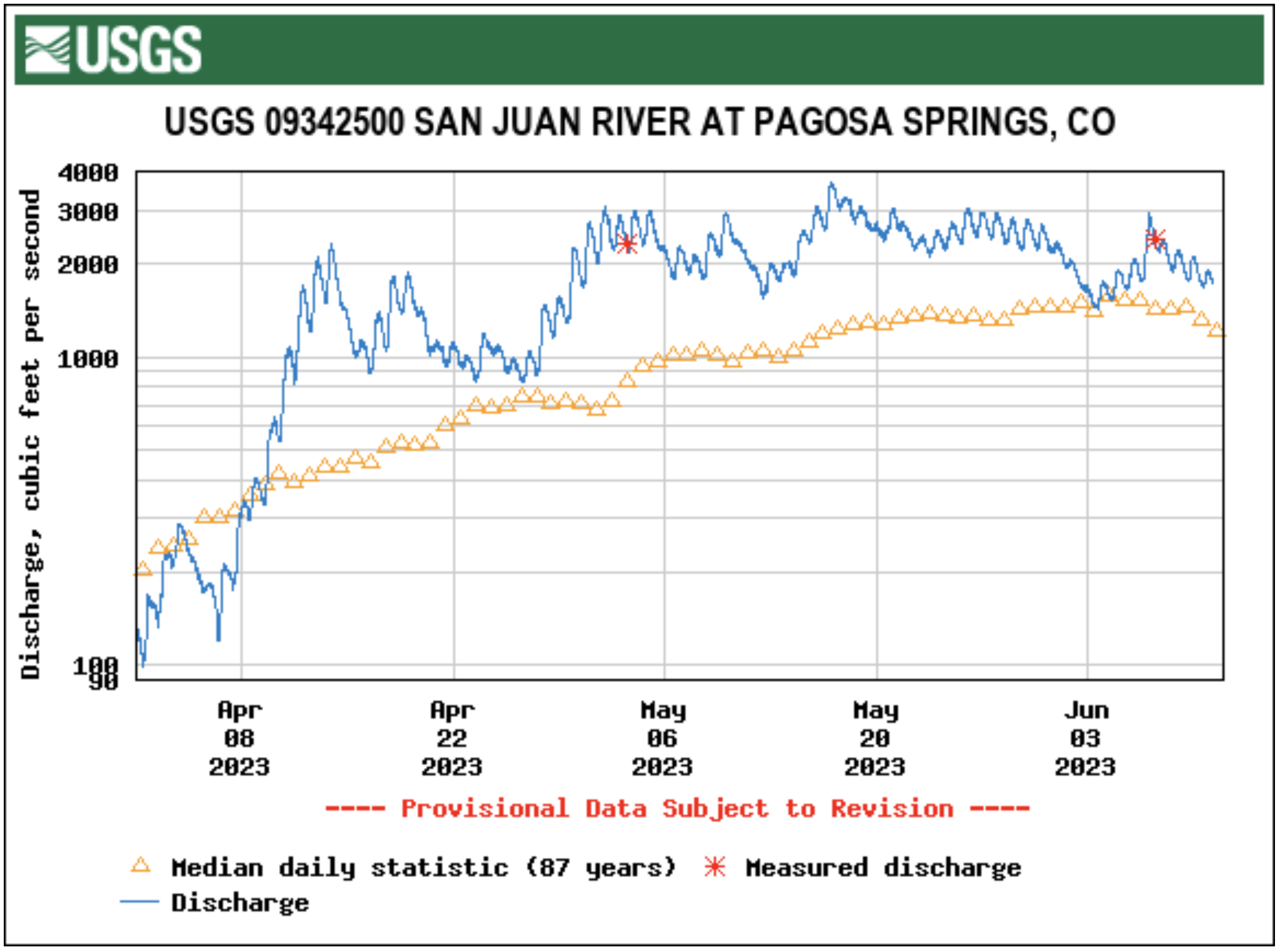
River levels across the region remain above average while the snowpack on Wolf Creek Pass was 79 percent of median as of June 7, according to the U.S. Department of Agriculture (USDA) National Water and Climate Center’s snowpack report. The USDA report indicates that the pass had 10.9 inches of snow water equivalent on Wednesday, June 7, below the median of 13.8 inches.
Area rivers also remain high, with the San Juan River in Pagosa Springs running at 2,470 cubic feet per second (cfs) at 9 a.m. on June 7, down from a nighttime peak of 2,930 cfs at 2 a.m., according to data from the U.S. Geological Survey (USGS). The mean flow for June 7 is 1,550 cfs, while last year’s flow on the date was 1,100 cfs, according to the USGS. The San Juan River has remained consistently above the median flow for the last 30 days, only briefly dipping below the median on June 4.
Other regional rivers are also high, with the Animas River in Durango flowing at 4,410 cfs at 9 a.m. on June 7, well above the mean flow of 3,100 cfs for that date based on USGS data. The Piedra River near Arboles was flowing at 1,980 cfs at 9 a.m. on June 7, according to the USGS, compared to a mean flow of 1,170. The Los Pinos River above Vallecito Reservoir near Bayfield was flowing at 1,090 cfs at 9 a.m. on June 7, according to the USGS, above the mean flow of 670 cfs. The Animas, San Juan, Los Pinos and Piedra rivers all saw sharp increases in flow levels on Wednes- day morning due to recent pre- cipitation, but, even before that, remained at or near median flows.
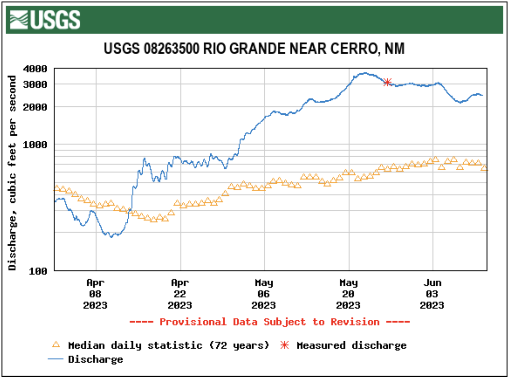
The Rio Grande River near Cerro, N.M., was flowing at 2,150 cfs at 9 a.m. on June 7, according to the USGS. This is considerably above the mean flow of 1,050 for the date. Cerro is the closest USGS monitoring station to the Rio Grande headwaters that provides cfs data. It is located to the north of Taos, N.M.
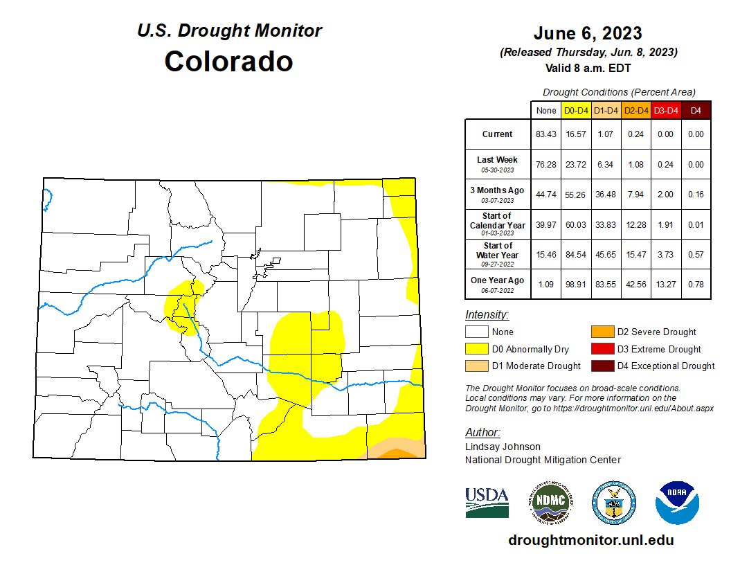
Colorado Drought Monitor map June 6, 2023.
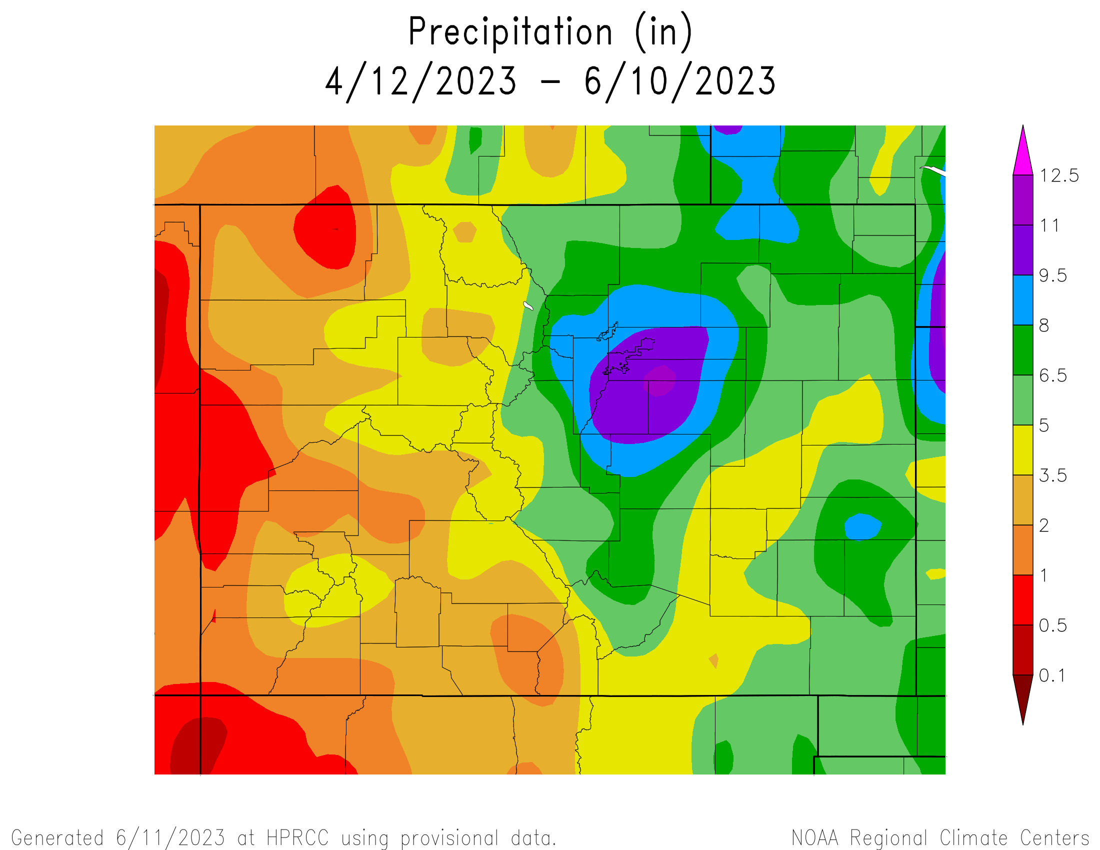
The National Oceanic and Atmospheric Administration (NOAA) National Integrated Drought Information System (NIDIS) pro- vides another view on current climate conditions, indicating that Archuleta County is not currently experiencing drought. The NIDIS indicates that April was the eighth driest in 129 years, with 1.3 less inches of precipitation than normal, but that January to April of 2023 has been the 26th wettest in the past 129 years with 2.25 more inches of precipitation than normal…
Pagosa Area Water and Sanitation District (PAWSD) District Engineer/Manager Justin Ramsey also noted the wet conditions and stated that all PAWSD reservoirs are full. He added that there has not yet been a call on water in the Fourmile Creek drainage, meaning that water is continuing to flow into Lake Hatcher. Ramsey stated he does not expect a call before early July given current conditions, which he noted would be significantly later than the median call date of approximately June 4. He added that last year the call of Fourmile was made in the middle of May.


