

Click the link to read the article on the Pagosa Springs Sun website (Josh Pike). Here’s an excerpt:
River levels across the region remain above average while the snowpack on Wolf Creek Pass was 79 percent of median as of June 7, according to the U.S. Department of Agriculture (USDA) National Water and Climate Center’s snowpack report. The USDA report indicates that the pass had 10.9 inches of snow water equivalent on Wednesday, June 7, below the median of 13.8 inches.
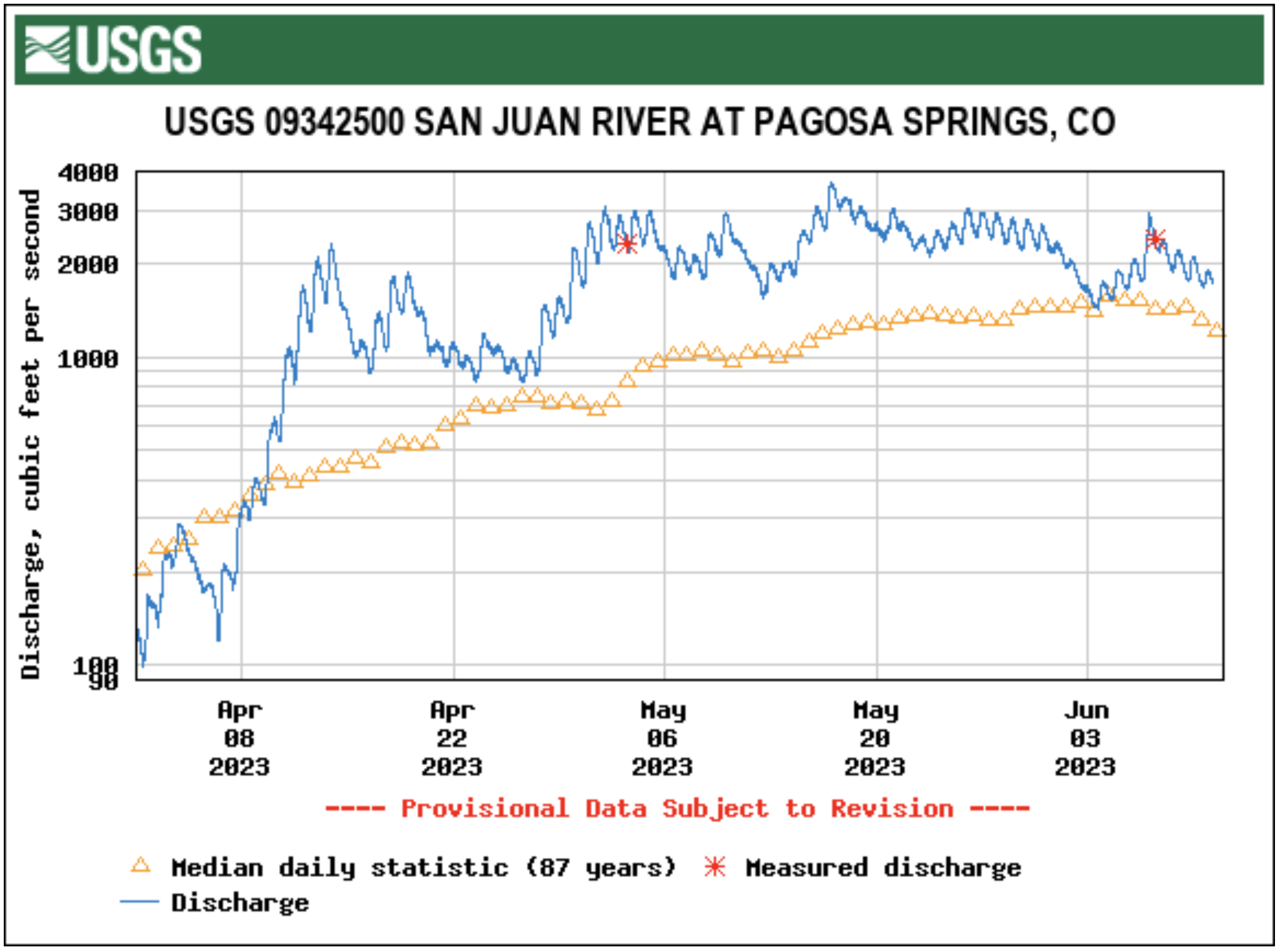
Area rivers also remain high, with the San Juan River in Pagosa Springs running at 2,470 cubic feet per second (cfs) at 9 a.m. on June 7, down from a nighttime peak of 2,930 cfs at 2 a.m., according to data from the U.S. Geological Survey (USGS). The mean flow for June 7 is 1,550 cfs, while last year’s flow on the date was 1,100 cfs, according to the USGS. The San Juan River has remained consistently above the median flow for the last 30 days, only briefly dipping below the median on June 4.

Other regional rivers are also high, with the Animas River in Durango flowing at 4,410 cfs at 9 a.m. on June 7, well above the mean flow of 3,100 cfs for that date based on USGS data. The Piedra River near Arboles was flowing at 1,980 cfs at 9 a.m. on June 7, according to the USGS, compared to a mean flow of 1,170. The Los Pinos River above Vallecito Reservoir near Bayfield was flowing at 1,090 cfs at 9 a.m. on June 7, according to the USGS, above the mean flow of 670 cfs. The Animas, San Juan, Los Pinos and Piedra rivers all saw sharp increases in flow levels on Wednes- day morning due to recent pre- cipitation, but, even before that, remained at or near median flows.
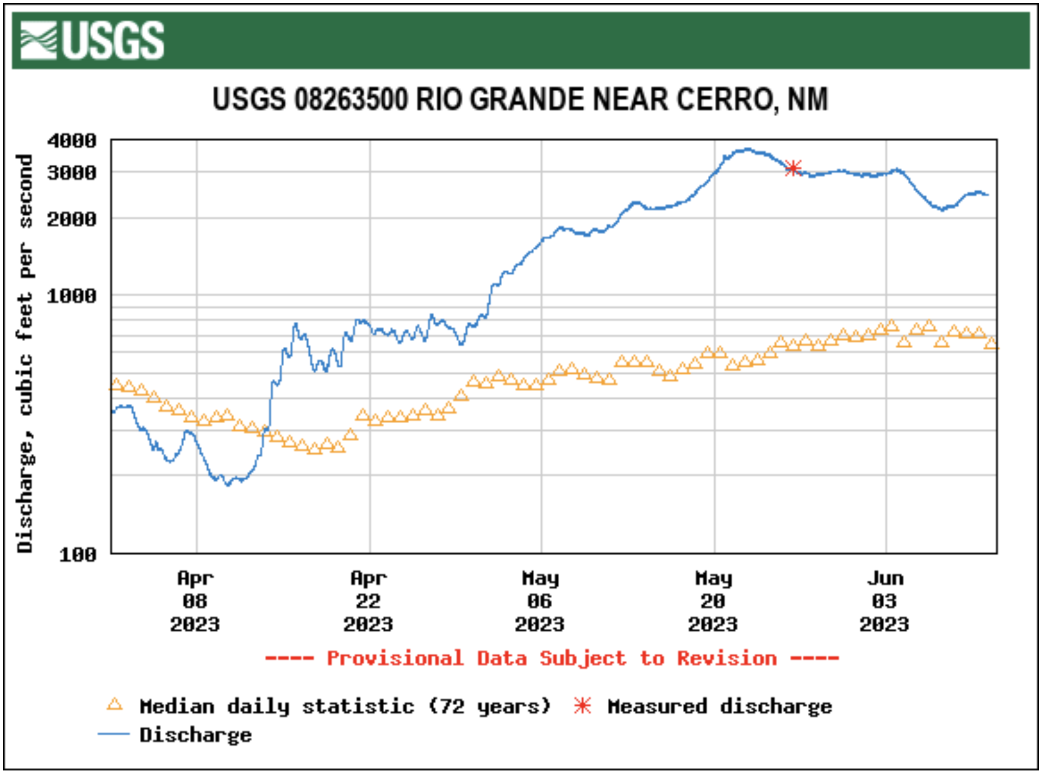
The Rio Grande River near Cerro, N.M., was flowing at 2,150 cfs at 9 a.m. on June 7, according to the USGS. This is considerably above the mean flow of 1,050 for the date. Cerro is the closest USGS monitoring station to the Rio Grande headwaters that provides cfs data. It is located to the north of Taos, N.M.
The National Oceanic and Atmospheric Administration (NOAA) National Integrated Drought Information System (NIDIS) pro- vides another view on current climate conditions, indicating that Archuleta County is not currently experiencing drought. The NIDIS indicates that April was the eighth driest in 129 years, with 1.3 less inches of precipitation than normal, but that January to April of 2023 has been the 26th wettest in the past 129 years with 2.25 more inches of precipitation than normal…
Pagosa Area Water and Sanitation District (PAWSD) District Engineer/Manager Justin Ramsey also noted the wet conditions and stated that all PAWSD reservoirs are full. He added that there has not yet been a call on water in the Fourmile Creek drainage, meaning that water is continuing to flow into Lake Hatcher. Ramsey stated he does not expect a call before early July given current conditions, which he noted would be significantly later than the median call date of approximately June 4. He added that last year the call of Fourmile was made in the middle of May.