2022 #COleg: To help refill two struggling underground aquifers, #Colorado lawmakers set aside $60 million to retire irrigation wells and acres of farmland — #Colorado Public Radio

Subdistrict 1 Program Manager Marisa Fricke clears paths for water to flow onto land the subdistrict owns. The property is one of the subdistrict’s investments in recharging the aquifer. Photo credit: The Alamosa Citizen

Click the link to read the article on the Colorado Public Radio website (Michael Elizabeth Sakas). Here’s an excerpt:

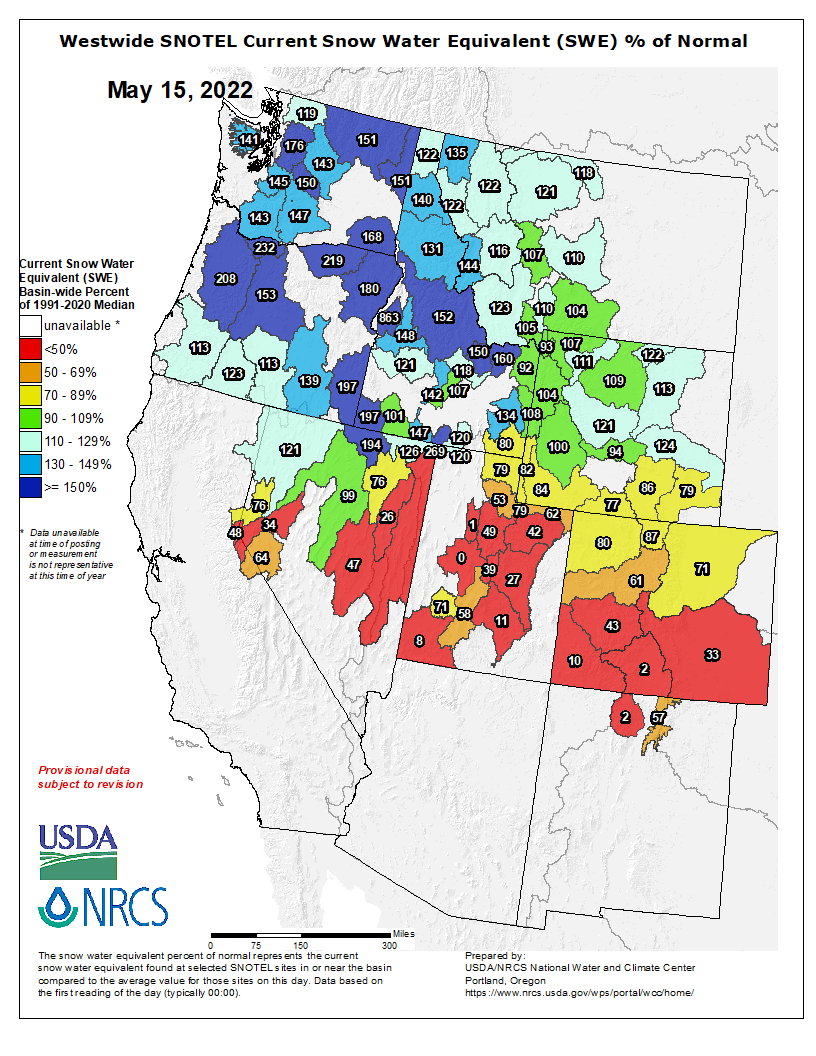
Colorado lawmakers unanimously voted to set aside $60 million of federal COVID relief money to create a fund to help water users in two river basins meet groundwater sustainability targets. If signed by Gov. Jared Polis, the legislation would create a groundwater compact compliance and sustainability fund administered by the Colorado Water Conservation Board. The money would be used to buy and retire groundwater wells used to irrigate farmland in the Rio Grande River basin in the south and the Republican River basin in the east to keep the water in underground aquifers that are struggling to keep up with drought and overuse…

Farmers and ranchers in both river basins face rapidly approaching deadlines to reduce their water use, which are necessary to maintain interstate river agreements and preserve underground water supplies. If these goals aren’t met, state water officials say there could be alarming consequences — and thousands of well users could face water cuts.

In the San Luis Valley, the state water engineer is requiring some groundwater well users to limit pumping because too many wells are all pulling from the same groundwater source. Chris Ivers, the program manager for two subdistricts in the Rio Grande Water Conservation District, said farmers and ranchers have levied property taxes on themselves to fund similar local efforts to meet groundwater sustainability goals.

#Snowpack nearly gone in parts of S. #Colorado as #drought worsens and fire danger persists (May 16, 2022) — TheDenverChannel.com #runoff

Westwide SNOTEL basin-filled map May 15, 2022 via the NRCS.

Click the link to read the article on TheDenverChannel.com website (Blair Miller). Here’s an excerpt:

Southern Colorado’s snowpack is already on its last legs, reaching levels for this point in May only seen twice in the past 20 years – 2002 and 2018, which were both marked by large and destructive wildfires and widespread drought. The Upper Rio Grande basin was at just 9% of median levels Thursday compared to the past 30 years – with just 0.6 inches of snow-water equivalent (SWE) remaining, according to U.S. Department of Agriculture data…

The San Miguel, Dolores, Animas and San Juan basin was at 18% of median snowpack levels Thursday, with 1.4 inches of snow-water equivalent remaining. In 2002, the worst year in the basin in terms of snowpack melt since 1991, the snowpack reached that level on April 26…

The Arkansas basin was 35% of median levels compared to the past 30 years as of Thursday, sitting at 2.5 inches of snow-water equivalent, according to the USDA data. This time in 2020, it was at similar levels. In 2018, the basin’s snowpack reached 2.4 inches of SWE on May 7, and in 2002, the worst year over the 30-year period, it reached 2.5 inches SWE on April 16…

The Gunnison basin was at 49% of median snowpack levels Thursday, with 4.3 inches SWE left. The Gunnison basin reached the same levels on May 6, 2018, and April 28, 2002, which was the year the snowpack there was gone the earliest.

The Upper Colorado River basin was at 66% of median snowpack levels as of Thursday…

The snowpack in the northern half of the state is faring better than southern Colorado’s, with the South Platte (76%), Yampa and White (84%) and Laramie and North Platte (92%) basins all above three-quarters of median levels as of Thursday. Statewide, the snowpack was at 64% of median as of Friday.

Story map: The #ColoradoRiver is in crisis, and it’s getting worse every day — The Washington Post #COriver #aridification

Colorado River headwaters tributary in Rocky Mountain National Park photo via Greg Hobbs.

Click the link to read the article on The Washington Post website (Karin Brulliard) and for the photos. Here’s an excerpt:

The Colorado River begins as mere streams in a marshy meadow 10,000 feet high in Rocky Mountain National Park. A few miles south, crystal-clear waters burble through the Kawuneeche Valley, its banks flanked in summer by wildflowers, spiky fallen trees and a dusty hiking trail. Small fish flicker over the stony bottom. The river is ankle-deep and narrow, hardly hinting at its outsize role as it twists down mountains, through canyons and across Southwestern deserts. But climate change, population growth, competition and other threats to the entire waterway are also vivid here in the headwaters region.

As temperatures rise, the mountain snowpack that feeds the Colorado river is diminishing over time and melting earlier. That decreasing runoff is more quickly soaking into Western Colorado’s parched terrain and evaporating into its hotter air. Less water is flowing downriver, depriving the ranchers, rafters, anglers and animals who depend on it.

“It feels to me like the future is accelerating really quickly now,” said Andy Mueller, general manager of the Colorado River District, which spans 15 Western Colorado counties. “We’ve been talking to our water users about the impacts of climate change and decreasing supply of water on the river for probably eight or nine years now. It’s really kind of hitting home.”

[…]

Middle Dutch Creek near the Grand River Ditch. Photo credit Greg Hobbs.

But even before the Colorado lands in the valley, distant demands on its water begin. About 30 percent of the runoff from the nearby Never Summer Mountains, which would naturally flow into the river, is diverted by a channel called the Grand Ditch and delivered to Colorado’s arid and fast-growing east.

It is one of dozens of ditches and tunnels and reservoirs that underlie a common complaint on this side of the Rockies: About 80 percent of Colorado’s precipitation falls here on the Western Slope. About 80 percent of the state’s population lives on the other side — and those residents think too little about where their water comes from, people in the west say.

Colorado transmountain diversions via the State Engineer’s office