Last week, [a Colorado online daily] ran an opinion piece about the dwindling Colorado River and what role agriculture may or may not play in helping to shore it up. It was written by Don Schwindt, a Cortez, Colorado, farmer, and Dan Keppen, Executive Director of the Family Farm Alliance. Along with praising a Southwestern Colorado dam, they argue that agriculture is important and “must be protected by ensuring water remains on-farm.”
They go on to say:
“Now, the narrative in some recent media coverage is even more troubling. For some, the current severe drought provides a platform to advocate taking water from farmers to make more available for cities and the environment.
“The hydrology of the West may be changing, but that should not drive hasty decisions. Agricultural water cannot be simply viewed as the default “reservoir” to meet other growing water demands.”
They are referring to “demand management,” which can include encouraging farmers to plant less thirsty crops, to increasing efficiency, to paying farmers to stop watering their fields and leave the water in the river (either buying water rights and permanently transferring them, or leasing them when needed on a temporary basis).
As I read the piece, I was struck less by the arguments, which were fairly predictable, than by my reactions to the arguments. One sentence would have me scoffing, the next nodding in agreement, and another both nodding and snorting derisively. That’s not because I’m insane. It’s because these issues—the “Law of the River,” agriculture’s role in culture and ecosystems, and the Colorado River system—are complicated as all get out. And that sometimes means that the only workable solutions to the growing problems on the river are not always vary palatable. I like farmers, for example, but I also like rivers and the fish in them. It’s getting more and more difficult to have both.
The following is an attempt at a Data Dump response of sorts to the column.
The Colorado River is facing a serious supply-demand imbalance. A century ago, when the framers of the Colorado Compact got together to divvy up the river’s waters, they made a few mistakes. First, and most egregious, they didn’t include tribal nations in the negotiations, despite the fact that tribes are sovereign nations and collectively are entitled to first rights to all the water in the river. That was just wrong. Second, they overestimated the amount of water in the river, which in some ways was an honest screw up, given the records they had to work from. And, third, they parceled out too big a portion of the water they thought was in the river, leaving too small of a buffer in case their calculations were off (they were).
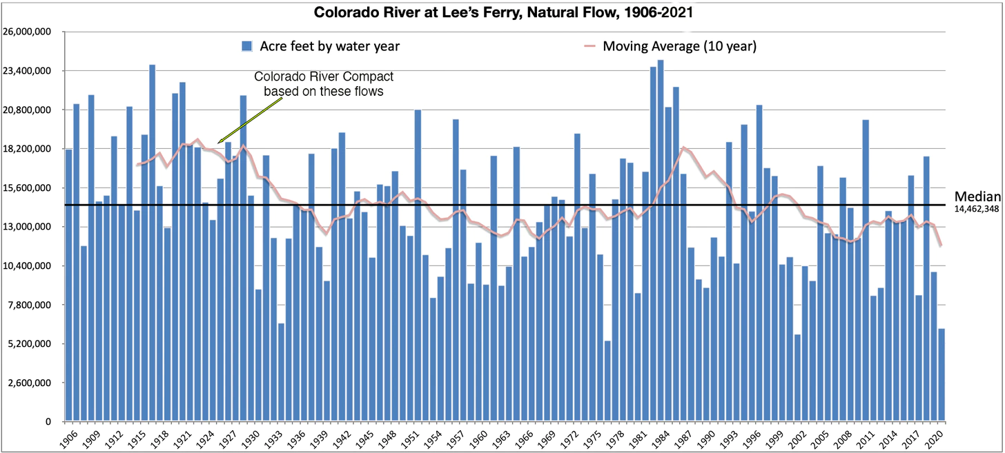
Natural Flow is an estimate of how much water would have naturally run past Lee’s Ferry if there were no dams or diversions upstream. It is calculated using the actual flow, historic flows, and upstream consumptive uses. Bureau of Reclamation modeling is complete to 2019; I extrapolated 2020 and 2021 based on Lake Powell inflows. The 1922 Colorado River Compact gave 7.5 million acre feet to the Upper Basin, 7.5 MAF to the Lower Basin, and (in the ‘40s) 1.5 MAF to Mexico, based on early 1900s observations. As the graph above shows, the average flows dropped below that level a decade later and stayed there aside from a brief respite in the 1980s. Source: USBR
The result: The river is over-allocated, and would be even if climate change were not a factor. So, supply was already lagging behind demand two decades ago, when the Southwest entered the megadrought in a dramatic way (i.e. 2002, the year of our desiccation). Now the supply is diminishing while demand holds steady, which is rapidly drawing down Lakes Powell and Mead (and other reservoirs). With those huge water “banks” at a critically low level, the Colorado River Basin is at its breaking point. Demand must be slashed, quickly and significantly.
While overall demand on the Colorado River trended upward from 1970 to the late 1990s, it plateaued when the region entered the current megadrought. Although this data only goes to 2010, the plateau has pretty much held. But at over 14 MAF per year, demand is significantly higher than what the river has supplied most years. Note that more water is lost to reservoir evaporation than is sent to Mexico. Source: USBR Colorado River Basin Water Supply and Demand Study.
The logical way to make big cuts in consumption is to go to the biggest consumers. And the biggest user of Colorado River water, by far, is not lawns, not golf courses, not the Bellagio fountain in Vegas. It is agriculture: all of those orchards, cornfields, alfalfa fields, ranches, and so on. It’s true in the Upper Basin, in the Lower Basin, and in each state except Nevada, which uses virtually all of its relatively minuscule portion of the river to keep Las Vegas from shriveling up and dissolving back into the desert.
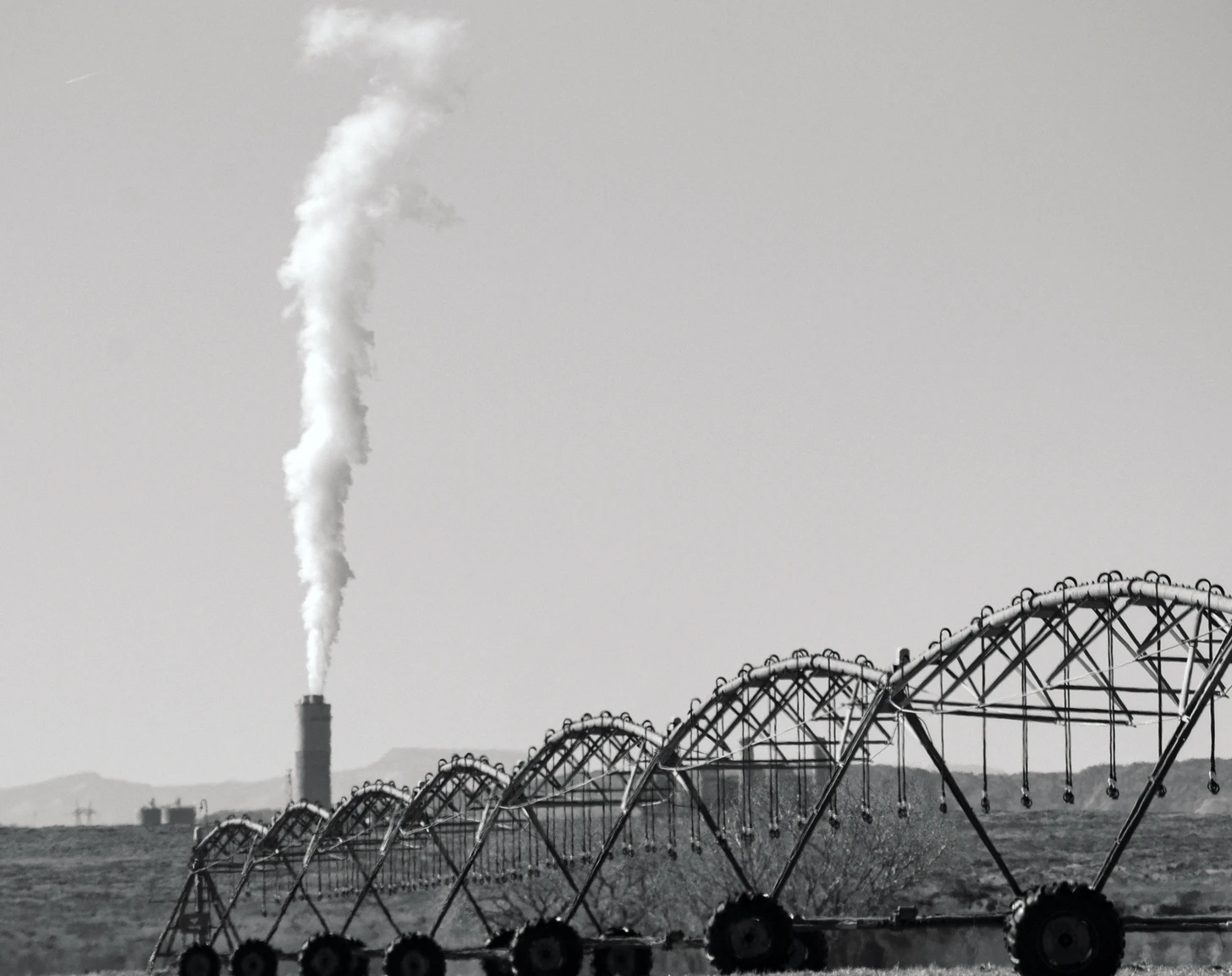
Please visit this post at http://LandDesk.org to see larger, higher resolution images. Note that in New Mexico energy takes up a relatively large share of water. This is mostly for the coal-fired power plants in the Four Corners region, which use billions of gallons of water each year for cooling, steam-generation and other purposes. In some cases, some of this water is returned to the river, but the San Juan Generating Station—scheduled to close this year—is a zero-discharge facility, meaning all of its water use is “consumptive.” Source: USBR.
Farms’ outsized water guzzling may seem surprising, especially since residential development has been gobbling up farmland in recent decades and ag makes up a smaller and smaller portion of these states’ economies. But crops need water in the arid West and, besides, the farmers tend to have most of the water rights. And Western water law and custom encourage folks to use all of the water they have a right to, conservation be damned—the motto, “use it or lose it,” is pounded into many a Western irrigator’s head: Take all of the water to which you’re entitled and then some, whether you need it or not, or else it might end up on your neighbor’s field or, God forbid, flow back into the river!
Montezuma Tunnel entrance.
Schwindt/Keppen write, in reference to diverting Dolores River water onto the farms of Southwest Colorado’s Montezuma Valley:
“The valley’s irrigated ecosystem also improved, further enhancing critically important environments for wildlife and generating other cultural benefits. Irrigated agricultural lands provide groundwater storage, open space, and riparian habitat and wildlife corridors. They also serve as important buffers between public wildlands and expanding urban and suburban areas.”
And it’s true, kind of. It’s a stretch to say irrigation enhances the existing ecosystem, but it certainly creates its own, new ecosystems which can be quite vibrant and beautiful. Leaky ditches are especially good at feeding new wetlands, willows, cattails, cottonwoods, and birds and other wildlife. But what irrigation bestows on previously arid landscapes, it takes from once wild rivers. That is especially true on the Dolores, where in the late 1800s irrigators began diverting its waters out of the Dolores River watershed and into the San Juan River watershed, meaning the runoff did not go back into the river. That essentially dried the lower Dolores right up.
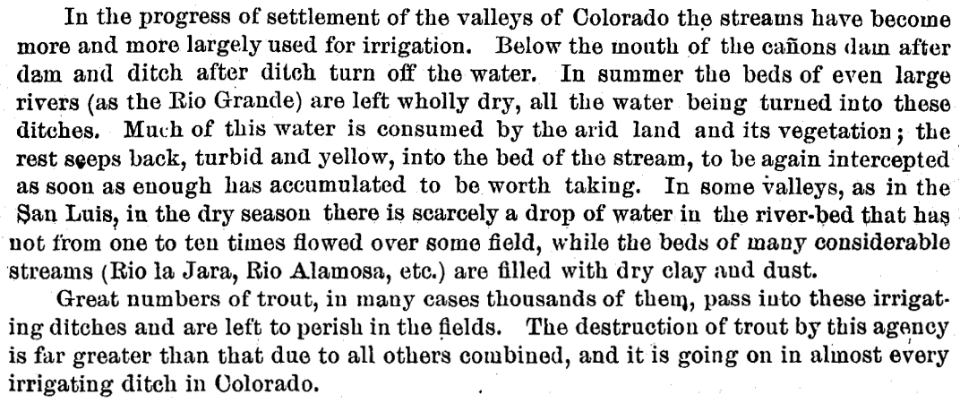
The same was happening all over the region. In the late 1880s ichthyologist David Starr Jordan surveyed area rivers. Here’s what he observed, not about the Dolores, specifically, but about the general state of streams in Colorado at the time:
Via The Land Desk.
But then came the Dolores Project, McPhee Dam and Reservoir, which Schwindt and Keppen say “put water in the dry Dolores riverbed.” Well, no, not really. What it did is take water out of the river during spring runoff and then release some of it later in the year into the riverbed that had been dried out by irrigation diversions.
The dam started impounding water in 1983, in the midst of a string of unusually wet years. During that era, the dam did its job. The current irrigators got a more stable supply of water. The Ute Mountain Ute Tribe got both drinking water from the project as well as enough to irrigate a major agricultural enterprise near the toe of Ute Mountain, providing much needed economic development. The Town of Dove Creek receives water from the project as do the formerly dryland farmers, allowing them to diversify their crops. And still the year-round flows below the dam were enough to build and sustain a cold-water fishery for trout in the first dozen or so miles below the dam and a habitat for native fish below that. In some ways the dam had set the stage for a win-win-win situation.
The Dolores River shows us what’s at stake in the fight to protect the American West — Conservation Colorado
Until it didn’t. That riverbed below the dam? It’s dry more years than not. Last year farmers had to fallow some or all of their fields. The Ute Mountain Ute Tribe received only about 10 percent of its usual irrigation water, forcing it to fallow fields; the Town of Dove Creek faced the prospect of losing its drinking water supply altogether; and releases from the dam for the lower river were cut to 10 cubic feet per second, a mere trickle. For several consecutive weeks in June and July the river gauge at Slickrock registered zero. Fish died off, boating has been nearly non-existent most years, and the dearth of high spring water has allowed tamarisk and Russian olive to proliferate.
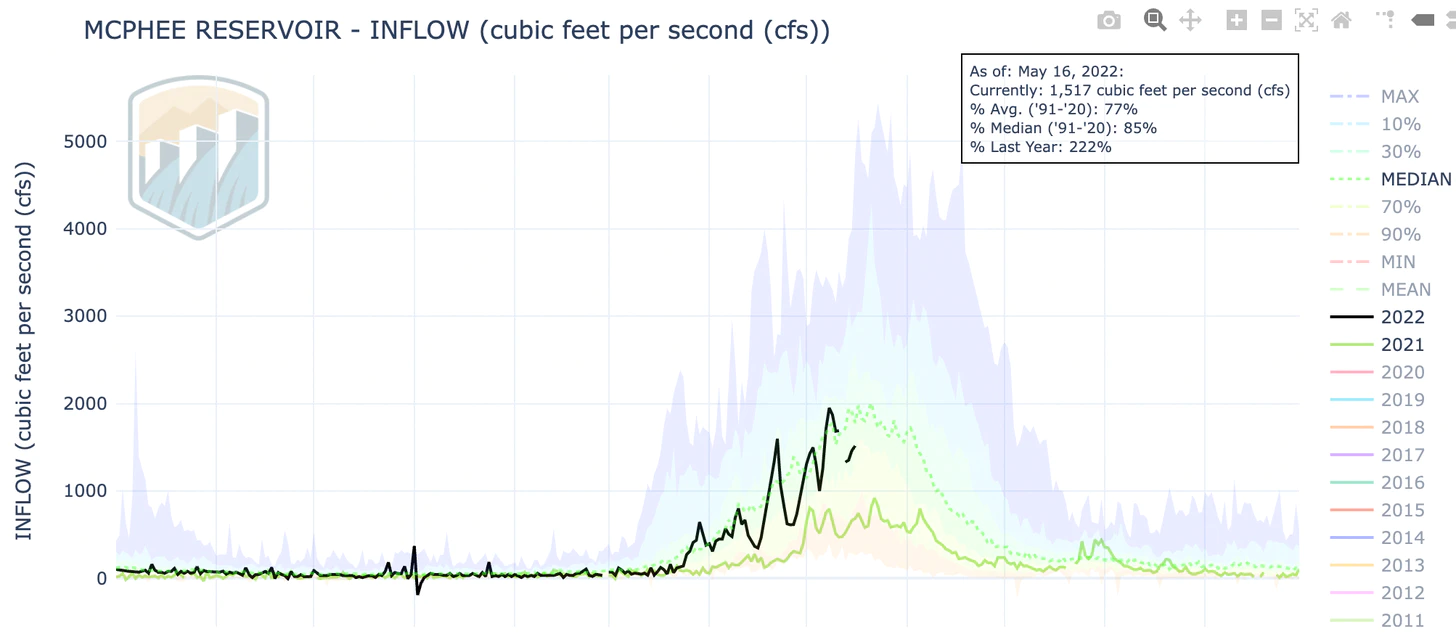
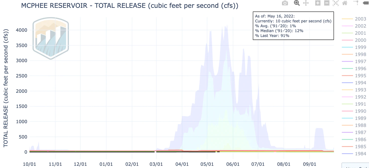
This spring’s flows on the Dolores River above the dam have actually been somewhat healthy, peaking out (rather early) at nearly 2,000 cubic feet per second.
And yet virtually none of that is making it past the dam (yes, that flat black line at the bottom represents releases. It’s at about 7.5 cubic feet per second, a mere trickle, and water managers say they will increase it to a whopping 25 cfs later this year, which is about enough to float a stick):
And even with good flows and low releases, Dolores Project irrigators are expected to get only 18% of their allocation this year. That’s up from 10% last year, but still. The dam isn’t doing the job it’s meant to do, which is to insulate users from drought. And yet, Schwindt and Keppen say the solution is not to try to reduce demand, but rather to “seriously assess projects that enhance water supplies.” They and the Farm Alliance suggest forest restoration, as well as building more water storage, i.e. dams. That won’t be enough.
Anyway, back to demand management. I think most of us can agree that farms shouldn’t be dried to allow cities to grow heedlessly, or to allow urban folks to water big lawns or keep parks green. And we can also all agree that everyone needs to manage their own demand, from the coal power plants to cities and towns to ski areas. Cities need to enhance efficiency and incentivize conservation by banning lawns, structuring water rates to discourage waste, requiring water-efficient appliances in new homes, and limiting growth. Reusing treated wastewater should be the norm. Coal plants should be shut down. Data centers, which can use as much as 1 million gallons of water per day, probably shouldn’t be sited in water-scarce areas (i.e. the Southwest).
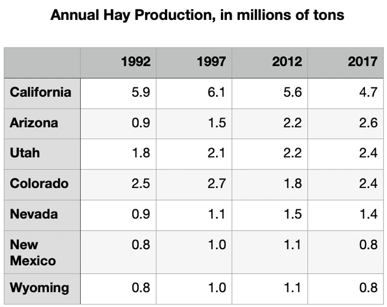
But as the consumption graphs above make clear, all of that will only go so far. Agriculture is the biggest consumer of water, so demand management in that realm will also pay the highest dividends. This doesn’t necessarily mean fallowing vast tracts of farmland. It might just mean irrigating more efficiently, plugging leaks on ditches, or switching to less water-intensive, more nutritionally dense crops. Land Desk readers will probably know what I’m saying: Maybe plant a little less alfalfa, instead of more of it!
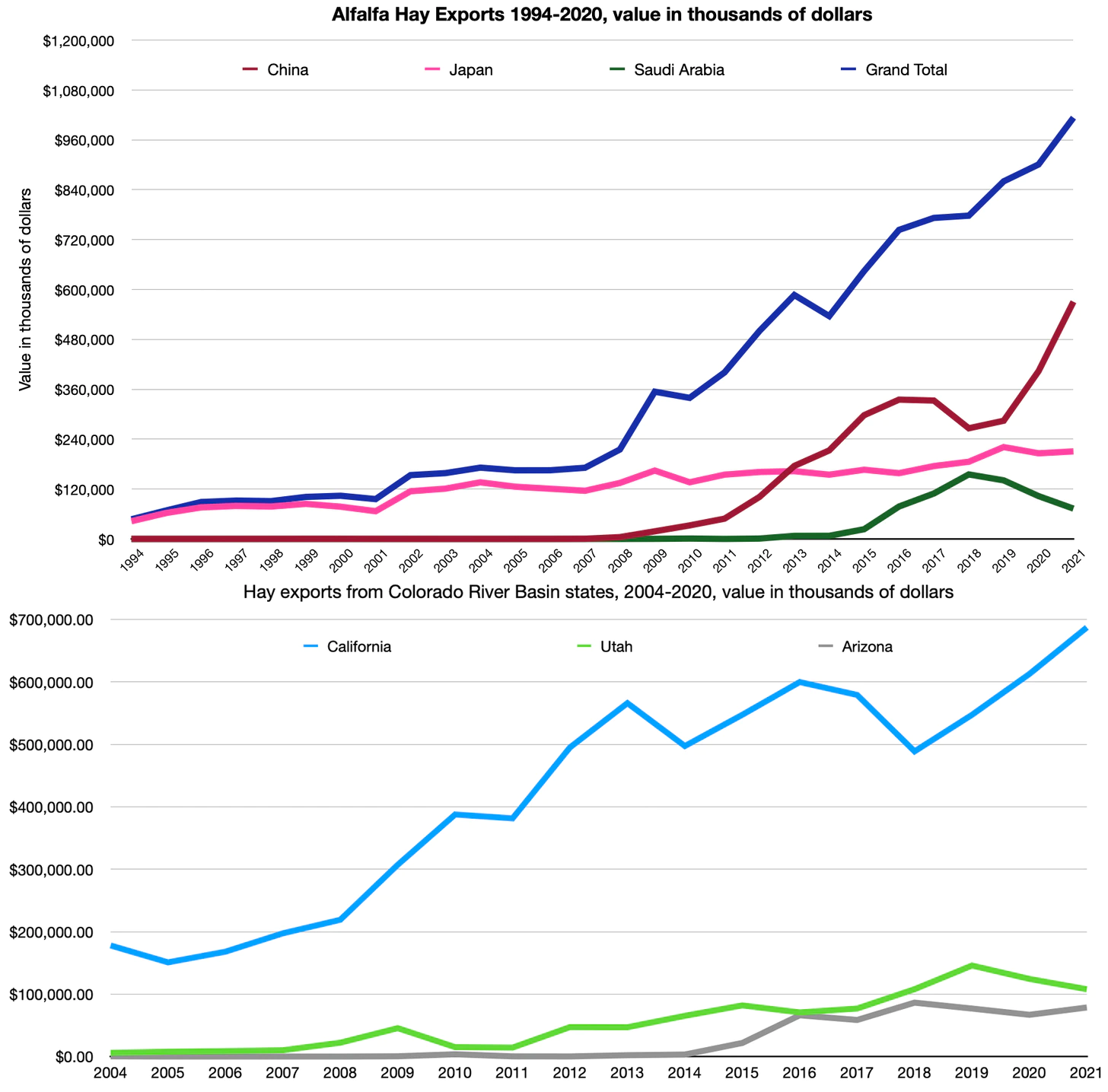
I know, I know, we need that alfalfa to feed the cows to make our cheeseburgers. I get it. But here’s the thing: A lot of that alfalfa is going overseas.
In other words, we are exporting our increasingly scarce Colorado River water—in the form of hay bales—to China, Saudi Arabia, and Japan. I think the agriculture industry can probably handle a little bit of demand management.