Click the link to read the release on the USDA website:
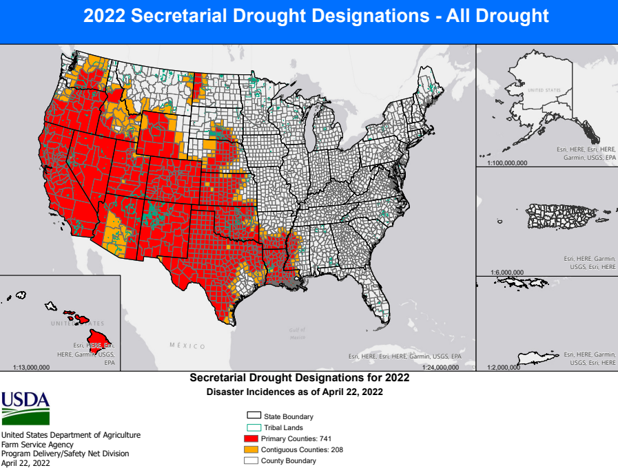
This Secretarial natural disaster designation allows the United States Department of Agriculture (USDA) Farm Service Agency (FSA) to extend much-needed emergency credit to producers recovering from natural disasters through emergency loans. Emergency loans can be used to meet various recovery needs including the replacement of essential items such as equipment or livestock, reorganization of a farming operation or the refinance of certain debts. FSA will review the loans based on the extent of losses, security available and repayment ability.
According to the U.S. Drought Monitor, these counties suffered from a drought intensity value during the growing season of 1) D2 Drought-Severe for 8 or more consecutive weeks or 2) D3 Drought-Extreme or D4 Drought-Exceptional.
Impacted Area: Colorado
Triggering Disaster: Drought
Application Deadline: Dec. 8, 2022
Primary Counties Eligible:
Click the image for a larger view.
Contiguous Counties Also Eligible:
Arizona: Apache Kansas: Cheyenne, Greeley, Hamilton, Morton, Sherman, Stanton, Wallace Nebraska: Chase, Cheyenne, Deuel, Dundy, Kimball, Perkins New Mexico: Colfax, San Juan, Union, Rio Arriba, Taos Oklahoma: Cimarron Utah: Daggett, Grand, San Juan, Uintah Wyoming: Albany, Carbon, Laramie, Sweetwater
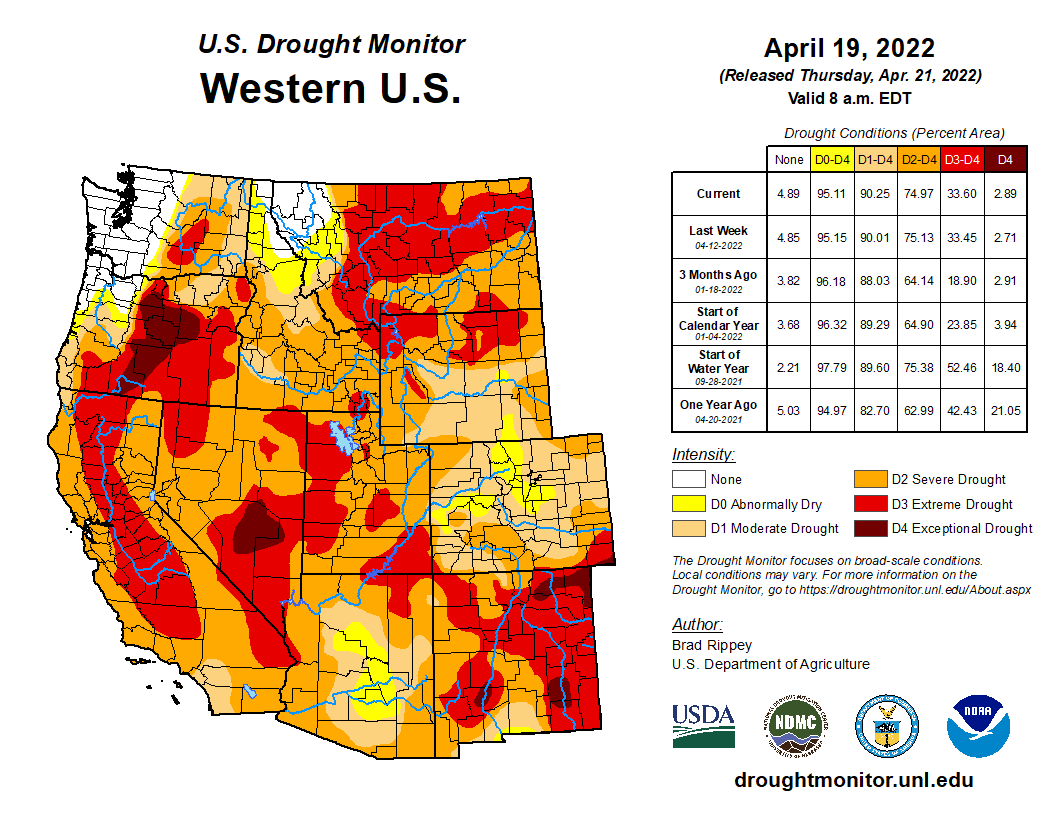
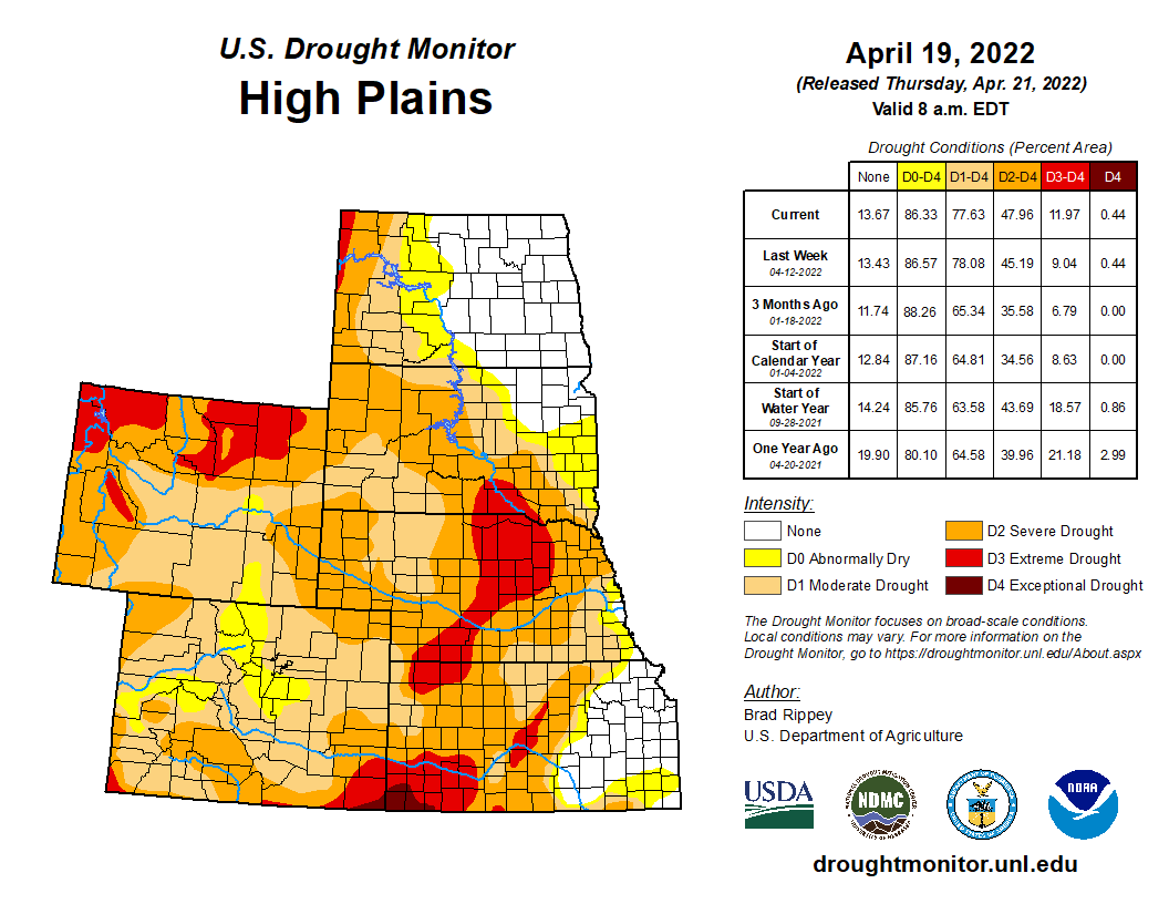
West Drought Monitor map April 19, 2022.High Plains Drought Monitor map April 19, 2022.
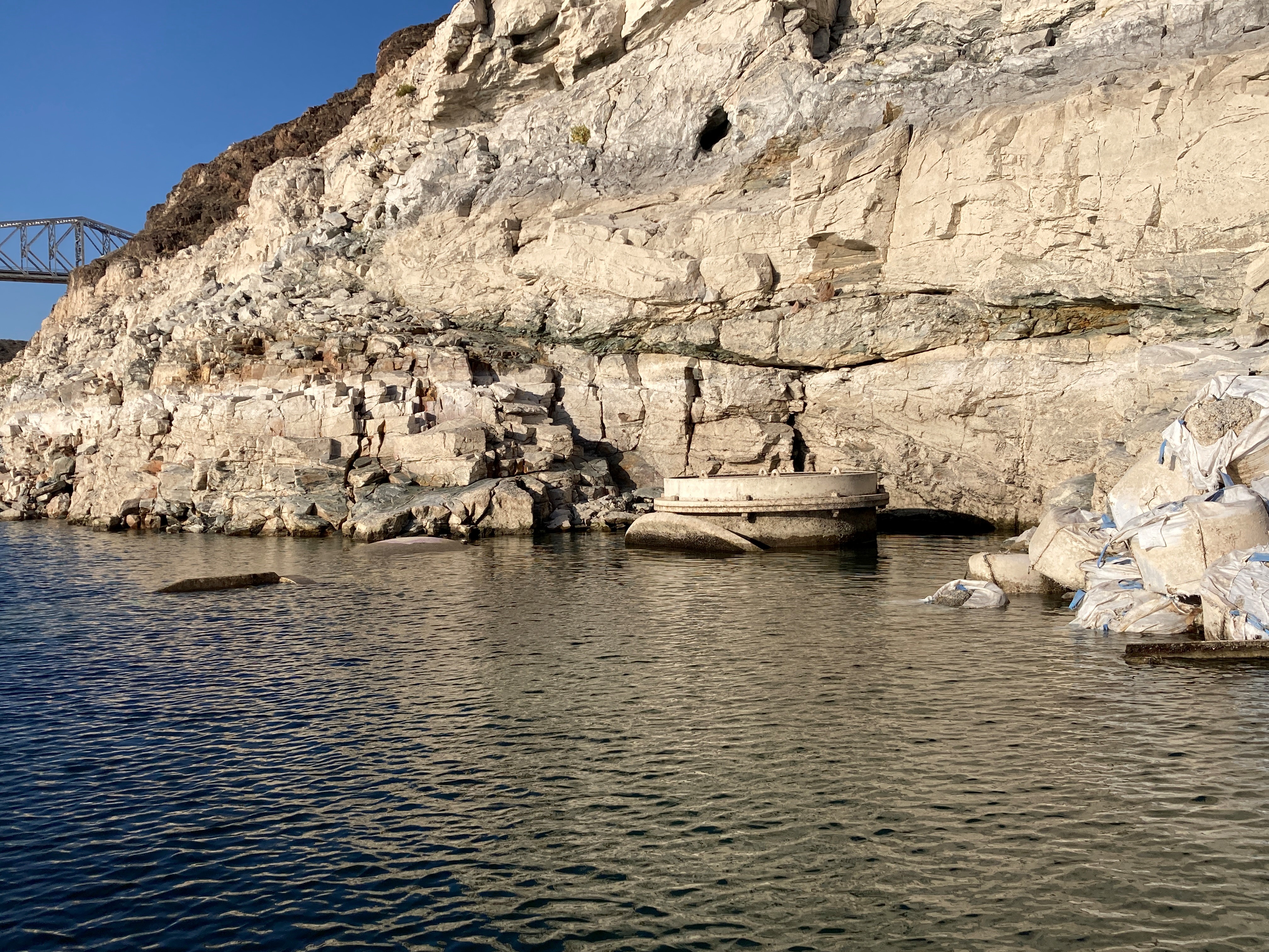
It's official – the top of Intake No. 1 is now visible and the low lake level pumping station is now operational. The new low lake pumping station was completed in 2020 to ensure the delivery of high-quality water in Southern Nevada. Learn more at https://t.co/o0rJqlXiFXpic.twitter.com/vPqULBlrCb
— Southern Nevada Water Authority (@SNWA_H2O) April 26, 2022
Las Vegas Lake Mead intake schematic, courtesy SNWA.SNWA intake #1 exposed April 2022. Photo credit: SNWAIntake #1 exposed. Photo credit: SNWAIntake #1 exposed. Photo credit: SNWA
Rio Grande and Republican River would use funds to meet state groundwater sustainability, interstate compact compliance targets
COLORADO is moving toward putting $60 million into a new groundwater compact compliance fund for the Rio Grande and Republican River basins created and funded through a state senate bill drafted and championed by state Sen. Cleave Simpson of Alamosa.
The bill, Senate Bill 22-028, creates the Compact Compliance Fund that would be administered by the Colorado Division of Water Resources and would receive an appropriation of $60 million from Colorado’s share of federal COVID relief money from American Rescue Plan funding.
The bill, co-sponsored by Sen. Jerry Sonnenberg of Sterling, originally only established the fund, and then an amendment unanimously adopted Thursday by the Colorado House Agriculture, Livestock, and Water Committee added $60 million into it. The bill next will be heard by the House Appropriations Committee.
“Given the unanimous votes every step of the way, so far, I am hopeful the bill with the appropriation will become law in the next week or two,” Simpson told Alamosa Citizen. “The timing of the availability of federal dollars and the growing sense of urgency in both basins created a unique opportunity that will serve both of these communities well. Still some work to do, but things look very promising for both of these Colorado communities.
Rio Grande and Pecos River basins. Map credit: By Kmusser – Own work, Elevation data from SRTM, drainage basin from GTOPO [1], U.S. stream from the National Atlas [2], all other features from Vector Map., CC BY-SA 3.0, https://commons.wikimedia.org/w/index.php?curid=11218868
If the Compact Compliance Fund is adopted by the Colorado Legislature it would pay for efforts to meet groundwater sustainability targets in the Rio Grande Basin and interstate compact requirements for the Republican River Basin. Each basin would get an earmark of $30 million to pay for efforts like retiring groundwater wells and other conservation and water sustainability measures. The goal would be to spend all $60 million within the time constraints put on federal COVID dollars, whether it’s a 50-50 split or not.
The Republican River basin. The North Fork, South Fork and Arikaree all flow through Yuma County before crossing state lines. Credit: USBR/DOI
The threat to livelihood for farmers and ranchers and economic disaster for the regions tied to irrigated agriculture in the Rio Grande and Republican River basins was made loud and clear in the House Agriculture, Livestock, and Water Committee.
“These farmers and ranchers have done everything they possibly can,” said Marisa Fricke, one of the Rio Grande Water Conservation District’s program managers. “They grow produce for us and hay for our cattle.”
Farmers and ranchers in both basins have levied property taxes on themselves through the water conservation districts to pay for their efforts to help the Rio Grande and Republican River meet groundwater sustainability and interstate compact compliance goals set by the state. It has meant fallowing of crop fields, permanently retiring irrigated acreage, taking groundwater wells off line either temporarily or permanently, and compensating farmers and ranchers for their efforts to help offset loss from less irrigated acres.
State Reps. Marc Catlin and Dylan Roberts made impassioned pleas for including $60 million of the ARPA money into the compact compliance fund during their presentation of the bill in the House Ag committee. Both are House sponsors of the bill.
“This is an opportunity with these funds to say, ‘We’re with you,’” said Catlin of the risk farmers and ranchers take their sacrifices to address compact and sustainability issues on the Republican River.
“This is a great bill for the San Luis Valley and Republican River Basin,” said Heather Dutton, district manager of the San Luis Valley Water Conservancy District. “Colorado through COVID relief bills provide a once in a lifetime opportunity to invest in our communities. The imbalance between water use and supply is a critical issue facing Colorado and especially the basins highlighted in this legislation.”
Farmers in the San Luis Valley are looking to take even more drastic steps in their efforts to meet state targets on groundwater pumping and recharging of the Upper Rio Grande Basin’s unconfined aquifer. In Subdistrict 1 of the Rio Grande Water Conservation District, farmers are facing a new proposed amendment to the subdistrict’s Plan of Water Management that would tie the level of groundwater pumping allowed to the natural surface water of the property. Some farms in the subdistrict do not have natural surface water, in which case they would have to purchase water credits from a neighboring farm or pay an overpumping fee of $500 per acre-foot.
This concept keeps the system in balance by replenishing what has been withdrawn from the aquifer with surface water and allows the community within Subdistrict No.1 to work together through the exchange and sale of credits. In the event that more groundwater is withdrawn from the aquifer and not replenished an overpumping fee of $500 per acre-foot would be assessed, according to the proposed amendment to the subdistrict’s water management plan. Money collected by the conservation district from an over pumping charge would come back to the Subdistrict 1 community in the form of payments towards enrolling in water conservation programs, according to Fricke.
“For over a decade farmers and ranchers have worked to meet sustainability levels and have taxed themselves assessments for waters taken out of the aquifer,” Fricke told House ag committee members.
Eventually the water conservation districts would establish guidelines and the state Division of Water Resources would administer drawdowns of the fund. In the unlikely chance Rio Grande and Republican River water managers didn’t spend all $60 million, the money would revert to the division of water resources.
Future state appropriations to Compact Compliance Fund would hinge on executive and legislative budget priorities.
Pawnee, a coal-burning plant near Brush, in northeastern Colorado, would be converted to natural gas no later than 2026, according to a proposal submitted to state regulators yesterday., It’s located a mile from where this writer and photographer emerged into the world. Photo/Allen Best
Click the link to read the article on the Big Pivots website (Allen Best):
A settlement agreement proposes an earlier coal plant retirement and a way way to evaluate need for new natural gas plants. It also punts some key decisions.
An agreement filed Tuesday with state regulators proposes a sharper, faster pivot by Colorado’s largest electrical utility from coal to renewables and alternative technologies.
The settlement agreement filed by Xcel Energy and other parties calls for retirement of Comanche 3, the state’s youngest and most powerful coal plant, “no later than” Jan. 1, 2031. Retirement could actually occur sooner.
As for new natural gas generation, the agreement calls for a new measuring stick: How cost-effective can the gas plant be if it operates only 25 years?
This could potentially result in Xcel Energy reducing carbon emissions from its electrical generation 88% by 2030 as compared to 2005 levels. As of 2021 Xcel’s electrical generation in Colorado was 39% carbon free.
But the proposal would also kick some major decisions down the road to 2024 and 2025. “The modeling and technologies need just a little more time to improve,” said Gwen Farnsworth, managing senior policy advisor in Colorado for Boulder-based Western Resource Advocates.
Among the items almost certain to be taken up in 2024 are questions of whether new programs and business models can be used to configure demand for electricity to better match supplies. For example, can batteries of electric cars be charged during the middle of night, when wind turbines in eastern Colorado most reliably whirl? Can peak demand be shaved more on hot summer afternoons? Such strategies and new technologies could reduce need for new generation, both fossil and renewables,
Those decisions include when exactly Comanche 3 needs to close. When the $1 billion plant opened in 2010, it was projected to operate until 2070. It has had a troubled history, a largely unreliable source of electricity with massive amounts of debt remaining. The 750-megawatt plant has been idled – again – since January, with no certain date for reopening.
Noting that lack of reliability, two of the three PUC commissioners in March indicated that they saw no good reason for the plant to remain operational beyond 2029.
Xcel last year proposed continuing operations to 2040, then agreed to a 2034 closing. This moves up the no-later-than date to the end of 2030.
“No-later-than is a key phrase, because it allows for flexibility and even improving the results of this settlement over time,” said Farnsworth. She said the accelerated retirement of Comanche 3 by just four years will save Xcel ratepayers up to $39 million.
And having Comanche off-line this year has helped save money because otherwise production from wind farms and other renewable generation would have been curtailed.
As for new natural gas, Xcel originally proposed 1,300 megawatts of “dispatchable” resources, meaning natural gas or other fossil fuels. Dispatchable resources can – at least in theory – be turned on quickly to meet demand. In practice, it’s more complicated. See Comanche 3.
How much natural gas?
Some of Xcel’s plans for natural gas remain. The coal-burning Pawnee Power Plant near Brush, about 90 miles northeast of Denver, is to be converted to natural gas no later than January 2026. Still in question is how much additional natural gas generation Xcel will acquire.
Xcel could still propose new burn natural gas plants to go on line in 2030, for example, but they would have to cease producing emissions by 2050.
But the settlement agreement also will result in new modeling that the Sierra Club’s Anna McDevitt says will allow battery storage coupled with renewable generation to better compete with natural gas in giving Xcel the confidence it can meet demands. Previous modeling used what the Sierra Club believes were flawed assumptions that favored natural gas.
“There is much in the settlement that will result in less likelihood of building new gas plants,” she said.
Xcel, in a presentation to investors in November 2021, estimated its Colorado division, would spend $9.9 billion from 2022 through 2026, not quite two-thirds for electric distribution and transmission but almost a quarter for natural gas.
Another major component of the plan calls for Xcel to continue property tax payments to Pueblo and Pueblo County districts from 2031 through 2040, the previous retirement date.
The proposal would have Xcel continue tax payments to Pueblo and Pueblo County until 2040.
Holy Cross Energy, the electrical cooperative serving the Vail and Aspen areas, owns 8% of Comanche 3. That translates to a potential 60 megawatts of production.
The agreement specifies that Holy Cross will be able to continue to use Xcel Energy’s transmission lines from eastern Colorado for an equal amount of electrical production, either from the resources owned by Holy Cross or from the new generating resources being brought on-line by Xcel in coming years.
Xcel’s plans for new generation, to be determined by competitive bidding, are estimated to include 2,400 megawatts of new wind, 1,600 megawatts of large-scale solar, 400 megawatts of energy storage, and nearly 1,200 megawatts of distributed solar resources.
“In a way, we are held harmless by the early retirement” of Comanche 3, said Bryan Hannegan, the chief executive of Holy Cross.
Holy Cross is currently projected to pay off its portion of the Comanche 3 debt in 2042.
Sedalia-based CORE Electric Cooperative, the state’s largest electrical cooperative, which serves Castle Rock and other suburban and exurban communities on the south flanks of metropolitan Denver, owns 25% of Comanche 3.
Hannegan and many others credited Xcel with a major achievement in getting a diverse set of parties – Boulder, Pueblo and other cities, as well as labor and business groups, environmental organizations, and still others – to come to a compromise.
Release of the agreement was accompanied by press releases from many organizations with a chorus of hosannahs.
“This agreement is a significant step toward meeting Colorado’s climate goals,” said Will Toor, chief executive of the Colorado Energy Office. “We’re so proud to lead the charge on reducing carbon emissions in Colorado,” said Alice Jackson, president of Xcel’s Colorado division. The Natural Resources Defense Council’s Noah Long also saluted a future of “savings for Xcel Energy customers and cleaner skies for Colorado.”
Farnsworth, of Western Resource Advocates, offered similar praise, but also pointed to a strong motivation: “I think the parties all made it possible because there’s a common understanding of the urgency of addressing climate change and also the urgency of moving this resource planning process forward in time to benefit from the federal tax credits for wind and solar.”
That, she added, made everybody want to reach compromise and avoid litigation.
The key word used by many was “flexible.”
Forward movement, but…
Not all were equally enthused. “Any date for shutting Pueblo unit 3 that isn’t 2022 is the wrong date,” said Leslie Glustrom of Boulder-based Clean Energy Action, referring to Comanche 3. “The climate crisis now clear to everyone.”
The Colorado Renewable Energy Society policy committee members were miffed that the social cost of methane was not used in the agreement as they had advocated.
“A big move forward, but there are pieces missing,” said the group’s Laurent Meillon. He charged that the plan still favors Xcel building generating facilities – that it can then use to justify higher rates to customers than necessary.
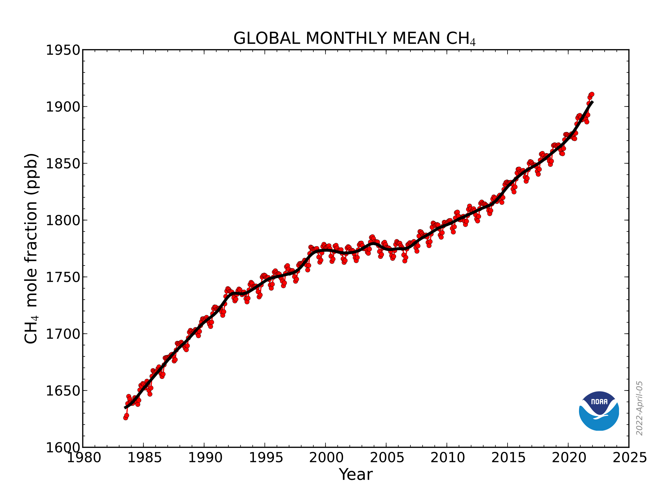
CH4 trend: This graph shows globally-averaged, monthly mean atmospheric methane abundance determined from marine surface sites since 1983. Values for the last year are preliminary. (NOAA Global Monitoring Laboratory)
“Xcel is orienting itself toward the construction of unnecessary gas plants, thus maximizing its investments and profits, right before it becomes entirely too obvious that only renewables and efficiencies are worthy of more investments. A repeat of its profitable coal mistakes, despite the current early coal closures with decades left to amortize those stranded assets,” he wrote in an e-mail.
CRES members, Glustrom and others say that Xcel must more aggressively pursue strategies that shave peak demands. Others involved in the agreement said they believe that those programs will become a central component of discussions in the middle of this decade. Xcel is beginning an update this summer of the thinking behind its programs.
All in all, how might this settlement be seen in a broader context – say, the United States? Farnsworth offers what must be considered a hometown view but one worth considering.
“Colorado might be on a smaller scale than some other states, but Xcel and this settlement are really on the leading edge.”
Solar installation in the San Luis Valley. Photo credit: Western Resource Advocates
Western Resource Advocates signed on to a revised settlement agreement filed today in Xcel Energy’s Electric Resource and Clean Energy Plan proceeding before the Colorado Public Utilities Commission. The new settlement includes accelerated dates for retiring the Comanche 3 coal unit, helps avoid building unnecessary and potentially stranded new fossil gas generation, and establishes commitments to achieve interim carbon emission reductions in 2024 and 2027.
“If approved, this settlement secures the next stage of Colorado’s energy transition, ensuring commitments from Xcel to reduce its harmful fossil-fuel emissions that contribute to climate change,” said Gwen Farnsworth, Western Resource Advocates’ managing senior policy advisor in Colorado. “The earlier date for retiring Comanche 3, plus cutting the assumed lifetime for any new fossil gas generation and establishing interim targets for reducing carbon emissions, will all help Colorado reach its climate goals. Important provisions also extend community assistance to the Pueblo community for 10 years and will help in the transition to new economic opportunities as the coal-fired Comanche unit closes.”
These are all key improvements to the settlement WRA has advocated for during the commission proceeding on Xcel’s plan. WRA opposed a previous version of the settlement signed by other parties late last year. Specifically, the new settlement calls for Xcel to:
Retire Comanche 3 by January 1, 2031 — four years earlier than the original settlement, which will avoid an additional 3.5 million tons of carbon emissions compared to the original settlement filed in November and will cut toxic local air pollutants in Pueblo;
Commit to interim reductions in carbon dioxide emissions, with targets of a 50% reduction by 2024 and 65% by 2027, compared with the utility’s 2005 levels;
Cut the modeled lifetime for any new fossil gas generation to 25 years; and
Expand Xcel’s Just Transition Plan, by extending the community assistance benefits for Pueblo to 10 years.
The settlement overall will provide more than 17 million tons of carbon dioxide emissions reductions. Reducing these fossil-fuel emissions will help curb the harmful effects of climate change. The Comanche generating station is also responsible for over 80% of all toxic chemicals released into the surrounding community of Pueblo.
Photo credit: Allen Best/The Mountain Town News
Several provisions in the revised settlement reduce the utility’s expected future reliance on fossil-fuel gas generation. According to the Intergovernmental Panel on Climate Change, reducing methane emissions from fossil-fuel gas is one of the biggest and fastest strategies for slowing climate change.
The Xcel settlement today follows the utility’s February 2021 announcement of its Clean Energy Plan committing to achieve an 85% reduction in carbon emissions and 80% renewable energy generation by 2030, as well as 100% clean energy by 2050. A 2019 Colorado law requires Xcel to reduce its emissions by 80% below 2005 levels by 2030. In 2019, the Colorado Legislature also passed House Bill 1261, requiring the state to reduce its economy-wide greenhouse gas emissions by 50% below 2005 levels by 2030 and 90% by 2050.
The amount of information Colorado water managers have about the state’s crucial snowpack is poised to swell exponentially over the next two years.
In mid-March, the Colorado Water Conservation Board, which aims to help water managers conserve, develop, protect and manage Colorado’s water, approved a $1.9 million grant to help pay for a plane stuffed with high-tech equipment to fly over Colorado’s mountains and measure the snowpack below.
Denver Water used Airborne Snow Observatory, or ASO, flights in 2019 and 2021 to gather data on the snowpack above Dillon Reservoir, the utility’s largest reservoir.
The information helps forecast how much water is expected to come tumbling down the mountain during the spring runoff — a critical time for collecting and storing water for the utility’s 1.5 million water users across metro Denver.
“Getting more and better information about the snowpack improves the accuracy of our spring runoff forecasts, and that helps us in many ways,” said Nathan Elder, water supply manager for Denver Water.
“With better information, we have a better idea of how the spring runoff could impact the environment and recreation, and whether we might have to go on watering restrictions during the summer. It also helps inform us on how we should manage all of water resources,” he said.
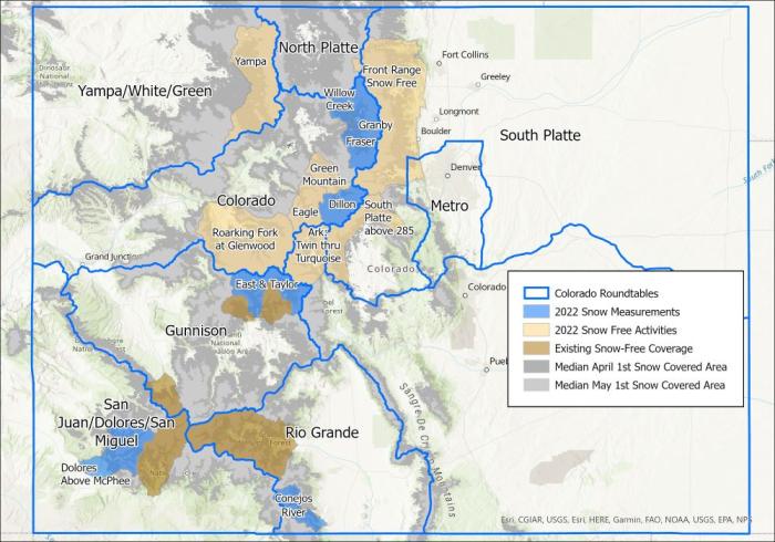
This year, in addition to getting ASO data about the snow in the Blue River Basin above Dillon, Denver Water also will get information about the snowpack in the Fraser, Granby and Willow Creek watersheds. Flights are scheduled for April and May, weather permitting.
The blue areas in the map above are where the Airborne Snow Observatory flights are scheduled to collect information about the snowpack in 2022. The light tan areas will be flown this summer and fall to collect baseline information about the ground when it is free of snow. Image credit: Lynker.
Based on NASA-developed technology, LiDAR equipment carried by the ASO planes use beams of light to measure the depth of the snow across entire watersheds and capture reflections from the frozen surface. Data from the flights over the snow-covered watersheds is compared to data collected when the same watershed is free of snow.
The resulting information from comparing the two sets of data tells water managers how much snow is on the ground and how much water it holds, augmenting data collected from SNOTEL sites, which also measure snowpack at selected sites, and decades of historical statistics.
The path of an ASO flight over the Blue River Basin, which flows into Dillon Reservoir, on Monday, April 18, 2022. Image credit: FlightAware.
“We see these ASO flights as a climate adaptation strategy,” said Taylor Winchell, a water resource engineer at Denver Water who works on climate change adaptation and water supply planning issues.
“As our snowpack changes with the changing climate, being better able to measure that snowpack becomes more important as more snow falls as rain, as the timing of the spring melt changes and as snow falls at ever-higher elevations because of warming. We can’t rely as much on historical snowpack datasets to understand the new snowpack reality.”
Winchell worked with water managers throughout Colorado to develop support for the state grant and create a collective known as CASM, short for the Colorado Airborne Snow Measurement group, that grew to include members from federal, state and local government levels, academia, the recreation industry and agriculture industries, as well as local nonprofits and environmental advocacy organizations.
The ASO flight path over the Fraser River, Willow Creek and Granby watersheds on Tuesday, April 19, 2022. Due to a state grant, this is the first year that airborne data from these watersheds will be available for water managers to study. Image credit: FlightAware.
“We had 37 letters of support for the initiative. To have that many groups supporting a water project, that’s unprecedented for a water project in Colorado. It’s rare to see so many people agree on something — but more accurate data helps everyone,” Winchell said.
In addition to flights over snow-covered mountain watersheds, the grant also will help pay for flights over snow-free ground — collecting essential baseline information that can be used to expand the snow-on flight areas even more next year and beyond, Winchell said.
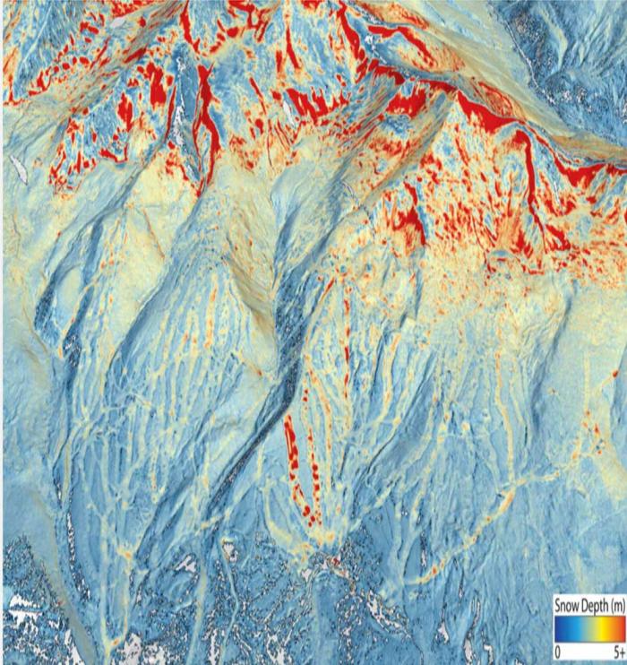
In this digitized image of the April 2021 snowpack above Dillon Reservoir, red splashes of color show where the snow was the deepest. The line of dots down the mountain is a ski run at Breckenridge Ski Resort where snow-making machines have added snow to the ground. Image credit: Airborne Snow Observatory Inc.
Work also will be underway this year to figure out how to continue the CASM program in the future, as the state’s grant is a one-year grant, Winchell said.
Denver Water managers are looking forward to seeing more ASO information about its watersheds, and also those throughout the state.
“How much snow falls outside our watersheds can affect Denver Water’s supply and operations just like the amount of snow that falls inside our watersheds,” Elder said.
“With this starting to become a statewide program, with data collected from more areas and that data being shared among the partners, it will help everyone better manage Colorado’s water supply.”
The Kortez dam below Seminoe Reservoir is a crucial part of a seven-reservoir water storage system on the North Platte River in Wyoming. (Dustin Bleizeffer/WyoFile)
Click the link to read the article on the WyoFile website (Dustin Bleizeffer):
April is typically when thousands of irrigators on the North Platte River — particularly along its tributaries — begin to divert spring runoff onto hayfields and crops, kicking off what they hope will be a productive growing season. Today, however, those with junior water rights are under new orders to curtail those critical early springtime diversions — a rare scenario that could prove costly for many farmers and ranchers in the state.
“When the water is coming, you’ve got one shot at it,” Upper North Platte Water Users Association Chairman Chris Williams said. Watching spring runoff flow downstream without tapping it is counterintuitive and frustrating for any ag producer, he added. “It has the potential to dry acres up.”
The “call,” or order, to restrict water diversions among North Platte River users with junior rights was initiated by the U.S. Bureau of Reclamation during the first week of April. The order, which is enforced by the Wyoming State Engineer’s Office, is set to expire at the end of the month. Water rights are prioritized based on a “first in time, first in right” doctrine. Those who gain rights to use water first have “senior” rights over those who gain water rights after them.
It’s unlikely the BOR will recommend extending the call, even if hydrological conditions and forecasts for the seven-reservoir North Platte River water storage system do not improve, according to Lyle Myler, acting manager for the Wyoming Area Office of the Bureau of Reclamation.
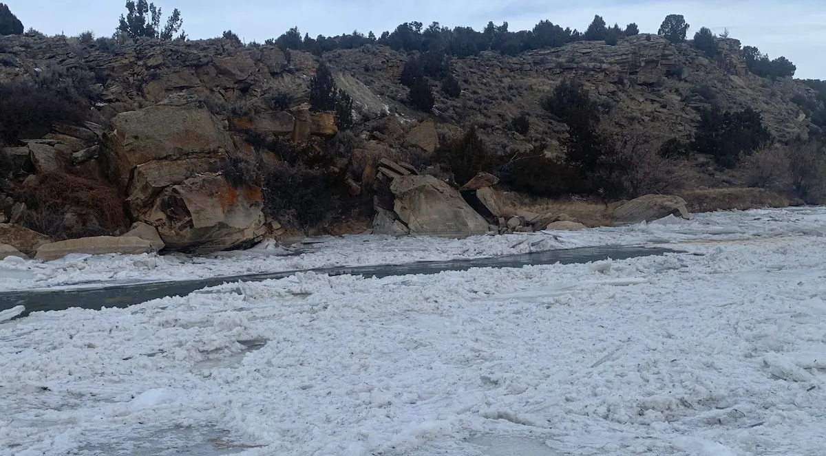
Ice crusts over the banks of the North Platte River near Casper in December 2021. (Dustin Bleizeffer/WyoFile)
“Our hope is that the curtailment of [junior] water rights will allow us to receive our share that’s allotted to us under our 1904 water rights, or as much as we can get,” Myler said.
Water users with junior rights on the Tongue River and its tributaries in northeast Wyoming are also on notice for similar, legally enforceable water conservation measures, following a call from Montana. Though no actual water diversion curtailment orders have resulted so far, those users will remain on notice until Montana officials remove the call, according to the Wyoming State Engineer’s Office.
‘Calls’ and climate
A call on a river or drainage system is a legal mechanism to order water conservation actions to help ensure minimum, legally required flows to users with senior rights to divert water — typically for irrigation. It can also apply to groundwater wells that pump from a drainage for municipal or industrial uses. In the event of a potential water shortage, those with junior rights can be ordered to forgo diverting water to help ensure that senior-rights holders downstream get their full allotment.
The BOR and water management authorities in Wyoming and Montana all cited low snowpack, persistent drought conditions and forecasts for lower-than-average precipitation for initiating the water conservation measures and notices.
“The Tongue River Basin has been experiencing drought conditions over the past year with below average winter snowpack and streamflow conditions,” according to an April 7 statement from the Wyoming SEO. “The North Platte River system has experienced multiple years of drought resulting in low reservoir storage carryover.”
Wyoming angler Jeff Streeter’s shadow casts over the shallow flow of the Encampment River — a tributary to the North Platte River — July 21, 2021. (Dustin Bleizeffer/WyoFile)
The conditions are consistent with climate trends that have pushed the statewide annual mean temperature upward by 2.2 degrees Fahrenheit from 1920 to 2020, according to National Oceanic and Atmospheric Administration data. The climate trend is also altering hydrological conditions in the state, such as lower snowpack and an earlier spring runoff season.
Despite current conditions and forecasts for lower-than-normal precipitation, however, it’s too early to know what spring may have in store, Wyoming State Engineer Brandon Gebhart said. If heavy spring snow and rain events do materialize, it could negate the need to curtail water diversions, he added.
The climate conditions contributing to the calls in Wyoming are likely to continue to force water managers to cooperate on conservation measures throughout the West, according to Utah Rivers Council Executive Director Zachary Frankel.
Clouds threaten rain over Pathfinder Reservoir, July 2019. (Dustin Bleizeffer/WyoFile)
“As our precipitation shifts from snow to rain, it is causing havoc on our water supplies, and that’s going to continue in coming years and decades,” Frankel said. “Although some climate model runs show increased precipitation — meaning more rain — it’s not likely to increase our total water supplies because of additional challenges from decreased soil moisture and a range of other challenges on the water demand side.”
Mandates
The BOR initiated the call on the North Platte River during the first week of April based on measurements and forecasts that indicate the seven-reservoir storage system might fill to only 950,000 acre-feet of water during this year’s “water season.” That’s below the Modified North Platte Decree’s call-triggering minimum of 1.1 million acre feet. The order applies to those with post 1904 water rights from the Wyoming-Colorado border to Guernsey Reservoir.
The Tongue River cascades over boulders near Dayton, September 2020. (Maggie Mullen/WyoFile)
In a separate action, the Montana Department of Natural Resources and Conservation issued a call on the Tongue River and its tributaries in Wyoming on April 1. The call is necessary to ensure that the Tongue River Reservoir in Montana fills this summer, and to otherwise hold Wyoming to account for legal obligations under the Yellowstone River Compact, according to Montana NRC Commissioner Anna Pakenham Stevenson.
Gebhart responded by notifying those with post-1950 water rights — junior rights — on the Tongue River and its tributaries that they may be ordered to curtail diversions at some point this summer. However, Gebhart and the agency’s Division II management that oversees the Tongue River drainage took issue with Montana’s initial assertions regarding forecasts for flows in the Tongue River.
Although both states acknowledged critical “data gaps,” the water storage and snowpack assessments initially cited by Montana should never have resulted in a call on the Tongue River, according to Gebhart. At the time, snowpack measurements for the drainage area measured more than 90% of the annual average. On April 19, it increased to 99%, according to a Natural Resources Conservation Service report.
Montana issued similar calls on the Tongue River in 2015 and 2016 based on more dire assessments than those cited this year, Gebhart said. But no orders to limit water diversions were necessary in response to either of those calls.
For now, both Wyoming and Montana continue to measure snowpack, water volumes and forecasts in the Tongue and greater Yellowstone River systems — hopeful that it might not be necessary to order irrigators to curtail normal irrigation practices, Gebhart said.
Dustin Bleizeffer is a Report for America Corps member covering energy and climate at WyoFile. He has worked as a coal miner, an oilfield mechanic, and for 22 years as a statewide reporter and editor primarily covering the energy industry in Wyoming. He served as MIT Environmental Solutions Initiative Journalism Fellow, John S. Knight Journalism Fellow at Stanford, communications director for Wyoming Outdoor Council and WyoFile editor-in-chief. He lives in Casper. You can reach him at (307) 267-3327, dustin@wyofile.com and follow him on Twitter @DBleizeffer.
Here’s the release from the Southeastern Colorado Water Conservancy District Board (Chris Woodka):
One newcomer is joining five returning members on the Southeastern Colorado Water Conservancy District Board of Directors. The appointments were made by a panel of District Judges in early April, and all six members were sworn into office Thursday, April 21, 2022.
Joining the Board is Matt Heimerich, 64, of Olney Springs, representing Crowley County. He will fill the four-year term of Carl McClure, who served for 17 years before retiring in 2022. The term will expire in 2025.
Heimerich is following in the footsteps of his father-in-law, Orville Tomky, who served on the Southeastern Board from 1988-2005.
Heimerich praised both McClure and Tomky at his first Board meeting for their contributions to Crowley County in dealing with the aftermath of water transfers of water from Crowley County that threatened to devastate the small rural county.
“Trying to bring a transmountain water diversion to the Arkansas Valley started in the 1920s and 1930s, and the need is as strong or stronger today,” Heimerich said. “What else can the Fryingpan-Arkansas Project deliver to meet the challenges faced by the people who live here? On the municipal side of the Project, what a difference it will make when the Arkansas Valley Conduit is completed.”
A New York native, Heimerich married Tomky’s daughter Karen in 1985, and began working in the family’s farming operation in 1987. The family continued farming after water from many of their neighbors’ farms had been sold to municipalities. He is a member of the Colorado Canal and Lake Meredith boards. He plans to make agricultural a priority while on the Southeastern Board.
Heimerich served from 1999-2011 as a Crowley County Commissioner, was on the Arkansas River Compact Administration board from 2007-2013, worked for the Palmer Land Trust in the Arkansas Valley office from 2014-2021, and is a member of the Water Education Colorado advisory board.
Reappointed, and serving four-year terms that expire in 2026 are:
Bill Long, President, a businessman from Las Animas, representing Bent County, first appointed in 2002.
Curtis Mitchell, Vice President, retired Fountain Utilities Director, representing El Paso County, first appointed in 2014.
Ann Nichols, Treasurer, retired General Manager of Finance for Colorado Springs Utilities, representing El Paso County, first appointed in 2006.
Alan Hamel, retired Executive Director of Pueblo Water, representing Pueblo County, first appointed in 1988.
Tom Goodwin, retired from the Forest Service and USDA, representing Fremont County, first appointed in 2011.
The Southeastern District was formed in 1958 to administer the Fryingpan-Arkansas Project, which was approved by Congress in 1962. The District includes parts of nine counties in the Arkansas River basin and brings water into the basin from the Fryingpan River basin on the western slope. There are a total of 15 Directors on the Board.