Click the link to read the article on the CBS Denver website (Ashton Altieri). Here’s an excerpt:
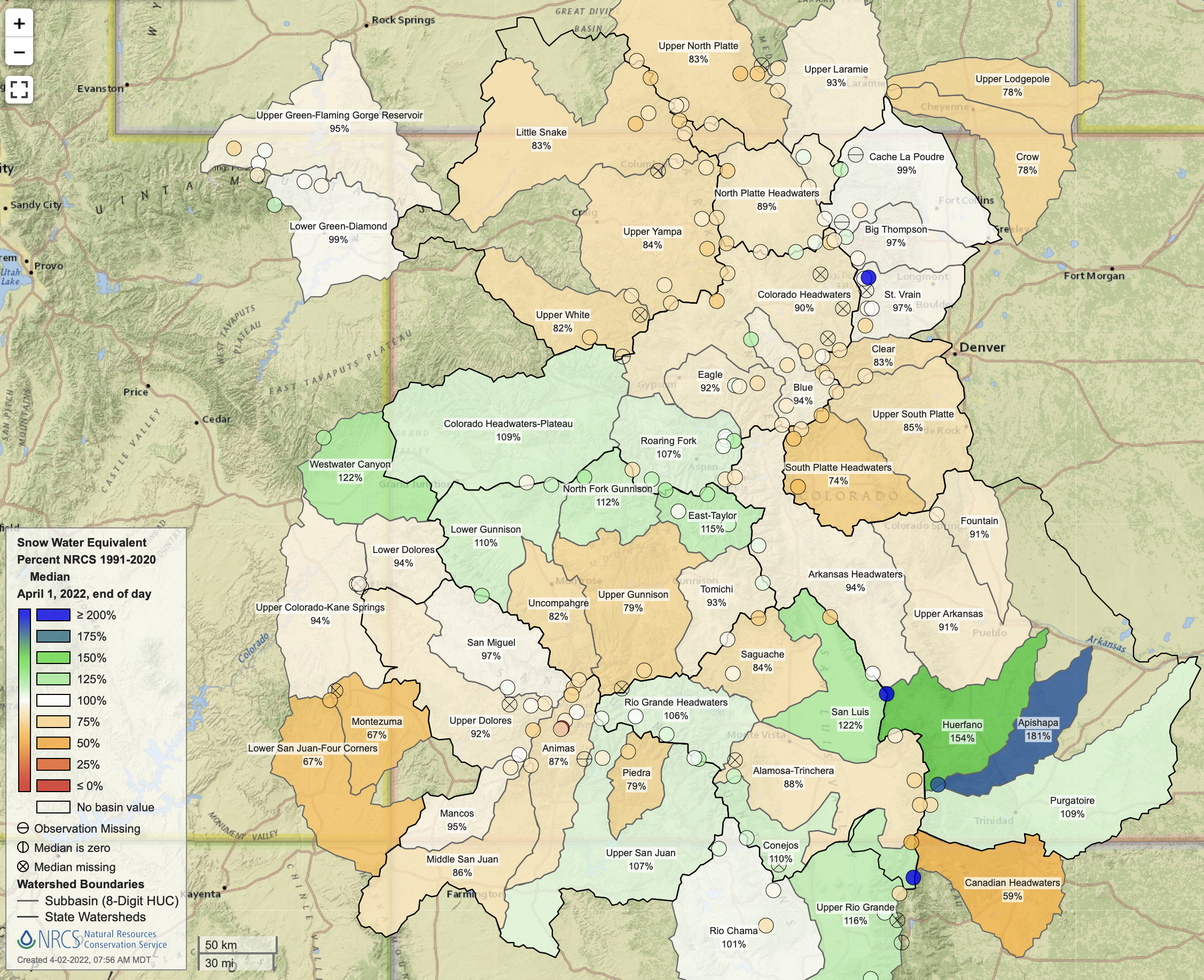
With the average date for peak mountain snowpack just a week away, only two of Colorado’s eight river basins are at or above normal. March was not as snowy in the mountains as it needed to be after a unusually dry January and February…As of Thursday morning, statewide snowpack was 8% lower than normal for the final day of March.
The Yampa Basin is in the worst shape with snowpack measuring only 83% compared to normal through the end of March. Ideally all eight river basins in Colorado would be at least 100% of average by the first week in April. The average date for maximum snowpack is April 8. After that date, the combination of a higher sun angle, longer days, and generally warmer temperatures means the snowpack starts to gradually disappear regardless of how many spring storms bring additional snow.
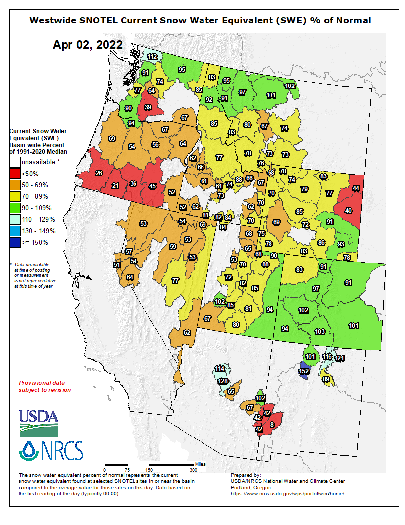
Westwide SNOTEL basin-filled map April 2, 2022 via the NRCS.
Every climate-enabled fire in Colorado should spark fury at the timidity that inhibits the state from taking serious climate action.
Every instance of climate blowback should prompt fierce campaigns of accountability.
Every time lives and property are threatened due to human-caused warming in the West, Colorado residents should demand a change in approach or, absent that, a change in leadership.
Another instance arrived last weekend.
The NCAR Fire south of Boulder ignited Saturday afternoon and forced the evacuation of an estimated 19,000 people in 8,000 homes. Severely drought-stressed fuels played a role in the fire’s advance on the city. Only three months ago, Boulder County was the site of the most destructive fire in state history — the Marshall Fire devoured more than a thousand homes, and was propelled by human-caused climate change. Extreme fires are becoming the norm in Colorado, which, along with other states in the Southwest, is facing climate-caused water shortages.
And — in the face of massive property loss, threatened public health, and loss of life — leaders in Colorado are proving unequal to the crisis.
GET THE MORNING HEADLINES DELIVERED TO YOUR INBOX
The state’s climate response looks comparatively good on paper. Its 2019 greenhouse gas emissions law, House Bill 19-1261, is one of the strongest in the country. It sets clear reduction targets compared to 2005 levels that the state must hit — 26% by 2025, 50% by 2030 and 90% by 2050. Gov. Jared Polis and members of his administration often employ the right rhetoric. During his State of the State address in January, Polis talked about “meeting the climate crisis head on.”
But in practice Polis prefers to meet the climate crisis only around the edges. The state is not on track to meet its own emission reduction targets, and even if it were, the targets increasingly appear too relaxed in light of the accelerating catastrophic effects of climate change throughout the world.
The Polis administration notes certain big-ticket climate-action achievements as evidence it is taking meaningful action. These include Xcel Energy’s Clean Energy Plan, new rules adopted last year that reduce dangerous methane emissions at oil and gas operations, and the state’s zero-emission vehicle standard, meant to ensure electric vehicles are available for sale in Colorado. This week Polis and several Democratic lawmakers announced a package of proposed air-quality measures at the Legislature.
But the state has delayed climate action, such as an Advanced Clean Trucks rule, or abandoned it, such as the Employee Traffic Reduction Program, on a comparable scale. The Polis administration has a maddening predilection for a “market-driven transition” to renewable energy and a feckless preference for voluntary industry action. The state is preparing for a dramatic increase in oil and gas production through about 2030. The result is that, at the current trajectory, the state likely won’t hit its own emission reduction targets.
The state must stop issuing new oil and gas drilling permits, and it must mandate a faster transition to renewable energy.
An Environmental Defense Fund analysis about a year ago concluded that the state was on track to achieve at best 16% reductions — not 26% — by 2025, and at best 26% — not 50% by 2030. Alex DeGolia, who leads EDF’s state climate strategy in Colorado and other states, told Newsline this week that a forthcoming updated analysis that accounts for the latest climate action in Colorado will show the state is still “well short of meeting its targets.”
We know what must happen if climate action is to measure up to the climate emergency.
The state must stop issuing new oil and gas drilling permits, and it must mandate a faster transition to renewable energy.
Several coal-fired power plants in the state continue to churn out pollution, and at least one coal-fired unit is projected to remain in operation beyond 2030. The state should not allow that to occur. Every coal-fired unit should be fast-tracked for closure at a quicker pace than currently planned, yet the Polis administration has an alarming tendency to favor the preferences of utilities over the health of the planet.
There are statewide efforts to encourage more electric vehicles, public transit, the electrification of home heating and appliances, and other areas that involve the participation of millions of individuals and properties. These are all worthy programs, but a transition to renewable energy would target several large sources of pollution; it’s cost-effective and it can yield significant short-term emissions reduction. What’s required to achieve such a transition is the willingness of Polis and climate advocates in the General Assembly to be bold. So far they instead have prioritized corporate interests and cowered before opposition from industry lobbyists and business advocates.
Opponents of a rapid, regulated transition to renewable energy argue that it could lead to higher costs and economic disruptions. Even if this were true in the short-term, the long-term costs of a failure to implement immediate and immense changes are incalculable, and the disruptions that should really command our attention are those endured by so many Boulder County families displaced by fire, and other climate victims throughout the state and the world. Climate action must also be more robust at the federal level and in other developed countries. But Coloradans have a responsibility to hold state leaders to account.
There will be another destructive wildfire. Drought will continue to pummel the West. Climate change will increasingly threaten public health. And with each new climate-enabled disaster, Coloradans should recall that state leaders chose half-measures and lip service over leadership.
SUPPORT NEWS YOU TRUST.
Colorado Newsline is part of States Newsroom, a network of news bureaus supported by grants and a coalition of donors as a 501c(3) public charity. Colorado Newsline maintains editorial independence. Contact Editor Quentin Young for questions: info@coloradonewsline.com. Follow Colorado Newsline on Facebook and Twitter.
Colorado Parks and Wildlife began restoration efforts this week to remove sediment from high spots in Home Lake just east of Monte Vista. Tyler Cerny, CPW District Wildlife Manager for the Monte Vista District, said sediment has accumulated in the lake for years primarily from the water inlet from the Lariat Ditch on the south side of the lake. With irrigation season slated to start in early April, plans are to remove as much sediment as possible before the water allotment is available. Fish restocking will begin as early as May or June with plans to include trout, bluegill, large mouth bass, catfish, grass carp and possibly crappie.
View down Clear Creek from the Empire Trail 1873 via the USGS
Click the link to read the article on the Canyon Courier website (Corinne Westeman). Here’s an excerpt:
Empire has confirmed there’s a leaking water pipe on private property, and there’s another suspect area underneath U.S. Highway 40.
Police Chief John Stein stated on April 1 that, while the leak on private property was confirmed to be drinking water, it was relatively small compared to the town’s overall system. So, it cannot be the sole cause of Empire’s loss in water last month, he described.
The suspect area underneath U.S. 40, which Stein said could be a valve that isn’t shutting completely or a cracked pipe, requires further research. If it’s a valve that’s not closing completely, water might not be leaving the system in that location, he explained.
Stein said he couldn’t guarantee it, but Empire’s water woes could be from these two problems plus residents’ relatively high water use during last month’s cold spell.
It’s still possible, he continued, there is a larger issue with the water infrastructure that the town and its partners haven’t identified yet.
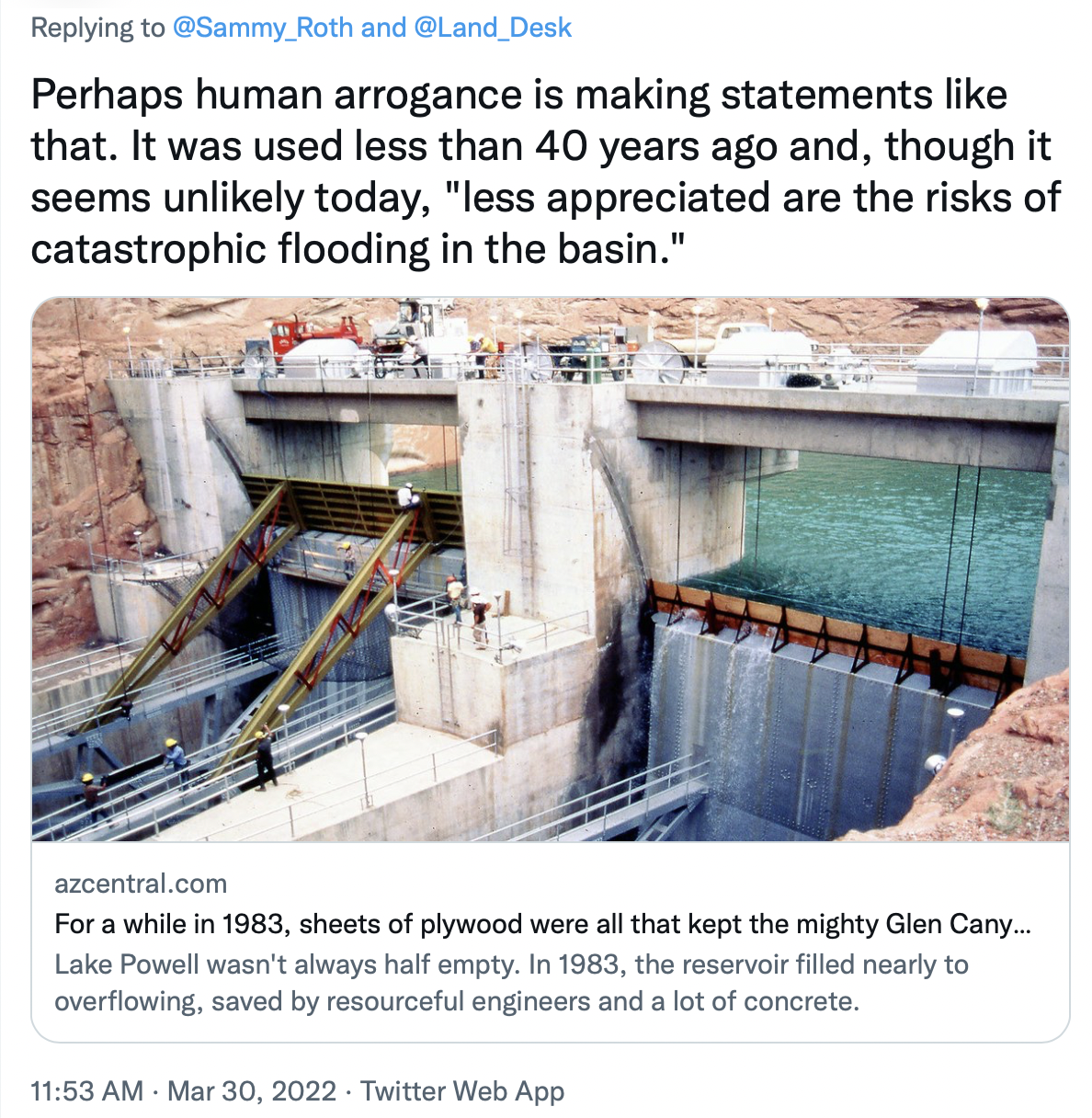
A rare sight: Water shoots out of Glen Canyon Dam’s river outlets or “jet tubes” during a high-flow experimental release in 2013. Typically all of the dam’s outflows go through penstocks to turn the turbines on the hydroelectric plant. The outlets are only used during these experiments, meant to redistribute sediment downstream, and when lake levels get too high. Spillways are used as a last, last resort. The river outlets may be used again in the not so distant future: Once Lake Powell’s surface level drops below 3,490 feet, or minimum power pool, water can no longer be run through the turbines and can only be sent to the river below via the outlets. This is cause for concern because the river outlets were not built for long-term use. Jonathan P. Thompson photo.
If you read my impressions from a visit to Hoover Dam, you’ll remember that I ended it with these sentences describing the spillway at the dam (not the dam, itself): “It’s beautiful in the way functional structures can be. And yet, it no longer serves any real function—and never will—except, perhaps, as a reminder of what was.”
When the venerable LA Times environment reporter Sammy Roth tweeted out the description, this was one of the responses:
Okay, well, I’m not sure how it’s “arrogant” to say that a spillway will never be used again, but a subsequent Twitter discussion fleshed out the bigger point he was trying to make: Just as climate change can exacerbate drought, warming can also trigger extremely abundant precipitation, leading to catastrophic flooding a la 1983, which could fill up the reservoirs again and put the spillways back into use. Others piped in, as well, pointing to Lake Oroville in California, which went from nearly empty to overflowing and back to empty over the course of several years.
It got me thinking that maybe I had been too rash in asserting the spillways would never be needed again. After all, anything’s possible: We know that the 1911 Flood sent around 300,000 cubic feet per second or more past the current Glen Canyon Dam site (compared to the 1983 flows of 120,000 cfs), and paleoflood investigations suggest deluges in the distant past have topped out above 600,000 cfs—a Biblical sort of event.
Could a climate change-induced megaflood of this magnitude reverse the effects of a climate change-induced megadrought and fill Powell and Mead back to the brim?
It seems unlikely.
The issue here is one of scale. Lake Powell and Lake Mead are both gargantuan in size. Powell is 186 miles long when full with over 1,900 miles of coastline. It can store nearly 27 million acre feet (af) of water (minus a million or two due to siltation). Contrast that to Lake Oroville, with its relatively minuscule 3.5 million acre feet of capacity.
Powell currently has less than 6 million acre feet in it, leaving 20 million acre feet of empty storage that needs to be filled before water would reach the spillways. Lake Mead’s numbers are similarly huge.
Now, the monster flood of 650,000 cfs would dump 1.3 million acre feet of water per day into the reservoir. So, you’d need two weeks of this to fill up Powell—and Lake Mead would still have 20 million acre feet of unused capacity, meaning you’d need another two weeks of deluge to fill it up. Megafloods usually don’t last that long—the 1911 Flood brought up river levels for several days, not weeks (and Colorado river flows for the entire year were unremarkable). And besides, 650,000 cfs isn’t going to sneak up on the dam operators. They’d see it coming and start releasing water from the reservoirs ahead of time, obviating the need to use the spillways.
Conclusion: A sudden megaflood is not going to cause either Mead or Powell—and certainly not both of them—to overflow.
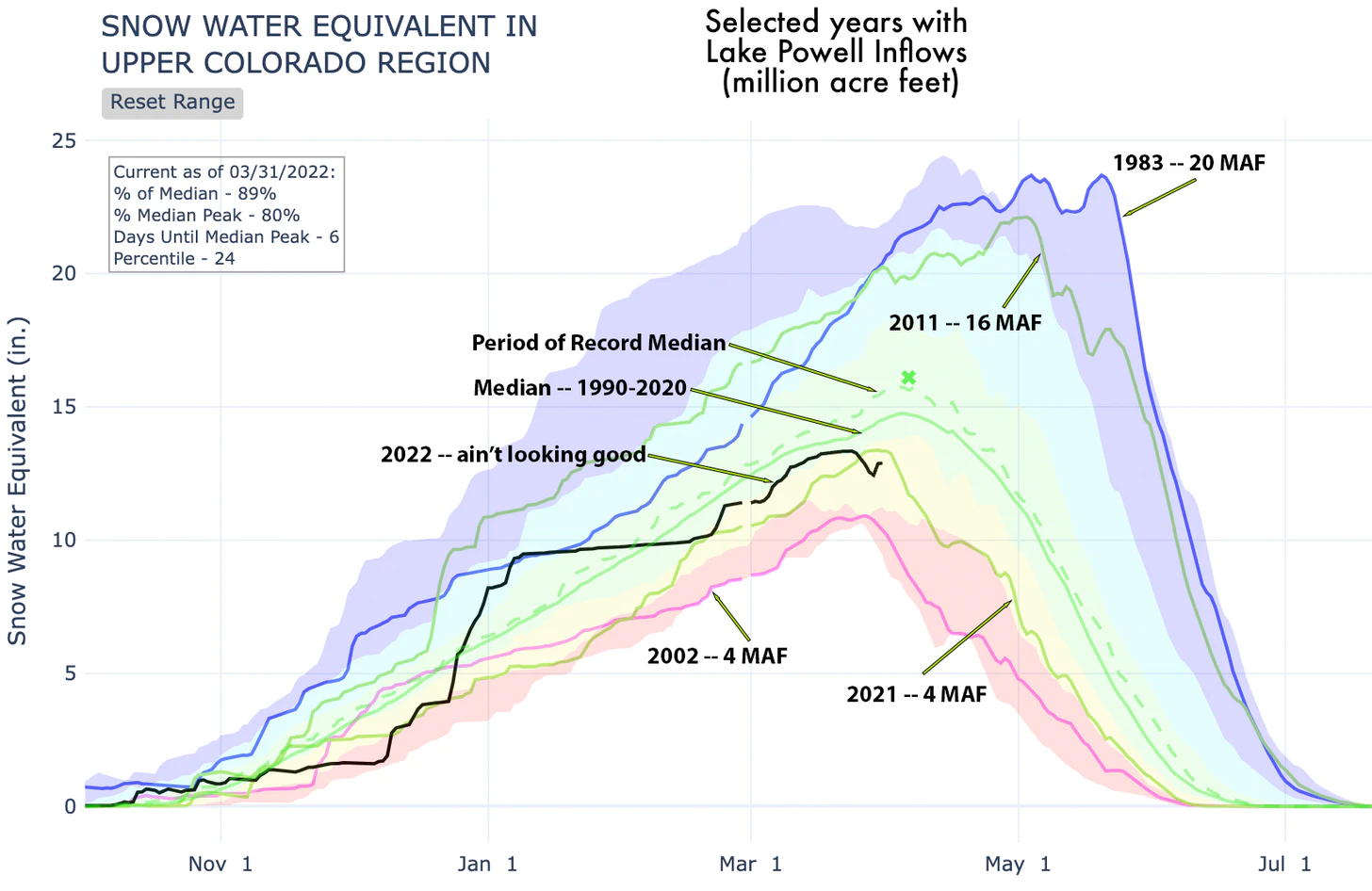
But what about a string of really wet years, when record-setting snowfall is followed by torrential summer rains? We know this is possible, because it’s exactly what happened in 1983 through 1986, the last time the spillways were used. We also know, from streamflow reconstructions back to the 8th Century, that the wet and wild 1980s were not entirely unprecedented. They were, however, an anomaly, and they are among the wettest four consecutive years on record.
So, let’s assume a repeat. Would that fill the dams to overflowing and put the spillways back to use? Perhaps.
Here are the numbers as of March 30:
Lake Powell Current storage: 5.8 million acre feet (MAF)
Full capacity: 27 MAF
Minimum annual release: 8.23 MAF
Annual evaporation: .4 MAF
Lake Mead current: 8.6 MAF
Full capacity: 28.2 MAF
Minimum annual release: 9.6 MAF
Annual evaporation: .6 MAF
Las Vegas withdrawal: .3 MAF
These were the actual inflows into Lake Powell during the super soaker years from 1983-1986, also known as the only time the spillways at Glen Canyon and Hoover Dams were actually used. It didn’t go so well, but we’ll get to that in a minute.
1983: 20 MAF
1984: 21.6 MAF
1985: 18.2 MAF
1986: 18.4 MAF
To put this in context, consider inflows during the four biggest water years of the last two decades:
2011: 16.3 MAF
2008: 12.4 MAF
2019: 11.7 MAF
2005: 11.4 MAF
And, just to give you an idea of the dismal state of the Colorado River currently:
2021: 4.03 MAF
1983, the last time the spillways at Glen Canyon and Hoover Dams were used, was a remarkable year in many ways. The winter started out above average in terms of snowfall, but not wildly so. Then, in March, it started dumping and didn’t stop until the end of May (snowpack peaked on May 20, more than a month later than normal). The temperature shot up rapidly followed by heavy June rains. Glen Canyon’s operators weren’t expecting the deluge and failed to leave enough room in Lake Powell to accommodate it. Source: NRCS and USBR.
Glen Canyon Dam operators are required to send at least 8.23 MAF downstream to Lake Mead each year, but usually only go above that when Powell gets close to full and “equalization” kicks in—it’s basically a “fill Powell first” philosophy. The following Glen Canyon release numbers are guesses based on that. Of course, once Lake Powell is full, then releases would equal inflows.
The equation, then, is:
Begin Water Year Storage + Inflows – (evaporation+withdrawals) = End WY Storage
So, at the end of the nearly unprecedented string of wet years, Lake Powell would be full but Lake Mead still would need another 6 million acre feet of water before the spillways could be used.
Let’s just say I’m feeling better about my spillway “never again” comment.
There is another possible scenario: Four years of giant snow/water years followed by the monster megaflood—the double whammy. That certainly would fill up both Powell and Mead and could lead to a 1983 situation all over again, or worse.
But that doesn’t necessarily mean the spillways would be utilized again. In fact, dam operators will do everything they can to avoid it because they really aren’t intended to be used. In 1983 it wasn’t the big water that forced the spillways into use, it was the dam operators’ failure to prepare for the sudden runoff by releasing enough water beforehand. And that stemmed from faulty weather forecasting.
When the runoff did hit the already full reservoir, it caused the water to spill into the spillways, which are actually tunnels through the cliffs on either side of the dam. A phenomenon called cavitation occurred, in which vapor bubbles in the water collapse, sending shockwaves through the tunnels. That tore huge gouges into the concrete lining and then the rock, which in turn threatened the dam, itself. Plywood extenders were added to the top of Glen Canyon Dam’s spillway gates to stop the water from entering them.
So, even in the extraordinarily unlikely event of a double whammy 1983 water year + a megaflood, dam operators will be ready for it. So, I’m standing by my assertion as rash as it may be: The spillways on both Glen Canyon and Hoover Dams are obsolete, except maybe as extreme skateboarding chutes.
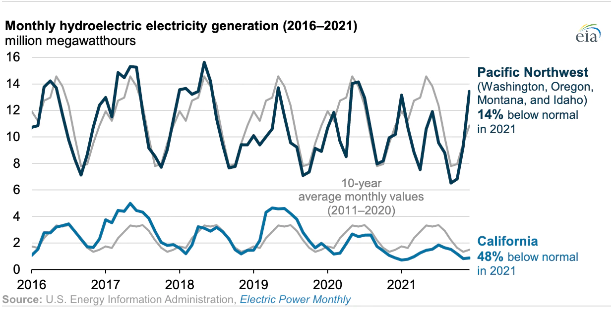
In kinda related news, the federal Energy Information Administration published figures on the effects of last year’s drought on hydropower generation. As expected it was kind of grim, with California facilities only producing about half of what they normally would.
But it’s okay, right? I mean that was last year and now the drought’s over, so … Huh? What’s that? Oh. Oh, dear. This just in: Snowpack levels in the Sierras are between 30 percent and 44 percent of average for this date. Unless the storms come quick and bountiful, it’s going to be another year of diminished hydropower in the Golden State. Not good.
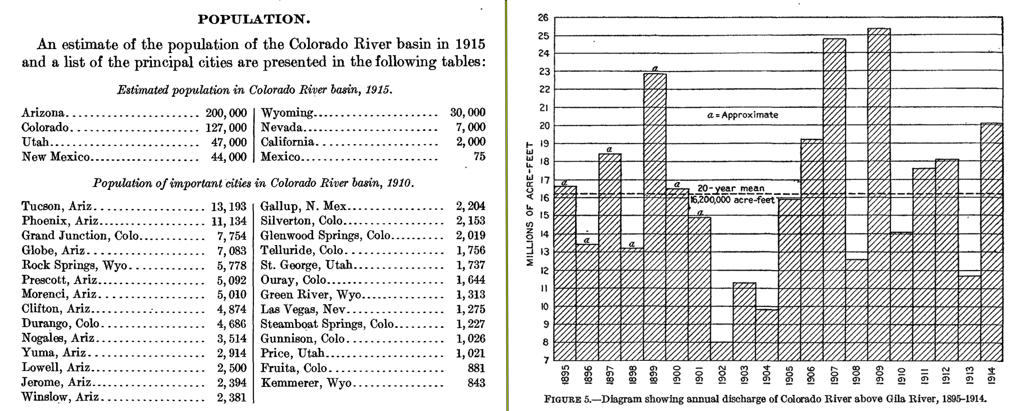
We promised we’d be doing various Colorado River Compact-related coverage this year, so here are a couple pretty fascinating tidbits I found in a 1916 USGS paper on the Colorado River. On the left are population figures for major towns and cities in the Colorado Basin and for the portion of states lying within the Basin. On the right are annual streamflows for the Colorado River above its confluence with the Gila. Turns out the average for that time period was a bit higher than the historic mean, leading Compact negotiators to parcel out more water than actually existed in the river. Whoops!
Population and streamflow at the time the Colorado River Compact was being negotiated. Credit: The Land Desk