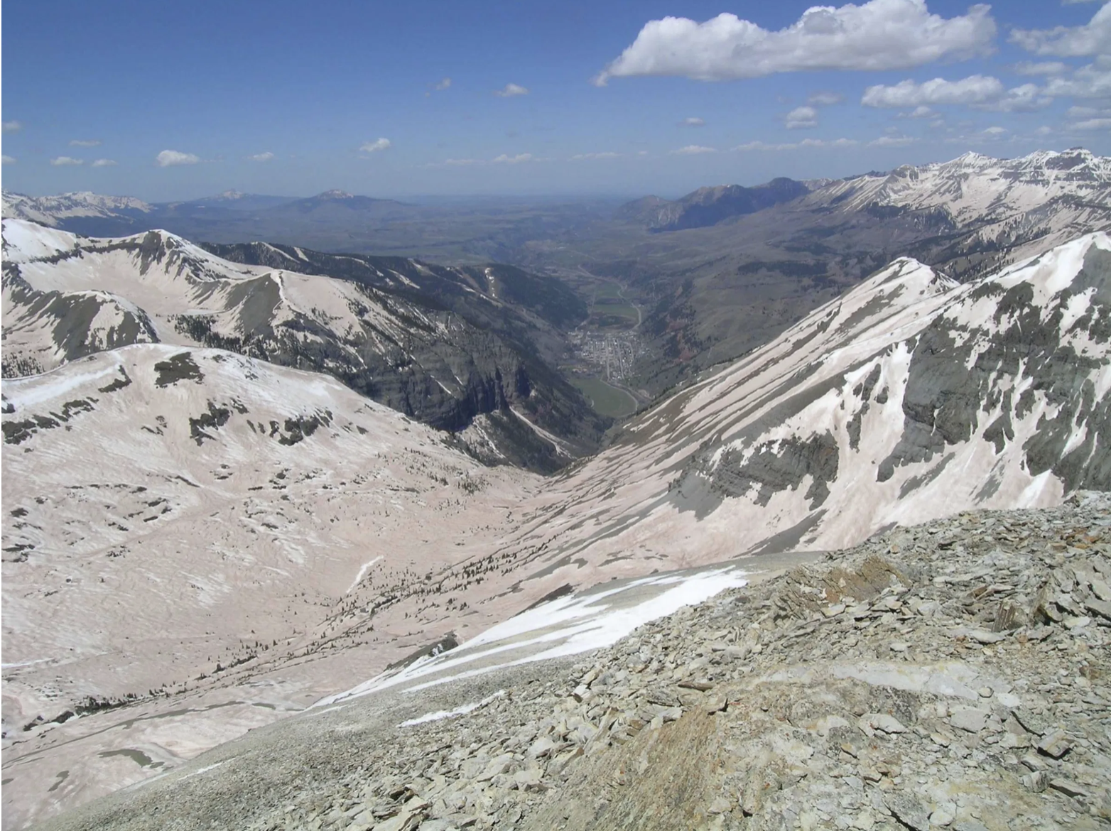
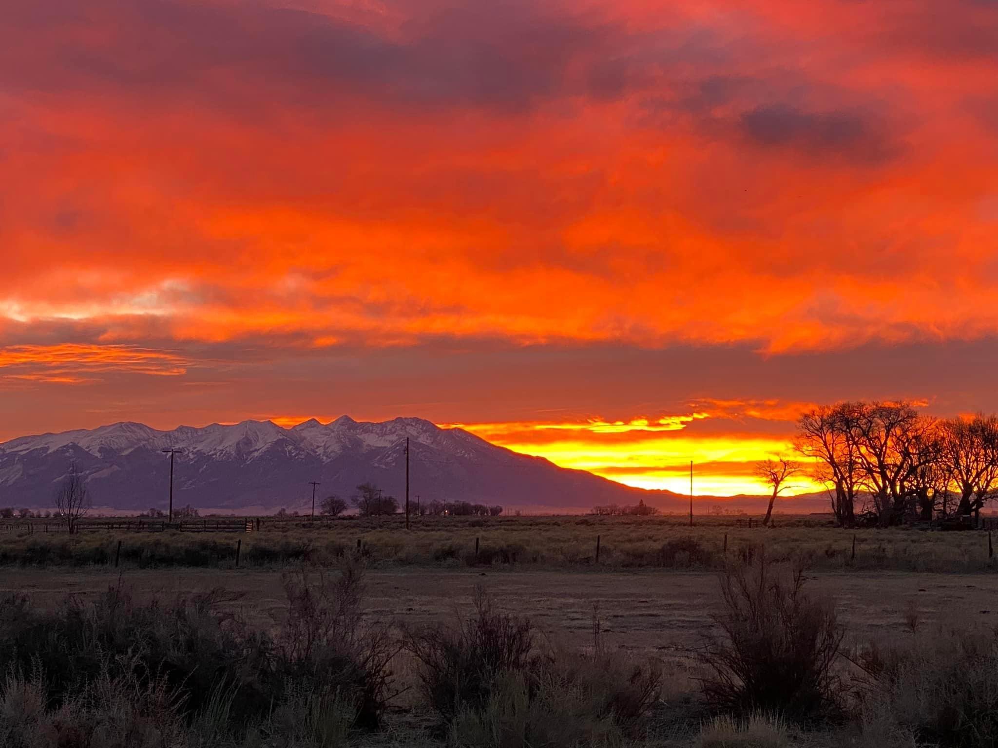
As warm spring winds whip the Eastern Plains, sapping soils of moisture, and the state’s reservoirs sit at below-average levels, water managers got more bad news Tuesday: this two-year drought cycle could continue through the summer and into the fall leading the state into its third year of below-average snowpack and streamflows and high wildfire danger.
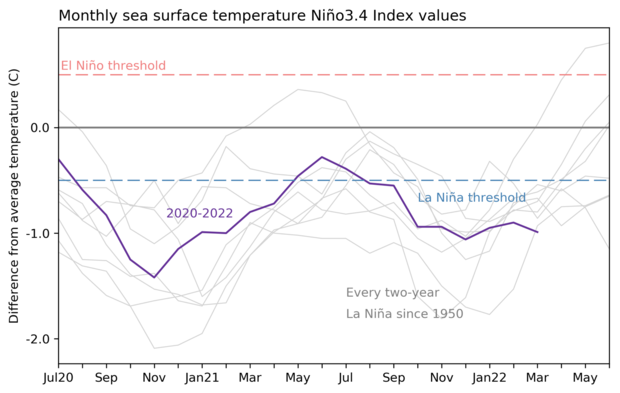
Looking ahead the weather pattern known as La Niña, which has created the intense drought of the past two years, is likely to continue, according to Peter Goble, a climate specialist with Colorado State University’s Colorado Climate Center.
“La Niña is not letting go,” Goble said Tuesday at a meeting of the state’s Water Availability Task Force, a group charged with monitoring the state’s water supplies. “It may stick around for a third year and this will reduce our chances of any meaningful drought recovery this spring and summer.”
In Colorado, and other Western states, mountain snow levels are closely watched because when they melt in late spring, they supply the majority of water for cities and farms.
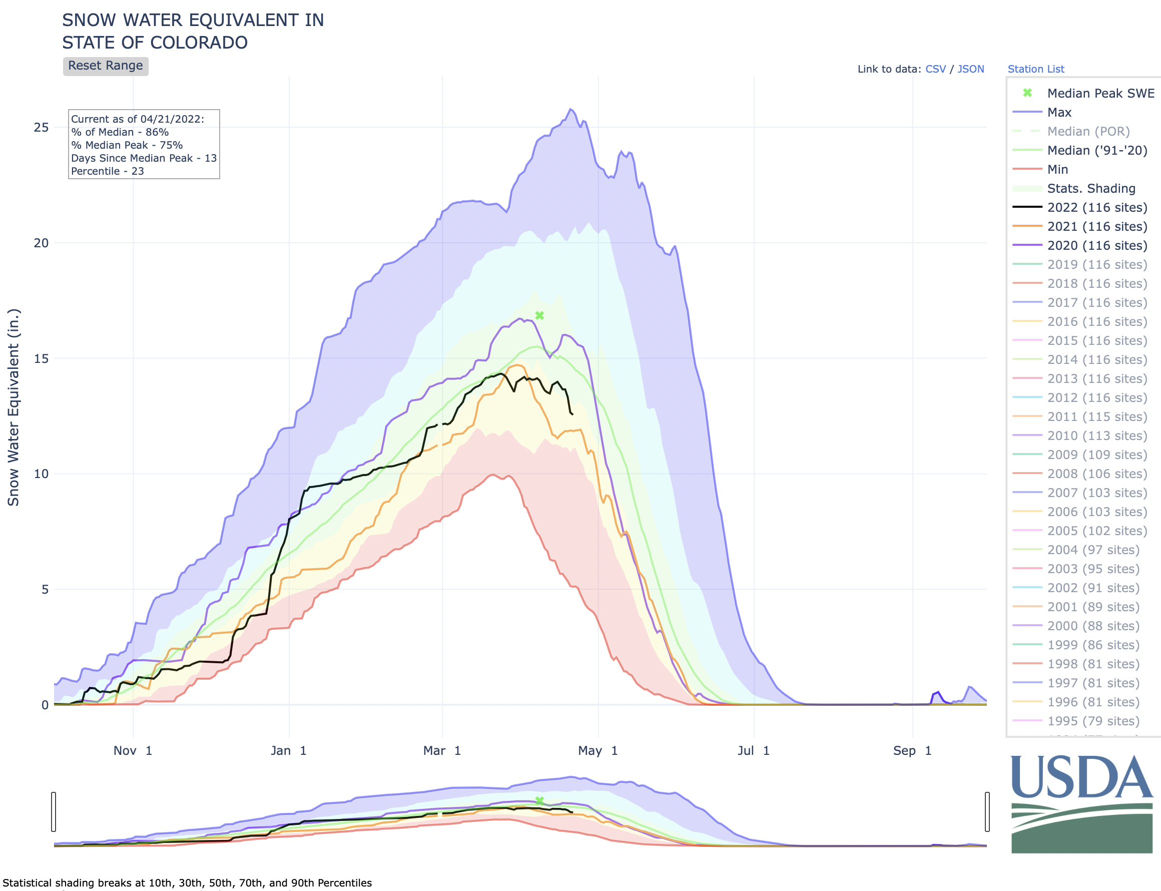
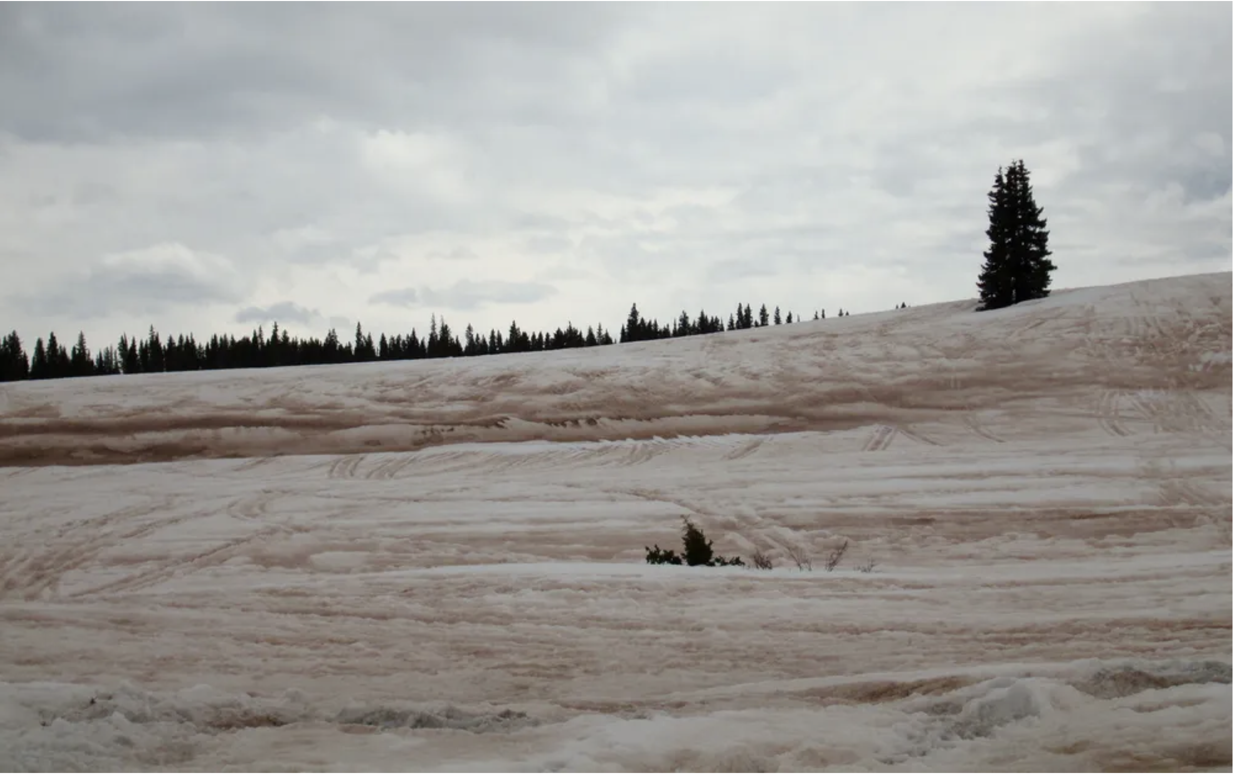
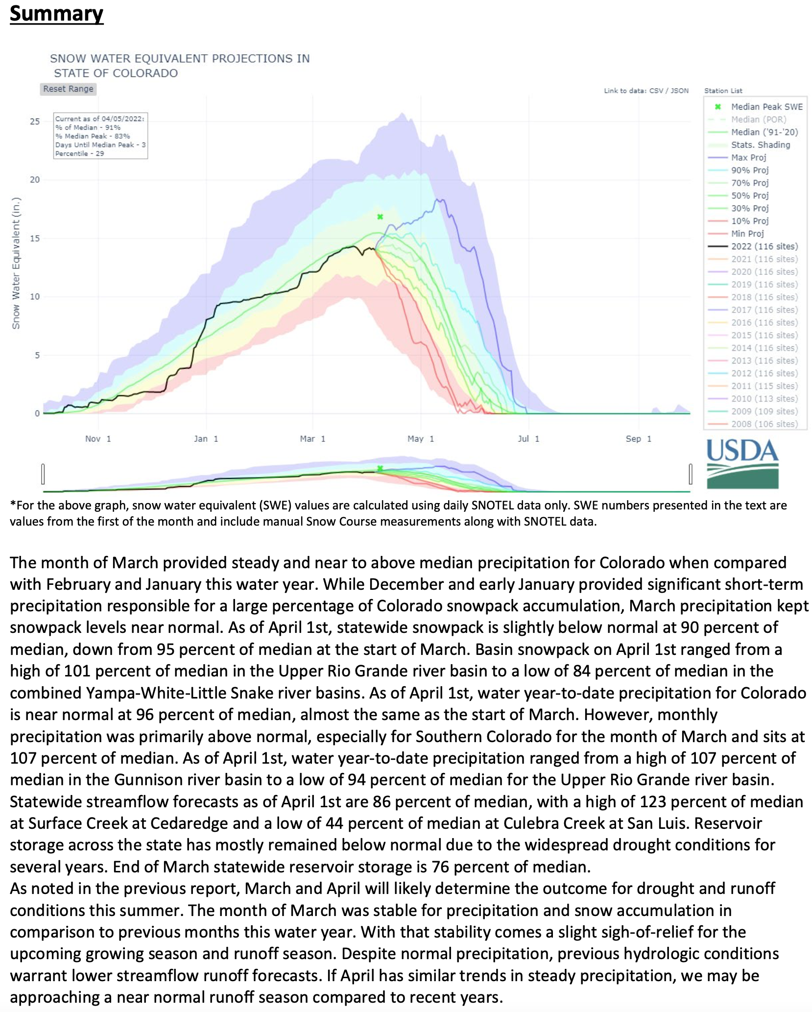
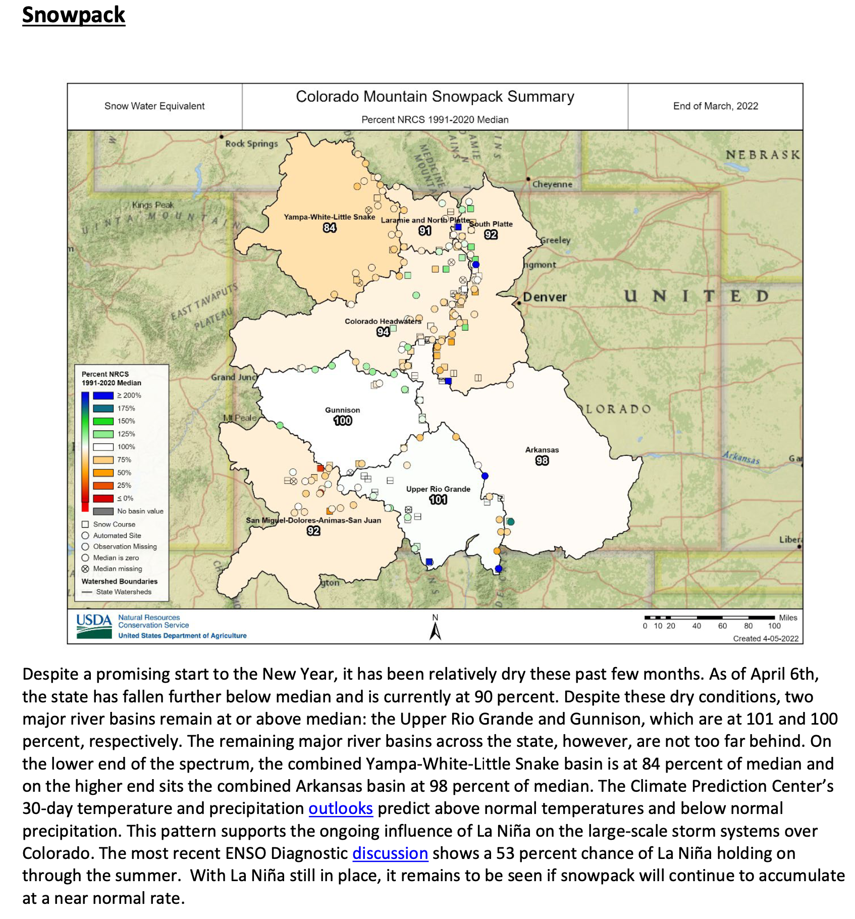
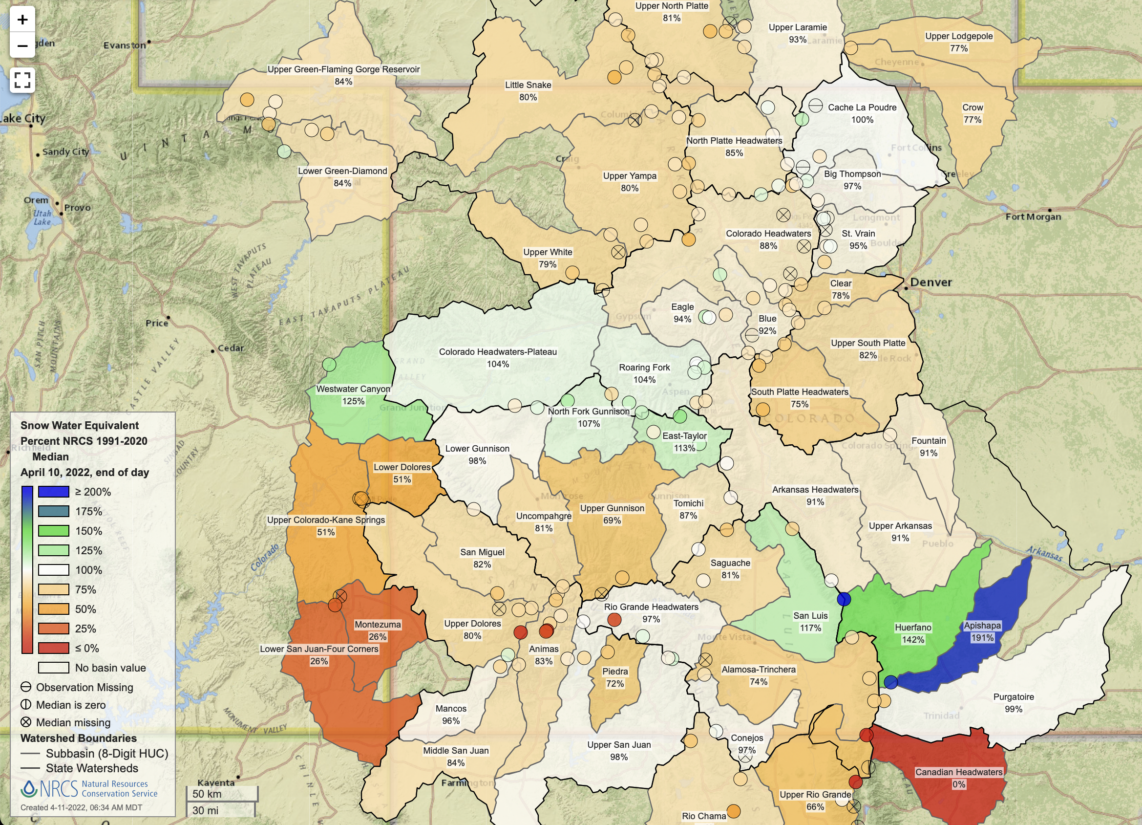
Now, statewide snowpack is at [86%] of average, according to the NRCS, an improvement over last year’s 79% of average mark at this time. But ultra-windy conditions and warm temperatures continue to rob the soils statewide of critical moisture, meaning a significant amount of the water from melting snow will be absorbed before it reaches streams.
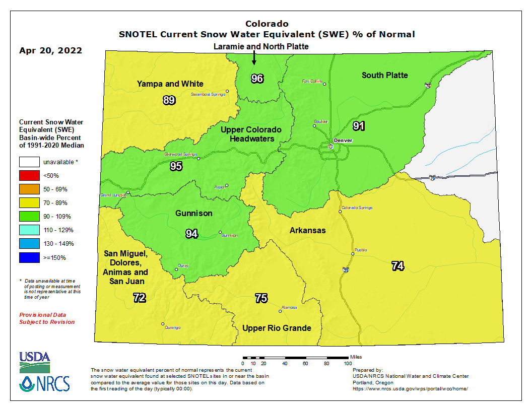
Colorado snowpack basin-filled map April 20, 2022 via the NRCS.
At the same time the state’s stored water supplies are at just 76% of normal, according to Karl Wetlaufer, a hydrologist and assistant snow survey supervisor with the NRCS.
“We’re seeing some of the lowest storage levels in more than 30 years,” Wetlaufer said.
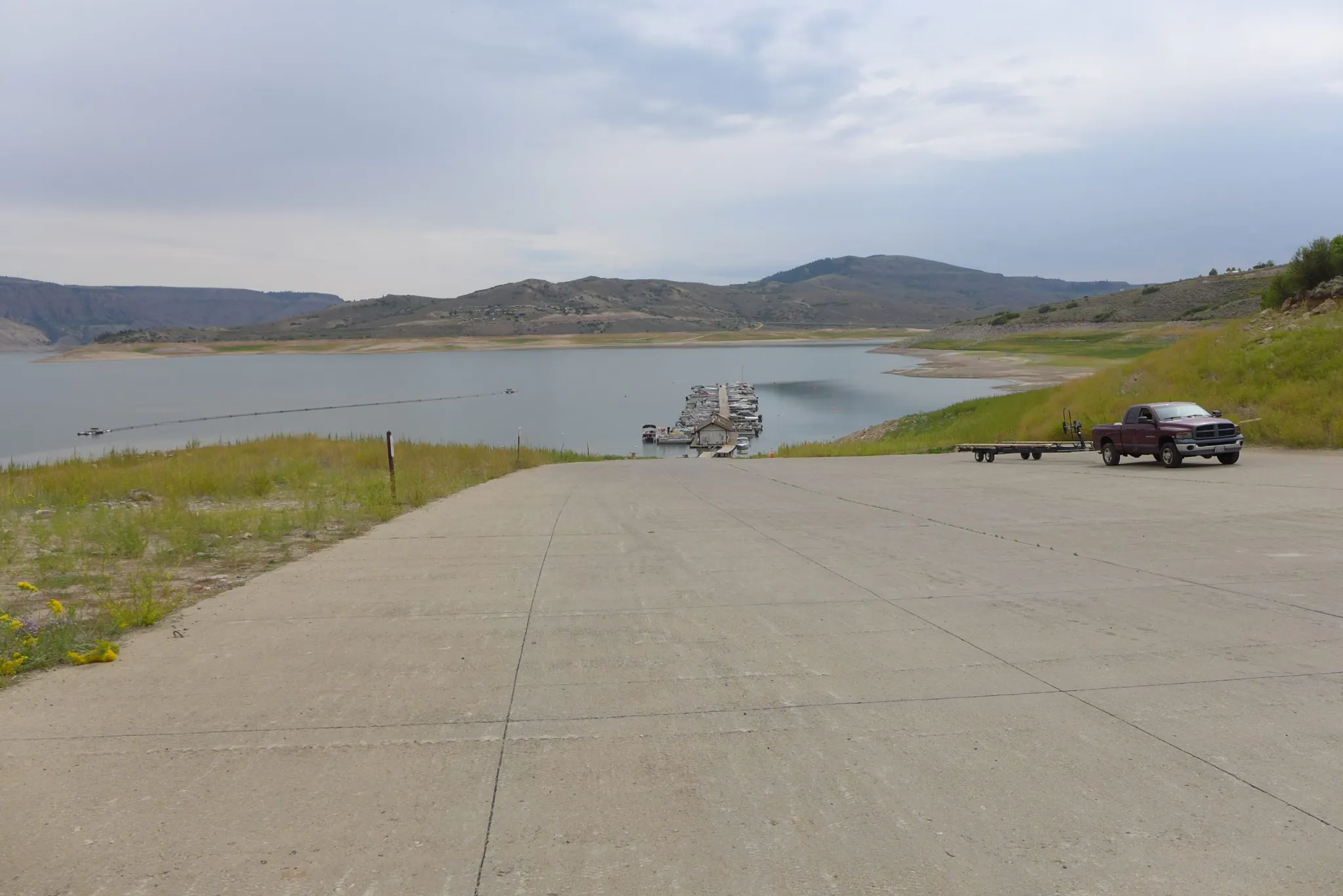
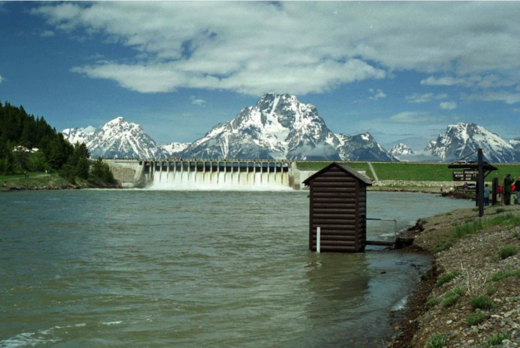
Blue Mesa Reservoir is Colorado’s largest reservoir, able to store some 800,000 acre-feet of water. But due to the drought, and an emergency release of 36,000 acre-feet last summer to aid Lake Powell, Blue Mesa is just over 40% full.
More releases to Lake Powell from the reservoir, a recreational hot spot, may be necessary this summer. And because runoff isn’t expected to be that high, Blue Mesa isn’t expected to recover much, if at all this year, officials said.
The boat ramp at the Lake Fork Marina closed for the season on Sept. 2 due to declining reservoir levels. The Bureau of Reclamation is making emergency releases out of Blue Mesa Reservoir to prop up levels in Lake Powell and preserve the ability to make hydropower. CREDIT: HEATHER SACKETT/ASPEN JOURNALISM
“Blue Mesa is not expected to fill, and by the end of this year it will be right back to where it is now … it’s not looking good for this area,” said Beverly Richards, a water resources specialist with the Upper Gunnison River Water Conservancy District, which helps shape policy and management strategies for the river.
More releases to Lake Powell from the reservoir, a recreational hot spot, may be necessary this summer. And because runoff isn’t expected to be that high, Blue Mesa isn’t expected to recover much, if at all this year, officials said.
“Blue Mesa is not expected to fill, and by the end of this year it will be right back to where it is now … it’s not looking good for this area,” said Beverly Richards, a water resources specialist with the Upper Gunnison River Water Conservancy District, which helps shape policy and management strategies for the river.
On the Front Range, some cities, such as Thornton, expect their reservoirs to fill. The South Platte Basin is near normal for its snowpack and streamflow forecasts are healthier than others across the state.
But Swithin Dick, water resources manager for Centennial Water and Sanitation District in Highlands Ranch, said the outlook is worrisome.
“My gut meter is moving from cautious to concerned,” Dick said.
Denver Water, Colorado’s largest city water supplier, derives its supplies from the Upper Colorado River Basin on the West Slope, as well as the South Platte River. Its storage system is at 79% full, while snowpack in its mountain watersheds is measuring 79% to 80% full.
Some relief from the dry, windy weather could come in May if forecasts prove to be off track, Goble said.
“You want some million dollar rains on the Eastern Plains,“ Goble said. “But the deck is stacked against us.”
Jerd Smith is editor of Fresh Water News. She can be reached at 720-398-6474, via email at jerd@wateredco.org or @jerd_smith.
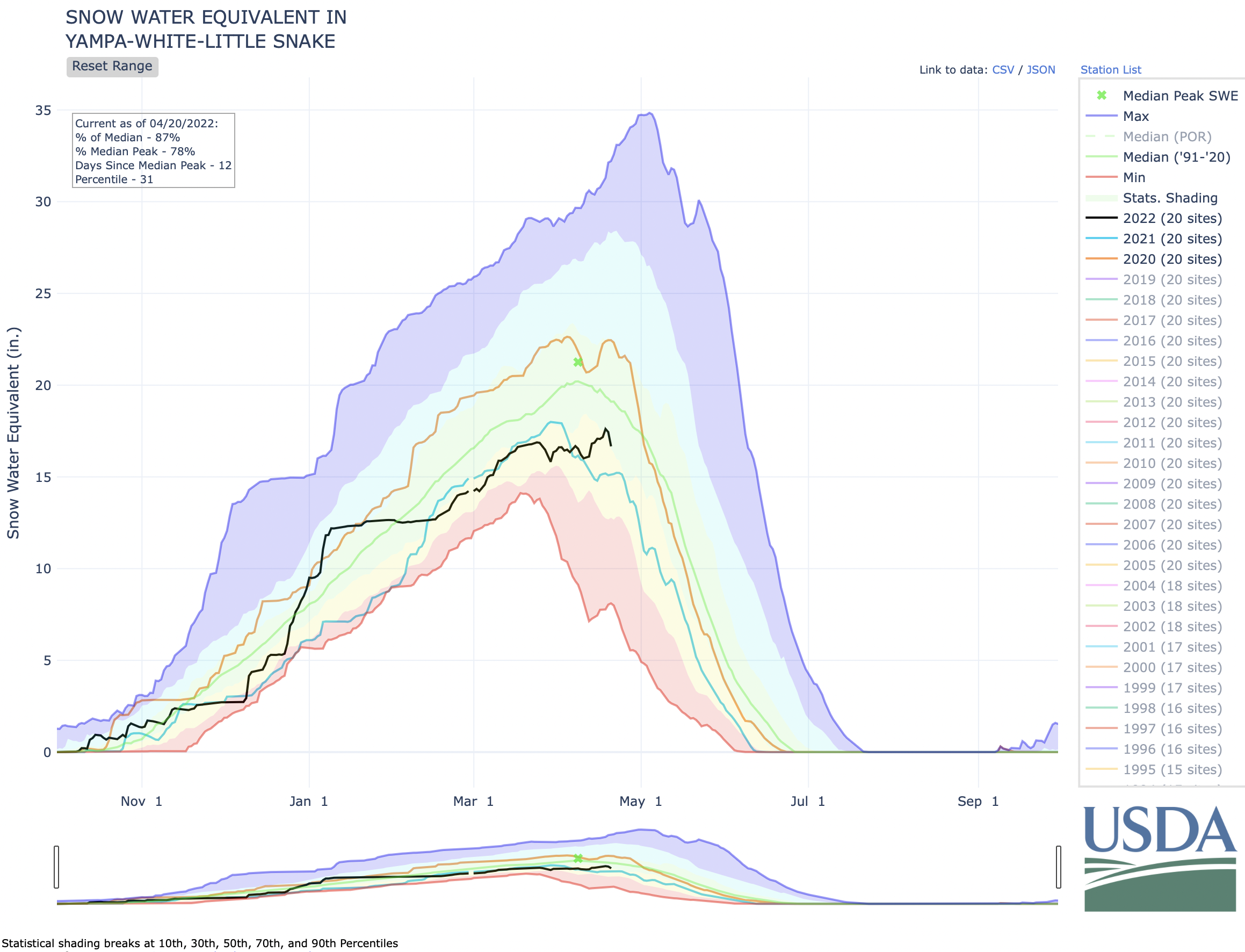
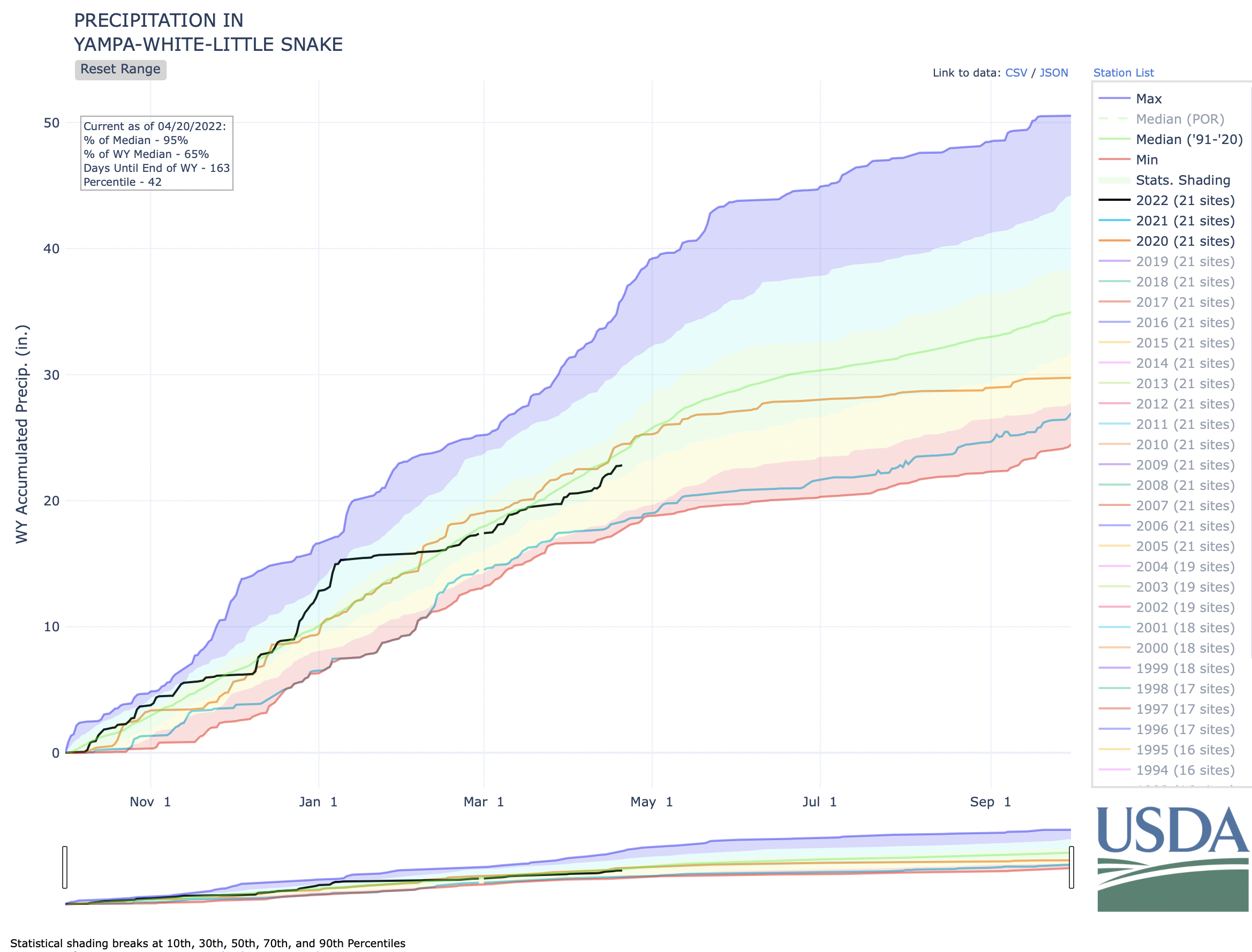
Precipitation in the last week has increased the amount of water in the Yampa, White and Little Snake River Basin’s snowpack, pushing it past the potential peak in late March. If that March 25 peak had held, it would have been the earliest since 2017, but nearly an inch of rain in April means the peak could come at the latest date it has since 2013.
“This week was like a godsend,” said Todd Hagenbuch, director and agricultural agent for the Routt County Colorado State University Extension Office. “I’m not going to say I’m overly optimistic now, but it was certainly better than a poke in the eye with a sharp stick.”
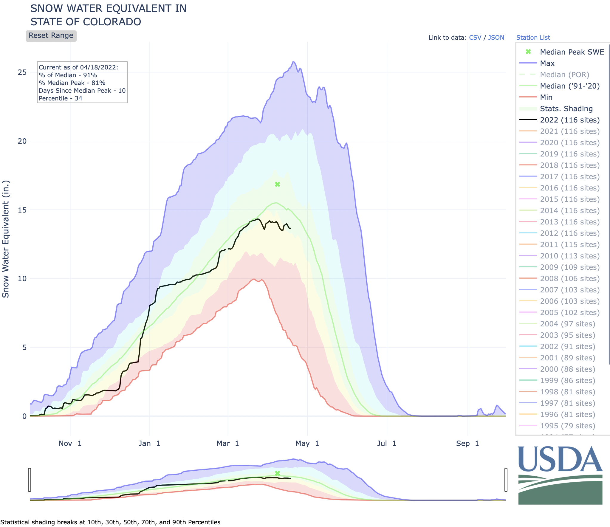
The snow-water equivalent of the area’s snowpack stood at 17.6 inches on Monday, April 18, according to the National Water and Climate Center. More moisture is always a good thing, according to Hagenbuch, who said the situation is not as dire now as it seemed each of the last two springs.
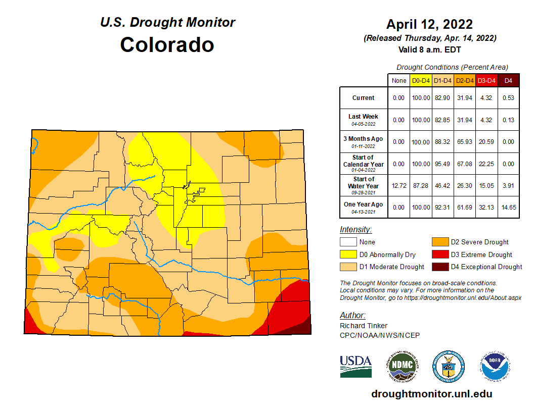
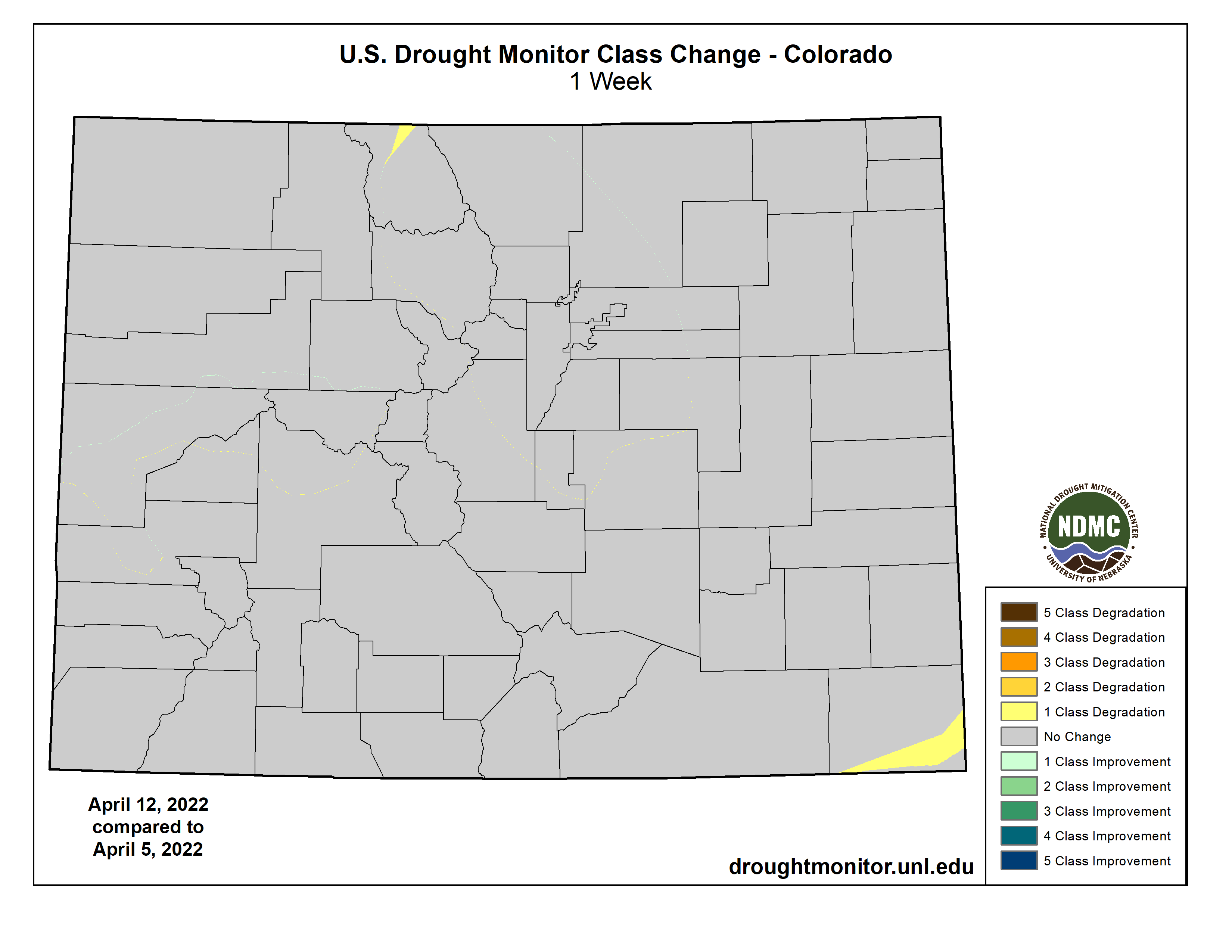
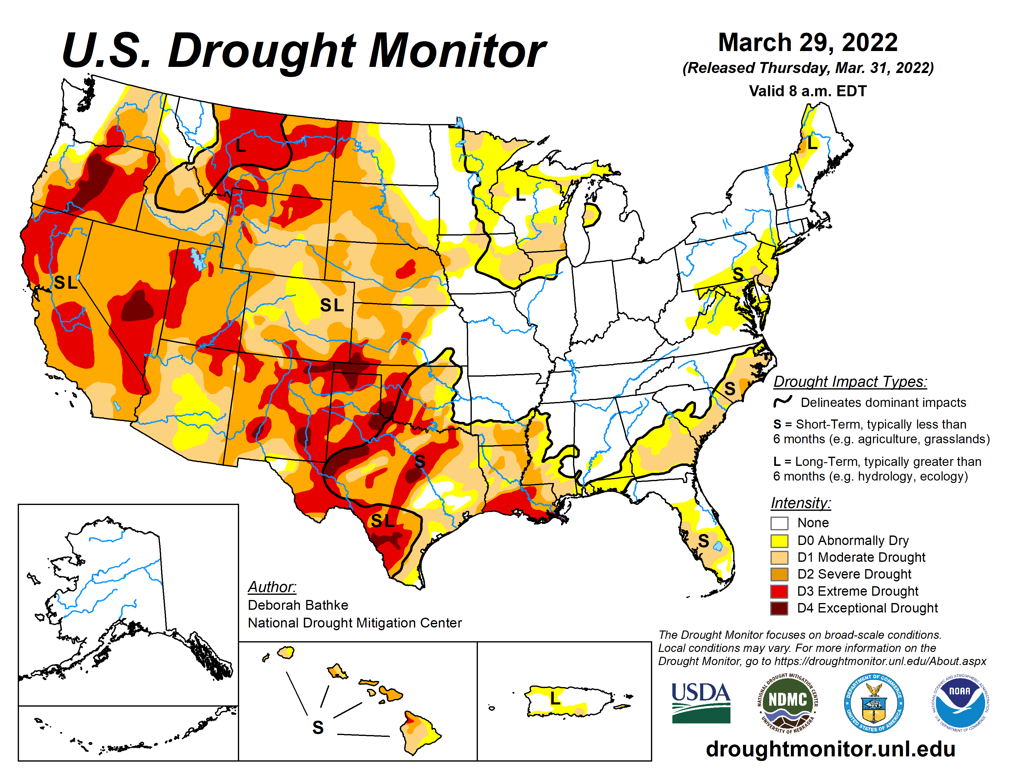
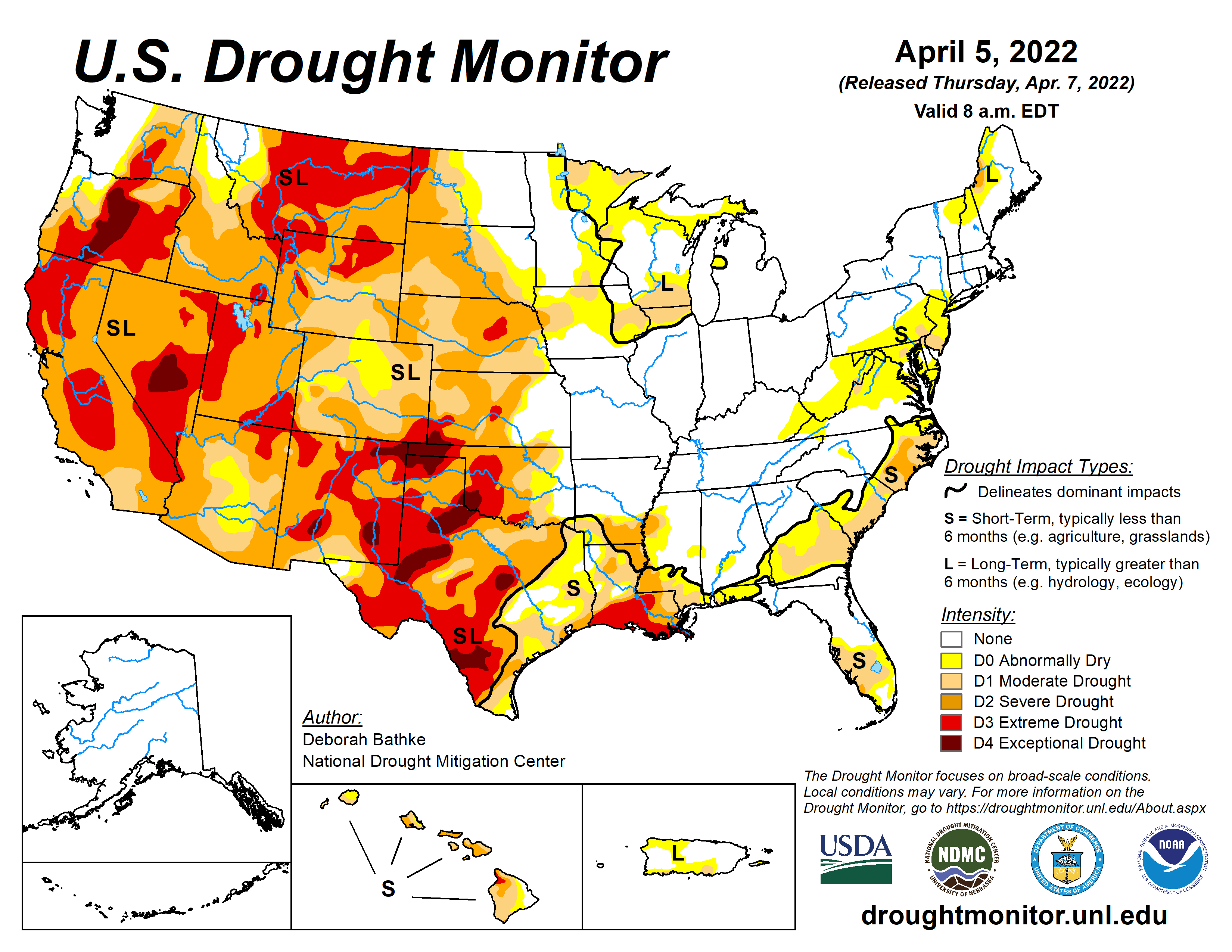
Colorado Drought Monitor map April 12, 2022.
This time last year, the U.S. Drought Monitor considered Routt County to be in extreme and exceptional drought. The latest map is less severe with the entire county considered to have moderate drought conditions.
While the snowpack is looking better, it is still at a lower level than last year’s peak of 18 inches of water, and well below the 30-year median peak of 21.3 inches for the basin. Water officials at the Colorado River District’s State of the Yampa River event last month said spring rain would be key to how this water year ends up. So far, precipitation has been near normal for April, and there is more in the forecast for later in the week.
Click the link to read the article on The Denver Post website (Aldo Svali). Here’s an excerpt:
Colorado over the past 20 years has suffered more major natural disasters than Florida and is among nine states where the number of events causing $1 billion or more in damage has more than tripled over the past 40 years, according to a new study from QuoteWizard, an insurance policy search engine. Between 1982 and 2001, Colorado recorded a dozen major natural disasters, but in the two decades that followed, it recorded 45, an increase of 275%. Only Kansas, despite its much smaller population and economy, had a bigger gain at 288%, going from 16 to 62 major disasters.
“Natural disasters of this magnitude used to happen infrequently in Colorado – about one every other year. Now, they are happening twice a year (on average),” said Nick VinZant, an analyst with QuoteWizard in an email.
A larger population spread across larger swaths of the state, not to mention more expensive cars, homes and infrastructure to replace when things go wrong only offer a partial explanation. The blame mostly comes down to much more unstable weather patterns.
“Climate change is the main reason why Colorado has seen such a significant increase in major natural disasters. Storms are more severe, the wildfire season is longer and drought has become more common,” VinZant said.
Hail Wheat Ridge May 8, 2015. Photo credit TreeRootCO.
Ranking and time evolution of summer (June–August) drought severity as indicated by negative 0–200 cm soil moisture anomalies. Maps show how gridded summer drought severity in each year from 2000–2021 ranked among all years 1901–2021, where low (brown) means low soil moisture and therefore high drought severity. Yellow boxes bound the southwestern North America (SWNA) study region. Time series shows standardized anomalies (σ) of the SWNA regionally averaged soil moisture record relative to a 1950–1999 baseline. Black time series shows annual values and the red time series shows the 22-year running mean, with values displayed on the final year of each 22-year window. Geographic boundaries in maps were accessed through Matlab 2020a.
Fourteen droughts have devastated the livelihood of farmers, ranchers and tourism attractions over prolonged stretches. By contrast, the 11 major wildfires wreaked their misery over a few days or hours in the case of the Marshall fire on December 30. Fueled by winds topping 100 mph, the grass fire destroyed 1,084 homes worth more than $500 million to become the most damaging in state history in terms of structures destroyed.
September 2013 flooding via AWRA Colorado Section Symposium
Governor Clarence J. Morley signing Colorado River compact and South Platte River compact bills, Delph Carpenter standing center. Unidentified photographer. Date 1925. Print from Denver Post. From the CSU Water Archives
Click the link to read the article on the Progressive Farmer website (Chris Clayton). Here’s an excerpt:
[Governor Pete] Ricketts signed legislation authorizing a $500 million canal meant to counter what Nebraska sees as attempts in Colorado to potentially hold back future water flows on the South Platte River. Nebraska will invoke a nearly 100-year-old clause in a water compact between the two states to dig out what is commonly called the Perkins County Canal. Nebraska lawmakers last week passed the bill, LB 1015, to back the canal project despite some concerns about its costs and possible legal battles ahead.
“Today, we enacted two key laws to strengthen Nebraska’s water resources,” Ricketts said in signing the bill. “LB 1015 helps protect the South Platte River water we depend on for drinking water, agricultural irrigation, and to nourish our natural environment.”
Ricketts also signed a separate bill, LB 1023, that will create a 3,600-acre lake in eastern Nebraska, as well as fund some other recreational projects.
Ricketts began championing the Perkins County Canal early in the year, cautioning against plans for water projects in Colorado totaling nearly $10 billion. Ricketts told lawmakers at a hearing in February, “Colorado is looking to take our water.” Ricketts said the canal is also a “hedge against drought” in western Nebraska as well.
Nebraska has a compact with Colorado that guarantees the state of Nebraska minimum flows of South Platte River water throughout the year…
Kent Miller, general manger of the Twin Platte Natural Resources District out of North Platte, Neb., told DTN he’s been urging Nebraska leaders for the last 25 years to invoke a clause in the South Platt River Compact to build the canal…
Nebraska officials said Monday it would likely take close to a decade before the Perkins County Canal can be built.
Click the link to read about America’s Most Endangered Rivers 2022 on the American Rivers website. Here’s an excerpt:
It is time to do more than plan. We must implement strategies that allow the Colorado River to thrive in the face of climate change. Failure is not an option.
The Colorado River provides drinking water for 40 million people, irrigates five million acres of farm and ranch land, and supports a $1.4 trillion economy. All of this is at risk due to rising temperatures and drought driven by climate change, combined with outdated river management and overallocation of limited water supplies. River flows are at historic lows and the levels of Lake Powell and Lake Mead reservoirs are dropping precipitously. With the passage of the Infrastructure Investment and Jobs Act, the seven basin states and the Biden administration now have a critical opportunity to implement proven, equitable solutions that enhance water security and river health, while building resilience to future climate change. Failure is simply not an option, given all that depends on a healthy, flowing Colorado River.
American Rivers appreciates the collaboration and efforts of our partners:
National Audubon Society
Environmental Defense Fund
Western Resource Advocates
Theodore Roosevelt Conservation Partnership
Water for Arizona
Water for Colorado
Raise the River
Business for Water Stewardship
Colorado River “Beginnings”. Photo: Brent Gardner-Smith/Aspen Journalism
Click the link to read “America’s Most Endangered Rivers of 2022 Spotlights Rivers in Crisis Mode” on the American Rivers website (Jessie Thomas-Blate):
Today [April 18, 2022] we are announcing America’s Most Endangered Rivers® of 2022 and sounding the alarm that our nation’s rivers and clean water are in crisis.
Catastrophic drought. Disastrous floods. Fish and other freshwater species nearing extinction, as rivers heat up.
Many people in the United States have imagined climate change as a problem in the future. But it is here now, and the primary way that each of us is experiencing climate change is through water. The climate crisis is a water crisis.
Today we are announcing America’s Most Endangered Rivers® of 2022 and sounding the alarm that our nation’s rivers and clean water are in crisis. Topping the list this year is the Colorado River, which is threatened by climate change and outdated water management. Thirty federally-recognized Tribal Nations, seven states, Mexico and 40 million people who rely on the river for drinking water are being impacted by this crisis. Also threatened is vital habitat for wildlife, as the Basin is home to 30 native fish species, two-thirds of which are threatened or endangered, and more than 400 bird species.
Lake Powell just north of Glen Canyon Dam. January 2022. Jonathan P. Thompson photo.
In March 2022, water levels at Lake Powell (the impoundment created by Glen Canyon Dam in Utah/Arizona) fell to the lowest point since the lake first filled in 1980. The Colorado River system is already operating at a deficit, and climate change is expected to further reduce the river’s flow by 10 to 30 percent by 2050. We’re calling on the Biden administration and the seven Basin states to work together to allocate funds from the Infrastructure Investment and Jobs Act to implement proven, equitable solutions that prioritize river health and water security.
Our country’s rivers need attention now. We must work better. Smarter. More equitably. We must elevate Tribal Nations and learn from their Traditional Ecological Knowledge. We must work collaboratively with frontline communities along the Mississippi River, and in places like the Mobile River (AL) and Tar Creek (OK), where residents deal with pollution on a regular basis. We must heed the calls of Tribal Nations to restore rivers like the Snake River.
California makes a prominent appearance in the report this year as well. In addition to the Colorado River (a key source of drinking water for some California residents), also featured are the Los Angeles River (threatened by inadequate management, climate change and pollution) and the Lower Kern River (threatened by excessive water withdrawals).
No matter where you live in the United States, your river and your drinking water are affected by climate change. Black, Indigenous, Latino/a/x and other communities of color feel these impacts most acutely, due to historical and contemporary policies, practices and norms that maintain inequities. It’s time to follow the lead of frontline communities that are advancing solutions for rivers and clean water — solutions that will make us all safer and healthier, and our nation stronger.
Did you know that later this year is the 50th anniversary of the passage of the Clean Water Act? How can it be that are we still battling over the importance of clean water? This battle comes to the ground on Arizona’s San Pedro River where rollbacks to the Clean Water Act initiated during the Trump administration have removed protections for seasonal and intermittent streams, which encompass almost 94 percent of the San Pedro River’s waterways and provide the lifeblood that sustains the river. We must protect the Waters of the U.S. now, before it is too late.
Rounding out this year’s report are Alabama’s Coosa River, which is threatened by pollution from industrial poultry farming, and Maine’s Atlantic Salmon Rivers, where we have an opportunity to save Atlantic salmon by making better decisions during the upcoming relicensing of hydropower dams.
All of these rivers face critical decisions this year, and you can do something to help. Go check out your favorite river from this report and TAKE ACTION TODAY!
If we are to meet this moment and confront the challenges facing our clean water, environment and communities, we must come together as a powerful movement, speaking up for the rivers that give us life — for these 10 endangered rivers, and all of the rivers essential to our shared future.
America’s Most Endangered Rivers® of 2022
Colorado River in Grand Junction. Photo credit: Allen Best
#1 Colorado River
State: CO, UT, AZ, NV, CA, WY, NM, Mexico
Threat: Climate change, outdated water management
The Snake River, Jackson Lake Dam and the Teton Range. 1997 photo/Wikipedia
#2 Snake River
State: ID, WA, OR
Threat: Four federal dams
The Mobile River, taken from the site of the former Fort Stoddert near Mount Vernon, Alabama. Date: 21 March 2009. Source: Own work Author: Altairisfar
#3 Mobile River
State: AL
Threat: Coal ash contamination
Evening on the Sheepscot River. Walking along the river in Wiscasset. Weekend trip to Maine for a friend’s wedding, October 2009. By Tim Sackton – Flickr: Evening on the Sheepscot River, CC BY-SA 2.0, https://commons.wikimedia.org/w/index.php?curid=12883043
Threat: Excessive water pumping; loss of Clean Water Act protections
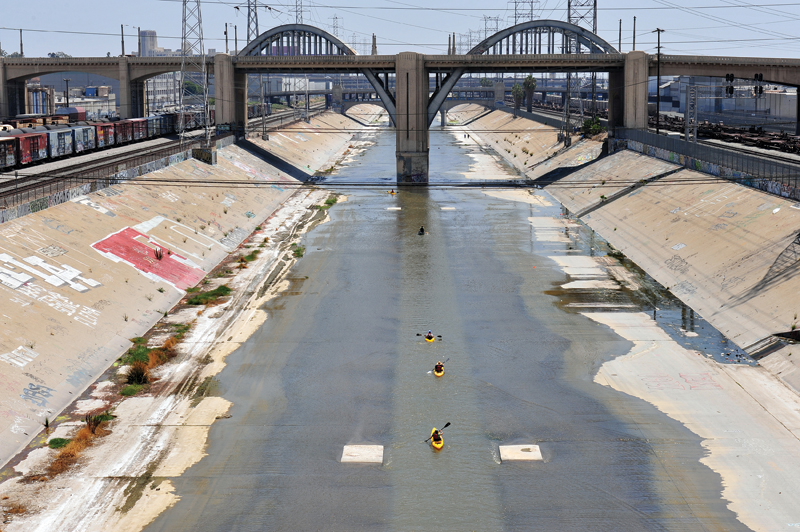
Kayakers float the Los Angeles River near the Sixth Street Bridge in downtown L.A. Photo credit Tom Andrews via The High Country News.
#9 Los Angeles River
State: CA
Threat: Development, pollution
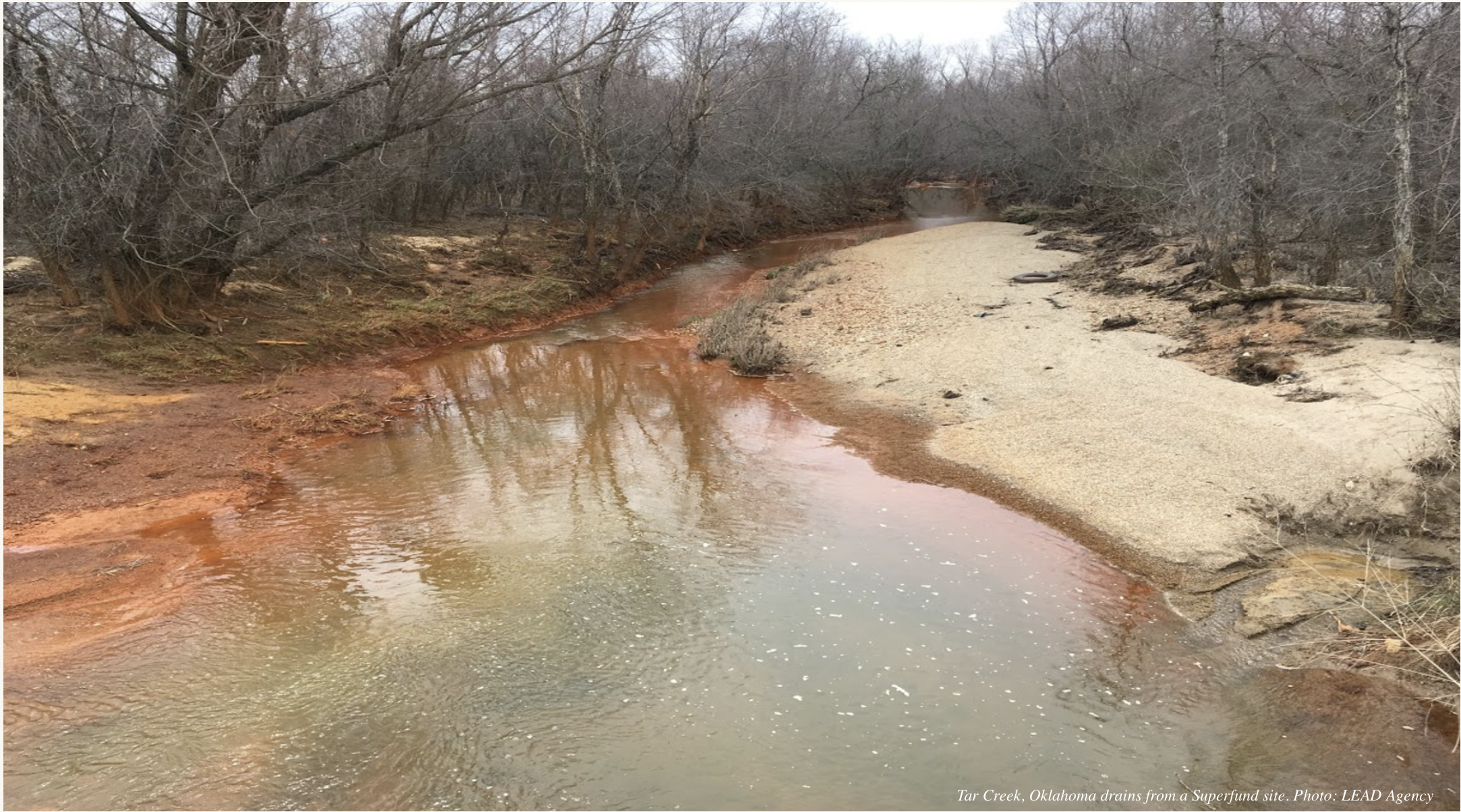
Tar Creek, Oklahoma drains from a Superfund site. Photo: LEAD Agency
#10 Tar Creek
State: OK
Threat: Pollution
Restoration work along the Colorado River reestablished a riverbank more conducive to irrigation access. (Source: Paul Bruchez)
Click the link to read “Colorado River named most endangered waterway in US” on the OutThereColorado.com website (Carol McKinley). Here’s an excerpt:
The Colorado River Basin is home to 30 native fish species, many of which are threatened. More than 400 bird species depend on the area as well. The 1,450-mile river provides water for Denver, Los Angeles, Phoenix and Las Vegas. Unlike Colorado’s other rivers, it touches all four corners of the state.
Rancher Paul Bruchez, his dad and his brother moved their families from Westminster to Kremmling in 2000 with a dream of ranching in the mountains. They bought the 6,000-acre Reeder Creek Ranch in part because the Colorado River runs through it. For a couple of glorious years, all was flowing according to plan: The Rocky Mountain snowpack fed the river, the fish were thriving and the crops grew tall. But when the drought of 2002 hit, the snowmelt was around half of where it was supposed to be and warm temperatures made things worse, quickening the thaw so that runoff didn’t last very long. That year, Bruchez could walk across the river in places and see the fish going belly up in the warm water.
“Come 2003, my family had a meeting. We wondered, did we move to the wrong place? Instead of leaving, we decided to adapt and adjust to the river flow, climate change and population growth,” Bruchez told The Denver Gazette.
Seeing no quick fix, Bruchez established a restoration project and a Colorado Basin roundtable and prepared to go along for the ride. Over time, Bruchez’s projects have led to water savings and recovery.
Lake Powell, just upstream from Glen Canyon Dam. At the time of this photo, in May 2021, Lake Powell was 34% full. (Ted Wood/The Water Desk)
Click the link to read “Advocacy group asks Southwest to ‘amp up the urgency’ on protecting Colorado River water” on the AZCentral.com website (Brandon Loomis). Here’s an excerpt:
“The urgency is extreme,” American Rivers spokesman Sinjin Eberle said, noting that the river serves some 40 million people and production of most of the nation’s winter vegetables. “We have to do something now.”
[…]
This year’s projection is not good. On the heels of two low-flow springs, the Colorado Basin River Forecast Center this month said current snowpack ready to melt suggests just 64% of normal flows will reach Lake Powell this season: 4.1 million acre-feet…
Brad Udall: Here’s the latest version of my 4-Panel plot thru Water Year (Oct-Sep) of 2021 of the Colorado River big reservoirs, natural flows, precipitation, and temperature. Data (PRISM) goes back or 1906 (or 1935 for reservoirs.) This updates previous work with @GreatLakesPeck.
“What we’re facing is the permanent warming and drying of the American Southwest,” Colorado State University water and climate scientist Brad Udall said in a statement. His research and outspoken warnings have suggested there’s little time to waste throttling back on water use when rising heat is causing plants and the atmosphere to sponge up springtime runoff before it ever reaches the river…
For its part, Arizona is working with neighbors to pay some users to keep water in Lake Mead over the next few years. These efforts follow a first-ever federal shortage declaration for 2022, which caused Arizona to forego water that otherwise would support Pinal County farms. In response those farmers have planted less and shifted to a declining groundwater supply.
The crisis is harming more than water suppliers’ outlooks. Lower reservoir levels are also limiting options for protecting the river’s own environment, especially in the Grand Canyon.
The prioritization of power generation at Glen Canyon Dam contributed to a decision by the U.S. Bureau of Reclamation not to release water to create an artificial flood to restore beaches and sandbars in Grand Canyon last fall, despite an abundance of rain-driven sand from last year’s monsoon season that had primed the river to deliver the desired results…
Flaming Gorge Reservoir July 2020. Photo credit: Utah DWR
Experiments with flushing water from Flaming Gorge Dam, upstream on the Green River, a Colorado River tributary, showed success in dislodging young bass from their protected nests and reducing numbers there, Bestgen told colleagues. A similar effort could make life hard for any bass that get established in Grand Canyon, but would further deplete Lake Powell’s storage.
The Green and Colorado rivers cut through Utah’s Canyonlands National Park. A warming climate is adding to the drought-driven declines in snowmelt and spring runoff across the Colorado River Basin. (Source: LightHawk Conservation Flying/The Water Desk)
Click the link to read “Colorado River named the most endangered in the U.S. by conservation group” on the Colorado Public Radio website (Michael Elizabeth Sakas). Here’s an excerpt:
The report highlighted how climate change and drought have affected the river but also faulted outdated water management practices for dwindling flows and low reservoir levels. Rice said the stakes are high, and more needs to be done to conserve the water that’s left. He said the basin states and the Biden administration must work urgently with the tribes and Mexico.
“We’ve made management decisions based on a river that hasn’t existed for a long time,” Rice said. “We have to use less water.”
American Rivers also released a list of strategies it recommends to adapt to a drier and warmer world. Rice wrote for the report that the scale and pace of climate-related changes in the Colorado River Basin “pose a gargantuan challenge, unprecedented in the history of water management.” Those strategies include changes to how federal infrastructure dollars are spent, like prioritizing forest management, restoring natural meadow systems to improve water retention and aquifer recharge and covering reservoirs and canals to reduce evaporation.
The report also details how drinking water across the U.S. is affected by climate change and notes how communities of color often feel these impacts most acutely because of “historical and contemporary policies, practices and norms that maintain inequities.” The report also urges water managers to follow the lead of tribal nations and frontline communities that are advancing solutions for rivers and clean water. Tribes in the Colorado River basin have long pushed for more inclusion in how the river is managed.
Colorado Riverfront Trail September 2019.
Click the link to read “Group lists Colorado River as most endangered” on the Grand Junction Daily Sentinel website (Dennis Webb). Here’s an excerpt:
The Colorado River, or portions of it, have made the list in years prior, but the river is being stressed as never before because of the level of demands on it and its diminishing water volumes, thanks to drought exacerbated by climate change. As American Rivers notes, the river is relied on by seven states, 30 federally recognized tribal nations and Mexico. It provides drinking water to 40 million people and vital habitat, including 30 native fish species and more than 400 types of birds. It also has been besieged by drought throughout this century, made worse by warmer conditions that further reduce snowpack runoff volumes…
Last summer, American Rivers and other conservation groups issued a list of 10 strategies to respond to climate change in the Colorado River Basin. These included things such as urban water conservation and reuse, shifting by farmers to crops requiring less water, improving land management practices to reduce the amount of dust that blows onto snowpack and accelerates snowmelt, prioritizing forest management and restoration, and upgrading agricultural infrastructure and operations. Rice also hopes to see increased efforts to restore headwaters, invest in watershed health, reconnect floodplains, ensure healthy riparian zones and restore rivers that have been diverted.
A recent data analysis by QuoteWizard.com, an insurance advice company with Lending Tree, has named Colorado a state with one of the largest increases of natural disasters over the last 40 years in the United States…
For a severe event to be considered a natural disaster, it has to cause serious disruptions within a community, according to the Federal Emergency Management Agency (FEMA)…
The analysis found that Colorado has the third highest increase in natural disasters in the country. Between 1982 and 2001, Colorado experienced 12 natural disasters, according to Quote Wizard. Whereas, there were 45 natural in the state between 2002 and 2021, a 275 percent increase. According to the analysis, the cost of natural disaster recovery in the state has been between $20 billion and $50 billion dollars, since 1981. Colorado natural disasters can include major droughts, flooding, freezes, winter storms, severe storms, and wildfires.
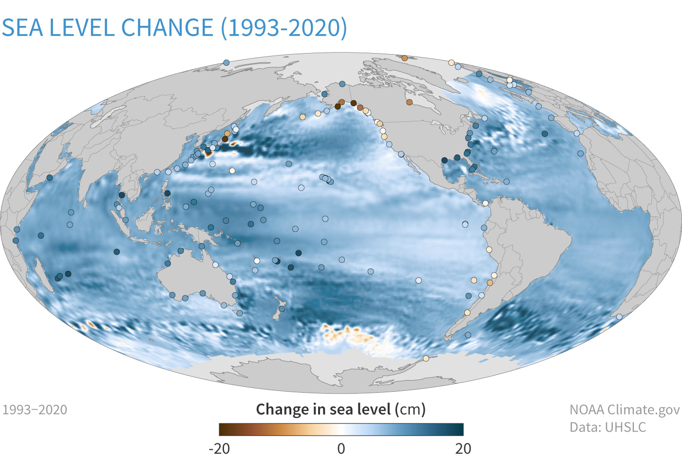
Change in sea level since the 1993. Blue indicates places where sea level has increased by up to 20 centimeters (8 inches); brown indicates places where sea level has dropped by the same amount. NOAA Climate.gov image, based on data from P. Thompson, UHSLC.
Click the link to read the article on the CBS News website. Here’s an excerpt:
If climate change were a disaster film, it would likely be accused of being too over-the-top: wildfires reducing entire towns to ashes, hurricanes swamping cities, droughts draining lakes and withering fields, and raging oceans redrawing the very maps of our coasts. And now, many cities and states are asking, who’s going to pay for all of this?
“This is real; we’re on the front line of climate change right here in Charleston,” said John Tecklenburg, the mayor of Charleston, South Carolina. The city’s been battered by an endless parade of floods due to sea level rise. Some desperate homeowners have resorted to raising their homes by several feet. So, the city is raising large parts of its existing sea wall, and the Army Corps of Engineers says Charleston should build another eight miles of wall. The city expects an estimated $3 billion in climate change-related costs…
Study after study has shown the companies’ carbon emissions from oil, coal and gas are major contributors to climate change. Charleston is one of more than two dozen cities, counties and states that are suing these companies (including ExxonMobil, Shell, Chevron, BP and ConocoPhillips)…
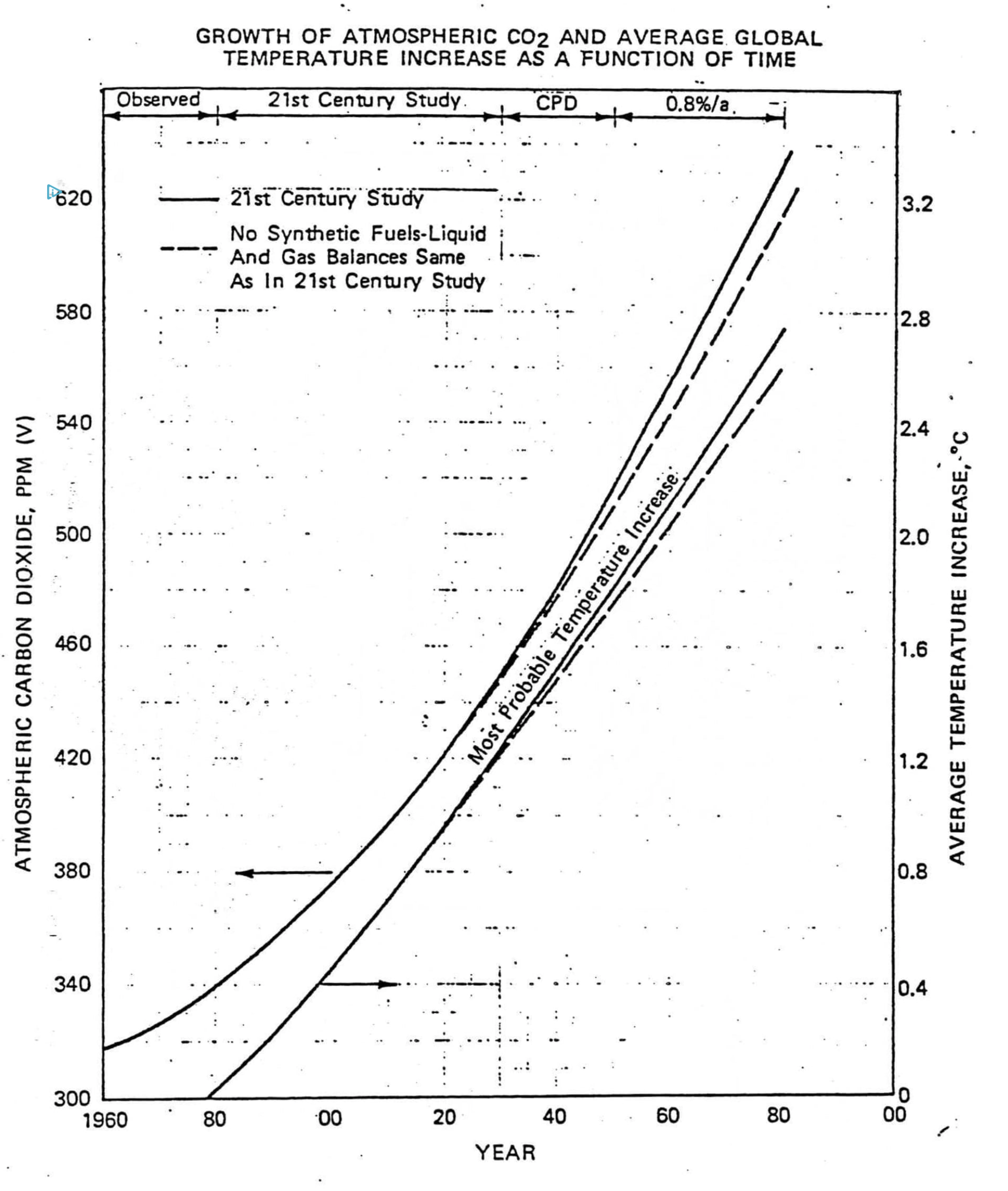
Exxon’s private prediction of the future growth of carbon dioxide levels (left axis) and global temperature relative to 1982 (right axis). Elsewhere in its report, Exxon noted that the most widely accepted science at the time indicated that doubling carbon dioxide levels would cause a global warming of 3°C. Illustration: 1982 Exxon internal briefing document
The suits are modeled after the “Big Tobacco” cases of the 1990s, and accuse the companies and industry groups of making false and misleading claims about climate change…
William Tong, attorney general of Connecticut, said, “I’m suing ExxonMobil because they lied to us.”
Tong is suing ExxonMobil under the state’s consumer protection laws. He said internal company research done by Exxon and Mobil (which used to be separate companies) shows they were aware of the dangers of climate change since at least the 1980s.
“There’s a study from, I think, 1982 in which they produce a chart that shows, as the levels of carbon dioxide rise, the temperature of our atmosphere will rise,” said Tong. “And that chart is almost exactly right.”
And the suit also cites a 1988 internal draft memo from an Exxon spokesperson advising the company “emphasize the uncertainty” of climate science…He points to ads that look like editorials from ExxonMobil, as well as their executives’ own words, including the 1996 statement by Lee Raymond (then the CEO of Exxon) that “the scientific evidence remains inconclusive as to whether human activities affect the global climate.”
Click the link to read the article on the Grist website (Joseph Lee). Here’s an excerpt:
Rights of Nature – an innovative legal movement that protects water, animals and ecosystems by giving them legal rights – might stop a pipeline.
In 2018, Frank Bibeau, an attorney for the White Earth Nation, helped the tribe write a law that recognized the rights of wild rice, which they call Manoomin, or “good berry”, to “exist, flourish, regenerate, and evolve.” The law relies on a section of an 1837 treaty between the Ojibwe and the U.S. government. In Minnesota, wild rice, and the waters it depends on, are in danger from climate change and the expansion of Line 3, a controversial pipeline operated by a Canadian energy company and fiercely opposed by Indigenous people and environmental activists. The pipeline’s proposed corridor would run directly through wild rice beds and could threaten the environmental health of the whole area. In 2021, he used the Rights of Manoomin law to sue the State of Minnesota over the construction of the pipeline.
“I couldn’t figure out how to get authority over them to compel them to do anything we might want to do. And right in my brain, you know, it just clicked,” Bibeau said. “Wild rice is mentioned specifically in the 1837 Treaty. It talks about how we retain the rights to hunt fish and gather wild rice on the lakes and rivers and lands that we’re ceding. Well, that’s huge.”
In a setback for the case in March, the White Earth Ojibwe Appellate Court dismissed the tribe’s own lawsuit. The ruling said that the court does not have jurisdiction over non-tribal member activities on off-reservation land. The case is still awaiting a decision from a Federal appeals court over that exact question.
Since Bibeau first developed Rights of Manoomin, other tribes have used it as a model. In 2019, the Yurok Tribe in Northern California adopted a resolution recognizing the rights of the Klamath River. In Seattle, the Sauk-Suiattle Indian Tribe is suing the city over its hydroelectric dams on behalf of salmon. Bibeau believes that these two cases will be the next step in the growing Indigenous Rights of Nature movement and have the potential to lead to widespread use by tribes across the country.
The western boundary of Senator Beck Basin is pictured May 12, 2009, after a dust event. That year was an exceptionally dusty one, with 12 dust events. The basin has experienced five dust events so far this year. CREDIT: COURTESY PHOTO BY THE CENTER FOR SNOW AND AVALANCHE STUDIES
Fort Lewis College students spent nearly 20 minutes digging a large snow pit until it was above their heads. As they sheared snow off the side of the pit walls, they revealed distinct layers of dust trapped in the snow…The students learned about dust on snow, snowpack and water resources while gaining field experience that will help guide them through their studies and into their careers…
The class first snowshoed to a monitoring site where Derry and Steltzer spoke about snow-water equivalent, the metric water managers use to estimate runoff in spring, and the need for more robust scientific monitoring to understand the impact of climate change on the region’s water resources…
Ecologist Heidi Steltzer evaluates the site of a 2018 wildfire within 10 miles of her Colorado home. Changes in snow affect the disturbance regime of U.S. mountain regions. (Credit: Joel Dyar)
“The goal was never for these SNOTEL (monitoring) sites to characterize long-term change in the snowpack. The goal was annual water supply, so they aren’t ideally located to tell the story of change over time,” [Heidi Steltzer] said.
Students then dug snow trenches to examine dust and learn some of the measurement techniques they would need if they decided to pursue careers in snow science. It was while measuring snow density and analyzing dust layers that Derry, who helps run the Colorado Dust-on-Snow program, broke down the impact of dust on snowpack and interconnected physics that ultimately lead to snowmelt.
Just like flash floods, flash droughts come on fast — drying out soil in a matter of days to weeks. These events can wipe out crops and cause huge economic losses. And according to scientists, the speed at which they dry out the landscape has increased.
Researchers at The University of Texas at Austin, The Hong Kong Polytechnic University and Texas Tech University found that although the number of flash droughts has remained stable during the past two decades, more of them are coming on faster. Globally, the flash droughts that come on the fastest — sending areas into drought conditions within just five days — have increased by about 3%-19%. And in places that are especially prone to flash droughts — such as South Asia, Southeast Asia and central North America — that increase is about 22%-59%.
Rising global temperatures are probably behind the faster onset, said co-author and UT Jackson School Professor Zong-Liang Yang, who added that the study’s results underscore the importance of understanding flash droughts and preparing for their effects.
“Every year, we are seeing record-breaking warming episodes, and that is a good precursor to these flash droughts,” he said. “The hope and purpose [of this research] is to minimize the detrimental effects.”
The research was published in Nature Communications. The study was led by doctoral student Yamin Qing and Professor Shuo Wang, both of The Hong Kong Polytechnic University.
US Drought Monitor map July 10, 2012. A map of drought conditions across the United States in mid-July 2012, the peak of a flash drought that decimated crops in the Midwest. Credit: Richard Heim/ NCEI/NOAA
Flash droughts are relatively new to science, with the advancement of remote sensing technology during the past couple of decades helping reveal instances of soil rapidly drying out. This serves as the telltale sign of the onset of a flash drought and can make drought conditions appear seemingly out of the blue.
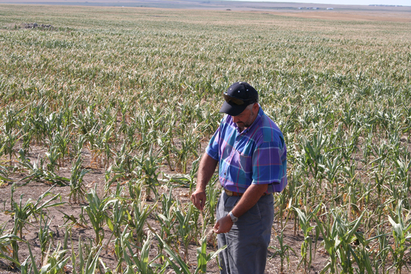
As the name suggests, flash droughts are short lived, usually lasting only a few weeks or months. But when they occur during critical growing periods, they can cause disasters. For example, in the summer of 2012, a flash drought in the central United States caused the corn crop to wither, leading to an estimated $35.7 billion in losses.
In this study, the scientists analyzed global hydroclimate data sets that use satellite soil moisture measurements to capture a global picture of flash drought and how it has changed during the past 21 years. The data showed that about 34%-46% of flash droughts came on in about five days. The rest emerge within a month, with more than 70% developing in half a month or less.
When they examined the droughts over time, they noticed the flash droughts happening more quickly.
The study also revealed the importance of humidity and variable weather patterns, with flash droughts becoming more likely when there’s a shift from humid to arid conditions. That makes regions that undergo seasonal swings in humidity — such as Southeast Asia, the Amazon Basin, and the East Coast and Gulf Coast of the United States — flash drought hot spots.
“We should pay close attention to the vulnerable regions with a high probability of concurrent soil drought and atmospheric aridity,” said Wang.
Mark Svoboda, the director of the National Drought Mitigation Center and originator of the term “flash drought,” said the advancement in drought-detecting technology and modeling tools — such as those used in this study — has led to growing awareness of the influence and impact of flash droughts. He said the next big step is translating this knowledge into on-the-ground planning.
“You can go back and watch that drought evolve in 2012 and then compare it to how that tool did,” said Svoboda, who was not part of the study. “We really have the stage well set to do a better job of tracking these droughts.”
The study was funded by the National Natural Science Foundation of China and the Hong Kong Research Grants Council.
Zephyr Minerals’ Dawson Gold Mine permitting process has been extended by at least a year after they’ve been told by the Colorado Division of Reclamation Mining and Safety that they need to drill five groundwater monitoring wells and monitor them for five quarters, as well as one compliance well. This pushes out the potential approval of the mining permit to late 2023. Under current regulations, DRMS must respond, by approving or denying the mining permit application, within one year from the date on which DRMS considered the application to be complete, July 15, 2021.
“Clearly, it is impossible timewise to do five quarters of monitoring between now and the 15th of July 2022,” said Will Felderhof, who is the executive chairman for Zephyr Minerals. “That’s why we withdraw the application, do our monitoring and then resubmit the application to address these questions regarding the information they are requesting with the water wells.”
[…]
Additionally, the decision to ask for a two-month extension will allow for more time to get more exact locations for the additional water monitoring wells. Once those are approved, he said, Zephyr will withdraw the application in order to move forward with the five quarters of water monitoring.
Bonita Mine acid mine drainage. Photo via the Animas River Stakeholders Group.
Click the link to read the opinion piece from the San Juan Citizens Alliance (Mark Pearson) on The Durango Herald website:
Our region hosts an abundance of abandoned mine sites and orphaned oil and gas wells.
They contaminate our water and air with acid mine drainage and leaking methane. They are the legacy of decades of resource extraction, and unfortunately, taxpayers often end up with the liability to reclaim the damage.
The Bipartisan Infrastructure Act passed in November includes billions of dollars for abandoned mine reclamation and plugging orphaned oil and gas wells. But more importantly, rules are needed to head off the creation of future problems.
Most of us are likely familiar with abandoned mines that dot the hillsides above Silverton and elsewhere, but the ones of most concern are those draining water laden with heavy metals. Our region also contains more 30,000 oil and gas well sites, and a surprising number are inactive with rusted equipment bleeding methane, a potent greenhouse gas.
Abandoned mines and orphaned wells are derelicts without any responsible owner willing or financially capable of reclamation. These sites are not intentionally created, but creep up on us as owners change over the decades and lose interest or capacity to keep them operating. An owner might hope that metal or oil prices will spike and lead to a resurgence of extraction, but these sites have marginal reserves to begin with, and eventually owners may just walk away, leaving someone else on the hook for cleanup.
One important means to prevent these liabilities from burdening taxpayers is to require reclamation while a financially viable owner still exists. That’s the basis of Colorado’s Mined Land Reclamation Act, which allows mines to “temporarily” cease production for a limited period. If production does not resume, then it is in the interest of the state and taxpayers to make sure reclamation starts while someone responsible is still around.
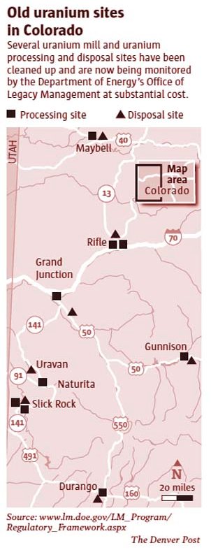
Screenshot of Old uranium sites in Colorado via The Denver Post
The uranium mines scattered across the Dolores River basin are a case in point. Most haven’t operated for decades, but over the past 40 years owners kept hoping that uranium prices might reach a level that again spurred production. But at some point, reality needs to set in and owners should start undertaking efforts to reclaim mines. That’s the point of Colorado’s reclamation law.
Orphaned oil well. Photo credit: DroneDJ.com
Orphaned oil and gas wells are similarly vexing. A nearby example is dozens of rusting, derelict, leaking wells west of Farmington in an area called the Hogback. State and federal records list these as active, but the rust and the fact one needs a high-clearance four-wheel-drive vehicle to even reach them is ample evidence the wells haven’t produced in many years. The companies associated with them have long since vanished, with phone numbers disconnected. If today’s price of oil hasn’t spurred any renewed activity, it seems unlikely anything would.
Colorado hopes to prevent additional orphaned wells by increasing bonds posted by oil companies. The bonds ideally should be ample enough to cover the costs of plugging and reclaiming wells in the event the companies disappear, so as to keep taxpayers off the hook.
It seems common sense to head off future problems, and forestall asking for billions in tax dollars like the Infrastructure Act provides, but not all agree. Right now, the mining industry is aggressively opposing rules about temporary cessation at hardrock mines, arguing for loopholes that allow mines to be idled and largely abandoned for decades, just in case someday they might again become profitable.
The plague of abandoned mines and orphaned wells proves the worth of Benjamin Franklin’s adage that an ounce of prevention is worth a pound of cure. We can hope state officials to appropriately translate that advice into rules.
Mark Pearson is executive director at San Juan Citizens Alliance. Reach him at mark@sanjuancitizens.org.
Click the link to read the article on the Colorado Public Radio website (Michael Elizabeth Sakas). Here’s an excerpt:
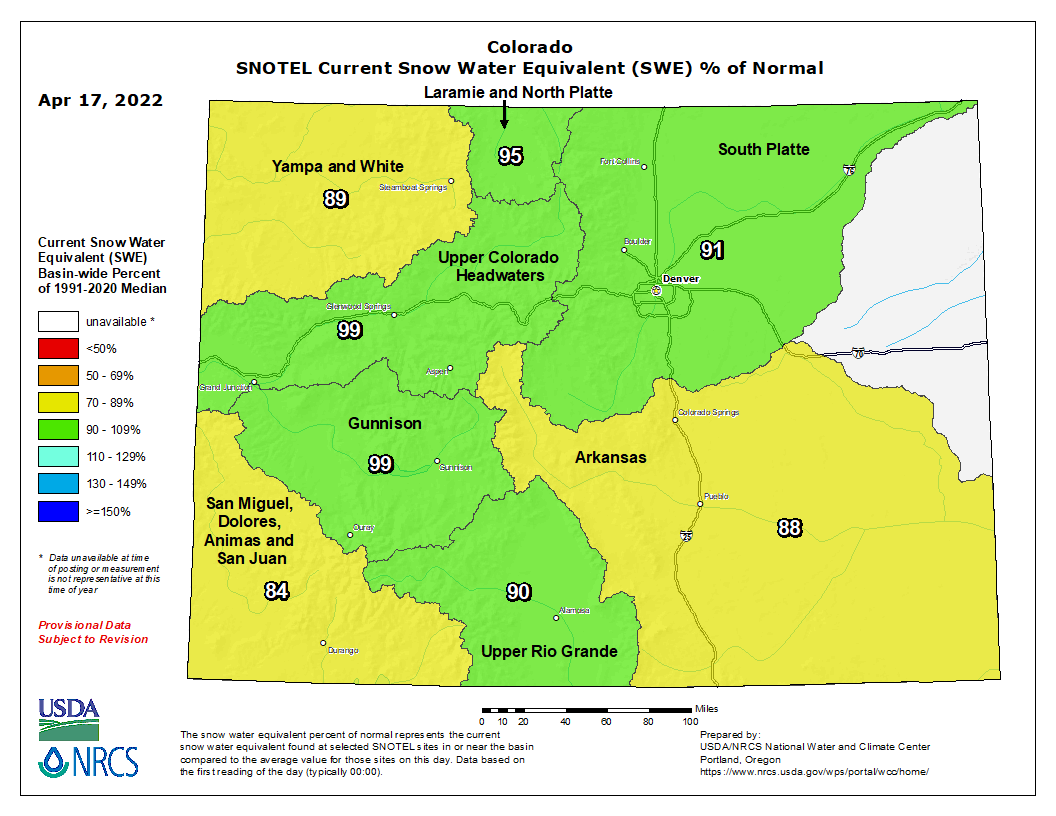
The amount of snow that’s collected in Colorado’s mountains over the winter is nearly normal for this time of year, according to the Colorado Snow Survey Program. But while statewide snowpack levels are about 91 percent of average, USDA officials say that number is starting to drop as snow in some areas starts to melt early with warmer-than-average spring temperatures…
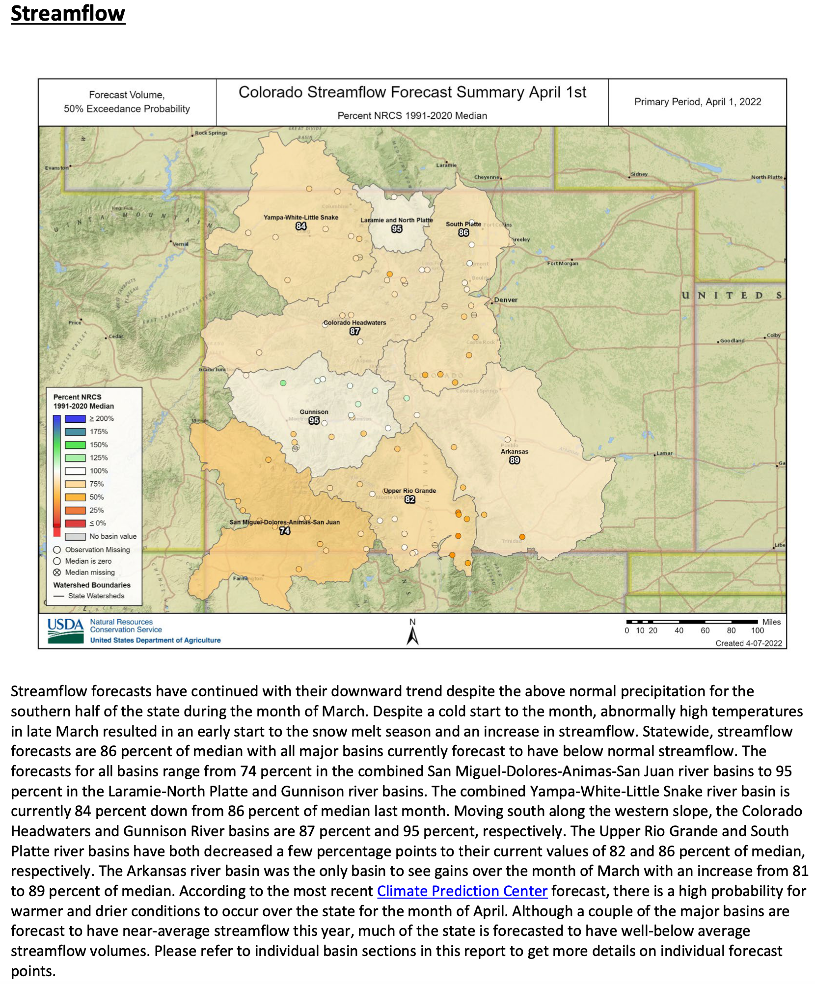
Federal data has forecasted statewide streamflow to be 86 percent of average for the 2022 season. Despite close-to-average snowfall so far, other factors like dry soil and warmer temperatures are likely to reduce the amount of snowmelt that becomes runoff and enters streams, according to a report from the USDA’s Natural Resources Conservation Service. The report also shows that all of the state’s major river basins are forecasted to have below-normal streamflow this coming summer…
Back-to-back years of drought have taken a toll on water stored in Colorado reservoirs, which currently contain about 76 percent of average storage levels, data show. Only reservoirs in the South Platte river basin have reached above-average levels. Abnormally warm temperatures in late March triggered an early start to the snowmelt season in south-central and southwest Colorado, Assistant State Climatologist Becky Bolinger said in a recent climate update. Rapid snowmelt can lead to less reliable water supplies and an increased risk of wildfire in higher elevations, she said…
Colorado Drought Monitor map April 12, 2022.
Soil on the Western Slope isn’t likely to be as dry this spring and summer as it was in 2021, which Bolinger said is good news. That means more water will make it into streams and reservoirs because the soil isn’t as thirsty. Soils are drier in the eastern part of the state, which Bolinger said will likely cause problems for farmers during the growing season. About 83 percent of Colorado is currently in a moderate drought or worse, data from the U.S. Drought Monitor show.
Colorado snowpack basin-filled map April 17, 2022 via the NRCS.
Click the link to read “Colorado Weather: Mountain Snow Completely Misses Denver Causing Soaring Fire Danger” on the CBS Denver website (Ashton Altieri). Here’s an excerpt:
The snow on Thursday and Friday [April 14-15, 2022s] will be minor compared to earlier in the week. Since Tuesday Winter Park has measured 20 inches, Snowmass has had 18 inches, Aspen Mountain has had 16 inches, and Beaver Creek measured 10 inches.
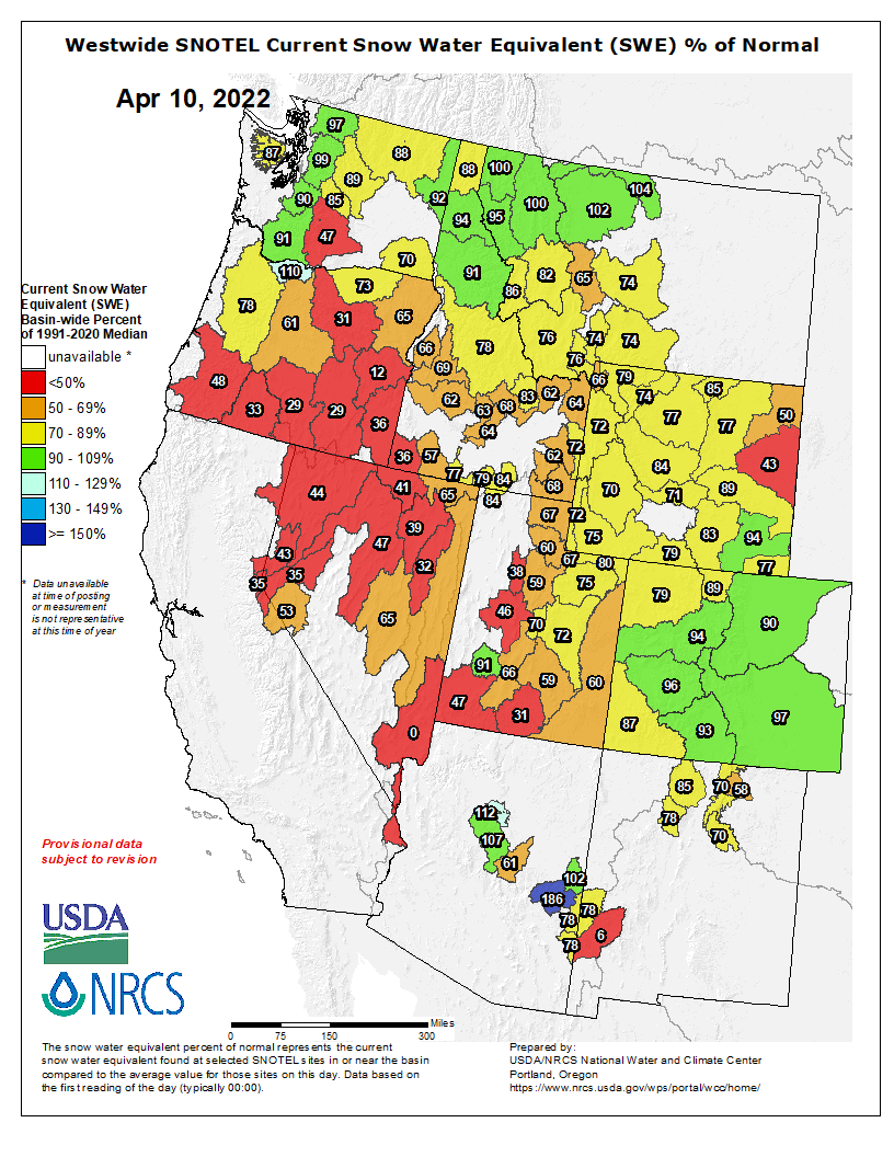
All the snow has helped snowpack to increase across all eight of Colorado’s river basins in recent days. On Monday the statewide average snowpack was 88% compared to normal. As of Thursday morning it was 92% compared to normal. Ideally water officials would perfect it to be 100% but it could obviously be much worse.
Westwide SNOTEL basin-filled map April 17, 2022 via the NRCS.
Click the link to read “Runoff into McPhee Reservoir below average from poor snowpack” on The Cortez Journal website (Jim Mimiaga). Here’s an excerpt:
Irrigation supply will be better than last year’s historic lows, but probably not by much, officials say
As of April 14, snowpack in the basin was at 70% of the average snow-water equivalent, and the runoff has started into the Dolores River and McPhee. It is too early to tell exactly how much will make it to reservoir, said Ken Curtis, general manager for the Dolores Water Conservancy District.
“We think we are better off than last year, we’re not sure yet by how much,” he said. “The low-elevation snow below 9,000 feet is gone.”
A more definitive runoff forecast is expected in the coming weeks. A special meeting will be held May 5 at 7 p.m. at the DWCD office, 60 S. Cactus, St., Cortez, to provide an update on McPhee irrigation supply.
McPhee has 37,300 acre-feet of active supply, and is filling at a rate of 3 inches per day. The reservoir has a capacity of 229,000 acre-feet active supply. Most of the current active supply in McPhee will be used to fill up adjacent Narraguinnep Reservoir, of the Montezuma Valley Irrigation District, which has started delivering water. The Dolores Water Conservancy District has begun delivering water south via the Towaoc Highline Canal to the Ute Mountain Ute Farm and Ranch operation. Water delivery in the Dove Creek Canal to northern farms is expected in early May…DWCD’s early predictions are on the conservative side, with a 90% probability of 2.5 inches per acre and a 70% probability of 6 inches per acre, still far below average…
Dust covering snow near the Grand Mesa study plot on April 26, 2014. The Grand Mesa study plot was the third to be added to the network of dust on snow monitoring stations, and began transmitting solar radiation data in 2010. CREDIT: COURTESY PHOTO BY THE CENTER FOR SNOW AND AVALANCHE STUDIES
Dust on snow is also a factor because the darker layer increases absorption of heat, melting and evaporation. It also contributed to runoff happening a week early in the Dolores River. There were five dust-on-snow events this winter in the San Juan Mountains, according to the Center for Snow and Avalanche Studies. Dust layers are in the upper third of the snowpack, and the latest layer was deposited Monday, before Tuesday’s snowstorm, said Executive Director Jeff Derry…
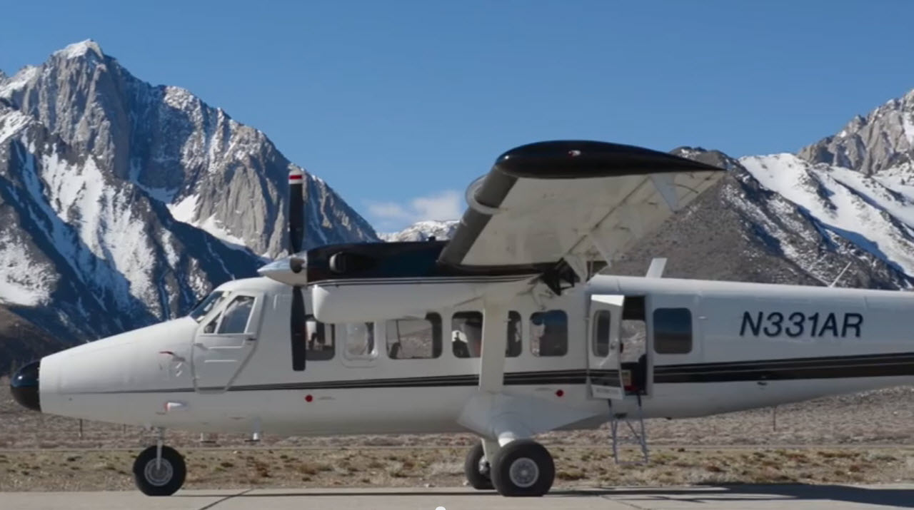
One of the two Twin Otter aircraft used by the Airborne Snow Observatory mission to study snowpack in the Western U.S. Credit: NASA
To aid in the forecast prediction, on Friday a flyover of the Dolores Basin was planned by Airborne Snow Observatories Inc. to measure snowpack depth. The plane uses technology that scans the elevation of the snow cover, then compares it with the bare ground elevation to determine snowpack.
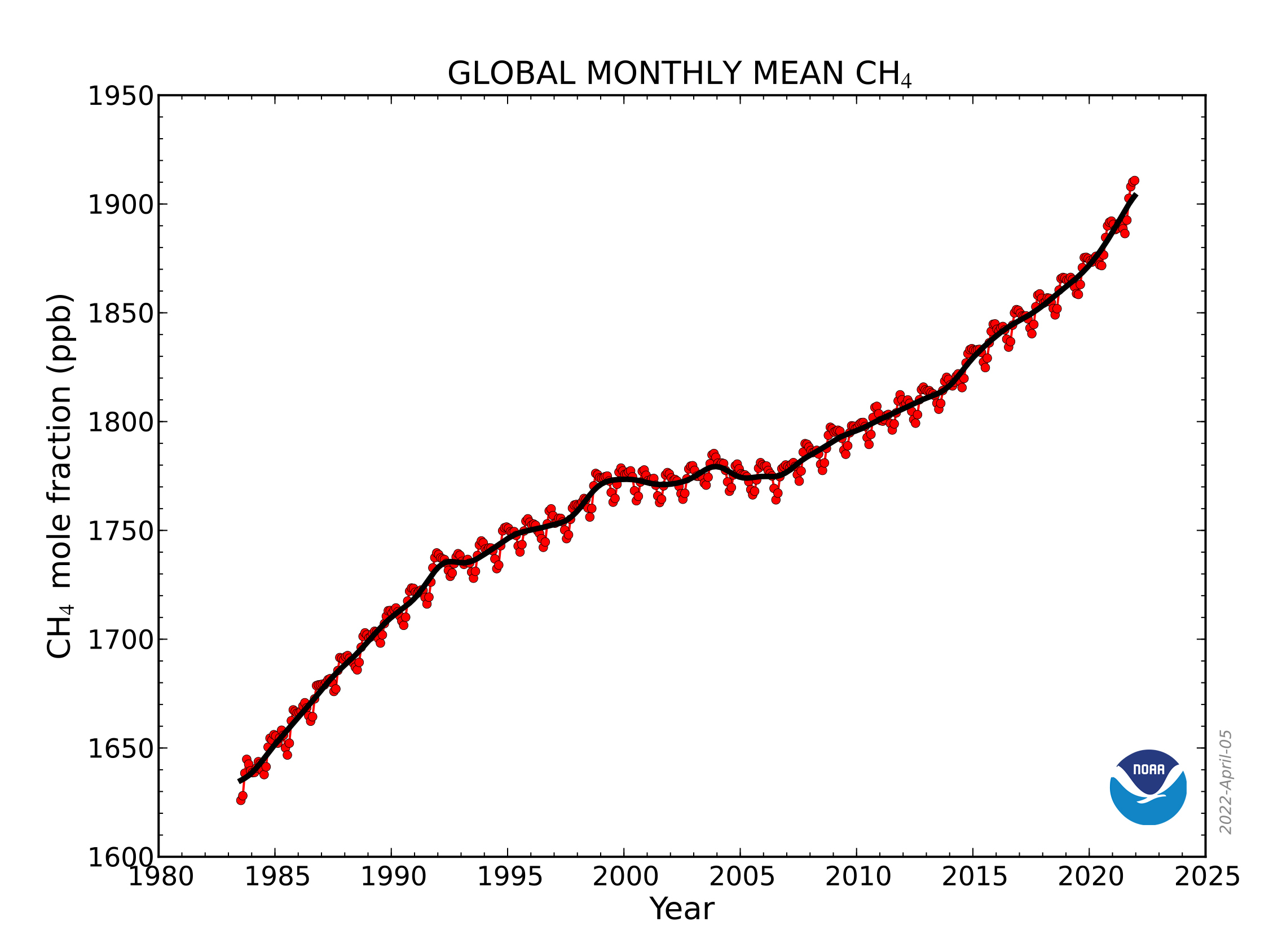
CH4 trend: This graph shows globally-averaged, monthly mean atmospheric methane abundance determined from marine surface sites since 1983. Values for the last year are preliminary. (NOAA Global Monitoring Laboratory)
Click the link to read the article on the Big Pivots website (Allen Best):
What a wallop it has during its 9-year life
Scientists last year observed a record annual increase in atmospheric levels of methane, the largest since systematic measurements began in 1983, reports the National Oceanic and Atmospheric Administration.
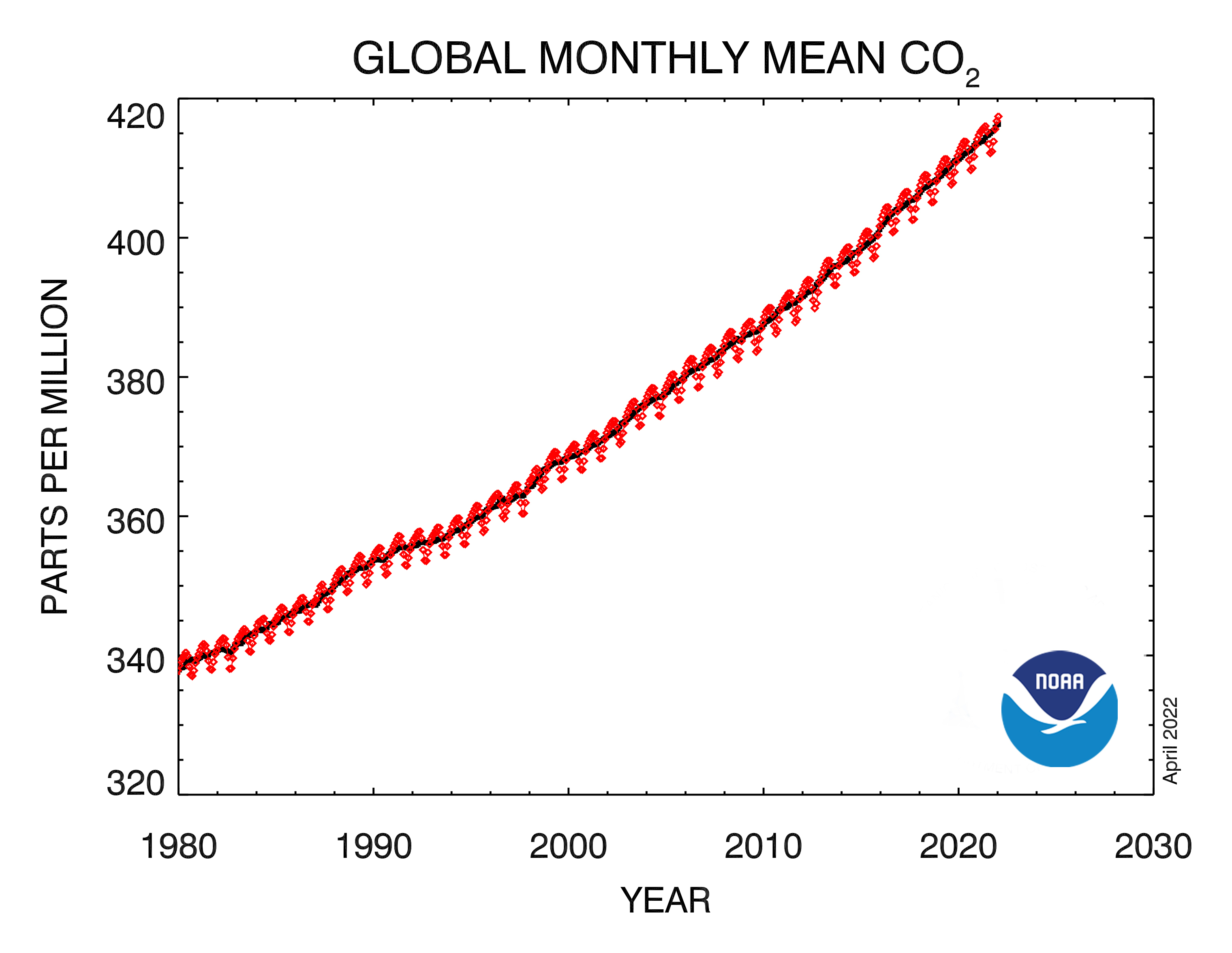
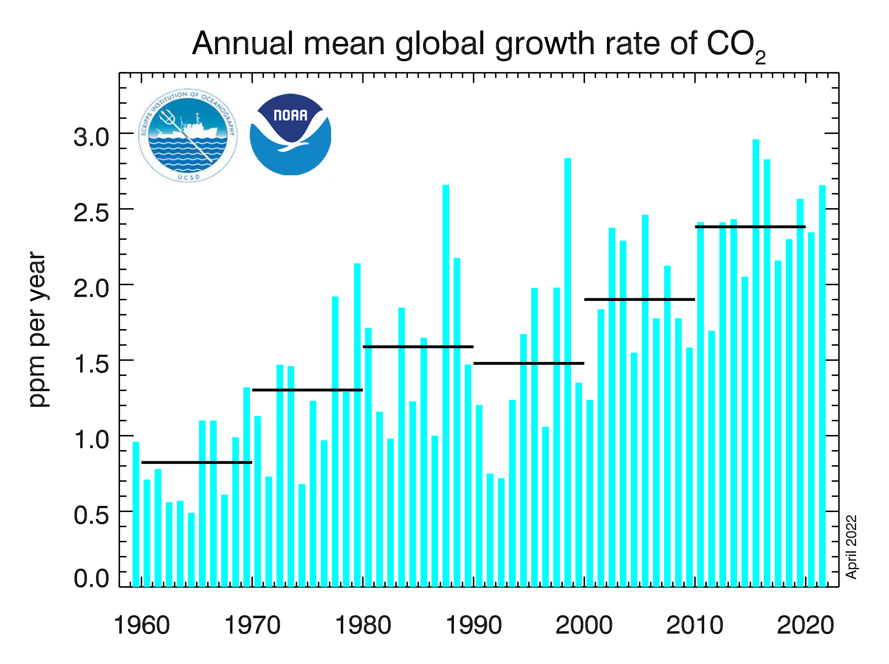
Measurements of carbon dioxide go back much longer, to the 1950s at Mauna Loa, but the story is the same. The C02 accumulations increased 2.3 parts per million in 2021 compared to the previous year. It was the 10th consecutive year for increases of more than 2 parts per million. That’s the fastest sustained rate of increase in the 63 years since monitoring began.
CO2 emissions stood at 414 ppm last year, compared to 358 when measurements began at Mauna Loa and 280 ppm before the start of the industrial era.
The last time they were this high, around 43 million years ago, sea level was about 75 feet higher than today, the average temperature was 7 degrees F higher, and large forests occupied areas of the Arctic that are now tundra.
Carbon dioxide dissipates slowly, over thousands of years.
“About 40% of the Ford Model T emissions from 1911 are still in the air today,” said Pieter Tans, senior scientist with the Global Monitoring Laboratory. “We’re halfway to doubling the abundance of carbon dioxide that was in the atmosphere at the start of the Industrial Revolution.
Methane lingers in the atmosphere only 9 years, but during that relatively brief time it has vastly more heat-trapping properties than carbon dioxide.
Beef cattle on a feedlot in the Texas Panhandle. Photo credit: Wikimedia
Atmospheric methane comes from many sources, including fossil fuel extraction, from the decay of organic matter in wetlands, and as a byproduct of digestion by ruminant animals, including cows.
In Boulder, the Institute of Arctic and Alpine Research at the University of Colorado has conducted research that indicates biological sources of methane such as wetlands or ruminant agriculture are a primary driver of post-2006 increases in methane. What this means, say NOAA scientists, is that a feedback loop may be occurring. In other words, more warming begets more methane, in this case more rain over wetlands in the Tropics that would largely be beyond the ability of humans to control.
Determining which specific sources are responsible for variations in annual increases of methane is complex, says NOAA, but scientists estimate that fossil fuel production and use contributes roughly 30% of the total methane emissions.
Scientists from the International Panel on Climate Change issued another warning in early April of the need to immediately slash emissions to keep temperature rise below 2.7 degrees F. That report also cited three actions—reducing the destruction of forests and other ecosystems, restoring them, and improving the management of working lands, such as farms—as among the top five most effective strategies for mitigating carbon emissions by 2030.
Electricity produced at Lake Powell’s Glen Canyon Dam, which serves some 50 Colorado utilities, and dozens of others in the Colorado River Basin, has been cut in half by the 20-year drought, with power levels over the next two years projected to be 47% lower than normal, according to the U.S. Bureau of Reclamation.
“We’re going to be generating less than we have in quite some time. It will be among the lowest years of generation ever,” said Nick Williams, power manager for the U.S. Bureau of Reclamation’s Upper Colorado River Region in an interview last week.
The grim forecast comes as water officials race to bolster Lake Powell’s water levels. On April 8, Reclamation announced it would likely keep more water in Lake Powell, reducing releases from the planned 7.5 million acre-feet to 7 million acre-feet, a move that could trigger emergency water cutbacks in Arizona, California and Nevada.
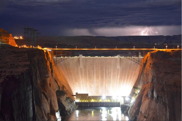
Hydroelectric Dam
At the same time, electric utilities across the West are looking for other green power options and hoping that hydropower production won’t stop altogether. According to Reclamation, there is a 27% chance that Powell will still stop generating electricity completely over the next four years.
“If Glen Canyon Dam ceases to operate, we are going to have to replace that power somewhere else and it will have a bigger carbon footprint,” said Bryan Hannegan, CEO of Holy Cross Energy, which buys Lake Powell’s hydropower to serve customers in Western Colorado.
The picture was much different 60 years ago, when the giant storage reservoir on the Colorado River was filling, its electricity helping power the West and the revenue from its power sales helping fund endangered fish protection programs across the Colorado River Basin.
Back then, Hannegan said, “We made an assumption that our WAPA (Western Area Power Administration) allocation would be firm, reliable and always there. Now, though, we know that it’s not firm, it’s not reliable, and it’s coming at a much higher cost.”
Late last fall WAPA, which operates the electric grid and distributes the power to utilities, raised rates 30% to cover reductions in power revenue. Few expected to ever see this drop in hydropower production, let alone consider what to do if Glen Canyon were to cease electricity production entirely.
“The forecast is changing daily and there are still a lot of variables,” said Lisa Meiman, a spokeswoman for WAPA. ”But it is concerning. This is the big warning bell.”
The drop in the power forecast comes as Upper Colorado River Basin states of Colorado, New Mexico, Utah and Wyoming prepare to finalize a new drought operations plan for the giant river system. The draft plan is expected to be released next week, according to Becki Bryant, a spokeswoman for Reclamation’s Upper Colorado River Region.
The critical issue is how to maintain the lake at 3,525, which marks an elevation that is the top of the liquid buffer zone designed to protect the lake’s mighty electricity turbines.
Last July, to protect the 3,525 buffer zone, Reclamation ordered emergency water releases from three reservoirs in the Upper Colorado River Basin. Utah’s Flaming Gorge, Colorado’s Blue Mesa and New Mexico’s Navajo.
Despite those releases, Powell dropped below 3,525 last month, hitting 3,523, another historic drought landmark.
Though the 2022 forecast isn’t expected to be finalized until later this month, water officials expect that more water will have to be released from Upper Basin storage reservoirs this summer because inflows into the lake from the drought-stressed Colorado River are expected to be well below average again, in the 60% to 80% range.
Becky Mitchell is director of the Colorado Water Conservation Board, the state’s lead water planning agency. She also sits on the Upper Colorado River Commission. Mitchell declined to discuss the pending drought operations plan. But in a statement, she said, “The Upper Basin States are working collaboratively with the Bureau of Reclamation to draft a 2022 Drought Response Operations Plan outlining potential releases from Upper Basin reservoirs in an effort to protect critical elevations at Lake Powell. The Upper Basin reservoirs have already provided 161,000 acre-feet of water pursuant to the ’imminent need‘ provision of the Drought Response Operations Agreement, including 36,000 acre-feet from Blue Mesa Reservoir in Colorado. Water availability, appropriate timing of releases, and impacts on other resources are all being considered as the 2022 Plan is being drafted.”
Across the region, water utilities are in high-alert mode, preparing for another dry year on the Colorado River and holding hope that the Upper Basin reservoirs can be protected as long as possible from large-scale drought releases.
“The forecast isn’t great,” said Kyle Whitaker, Colorado River Manager for the Northern Colorado Water Conservancy District, one of the largest diverters of water in the headwaters region of the river.
“It’s better than last year, but we’ll just have to see what the next two to four weeks holds for precipitation.”
At the same time, power producers are gearing up to craft a fallback plan for extending hydropower production at Glen Canyon Dam if water levels continue to fall.
“We have to take a strong look at what we will do in the unlikely event that Lake Powell stops producing hydropower,” said WAPA’s Meiman. “It’s not a hypothetical situation anymore.”
Jerd Smith is editor of Fresh Water News. She can be reached at 720-398-6474, via email at jerd@wateredco.org or @jerd_smith.
Lake Powell, just upstream from Glen Canyon Dam. At the time of this photo, in May 2021, Lake Powell was 34% full. (Ted Wood/The Water Desk)
Click the link to read the article on the KUNC website (Alex Hager). Here’s an excerpt:
Lake Powell is in crisis. The nation’s second-largest reservoir is strained by more than two decades of drought, and its water levels are slipping dangerously low. In March, the reservoir passed an important threshold. Water levels dipped below 3,525 feet — the last major milestone before a serious threat to hydropower generation at the Glen Canyon Dam. The future of the reservoir is largely uncertain, but climate science and recent actions by the government are providing some hints as to what might happen in the near future…
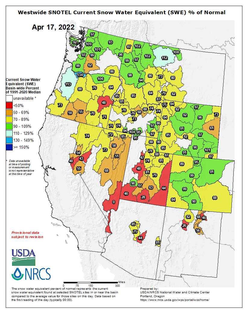
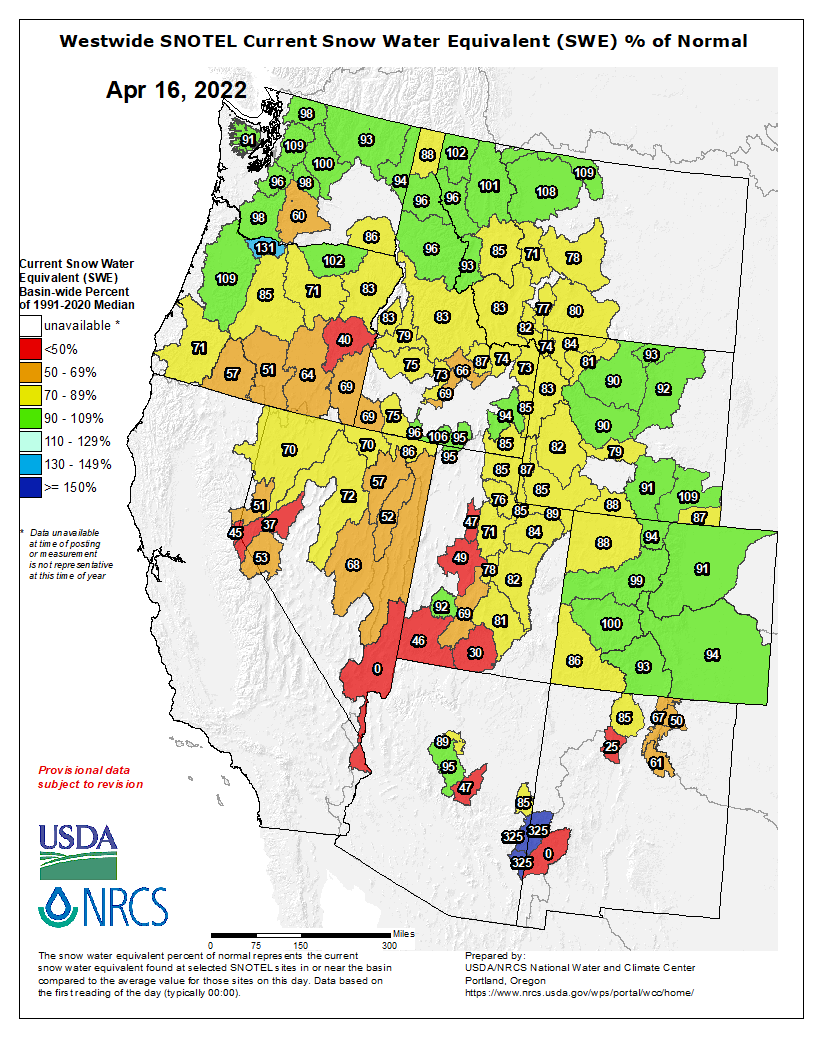
Westwide SNOTEL basin-filled map April 16, 2022 via the NRCS.
Will water levels go back up?
In the short term, yes. In the long term, probably not. While levels are on a long downward trend, they fluctuate with the seasons. A large portion of the water in the Colorado River and Lake Powell comes from high-mountain snowmelt in Colorado and Wyoming. Because of that, the spring and early summer will bring a temporary boost to water levels while snow runs into rivers and eventually flows into Lake Powell. Mountain snowpack is generally below average for this time of year, so that boost may not be as big as it has been in years past.
Forecasts are calling for 4.1 million acre-feet of water to flow into Lake Powell from April to July this year, but water managers are obligated to release more than 7 million acre-feet out of the lake. An acre-foot is the amount of water needed to fill one acre of land to a height of one foot. One acre-foot generally provides enough water for one to two households for a year…
Brad Udall: Here’s the latest version of my 4-Panel plot thru Water Year (Oct-Sep) of 2021 of the Colorado River big reservoirs, natural flows, precipitation, and temperature. Data (PRISM) goes back or 1906 (or 1935 for reservoirs.) This updates previous work with @GreatLakesPeck.
What is the long-term future of Lake Powell?
All signs point to a hotter, drier future for the Western U.S. The big question is how water managers will divvy up a shrinking supply to feed a growing region. Climate change is driving more than two decades of drought across the region, and making it increasingly unlikely that Lake Powell will ever climb back to previous levels.
Click the link to read the article on the Pagosa Springs Sun website (Dorothy Elder). Here’s an excerpt:
At its April 6 meeting, the Pagosa Springs Sanitation General Improvement District Board of Directors authorized up to $120,000 to be spent out of the sanitation fund reserve for additional emergency expenditures, most of which are meant to safeguard the system from an emergency as the sanitation system’s issues continue to worsen. The system has two pump stations. Each pump station is meant to have two pump trains and four pumps, and each is down to a single pump train with two pumps, Manager Andrea Phillips reminded the board on Wednesday.
The Attorney General’s Office today [April 11, 2022] asked the Colorado Supreme Court to review a case that threatens to upend how water and access to Colorado rivers have been managed since Colorado joined the Union.
“Recreation on Colorado’s rivers is vital to Colorado’s economy and our way of life. For decades, property owners, water users, and leaders in the recreation industry have worked together to increase public access to rivers for recreation. Many cities, farms, and other water rights holders have relied on our settled rules to invest in critical infrastructure that sustains our agricultural communities and supports our cities. This lawsuit puts these agreements and practices at risk,” Weiser said. “If this longstanding Colorado approach to water and river access is to change, the decision-making process rightly belongs to the legislative and executive branches of government. Courts should not upend this long-settled practice.”
When Colorado became a state, who owned the bed of the river depended on whether it was navigable. Title to the bed of any navigable river would have passed to the State of Colorado, while title to the beds of non-navigable rivers remained with the United States. No river within Colorado was declared navigable at statehood, so title to all riverbeds remained with the United States when Colorado became a state. The federal government has given title to its non-navigable riverbeds to streamside landowners through federal patents. Here, one person is trying to get courts to change this rule on a river-segment by river-segment basis. But to disturb these long-settled holdings, the legislative and executive branches need to start a comprehensive process to consider all important factors and establish state-wide standards.
Over the last several decades, state and federal partners have worked together to increase fishing access, delineate private land boundaries, and increase public education about public access to the river. And water users have relied on this settled ownership to build improvements so that cities and farms can efficiently use their water. In this case, someone tried to fish on a segment of the Arkansas River that is on private property and not open to the public. After trespassing and being refused access by the property owners, he sued the landowners, claiming that a court should order that the riverbed belonged to the state and, as a member of the public, he had a right to use it.
A district court and the Colorado Court of Appeals ruled that this person had no claim to title and failed to show a legally protected right in that title. But the Court of Appeals also concluded that Hill could continue with his lawsuit and seek a court order preventing the private landowners from denying him access to the river because of his theory that title to the riverbed passed to the state at statehood.
According to the state’s filing, if the case is allowed to proceed, it would force courts to determine navigability for every river and stream in Colorado and have staggering implications for settled agreements governing the use of our state’s rivers. Since Colorado became a state, the state legislature and Governor have never advanced the position that the state actually owns any of the riverbeds in Colorado. This case is seeking to allow an individual to make this decision on behalf of the state.
Click the link to read the article on the News on Tap website (Todd Hartman):
With the 2021-22 snow season winding down, Denver Water is getting a clearer look at water supplies approaching the irrigation, gardening and summer recreation season.
In fact, as 9News meteorologist Cory Reppenhagen has pointed out, much of Colorado likely hit its peak snowpack in late March, meaning we’ve started the process of spring runoff, when the snowpack begins to melt and flow into streams, rivers and reservoirs.
(Caption: Watch Denver Water crews weigh the snow to find out how much water it contains.)
In Denver Water’s collection system, which includes parts of the South Platte River and Colorado River basins, it’s not fully certain we’ve hit our peak — the point when snowpack reaches its highest point before melting off.
But we’re surely close, as snowpack in Denver Water’s collection system typically peaks around April 20.
What’s it all mean for our water supply? It’s a mixed picture.
Snowpack is a bit below average, but soil moisture has improved compared to last year, meaning more melting snow will find its way to reservoirs and less will disappear into thirsty ground.
Denver Water’s reservoirs are 79% full, on average, which is normal for this period. And runoff is likely to push that number north of 90% when storage peaks midsummer.
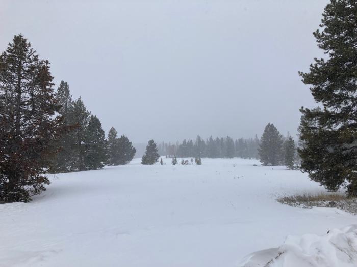
A mid-April snowstorm delivered several inches of snow to Colorado’s high country. Photo credit: Denver Water.
“Overall, we’d like the numbers to be higher, but with better soil moisture we expect better runoff than in recent years with similar snowpack,” said Nathan Elder, manager of water supply for Denver Water.
“We have good carry-over storage going into the runoff season because of low winter water use,” he added. “That’s a reflection of good work from our customers in continuing to improve indoor efficiency and water use habits.”
It’s important those good habits extend into the watering season; customers with spring fever should try not to get ahead of things with outdoor irrigation.
Warning! April is too early to turn on hoses, sprinklers and irrigation systems.
A string of snowstorms this year has improved soil moisture in the Denver region. And more storms could still head our way in late April and early May. This time of year, the weather can be unpredictable, and you might think spring has sprung — only to have winter sweep back in for a last goodbye.
And planting ahead of Mother’s Day (May 8 this year) is always a gamble, as the potential overnight freezes still lurk into the early days of the month. Cold temperatures can put an early end to spring seedlings and damage irrigation systems if water inside the piping freezes.
As it stands in mid-April, snowpack is at 88% of average in Denver Water’s Colorado River collection system, and at 74% of average in its South Platte system, though that South Platte figure is affected by a single tracking location with poor snow that has pulled down the broader average; in the wider South Platte River basin, snowpack is currently 90% of normal.
Don’t turn on your sprinklers yet. Late spring snowstorms can easily damage irrigation systems. Photo credit: Denver Water.
And a big wet storm or two, still possible this time of year, would improve the outlook.
Additionally, planned Airborne Snow Observatories (ASO) flights, which measure high elevation snowpack with great precision, will bring additional insight into the snowpack, as well as adjustment to the runoff outlook.
In 2019, flights in the Blue River Basin above Dillon Reservoir revealed more snow than expected at elevations above traditional snow telemetry sites that provide most snowpack data.
“The ASO data gives us the most detailed and accurate insight into snowpack,” said Taylor Winchell, a climate change specialist at Denver Water. “We look forward to seeing what new information that tells us this spring and how it narrows the uncertainty of water supply forecasts.”
Upper Colorado River Endangered Fish Recovery Program
Click the link to read the release on the Reclamation website (Robert Manning):
The Bureau of Reclamation today submitted its initial spend plan for fiscal year 2022 funding allocations authorized in the Bipartisan Infrastructure Law to the U.S. Congress. This spend plan represents a blueprint for how Reclamation will invest in communities to address drought across the West as well as greater water infrastructure throughout the country. Reclamation will be provided $1.66 billion annually to support a range of infrastructure improvements for fiscal years 2022 through 2026.
“The Bipartisan Infrastructure Law is the largest investment in the resilience of physical and natural systems in American history,” said Assistant Secretary for Water and Science Tanya Trujillo. “Reclamation’s funding allocation for 2022 is focused on developing lasting solutions to help communities tackle the climate crisis while advancing environmental justice.”
“The Bureau of Reclamation serves as the water and power infrastructure backbone for the American West. The law represents a once-in-a-generation opportunity to improve our infrastructure while promoting job creation,” said Reclamation Commissioner Camille Calimlim Touton. “The funding identified in this spend plan is the first-step in implementing the Bipartisan Infrastructure Law and will bolster climate resilience and protect communities through a robust investment in infrastructure.”
The FY 2022 spend plan allocations include:
$420 million for rural water projects that benefit various Tribal and non-Tribal underserved communities by increasing access to potable water.
$245 million for WaterSMART Title XVI that supports the planning, design, and construction of water recycling and reuse projects.
$210 million for construction of water storage, groundwater storage and conveyance project infrastructure.
$160 million for WaterSMART Grants to support Reclamation efforts to work cooperatively with states, Tribes, and local entities to implement infrastructure investments to increase water supply.
$100 million for aging infrastructure for major repairs and rehabilitation of facilities.
$100 million for safety of dams to implement safety modifications of critical infrastructure.
$50 million for the implementation of Colorado River Basin drought contingency plans to support the goal of reducing the risk of Lake Mead and Lake Powell reaching critically low water levels.
$18 million for WaterSMART’s Cooperative Watershed Management Program for watershed planning and restoration projects for watershed groups.
$15 million for Research and Development’s Desalination and Water Purification Program for construction efforts to address ocean or brackish water desalination.
$8.5 million for Colorado River Basin Endangered Species Recovery and Conservation Programs.
Detailed information on the programs and funding provided in the Bipartisan Infrastructure Law, the FY 2022 BIL Spend Plan and materials from recent stakeholder listening sessions are available at http://www.usbr.gov/bil.
This year marks the 100th anniversary of the Colorado River Compact, an innovative and influential legal agreement among seven U.S. states that governs water rights to the Colorado River. In recognition of this anniversary, the Colorado State University Libraries will be spotlighting a series of stories in SOURCE about the ripple effects of this 100-year-old document on diverse people, disciplines and industries in 2022.
Nestled in the spires of Colorado’s Rocky Mountains lie acres of crystalline snowpack, slowly carving the granite formations where they rest. The snowpack feeds a litany of creeks and rivulets that form the Colorado River, the bedrock of the West’s water supply.
Snow is crucial to fulfilling the Colorado River Compact’s promise of 15 million acre-feet allocations split between the upper and lower basins. Nearly 40 million people among seven Western states depend on the river’s swift currents to power their daily lives – which snowpack monitoring helps inform by creating more accurate predictions of how much snowmelt will make its way downstream.
Guided by the Compact’s allocations, snowmelt is a critical facet of water history and planning that is not often considered in detail, though it directly influences outdoor recreation and hydrology.
Members of the Colorado River Commission, in Santa Fe in 1922, after signing the Colorado River Compact. From left, W. S. Norviel (Arizona), Delph E. Carpenter (Colorado), Herbert Hoover (Secretary of Commerce and Chairman of Commission), R. E. Caldwell (Utah), Clarence C. Stetson (Executive Secretary of Commission), Stephen B. Davis, Jr. (New Mexico), Frank C. Emerson (Wyoming), W. F. McClure (California), and James G. Scrugham (Nevada) CREDIT: COLORADO STATE UNIVERSITY WATER RESOURCES ARCHIVE via Aspen Journalism
“It’s been 100 years since the Colorado River Compact has been signed, and one of the issues … is that the conditions in the river that existed prior to 1922 (were) not constant. and they were more than what we see in the long-term average. They had a short window and used those quantities to estimate who got what,” said CSU Professor Steven Fassnacht, who studies snow hydrology.
In the midst of a research expedition in Cataract Canyon, Utah, former USGS Chief Hydrologist Luna Leopold and eminent physicist Ralph Bagnold take a moment to rest
Hydrologists did not measure snowpack until 1936, when the aftermath of the Dust Bowl spurred the newly created Soil Conservation Service to measure snowpack.
These measurements helped give farmers a holistic perspective into the Colorado’s entire watershed and ensured they were aware of moisture levels before planting and irrigating crops.
However, snowpack measurements and actual water levels in the Colorado can vary significantly given the river’s dynamic nature, which has spurred hydrologists to take more complete snapshots of mountain ecosystems with improved snow measurements.
People may never be able to fully predict the river’s water levels, but modern snow measurement systems give scientists a better idea by measuring a wealth of environmental factors.
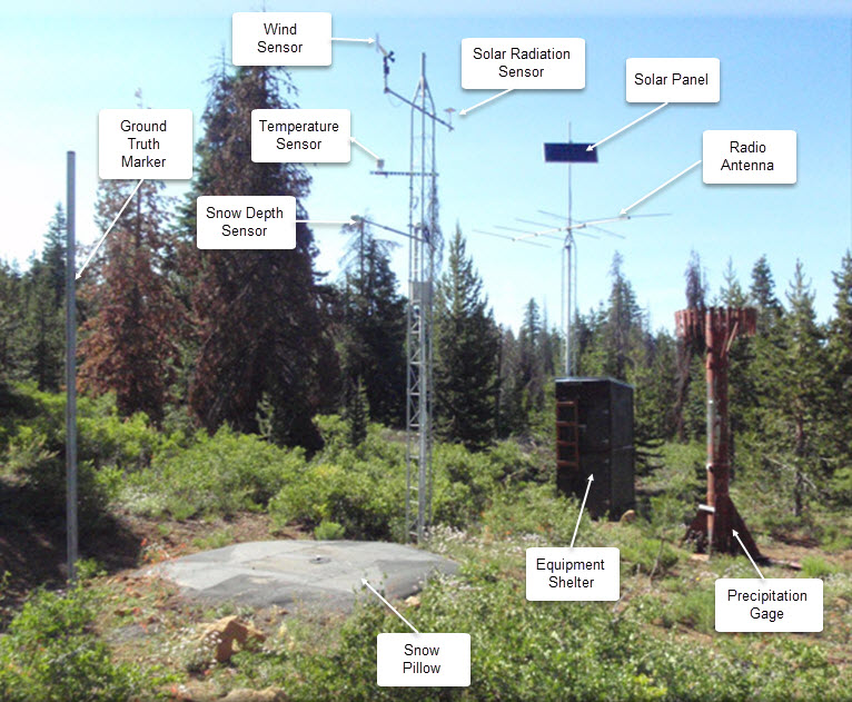
SNOTEL automated data collection site. Credit: NRCS
Today, a nationwide network of Snow Telemetry, or SNOTEL, sites inform the National Weather Service by giving daily information on precipitation, snowpack and soil moisture to better indicate how much snowmelt will end up in river sheds.
Map of the Colorado River drainage basin, created using USGS data. By Shannon1 Creative Commons Attribution-Share Alike 4.0
Climate change impacts on snowpack
“Over the 80-to-90-year period of snow courses, these watersheds have changed,” Fassnacht said. “There’s been land use conversion, fire, insect infestation and a lot of disturbances to the forest. Climate change is making the conditions different – the system is getting warmer, and trees are growing at higher elevations.”
As the West’s climates become more varied and unpredictable, so too will the structure of snow, according to Fassnacht. Heavy snowfalls layered on top of melting snowbanks will create more variation between snow layers, which creates unstable snow. Greater variations in temperature between October and February further creates fluctuations in snowpack and weakens the stability of the bottom layer, which can trigger more avalanches.
Moreover, the Lower Basin downstream of Lake Powell, has experienced unprecedented drought in the past 20 years that has changed how California, Arizona, Nevada and New Mexico use water.
In fact, the Colorado River no longer reaches the Pacific, instead reduced to a scorched delta dotted with skeletal capillaries that whisper of the river’s once-powerful current. The Upper Basin upstream of Lake Powell, though, has not seen the same reduction in the overall amount of snowpack, although the distribution of snow has changed.
“We all want to be able to get the sound bite, tweet out the simple answer, but we’ve seen over the past few years that things are complex,” Fassnacht said. “In northern Colorado, stations at lower elevations are actually getting more snow, and higher elevations are getting less snow. That doesn’t match up with things warming up everywhere, because then lower elevations would have more rain than snow.”
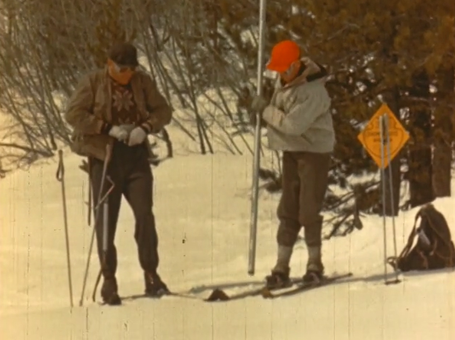
The federal Snow Survey Program provided mountain snowpack data and water supply forecasts to Western states. The U.S. Department of Agriculture produced a film in 1952 about the work of snow surveyors. (Photo courtesy CSU Libraries)
Snow and water usage at ski resorts
These findings hold particular relevance for snow-dependent activities like skiing and snowboarding. Keeping a slope covered in crystals requires massive quantities of water, which Fassnacht has helped watershed science students investigate in practicum courses at Copper and Winter Park.
Snowmaking is a water-intensive activity that heavily relies on local rivers, and as snowfall becomes more varied among elevations, it will become even more important for ski areas to reduce their water consumption – and even threatens the future of the Winter Olympics.
“The entire industry is reliant on frozen water falling from the sky every winter on a consistent basis, and it doesn’t, which makes skiing a difficult industry to make money. That is why ski resorts are more about real estate sales, retail and cheap season passes than just skiing,” said Michael Childers, an associate professor in history at CSU. “The real money has always been in real estate, which has led to the rampant growth of ski towns, which has led to increasing water use in those regions whose water is actually owned by agricultural and urban interests who are also increasingly thirsty.”
The future of an environmental good
Ultimately, the future of snow in the West depends on an improved understanding of the CRC and the Law of the River, the composite body of laws that govern the Colorado River’s water and infrastructure.
The Compact’s original designations to states – and the document’s reliance on uncharacteristically high-water levels – have allowed for the over-allocation of the river’s resources and its slow decline. With more inconsistent winters, the entire basin faces unprecedented water scarcity that could soon see the extinction of the high Rockies’ glimmering snowfields.
“Water is an environmental good – we’re only recently starting to recognize that with water law,” Fassnacht said. “Current water law restricts what we can do, but we need to consider the sustainability of what we’re doing with these water systems. We’re only starting to integrate the different players and stakeholders, but we need to work together more.”
He added: “We need to invite everyone to the table, have a frank conversation, and think about what the ramifications are, since this is a system that has global implications.”
A half day virtual educational seminar explaining the complicated and often confusing issues surrounding water in SW Colorado.
About this event
Water Law in a Nutshell Workshop
Led by Mr. Aaron Clay, Attorney at Law and former 26-year Water Referee for the Colorado Water Court, Division 4
Friday, April 22, 2022
9:00 AM to 1:00 PM Virtual Live On-Line Course
**Details and link access will be sent directly to you after you register and a couple days prior to the start of the course.
Continuing Education Credits Available:
Realtors: 4 hours CE
Attorneys: 4 hours CLE
Once again we are pleased to present the Water Law in a Nutshell course. A great opportunity to learn with Aaron Clay in an online setting about all aspects of the law related to water rights and ditch rights as applied in Colorado. Subject matter includes the appropriation, perfection, use, limitations, attributes, abandonment and enforcement of various types of water rights. Additional subject matter will include special rules for groundwater, public rights in appropriated water, interstate compacts and more.
From his 26 years as a water referee at the Colorado Water Court, Clay brings his wealth of knowledge that earned him a reputation as one of the top experts in water law to this “Water in a Nutshell” course.
Even if you have done this course before, it is a great refresher as there is so much information to absorb!
We welcome EVERYONE, from anywhere in Colorado, including landowners, realtors, lawyers, water district employees, and anyone else interested in water law.
American Dipper, Lolo National Forest, Montana. Photo: Troy Gruetzmacher/Audubon Photography Awards
Click the link to read the article on the Audubon website (Caitlin Wall):
In March, Congress passed and President Biden signed a federal spending bill that will fund the government through September 30, 2022. Overall, the funding is a win for conservation and provides helpful increases for programs that address climate change, build community resilience, and protect birds and wildlife. Compared with four years of drastic funding cuts implemented from 2016-2020, this bill sets the stage for a positive trend in federal funding for the environment.
One bright spot is the (at least) $1.25 million included for Saline Lakes science, a key Audubon priority. In addition to this startup funding, Audubon is hopeful that Congress works to pass the bipartisan Saline Lake Ecosystems in the Great Basin States Program Act and additional appropriations for this critical assessment and monitoring program.
For the Colorado River, the spending bill is a bit of a mixed bag. The Cooperative Watershed Management Program received only $5 million, which is a slight increase over the $4.25 million it received last year, but far below our request of $20 million. However, this program received a huge boost in the Infrastructure Investment and Jobs Act (IIJA)—$200 million over five years. And the relatively new Aquatic Ecosystem Restoration Program received only $100,000 in Fiscal Year (FY)22, but will benefit from $250 million over five years in IIJA funding. These programs fund multi-benefit projects that support rivers, wetlands, communities, and water users and we are hopeful they continue to receive additional funding in future years. Audubon urges Congress to continue boosting annual funding for programs like these. Coupled with the historic amounts of funding in the IIJA, the river is receiving an influx of funding over the next few years to address the ongoing drought and water challenges.
Yuma desalting plant. Photo credit: USBR
We were also pleased to see that funding for the operation of the Yuma Desalting Plant was prohibited by the omnibus bill. Audubon remains opposed to the operation of the Yuma Desalting Plant, and encourages Congress to continue prohibiting appropriations for this purpose, as it would decimate irreplaceable bird habitat in the Colorado River Delta, particularly in the Ciénega de Santa Clara. And, the Lower Colorado River Basin received $25 million to implement the Drought Contingency Plans (DCP); this critical funding is in addition to $250 million in the IIJA, pointing to ongoing interest in ensuring these plans are implemented effectively.
For the Department of Agriculture, several important conservation programs were fully funded (meaning they received no cuts)—these include the Regional Conservation Partnership Program (RCPP) and the Environmental Quality Incentives Program (EQIP). RCPP promotes innovative regional approaches to improve the health of working landscapes and rivers with partner-driven, multi-benefit projects. EQIP promotes the voluntary application of land use practices to maintain or improve the condition of natural resources, including grassland health, water quality, and wildlife habitat. Both of these helps support overall watershed health and build the resilience of these ecosystems.
The Salton Sea is a major nesting, wintering and stopover site for about 400 bird species (Source: California Department of Water Resources)
Finally, the FY22 spending bill included Congressionally Directed Spending projects (previously known as earmarks) for the first time in many years. Audubon supported numerous project requests, and was pleased to see $2.546 million for a Salton Sea Research Project, secured by Representative Vargas. And, Representative Stanton secured $1.841 million for the Tres Rios project in Arizona, which Audubon also supported.
Audubon looks forward to the implementation of this funding for on-the-ground conservation activities, habitat restoration projects, and community resilience efforts. Federal dollars are critical to addressing climate change and the ongoing Western drought and aridification. Protecting watersheds protects people and birds, particularly in the West.
Looking ahead, President Biden released his FY23 budget on March 28, which initiated the appropriations process for the rest of this fiscal year. While the budget is only a statement of priorities and Congress will decide the actual spending amounts, Audubon was pleased to see investments for clean energy research, a civilian conservation corps, and equity initiatives to help historically marginalized communities.
The budget appropriates $1.4 billion for the Bureau of Reclamation, which oversees the West’s major waterways. This funding would include $2.254 million for the Cooperative Watershed Management Program and $500,000 for the Aquatic Ecosystem Restoration Program. Audubon urges Congress to fully fund these programs at $20 million and $15 million, respectively. Audubon also supports a full $5 million for the Saline Lakes science program at USGS, to build upon the initial investment made last year. We will be working with our partners to support other conservation programs and projects for FY23, and help continue this positive trend in funding.
Audubon urges the Administration and Congress to continue increasing funding amounts for programs that restore habitat, build community resilience, combat climate change and its devastating effects, and protect the places that people and birds need.
A “rooster tail” is formed by the water descending the Granby Dam spillway on July 19, 2019. Photo credit: Northern Water
Here’s the release from Northern Water (Jeff Stahla):
The Northern Water Board of Directors voted unanimously Thursday to increase its 2022 quota allocation for the Colorado-Big Thompson Project to 70 percent.
Board members expressed their desire to take a conservative approach that protects the ability of the C-BT Project to provide a water supply to its beneficiaries while considering the current water supply conditions in the Colorado River basin and the possibility that adverse conditions persist.
Luke Shawcross, manager of the Water Resources Department at Northern Water, outlined water modeling showing the projected outcomes of several quota declaration options, and he also discussed the available water supplies in regional reservoirs. Water resources specialist Emily Carbone also provided board members with current water availability data.
Public input was also considered in the board’s decision.
While current soil moisture conditions on Eastern Plains farmland prompted several board members to ask for consideration of a higher quota, others cited the uncertainty of future hydrology to support a more-conservative approach this year.
The Board has been setting C-BT quota since 1957, and 70 percent is the most common quota declared. It was also the quota set for the 2021 water delivery season. Quotas are expressed as a percentage of 310,000 acre-feet, the amount of water the C-BT Project was initially envisioned to deliver to allottees each year. A 70 percent quota means that the Board is making 0.70 acre-feet of water available for each C-BT Project unit.
The quota increases available C-BT Project water supplies by 62,000 acre-feet from the initial 50 percent quota made available in November. Water from the C-BT Project supplements other sources for 33 cities and towns, 120 agricultural irrigation companies, various industries and other water users within Northern Water’s 1.6 million-acre service area. According to recent census figures, more than 1 million residents now live inside Northern Water’s boundaries. To learn more about Northern Water and the C-BT quota, visit http://www.northernwater.org.
Colorado-Big Thompson Project Map via Northern Water
Click the link to read “Northern Water sets allocation at 70% for the season” on the Loveland Reporter-Herald website (Ken Amundson). Here’s an excerpt:
The allocation, which is the amount of water that the district will make available to owners of shares of the Colorado-Big Thompson project, means that of the 310,000 acre feet available at 100%, 217,000 acre feet will be made available to shareholders. An acre foot of water — essentially the amount of water that would cover an acre of land one-foot deep — is about 325,851 gallons of water. The board chose what has become the typical allocation. It has the option of increasing it later if conditions permit.
Board members expressed their desire to take a conservative approach that protects the ability of the C-BT Project to provide a water supply while considering the current water supply conditions in the Colorado River basin and the possibility that adverse conditions could persist. While current soil moisture conditions on eastern plains farmland prompted several board members to ask for consideration of a higher quota, others cited the uncertainty of weather conditions to come…
As reported by Northern Water staff Wednesday and again this morning at the board meeting, the district is in good shape on water already stored in the system’s reservoirs. A total of about 563,000 acre feet is stored in Lake Granby, Horsetooth Reservoir and Carter Lake before the runoff season gets fully underway. That’s about 32,000 acre feet above average. The storage levels have been above average for the past eight years, the staff reported.
As reported Wednesday, streamflow levels are predicted to be near average, and snowpack levels are about 90% of average. Uncertain is the amount of precipitation on the Western Slope or Eastern Slope yet this spring and early summer, and whether soil conditions will remain dry.
A rare sight: Water shoots out of Glen Canyon Dam’s river outlets or “jet tubes” during a high-flow experimental release in 2013. Typically all of the dam’s outflows go through penstocks to turn the turbines on the hydroelectric plant. The outlets are only used during these experiments, meant to redistribute sediment downstream, and when lake levels get too high. Spillways are used as a last, last resort. The river outlets may be used again in the not so distant future: Once Lake Powell’s surface level drops below 3,490 feet, or minimum power pool, water can no longer be run through the turbines and can only be sent to the river below via the outlets. This is cause for concern because the river outlets were not built for long-term use. Jonathan P. Thompson photo.
Click the link to read the article on the Associated Press website (Felicia Fonseca). Here’s an excerpt:
Officials had hoped snowmelt would buoy Lake Powell on the Arizona-Utah border to ensure [Glen Canyon Dam] could continue to supply power. But snow is already melting, and hotter-than-normal temperatures and prolonged drought are further shrinking the lake. The Interior Department has proposed holding back water in the lake to maintain Glen Canyon Dam’s ability to generate electricity amid what it said were the driest conditions in the region in more than 1,200 years.
“The best available science indicates that the effects of climate change will continue to adversely impact the basin,” Tanya Trujillo, the Interior’s assistant secretary for water and science wrote to seven states in the basin [April 8, 2022].
These turbines at Lake Powell’s Glen Canyon Dam are at risk of becoming inoperable should levels at Powell fall below what’s known as minimum power pool due to declining flows in the Colorado River. Photo courtesy U.S. Bureau of Reclamation.
Trujillo asked for feedback on the proposal to keep 480,000 acre-feet of water in Lake Powell…In the Colorado River basin, Glen Canyon Dam is the mammoth of power production, delivering electricity to about 5 million customers in seven states — Arizona, Colorado, Nebraska, Nevada, New Mexico, Utah and Wyoming. As Lake Powell falls, the dam becomes less efficient. At 3,490 feet, it can’t produce power…
The Pacific Northwest, and the Rio Grande Valley in New Mexico and Texas are facing similar strains on water supplies…
Water managers in the basin states — Arizona, California, Nevada, Utah, Wyoming, New Mexico and Colorado — are evaluating the proposal. The Interior Department has set an April 22 deadline for feedback.
Westwide SNOTEL basin-filled map April 14, 2022 via the NRCS.
Click the link to read the article on the NOAA website (Emily Becker):
La Niña continues in the tropical Pacific, with both the ocean and atmosphere clearly reflecting La Niña conditions. The current forecast favors the continuation of La Niña through the summer (59% chance), with a slightly lower chance into the fall (50-55% chance). A third-year La Niña would be pretty unusual—we’ve only seen two others since 1950. I’ll run the numbers to see how current conditions add up and what’s factoring into the odds for La Niña later this year.
Paint by numbers
Let’s take stock of current ENSO conditions (ENSO=El Niño/Southern Oscillation, the whole ocean-atmosphere El Niño/La Niña system) in the tropical Pacific. In March, the sea surface temperature in the key ENSO monitoring region (Niño-3.4) was still well within the La Niña range, about 1.0 °C cooler than the long-term (1991-2020) average, based our most reliable historical record, ERSSTv5. Remember: the La Niña threshold is a temperature anomaly—a difference from the long-term average—in the Niño-3.4 region of -0.5 °C or lower. March 2022 was the 6th most negative March sea surface temperature anomaly in Niño-3.4 since 1950.
Monthly sea surface temperature anomalies (difference from average) in the Niño 3.4 region of the tropical Pacific for 2020–22 (purple line) and all other multi-year La Niñas (gray lines) starting since 1950. Climate.gov graph based on ERSSTv5 temperature data.
As you can see from the graph, March 2022 was also tied for the coldest of the nine second-year La Niña events on record, for this time of year.
One plus one
While the ocean surface temperature confidently indicates that La Niña is still going strong, it’s not unusual for this time of year, and wouldn’t necessarily tell us much about how long this La Niña might last. Things start to get interesting when we look at the atmosphere, though, providing a bit more insight into why forecasters are favoring La Niña to continue through the summer.
ENSO Blog frequent flyers will know that ENSO is a coupled ocean-atmosphere system. Changes in the tropical Pacific Ocean temperature influence the circulation of the atmosphere (the Walker circulation); those atmospheric changes in turn affect the ocean temperature, and so on. For example, La Niña features cooler-than-average surface water in the central and eastern equatorial Pacific and warmer-than-average surface water in the far western Pacific. This cool-versus-warm pattern leads to less rising air and storms over the central Pacific and more over Indonesia, amping up the normal Walker circulation and driving stronger near-surface winds along the equator—the trade winds. Stronger trade winds further cool the surface and keep even more warm water piled up in the far western Pacific, reinforcing La Niña… you see where I’m going! For more details, visit Michelle’s post on the mechanics of ENSO.
La Niña feedbacks between the ocean and atmosphere. Climate.gov schematic by Emily Eng and inspired by NOAA PMEL.
Baby, don’t lose my number
Enough preamble—what’s the Walker circulation doing right now? I thought you’d never ask. It’s really feeling its oats these days, as several different atmospheric measurements tell us.
First, let’s talk Equatorial Southern Oscillation, an index that measures the relative sea level pressure in the far western Pacific vs. that in the eastern Pacific. When the EQSOI is positive, it indicates lower-than-average pressure over the west (more rain and clouds) and higher-than-average pressure over the east (less rain and clouds), i.e., evidence of a stronger Walker circulation. In March, the EQSOI measured 1.4, the 6th strongest since 1950.
As I mentioned above, stronger trade winds are key to the La Niña feedback between the ocean and atmosphere. The trade winds were enhanced through March, and remain stronger than average into mid-April. You want a number, you say? Okay! There’s an index that measures the near-surface winds in the central Pacific region of 5°N–5°S, 175°W–140°W; it was 4.3 meters per second (9.6 miles per hour) faster than average in March. This is the strongest March value on record, but there’s a catch—this record only goes back to 1979.
One more index! The central Pacific was much less cloudy and rainy than average in March. We monitor cloudiness via satellite, by looking at how much radiation is leaving the Earth’s surface and reaching the satellites. Less radiation making it to the satellite means more clouds are blocking the path.
March 2022 outgoing longwave radiation compared to 1991–2020 average. Brown regions show where satellites received more radiation from the Earth’s surface, indicating fewer clouds and drier conditions. Green shows regions with more clouds. Figure from the International Research Institute for Climate and Society’s maproom.
The index that measures outgoing radiation (and therefore cloudiness), the CPOLR, tells us that this March featured the least amount of clouds for any March on record over the central Pacific. We’re number 1! Again, though, like the winds, this record only goes back to 1979, when the satellite measurement era began. So, a grain of salt with your records.
One last measurement today—let’s look under the surface of the tropical Pacific Ocean. The amount of cooler-than-average water under the surface increased in March. This cooler subsurface water provides a supply of cooler water to the surface, contributing to ENSO forecasters’ prediction that La Niña will remain into the summer. Index-wise, last month the water under the surface was the 9th coolest March since 1979.
Water temperatures in the top 700 meters (2,300 feet) of the tropical Pacific Ocean compared to the 1991–2020 average in early spring 2022. NOAA Climate.gov animation, based on data from NOAA’s Climate Prediction Center.
Add it all up
There are two main information sources for ENSO forecasters: current atmosphere-ocean conditions and computer model predictions. Computer models have a harder time making successful long-range predictions in April, during the spring predictability barrier, although they remain a critical tool. Current model predictions are mostly split between staying in La Niña or transitioning to neutral in summer. Looking out to next fall, the North American Multi-Model Ensemble is leaning toward La Niña conditions.
There is a lot of uncertainty in the current forecast, which is reflected in the probabilities. The odds for La Niña to remain through the next few months are fairly confident, bolstered by the cooler subsurface water and the current strong Walker circulation. The chance of a third-year La Niña has a slight edge for the fall, over the chance of neutral conditions. El Niño is unlikely—less than 10% chance. None of the models are predicting El Niño for the fall, and none of those March atmospheric conditions I described earlier have been followed by El Niño later in the year. It’s not impossible—nature is full of surprises—but very unlikely.
Water temperatures in the top 700 meters (2,300 feet) of the tropical Pacific Ocean compared to the 1991–2020 average in early spring 2022. NOAA Climate.gov animation, based on data from NOAA’s Climate Prediction Center.
La Niña influences the hurricane season (more storms in the Atlantic, fewer in the eastern Pacific), has links to springtime tornado activity (complicated links!), and can increase the chance of drought in some regions. Given all these important relationships, we will closely watch the forecast and look forward to starting to emerge from the spring predictability barrier in the months ahead.
Lake Powell, just upstream from Glen Canyon Dam. At the time of this photo, in May 2021, Lake Powell was 34% full. (Ted Wood/The Water Desk)
Click the link to read the article on the Nevada Independent website (Daniel Rothberg). Here’s an excerpt:
… Lake Mead and Lake Powell, are at historically low levels and operating in uncharted territory.The reservoirs, stocked with water that originates as snowpack, are not expected to refill soon. Forecasters predict a lackluster runoff, the amount of snow that melts away, drains into the river and eventually reaches the reservoirs. A hotter and drier climate has contributed to a smaller river — less supply. And water managers are struggling to figure out how to move forward, as some cuts and reductions have been made, but not enough to match the water that’s available.
At the same time, similar arid conditions are contributing to upward pressures on demand to use water. The states in the Lower Colorado River Basin (Arizona, California and Nevada) depend on Lake Mead, held back by the Hoover Dam. In Arizona and California, agricultural districts are meeting or exceeding their expected water use due, in part, to a very hot and dry start to the year. And water users, including the large municipal purveyor that supplies Southern California, might have to draw on their reserve account at Lake Mead, further lowering the reservoir levels…
In a recent letter first reported by the Arizona Daily Star’s Tony Davis, federal water managers warned the states that they are considering an emergency action that could accelerate the decline of Lake Mead. They are proposing to keep more water in Lake Powell, which is held back by Glen Canyon Dam upstream. Lake Powell and Lake Mead work together in tandem. By keeping more water in Lake Powell, federal officials would release less water downstream to Lake Mead than expected. The move is intended to keep Lake Powell stable, providing a small window of relief to the system. But it comes with a cost: Such a move would lead to the further decline of Lake Mead, potentially making the risk of deeper, short-term water cuts more likely.
In addition to the action resulting in Lake Mead dropping roughly 7 feet lower, it could also have an impact on the hydroelectric power produced at Hoover Dam. In California alone, the cost of replacement power could be about $5 million, said Bill Hasencamp, the manager of Colorado River Resources for the Metropolitan Water District, which serves most of Southern California.
But he suggested the sacrifice was worth stabilizing Lake Powell, noting that “the proposal, based on the modeling I’ve seen, would significantly reduce the risk in the next 18 months.”
The Bureau of Reclamation had planned to release 7.48 million acre-feet from Lake Powell to Lake Mead…Under the proposed action, federal water managers contemplate leaving 480,000 acre-feet in Lake Powell…
In the letter, Tanya Trujillo, a top official with the U.S. Department of Interior, which oversees the Bureau of Reclamation, asked the seven states in the Colorado River Basin to provide input on its proposed emergency action to keep more water in Lake Powell…
State officials are expected to comment on the federal emergency plan by April 22. Those comments are likely to focus, at least in part, on how the action would affect Lake Mead. Several water officials across the basin said that whatever action the federal government takes should not trigger a new series of cuts. Water reductions in Arizona, California and Nevada are based on the elevation of Lake Mead, in accordance with the basin’s Drought Contingency Plan.
“We want the outcome to be that there are no additional reductions because of holding back [the water],” said Tom Buschatzke, who leads the Arizona Department of Water Resources.
On that, there appears to be some agreement across the watershed, including within the Upper Colorado River Basin, which includes Colorado, New Mexico, Utah and Wyoming. Chuck Cullom, executive director of the Upper Colorado River Commission, said “the discussion among the basin states currently, as we prepare a response back to the [Interior] Secretary, is to operate and account for the held back water in a way that avoids penalizing the Upper Basin or the Lower Basin. We’ll leave it to the [Interior] Secretary on how best to achieve that goal.” But the mechanics are still being worked out, and negotiators remain in active talks to reach a consensus decision. Although the Bureau of Reclamation’s action could temporarily halt Lake Powell’s drop for the next 18 months, it does not address the systemic issues at the center of the unfolding crisis…
The situation, Hasencamp said, underscores how tough the negotiations will be over the long-term management of the river.
“The hope is and the expectation is that we have enough agreements in place to get us through the next four years,” Hasencamp said. “The last few years have also shown us that the future risks that we were all kind of hearing about came a lot sooner — and are in our face.”
Click the link to read the article on the El Paso Matters website (Danielle Prokop). Here’s an excerpt:
In previous years, water would begin to flow in the Rio Grande in springtime, released from storage from Elephant Butte Reservoir in New Mexico, and pour into fields and ditches for cotton, pecans, chiles and other crops. Instead, once again, the riverbed remains sandy and bare, and Elephant Butte is at just 12% of its capacity, awaiting snowmelt from the mountains in Colorado and Northern New Mexico.
US Drought Monitor map April 12, 2022.
The U.S. Drought Monitor map currently shows about half of El Paso county remains “abnormally dry,” but experts said Tuesday they expect hotter temperatures and little rain to desiccate the Western United States — 90% of which is already in a drought.
Local irrigation managers for New Mexico, Far West Texas and Mexico anticipate a short, small season starting in June, despite the predicted hotter temperatures. A formal announcement with the exact numbers for irrigation will be released from the U.S. Bureau of Reclamation later this month, Mary Carlson, a spokeswoman for the agency said.
Westwide SNOTEL basin-filled map April 13, 2022 via the NRCS.
Snowpacks in New Mexico were boosted by winter storms, and a late March snow, as records showed snowpacks at 100% of median, or higher, in New Mexico. But even good years are not replenishing the river as well as before. That threatens the Rio Grande, which relies on snowmelt for three-fourths of its water…
Hotter temperatures dry out soils, and that can absorb as much as 20% of water before it hits the riverbed, meaning less water to flow downstream…
Projections show El Paso farmers are expecting only 18 inches of water per acre, rather than the full 48 inches, said Jesús Reyes, the manager for El Paso County Water Improvement District No. 1.
Brad Udall: Here’s the latest version of my 4-Panel plot thru Water Year (Oct-Sep) of 2021 of the Colorado River big reservoirs, natural flows, precipitation, and temperature. Data (PRISM) goes back or 1906 (or 1935 for reservoirs.) This updates previous work with @GreatLakesPeck.
Click the link to read the article on the Colorado Water Conservation Board website (Chris Arend):
The U.S. Department of the Interior has proposed a reduction in the annual release volume from Lake Powell from 7.48 to 7.0 million acre-feet for water year 2022. This is based on the Department’s determination that additional actions are needed to protect dam operations and hydropower production, and to address public health and safety concerns.
Below is a statement from Colorado River Commissioner Becky Mitchell:
“Colorado understands the unprecedented challenges facing the Colorado River Basin and will work collaboratively to protect critical infrastructure at Lake Powell. While we support the Assistant Secretary’s proposal, we also acknowledge that this is a temporary solution and that it is incumbent on all who rely on the Colorado River to develop longer-term solutions that address the imbalance between supply and demand in the Basin.”
Interior Secretary Deb Haaland, at the microphone, speaks during a visit to Heil Valley Ranch in Boulder County on April 11, 2022. Sens. John Hickenlooper, left, and Michael Bennet, third from left, Rep. Joe Neguse, second from left, U.S. Forest Service Chief Randy Moore, second from right, and regional forester for the Rocky Mountain Region Frank Beum, right, also joined. (Sara Wilson/Colorado Newsline)
Colorado will receive over $18 million this fiscal year from the federal government to treat thousands of acres susceptible to increasingly damaging wildfires, part of a strategy leaders hope will emphasize lowering fire risk before disaster strikes.
The Colorado Front Range is one of 10 landscapes selected by the U.S. Department of Agriculture and U.S. Forest Service to benefit from an initial $131 million investment with funding from last year’s Bipartisan Infrastructure Law.
In Colorado, money will head to nine identified projects in the Arapaho and Roosevelt National Forests and four projects in the Pike and San Isabel National Forests. It will treat up to 10,000 acres this year.
GET THE MORNING HEADLINES DELIVERED TO YOUR INBOX
“At this point, there is no margin for error. We must and we will continue to stay coordinated, because the reality is that these days, as everyone has said, fire season is now fire years,” Interior Secretary Deb Haaland said during a visit to Heil Valley Ranch on Monday, with trees still blackened from the 2020 CalWood Fire on a hillside behind her.
“Climate change is making the fire seasons more intense, as our firefighters deal with hotter, drier conditions and more extreme fire behavior. The increased frequency in urban areas is impacting more homes, businesses and communities every year,” she said.
Colorado faced a record-year for wildfires in 2020 with the CalWood, East Troublesome and Pine Gulch fires. In December, the Marshall Fire burned over 6,000 acres and destroyed entire neighborhoods in Boulder County.
Colorado also faces harsh, ongoing drought.
“It is all the more reason and motivation for us to take wildfire mitigation and resiliency seriously,” Rep. Joe Neguse, a Democrat who represents the state’s 2nd Congressional District, said during the press conference with Haaland.
Climate change has increased the risk of dangerous wildfires in Colorado, and it has contributed to a drought in the Southwest that has lasted more than two decades. Rising concentrations of greenhouse gasses in the Earth’s atmosphere, largely due to human activity, have caused many parts of the state to warm by an average of more than 4 degrees Fahrenheit above pre-industrial levels.
Haaland said the financial investments enabled by last year’s bipartisan legislation will facilitate a “collaborative, multi-jurisdictional approach” to reducing wildfire risk. Wildfires, after all, do not discriminate between land managed by the county, private citizens, the Forest Service or the National Park Service, and experts say the best approach is informed by all land managers.
Those projects are about reducing the grasses, shrubs, trees, dead leaves and fallen pine needles that increase the chances of a catastrophic wildfire, forest supervisor for the Arapaho and Roosevelt National Forests Monte Williams said.
“It’s about fuel,” he said. “And not just the fuel that’s standing up, but about the fuel that is actually laying on the ground. For a long time, we thought all we needed to do was go thin the forest, and that would create a place where the fire would hit, slow down and stop because there would be nothing left to burn. The truth is we recognize it’s a lot more than that.”
In addition to forest thinning, Williams said prescribed burns are crucial in wildfire mitigation. It’s a similar strategy that he said prevented the 2020 Cameron Peak fire from spreading on two of its largest days. In that case, it was coordinated treatments on local, state and federal lands that stopped the fire in its tracks.
“The actual results of this have already been shown,” he said of the type of projects the incoming money will fund.
A view from the highway of the massive East Troublesome wildfire smoke cloud near Rocky Mountain National Park in Colorado on October 16, 2020. Photo credit: Inciweb
The beginning of a long process
U.S. Forest Service Chief Randy Moore said it is necessary to combat the scale of recent wildfires with an appropriately large response. A 10-year strategy from the Forest Service calls for the treatment of tens of millions of acres across the country. This fiscal year’s investment will begin the implementation of that ambitious strategy.
“This is an opportunity for us to come from a place of want into a place of have,” Moore said. “For a long time, we’ve known what to do, but we have not had the ability to do it at a scale that made a difference on the landscape.”
Sen. Michael Bennet said there’s still a chance Congress could pass a reconciliation bill — what was known as the Build Back Better Act — that has $27 billion in additional investments for wildfire risk reduction. That would be the largest investment into forestry in United States history. Build Back Better was stalled after holdout from Sen. Joe Manchin, D-W.Va.
“That may or may not pass now,” Bennet said. “But what we’ve been able to do this year, with the 5.6 (billion dollars) we’ve been able to put in the bipartisan bill, is demonstrate that the country, for the first time, really recognizes the scale of the challenge that we have.”
It will take much more money to implement the full 10-year plan, but Bennet said the financial puzzle is well worth it, comparing an estimated $50,000 per acre cost to fight a wildfire versus a $1,500 per acre to do mitigation work.
“I am optimistic that we will figure out how to do it over the long haul,” he said.
Sen. John Hickenlooper also attended the event.
Agriculture Secretary Tom Vilsack was slated to join the visit to Heil Valley Ranch with Haaland and members of the congressional delegation, but he is quarantining after testing positive for COVID-19.
The other regions that will benefit from this initial investment are in Arizona, California, Idaho, Montana, New Mexico, Oregon and Washington.
GET THE MORNING HEADLINES DELIVERED TO YOUR INBOX
Colorado Newsline is part of States Newsroom, a network of news bureaus supported by grants and a coalition of donors as a 501c(3) public charity. Colorado Newsline maintains editorial independence. Contact Editor Quentin Young for questions: info@coloradonewsline.com. Follow Colorado Newsline on Facebook and Twitter.
We write to you today, on behalf of our organizations and tens of thousands of supporters across the American West, to express extreme concern over Renewable Water Resources’ proposal to develop a groundwater pumping project in the San Luis Valley that would then export water to the Colorado Front Range. This project represents a serious threat to the water security of the San Luis Valley and to the plant, wildlife, and human communities that depend on this water source. As downstream neighbors we have grave concerns over the cascading effects of this project throughout the entire Rio Grande Basin, and we urge the Commission to reject this proposal.
The Rio Grande Basin cannot afford for any water to be exported out of the Valley.
This project would be the first pipeline built in the San Luis Valley with the intent to export water. But the idea of taking water out of the San Luis Valley for use in other basins is not new. Renewable Water Resources’ proposal is the most recent in a string of such schemes that began in the 1980s. Similar proposals have been decidedly shut down by Colorado courts, which have noted the adverse effects these proposals would have on the aquifer and to surface water rights. In fact, surface waters in the Valley have been recognized as over appropriated since the early 20th century, meaning every drop that flows through the Valley and more is promised to someone. It is incredibly clear that the San Luis Valley has no water to spare.
Sandhill Cranes West of Dunes by NPS/Patrick Myers
Exporting water from the San Luis Valley will threaten hope for a sustainable aquifer.
In addition to surface waters, groundwater is also over appropriated in the Valley. We have serious concerns over the effects of the proposed pumping on overall groundwater levels and their impacts to surrounding wetlands and streams. Of particular concern are potential effects to the Great Sand Dunes National Park and Preserve and the Baca National Wildlife Refuge. Farmers in the Valley are already working together and making sacrifices to reduce water demand through the sub-district project, which was created following decades of drought conditions. This voluntary project facilitates farmers within the Valley combining efforts to ensure groundwater levels are maintained. Renewable Water Resources’ proposal undermines years of this difficult work. The demands for water and challenges associated with allocating it equitably will only increase as the impacts of climate change continue to intensify, this proposal will make an already challenging situation worse and undo years of community-driven efforts to find solutions.
Rio Grande and Pecos River basins. Map credit: By Kmusser – Own work, Elevation data from SRTM, drainage basin from GTOPO [1], U.S. stream from the National Atlas [2], all other features from Vector Map., CC BY-SA 3.0, https://commons.wikimedia.org/w/index.php?curid=11218868
Exporting water from the San Luis Valley will have consequences for the entire Rio Grande Basin.
The concerns over this project expand beyond the San Luis Valley. The project also has the potential to threaten the downstream communities and the environment in the Rio Grande Basin for thousands of miles. The Rio Grande Compact and the 1944 treaty with Mexico define how much water must flow from the Rio Grande’s headwaters in Colorado to New Mexico, Texas and Mexico. As a headwaters state, Colorado has a significant responsibility to its neighbors and it is keenly felt downstream when those responsibilities are ignored. For example, during the twentieth century, Colorado consumed more water than it was allotted under the Compact and subsequently accrued a nearly one-million-acre-foot debt to downstream states. This overuse had consequences to downstream communities, agricultural production, and ecosystems. It resulted in lawsuits that ultimately ended with the U.S. Supreme Court requiring Colorado to repay this debt over time. Luckily for Colorado, a wet period of hydrology that filled downstream reservoirs triggered a provision of the Compact that forgave the prior debt and wiped the slate clean for better management going forward. With projected precipitation regime shifts under climate change, we are unlikely to see such a wet period again.
The water challenges we are facing within the Rio Grande Basin make it painfully obvious that a repeat of this situation would be catastrophic for water users across all three states and Mexico. We must think more holistically about the river systems on which we all depend. The San Luis Valley is an integral part of the Rio Grande Basin, a river that runs nearly 1,900 miles and sustains municipal and irrigation uses for more than six million people and two million acres of land across three states and two countries. We urge the Commission to not further complicate this situation by taking vital water from the San Luis Valley and threatening it and others’ water futures.
The communities of the San Luis Valley are working to address their water scarcity challenges in collaborative and inclusive ways. Although there is still much work to do to create a sustainable aquifer and healthy Rio Grande for people and the environment, Renewable Water Resources’ proposal flies in the face of these efforts. Please do the right thing for the communities within the San Luis Valley and those that depend on the water, also vital downstream, by rejecting this ill-advised project.
A series of storms dropped moderate to heavy precipitation on much of the eastern half of the country, with 3 to locally 6 inches of rain falling on a swath from central Alabama to central South Carolina, near the Mississippi and Ohio Rivers confluence, areas from the Delmarva Peninsula to southeastern New York state, and portions of the Cascades and coastal areas in Washington and portions of Oregon. Temperatures did not average far from normal except in the southwestern and northeastern parts of the country. The Southwest, The Great Basin, most of California, and New England experienced temperatures up to 5 deg. F in spots. In addition, episodes of low humidity and strong winds worsened dryness across much of the Plains and adjacent Rockies…
An inch or two of precipitation fell on northwestern South Dakota, a small part of eastern North Dakota, and the highest elevations of north-central Colorado. Elsewhere, a few areas of 0.5 to 1.0 inch was observed in parts of the central and southern Dakotas, northwestern Nebraska, and several swaths scattered across Wyoming. A few tenths of an inch, at best, fell elsewhere. Dryness and drought cover a large majority of the High Plains Region; only the east-central and northeastern Dakotas and eastern Kansas are free of any significant dryness. D2 to D3 cover central and western parts of the Region, including all of Wyoming, Colorado, and most of Nebraska. Slow intensification and expansion has been noted across many areas over the past several months, and D3 expanded to cover additional portions of north-central Wyoming, central Nebraska, and an area near the western Kansas/Nebraska border. Elsewhere, few changes were introduced. Recently, strong winds and low humidity have made dryness more acute, especially in southern parts of the Region…
Colorado Drought Monitor one week change map ending April 12, 2022.
The West Region endured another dry week, with the heaviest precipitation falling along and west of the Cascades in Washington and northern Oregon (generally 1.5 to 3.5 inches, with isolated amounts reaching 6 inches in the highest elevations). This is one of two areas free of dryness and drought (northwestern Montana and adjacent Idaho is the other). D2 and D3 cover a large majority of the West Region, and exceptional drought (D4) has become entrenched in the Oregon Cascades, south-central Nevada, parts of southern New Mexico, and northeastern New Mexico. Slow worsening and expansion continued, with noticeable deterioration in parts of New Mexico, Nevada, and California this week. Water storage in the two largest reservoirs in the west – Lake Powell along the central Arizona/Utah border, and Lake Mead farther downstream along the Colorado River – has dropped to unprecedented levels. In early April, the combined storage was only 44 percent of the average since 1964, and less than 75 percent of the storage in Lake Mead alone just before Lake Powell started to fill…
Only limited areas recorded light to moderate precipitation, with most sites reporting little or none. Between 2 and 4 inches fell on small areas in northeastern Oklahoma, northeastern Arkansas, and northwestern Tennessee. Most other areas of northern Tennessee observed 1.5 to 2.5 inches, and similar amounts fell on much of northern Arkansas and parts of eastern Louisiana. Several tenths of an inch were measured in the rest of Tennessee and central Louisiana, but a majority of the Region – including almost all of Texas and Oklahoma – experienced a precipitation-free week. In general, dryness and drought worsens moving from northeast to southwest across the South Region. Eastern Oklahoma, central and northern Arkansas, and almost all of Tennessee are free of significant dryness. In sharp contrast, D2 to D4 drought covers southern Louisiana, most of the western half of Oklahoma, and the central and eastern reaches of Texas. Exceptional drought (D4) covers several sizeable areas in the western half of Texas and the Oklahoma Panhandle. Only a few tenths of an inch of precipitation has fallen at best since early February across central and south-central Texas, with 17 sites reporting rainfall totals among the driest 2 percent of the historical distribution for the period, as did a few sites in northwestern Texas outside the Panhandle. For the past half-year as a whole, less than 10 percent of normal precipitation has been observed in part of west-central Texas, including much of the Big Bend, while less than 25 percent of normal fell on most of the western half of Texas and the Oklahoma Panhandle. In addition, episodes of low humidity and strong winds worsened the situation across the already-parched region, leading to high wildfire danger and areas of blowing dust…
Looking Ahead
The storm system bringing blizzard conditions to the northern Plains will be moving out, followed by a late-season outbreak of Arctic air. Unseasonably low temperatures will push through much of the Nation during April 14 – 18, 2022. Daytime maximum temperatures will average at least 3 deg. F below normal everywhere outside the Atlantic Seaboard and the southern tier of the country from the Southeast to the desert Southwest. In the northern Plains and adjacent areas, daytime highs are expected to average 18 to 25 deg. F below normal. In contrast, highs should average 3 or more deg. F above normal from most of Texas through the Four Corners Region and parts of Nevada. The greatest departures from normal will be in the southern High Plains and lower Rio Grande Valley (+5 to +10 deg. F). Heavy precipitation (2 to 4 inches and locally more in higher elevations) is expected across central and southern parts of Mississippi and Alabama, southeastern North Carolina, upper New England, and the coastal and elevated parts of the Northwest from central Virginia to the Canadian Border. Moderate amounts (0.5 to 2.0 inches) should pelt the rest of the Pacific Northwest, most of the Southeast and the lower Mississippi Valley, most of the coastal Carolinas, southern New England and the adjacent Northeast, the northern Great Lakes Region, and the higher elevations of the northern Rockies. Meanwhile, light precipitation at best is expected across the southwestern quarter of the country, the central and eastern Plains, the upper Mississippi and Ohio Valleys, the Appalachians, and the middle Atlantic region.
The ensuing 5 days (April 19 – 23) should see below-normal temperatures lingering across the northern Great Plains and most locations from the Mississippi Valley to the Atlantic Coast. The northern Intermountain West, Pacific Northwest, and northern two-thirds of California are also expected to average colder than normal. Meanwhile, odds favor warmer than normal conditions across most of the Plains, Rockies, Great Basin, and Southwest. New Mexico, eastern Colorado, and adjacent areas have the best odds for above-normal temperatures. Above-normal precipitation is expected in New England, southwestern Texas and adjacent New Mexico, the upper Mississippi Valley, the northern Plains, and most places in and west of the Rockies outside the Southwest. Meanwhile, there are enhanced chances for subnormal precipitation from the central and southeastern Plains eastward through the Ohio Valley, much of the Mississippi Valley, the Appalachians, the Southeast, and the middle Atlantic region.
US Drought Monitor one week change map ending 04122022.
The following is a statement from Carlos Fernández, state director of The Nature Conservancy (TNC) in Colorado, and Cecilia Clavet, a TNC senior policy advisor, in response to the announcement by Secretary of the Interior Deb Haaland and Randy Moore, chief of the U.S. Department of Agriculture’s U.S. Forest Service (USFS), of “10 Initial Landscape Investments.”
USFS highest risk firesheds January 2022.
The announcement is part of USFS’s 10-year plan to address wildfire risk throughout the United States. According to the agency, these 10 priority landscapes will apply funds from the bipartisan infrastructure law and other funding to provide treatments that will reduce wildfire risk primarily in western states.
Carlos Fernández, State Director, TNC in Colorado: “We are thrilled to welcome Secretary Haaland and Chief Moore to Colorado to announce the next phase of their 10-year strategy to address wildfire risk. “Colorado is no stranger to the devastating effects of increased wildfires, with the largest fires in our state’s history occurring within the last three years. We know that in order to address the growing threat of large-scale wildfires and longer fire seasons, we need to increase investments in wildfire resilience.
That’s why it’s promising to see the Front Range landscape is a priority for federal land management agencies as they plan to scale up their efforts to address wildfire risk. Our forests are so important to our quality of life here in Colorado, they clean our air and water, sustain wildlife and provide opportunities for recreation. We look forward to working together to ensure they are healthy, our communities are safe, and our way of life can continue into the future.”
Cecilia Clavet, Senior Policy Advisor, TNC: “Colorado is not alone. The entire western United States is facing unprecedented, large-scale wildfires, exacerbated by climate change. We need to build resilience of our forests and rangelands, reduce risk to communities and ensure people are empowered and prepared to live safely with fire. Wildfire resilience is an all-of-society challenge in need of an all-of-society approach. We commend the Departments of Agriculture and the Interior for prioritizing landscapes with the highest risk of wildfire. This will ensure investments are going to communities that need it most.
“The announcement today is a great step forward for the Forest Service’s 10-year strategy. The investments provided through the bipartisan Infrastructure Investment and Jobs Act represent an important down payment for wildfire resilience. TNC will continue to support investing in wildfire resilience to meet the longer-term training, capacity building and workforce development needs.
Partnerships are essential to maintain and sustain this work. TNC partners with federal land management agencies, Indigenous peoples and other federal and non-federal partners to achieve a better future with fire.
Bent lodgepole pine in some areas revealed intensity of the wind. Photo/National Park Service via Big Pivots
Upper Colorado, Great, Virgin River Basins April 2022 April-July forecast volumes as a percent of the 1991-2020 average (50% exceedance probability forecast)
…we believe that additional actions are needed to reduce the risk of Lake Powell dropping to elevations at which Glen Canyon Dam releases could only be accomplished through the river outlet works (i.e. below elevation 3490′ mean sea level (msl)), or hydropower operations infrastructure at Glen Canyon Dam would be adversely impacted…
… we have recently confirmed that essential drinking water infrastructure supplying the City of Page, Arizona and the LeChee Chapter of the Navajo Nation could not function…
In particular, in conjunction with any potential 2022 Drought Repsponse Operations Plan releases the Department respectfully requests your consideration of potentially reducing Glen Canyon Dam releases to 7.0 maf this water year and providing additional certainty regarding annual release volumes and tier determinations for the 2023 water year.
Despite a cooler than normal March, a late-month heat wave triggered snowmelt and an increase in streamflow for most regional river basins. April 1st snowpack was much below normal in Utah (75%) and Wyoming (76%) and near-normal in most Colorado river basins (92%). Below normal precipitation since January 1st was the major cause of low snowpack in Utah and Wyoming. Seasonal streamflow supply forecasts are generally below to much-below normal and Lake Powell inflow is forecasted at 64% of average.
Regional precipitation was generally below normal during March. In Colorado, precipitation was 50-90% of normal in western Colorado and above normal on the Eastern Plains and in parts of the Front Range. Utah precipitation was less than 50% of normal in the south and 70-90% of normal in northern Utah. Wyoming saw above normal precipitation in the central portion of the state and below normal precipitation elsewhere. Locations west of the Continental Divide received below normal precipitation during the last three months with large areas of Utah, western Colorado and western Wyoming seeing precipitations totals among the 12 driest years on record. January-March was the driest on record for parts of northern Utah and Wyoming.
Temperatures were slightly below normal during March. In parts of central Wyoming and eastern Colorado, temperatures were 2-4ºF below normal. Below normal March temperatures were despite an extremely warm last 10 days of March when temperatures were 9-12ºF above average in northern Utah and southwestern Wyoming.
Regional snowpack conditions are a mix of near-normal and below normal as of April 1st. In Colorado, April 1st snowpack is near-normal except in the Yampa/White River Basins where SWE is 83% of normal. In Utah, April 1st SWE is below normal except for the Beaver River basin and in eastern Utah. Snowpack is 70-90% in most Utah river basins, but 50-70% of normal in the Bear and Weber River basins. In most Wyoming river basins, April 1st snowpack is 70-90% of normal. Near-normal SWE conditions exist in the Laramie River basin and snowpack is less than 40% of normal in northeastern Wyoming. Record warm temperatures in late March caused melt to begin in nearly all regional river basins.
The University of Colorado Mountain Hydrology Group is issuing reports containing near-real-time estimates of snow-water equivalent (SWE) for the Intermountain West region (Colorado, Utah and Wyoming). Modeled SWE output is generated as an experimental research product at a spatial resolution of 500 m from mid-winter through the melt season. The report is typically released within a week of the date of data acquisition at the top of the report. Detailed SWE maps (in JPG format) and summaries of SWE (in Excel format) by individual basin and elevation band accompany the report and are publicly available on their website.
Seasonal streamflow volume forecasts for April 1st are below normal throughout the region except for parts of the Arkansas, Gunnison and Laramie River basins where streamflow volume forecasts are near-normal. Seasonal streamflow forecasts in the Upper Colorado River basin range from 40-100% of normal and 30-80% of normal in the Great Basin. Seasonal streamflow forecasts declined slightly since March 1st due to below average March precipitation. A late March heat wave caused snowmelt to begin and streamflow increased to above average flows by the end of March.
Drought conditions remain in place across 93% of the region. Parts of northern and western Colorado are the wettest, but are still experiencing abnormally dry conditions. Extreme (D3) drought covers 20% of the region. Extreme drought conditions developed in northwestern Wyoming and along the Wasatch Front during March. Extreme drought conditions impacted regional rivers during March. Record low March streamflow was observed at sites along the American Fork, Dolores, East Fork of the Sevier, San Juan, San Rafael and Weber Rivers in Utah, the Animas and Dolores Rivers in Colorado and the Firehole and Snake Rivers in Wyoming.
US Drought Monitor map March 29, 2022.
La Niña conditions remain in place over the eastern Pacific Ocean, but the majority of ocean temperature models project a return to neutral ENSO conditions by summer. There is an increased probability for below average precipitation and above average temperatures during April for Colorado and Utah. During April-June, there is an increased probability for below average precipitation for the entire region, but Utah has a greater than 60% probability for below average precipitation. There is also an increased probability for above average temperatures during April-June across Colorado, Utah and Wyoming, with the highest probability in southern Colorado.
Significant March weather event: Regional heat wave. A regional heat wave, centered over Utah, set daily maximum temperature records and triggered early snowmelt from March 24-29. In Utah, 20-45% of sites with at least 50 years of data observed daily maximum temperatures records on 3/25-3/27. Notable daily high temperature records include the first days over 80ºF during March in Tooele, UT and the hottest March temperature recorded in Ogden (79ºF) and Morgan, UT (77ºF). Daily high temperature records were observed at sites in western and southern Wyoming on 3/26-27 with all-time March high temperatures recorded in Green River, Moose and Wamsutter. In Colorado, fewer maximum daily temperature records were set, but 20-25% of sites with greater than 50 years of observations set daily records on 3/26-27. The temperature record at snotel sites is shorter (10-40 years), but many daily high temperature records were observed. On 3/25, 98 of 106 snotel sites in Utah observed a new daily high temperature record and on 3/27 72 of 114 snotel sites in Colorado recorded new daily high temperature extremes. The cumulative result of the heat wave was the onset of snowmelt in nearly all regional river basins.
East Portal Gunnison Tunnel gate and equipment houses provide for the workings of the tunnel. Lisa Lynch/NPS
From email from Reclamation (Erik Knight):
Releases from the Aspinall Unit will be increased from 900 cfs to 1200 cfs on Wednesday, April 13th and then from 1200 cfs to 1300 cfs on Monday, April 18th. Releases are being increased as diversions to the Gunnison Tunnel continue to increase. Currently snowpack in the Upper Gunnison Basin is 100% of normal and the forecasted April-July runoff volume for Blue Mesa Reservoir is 83% of average.
Flows in the lower Gunnison River are currently above the baseflow target of 1050 cfs. River flows are expected to stay at levels above the baseflow target for the foreseeable future.
Pursuant to the Aspinall Unit Operations Record of Decision (ROD), the baseflow target in the lower Gunnison River, as measured at the Whitewater gage, is 1050 cfs for April and May.
Currently, Gunnison Tunnel diversions are 600 cfs and flows in the Gunnison River through the Black Canyon are around 335 cfs. After these release changes Gunnison Tunnel diversions will be around 1000 cfs and flows in the Gunnison River through the Black Canyon will be near 350 cfs. There will be a period of higher flows in the Gunnison River through the Black Canyon between Wednesday, April 13th and Monday, April 18th. Current flow information is obtained from provisional data that may undergo revision subsequent to review.
Here’s the release from the St. Vrain and Left Hand Water Conservancy District:
The Town of Jamestown will be at less risk from wildfire because of funding provided by residents and business property owners in the St. Vrain and Left Hand Creek Water Conservancy District. The Town and many local property owners agreed to work with over $127,000 of Water Conservancy District funding to begin planning a fire mitigation project that encompasses dozens of homes in the town limits. The area has been identified as a critical zone for wildfire mitigation treatments that will improve public safety across Jamestown as well as help protect the James Creek water supply in the event of a wildfire.
Many of the private property owners in the proposed area participated in an informational meeting on March 29 in Jamestown. Though property owners were not asked to fully commit to the proposal, many signed agreements allowing the project team access to their properties in order to assess conditions and develop a fire mitigation plan.
The Water Conservancy District provided the funding and sought the support of Left Hand Watershed Center to gather local experts to facilitate the work. This team is beginning work to assess the type of forest mitigation work necessary, and work with the landowners to achieve and implement a common vision. In addition to the District and the Watershed Center, the team includes the Boulder Valley and Longmont Conservation Districts, the Lefthand Fire Protection District, and the St. Vrain Forest Health Partnership (a larger collaborative seeking similar larger scale opportunities).
”The recent fires in Boulder County demonstrate the urgency we have to address community safety at this kind of scale,” said Allan Mueller, Town of Jamestown resident and project participant. “As a community that rests at the top of the watershed, we have a great appreciation for how our water resources connect us clear through Weld County.” “We are incredibly grateful to the St. Vrain and Left Hand Water Conservancy District, whose mission is for the entirety of the creek, for this funding”.
Lefthand Fire Protection District Chief Chris O’Brien, whose crews will do the forest mitigation work this summer, was thrilled to have this generous funding. “We have been working one small piece of the puzzle at a time to help decrease the wildfire risk to the community and all up and down our watershed. This funding allows us to get a lot done at one time, lowering the cost for each acre and making a bigger difference given the size of the wildfires we could potentially face. Thank you to the St. Vrain and Left Hand Water Conservancy District and the Jamestown community for stepping up to meet the wildfire challenge we all face.”
The Left Hand Watershed Center will be the lead coordinating entity for the project, and helped secure the funding from the Water Conservancy District. Jessie Olson, Executive Director, stated, “Our communities, water supplies and forests are at risk if we do not begin scaling up forest restoration in the County. This is why we formed the St. Vrain Forest Health Partnership with over 100 agencies and community members, to begin implementing landscape scale cross-boundary restoration. This Jamestown project was identified as a priority through the partnership, and the St. Vrain and Left Hand Water Conservancy District stepped up to spear head this important project. This is an exciting moment for the community of Jamestown and all downstream communities.”
“It is a great collaboration in the Boulder County Fireshed whereby we have partners that are willing to fund work upstream from where they reside and with others are coming together to get a significant and strategic needed project done,” said Boulder County Commissioner Matt Jones. “We all recognize that wildfires are getting worse and threaten our mountain residents and we have also learned the hard way since the Hayman Fire 20 years ago, that downstream water users can be impacted as well by wildfire. Our forest is the main source of our drinking water in Boulder County and catastrophic wildfire ruins its ability to provide us that resource while post fire flood debris can devastate water supply infrastructure.”
The St. Vrain and Left Hand Water Conservancy District encompasses some 500 square miles along the St. Vrain and Left Hand creeks in Boulder, Weld and Larimer counties. In 2020, voters in the Water Conservancy District agreed to a mill levy increase from 0.156 mills to 1.25 mills through 2030. This was the first property tax increase sought by the District in its 50 year history. The tax will generate an additional $3.4 million in 2022, up from the $416,000 collected in 2020. The 1.25 mill on a $500,000 residential property is equal to $4.47 per month, and $36.25 per month on a $1,000,000 non-residential property.
Sean Cronin, Executive Director of the Water Conservancy District stated, “For years, our constituents said they wanted holistic, sensible, and apolitical leadership across the watershed. In response, the Board of Directors asked the voters in November 2020 if they would approve funding to implement a holistic and sensible water plan. Part of that plan included investments in protecting forests and water quality.” “We are really excited to partner with the Left Hand Watershed Center, the Fire District, the Longmont and Boulder Valley Conservation Districts, and the community of Jamestown to help protect forests and water quality.”
If you are a Jamestown resident and/or you would like to learn more about the proposed project please contact the Watershed Center’s Forest Program Manager, Chiara Forrester at cforrester@watershed.center.
Click the link to read the article on the WyoFile website (Dustin Bleizeffer):
Wyoming botanist Trevor Bloom spotted his first springtime blooms of the year on March 28. Bloom, while tracing the footsteps of famed ecologist Frank Craighead at Blacktail Butte in Grand Teton National Park, saw the Orogenia linearifolia, or snowdrop, wildflower.
“I don’t think I’ve ever seen a wildflower, besides a dandelion, flowering in March,” Bloom said. The snowdrop bloom was nearly a month earlier than Craighead had recorded in the 1970s. “It means we’re probably going to have a very early spring this year. It probably means that we’re going to have very low water levels, and we’re probably going to have an increased risk of wildfire this year.”
The prognostication isn’t merely a gut feeling. Bloom and co-authors Donal S. O’Leary and Corinna Riginos recently published the study “Flowering Time Advances Since The 1970s In A Sagebrush Steppe Community” in the journal Ecological Applications. The study — a project of The Nature Conservancy in Wyoming — shows that early blooms of wildflowers correlate with warming average temperatures and a host of potential ecological responses.
The team began measuring plant behavior in 2016, in the exact locations where Craighead documented seasonal rhythms and relationships between plants, insects, birds and animals — the basis for his 1994 book “For Everything There Is A Season.” Bloom and his co-authors wanted to learn how closely the ecological relationships that Craighead observed track with what’s happening decades later.
They learned the seasons themselves are changing — particularly springtime, which is arriving sooner in Wyoming and potentially driving a cascade of ecological changes.
“We found that early flowering species had the greatest shift, moving up to three weeks earlier,” Bloom said. “Mid-summer flowers, like lupines, are flowering on average about 10 days earlier, and then late-summer flowers — like fireweed and goldenrod — have actually not changed significantly at all.”
Early flowering and earlier production of fruits correlate with warming average temperatures in Wyoming and throughout North America, Bloom said. Wyoming’s annual mean temperature increased 2.2 degrees Fahrenheit from 1920 to 2020, according to National Oceanic and Atmospheric Administration data. One of the most significant responses to warming average temperatures in Wyoming is early snowmelt and spring runoff.
Amelanchier alnifolia var. semiintegrifolia
Wyoming’s warming springtime, and ecological responses to it, have major implications for all manner of vegetation and wildlife — from whether migrating hummingbirds might find nectar at their annual stops to when bears go into and emerge from hibernation.
“This is just a very tangible example of climate change,” Bloom said.
‘For everything there is a reason’
Bloom grew up in Jackson idolizing brothers Frank and John Craighead — famed naturalists and conservationists credited for groundbreaking methods for studying grizzlies and other wildlife in and around Yellowstone National Park.
“I was inspired by them as these ecologists who were also adventurers and mountain climbers and just really inspirational people,” said Bloom, who serves as community ecologist for The Nature Conservancy.
“Frank Craighead became very interested in phenology, which is the seasonal timing of ecological events,” Bloom said. “It’s [studying] when snow melts, when flowers bloom, when they go to seed and the interaction of animals; when the elk begin to migrate, what they’re feeding on at what times, when bears emerge from hibernation, when birds migrate from the south. Those are all examples of phenology.”
The Craighead family homestead near Blacktail Butte, just outside the Grand Teton National Park boundary, served as an intriguing landscape to document the rhythms and interactions of a complex sagebrush steppe ecosystem. For several years in the 1970s and 80s, Frank Craighead recorded weekly observations along a 1.7-mile route from the base of Blacktail Butte toward its summit, documenting hundreds of plant, insect, bird and animal species.
Many professional and amateur ecologists refer to “For Everything There Is A Season” as a field guide to learn about seasonal interactions in the region. Corinna Riginos, director of science for The Nature Conservancy, used to ask students at the Teton Science School whether their own observations matched those described in the book. She began to notice seasonal events that Craighead described weren’t quite in sync.
A passage from Craighead’s book came to mind: “If the event occurs earlier or later than anticipated from the base data provided in the book, you can try to determine the influencing factors — for everything there is a reason.”
Wyoming researchers traced the steps of ecologist Frank Craighead, who recorded observations of wildflowers and wildlife at Blacktail Butte in Grand Teton National Park in the 1970s and 80s. (Google maps)
Riginos proposed continuing Craighead’s work to identify potential trends from the 1970s to today, factoring in changing climate conditions. The Nature Conservancy team consulted with Craighead’s widow and son to confirm his route and the plots where he’d made his observations. They were even given access to hundreds of pages of Craighead’s handwritten notes.
“Some of them are in cursive and in journals, and some of them have burned edges and are smoke-stained because his cabin in Grand Teton National Park burned down,” Bloom said.
The notes added a new dimension to “For Everything There Is A Season,” establishing a critical baseline to inform The Nature Conservancy’s research.
The findings
The greatest degree of change was measured among wildflowers known to bloom just as spring snowmelt begins, such as the snowdrop and hooded phlox. Those and other early spring flowers bloomed an average 17 days earlier compared to Craighead’s data from the 1970s and 80s, according to the study. Some bloomed 36 days earlier, based on the study’s 2016-19 data.
Mid-summer flowers bloomed an average 10 days earlier, and berry-producing shrubs five days earlier.
While early blooms are a logical, natural response to a warming climate and changing hydrological conditions, they pose significant challenges for wildlife that depend on them. Hummingbirds, for example, base their migratory habits on the length of daylight, which means they might arrive at annual stopover sites after flowers have lost their nectar.
“The flowers might be all dried up and gone,” Bloom said, adding that the phenomenon also threatens to extend the wildfire season.
If bushes continue to produce berries earlier in the season, it could result in food scarcity for bears in the fall. “There’s a direct correlation between the size and the abundance of a berry crop and bear-human conflicts,” Bloom said.
Better understanding these types of “phenological mismatches” is critical to inform land and wildlife managers about how to help mitigate potential threats, Bloom said. Preserving large, intact landscapes is especially critical for sagebrush ecosystems.
“You want to preserve as much biodiversity of plants as possible,” Bloom said. When restoring disturbed surfaces, it’s important to tailor a seed mix to include both early and late-blooming wildflowers. Bloom and The Nature Conservancy are consulting with Grand Teton National Park officials on such an effort at the Kelly hayfields, he said.
The study also highlights the need to maintain connectivity and corridors between seasonal habitats. Pronghorn, deer and other migrating wildlife must adapt to changing seasonal patterns to take advantage of vegetation as it “greens up” — a message underscored by the work of the Wyoming Migration Initiative.
Bloom said he’s excited to continue the wildflower research and to trace the footsteps of Craighead. The Nature Conservancy plans to expand its phenology research to other areas of the state. The work is bolstered by the organization’s Wildflower Watch initiative, which taps citizen volunteers to contribute phenology observations in northwest Wyoming. Some 700 volunteers have contributed to the program.
“Our goal is to increase people’s understanding of native plants, increase their understanding of invasive plants and form personal connections with climate change in Wyoming,” Bloom said.
DUSTIN BLEIZEFFER
Dustin Bleizeffer is a Report for America Corps member covering energy and climate at WyoFile. He has worked as a coal miner, an oilfield mechanic, and for 22 years as a statewide reporter and editor primarily.
Today, Governor Jared Polis released a statement following U.S. Secretary of Agriculture Tom Vilsack’s announcement that $131 million in funding provided by the Bipartisan Infrastructure law will begin work on the Forest Service’s 10-year strategy to protect communities and improve resilience in America’s forests.
“I’m excited about this $18 million in funding to help us fight wildfires and protect communities. We thank the Biden Administration, Secretary Vilsack, and the U.S. Forest Service for making this important wildfire-fighting investment in Colorado,” said Governor Polis.
Over the last three years, Colorado has experienced record natural disasters, from the three largest wildfires recorded in 2020 to the Marshall Fire in December 2021 – recorded as the most destructive in state history. In response, the Polis administration has acted swiftly to invest in wildfire suppression, the recovery of our lands and watersheds, as well as forward-thinking mitigation and forest health efforts.
During the last legislative session, the Governor signed into law significant investments, including roughly $88 million to help communities recover from and prevent future wildfire devastation, and a total of $50 million to support the implementation of Colorado’s State Water Plan and fund Colorado Water Conservation Board grants supporting local projects. Colorado is one of the states that will receive the initial investment, which spans 208,000 acres of wildfire risk reduction treatments in 10 landscapes. Other Western states to receive funding include Washington, Oregon, California, Idaho, Montana, New Mexico, and Arizona.
This irrigated parcel in Fruita is owned by Water Asset Management, a private equity group that has been accused of water speculation. A state work group has released its report on investment water speculation, but failed to come to a consensus or make recommendations to lawmakers. CREDIT: BETHANY BLITZ/ASPEN JOURNALISM
Click the link to read the article on the Circle of Blue website (Brett Walton). Here’s an excerpt:
So, what role does the private sector play?
Despite their dark assessment, the IPCC scientists give us hope by saying “there is still time to act.” But how? Industry – from food production to mining, apparel manufacturing to high-tech – is collectively the largest user and influencer of freshwater resources globally. Along with governments, the private sector is an integral component of the water cycle and has much to lose as critical climate and water risks grow. This presents an opportunity for collective action.
Investors and companies are positioned to lead the world in the innovation and adaptation needed to respond to the twin systemic threats of water and climate crises. In practice, that means:
Investors must wake up to the reality that water is a material risk in their portfolios and develop a plan to address that risk. More information is needed to help a broader tent of investors fully understand how water risk impacts their portfolios. Providing evidence of the severe and systemic nature of industrial impacts to freshwater resources and identifying the worst offending sectors and practices would provide investors a “clear case” of the potential harm. An upcoming scientific report that Ceres is set to release in April will shed light on these areas to help accelerate understanding and action.
Investors must understand the intersection of climate and water risks and be ready to engage. From water supply, water quality, ecosystem protection, and sanitation to business governance integration, public policy engagement and multi-stakeholder collaboration, investors also need tools to understand how to best engage with companies they invest in – and how they can be a key player in halting the systemic harm those industries cause. Later this year, Ceres will formally launch the Valuing Water Finance Initiative for investors to engage key water users and polluters across the global economy to adopt and implement corporate expectations for valuing water.
Companies must identify their own water impacts and communicate to stakeholders their plans to address those risks. How industry responds to intensifying water scarcity and water quality risks globally will be critical to its long-term future and society at large. By focusing on, and investing in, these challenges today, companies can substantially reduce financial risks and bottom-line losses down the road. It is clear the status quo cannot continue. The same information that will help investors act on their risks can offer a framework for action and transparency to help companies respond and get ahead.
There is still time to act. Together, we can mobilize the power of the private sector to take unflinching action on the water crisis and preserve our precious water systems for generations to come.
Kirsten James is the water program director at Ceres. Ceres is a sustainability nonprofit organization working with the most influential investors and companies to build leadership and drive solutions throughout the economy.
The Plains are no stranger to drought, with severe drought occurring around seven times in the last 20 years. But the 2012 drought period represents the worst drought for many who have lived in the area for their entire lifetimes. Now they may face another one like that.
Drought impacted corn. Water stress can lead to insufficient water supply for cities, agriculture, and vegetation. Dry vegetation may facilitate the propagation and increase the risk of wildfires.
This summer, the region could be at risk for another extreme drought. According to the U.S. Drought Monitor, 70 percent of the Southern Plains region is currently in a severe drought or worse (D2+). This is up from just 7 percent six months ago. Precipitation deficits tell one part of the story. The Southern Plains area has received between 2 and 8 inches less than average for the last six months. Evaporative demand, or the potential loss of water from the surface, has increased stress on the vegetation, which can dry them out more quickly.
Precipitation deficits tell one part of the story. The Southern Plains area has received between 2 and 8 inches less than average for the last six months. Evaporative demand, or the potential loss of water from the surface, has increased stress on the vegetation, which can dry them out more quickly.
As a result, farmers have abandoned a large amount of winter wheat, affecting both supplies in the country as well as potential exports. Winter wheat conditions for the country are the poorest they have been in the last 20 years for the beginning of April. In the Plains, the amount of winter wheat in good to excellent condition is a mere 30 percent (down from 53 percent last year), and the amount in poor to very poor conditions is 36 percent, up 20 percentage points from last year…
As a result, farmers have abandoned a large amount of winter wheat, affecting both supplies in the country as well as potential exports. Winter wheat conditions for the country are the poorest they have been in the last 20 years for the beginning of April. In the Plains, the amount of winter wheat in good to excellent condition is a mere 30 percent (down from 53 percent last year), and the amount in poor to very poor conditions is 36 percent, up 20 percentage points from last year…
The National Interagency Fire Center is forecasting above normal risk for significant wildfires for April. A higher risk for significant wildfires continues across the Southern Plains and spreads into the Northern Plains throughout the spring and summer.
A higher risk for significant wildfires continues across the Southern Plains and spreads into the Northern Plains throughout the spring and summer. (National Interagency Fire Center)
Conditions are likely to worsen before they get better, according to the Climate Prediction Center’s seasonal outlook for April, May and June. In the Texas panhandle, there’s a 56 percent chance that the season will be drier than average, and only an 11 percent chance of wetter-than-average conditions…
What does this outlook mean as we get to summer?
Dry conditions will further increase precipitation deficits and extend the length of time it will take to recover. Warm conditions will increase evaporative losses to the atmosphere, continue to dry out soils and exacerbate the severity of the drought. Those dry soils will feed into the dry atmosphere in the summer, inhibit the development of beneficial storms and also increase the frequency of brutally hot days.
Air samples from NOAA’s Mauna Loa observatory in Hawaii provide important data for climate scientists around the world. On Thursday, NOAA announced that analysis of data from their global sampling network showed that levels of the potent greenhouse gas methane recorded the largest annual increase ever observed in 2021, while carbon dioxide continued to increase at historically high rates. (NOAA)
Click the link to read the release on the NOAA website (Theo Stein):
For the second year in a row, NOAA scientists observed a record annual increase in atmospheric levels of methane, a powerful, heat-trapping greenhouse gas that’s the second biggest contributor to human-caused global warming after carbon dioxide.
NOAA’s preliminary analysis showed the annual increase in atmospheric methane during 2021 was 17 parts per billion (ppb), the largest annual increase recorded since systematic measurements began in 1983. The increase during 2020 was 15.3 ppb. Atmospheric methane levels averaged 1,895.7 ppb during 2021, or around 162% greater than pre-industrial levels. From NOAA’s observations, scientists estimate global methane emissions in 2021 are 15% higher than the 1984-2006 period.
CH4 trend: This graph shows globally-averaged, monthly mean atmospheric methane abundance determined from marine surface sites since 1983. Values for the last year are preliminary. (NOAA Global Monitoring Laboratory)
Meanwhile, levels of carbon dioxide also continue to increase at historically high rates. The global surface average for carbon dioxide during 2021 was 414.7 parts per million (ppm), which is an increase of 2.66 ppm over the 2020 average. This marks the 10th consecutive year that carbon dioxide increased by more than 2 parts per million, which represents the fastest sustained rate of increase in the 63 years since monitoring began.
CO2 trend: This graph shows the monthly mean abundance of carbon dioxide globally averaged over marine surface sites since 1980. (NOAA Global Monitoring Laboratory)
“Our data show that global emissions continue to move in the wrong direction at a rapid pace,” said Rick Spinrad, Ph.D., NOAA Administrator. “The evidence is consistent, alarming and undeniable. We need to build a Climate Ready Nation to adapt for what’s already here and prepare for what’s to come. At the same time, we can no longer afford to delay urgent and effective action needed to address the cause of the problem — greenhouse gas pollution.”
Carbon dioxide remains the biggest climate change threat
While there’s been scientific debate on the cause of the ongoing surge in methane levels, carbon dioxide pollution has always been the primary driver of human-caused climate change. An estimated 36 billion tons of carbon dioxide were emitted into the atmosphere last year by human activity; roughly 640 million tons of methane were emitted during the same period. The atmospheric residence time of methane is approximately nine years, whereas some of the carbon dioxide emitted today will continue to warm the planet for thousands of years.
Atmospheric levels of carbon dioxide are now comparable to where they were during the mid-Pliocene epoch link, around 4.3 million years ago. During that period, sea level was about 75 feet higher than today, the average temperature was 7 degrees Fahrenheit higher than in pre-industrial times, and studies indicate large forests occupied areas of the Arctic that are now tundra.
CO2 data: This graph shows annual mean carbon dioxide growth rates, based on globally averaged marine surface data, since the start of systematic monitoring in 1959. The horizontal lines indicate the decadal averages of the growth rate. (NOAA Global Monitoring Laboratory)
“The effect of carbon dioxide emissions is cumulative,” said Pieter Tans, senior scientist with the Global Monitoring Laboratory. “About 40% of the Ford Model T emissions from 1911 are still in the air today. We’re halfway to doubling the abundance of carbon dioxide that was in the atmosphere at the start of the Industrial Revolution.”
Control of many methane sources technically possible today
While carbon dioxide remains in the atmosphere for much longer than methane, methane is roughly 25 times more powerful at trapping heat in the atmosphere, and has an important short-term influence on the rate of climate change.
Methane in the atmosphere is generated by many different sources, such as fossil fuel production, transport and use, from the decay of organic matter in wetlands, and as a byproduct of digestion by ruminant animals such as cows. Determining which specific sources are responsible for variations in annual increases of methane is complex, but scientists estimate that fossil fuel production and use contributes roughly 30% of the total methane emissions. These industrial sources of methane are relatively simple to pinpoint and control using current technology.
“Reducing methane emissions is an important tool we can use right now to lessen the impacts of climate change in the near term, and rapidly reduce the rate of warming,” Spinrad said. “Let’s not forget that methane also contributes to ground-level ozone formation, which causes roughly 500,000 premature deaths each year around the world.”
Previous NOAA methane research that utilized stable carbon isotopic analysis performed by the Institute of Arctic and Alpine Research at the University of Colorado indicates that biological sources of methane such as wetlands or ruminant agriculture are a primary driver of post-2006 increases. NOAA scientists are concerned that the increase in biological methane may be the first signal of a feedback loop caused in part by more rain over tropical wetlands that would largely be beyond humans’ ability to control.
“Reducing fossil methane emissions is a necessary step toward mitigating climate change,” said Xin Lan, a CIRES offsite link scientist working at NOAA’s Global Monitoring Laboratory. “But the extreme longevity of the carbon dioxide emissions in the atmosphere means that we need to aggressively reduce fossil fuel pollution to zero as soon as possible if we want to avoid the worst impacts from a changing climate.”
NOAA’s air sampling monitors the pulse of the planet
NOAA’s Global Monitoring Laboratory annually collects more than 15,000 air samples from monitoring stations around the world and analyzes them in a state-of-the-science laboratory in Boulder, Colorado. Every spring, NOAA calculates the global average levels of four primary greenhouse gases — carbon dioxide, methane, nitrous oxide, and sulfur hexafluoride — observed during the previous year.
The global averages were calculated using air samples from a subset of sites from the Global Greenhouse Gas Reference Network, which is composed of NOAA’s four baseline observatories in Hawaii, Alaska, American Samoa and the South Pole, and from samples collected at about 50 other cooperative sampling sites around the world. Air samples used for the calculation are predominantly of well-mixed marine boundary layer air, representative of a large region of the atmosphere.
Observations sustained over many decades, by NOAA and others, show that the rate of carbon dioxide increase has tracked global emissions. Despite international pledges to reduce emissions, climate scientists have seen no measurable progress in reducing greenhouse gas pollution.
“It’s going to take a lot of hard work to reverse these trends, and clearly that’s not happening,” said Ariel Stein, director of the Global Monitoring Laboratory. “So it is crucial that we continue to sustain integrated and robust monitoring and verification systems to help assess the current state of the atmospheric greenhouse gas burden, as well as determine the effectiveness of future greenhouse gas emission reduction measures.”
Lemon Dam, Florida River. The Florida River is Durango’s main water source, but the city can pull from the Animas River when needed. Because of water shortages and a prolonged drought, city officials are looking at using water stored in Lake Nighthorse
Durango faces a different scenario than many other municipalities that rely on large water reservoirs for their supplies, he said. When a municipality saves a gallon of water, for example, that water stays right there in its reservoir until it is needed. But Durango “lives on the flow” of the Animas and Florida rivers, Biggs said. On one hand, the city isn’t reliant on reservoirs that may be in short supply of water. But on the other, if the rivers are short on supply because there isn’t enough runoff, the city’s only choice is to clamp down on restrictions and wait out the shortage, he said…
Lake Nighthorse and Durango March 2016 photo via Greg Hobbs.
The city is looking into installing a pipeline that would connect Lake Nighthorse to the College Mesa water-treatment facility, Mayor Kim Baxter said, which would allow Durango to take a more proactive approach to drought management and mitigation.
The Colorado Department of Public Health and Environment’s Water Quality Control Division is proposing the limits for 11 Colorado River tributaries in the valley with impaired water quality because of high levels of dissolved selenium and total recoverable iron, and in the case of two of the tributaries, E. coli. The river itself along that stretch, which meets water quality standards for selenium and E. coli, but not iron, is not itself targeted by the proposal, although it would benefit from it.
As required by the federal Clean Water Act and by Environmental Protection Agency regulations, the state is developing what it calls total maximum daily loads (TMDL) that would establish how much of those pollutants can enter each of the tributaries each day while maintaining water quality standards.
The Government Highline Canal flows past Highline State Park in the Grand Valley. CREDIT: BETHANY BLITZ/ASPEN JOURNALISM
The area being targeted by regulators altogether encompasses about 138 square miles, stretching from Lewis Wash in the Clifton area to Salt Creek in western Mesa County. The area is all north of the Colorado River and is bounded on the northern end by the Government Highline Canal. That location beneath the canal is noteworthy because selenium is naturally occurring in the Mancos shale geological formation in the area, but at high levels in water can be harmful to fish and aquatic birds. The Water Quality Control Division, in its draft Grand Valley TMDL public notice, says that “the predominant source of selenium in all of the watersheds is likely groundwater inflow from canal seepage and deep percolation from irrigated lands.” Put another way, the valley’s irrigated agriculture, lying downgrade of the Government Highline Canal, is mostly driving the selenium problems in the drainages.
But as it happens, state water-quality regulators have little say over that agricultural activity. The Water Quality Control Division holds permitting authority over point sources of surface water discharges. Agricultural stormwater discharges, and return flows from irrigated agriculture, aren’t considered point sources under the Clean Water Act. The state relies on incentive-based approaches to encourage partners to work on voluntary measures to address contaminants, something that grant funding is available to support. This can include measures such as lining or piping canals and changing irrigation methods and schedules to reduce the leaching of selenium…Still, a concern for some people, including Trent Prall, public works director for the city of Grand Junction, is that because of the state’s lack of authority over the agricultural side of things, it will lean on permitted sources of surface water discharges to fix a problem that is largely agriculture-driven.
Click the link to read the article on the KOAA website (Alex O’Brien). Here’s an excerpt:
Precipitation over the past 30 days was well below average for the bulk of the western United States. Central Wyoming, eastern Colorado, and central New Mexico were the anomalies in the west, receiving above-average precipitation. Despite the late start to snow this season, winter precipitation ended up near average for Colorado Springs and Pueblo. This allowed a decrease in drought conditions…
West Drought Monitor 12 week change map ending April 5, 2022.
Drought for the western US holds strong. NOAA classifies the current drought to be the “most extensive and intense drought in the 22-year history of the US Drought Monitor.”
[…]
Click the map for a larger view. Via the NRCS: website
Snowmelt this year is expected to be slightly below normal in accordance with the current snowpack, which is 91% of normal statewide as of April 7…Colorado’s luck seems to run out past the state lines. The Colorado River is the lifeline of the southwest US, supplying water to Lake Powell and Lake Mead. These lakes remain at concerning low levels as drought remains relentless.
According to an analysis from the National Weather Service Colorado Basin River Forecast Center, Blue Mesa Reservoir’s current storage is 29%. Flow into the Blue Mesa will be 83% of normal during this year’s run-off. Lake Powell is at 24% storage currently, and spring run-off will flow into Lake Powell at 64% of normal flow.
Denver School Strike for Climate, September 20, 2019.
Click the link to read the article on The Guardian website (Bill McKibben). Here’s an excerpt:
Democracies are making more progress than autocracies when it comes to climate action. But divestment campaigns can put pressure on the most recalcitrant of political leaders
At first glance, last autumn’s Glasgow climate summit looked a lot like its 25 predecessors. It had:
A conference hall the size of an aircraft carrier stuffed with displays from problematic parties (the Saudis, for example, with a giant pavilion saluting their efforts at promoting a “circular carbon economy agenda”).
Squadrons of delegates rushing constantly to mysterious sessions (“Showcasing achievements of TBTTP and Protected Areas Initiative of GoP”) while actual negotiations took place in a few back rooms.
Earnest protesters with excellent signs (“The wrong Amazon is burning”).
But as I wandered the halls and the streets outside, it struck me again and again that a good deal had changed since the last big climate confab in Paris in 2015 – and not just because carbon levels and the temperature had risen ever higher. The biggest shift was in the political climate. Over those few years the world seemed to have swerved sharply away from democracy and toward autocracy – and in the process dramatically limited our ability to fight the climate crisis. Oligarchs of many kinds had grabbed power and were using it to uphold the status quo; there was a Potemkin quality to the whole gathering, as if everyone was reciting a script that no longer reflected the actual politics of the planet.
Now that we’ve watched Russia launch an oil-fired invasion of Ukraine, it’s a little easier to see this trend in high relief – but Putin is far from the only case…
The cost of energy delivered by the sun has not risen this year, and it will not rise next year…
As a general rule of thumb, those territories with the healthiest, least-captive-to-vested-interest democracies are making the most progress on climate change. Look around the world at Iceland or Costa Rica, around Europe at Finland or Spain, around the US at California or New York. So part of the job for climate campaigners is to work for functioning democratic states, where people’s demands for a working future will be prioritized over vested interest, ideology and personal fiefdoms. But given the time constraints that physics impose – the need for rapid action everywhere – that can’t be the whole strategy. In fact, activists have arguably been a little too focused on politics as a source of change, and paid not quite enough attention to the other power center in our civilization: money. If we could somehow persuade or force the world’s financial giants to change, that would yield quick progress as well. Maybe quicker, since speed is more a hallmark of stock exchanges than parliaments.
And here the news is a little better. Take my country as an example. Political power has come to rest in the reddest, most corrupt parts of America. The senators representing a relative handful of people in sparsely populated western states are able to tie up our political life, and those senators are almost all on the payroll of big oil. But money has collected in the blue parts of the country – Biden-voting counties account for 70% of the country’s economy. That’s one reason some of us have worked so hard on campaigns like fossil fuel divestment – we won big victories with New York’s pension funds and with California’s vast university system, and so were able to put real pressure on big oil. Now we’re doing the same with the huge banks that are the industry’s financial lifeline. We’re well aware that we may never win over Montana or Mississippi, so we better have some solutions that don’t depend on doing so. The same thing’s true globally. We may not be able to advocate in Beijing or Moscow or, increasingly, in Delhi. So, at least for these purposes, it’s useful that the biggest pots of money remain in Manhattan, in London, in Frankfurt, in Tokyo. These are places we still can make some noise.
On September 4, 2021, the Joint Base Lewis-McChord Soldiers and the Bureau of Land Management-California’s Folsom Lake Veterans Hand Crew constructed a handline, cleared brush, and dealt with hot spots north of Lake Davis and Portola during the largest wildfire of 2021–California’s Dixie Fire. The western wildfires of 2021 were one of 20 separate billion-dollar disasters that struck the United States last year. (Joe Bradshaw/Bureau of Land Management)
Click the link to read the opinion piece on The New York Times website (Andrew Schwartz). Here’s an excerpt:
This past week, I joined teams of other scientists gathering the most important measurements of the Sierra Nevada snowpack from over 265 sites throughout the state. Typically, this measurement marks the transition from snow accumulation season to the melt season and contains the most snow of any measurement throughout the year. The 2022 results, however, confirmed what those of us monitoring the state’s drought had feared: California’s snowpack is now at 39 percent of its average, or 23 percent lower than at the same point last year. This signals a deepening of the drought — already the worst in the western United States in 1,200 years — and another potentially catastrophic fire season for much of the West.
Many people have a rather simplistic view of drought as a lack of rain and snow. That’s accurate — to an extent. What it doesn’t account for is human activity and climate change that are now dramatically affecting the available water and its management. As more frequent and large wildfires and extended dry periods batter the land, our most important tools for managing water are becoming less and less accurate. At the same time, our reliance on these models to try to make the most of the little water we have is becoming more and more problematic.
Droughts may last for several years or even over a decade, with varying degrees of severity. During these types of extended droughts, soil can become so dry that it soaks up all new water, which reduces runoff to streams and reservoirs. Soil can also become so dry that the surface becomes hard and repels water, which can cause rainwater to pour off the land quickly and cause flooding. This means we no longer can rely on relatively short periods of rain or snow to completely relieve drought conditions the way we did with past droughts…
Many storms with near record-breaking amounts of rain or snow would be required in a single year to make a significant dent in drought conditions. October was the second-snowiest and December the snowiest month on record at the snow lab since 1970, thanks to two atmospheric rivers that hit California. But the exceptionally dry November and January to March periods have left us with another year of below-average snowpack, rain and runoff conditions.
This type of feast-or-famine winter with big storms and long, severe dry periods is expected to increase as climate change continues. As a result, we’ll need multiple above-average rain and snow years to make up the difference rather than consecutive large events in a single year.