…among the most significant issues, is the impact of historic gravel mining on the 6-mile stretch from Bakers Bridge to Trimble Lane, north of Durango. Over the years, gravel mining has completely altered the function of the river and turned it into what looks like the surface of the moon…the damage left by gravel mining between Bakers Bridge and Trimble has gone largely unnoticed and unaddressed – in part, because that stretch, hemmed in by private property, is relatively unused for recreational purposes such as river running or fishing.
But that all might soon change. Recently, a number of stakeholders invested in the Animas River began the process of forming a stream management plan (SMP) for the waterway, which will likely address lasting impacts caused by historic gravel mining.
“It’ll be in there,” Warren Rider, coordinator of the Animas Watershed Partnership, which is leading the SMP process, said. “Too many people are justifiably concerned about how the river is behaving in that area and the consequences of it. It was eye-opening when I first saw what the impacts have been.”
Lake Nighthorse, near Durango, Colorado on May 26, 2023. Both of Colorado’s tribes, the Southern Ute Indian Tribe and the Ute Mountain Utes have water in Lake Nighthorse they haven’t been able to access. CREDIT: MITCH TOBIN/THE WATER DESK
Federal and state officials have promised more tribal inclusion on the next round of negotiating the operating guidelines for the Colorado River, but what exactly that will look like is still unclear.
On June 16, the Bureau of Reclamation released a notice of intent (NOI), which formally advanced the process for the development of new operating guidelines for the nation’s two largest reservoirs, Lake Powell and Lake Mead. In the document, Reclamation says that during the upcoming guidelines negotiations, it intends to develop an approach that facilitates and enhances tribal engagement and inclusivity. Officials say they will also prioritize regular, meaningful and robust consultation with tribal nations.
“Existing forums and groups will be continued and leveraged, such as the monthly Reclamation-hosted Tribal Information Exchanges,” the NOI reads. “Reclamation is also exploring options for increasing tribal involvement through the potential development of new groups and forums.”
Tribes have historically been largely excluded from policy talks and some have said they only learn about decisions made by the seven states and federal government after the fact.
U.S. Bureau of Reclamation Commissioner Camille Touton previewed the NOI the week before it was released, speaking at a law conference on natural resources at the University of Colorado Boulder.
“We are looking to stand up a forum in which we are engaging with tribal nations,” she said. “There will be a specific framework how we engage with the tribes.”
A Reclamation spokesperson said they don’t have any details to add at this time about what the framework will look like beyond Touton’s comments.
From the 2018 Tribal Water Study, this graphic shows the location of the 29 federally-recognized tribes in the Colorado River Basin. Map credit: USBR
The Colorado River basin’s 30 tribes have rights to use about 25% of the water, a percentage that is slowly increasing as river flows decline overall due to drought and climate change. And most of their rights are senior to nearly all other water users in the basin.
Although they were not included in the Colorado River Compact that divided the river, giving half of the flows to the upper basin and half to the lower basin, the 1908 Winters Doctrine reserved water rights for tribes. The doctrine established tribes’ water rights on the same date the federal government established their reservation, but not the amount of water to which they were entitled.
Tribes have had to quantify and settle their water rights within their states and tribal water comes out of each state’s allocation from the Colorado River. Unlike other water users, tribes don’t have to put the water to beneficial use to hang onto the rights for future development. That means there are unquantified water rights out there on paper that have never been used, although some tribes say they still fully intend to develop their water.
But in an already over-allocated system, any new water project that takes more from the Colorado River could be problematic. Tribes’ unused water has been propping up the system for years, and when finally put to beneficial use, it could exacerbate shortages for other water users.
“Water that is undeveloped tribal water rights is sitting in Powell and being used in some way, shape or form at some point,” said Becky Mitchell, commissioner to the Upper Colorado River Commission. “Somebody else is benefiting from it. Who benefits from continuing the way that we have, that’s the question we need to ask ourselves.”
Lake Nighthorse, near Durango, Colorado on May 26, 2023. Bureau of Reclamation officials have promised more tribal inclusion in the negotiation of the post-2026 reservoir operating guidelines. Mitch Tobin/The Water Desk
CREDIT: MITCH TOBIN/THE WATER DESK
Structural inclusion
The seven basin states — Colorado, Wyoming, Utah, New Mexico, California, Arizona and Nevada — negotiated the current interim guidelines for reservoir operations in 2007, and the guidelines are set to expire at the end of 2026. Developed in response to drought conditions in the first years of the century, the 2007 guidelines set shortage tiers based on reservoir levels and spelled out which states in the lower basin would take shortages and by how much their water deliveries would be cut in dry years.
Every component of the 2007 guidelines — and then some — is up for renegotiation as water managers figure out river management post-2026, said Anne Castle, a federal appointee and chair of the Upper Colorado River Commission. Castle is also on the leadership team for the Colorado River Basin Water & Tribes Initiative.
“There’s also discussion about broadening the scope of what will be considered in this set of guidelines,” she said. “That could include environmental benefit for the river. It could include development of undeveloped tribal rights. It could include a number of things that have not been previously part of the river operations plumbing discussion.”
One thing on which many agree is the need for tribes’ structural inclusion, meaning their seat at the table will be formally guaranteed and won’t be dependent on the promises of individual state or federal officials who could be replaced at the whims of a new administration. Tribal inclusion was a focus of the CU conference and included a panel discussion with representatives of 14 of the 30 tribes from across the basin.
“We really want tribes to be part of the negotiations and the discussions and the development of the post-2026 operational guidelines and we want this to be institutionalized as well,” Lorelei Cloud, vice chair of the Southern Ute Indian Tribe in southwestern Colorado, said as a panelist at the CU conference.
“Having a formal process is what’s needed,” said Cloud, a director on the Colorado Water Conservation Board, representing the San Miguel/Dolores/Animas and San Juan river basins. “It didn’t happen in 1922 or before, so we know it really needs to be in writing as we go forward.”
USBR Commissioner Touton giving a diplomatic speech at Getches-Wilkinson/Water and Tribes Initiative conference, outlining the ongoing federal spending and the upcoming SEIS revisions. One big upshot from her: There’s no reason to believe this winter wasn’t a “one-off.” Photo credit: Kyle Roerink via Twitter
How to do it
Each tribe is a sovereign government with their own unique water issues, which creates challenges when trying to include everyone.
“If you know one tribe, you know one tribe,” said Daryl Vigil, co-director of the Water & Tribes Initiative, water administrator for the Jicarilla Apache Nation and panel moderator at the CU conference. “To think there’s an Indian solution really dishonors that individuality and uniqueness of those tribes.”
In 2020, the Water & Tribes Initiative released a report called “Toward a Sense of the Basin: Designing a Collaborative Process to Develop the Next Set of Guidelines for the Colorado River System.” In it, the report’s writers set out potential options for tribal participation, including a Sovereign Review Team (SRT) and a Tribal Advisory Council (TAC). An SRT would consist of federal, state and tribal representatives; would treat tribes as equal players with the states and federal government; and would be an advisory group and the main forum to receive input from stakeholders and the public. A TAC would include representatives from each of the 30 tribes in the basin.
“One of the real issues is how do you choose tribal representatives that would represent more than their own tribe. That’s very problematic,” Castle said. “But at the same time, it’s recognized that having representatives of seven states and 30 tribes sitting in a room is a logistical problem and difficult to have meaningful discussions with that many people. There are logistical issues that need to be talked about further and worked out.”
Representatives from the upper basin states (Colorado, Wyoming, Utah and New Mexico) and upper basin tribes have been meeting over the past year, usually on tribal territory, partly in an effort to strengthen relationships between water managers. Vigil said that representatives from the group of 14 tribes, known as the basin tribal coalition, have also been meeting over the past year with the seven basin states to talk about collaboration. He said his hope is that tribes will also have to be signatories, along with the seven basin states and the federal government, on governing policy documents — such as the post-2026 guidelines — regarding river operations.
“Tribes understand that this is probably one of the most important components in terms of the forward movement of water policy in the basin: to have structural inclusion in the decision-making process,” he said.
Mitchell said tribal inclusion and engagement is a top priority for her going into the negotiations. Her commitment to the tribes includes communication, consultation and coordination on decision-making, she said.
“I view their involvement as critical and imperative to the success of the post-2026 reservoir operations negotiations,” Mitchell said. “It’s no secret when the compact was signed in 1922, no tribes were involved, consulted or even informed. I cannot alone correct that, but we can do better and we should do better, and we have a responsibility to do better.”
Colorado has two tribal nations, the Southern Ute Indian Tribe and the Ute Mountain Utes. They both settled their water rights with the state in 1986. But that doesn’t mean they can put their water to beneficial use. The Southern Ute Indian Tribe has about 38,000 acre-feet of stored water for municipal and industrial use in Lake Nighthorse, part of the Bureau of Reclamation’s Animas-La Plata project. But because of a lack of infrastructure and high operation and maintenance costs, they haven’t been able to access it.
“In a perfect world, I want to see the federal government fulfill its obligations to the tribal nations,” Mitchell said. “That includes its responsibility to consult with the tribes on a sovereign to sovereign basis and to support the tribes in accessing and utilizing their water resources.”
Our nonprofit, investigative newsroom is a civic benefit If we don’t write these stories, no one will. Ours is the kind of reporting that can make a real difference in our community, and this work is only possible through community support and philanthropic donations. Thanks for being a part of it. Will you donate today?
Native land loss 1776 to 1930. Credit: Alvin Chang/Ranjani Chakraborty
Click the link to read the article on the Pagosa Springs Sun website (Josh Pike). Here’s an excerpt:
River levels across the region remain above average while the snowpack on Wolf Creek Pass was 79 percent of median as of June 7, according to the U.S. Department of Agriculture (USDA) National Water and Climate Center’s snowpack report. The USDA report indicates that the pass had 10.9 inches of snow water equivalent on Wednesday, June 7, below the median of 13.8 inches.
Area rivers also remain high, with the San Juan River in Pagosa Springs running at 2,470 cubic feet per second (cfs) at 9 a.m. on June 7, down from a nighttime peak of 2,930 cfs at 2 a.m., according to data from the U.S. Geological Survey (USGS). The mean flow for June 7 is 1,550 cfs, while last year’s flow on the date was 1,100 cfs, according to the USGS. The San Juan River has remained consistently above the median flow for the last 30 days, only briefly dipping below the median on June 4.
Other regional rivers are also high, with the Animas River in Durango flowing at 4,410 cfs at 9 a.m. on June 7, well above the mean flow of 3,100 cfs for that date based on USGS data. The Piedra River near Arboles was flowing at 1,980 cfs at 9 a.m. on June 7, according to the USGS, compared to a mean flow of 1,170. The Los Pinos River above Vallecito Reservoir near Bayfield was flowing at 1,090 cfs at 9 a.m. on June 7, according to the USGS, above the mean flow of 670 cfs. The Animas, San Juan, Los Pinos and Piedra rivers all saw sharp increases in flow levels on Wednes- day morning due to recent pre- cipitation, but, even before that, remained at or near median flows.
The Rio Grande River near Cerro, N.M., was flowing at 2,150 cfs at 9 a.m. on June 7, according to the USGS. This is considerably above the mean flow of 1,050 for the date. Cerro is the closest USGS monitoring station to the Rio Grande headwaters that provides cfs data. It is located to the north of Taos, N.M.
Colorado Drought Monitor map June 6, 2023.
The National Oceanic and Atmospheric Administration (NOAA) National Integrated Drought Information System (NIDIS) pro- vides another view on current climate conditions, indicating that Archuleta County is not currently experiencing drought. The NIDIS indicates that April was the eighth driest in 129 years, with 1.3 less inches of precipitation than normal, but that January to April of 2023 has been the 26th wettest in the past 129 years with 2.25 more inches of precipitation than normal…
Pagosa Area Water and Sanitation District (PAWSD) District Engineer/Manager Justin Ramsey also noted the wet conditions and stated that all PAWSD reservoirs are full. He added that there has not yet been a call on water in the Fourmile Creek drainage, meaning that water is continuing to flow into Lake Hatcher. Ramsey stated he does not expect a call before early July given current conditions, which he noted would be significantly later than the median call date of approximately June 4. He added that last year the call of Fourmile was made in the middle of May.
Climate change has come home to Durango, with a new study indicating that the once water-rich mining and railroad mecca is much drier than it once was, so dry in fact that the city can no longer depend solely on direct flow from the Florida and Animas rivers for a reliable supply of water.
Like other small towns in Colorado, Durango has very little water storage, enough to last for less than 10 days. It has always relied on its ability to pull water directly from the Florida River, using the Animas River as backup. But that is no longer possible, prompting the city to fast-track a major regional pipeline project to tap storage in Lake Nighthorse and to double down on conservation.
Larger cities often have water storage reservoirs that can carry them for months if not years during dry periods. But that’s not necessarily the case in smaller rural and mountain towns.
A new study of stream gage data conducted for Durango by the Silverton-based Mountain Studies Institute (MSI) shows that average annual precipitation in one of the town’s major watersheds has declined as much as 19.7% annually since the late 1980s and runoff, the water that eventually makes it to the stream, has dropped even more, as much as 35.7% in the Florida (pronounced Floreeeda) River watershed. The same trend, though to a much lesser extent, is also showing up in the Animas River watershed.
“It’s eye opening,” said Jarrod Biggs, Durango’s assistant finance director who has overseen much of the city’s recent water planning efforts. “It’s confirmation of what our anecdotal evidence has told us. It doesn’t go down to nothing, but it is a significant difference from where we were a decade or two ago.”
Jake Kurzweil, a hydrologist and associate director of water programs at MSI who conducted the study, said the declines help illustrate on a local level how watersheds have begun to dry out as the climate warms. The data also measures how much water the natural environment uses, essentially intercepting runoff before it can reach streams, which cities, farmers and industry tap for their water supply needs.
In the Florida River analysis, a measure known as the runoff ratio is markedly declining. The ratio is obtained by taking annual runoff and dividing it by precipitation.
Changes if Florida River water supply. Credit: Chas Chamberlin/Water Education Colorado
“The runoff ratio is showing us how efficient the watershed is at generating water. Not only are we getting less precipitation, the efficiency of the watershed is also declining. My hypothesis is that we are well below the environmental demand for water,” Kurzweil said.
Similar trends are showing up in the Animas watershed, but right now they are not as alarming as those in the Florida. Kurzweil said because the Animas watershed is bigger and its terrain is more diverse, it is better protected from the harsh temperatures and strong sunlight that have driven the drying trends on the Florida River.
Peter Goble, a climatologist at the Colorado Climate Center housed at Colorado State University, cautioned that the region’s 1,200-plus-year megadrought likely exaggerates the level of declines seen in the MSI data. He also said that long-term climate warming forecasts don’t show dramatic drying trends in the next 30 to 40 years.
“[Kurzweil] is comparing a time when we scarcely had any droughts to a period that has been quite dry. Precipitation can vary widely and our climate models don’t show this clear drying signal…if anything climate models show that precipitation may increase just a little bit,” Goble said.
“Yes it’s getting warmer, yes we do need to be concerned about that, yes it does put pressure on our environmental systems. However I don’t like comparing [1985-1999 to 2010-2021] specifically because you are capturing the high side and the low side,” Goble said, referring to the time periods MSI used in its analysis.
Kurzweil acknowledges that the megadrought has exacerbated the drying seen in Durango’s river systems, but he said he thinks the trend will likely continue, in part because though Northern Colorado could see more precipitation as its climate warms, Southwestern Colorado could be drier because it is so much farther south.
The Florida and Animas rivers are part of the San Juan/Miguel/Dolores river basin. Regional officials are tracking the local trends closely.
Ken Curtis is general manager of the Dolores Water Conservancy District in Cortez, a 50-minute drive west of Durango. Curtis is working with a slate of forest, climate and water specialists to find ways to create healthier forests that are less prone to wildfires and better able to sustain water production as the climate continues to warm up.
“Clearly the southwest is a drier area than the northern parts of Colorado,” Curtis said. “Climatologically we’re closer to a desert and we are at lower latitudes.”
Durango’s Biggs said the city had been planning to build a pipeline from Lake Nighthorse, a federal reservoir built in the early 2000s, at some point in the future to provide access to more storage. But such a project, likely to cost tens of millions of dollars, had been seen as a long-term goal, not an immediate need.
The new analysis has prompted Durango to fast-track the project and to keep its eye on ongoing and new conservation efforts.
“Presenting the data to our decision makers compelled them to move ahead with something we had been thinking about for quite some time,” Biggs said.
“Now, we want to activate this water in the near term. We don’t want to be in a situation where in five years we need it and we still haven’t built the pipeline,” Biggs said.
Durango is working with regional partners including the Southern Ute Tribe, in Ignacio, and the Ute Mountain Ute Tribe, in Towaoc, as well as the U.S. Bureau of Reclamation and others to see if the pipeline can be built in the next five years and provide benefits to everyone in the region.
“We all know the future is uncertain, but Kurzweil painted a realistic picture that shows that everybody’s sentiments are true. We are going to have to do with less water…so in the same breath when we talk about a pipeline we also have to talk about conservation,” Biggs said.
And it’s not just conservation and storage. Local planners are also thinking about worst-case scenarios and emergency backups.
“It’s really tricky,” Kurzweil said. “When you’re trying to do municipal planning you need to look at not just the day-to-day but at the catastrophic. There is a real-life scenario on the Florida when supply is critically low, and a pipeline breaks and there is wildfire and an unplanned spill.”
“There is a universe where that exists. I hope it’s not ours,” he said.
Jerd Smith is editor of Fresh Water News. She can be reached at 720-398-6474, via email at jerd@wateredco.org or @jerd_smith.
We’re in a bit of a holding pattern along the Colorado River today, at least in the Upper Basin: on the one hand, waiting for the Bureau of Reclamation to weigh the options for big cuts in Lower Basin use; and on the other hand, seeing the Lower Basin states trying to come up with a less painful set of big cuts to impose on themselves over three years, taking advantage of the big snow year that relieves a little (but just a little!) of the immediate pressure.
At any rate, it’s an opportunity for me to step back a step and try to restore something of the perspective with which I started these posts – ‘learning to live in the Anthropocene.’ I’ve been calling the posts ‘Romancing the River,’ wanting to work in the spirit of Frederick Dellenbaugh in his book The Romance of the Colorado River: making the story of the First River of the Anthropocene something to engage in rather than deny. But the stories keep getting lost in the avalanches of mostly dispiriting details coming down these days….
So anyway, today – an unremembered part of the story of Glen Canyon Dam. Last post, we explored the structure of the dam itself, a good solid Early Anthropocene structure. But today I want to explore the infrastructure of the dam. As with most dams, what you can see is not the whole thing, even physically. To get a firm foundation on bedrock for ten million tons of concrete, the builders had to dig out more than a hundred feet of rock, rubble and sand from the natural streambed. That hundred feet of dam below the streambed is the physical infrastructure of the dam.
But even before that digging-down could begin, a political, economic, legal and philosophical infrastructure had be cobbled together on which to erect the physical structure. Recent articles about the river and its troubles that try to offer any river history at all tend to give credit (or blame) for the dam to a large mass of ego and bluster, Floyd Dominy, but he was just the Reclamation Commissioner when the dam was legislated, a guy who wanted to build dams as big as his ego. He built the structure, but he didn’t assemble the legal and political infrastructure that enabled it.
The larger story of Glen Canyon Dam’s infrastructure is mostly, but not entirely, a story of the Old West – a story of the most serious attempt to achieve a working truce between the Old West and the New West. And for those with my tendency toward an iconoclastic interpretation of history, it was one of the final episodes (thus far anyway) in America’s semi-civil westward war between the advance of the well-defined and well-funded Industrial Revolution and the retreat of a vaguely defined agrarian counter-revolution. For a review of that semi-civil war, go to ‘Westward the Curse of Empire,’ April 4, 2022.
When we talk about the Old West and the New West, we are talking about two very different cultures. Most (over)simply, we can say that the Old West is the west to which people went to live and make a living developing and marketing the natural resources of the West; and the New West is the west where people who live in the urban-industrial realm go to play, to ‘recreate’ themselves among the natural wonders and magnificent scale of the West.
It is useful to make a further distinction about the Old West: it was populated by ‘settlers’ and ‘unsettlers’: the unsettlers usually arrived first, the human equivalent of a plague of locusts with a mining mentality (mining gold and silver, other metals, old-growth timber and grass) – a drive to get there first, get the goods, and get rich. The settlers, on the other hand, came to farm or ranch with the intention of staying and making a life, settling down, homesteading. Some of the farmers tended to be soil miners, but the ones who stayed were true agrarians, the counterrevolutionaries to the industrial revolutionaries.
People of course do come to live in the New West too, not just to visit: they are usually either relatively well-off people retiring, or professionals working remotely with incomes from elsewhere, or they are mendicant people like I was sixty years ago (relatively poor, mostly by choice) who work for the recreation industries set up for the people who come to play, in exchange for getting to live and play themselves among the natural wonders of the West.
The story of Glen Canyon Dam, and the counterrevolutionary effort to co-opt it, began in the years immediately following World War II. The Lower Colorado River Basin had already been transformed into a desert empire through the 1928 Boulder Canyon Project, completed just in time for Southern California to grow explosively through the war effort. The four Upper Basin states figured that they would get their day after World War II. And in 1946 the Bureau – eager to follow the creation of Hoover Dam and the desert empire with more river miracles – came out with a pamphlet: ‘The Colorado River: A Natural Menace Becomes a National Resource.’ In it the engineers presented a smogasbord of 88 possible projects, large and small, all in the four states of the Upper Colorado Basin. They cautioned that there would not be enough water for all 88, so there must be some choosing.
Palisade peach orchard
The principal architect for the legal, political and economic infrastructure underlying what came to be the Colorado River Storage Project was no larger-than-life figure like Dominy, but an unprepossessing Congressman, Wayne Aspinall, from Colorado’s West Slope and the river’s largest headwaters catchments. Aspinall did not stand out in a crowd, but he was savvy, and absolutely committed to the Old West as an economy of working people engaged in the production of resources needed in the larger society – and with a deep love for irrigated agriculture, having grown up with his father’s peach orchard in the Grand Valley after the Bureau’s highline canal brought them water.
He was a Democrat, an unlikely representative from one of Colorado’s most conservative districts, but he began his political career in the late 1920s as a common sense alternative to the mess the Ku Klux Klan had made everywhere in Colorado, and he kept getting re-elected to state, then national offices because he got things done.
When the West Slope sent him to Washington in 1948, he got appointed to the House Committee on Interior and Insular Affairs, mastered the arcane procedures of the House, and as the district kept returning him to office, he gradually ascended to the chair of that committee, which gave him a lot of power over the budget and operations of the Interior Department and its Bureau of Reclamation. He exercised that power so vigorously and, in the opinion of many of his colleagues, so arbitrarily, that House committee rules were changed after he left, to diminish the power of chairs who took the time to learn the rules well enough to manipulate them.
A bust of Wayne Aspinall, in Palisade, facing the Colorado River. Photo: Brent Gardner-Smith/Aspen Journalism
He also knew which way the tide was running in America. The 1920 census for the first time showed more people living in the cities than in the rural areas, and by the end of World War II, that imbalance was accelerating. (‘How ya gonna keep’em down on the farm, after they’ve seen Paree?’) His Old West constituency was being diluted by newcomers aghast at learning a few eggs had been broken in making the omelet they took for granted. The cities they came from were also needing more water, and Aspinall was often caught between constituents angry about yet another transmountain diversion, and east-slope movers and shakers angry about what he could not deny but could often delay.
Nonetheless, his Old West constituents knew where his heart lay, and returned him to Congress 12 times. That might have continued indefinitely, but his own Democrat party outgrew its working-class roots, became a big city party, and gerrymandered him into a mostly urban district where he could not win; he was ‘primaried out’ in 1972. It was probably time; he had become a lightning rod for the early naive-environmentalist movement, and being aligned with that movement myself, I felt naively righteous in voting against him. I still think it was the right thing to do then; he had become increasingly reactionary and defensive, at least as he was being reported in the newspapers. But given what I’ve learned about him since, and my ambiguous feelings about the New West that has replaced the Old West, and about the staggering march of American history in general – I wish I had cast that vote a little more humbly.
In the 1950s, however, Aspinall was just hitting his stride when the Bureau was ready to finish remaking the First River of the Anthropocene, and he jumped on the opportunity to do something big and (he hoped) enduring for the West he and his constituents believed in. More than any other single person, he laid the infrastructure for the Colorado River Storage Project. For better or worse.
The Bureau of Reclamation prepared this ‘overview’ of its Colorado River Storage Project (CRSP) in the mid-1940s. Not all of it happened as planned. The big Cottonwood Reservoir on the Gunnison River became the much smaller Blue Mesa Reservoir after objections from Gunnison residents. And the big Echo Park Reservoir on the Green and Yampa Rivers caused a national uproar that resulted in dropping it entirely. Credit: USBR (Click to enlarge)
The Colorado River Storage Project had to first be a really serious storage project, to assuage Upper Basin water users’ fears of a Compact call, which they thought would come even if nature, not human overuse, caused a shortfall in Lower Basin deliveries. Another time we will take a look at the Upper Basin Compact created in 1948, and the knots the four states tied themselves into, due to their Caliphobia. So the first charge to the Bureau was to build some big ‘holdover’ reservoirs on the scale of Mead Reservoir – dams capable of storing at least two years of inflow.
But the Bureau and Aspinall also wanted big hydropower units in those dams – ‘humming the tunes of endless wealth,’ as a bit of precious Bureau prosody put it. ‘Cash register dams’ was a more prosaic nickname for the big power-generating dams: they wanted the wealth so generated to be applied not only to paying off the big dams, but also to pay for a lot of smaller dams in the higher country.
The biggest problem farmers and ranchers in the arid lands had in irrigating from a desert river fed primarily by snowmelt was the erratic flows – snowmelt floods early in the irrigating season and then almost no water in the late summer when it was most needed. Storage to even out the flows was the key, and storage was expensive. Every community of farmers could go out after harvest with shovels, black powder and mule scrapers, and dig canals to move water, but water storage required materials and equipment they couldn’t afford. Every irrigation district had sketch plans for dams and reservoirs, but for small communities, the Bureau’s cost-benefit analyses for dam repayment were impossible.
But – if a general fund for a big multi-unit project could be created, with power revenues pouring into it, and some small storage projects drawing on it, with cost-benefit analysis calculated for the whole multi-unit project, then the big dams could carry the otherwise unaffordable little dams…. Glen Canyon Dam would (‘twas hoped) assure that the industrial revolution’s desert empire got its water – but it would also provide storage for the counterrevolutionaries’ ‘headwaters republics.’ Win-win.
And that was essentially the Colorado River Storage Project Aspinall and his collaborators in the Upper Basin put together. They started in 1950 with a bill calling for nine big holdover dams and reservoirs, and a couple dozen ‘participating projects’ (the smaller storage dams for the local communities). By the time they finally got the project through Congress in 1956, they were down to three actual holdover dams (Glen Canyon Dam on the Colorado mainstem and Flaming Gorge on the Green River, both with full power generating units, and Navajo Dam on the San Juan with no power unit), the Curecanti unit of three dams on the Gunnison that was primarily for power production, and eleven ‘participating projects’ to be partially paid for from the power revenues – and another two dozen potential participating projects for further study.
And because Aspinall knew the New West was coming, like it or not, the Act included a requirement that every unit would include recreational facilities.
Did it work out as planned? Yes and no. The ‘cash register’ dams were all built, and facilitated the building of around a dozen of the small ‘participating projects.’ My great-grandparents would have been glad for the dam built on the North Fork of the Gunnison River above Paonia, the erratic river whose spring floods had forced them to move their house to higher ground. But they had sold the homestead by the time the dam was built because none of their offspring wanted to contend with the erratic water supply.
Animas-La Plata Project map via USBR
By the late 1960s, however, the nation had grown tired of building (and paying for) western water projects, and NEPA and the advent of the Environmental Impact Study after 1970 made even small water projects problematic. The last project done under CRSP auspices was an Animas-LaPlata project originally intended to help the Ute Indians develop agricultural lands, but it got so scaled down that it was not much use to anyone.
By the turn of the century, ‘reclamation’ was more likely to be interpreted as work to reclaim and restore land and waterways damaged by the collateral debris that the Old West’s heavier industrial unsettlement left behind. Then in the 1980s a large portion of the power revenue from the big holdover dams was diverted from further CRSP counterrevolutionary structures, to an all-out effort to restore four endangered fish species that, back in the 1970s, the U.S. Fish and Wildlife Service tried to kill off by poisoning the Green River. Mistakes have been made, and visions and dreams got carried out with the debris.
The recreation industries, and the accompanying real estate and construction industries, have pretty much overrun and occupied Aspinall’s would-be agrarian republic; but there are, nonetheless, still places in the West where small farms and ranches hang on, some of them ‘heritage cultures’ passed on through families predating CRSP, some of them new and serious about growing local food – and many of them served by CRSP facilities generated by Glen Canyon Dam. But the agrarian philosophy and vision they represent is largely unarticulated in the mainstream culture; I believe, however, that a careful and potentially difficult interrogation of a large number of rural MAGA supporters would reveal that a virulent form of the agrarian counterrevolution still lives, mute but mad, in a twisted variant of unarticulated hope.
Just call it all another story in the romance of the Colorado River – the story of how Glen Canyon Dam was, for a time, put in service to another America.
A high desert thunderstorm lights up the sky behind Glen Canyon Dam — Photo USBR
This image was taken during the peak outflow from the Gold King Mine spill at 10:57 a.m. Aug. 5, 2015. The waste-rock dump can be seen eroding on the right. Federal investigators placed blame for the blowout squarely on engineering errors made by the Environmental Protection Agency’s-contracted company in a 132-page report released Thursday [October 22, 2015]
May 11, 2023 (DENVER) — The Colorado Natural Resources Trustees today approved a $5 million settlement with the federal government to resolve natural resource damages claims at the Bonita Peak Mining District Superfund Site, including damages from the 2015 Gold King Mine blowout.
The United States’ alleged liability stems from two different sources. The U.S. Forest Service and the U.S. Bureau of Land Management manage federal lands within the Bonita Peak Mining District where mining activity historically occurred. Federal law imposes liability for natural resources injuries on owners of sites where they occur. In addition, the trustees alleged the U.S. Environmental Protection Agency was partly liable for the Gold King Mine release.
The Colorado Division of Reclamation, Mining and Safety began reclamation efforts at the Gold King Mine in 2008. Beginning in 2014, EPA initiated Superfund response activities focused on assessing a blockage in an adit at the Gold King Mine. On August 5, 2015, while EPA contractors were scraping away material from above the blockage, acidic pressurized water began leaking from the mine. The flow quickly increased in volume and released three million gallons of acid mine-impacted water that had been impounded behind the blockage. The contamination then released into downstream waters including the Animas and San Juan Rivers. EPA immediately conducted an emergency response to address the discharging Gold King mine with an interim water treatment plant.
The EPA listed the Bonita Peak Mining District Superfund Site encompassing several dozen abandoned mines on the National Priorities List in September of 2016 and is currently taking response actions to assess and respond to releases of hazardous substances into surface water from historic mining activities within the site. To date, the EPA has spent over $75 million on response efforts at the site.
The $5 million settlement with the federal government announced today will enable the trustees to fund projects to restore damaged natural resources from the spill and other releases of hazardous substances within the Bonita Peak Mining District Superfund Site. The trustees will consult with regional stakeholders—including local governments, not-for-profit groups, and community members—to solicit proposals, and allocate the money for environmental restoration projects.
“The damage to Southwestern Colorado natural resources remains a matter of great concern. In this action, we are securing valuable funds to address these damages and invest in the restoration of natural resources in this part of our state,” stated Attorney General Phil Weiser, chair of the Colorado Natural Resources Trustees. “We have vigilantly pursued claims for natural resource damages and will work hard to invest the funds we have recovered to best serve the affected communities.”
“Inactive and abandoned mines that operated before Colorado had mining laws continue to have unfortunate and ongoing impacts to Colorado’s waters and landscape. The issues surrounding Bonita Peak Mining District Superfund site remain challenging and I appreciate the cooperation among the trustees and the federal government in settling our State’s natural resource damage claims,” said Dan Gibbs, a trustee and the executive director of the Colorado Department of Natural Resources. “The Department of Natural Resources and our Division of Reclamation Mining and Safety will continue to work with our federal partners and other entities to reduce the impacts of legacy mining in our state.”
“Preserving our natural resources so we can protect the environmental and public health of Colorado communities is a top priority for our department,” said Jill Hunsaker Ryan, a trustee and the executive director of the Colorado Department of Public Health & Environment. “These funds will support the restoration of natural resources impacted by these damages, help Southwestern Colorado recover, and help us build a healthier state for all. We will continue to take necessary action to protect Colorado’s rivers, lakes, and groundwater from harmful pollutants.”
Colorado’s Natural Resources Trustees have recovered natural resources damages for the site several times in the past.
In December of 2021, the trustees approved a $1.6 million settlement agreement with Sunnyside Gold Corporation (SGC) to resolve claims that the company caused or contributed to releases of acidic, metals-laden mine wastewater into the Upper Animas River watershed. SGC operated the Sunnyside Mine from 1986 until 1991.
The trustees received approximately $230,000 in natural resource damages from a 2011 claim against the Standard Metals company regarding its operations at the mining district.
The State settled with the Blue Tee Corporation in 2018 for $468,000, which can go toward the Superfund cleanup within the mining district or to restoring injured natural resources.
These damages will likely be pooled with the recent settlement money as the trustees solicit proposals for projects from local stakeholders.
View of Denver and Rio Grande (Silverton Branch) Railroad tracks and the Animas River in San Juan County, Colorado; shows the Needle Mountains. Summer, 1911. Denver Public Library Special Collections
Density concerns, soundscapes and dark skies, wildlife impacts, preservation of the Animas River Corridor, and water and sanitation demands are only half of the issues Animas Valley residents face if a proposed luxury RV park is approved by La Plata County. Residents of the Animas Valley have also questioned the legality of the proposed RV park in terms of zoning. A preliminary sketch plan of the development targeting 876 Trimble Lane (County Road 252) was approved by the La Plata County Planning Commission in January and is now moving through a minor land-use permit process. Arizona-based developer Scott Roberts wants to build a 306-stall luxury RV park, which includes 49 tiny homes the proposal calls “adventure cabins.” But some residents fear the scope of the potential development would impede on the rural lifestyle they enjoy.
The Animas Valley Action Coalition, a community group organized to protect the Animas Valley from developments that pose major impacts to the area, hosted a meeting Saturday at the Durango Public Library to discuss impacts and continue the conversation about Roberts’ RV park. About 58 residents and friends of the Animas Valley gathered to hear two presentations about the history of the valley and an opportunity to protect the Animas River Corridor. Tom Penn said AVAC community members have different expectations of the RV park proposal. Some people don’t want an RV park to be built at all and others would prefer a smaller development.
Reservoir manager Ken Beck says wryly that he has lots of water coming his way, “and I need a hole to put it in.”
In southern Colorado, Beck is the superintendent of Pine River Irrigation District and Vallecito Reservoir, which catches water from the 13,000 and 14,000-foot-high peaks of the Weminuche Wilderness. It’s a place so wild and beautiful that Teddy Roosevelt protected it in 1905 by creating the 1.8-million-acre San Juan National Forest.
Vallecito Lake via Vallecito Chamber
The name Vallecito means “little valley” in Spanish, and the reservoir stores water for the town of Bayfield, population 2,838, as well as providing supplemental irrigation for 65,000 acres of Tribal and non-tribal land to the south.
This winter, Beck has been faced with a near-record snowpack, now expected to turn into some 320,000 acre-feet of water. His 82-year-old reservoir, however, can only hold 125,000 acre-feet. What’s more, snow was still falling in early April.
In late March, Beck saw moisture going up dramatically. Any reservoir manager has to deal with uncertainty, but Beck’s job, which he has held for seven years, has an Achilles heel.
“I was told by the Bureau (of Reclamation) to manage my reservoir so I don’t use my spillway,” he says. “We’re restricted because of the needed repairs.”
Spillways are critical elements of any dam. When oncoming water overwhelms the intakes for hydroelectric and outlet works, excess water flows into the river below. Beck has few options without the safety valve of a dependable spillway, yet he may be forced to use it.
Lawn Lake Flood
Beck is well aware that dams can fail. Six major dams have failed in Colorado since 1950, with the biggest disaster occurring in Larimer County, in 1981. When its Lawn Lake Dam failed, three people died and property damage amounted to $31 million.
Beck says Vallecito’s management challenges came to the fore after “the big wakeup call of 2017, when Lake Oroville fell apart in California.” California’s tallest dam, Oroville, resembles Vallecito in being earthen built. It nearly failed when its spillways began eroding during high runoff.
Soon after, Vallecito’s dam was closely inspected, revealing leaks and erosion in its spillway. The Bureau of Reclamation, which built the dam, patched up the spillway but also put the dam “under review.”
By the end of March, Beck had released 15 times more water daily than during the previous month. By late April, Beck estimates, the formerly half-empty Vallecito Reservoir be just 20% full, better prepared for what could be an epic snowmelt.
In the arid West, this makes Beck a reservoir apostate. Spring is when reservoir managers follow a creed that’s been honed during periodic drought: Store as much water as possible as early as possible.
For Beck, that’s not wise. “But don’t mistake my being meek as weak,” he says. “I’ve got an Abe Lincoln style: Wrap good people around you and encourage them to say things you might not want to hear.”
Beck has surrounded himself with a team of straight shooters, though he relies most on Susan Behery, a Bureau of Reclamation hydrologic engineer, based in Durango. With Behery’s advice, Beck decided that Vallecito’s reservoir needed to be dramatically drawn down.
Evidence for doing that was obvious this winter as roofs sagged, driveways became mini-canyons, and snow at the nearby Purgatory ski area outside Durango reached 20 feet high in places. USDA SNOTEL sites above Vallecito Reservoir measured snowpacks at 170% and 180% of normal.
With so much big water ready to head their way, a reservoir manager might have decided to operate quietly and hope for the best. Instead, Behery says, Beck has been transparent with the public and collaborative. She admires Beck for it.
“I’m an engineer and nobody gets into engineering because they’re super good with people. I don’t do the fluffy stuff.”
Beck makes a lot of information available. He holds open meetings and emails a weekly newsletter to anyone interested. “A lot of people are asking why we’re turning out more water,” he says, “but I just met with farmers that say I haven’t brought it down enough.”
What does Beck predict will happen to his reservoir as snowmelt barrels toward Vallecito Reservoir?
“If spring rains come it will add to the pucker factor. But the spillway will hold.” Meanwhile, he’s a little bit on edge.
Dave Marston is the publisher of Writers on the Range, writersontherange.org, an independent nonprofit dedicated to spurring lively conversation about the West. He lives in Durango, Colorado.
What a difference a couple of years makes, no? This is the Animas Valley/Durango and surroundings two years ago and today. Notice how at the end of March 2021 nearly all the snow was gone from the north face of Smelter Mountain, a sign that it’s almost time to plant crops outside — which in times of yore often came around Mother’s Day. I’m guessing there may still be snow on Smelter come early May this year. Source: Sentinel Hub
Click the link to read the article on The Land Desk website (Jonathan P. Thompson):
There’s some crazy s$#%t going down out there. Or perhaps I should say, falling down out there, from the sky, as in precipitating. Moisture-laden storm after moisture-laden storm has pounded a good portion of the Western United States all winter long. Equally remarkable is that the snowpack-building precipitation and snowpack-preserving cold temperatures have continued up to the end of March and look like they will persist into April, at least (it’s snowing in Colorado as I write this). That will extend the longevity of the snowpack and make a robust runoff more likely.
How robust will the runoff be? That’s anyone’s guess, honestly. I had imagined I simply could find a year when snowpack levels were similar to today’s, and then look at that year’s runoff peak, and voila, I’d be able to ballpark this year’s peak date and flow. And then I’d be able to win the San Juan Citizens Alliance’s “Predict the Peak” contest. But when I looked back on the Animas River, for example, I found that runoff peaks and April 1 snowpack levels corresponded only loosely. The timing of the snowpack peak, which determines how quickly the snow melts, also plays a big role in runoff levels. And we don’t know yet when the snowpack will peak in most watersheds.
And even if we did, there’s just some strange stuff going on, as this graph from the USDA reveals. Notice how in 1993 the snowpack at its peak was far greater than in 2005, and yet the peak runoff in 1993 was significantly lower than in 2005, even though the peak date was nearly identical. So trying to use the past snowpacks to predict the peak runoff this year isn’t as straightforward as I hoped. That said, I’m going to guess the Animas River will peak above 7,000 cfs in late May this year.
The snowpack in the San Juan Mountains in southwestern Colorado is currently at record levels — for the last 36 years, that is. This collection of SNOTEL sites only have records going back to 1987, meaning they leave out the bountiful snow years of the early 1980s. Peak flows are measured in cubic feet per second. SOURCE: USDA NRCS.
Graphs and statistics aside, let me just assure you that there is a sh¶§t ton of snow in the Animas River watershed right now. That’s just a personal observation, but damn …
Predicting the total annual inflows into Lake Powell using snowpack levels is easier, it turns out, than predicting the peak streamflow of a given river. Which makes sense, when you think about it. Here’s the chart for the watersheds that feed Lake Powell, with inflows for selected years. Keep in mind that the records don’t go back to the whopper years of 1983 and 1984, when Lake Powell inflows exceeded 20 MAF:
Currently the snowpack above Lake Powell is tracking higher than on the same date in 1997, 1993, and 2011, some of the biggest years during this period of record (since 1986) for Lake Powell inflows. If snowpack is used as an indicator, then there should be at least 13 million acre-feet of water running into Lake Powell this year, and maybe as much as 16 MAF. Now consider this: Currently there is only about 5.3 million acre feet of water in Lake Powell, meaning the total content could double or more this year (assuming between 7.0 MAF and 9.0 MAF releases from Glen Canyon Dam). Sources: USDA NRCS; Lake Powell Water Data.
And, just one more chart, this one from the La Sal Mountains in southeastern Utah. I include it here because it’s one of the few charts in the region that goes back before 1983, which was a huge year in the Colorado River Basin (as were 1980 and 1984). And because this SNOTEL site has had near record high snowpack levels all winter, and are now exceeding even those from 1983. This bodes well for flows in Mill Creek that runs through Moab as well as the Lower Dolores River.
Graphic credit: Jonathan P. Thompson/The Land Desk
So am I going to win this year’s predict the peak contest? Probably not. But I will predict this: If you’re one of the lucky 2% who got a permit to float one of the West’s rivers this year, you’re probably going to have some big, big water to contend with. So if you wanna give that permit up, I know a few folks who would gladly accept it.
Intrepid boaters in Arizona didn’t even have to wait until spring runoff for some monster water: Heavy rains and snowmelt combined to swell up that state’s rivers on March 22. Some sample flows:
Salt River near Chrysotile: 16,700 cubic feet per second on 3/22;
Verde River below Tangle Creek: 99,100 cfs on 3/22;
Heavy snows came to Pagosa Country this week, causing Archuleta School District to call snow days on Jan. 17 and 18, among other disruptions. Sites in Archuleta County received between 22.4 and 35.6 inches of snow in the storms be- tween Saturday Jan. 11 and Jan. 18, according to the Community Collaborative Rain Hail and Snow Network website. Snowfall totals varied throughout the county, with the highest amount reported near Village Lake. A report from Wolf Creek Ski Area indicates that Wolf Creek had received 16 inches of snow in the previous 24 hours and 52 inches from the latest storm as of approxi- mately 6 a.m. Jan. 18, bringing the midway snow depth to 106 inches and the year-to-date snowfall total to 219 inches.
According to the U.S. Depart- ment of Agriculture National Water and Climate Center’s snowpack report, the Wolf Creek summit, at 11,000 feet of elevation, had 22.2 inches of snow water equivalent as of 11 a.m. on Wednesday, Jan. 18.
The Wolf Creek summit was at 131 percent of the Jan. 18 snowpack median.
The San Miguel, Dolores, Animas and San Juan river basins were at 152 percent of the Jan. 18 median in terms of snowpack.
The orange plume flows through the Animas across the Colorado/New Mexico state line the afternoon of Aug. 7, 2015. (Photo by Melissa May, San Juan Soil and Conservation District)
New Mexico officials received 17 proposals totaling more than $28 million for the $10 million in Gold King Mine spill settlement money between the state and the U.S. Environmental Protection Agency that has been set aside for restoration projects. The deadline for submitting proposals for the settlement money was Oct. 28, a date that was extended from its original deadline of Sept. 30 by the New Mexico Office of the Natural Resources Trustee, the state agency that is coordinating the process. Maggie Hart Stebbins, the New Mexico natural resources trustee, said her agency has begun the process of vetting the proposals and will be analyzing them to determine if additional information is needed from any of the entities seeking the funding…
The $10 million is part of a $32 million settlement the state reached with the EPA earlier this year to compensate New Mexico for damages related to the August 2015 incident, during which millions of gallons of toxic waste were released from the abandoned Gold King Mine near Silverton, Colorado, eventually winding up in the Animas and San Juan rivers. A total of $18.1 million from that settlement was designated for response costs, while $3.5 million was set aside for water quality and cleanup activities through Clean Water Act and Superfund grants. The remaining $10 million has been earmarked for restoration of injured natural resources, much of which state officials said would be used to fund outdoor recreation opportunities in northwest New Mexico…
The list of proposals includes several projects submitted by government entities in San Juan County, as well as those associated with the Navajo Nation and the state of New Mexico. San Juan County submitted three proposals, while the City of Aztec submitted two, and the cities of Bloomfield and Farmington submitted one each. New Mexico State Parks led the way with four proposals, while the New Mexico Tourism Department submitted one.
New Mexico Lakes, Rivers and Water Resources via Geology.com.
For years, several nonprofits, government agencies, citizens and other stakeholders have spearheaded attempts to improve the Animas River. But now, it appears these stakeholders are interested in merging their respective efforts under an SMP, which could better organize projects and increase opportunities for grant funding.
“I think we could be entering a new phase of the Animas River,” Laura Spann, programs coordinator with Southwestern Water Conservation District, said. “(An SMP) might be a way to build a broader vision with all the groups.”
Stakeholders are in the very early stages, just gauging whether there’s public interest to develop an SMP for the Animas. In other parts of the state, the plans have been used to improve fish habitat, increase river access and restore riparian areas.
“These plans are specifically designed to look at the needs of a river basin, or part of a river basin, as it relates to recreational and environmental needs,” Warren Rider, coordinator of the Animas Watershed Partnership, which is leading the SMP process, said. “About a year ago, we started to think now could be a good time.”
[…]
After organizers complete interviews with stakeholders, they’ll draft a “scope of work” document that outlines what the SMP could cover. From there, it’ll depend if there’s enough community support for the plan to progress into actual work on the ground. While a lot remains to be determined when it comes to the Animas River’s SMP, one thing is clear: creating one may have incredible benefits, especially as climate change and drought take their toll on environmental conditions.
An unprecedented amount of people are moving to Durango and La Plata County, but with the increasing effects of drought across the region, is there enough water to support them all? For years, population growth and new development were already on the rise in Southwest Colorado, but the effects of the pandemic accelerated that buildup as more people left urban areas and sought out desirable mountain towns…
In just the past few weeks, a number of large-scale development projects have been proposed: 800 units south of town on the Isgar property near La Posta Road; another 500 apartments in Three Springs; and nearly 80 apartments and townhomes near the old Mercury Building. And that’s not to mention the onslaught of scattered development around town and in the county. All this raises a fair question: does the region, which has experienced a 23-year drought believed to be the worst since 800 AD, have enough water to sustain it all?
[…]
“Climate change is the big unknown,” Steve Wolff, general manager of the Southwest Water Conservation District, said. “We’ve already seen our overall available water supplies decline.”
One thing that’s for sure, the Durango migration can’t be turned off like a faucet.
“You can’t stop people from moving here; that’s not an option,” Kevin Reidy, Colorado Water Conservation Board’s water conservation specialist, said. “So we have to figure out the most water-efficient way to build new communities and start thinking about what rabbits we can pull out of a hat to make this work better.”
The Animas River is the City of Durango’s back up water plan when flows from its main source, the Florida River, aren’t sufficient. However, as we all know, the Animas is not 100% reliable, subject to low flows and mine blow outs. The Animas River in Durango, in April, 2018. Photo: Brent Gardner-Smith/Aspen Journalism
Prior to mining, snowmelt and rain seep into natural cracks and fractures, eventually emerging as a freshwater spring (usually). Graphic credit: Jonathan Thompson
In the West and around the country, tens of thousands of abandoned mines — an estimated 23,000 in Colorado alone — dot the landscape, many of them fouling waterways and harming aquatic ecosystems.
Seven years ago in the mountains above Durango, workers for the Environmental Protection Agency dislodged rock while inspecting the Gold King Mine. Water that had built up in the mine suddenly gushed forth and 3 million gallons of liquid tainted with heavy metals, including lead and arsenic, flowed into Cement Creek, then the Animas, the San Juan and on to Lake Powell. As bad as it was, that spill represented just a trickle of the millions of gallons of tainted water that flow from abandoned mines — big and small — every year nationwide.
This image was taken during the peak outflow from the Gold King Mine spill at 10:57 a.m. Aug. 5, 2015. The waste-rock dump can be seen eroding on the right. Federal investigators placed blame for the blowout squarely on engineering errors made by the Environmental Protection Agency’s-contracted company in a 132-page report released Thursday [October 22, 2015]
The Gold King helped shine a brief spotlight on a major issue.
As imposing as they may seem, Colorado’s mountains are not rock solid. Beneath those peaks are thousands of miles of old mine tunnels, many of them discharging acidic, metal-laden water that kills insects and fish, taints drinking and agricultural water and damages waterways throughout the state. A 2017 study commissioned by then-Gov. John Hickenlooper estimated that more than 1,800 miles of streams in Colorado are polluted by that water — known as acid mine drainage.
But thanks to bipartisan legislation in the U.S. Senate, help could be on the way.
Colorado Sens. Michael Bennet and John Hickenlooper are two of the 14 bipartisan cosponsors of S. 3571, the Good Samaritan Remediation of Abandoned Hardrock Mines Act of 2022. Introduced by Sens. Martin Heinrich (D-N.M.) and James Risch (R-Idaho), the bill would establish a new pilot program administered by the EPA that would help spur abandoned mine cleanups.
It is estimated that it could cost at least $54 billion to clean up abandoned mines in the West. Currently those costs fall on underfunded government agencies, so there’s never enough money. While the recently passed Infrastructure Investment and Jobs Act established a new abandoned hardrock mine remediation program, that “fund” has yet to be funded. State agencies and non-governmental parties want to help fill this resource gap and add horsepower to federal cleanup efforts, but substantial legal liability obstacles severely limit the work these entities — called Good Samaritans — can do.
The “Bonita Peak Mining District” superfund site. Map via the Environmental Protection Agency
At present, the only legal mechanism to address these leaking, abandoned mines is a federal Superfund cleanup, a program that is ironically also underfunded. Moreover, Superfund only addresses the worst cases and is not well-suited for the thousands of smaller discharges and waste rock piles impacting Western waterways.
Without a legal mechanism authorizing state agencies and private organizations to add to federal cleanup capacity and take on smaller remediation projects, these sites will bleed and bleed, decade after decade. Thus, incremental water quality improvements are hamstrung by provisions in the Clean Water Act and Superfund law that treat those who want to clean up abandoned mines as if they themselves are polluters.
That is why the Good Samaritan bill co-sponsored by Bennet and Hickenlooper is so important.
State agencies and non-governmental organizations, such as Trout Unlimited, that have no legal or financial responsibility or connection to a project — true Good Samaritans — want to help fill the gap between Superfund and the immense need to remediate abandoned mine sites. Complex projects like the Gold King would be off the table, but there are thousands of smaller, low-risk cleanups where Good Samaritans could substantially improve water quality.
By cleaning up sites that pose a low risk for accidents, cost-effective Good Samaritan cleanups would improve water quality. But, conservation organizations, state agencies, and watershed groups can’t help clean up draining abandoned mines unless Congress makes minor, targeted changes in law to provide Good Samaritans with conditional liability relief.
The Good Samaritan bill enables willing and well-qualified Good Samaritans to provide badly needed help.
It is time to empower volunteers who want to clean up abandoned mines — it’s time to solve a problem that has been more than a century in the making.
The Bureau of Reclamation today announced the award of a $73,056,845 contract to Archer Western Construction of Phoenix, Arizona, to convey reliable drinking water to Navajo communities and the city of Gallup in northwest New Mexico. This award marks significant progress toward the completion of the Navajo-Gallup Water Supply Project.
These areas currently rely on a rapidly depleting groundwater supply of poor quality to meet the demands of more than 43 Navajo chapters, the southwest area of the Jicarilla Apache Reservation, and the city of Gallup. The NGWSP consists of two main pipeline systems: the San Juan Lateral and the Cutter Lateral. This contract award is for the Tsé Da’azkání Pumping Plant and Tó Ałts’íísí Pumping Plant on the San Juan Lateral.These drinking water pumping plants are two of 13 water transmission pumping plants on the San Juan Lateral.
“This is a significant milestone for the Navajo-Gallup Water Supply Project and illustrates the Department of the Interior’s commitment to Tribal and rural communities,” said Assistant Secretary for Water and Science Tanya Trujillo. “We are excited to leverage the resources in President Biden’s Bipartisan Infrastructure Law to make further investments that ensure that clean, safe drinking water is a right in Tribal communities.”
Both plants will be located in the Navajo Sanostee Chapter in New Mexico’s San Juan County and will operate in concert with the other pumping plants on the San Juan Lateral, pumping San Juan River water that has been treated to Safe Drinking Water Act requirements at the San Juan Lateral Water Treatment Plant to the north and delivering to downstream communities to the south. Each plant will have four equally sized pump and motor units with a combined capacity of approximately 51.5 cubic feet per second, or 23,100 gallons per minute. Work under this contract will begin this fall with groundbreaking in early 2023 and completion expected by the fall of 2025.
“Reclamation is pleased to begin construction on the Tsé Da’azkání and Tó Ałts’íísí pumping plants,” said Reclamation Commissioner Camille Calimlim Touton. “With the Cutter Lateral delivering water to Navajo homes and construction of the San Juan Lateral now more than 50% finished, this construction contract continues our progress toward meeting the United States’ obligation to the Navajo Nation under the nation’s water rights settlement agreement on the San Juan River Basin in New Mexico, where over a third of households still haul drinking water to their homes. That importance has been underscored by our pandemic experience. A good water supply is essential to public health and safety.”
The Tsé Da’azkání and Tó Ałts’íísí pumping plants will further the progress of the NGWSP. When the full project is completed, it will include approximately 300 miles of pipeline, two water treatment plants, 19 pumping plants and multiple water storage tanks. Construction on the Cutter Lateral is complete and water deliveries are currently being made to eight Navajo communities and soon to the southwestern portion of the Jicarilla Apache Reservation, serving 6,000 people or 1,500 households.
This contract continues many years of hard work by Reclamation, the Navajo Nation and other project partners constructing the NGWSP to improve the lives of residents and provide opportunities for economic development and job creation.
A presentation for San Juan County commissioners on the status of local watersheds on Sept. 6 illustrated that while the Four Corners region remains locked in the grip of a long-running drought, it is in relatively good condition compared to other parts of the Southwest. The 14-minute presentation delivered by Aaron Chavez, executive director of the San Juan Water Commission, was designed to bring commissioners up to speed on the health of the county’s two main watersheds, those associated with the Animas and San Juan rivers.
New Mexico Drought Monitor map September 6, 2022.
But Chavez, who is beginning a two-year term as president of the Colorado River Water Users Association, also devoted a significant amount of attention to the status of that watershed, which serves as a crucial water supplier to tens of millions of residents of New Mexico, Colorado, Wyoming, Utah, Arizona, Nevada, California and Mexico…Chavez began his presentation by noting that while last winter’s snowpack in southwest Colorado was close to normal, it did not yield the kind of runoff one might have expected because the soil moisture content in the region was down substantially after years of substandard precipitation…
Nevertheless, most of the indicators Chavez examined this year were an improvement over the recent past, he said, as he noted the Four Corners area has had a good monsoon season this year that has helped make up for the relatively poor spring runoff. Most river basins in the area, he said, are at 90% to 100% of average…
Navajo Reservoir, New Mexico, back in the day.. View looking north toward marina. The Navajo Dam can be seen on the left of the image. By Timthefinn at English Wikipedia – Transferred from en.wikipedia to Commons., Public Domain, https://commons.wikimedia.org/w/index.php?curid=4040102Vallecito Lake via Vallecito ChamberMcphee ReservoirLake Nighthorse and Durango March 2016 photo via Greg Hobbs.
According to figures from the U.S. Bureau of Reclamation cited by Chavez, Navajo Lake was 55% full as of Aug. 24 — a level that was roughly equal to other local reservoirs, as Vallecito Lake northeast of Durango, Colorado, was at 49% and McPhee Reservoir north of Cortez, Colorado, was at 53%. The good news was that Lake Nighthorse west of Durango was listed at 99% full…But those figures stood in sharp contrast to the Southwest’s two mammoth reservoirs fed by the Colorado River. Lake Powell in Utah and Arizona was only 26% full, while Lake Mead in Nevada and Arizona was at only 28% of capacity.
Lake Nighthorse and Durango March 2016 photo via Greg Hobbs.
Click the link to read the article on the Durango Herald website (Christian Burney). Here’s an excerpt:
The proposed solution is a new water pipeline from Lake Nighthorse to Durango’s Terminal Reservoir, on College Mesa, which stores water short term until it is pumped into the city’s treatment facility and made ready for use. The pipeline would allow the city to access its share of water at Lake Nighthorse in the event its access to the Florida or Animas rivers is compromised or those waters become unavailable or unsafe for use.
City Council approved an allocation of $500,000 to the city’s water fund for a feasibility study and a preliminary design report. Justin Elkins, Durango utilities manager, said on Thursday he hopes the study will be completed by the end of the year. He said the feasibility study is intended to determine if a pipeline from Lake Nighthorse to Terminal Reservoir can be installed and, assuming it can be, what materials would be used and the size of the pipe; where it would be installed; any land-use or zoning obstacles; and how much the project would cost. The study will also examine if Durango is using its water in the most efficient way or if it will need to adapt in the future, he said…
“From the two watersheds that we draw from – the Animas and the Florida watersheds – we do have statistically significant reduction over the past 20 water years in precipitation, in total runoff, in the watershed’s ability to convert runoff,” he said.
[Allison] Baker said at the City Council meeting August 2, 2022 that the downward trend started in 1980. [ed. emphasis mine]
“Personally, what I look at more than the trends … is that there is a lot of extreme years where we are extremely high or extremely low (in precipitation),” she said.
This image was taken during the peak outflow from the Gold King Mine spill at 10:57 a.m. Aug. 5, 2015. The waste-rock dump can be seen eroding on the right. Federal investigators placed blame for the blowout squarely on engineering errors made by the Environmental Protection Agency’s-contracted company in a 132-page report released Thursday [October 22, 2015]
Click the link to read the article on the Ark Valley Voice website (Jan Wondra). Here’s an excerpt:
On Tuesday, August 30, Judge Armando Bonilla of the U.S. Court of Federal Claims issued a decision from the bench in favor of New Civil Liberties Alliance’s (NCLA) client and denying a motion to dismiss in Todd Hennis v. The United States of America.
“Today, the Court of Federal Claims recognized what we have long known. EPA must answer for the bad decisions it has made and the unlawful actions it has taken since 2015, said New Civil Liberties Alliance (NCLA) Litigation Counsel Kara Rollins. “We are pleased that Mr. Hennis’s case is moving ahead, and we look forward to presenting the facts about what the EPA did to him—and took from him.”
Hennis filed a lawsuit against the United States for the physical taking of his property without just compensation in violation of the Fifth Amendment to the United States Constitution. He took this step after years of waiting for action. On August 5, 2015, EPA destroyed the portal to the Gold King Mine, located in Silverton, Colorado. Upon doing so, the agency released a toxic sludge of over 3,000,000 gallons of acid mine drainage and 880,000 pounds of heavy metals into the Animas River watershed. According to Hennis, the Environmental Protection Agency (EPA) caused an environmental catastrophe that preceded and culminated in the invasion, occupation, taking, and confiscation of Hennis’s downstream property. Ever since, he has been trying to recover damages. This ruling means the U.S. Court of Federal Claims is allowing Mr. Hennis’s lawsuit to go forward to discovery, and ultimately to trial…
[The EPA] eventually mobilized supplies and equipment onto Hennis’s downstream property to address the immediate after-effects of its actions, but it apparently ignored Hennis’s explicit instructions on how to protect the land and the scope of the access that he granted. Instead, the EPA constructed a multimillion-dollar water treatment facility on his land, without permission, compensation, or even following a procedure to appropriate his property for public use. After seven years, Hennis says the U.S. Government has been “squatted on his lands”, and he wants financial compensation. Hennis says he didn’t voluntarily give EPA permission to construct and operate a water treatment facility on his property. It was built without his knowledge or consent, and it later coerced him into allowing access to his lands by threatening him with exorbitant fines (over $59,000 per day) should he exercise his property rights. When Hennis refused to sign an access document, the EPA preceded to occupy his property by operation of the agency’s own administrative order—and threatening him with fines if he challenges it.
Cement Creek aerial photo — Jonathan Thompson via Twitter
This image was taken during the peak outflow from the Gold King Mine spill at 10:57 a.m. Aug. 5, 2015. The waste-rock dump can be seen eroding on the right. Federal investigators placed blame for the blowout squarely on engineering errors made by the Environmental Protection Agency’s-contracted company in a 132-page report released Thursday [October 22, 2015]
Click the link to read the article on the Durango Telegraph website (Jonathan Romeo). Here’s an excerpt:
With the recent news that the Environmental Protection Agency agreed to pay New Mexico and the Navajo Nation more than $63 million for damages related to the Gold King Mine spill, some Coloradoans are asking: What about us?
“I just always question, should we have been louder, because holy smokes, that’s a lot of money,” La Plata County Commissioner Matt Salka said. “And it is concerning when $60 million-plus goes to communities at the end of the river, yet (Durango and Silverton) were the most heavily impacted.”
[…]
The “Bonita Peak Mining District” superfund site. Map via the Environmental Protection Agency
After the plume passed by, the communities closest to the headwaters – Silverton and Durango – decided not to pursue litigation against the EPA. Instead, they chose to push for the cleanup of mines that pock the mountains around Silverton and have degraded water quality in the Animas River since the heydey of mining in the late 1800s, early 1900s. And indeed, in fall 2016, a collection of historic mines in the area, including the Gold King, received a Superfund designation with widespread local support…
Downstream communities in New Mexico and on the Navajo Nation, however, went a different route. New Mexico sued the EPA in May 2016, with the Navajo Nation following suit a few months later. The $63 million settlement, announced in June, is now under question by upriver elected officials.
“Those are funds I would have liked to see go to the actual source of the issue,” Salka said. “We should be addressing the Superfund site, making sure water quality is good and preventing another mine blowout.”
[…]
While the sheer sight of the spill alarmed even the most involved members of groups such as the Animas River Stakeholders Group (a now-defunct organization of volunteers dedicated to protecting the health of the river), the fact that a mine blew out near Silverton wasn’t a shock. It has happened many times over the years. Looking at the long view: roughly 5.4 million gallons of acid mine drainage leaches into the Animas each day, compared to 3 million in the one-time Gold King blowout. The spill, however, was the catalyst that finally secured a Superfund designation for the mines draining around Silverton. In the past, some community members objected that a Superfund declaration carried a stigma that would imperil the town’s tourism economy and destroy any possibility of reviving the local mining industry. But after the Gold King blowout drew national attention, there was no stopping the momentum, and the Bonita Peak Superfund site was established. It’s composed of 48 historic mining sites around Silverton that are the biggest culprits of metal loading…
Prior to mining, snowmelt and rain seep into natural cracks and fractures, eventually emerging as a freshwater spring (usually). Graphic credit: Jonathan Thompson
It should be noted New Mexico also reached an $11 million settlement with Sunnyside Gold, the last operating mining company in Silverton, and is still pursuing a lawsuit against the EPA’s contractor…
The orange plume flows through the Animas across the Colorado/New Mexico state line the afternoon of Aug. 7, 2015. (Photo by Melissa May, San Juan Soil and Conservation District)
On the Navajo Nation, a different case was made about the Gold King Mine spill. From a Native American cultural perspective, waters are sacred, and the disturbing sight of a bright orange San Juan River had a traumatic impact on tribal members (not to mention the history of environmental injustice on tribes throughout North America). According to media reports, some farmers on the Navajo Nation refused to use San Juan River water for years after the spill…
That’s not to say Silverton and Durango were shorted. Both governments received some reimbursement for dealing with the spill itself. The EPA built a $1 million water treatment plant that continues to operate at a cost to the EPA of $2.5 million a year. And, the agency has spent about $100 million to date on the Superfund site and expects to spend significantly more in the coming years…
Since the Gold King Mine spill happened, a lot of money has been exchanged (and not exchanged: the EPA, for instance, denied liability for $1.2 billion in private damages, such as rafting companies that took a hit during the river closure, lost wages for the tourism sector and alleged damage to crops and livestock). EPA’s Basile added a separate lawsuit settlement will have Sunnyside Gold pay $41 million to the federal government and $4 million to Colorado, all to be used on top of the federal government’s $45 million for the Bonita Peak site…At the end of the day, however, local officials say the best payout of all would be improved water quality in the Animas River watershed. Yet, Brookie said it does sting to see the dollar amount going to a New Mexico community that may not necessarily have a case for claiming they were impacted by the Gold King Mine spill.
This image was taken during the peak outflow from the Gold King Mine spill at 10:57 a.m. Aug. 5, 2015. The waste-rock dump can be seen eroding on the right. Federal investigators placed blame for the blowout squarely on engineering errors made by the Environmental Protection Agency’s-contracted company in a 132-page report released Thursday [October 22, 2015]
A little less than seven years after contractors working at the site of an abandoned mine in southwest Colorado triggered a spill of toxic materials that led to perhaps the worst environmental disaster in the history of the Four Corners region. Federal and New Mexico officials announced during a June 16 press conference they had agreed on a settlement of $32 million to compensate the state for damages related to the incident…
The announcement came on the same day that Navajo Nation officials announced in a statement that they had reached a $31 million settlement with federal officials for damages caused by the same incident…
[Governor] Lujan Grisham noted New Mexico’s settlement with the EPA does not include an additional $11 million the state has received from private entities that shared responsibility for the Aug. 5, 2015…
“The river has largely healed, which is incredible,” Lujan Grisham said while announcing the settlement, adding that a variety of partners worked together to resolve the issues created by the spill. “What hasn’t happened is creating a holistic investment in the community.”
The Colorado River from Navajo Bridge below Lee’s Ferry and Glen Canyon Dam. The proposed Marble Canyon Dam would have been just downstream from here. Jonathan P. Thompson photo.
Reading and listening to accounts of running the Colorado River and its tributaries before the dams came can be heartbreaking because it reminds us of all that has been lost. Imagine what Tiyo, the Hopi boy who piloted a cottonwood raft from somewhere in Glen Canyon to the Sea of Cortez long, long ago, saw on his journey. Consider the experiences of John Wesley Powell, E.C. La Rue, Emery Goodridge, Bert Loper, and, albeit not on a boat, Everett Ruess. Those experiences cannot be duplicated, even in some modern form. Where once ran water wild and free, now are still and stagnant reservoirs held back by giant, concrete monoliths.
But sometimes when I read old papers about the Colorado River Basin, I become grateful, as well, knowing that it could have been a heck of a lot worse. Such is my experience recently as I’ve made my way through the 1946 Bureau of Reclamation report titled: The Colorado River: A Natural Menace Becomes a National Resource1.
The rather off-putting name, aside, the 300-page report is a fascinating read, chock full of information about population in the Basin, industries, and so forth. But it’s also a blueprint for plumbing the Colorado River system, from the headwaters to the Sea of Cortez, with diversions, dams, canals, hydropower plants, tunnels, and trans-basin exports. That’s the insane part.
As I read the report, instead of envisioning all that had been lost to development, I imagined what the West would look like had the water buffalos realized all of their dam dreams. It’s scary. Nary a mile of river would have remained unaltered. They had plans for dams in the Grand Canyon, in Glen Canyon, in Cataract Canyon; on the Green and the Yampa; in Echo Park and in the Goosenecks of the San Juan; and, perhaps most byzantine, the Animas-La Plata project (which I’ll get to in a moment). But first, a little sampling of potential projects:
The Glen Canyon Project: The proposal is similar to what was eventually realized. Notable quote from the report: “This lake would have unusual recreational opportunities.”
Dark Canyon Project: This dam would have been on the Colorado River a few miles above the current Hite bridge and the reservoir would have inundated all of Cataract Canyon and stretched to the edge of Moab and almost to Green River.
The Moab Project: A dam on the Colorado just upstream from Moab with a reservoir stretching all the way to the Dewey Bridge.
Dewey Project: A dam on the Colorado three miles downstream from its confluence with the Dolores River. The 8.2 million acre feet reservoir would have extended 55 miles up the Colorado and 20 miles up the Dolores and would have inundated Cisco. From the report:
“The town of Cisco, population 53, lies entirely within the reservoir site but if relocated on the reservoir shore line and on both a railroad and transcontinental highway, it should have ample opportunity to become a resort center.”
Echo Park Project: A dam on the Green River 3.5 miles below its confluence with the Yampa with a lake that would inundate Dinosaur National Monument. This is the reservoir David Brower and the Sierra Club—with help from the coal industry, which didn’t want more hydroelectric competition—were able to stop.
Bluff Project: A dam on the San Juan River just below Comb Wash. It would have put the town of Bluff under about 100 feet of water.
Goosenecks Project: A 500,000 acre foot reservoir with hydroelectric dam some 43 miles downstream from Bluff.
Slick Horn Canyon Project: Another San Juan River dam, probably just below Slick Horn Canyon.
This diagram showing some of the madness … er, proposed dams … is best viewed at http://LandDesk.org.
And now for the big doozy: The Animas-La Plata Project in Southwestern Colorado. Now, I know some of you will think, Here he goes, talking about the Animas River again. And, yeah, I get it. But as crazy as all of the aforementioned proposals are, this one was more complex and convoluted and involved than any of the others.
From 1946 “Menace” report, USBR. Credit: The Land Desk
The Animas-La Plata project was first conceived of in the early 1900s. It was intended to move water from Animas River to the “Dry Side” in the La Plata River watershed, about a dozen miles west of the Animas. The Dry Side has oodles of fertile, flat farmland, but not enough water to irrigate it; the Animas Basin has relatively reliable and abundant flows of water, but not a lot of farmable land. The A-LP would provide “supplemental water for 24,700 acres of insufficiently irrigated land in the La Plata River Basin and a full supply for 86,300 acres of new land in that basin and adjacent areas, including 25,500 acres under the Monument Rock project on the Navajo Indian Reservation.”
You might think this would be simple: Just tunnel through the divide between the two watersheds and send the water through. But that’s not nearly as fun as building nine reservoirs, miles of canals and tunnels and conduits, and a handful of hydropower plants. Here’s the rundown:
An aqueduct would be built near Silverton to catch water from Mineral Creek and Cement Creek and deliver it to the 54,000 acre feet Howardsville Reservoir on the Animas upstream from Silverton. From there, a pressure conduit would send water to a 12 megawatt power plant in Silverton.
A dam on the Animas at Whitehead Gulch, about four miles below Silverton. Silverton Reservoir would only be about three miles long (and would not inundate Silverton, but would flood the railroad tracks), as its main purpose is for hydropower production and to divert water through a tunnel to the Lime Creek drainage, where …
… another dam would be built, presumably just above the confluence with Cascade Creek. In addition to the water from Silverton Reservoir, the Lime Creek Reservoir would also get “unregulated inflows from Cascade Creek through a collection conduit and tunnel.” And, from Lime Creek another tunnel would lead back through the West Needles to a power plant on the Animas River w/ a static head of 1,155 feet and installed capacity of 40 megawatts. Wow.
The dam for the 140,000 acre feet Teft Reservoir would be on the Animas River somewhere below Tefft (the proper spelling) Spur (close to the Cascade Wye). Maybe it would be in the Rockwood Gorge, but I’m not sure. Water would back up into Cascade Creek and, most likely, would inundate Needleton. The railroad tracks would be underwater.
The main project canal—the one that takes water over to the La Plata—would begin at or just below Teft Dam and go along the west side of the Animas River, intercepting the flows of Hermosa, Junction, and Lightner Creeks, along with storage releases from …
… Hermosa Park Reservoir (25,000 acre feet) on Hermosa Creek. That would add an interesting twist to skiing the backside of Purgatory. Ice skating, anyone?
Whether the canal would skirt Durango, or would cross higher ground west of Durango is not clear. But somehow it would wend its way westward, and would “cross the Animas-La Plata Divide northeast of Fort Lewis College and extend across the La Plata River Valley to the Dry Side. It would continue southwest along the Mancos-La Plata Divide to the head of Salt Creek,” which in turn would serve the …
… Monument Rocks Reservoir (20,000 af) and project lands below it, located north of Shiprock.
Long Hollow Reservoir (14,000 af) would be “connected the La Plata River by inlet and outlet canals.” Another canal from Long Hollow would irrigate the McDermott-Farmington Glade area near Colorado-New Mexico state line. (Note: This is the only component of the 1946 plan that got built).
State Line Reservoir (32,000 af) would straddle the State Line on the La Plata River. A canal would lead from there to the southwest to …
… Meadows Reservoir (11,400 af).
The Land Desk’s rendering of the 1946 description of the proposed Animas-La Plata Project in Southwest Colorado. Legend: Pink Box=Dam; Blue Line=River/Creek; Green Line=Canal; Dotted Black-Orange Line=Tunnel.
Lake Nighthorse and Durango March 2016 photo via Greg Hobbs.
The Animas-La Plata Project ultimately was built, but it looks nothing like this. It’s a single off-stream reservoir, Lake Nighthorse, filled with water pumped uphill from the Animas River. A small amount of water is piped westward, but it doesn’t make it to the Dry Side. In fact, the water—much of which belongs to the Ute Mountain Ute and Southern Ute Tribes—mostly is just sitting there, providing a nice place for Durangoans to cool off on hot summer days. There currently is no mechanism for delivering the water to the tribes. Long Hollow Reservoir was also constructed later, but separately from the A-LP.
Excerpt from the 1946 “Menace” report. Credit: The Land Desk
Most of the other projects on the water buffalo wishlist didn’t come to fruition, either, and Cisco, Utah, won’t be a lakeside resort town anytime soon.
The Land Desk is about to take the old Silver Bullet on the road to do some reporting. You know how we fund this stuff? With your subscriptions! We got no ads, no corporate sponsors, no fancy grants — just you (which is a lot). So, yeah, the Bullet is pretty darned fuel efficient, but still with gas prices these days? We sure could use your help. Thanks! — Subscribe
Upgrades made to the Santa Rita Water Reclamation Facility have improved water quality in the Animas River. Reduced nutrients and E. coli make the river safer for recreationists and limit impacts on aquatic life. (Courtesy of Mountain Studies Institute)
A study by Mountain Studies Institute, the city of Durango and the Colorado Department of Public Health and Environment released late last year has revealed that upgrades made to the Santa Rita Water Reclamation Facility from 2017 to 2020 have improved water quality in the Animas River. The improvements have decreased the nutrients and bacteria the reclamation facility discharges into the Animas River, creating a healthier ecosystem for aquatic life and making the river safer for recreation…
The improvements were extensive and included new headworks, which is where the wastewater enters the plant, secondary processing infrastructure and an ultraviolet disinfection system. They completely changed parts of the water treatment process at Santa Rita. From 2017 to 2020, the city, CDPHE and MSI conducted a study to quantify the water quality improvements in the Animas River from the facility’s upgrades as a part of CDPHE’s Measurable Results Program. They took water samples above and below Santa Rita, as well as at the point where the facility discharged treated water back into the river, and measured the concentrations of nutrients and E. coli.
The changes were significant.
The study found the upgrades reduced phosphorous by 93%, nitrogen by 59% and E. coli by 90% in the water the treatment plant releases into the Animas. Santa Rita’s May 2020 permit allowed for 100 mg/L of nitrogen in the water it released. After the improvements, it was releasing 7.16 mg/L. For E. coli, the facility’s permit allows 1,756 mpn/ml. With the new UV system, it now releases less than 10 mpn/ml, Elkins said. Mpn/ml stands for most probable number per milliliter and is a measurement of the concentration of bacteria in water.
“That should give you an idea of how well we’re doing,” Elkins said.
Click the link to read the article on The Land Desk website (Jonathan Thompson) and to drop some dough in the tip jar:
It’s that time of the year, again, folks. Yep, you guessed it, it’s … Yukigata Time! Okay, maybe you didn’t guess it. Maybe you have no idea what the word even means. But I’m willing to bet you are familiar with the concept and, if you are a farmer or a gardener, you probably use a yukigata.
A yukigata is a pattern formed by melting snow on a mountain slope or hillside in the spring. They often serve as agricultural calendars, letting farmers know when to plant certain crops, or when the danger of a tomato-killing freeze has passed. The calendars can be simple: over in the Montezuma Valley gardeners wait until Ute Mountain is free of snow to plant. Or more elaborate: In the Grand Valley of Colorado, it would be foolish to plant before the Swan’s Neck has melted. And in the North Fork Valley of Western Colorado, gardeners wait for the Devil’s Neck on Mt. Lamborn to “break.”
But the yukigatas have been doing their thing, or disappearing, sooner than in the past, tricking people into planting too early and making their crops vulnerable to the inevitable spring freeze. In Durango, Colorado, for example, gardeners once planted according to when the snow melted off the north face of Smelter Mountain. Now that can happen as soon as March—if there’s snow on the mountain at all—which is just too early.
This also messes with plants’ internal calendars, tricking fruit trees into blossoming too early. A study published this spring found wildflowers in the sagebrush ecosystem now bloom weeks earlier than they did in the 1970s. And here’s a cool map from the National Phenology Network showing where trees leafed out earlier (or later) than usual this year.
Clearly the premature melting of the yukigata is caused by less snow to begin with combined with warming temperatures. Dust on the snow causes it to melt faster, too. As does, wait for it, atmospheric thirst! That’s right, the increasing temperatures are making the atmosphere thirstier, and it’s guzzling up snow, drying out plants, sucking up reservoirs, and so on. Last month, scientists from the Desert Research Institute published a study tracking changes in evaporative demand and found it is increasing everywhere, especially in the Southwest.
As evaporative demand increases, it pulls more water from the land into the air via evaporation and transpiration from plants (and snow and reservoirs), leaving less in the streams and soil. In the Rio Grande Basin, the authors say, that means crops need 8% to 15% more irrigation now than they did in 1980. They go on to note, “These increases in crop water requirements are coincident with declining runoff ratios on the Rio Grande due to warming temperatures and increased evaporative losses, representing a compounding stress on water supplies.”
The authors conclude:
“These higher evaporative demands mean that, for every drop of precipitation that falls, less water is likely to drain into streams, wetlands, and aquifers across the region. Soils and vegetation spend more time in drier conditions, increasing potential for forest fire, tree mortality, and tree regeneration failure.”
So the thirsty atmosphere is likely a factor in the catastrophic fires currently burning in New Mexico. The Hermits Peak Fire—in the Pecos River watershed, east of the Rio Grande—has grown to a monstrous 166,000 acres and is threatening Las Vegas, Mora, and Montezuma.
This year neither the Rio Grande nor the Pecos watershed has done all that well, snowpack-wise. Not many watersheds have, although Southwest Colorado is in better shape than it was last year. Snow season is pretty much over. That doesn’t mean it won’t snow any more in the high country. It’s just that the snowpack peak has almost certainly passed, runoff is underway, and many lower elevation SNOTEL stations are registering zero, which can throw off basin-wide graphs. So, below we offer the snowpack season finale with May 1 readings at our three go-to high country SNOTEL , plus the current graph for the Rio Grande Basin.
The bright spot is definitely Columbus Basin, high in the La Plata Mountains. It’s below the average level for the period of record, but still doing far better than 2021. The La Platas feed the Animas, La Plata, Mancos, and Dolores Rivers. Last year the Dolores had an awful year. Things are looking up this time around—relatively speaking. The Dolores River through its namesake town shot up to 1,800 cfs at one point, dropped, then shot back up again, pushing up levels at McPhee significantly. Still, don’t goo excited. McPhee’s only at 59% of capacity and water managers are releasing virtually nothing from the dam.
River runners better get out on the water now, while they still can.
Ute Mountain Chairman Manuel Heart and Southern Ute Council member Lorelei Cloud presented their perspectives and plans for water management during a session of the Southwestern Water Conservation District’s annual meeting Friday [April 22, 2022] in Durango. The tribes were not invited to the discussions when the states and federal government divided water rights in the West during the early 20th century. Native Americans did not gain U.S. citizenship until two years after the 1922 Colorado River Compact divided Colorado River water between upper and lower basins.
Cloud said the Southern Ute Tribe has 129,000 acre-feet per year of federally reserved water rights on seven rivers that run through its reservation, but they only have the capacity to divert 40,600 acre-feet per year. The tribe stores water in Vallecito, Lemon and Lake Nighthorse Reservoirs.
The tribe recently built a reservoir to store water for its water treatment plant, which serves 500 households, many of which are nontribal homes in the checkerboard area of the reservation that includes private and tribal lands. The new reservoir allows for a 30-day reserve, up from one-day reserve. Water storage at the treatment plant is critical because it is served by the tribe’s junior water rights on the Pine River, which are vulnerable to calls from senior right holders…
In a historic meeting on March 28 in Albuquerque, 20 tribes, including Utes, met with U.S. Department of Interior Secretary Deb Haaland to discuss their involvement with Colorado River Basin water negotiations. Haaland is the first Native American appointed to the post. Cloud said tribes are now at the table to provide input on the Drought Response Operation Agreement set by the Bureau of Reclamation. The guidelines determine how water is released from Colorado River storage reservoirs.
Bonita Mine acid mine drainage. Photo via the Animas River Stakeholders Group.
Click the link to read the article on The Denver Post website (Conrad Swanson). Here’s an excerpt:
The Sunnyside Gold Corporation and its corporate owner will pay about $45 million under yet another settlement connected to the 2015 Gold King Mine spill, which dumped a yellow plume of heavy metals into the Animas River, federal officials announced Friday [April 29, 2022]. The federal government will kick in another $45 million as well. Under the finalized settlement, the company and its Canadian owner, Kinross Gold Corporation, will pay the United States $40.1 million and another $4 million to the Colorado Department of Public Health and Environment for cleanup efforts, Environmental Protection Agency spokesman Rich Mylott said in a release.
Cleanup is needed in the broader Bonita Peak Mining District Superfund site, in southwest Colorado’s San Juan County. That site includes dozens of abandoned mines, which are polluting the area’s waterways but it’s also the location of the 3-million-gallon spill at the Gold King Mine, which EPA officials triggered…
Already, cleanup efforts have cost more than $70 million, The Denver Post previously reported. Sunnyside also agreed to a $1.6 million settlement in December and agreed last year to pay $10 million to the Navajo Nation and $11 million to New Mexico, downstream of the mines and spill site.
Water forecasts remain below average, but above last year’s troubling lows – a positive sign for water managers adapting to sustained drought in the region. Yet, much will depend on the impact of recent dust events and summer monsoons.
According to SNOTEL data from the U.S. Department of Agriculture’s National Resources Conservation Service, a little more than half of the snowpack in the San Miguel, Dolores, Animas and San Juan basins has melted so far. Snowpack is measured using the metric of snow water equivalent, or the water content of the snow.
The Animas River was flowing at 669 cubic feet per second in Durango on Wednesday afternoon, the Dolores River at 556 cfs in Dolores and the San Juan River at 895 cfs, according to Colorado Basin River Forecast Center data. Southwest Colorado’s rivers have slowed since Friday, but the Colorado Basin River Forecast Center predicts that flows will again increase over the next week and a half. Forecasts show the Animas River will peak at 3,100 cfs in late May or early June, slightly above last year’s peak of 2,910 cfs on June 7. Forecasts project peaks of 1,500 cfs for the Dolores River and 1,600 cfs for the San Juan River also in late May and early June…
Snow is melting earlier than average this year, according to the SNOTEL data, a trend that Wolff and other water managers have noted. Typically, snowpack would peak around April 1 and runoff would last from April through May and even into June, Wolff said…While runoff is happening earlier this year, water supply forecasts suggest more optimism. The Animas, Dolores and San Juan rivers are hovering just above 70% of average, according to Colorado Basin River Forecast Center forecasts…
Ken Curtis, general manager for the Dolores Water Conservancy District, told Wolff the district was hoping to get at least 70% of its average water.
Lemon Dam, Florida River. The Florida River is Durango’s main water source, but the city can pull from the Animas River when needed. Because of water shortages and a prolonged drought, city officials are looking at using water stored in Lake Nighthorse
Durango faces a different scenario than many other municipalities that rely on large water reservoirs for their supplies, he said. When a municipality saves a gallon of water, for example, that water stays right there in its reservoir until it is needed. But Durango “lives on the flow” of the Animas and Florida rivers, Biggs said. On one hand, the city isn’t reliant on reservoirs that may be in short supply of water. But on the other, if the rivers are short on supply because there isn’t enough runoff, the city’s only choice is to clamp down on restrictions and wait out the shortage, he said…
Lake Nighthorse and Durango March 2016 photo via Greg Hobbs.
The city is looking into installing a pipeline that would connect Lake Nighthorse to the College Mesa water-treatment facility, Mayor Kim Baxter said, which would allow Durango to take a more proactive approach to drought management and mitigation.
Bulkheads remain relatively obscure except to those involved in mine remediation, but their purpose is to plug mines and limit the release of mine waste while reversing the chemical processes that contribute to acid mine drainage. They can be simple fixes for extraordinarily complex mining systems and produce unintended consequences. But they are also a critical tool for the EPA and those working to improve water quality and reduce the lingering effects of more than a century of mining in the Bonita Peak Mining District…
The role of bulkheads in the Gold King Mine Spill
In its October 2015 technical assessment of the incident, the U.S. Bureau of Reclamation argued that bulkheads were at least partially responsible for the Gold King Mine spill. The Gold King Mine is a maze of tunnels, faults and fissures located at different elevations inside Bonita Peak and the surrounding mountains in Gladstone. The mine opening that drained when the EPA crews struck a plug holding back water was actually what’s known as the “Upper Gold King Mine,” or Gold King Mine Level 7. A short distance away lies the “Gold King Mine,” which refers to a mine adit called American Tunnel…
With oversight from the Colorado Division of Reclamation, Mining and Safety, Sunnyside Gold Corp. first installed a bulkhead in American Tunnel in 1995 to stop mine drainage from entering Cement Creek. The company closed the valve on the first bulkhead in October 1996 and would go on to install two other bulkheads in American Tunnel. With the installation of the bulkheads, the flow of toxic mine waste into Cement Creek decreased from 1,700 gallons per minute to about 100 gallons per minute. But as the impounded water rose behind the bulkheads, the water rose elsewhere, including in Gold King Mine Level 7, which sits about 750 feet above American Tunnel, according to the Bureau of Reclamation’s assessment…The EPA has yet to determine if it was faults and fractures in the rock or other internal mine workings that carried water from American Tunnel to Gold King Mine Level 7, but the EPA and the Bureau of Reclamation have both said the spill was in part the result of this buildup from the bulkheads in American Tunnel. Bulkheads have been used in mine remediation efforts in Colorado for more than three decades, and there are about 40 installed across the state, said Jeff Graves, director of Colorado Division of Reclamation, Mining and Safety’s Inactive Mine Reclamation Program…Bulkheads back up water and fill mine tunnels. When they do so, they limit the air rocks can come into contact with, preventing the chemical reaction that creates acid mine drainage…
Prior to mining, snowmelt and rain seep into natural cracks and fractures, eventually emerging as a freshwater spring (usually). Graphic credit: Jonathan Thompson
Acid mine drainage can also still make its way into river systems. Water naturally moves through rock and can turn into acid mine drainage when exposed to oxygen, though in smaller volumes.
The “Bonita Peak Mining District” superfund site. Map via the Environmental Protection Agency
The $1 million in restoration work is part of the $11 million settlement New Mexico reached last year with Sunnyside Gold Corp. and its two parent companies…
The plan calls for:
San Juan County to build the Cedar Hill Boat Ramp on the Animas River.
The city of Farmington to build the Festival and Farmers Market Pavilion at Gateway Park.
The San Juan County Soil and Water Conservation District to implement a soil restoration project in San Juan Valley.
The Tse Daa Kaan Chapter of Navajo Nation to upgrade its irrigation system.
The other $10 million in the settlement covers environmental response costs and lost tax revenue, among other things.
Bulkheads, like this one at the Red and Bonita Mine, help stop mine water discharges and allow engineers to monitor the mine pool. Credit: EPA.
Sunnyside Gold oversaw construction of the bulkheads that led to mines filling with acidic water…
Some money from the EPA settlement will go to northwestern New Mexico communities for agriculture and outdoor recreation, partly to ease the stigma the spill caused in that region, state officials said in a news release. It will cover some of New Mexico’s costs responding to the spill. And it will pay the state to restore and conserve river and land habitats, monitor water quality, and clean up pollution to protect drinking water.
Click the link to read the newsletter at Nine Basins Bulletin. Here’s an excerpt:
This is your new water newsletter.
The Nine Basins Bulletin is the new newsletter from the Southwestern Water Conservation District and the Water Information Program, a summary of the latest updates from southwest Colorado. In this email forum, we want to raise awareness, engagement, and coordination among our nine distinct watersheds—and share our successes with the state. It’s for you.
Send your updates, jobs, and events to lauras@swwcd.org.
What would you like your newsletter to be called? Submit the best newsletter name and win free admission to the seminar and kudos in the next edition…
Southwestern Water Conservation District Awards $197,500 to Local Water Projects
At their February meeting, the Southwestern Water Conservation District Board of Directors approved grants to support the following local water projects:
$60,000 for the Eaklor Ditch Company’s emergency piping project in the Navajo river basin
$28,500 to repair Lone Cone Reservoir’s outlet and intake in the San Miguel river basin
$25,000 toward the Mancos Conservation District’s remote metering program for three historic irrigation ditches
$16,500 to support the Dolores River Restoration Partnership’s ongoing monitoring and stewardship of their tamarisk removal project
$30,000 for the Town of Pagosa Springs’ Yamaguchi South river restoration project on the San Juan river
$16,000 to help Animas Watershed Partnership launch a basin-wide stream management planning process
$5,000 for the Mancos Conservation District’s urban water quality and conservation plan
$16,500 for Science on the Fly’s innovative partnership with anglers to collect water quality data in the San Miguel, Animas and La Plata basins
Winter storms on Tuesday blanketed Southwest Colorado, dropping 6 inches of snow in Dolores and Mancos, and more than a foot on mountain passes. A winter storm that began Monday afternoon and evening stretched into Tuesday largely followed predictions from the National Weather Service. A second storm Tuesday evening is expected to more than double snow totals and leave travelers facing blizzard conditions in places…Dolores received about 6 inches of snow, and Mancos, 5 to 7 inches, depending on elevation. Durango received 2 to 4 inches of snow, and Pagosa Springs, 1 to 3 inches…[Jim] Andrus reported that snowfall for Cortez was 67% of normal, with 16.7 inches by Feb. 22. Cortez received 10.6 inches in January. Andrus measured Tuesday morning’s snow water equivalent to be 0.27 inch of precipitation, and predicted that it would rise to 0.5 to 0.6 inch of precipitation by the end of the storm. He described the storm as a strong jet stream parked over the Four Corners…Telluride received 11 inches of new snow from the storm, and Purgatory received 14 inches.
As of Tuesday, combined totals for five SNOTELS that measure snowpack in the Dolores River Basin showed 90% of normal, up from 89% on Monday. The Animas River Basin snowpack is at 87% of normal. The SNOTEL stations for the Dolores Basin are located at El Diente Peak, Lizard Head Pass, Lone Cone, Scotch Creek, and Sharkstooth. Winter season snowpack statewide was 90% of normal as of Feb. 22, according to the Natural Resources Conservation Service.
Westwide SNOTEL basin-filled map February 22, 2022 via the NRCS.
The Good Samaritan Remediation of Abandoned Hardrock Mines Act introduced in the U.S. Senate on Thursday would allow “Good Samaritan” groups to assist in the cleanup of abandoned mines by limiting their legal and financial liability for mine pollution. Sen. Michael Bennet, D-Colo., co-sponsored the bill, which would drastically expand the capacity for communities to address toxic mine waste from hundreds of thousands of abandoned mines in the U.S…
The bill establishes a pilot program of 15 sites in which Good Samaritans – anyone from state mine reclamation agencies to local conservation groups – receive permits from the U.S. Environmental Protection Agency to carry out cleanups at abandoned mine sites.
The legislation has a seven-year sunset and is meant to test a more constructive approach to limiting the pollution from the hundreds of thousands of mines that don’t qualify for the EPA’s Superfund status.
For years, conservation groups and local governments have argued that the Clean Water Act, though critical for protecting water, limits their involvement in mine cleanups.
The Clean Water Act characterizes the pollution from abandoned mines in two different ways. One is “nonpoint source,” which means there is no single identifiable source actively emitting pollution. Solid waste rock at an abandoned mine would qualify as a nonpoint source because it releases toxic materials only when rain and snow wear down the rock.
Nonprofits and other Good Samaritans have been able to clean up nonpoint source abandoned mine pollution since at least 2007 after the EPA issued a policy that protected these groups from any liability for the pollution.
The Clean Water Act also identifies “point source” pollution, which is actively emitted by a single source such as a pipe. Under the Clean Water Act, any entity that wants to clean up the infrastructure of an abandoned mine that discharges pollution, such as a tunnel, must assume liability for that pollution permanently.
To comply with the Clean Water Act, these entities would have to undertake costly efforts to ensure that any water released by the mines during their work meets stringent standards.
This issue of liability prevented state agencies, local governments and conservation organizations from cleaning up tens of thousands of abandoned mine sites that spew toxic chemicals.
Prior to mining, snowmelt and rain seep into natural cracks and fractures, eventually emerging as a freshwater spring (usually). Graphic credit: Jonathan Thompson
Last week’s $90 million settlement relating to the 2015 Gold King Mine Blowout that turned the Animas and San Juan Rivers TANG-orange for over 100 miles downstream did not bring an end to the legal saga that has dragged on for more than six years (lawsuits against the federal government are still pending). But when the agreement is finalized, Sunnyside Gold Corp—the owner of the nearby, now-shuttered Sunnyside Mine—will finally be free of the mess. Extricating themselves from any further liabilities has cost them about $67.6 million: $40.5 million to the feds; $6.1 million to the State of Colorado; $11 million to the State of New Mexico; and $10 million to the Navajo Nation, not to mention the tens of millions they’d already spent cleaning up a century’s worth of mining mess.
In agreeing to the payments, Sunnyside and its parent company, Canada-based global mining giant Kinross, have made it clear that they are not admitting wrongdoing or liability. They don’t own the Gold King Mine and never did. So why did the company fork out so much money?
The simple answer is that the bulkheads Sunnyside installed in the American Tunnel in the 1990s and early 2000s caused water to back up inside Bonita Peak and make its way into the Gold King Mine, resulting in the 3 million-gallon blowout. The truth is a bit more complicated.
Bulkheads, like this one at the Red and Bonita Mine, help stop mine water discharges and allow engineers to monitor the mine pool. Credit: EPA.
The real question is not whether Sunnyside’s bulkheads backed up water into the Gold King Mine. That’s pretty much a given. More important is exactly where the water came from in the first place. And to get at that answer, we need to go back in time a century and some to the days when the Gold King Mine was one of the most profitable operations in Colorado.
To see the photos in full resolution, please view this at http://LandDesk.org.
A Timeline of the American Tunnel
1887 Olaf Arvid Nelson, while working at the nearby Sampson Mine, surreptitiously locates the original Gold King claim on the slopes of Bonita Peak, and goes to work on it immediately. He eventually digs a 50-foot shaft and a 50-foot drift, but never makes money from it.
1891 Nelson dies, perhaps from pneumonia, silicosis or just overwork. A year later his widow, Louisa, patents the Gold King claim, taking title to it. And in 1894 Louisa sells the Gold King claim to Northeastern capitalists Cyrus W. Davis and Henry Soule, for a mere $15,000. They hire local Willis Z. Kinney to run the mine.
1897 About 40 employees pull ore from the Gold King mine’s 2,000 feet or so of underground workings and ships it down a 5,600-foot long tramway from the mine opening’s lofty perch on Bonita Peak’s slope to a new mill at Gladstone for processing.
1898 The Gold King owners form the American Mining and Tunnel Co. and begin construction on a lower-elevation, safer access to the Gold King Mine several hundred feet below the current access adit (Gold King Level #1). They originally name the lower access point the American Tunnel, but after it is completed in 1903 and becomes the mine’s primary portal, it will be renamed the #7 Level of the Gold King Mine. This is level that will blowout in 2015 and is not the same American Tunnel in which Sunnyside placed its bulkheads many years later.
1900 USGS geologist Frederick Ransome visits the Gold King Mine, noticing that the main adit—or opening to the mine—is not draining any water, which is highly unusual for the area. He hypothesizes that the American Tunnel #1 (aka Gold King Level #7)—which at the time was under construction—is “deep draining” the water from the Gold King’s upper operations.
1900 The Gold King Mine owners begin construction on another American Tunnel (still known by that name today) at Gladstone. They plan to burrow into Bonita Peak until they are directly below the Gold King workings, then connect the two via a 1,000+ foot shaft. This will enable them to bring ore directly to the Gladstone mill, obviating the need to move it by tram across avalanche-prone terrain. But the project is abandoned after only 700 feet of tunneling (they need to go more than a mile underground before they will be in position to link with the Gold King).
1906 (or thereabouts) A photo of the Gold King Mine #7 Level appears to show about 200 to 300 gallons of water draining from the mine adit.
Gold King Mine drainage. Photo via The Land Desk
1908 The structures at the mouth of the Gold King #7 Level catch fire, destroying the tram terminal, boardinghouse, compressor house, carpenter shop, and stables, killing six. The mine rebuilds, but it will never be the same. In 1909 the new boardinghouse burns, killing a waiter, and in 1911 an avalanche hits the boardinghouse, killing four people. After that operations are on-again, off-again and profits hard to come by.
1921 The Gold King miners are working again to open the Gladstone tunnel, aka. the American Tunnel, that goes from the Gold King mill at Gladstone into Bonita Peak and under the Gold King Mine, about 860 feet below the Gold King #7 Level. The intent is to provide a long haulage tunnel for Gold King ore, thereby rendering the treacherous trams obsolete, but the connection to the upper mine is never made. A later report indicates that the American Tunnel is 6,233 feet deep when work is finally halted. The tunnel “deep drains” the groundwater of Bonita Peak, leaving the Gold King mine virtually dry.
This shows the relative elevations of different levels of the Gold King and the American Tunnel. The Gold King was accessed via adits (mine openings) on Level 1 and Level 7. The other levels were mined, but did not have their own adits. Gold King Level 7 was called the American Tunnel when it was first built in the late 1890s, but the name was transferred to the far lower and longer American Tunnel that was originally built to link Gladstone with the Gold King Mine workings. The link was never completed and Standard Metals later took over the American Tunnel to access the Sunnyside Mine. Credit: The Land Desk
1922 The Gold King Mine’s parent company goes bankrupt, leaving the Sunnyside Mine, on the opposite side of Bonita Peak, as one of the region’s biggest mines. But it struggles because the mine opening is above the workings, meaning water and ore must be pulled up and out of the mine, against gravity, which increases operational expenses.
Text from a 1918 proposal to extend the Gold King Mine to meet up with the Sunnyside Mine workings. Credit: The Land Desk
1960 Standard Metals takes over the dormant Sunnyside Mine and plans to revive it by extending the unused, partially complete American Tunnel to access it. The tunnel will provide gravity-assisted ore-haulage and water drainage for the Sunnyside by way of Gladstone. When it’s finished, the tunnel is 11,000 feet long, and brings mining, and prosperity, back to Silverton.
General view of the Sunnyside Mine and Lake Emma, southwestern Colorado photo via the Denver Public Library
1978 On a Sunday, when no miners are working, the floor of Lake Emma collapses into the Sunnyside Mine, sending tens of millions of gallons of water shooting out the American Tunnel at Gladstone and shutting the mine down for months. To this day some folks remain suspicious of the collapse, theorizing that it was planned by a beleaguered company looking for an insurance payout: Miners had warned management about increasing amounts of water pouring into the mine and worried that they were getting too close to the lake’s floor. Ultimately, Standard Metals received $9 million, but they had to drag the insurance company to court to get it. The company will go bankrupt in the early 1980s and sell the Sunnyside Mine to Echo Bay, a Canadian company, doing business as Sunnyside Gold Corp.
1986 Meanwhile, a company called Gerber Minerals takes over the Gold King and sets about to re-open it. They apply for a mining permit for the Gold King, but not a discharge permit, because: “No drainage occurs from any of the portals—the district is deep-drained by the American Tunnel located at Gladstone.” As a result, the American Tunnel flows with about 1,600 gallons per minute of acidic, heavy-metal laden water draining into Cement Creek and, ultimately, the Animas River. Note: The first mile and some of the American Tunnel runs through Gold King Mine patented claims, meaning it belongs to the owners of the Gold King.
1987 Donald “Donnie” Goode killed when a 100-pound rock falls from the ceiling of Gold King #7 Level, about 2,500 feet underground, striking him in the head.
1988 Sunnyside overhauls the old American Tunnel water treatment plant. It uses one ton of lime per day to raise pH levels, causing toxic metals to precipitate out of solution and settle into ponds, cleaning the 1,600 gallons per minute of discharge to a level that can support sensitive fathead minnows. The process costs approximately $500,000 per year, and results in 365 tons per year of metal-laden sludge.
1991 The Sunnyside Mine closes for good. A year later the re-born Gold King suspends operations, as well, but holds onto its permits. In preparation for plugging, or bulkheading, the American Tunnel, Sunnyside Gold and Washington Mining Co. commission an exhaustive hydrological study of the Sunnyside, which concludes that bulkheads in the American Tunnel should not cause flooding of the Gold King, and that it would take 150 years for mine pool water to reach Cement Creek.
Cement Creek aerial photo — Jonathan Thompson via Twitter
1994 Animas River Stakeholders Group is formed as a citizen-led effort to study and address mining pollution in the watershed and propose realistic water quality standards. It’s seen as a collaborative alternative to Superfund. Bill Simon is chosen as coordinator. Other notable members include Peter Butler, who had just received his Ph.D. in natural resource management, Larry Perino of Sunnyside Gold, and Steve Fearn.
1996 Sunnyside enters into a consent decree with the state, a sort of pollution trading scheme. Sunnyside will install three bulkheads in the American Tunnel, one on its property to back up water into the Sunnyside’s workings, and two more on Gold King property nearer to the surface. They will also clean up a list of abandoned mines in the watershed in order to offset the increased heavy metal loading that will result when Sunnyside turns off its American Tunnel water treatment plant. At about the same time, the state division of minerals and geology inspects the Gold King and finds that it’s draining just one to two gallons of acidic, metal-laden water per minute, a mere trickle.
1996 The valve is shut on the first bulkhead over 6,000 feet into the American Tunnel, beyond the Gold King property line. Water backed up behind this will inundate the Sunnyside Mine workings and create what’s known as the Sunnyside mine pool. By robbing the system of oxygen, it should slow acid mine drainage reactions. Sunnyside also dumped 625 tons of lime in from the top of the mine to raise pH levels.
1991 The Sunnyside Mine closes for good. A year later the re-born Gold King suspends operations, as well, but holds onto its permits. In preparation for plugging, or bulkheading, the American Tunnel, Sunnyside Gold and Washington Mining Co. commission an exhaustive hydrological study of the Sunnyside, which concludes that bulkheads in the American Tunnel should not cause flooding of the Gold King, and that it would take 150 years for mine pool water to reach Cement Creek.
1997 A Gold King Mines environmental protection plan notes that the mine is discharging between 4 gpm and 30 gpm, with a pH as low as 2.25. However, the authors of the report theorize that it’s groundwater, not Sunnyside mine pool water, based on the 1992 hydrology report. A 1998 inspection finds that the Gold King #7 level portal had collapsed, just inside the portal, and is impassible. It does not say how much water is draining from the mine.
An aerial view of the Gold King Mine days after the 2015 blowout showing the approximate path of the American Tunnel, which runs beneath the Gold King. The Sunnyside Mine is beneath Lake Emma. Jonathan P. Thompson photo enabled by EcoFlight.org.
1999 A water analysis report of the Gold King Mine finds that the mine is discharging between 11 gpm and 30 gpm with a very low pH and very high concentrations of dissolved metals. The following year Steve Fearn buys the Gold King mine from CCTC, trustee for Pitchfork “M” Corp. The state inspection later that year notes: “Though this year has been abnormally dry, the No. 7 level discharge appears to have increased significantly … from around 30 gpm to around 45 gpm.”
2001 The Sunnyside Mine Pool is thought to have reached equilibrium, based on the findings of the 1992 hydrological study. The mine pool, some 1,200 feet deep, exerts nearly 500 psi on bulkhead #1. Sunnyside then installs bulkhead #2, which is closer to the surface and, in 2002, bulkhead #3, which is right at the surface, in preparation for its exit from the area. By now Sunnyside Gold has spent upwards of $25 million on cleanup and reclamation. Discharges from both the Gold King and the nearby Mogul Mine—which was also mostly dry prior to the first bulkhead installation—continue to increase.
2003 A byzantine agreement transfers ownership of the Sunnyside water treatment plant to Gold King owner Fearn, allowing Fearn to treat Gold King water, and allowing Sunnyside to leave—in theory. Also involved in the deal is Todd Hennis, owner of the Mogul Mine in the Cement Creek drainage, who acquires most of the Gladstone townsite. The deal will go bad a year later when Hennis evicts Fearn, and thus the water treatment plant, from his property at Gladstone, shutting down water treatment for good (proving detrimental to downstream fish populations). Meanwhile, Fearn’s mining ventures have gone broke. Hennis will acquire the Gold King and in coming years set about to mine it, first with a new company called Colorado Goldfields, and then on his own.
When treatment of water draining from the Gold King Mine ceased in 2004, downstream water quality—and fish populations—were negatively affected. Credit: The Land Desk
2005 Gold King mine discharges have increased to 200 gallons per minute or more. Animas River Stakeholders Group calls in the Environmental Protection Agency to help figure out the cause and potentially fund a solution. In its annual report to the Security Exchange Commission, Colorado Goldfields says it intends to re-open Gold King #7 Level, and that it hopes to enter into an agreement with the EPA allowing it to deal with increasing flows of acid mine drainage, which the company believes are coming from the “2150 vein workings of the Sunnyside Mine.” The report also notes the danger for a “blow out of potentially impounded mine waters.”
2009 The State Division of Mining Reclamation and Safety calls the Gold King, now dumping nearly 200,000 pounds of metals into the watershed per year, “one of the worst high quantity, poor water quality draining mines in the State of Colorado.” It backfills the mine portal, or opening, because it had collapsed, and installs drainage pipe.
2014 Sunnyside Gold Corp. offers $10 million towards water treatment and other upper Cement Creek cleanup—as long as Superfund isn’t declared.
2015 EPA contractors begin excavating dirt piled up at the opening of Gold King Mine #7 Level until the operator notices a “spring” spurting from the dirt. Within minutes, the tiny fountain has grown to a 3-million gallon torrent of electric-orange, acidic, heavy metal-laden water pouring into the North Fork of Cement Creek far below.
Prior to mining, snowmelt and rain seep into natural cracks and fractures, eventually emerging as a freshwater spring (usually). Graphic credit: Jonathan Thompson
So, yeah, I know: That made it about as clear as the Animas River was in the days following the blowout. This puzzle will never be solved definitively. Bonita Peak’s hydrology is all a tangled maze of fractures and faults and veins, a sort of lithic Swiss cheese comprised of hundreds of miles of drifts, shafts, crosscuts, and tunnels, creating innumerable potential paths the water could follow.
But from what we can glean from the history we can conclude:
• The Gold King Mine had water flowing through it early on. When the first American Tunnel, aka #7 Level, was dug, it deep drained the upper levels, making them appear to be dry.
• About 200 to 300 gallons of water per minute flowed out of the #7 Level adit until the new American Tunnel was drilled under the Gold King in the 1920s, deep draining the entirety of Bonita Peak.
• It wasn’t until after Sunnyside installed bulkheads in the American Tunnel that drainage returned to the Gold King #7 level (as well as to the Mogul Mine). It’s safe to conclude in this case that correlation is causation: The installation of the bulkheads caused drainage to return to the Gold King.
Not clear, though, is precisely where the water was coming from: Did the Sunnyside mine pool water back up, then find a pathway through to the Gold King Mine? If so, then it would seem that Sunnyside is at least partially responsible for the resulting 2015 blowout, since that nasty orange water originated on its subterranean property. Or did the lower two bulkheads—which are on Gold King property—simply return Bonita Peak’s hydrology to a pre-American Tunnel state of affairs, or a “natural flow regime,” as one Sunnyside employee put it in the early 2000s? In that case it is not Sunnyside Gold’s water, it’s the Gold King’s, which would absolve Sunnyside of responsibility.
While conclusive answers to those questions aren’t exactly forthcoming, a look at the timeline suggests that the water that spewed from Gold King #7 Level on Aug. 5, 2015, may have come from both sources. Drainage from the Gold King first started increasing—albeit only marginally—in 1997, after bulkhead #1 had been installed but before the next two were sealed. But flows remained pretty low until after the valves on bulkheads #2 and #3 were closed. It was only then that the Gold King became a major source of acid mine drainage and conditions established that would lead to the blowout.
But at this point maybe it doesn’t matter: Even if Sunnyside could prove that it’s not liable for what happened in 2015, it still would have been the last and only viable mining concern in the vicinity when it happened. Whether it’s culpable or just happened to be in the wrong place at the wrong time is probably irrelevant. In either case, the company would have had to take responsibility or else risk damaging its corporate image. That’s the price one pays for playing the mining game.
This image was taken during the peak outflow from the Gold King Mine spill at 10:57 a.m. Aug. 5, 2015. The waste-rock dump can be seen eroding on the right. Federal investigators placed blame for the blowout squarely on engineering errors made by the Environmental Protection Agency’s-contracted company in a 132-page report released Thursday [October 22, 2015]
We have just received word that the federal government and the owner of the Sunnyside Mine have agreed to pay a total of $90 million to settle claims relating to the 2015 Gold King Mine blowout. The proposed consent decree will be posted in the Federal Register and opened to public comment for 30 days prior to being finalized.
That consent decree will “resolve all claims, cross-claims, and counterclaims between the United States and Sunnyside Gold Corporation and Kinross Gold Corporation (the “Mining Defendants”) in this multidistrict litigation,” according to the U.S. District Court of New Mexico filing.
The Land Desk will have more details—along with a wonkfest explaining why Sunnyside is even involved with an incident that occurred at a mine it doesn’t own—next week.
The settlement by the numbers:
The “Bonita Peak Mining District” superfund site. Map via the Environmental Protection Agency
$40.95 million
Amount Sunnyside Gold Corp., a subsidiary of Canada-based Kinross Gold, will pay to the federal government under the settlement, all of which will be used to finance cleanup relating to the Bonita Peak Mining District Superfund site.
$4.05 million
Amount Sunnyside Gold will pay to the Colorado Dept. of Health and Environment.
$45 million
Amount the U.S. government, on behalf of federal settling agencies—the Environmental Protection Agency, the Bureau of Land Management, and the U.S. Forest Service—will pay to “appropriate federal accounts” under the settlement.
Prior to mining, snowmelt and rain seep into natural cracks and fractures, eventually emerging as a freshwater spring (usually). Graphic credit: Jonathan Thompson
The Environmental Protection Agency, Justice Department, Department of the Interior, Department Agriculture and state of Colorado announced Friday they have reached a settlement with Sunnyside Gold Corp. and its parent company Kinross Gold Corp. to fund remediation in the Bonita Peak Mining District near Silverton.
In the case of an old-fashioned standoff, the federal government will drop its claims against Sunnyside Gold Corp. and Canadian mining company Kinross Gold Corp. and the two companies will drop their claims against the federal government after the settlement.
Sunnyside Gold Corp. will pay $40.95 million to the federal government and the EPA and another $4.05 million to Colorado, while the United States will contribute $45 million to the cleanup of mining contamination in the area…
The agreement marks the end of Sunnyside Gold Corp.’s remediation work in the Bonita Peak Mining District. The EPA previously ordered the company to undertake a costly investigation of groundwater in the area in March 2018.
The state of Colorado has also released Sunnyside from its reclamation permit obligations, which require the company to clean up its past mining operations and meet the conditions of a reclamation plan approved by the Colorado Department of Reclamation, Mining and Safety, a branch of the state’s Department of Natural Resources.
In addition, the settlement limits the future liability of both Sunnyside Gold Corp. and its parent company…
The settlement was made as a matter of practicality with no admission of wrongdoing or liability, Myers said in an email to The Durango Herald.
Myers noted the federal government’s matching $45 million was a result of the federal government’s own liability for the Gold King Mine spill and damage to the surrounding area…
The Colorado and the federal governments have argued that Sunnyside Gold Corp. is partly at fault and responsible for funding remediation in the Bonita Peak Mining District after placing bulkheads in the 1990s to prevent the drainage of contaminated water.
Bulkheads, like this one at the Red and Bonita Mine, help stop mine water discharges and allow engineers to monitor the mine pool. Credit: EPA.
In legal filings, the state has said the bulkheads backed up waste in surrounding mines, including the Gold King Mine, which was released when EPA contractors accidentally caused a blowout…
The EPA has already spent more than $75 million to remediate the site.
The Bonita Peak Mining District Community Advisory Group is working to define water-quality targets and other environmental standards that will need to be met for the area to be considered decontaminated. Those targets will help guide the work of the EPA…
[Ty Churchwell] said a full cleanup of the site will likely take at least another decade. He pointed to similar Superfund sites near Leadville and Idaho Springs that each took about two decades.
The settlement is a step in that direction.
Silverton, Colo., lies an at elevation of 9,300 feet in San Juan County, and the Gold King Mine is more than 1,000 feet higher in the valley at the left side of the photo. Photo/Allen Best
FromThe Associated Press (James Anderson) via The Colorado Sun:
The agreement must be approved by the U.S. District Court in the District of New Mexico after a 30-day public comment period…
An EPA-led contractor crew was doing excavation work at the entrance to the Gold King Mine, another site in the district not owned by Sunnyside, in August 2015 when it inadvertently breached a debris pile that was holding back wastewater inside the mine.
Settling ponds used to precipitate iron oxide and other suspended materials at the Red and Bonita mine drainage near Gold King mine, shown Aug. 14, 2015. (Photo by Eric Vance/EPA)
An estimated 3 million gallons of wastewater poured out, carrying nearly 540 U.S. tons of metals, mostly iron and aluminum. Rivers in Colorado, New Mexico and Utah were polluted…
Monies will be used for water and soil sampling and to build more waste repositories. The EPA said in a statement Friday it has spent more than $75 million on cleanup work “and expects to continue significant work at the site in the coming years.”
The orange plume flows through the Animas across the Colorado/New Mexico state line the afternoon of Aug. 7, 2015. (Photo by Melissa May, San Juan Soil and Conservation District)
The proposed consent decree follows Sunnyside settlements with New Mexico and the Navajo Nation earlier this year. Sunnyside admits no fault in the agreement.
Cement Creek aerial photo — Jonathan Thompson via Twitter
Durango City Council on Tuesday approved a 3% rate increase for all customers who use the city’s sewer infrastructure.
The ordinance passed with a vote of 4 to 1…
[Jarrod] Biggs said that although there is a surplus in the sewer fund, it won’t last with rising costs outpacing sewer revenues…
According to Biggs, inflation in the past year has driven up sewer operations considerably. He said the cost of chemicals used to operate the city’s water treatment facility went up 35% in 2021…
City Manager José Madrigal said the 3% increase will, on average, translate to a $2.22 increase for sewer ratepayers.
Sewer increases are tied to the base rate charges for residential and commercial customers. Those who go over the base rate of usage will not be charged anything more than they normally would for going over.
Base rates are determined by the size of a person’s water meter. Most residential homes have a water meter size of five-eights of an inch; the new base rate for homes with that meter size inside Durango city limits will be $23.71 per month…
Revenue from sewer rates in Durango is about $7.9 million per year, while the operating budget of the city’s sewage infrastructure is $3.6 million. Another $3.4 million is diverted from sewer rate revenue to pay off debt from large projects, such as construction on the Santa Rita Water Reclamation Facility.
Over the past three years, sewage revenues left over to pay for capital expenses have been around $900,000 annually. However, the annual cost of capital expenses for the sewer system has been around $2 million. Capital expenses include projects such as sewer line rehabilitation and manhole replacements, Biggs said.
“If we don’t have adjustments to bring in more revenue, we will have to watch and limit capital improvement projects, and defer maintenance,” he said.
Here’s the release from The Nature Conservancy (Lindsay Schlageter):
Will help address water security in the face of climate change
The Jicarilla Apache Nation, the New Mexico Interstate Stream Commission (NMISC), and The Nature Conservancy (TNC) announced today a new agreement to lease water from the Nation to the NMISC. As the western US is facing critical drought and water shortages are occurring throughout the Colorado River Basin, the Nation has worked with the NMISC and TNC to develop and implement this project.
This innovative agreement between a sovereign Tribal Nation, a Colorado River Basin state government, and a conservation organization will allow the NMISC to lease up to 20,000 acre-feet of water per year. This amount will benefit threatened, endangered, and sensitive fish and will increase water security for New Mexico.
“This first-of-its-kind project demonstrates how meaningful sovereign-to-sovereign cooperation, with support from environmental organizations, can lead to creative solutions,” said Daryl Vigil, water administrator for the Jicarilla Apache Nation. “This project should serve as a model for effective tribal collaboration and arms-length negotiations among sovereigns throughout the Colorado River Basin.”
The Jicarilla Apache Nation’s water rights provide access to water for the Nation to conduct cultural practices, provide drinking water to its community, and support economic development. The Nation subcontracts some of its water to users outside the Reservation. Subcontracts can be a source of income to help build the Nation’s economic self-sufficiency while providing water to others that need it.
For the last several decades, the Nation leased water to coal-fired power plants that are now facing closure. This transition presented a new opportunity for the Nation, the NMISC and TNC to work together.
“The Colorado River Basin’s tribal nations are among the most important leaders and partners in efforts to find lasting solutions to the pressing water scarcity and ecological challenges that face the millions of people who rely on this incredible river,” said Celene Hawkins, Colorado and Colorado River tribal engagement program director for The Nature Conservancy.
As many across the Colorado River Basin work to develop projects and solutions to address climate change and drought, the Nation, the NMISC, and TNC hope this innovative water sharing project can serve as a model for water sustainability within the basin. This project demonstrates that the Colorado River Basin’s tribal nations are important leaders and partners in crafting transformative water solutions across the West.
“This agreement is unique for New Mexico as it creates a framework for sovereign-to-sovereign contractual agreements that support and benefit both sovereigns,” said Rolf Schmidt-Petersen, director of the New Mexico Interstate Stream Commission. “It may serve as an example for other Colorado River Basin states and tribal nations that have settled water rights to find collaborative solutions that benefit multiple interests and users of the San Juan and Colorado Rivers.”
According to the U.S. Department of Agriculture (USDA) National Water and Climate Center’s snow pack report, the Wolf Creek summit, at 11,000 feet of elevation, had 9.6 inches of snow water equivalent as of 11 a.m. on Wednesday, Dec. 22.
That amount is 75 percent of that date’s median snow water equivalent.
The San Miguel, Dolores, Animas and San Juan river basins were at 72 percent of the Dec. 22 median in terms of snow pack.
Note: It looks like the gage may be icing up.
River report
According to the U.S. Geological Survey (USGS), the San Juan River was flowing at a rate of 40.6 cubic feet per second (cfs) in Pagosa Springs as of 11 a.m. Wednesday, Dec. 22.
Based on 86 years of water records at this site, the lowest recorded flow rate for this date is 23 cfs, recorded in 1990.
The highest recorded rate for this date was in 1987 at 132 cfs. The average flow rate for this date is 62 cfs.
An instantaneous reading was not available as of 11 a.m. on Wednesday, Dec. 22, for the Piedra River near Arboles.
This image was taken during the peak outflow from the Gold King Mine spill at 10:57 a.m. Aug. 5, 2015. The waste-rock dump can be seen eroding on the right. Federal investigators placed blame for the blowout squarely on engineering errors made by the Environmental Protection Agency’s-contracted company in a 132-page report released Thursday [October 22, 2015]
A $1.6 million settlement agreement with Sunnyside Gold Corp. was approved by the Colorado Natural Resources Trustees to resolve the company’s liability for damaged natural resources at the Bonita Peak Mining District Superfund Site where the 2015 Gold King Mine blowout occurred.
Colorado Natural Resources Trustees include state Attorney General Phil Weiser, Executive Director of the Colorado Department of Natural Resources Jill Hunsaker Ryan and the Executive Director of Colorado Department of Public Health and Environment Dan Gibbs.
The settlement will allow trustees to fund restoration projects in natural areas damaged by the spill and other releases of hazardous substances within the Superfund site.
Trustees will now begin to consult with regional stakeholders, including local governments and nonprofit groups, solicit proposals and allocate the money for environmental restoration and property acquisition projects.
“The settlement announced today is a step in the right direction to address the damage suffered in Southwest Colorado and the Four Corners region in the wake of the Gold King Mine disaster and other degradation of our natural resources,” Weiser said in a news release. “The trustees look forward to partnering with the local community on how to invest the funds.”
The work reflects the mandate of the trustees to take necessary actions to address when Colorado’s natural resources are injured or destroyed.
In an email to The Durango Herald, Gina Meyers, director of reclamation operations for Sunnyside Gold Corp., said the settlement agreement was reached as a matter of practicality, with no admission of liability or wrongdoing.
The settlement agreement resolves the trustees’ claims that Sunnyside caused or contributed to releases of acidic, metals-laden mine wastewater into the Upper Animas River watershed. Sunnyside operated the Sunnyside Mine from 1986 until 1991…
The settlement agreement will be filed with the U.S. District Court in Denver. Once filed with the court, the agreement will go through a 30-day public comment process.
After the close of the comment period, Sunnyside Gold Corp. and the trustees will present all comments received to the court. The court will ultimately decide whether to approve the settlement.
“The trustees look forward to infusing funds into the local economy through community endorsed reclamation projects that improve watersheds and address legacy mining impacts,” Gibbs said in a news release.
Cement Creek aerial photo — Jonathan Thompson via Twitter
“We know who pooped in the river, now we’re trying to figure out where it’s coming from,” Alyssa Richmond said as she took a sample of water recently from the muddy San Juan River, in the blazing high desert outside Farmington.
Richmond is coordinator for the San Juan Watershed Group, a collection of local agencies and volunteers working to improve water quality on the San Juan River as it runs through northern New Mexico. The group’s ultimate goal, Richmond said, is to have the stretch of river meet national water quality standards. But as it stands, it’s not going well.
Among a plethora of water-quality issues that include mine pollution, urban runoff and rising water temperatures amid an increasing drought, is the issue of E. coli contamination. A naturally occurring bacteria that lives in all humans and animal stools, E. coli can contaminate ground and surface water, and lead to health implications.
For at least the past 10 years, researchers have launched a full-scale investigation to better understand E. coli issues up and down the San Juan River watershed, from high up in the San Juan Mountains to its major tributary, the Animas River, to stretches that run into the Navajo Nation.
Early results are not encouraging: the EPA’s standard for acceptable E. coli levels is 126 colony-forming units (CFU) per 100 milliliters. In stretches of the San Juan River through Farmington, water samples taken this summer exceeded nearly 1,500 CFUs. “We didn’t expect it to be as high as it was,” Richmond said on a sampling day in late August. “It was shocking.”
But it’s not all doom and poop. The San Juan Watershed Group’s efforts will ultimately help inform where cleanup projects should be focused to achieve the highest improvement in water health. And, all up and down the watershed, even to the highest reaches of the Animas River around Silverton, there is a concerted push to face E. coli issues head on.
“The good news is everyone agrees there should be no human poop in the water,” said San Juan Citizens Alliance’s Animas Riverkeeper Marcel Gaztambide, who probably never thought he’d have to make so obvious a statement to the local paper. “And it’s an issue of concern, so it’s good we’re talking about it now.”
Defecation detectives
E. coli is a difficult contaminant to fully contextualize because not only is it naturally occurring, it is also one of the most common bacteria. It can come from livestock as well as wildlife like elk, deer, birds, beaver – pretty much any animal that poops. And to complicate matters further, only some strains of the bacteria are harmful to human health.
In the early 2010s, however, researchers knew high E. coli levels were an issue in the San Juan River in northern New Mexico, but the question was, who was the main culprit? After conducting two years of microbial source testing, which not only shows the level of E. coli but also pinpoints the exact source, the results were not what researches were expecting. It came back that the largest contributors were … drumroll, please … humans.
In fact, test results showed human feces in 70 to 100 percent of samples taken from the Animas River at the Colorado-New Mexico state line down to the border of the Navajo Nation.
With the guilty party exposed, funding was again secured to take the investigation a step further this summer by understanding where exactly the human waste was coming from, Richmond said. It’s a process that’s rather simple, by testing upstream and downstream of suspected source points, and then seeing where the spikes in E. coli levels occur. And already, there are some potential smoking guns: failing septic tanks from homes and development, outdated wastewater treatment plants and illegal RV dumping.
What the sampling has also shown, Richmond said, is the high E. coli levels aren’t necessarily coming from upstream communities in Durango and elsewhere. Instead, early results indicate the highest spikes happen in and around Farmington…
It’s a watershed moment
But that doesn’t necessarily mean upstream communities are swimming in sparkling clean waters.
The Animas River, for instance, has issues all its own. Remember that EPA standard of 126 cfu/100 mL? Well, one study conducted by Fort Lewis College in October 2018 found E. coli levels in the Animas at Santa Rita Park, near the Whitewater Park (close your eyes kayakers and surfers) at 226 CFUs. Bare in mind, this was before the completion of the City’s new water reclamation facility in December 2019…
Over in the Florida River, which runs into the Animas about 18 miles south of Durango, progress is also being made, said Warren Rider, coordinator for the Animas Watershed Partnership, which focuses on water quality issues on the Colorado side of the border.
The Florida River for years has exceeded safety standards for E. coli and accounts for nearly a quarter of the bacteria and nutrients dumped into the Animas River before the state line. In a bit of a shock, the Florida was delisted last year, but that was mostly due to a lack of data, researchers say.
While natural sources do account for a portion of contamination in the Florida, agriculture and livestock operations also contribute a good amount of harmful bacteria. As a result, Rider said the Animas Watershed Partnership has tried to work with landowners to fence off waterways to livestock and reestablish vegetation along stream banks…
Up in the high country
And no one has forgotten about the highest reaches of the watershed atop the San Juan Mountains, where an unprecedented increase in recreation, and therefore human waste, has been well noted and nosed in the past year or so.
This summer, the U.S. Forest Service and Mountain Studies Institute partnered to test heavily trafficked recreation areas for E. coli. Colleen Magee-Uhlik, a forest ambassador with MSI, said areas with high use of recreation showed much higher concentrations than locations with little human impact.
In the obvious case study, South Mineral Creek – that of Ice Lakes fame – water samples taken above the highest areas of recreation tested at about 22 CFUs. Farther downstream, in a location that would catch all the cumulative impacts of recreation and camping, samples were more than four times as high, at nearly 90 CFUs. (And, it should be noted, South Mineral was closed this year because of fire damage, which likely means levels would be even higher if people were in the area)…
Christie Chatterley, Fort Lewis College assistant professor of physics and engineering, said in the popular backpacking spot Chicago Basin in the Weminuche Wilderness, a student-led research program also found high levels of E. coli in streams. FLC has plans to conduct microbial source testing to see exactly where the bacteria is coming from, but Chatterley said it’s probably safe to assume hikers and campers…
So what can be done?
For starters, using best practices in the high country, such as burying waste 6 to 8 inches deep and 200 feet away from water, and packing out toilet paper can go a long way. This message is even more important as record numbers of people visit the backcountry, many without a working knowledge of how to protect the very landscape they come to enjoy.
Farther downstream, upgrading septic tanks is seen as another obvious target. Brian Devine, with San Juan Basin Public Health, said new septic regulations require people selling their homes to have septic systems inspected. In 2020 alone, more than 500 systems were inspected, which led to many leeching septic tanks being fixed. “It’s resulting in systems getting repaired,” he said. Richmond, with the San Juan Watershed Group, said agencies are working with New Mexico health officials to tackle failing and outdated septic systems as well.
And, the city of Durango’s Biggs said the Clean Water Act continues to push water quality standards. “The Clean Water Act has really improved water quality, and the Animas would be a testament to that,” he said. “And everyone benefits, including our downstream users.”
So yes, there’s no quick and easy fix to E. coli issues in the Animas and San Juan rivers, but all these efforts are folded into the long history of communities along the watershed, and the responsibilities they have to one another, Biggs said. It’s an issue that dates back to the 1800s when Silverton would send down water contaminated by mining operations to Durango, and a few decades later, when Durango’s uranium pile sat along the banks of the Animas River, only to be swept downstream.
While monsoon season does not conclude officially until the end of September, it is clear the summer weather pattern that typically brings a good deal of moisture to the Southwest has helped ease the drought’s grip on much of New Mexico.
Chuck Jones, a meteorologist with the National Weather Service in Albuquerque, said the agency will not have figures on monsoon rain totals until early October, after the season has drawn to a close.
New Mexico Drought Monitor Map September 7, 2021.
But a look at the U.S. Drought Monitor map for New Mexico — and the rest of the Southwest — shows substantial improvement over the past two and a half months. Many parts of the state that were bone dry at the beginning of summer have emerged mostly, or even entirely, from the drought.
Nowhere has that change been more dramatic than in the southeast corner of the state. According to the Southwest and California Drought Status Update issued June 24 by the federal government’s National Integrated Drought Information System, parts of seven counties in that corner of New Mexico were characterized as being in exceptional drought — the worst category — and every county in that region was suffering from severe, extreme or exceptional drought, the three worst categories.
Now, two and a half months later, the picture there is much different, as portions of six of those counties are now characterized as normal. Much of the remaining territory in the southeast corner of the state is classified as being only abnormally dry or experiencing moderate drought.
While other parts of the state also saw marked improvement — portions of 13 counties in New Mexico now are drought free, compared to parts of just two counties on June 24 — others have not been so fortunate. Many parts of central, southwest and northwest New Mexico that were locked in drought at the beginning of the summer remain that way, even though their status has improved, as well.
The drought continues to take a heavy toll on San Juan, McKinley, Rio Arriba, Bernalillo, Santa Fe, Las Alamos, Catron, Grant, Hidalgo and Luna counties, with each of those counties still showing substantial territory characterized as being in extreme drought, the second-worst category.
That’s not to say those locations are as bad off as they were even a month ago, when large portions of all those counties were experiencing exceptional drought. In fact, the percentage of the state that is classified as being in exceptional drought has declined from more than 50% at the start of 2021 to approximately 33% three months ago, 4.5% on Aug. 10 and 0% on Sept. 9. And while 21.2% of New Mexico was in extreme drought on Aug. 10, that percentage declined to 19.1% by Sept. 7.
According to drought.gov, this was the 32nd wettest August in New Mexico over the last 127 years. Las Cruces has enjoyed an especially good monsoon so far, having racked up 5.06 inches of precipitation over that period, the third-wettest monsoon on record, according to drought.gov.
San Juan County has not seen that kind of bounty, but it has experienced a relatively good monsoon season, at least by the paltry standards of recent years. Jones said Farmington has received 1.6 inches of moisture at Four Corners Regional Airport over the three-month period, a figure that nearly matches the 30-year average of 1.62 inches.
For the year, Farmington has drawn 4.31 inches of precipitation, which comes close to matching the figure of 4.68 inches the city has received on average through the end of August for the last 30 years. Over the last three decades, Farmington has averaged a total of 7.76 inches annually.
As of Sept. 7, the vast majority of San Juan County was still characterized as being in extreme drought, with only slivers of the southwest and southeast corners in severe drought. But on Aug. 10, approximately half the county was in exceptional drought, and now none of it is.
This image was taken during the peak outflow from the Gold King Mine spill at 10:57 a.m. Aug. 5, 2015. The waste-rock dump can be seen eroding on the right. Federal investigators placed blame for the blowout squarely on engineering errors made by the Environmental Protection Agency’s-contracted company in a 132-page report released Thursday [October 22, 2015]
Todd Hennis claims the U.S. Environmental Protection Agency has occupied part of his property near the Gold King Mine but hasn’t compensated him for doing so
The owner of an inactive southwestern Colorado mine that was the source of a disastrous 2015 spill…has filed a lawsuit seeking nearly $3.8 million in compensation for the federal government’s use of his land in its ongoing cleanup response…
Gold King mine spill Animas River August 2015 photo — Nancy Fisher via The Colorado Independent
Todd Hennis claims the U.S. Environmental Protection Agency has occupied part of his property near the Gold King Mine but hasn’t compensated him for doing so since the August 2015 spill, The Durango Herald reports. He also claims the EPA contaminated his land by causing the spill, which fouled rivers in Colorado, New Mexico and Utah with a bright-yellow plume of arsenic, lead and other heavy metals.
Hennis is seeking nearly $3.8 million in compensation in the suit filed [August 3, 2021] in the U.S. Court of Federal Claims. He contends EPA actions have violated his Fifth Amendment rights to just compensation for public use of private property.
A new coalition aims to re-shape the way people think about Colorado’s Gold Medal fisheries while also rally support for preserving and expanding signature waters around the state.
The coalition is “still very much a work in progress,” said Scott Willoughby, the Colorado field organizer with Trout Unlimited. But the campaign called Colorado Gold has added muscle with dozens of major business partners that include Patagonia and Fishpond, along with angling groups and towns centered around the state’s streams and lakes with the sport’s greatest distinction.
Colorado Parks and Wildlife manages some 322 river miles and three lakes with Gold Medal designations, based on those locations producing “the highest quality cold-water habitats.” The designation is reserved for fisheries producing a variety of trout 14-plus inches.
“When we talk about these Gold Medal waters, people seem to associate them with trophy trout fishing,” Willoughby said. “I think it’s time we shift that thinking from trophy trout to trophy trout habitat.”
With the sport’s growing popularity, Trout Unlimited has identified over-fishing as one threat to those habitats. Colorado Gold has a bold mission to conserve enough habitat to merit a 30% increase in Gold Medal fishing waters by 2030.
Doing this “will help safeguard more Colorado fisheries while redistributing pressure on a currently limited resource,” reads a coalition statement. Colorado Gold’s website adds: “We can’t afford to simply sit back and watch (Parks and Wildlife) do all the heavy lifting.”
[…]
Bigger and hotter fires of recent years have been another threat to prized streams. In 2019, officials reported the 416 fire near Durango effectively killed 80% of the fish population along the Gold Medal Animas River…
“Obviously, (climate change) will take federal action, as well as local action,” Willoughby said. “That’s why it’s so important that we continue to broaden this coalition.”
This image was taken during the peak outflow from the Gold King Mine spill at 10:57 a.m. Aug. 5, 2015. The waste-rock dump can be seen eroding on the right. Federal investigators placed blame for the blowout squarely on engineering errors made by the Environmental Protection Agency’s-contracted company in a 132-page report released Thursday [October 22, 2015]
Here’s the release from the New Mexico Office of the Natural Resources Trustee (Elysia Bunten):
The New Mexico Office of the Natural Resources Trustee (ONRT) is in the preliminary stages of soliciting ideas for projects that will restore natural resources in New Mexico injured by the 2015 Gold King Mine release.
We welcome stakeholder engagement in our process and invite you, as a stakeholder who was affected by the contamination, to participate in this process. Please see the attached letter containing details about ONRT’s funding, process, upcoming information session, and timetable.
Prior to mining, snowmelt and rain seep into natural cracks and fractures, eventually emerging as a freshwater spring (usually). Graphic credit: Jonathan Thompson
Fish and wildlife leaders say they have their eye on potential closures of the Animas and San Juan rivers as well.
Devastating drought and disappearing runoff in far southwestern Colorado have prompted state officials to seek voluntary fishing restrictions on the Dolores River for the first time, and fish and wildlife leaders say they have their eye on potential closures of the Animas and San Juan rivers as well.
Intense rain over the weekend — generating eye-opening but perhaps deceptive coverage of flash floods and mudslides — are not nearly enough to bring Colorado’s Western Slope out of a 20-year drought that has drained rivers and desiccated pastures.
Conservation groups, meanwhile, say they are also worried about low river levels in more visible, main-stem branches of waterways usually popular with anglers and recreators in July, including the Colorado River…
Voluntary fishing closures on prime stretches of the Colorado are “imminent,” too, as soon as state weather warms up as expected in a few days, said Kendall Bakich, aquatic biologist for the Colorado Parks and Wildlife division in the Glenwood Springs area. Portions of the Colorado are seeing water temperatures above 70 degrees and related fish stress a month earlier than in a usual year, Bakich said.
Moreover, sediment from the heavy rains and mudslides that make some Front Range residents hear “drought relief” are actually making things harder on trout and other species, Bakich said. The murky water makes it harder for them to find food.
Even if you release a caught trout and it survives, Bakich said, this year’s far earlier than normal heat stresses are threatening the sperm and egg health in the species…
Bakich said she has worked the waters from Glenwood Springs upstream to State Bridge since 2007, and has not seen Colorado River temperatures rise this fast, this early…
Flow in the Dolores River is controlled almost completely by McPhee’s dam. Normally at this time of year, the stream is running at 60 to 80 cubic feet per second. Last week, it ran at 9 cfs, White said. Managers believe it will be down to 5 cfs later in the summer, barely a trickle in the wide stream bed.
So Parks and Wildlife is asking Dolores anglers to stop fishing by noon each day. Water comes out the bottom of McPhee at a chilly, trout-friendly 45 degrees, White said. In typical weather, anglers have a few miles of river to work below the dam before the water heats up to 75 degrees, a temperature band that starts weakening fish survival rates. Those 75-degree stretches have moved much closer to the dam this summer, he said.
The same is happening on the Animas and San Juan rivers in the southwest corner of the state, and voluntary closures are close on the horizon there, White said.
“We anticipate probably asking anglers to refrain from fishing at some point later in the summer if water temperatures start to get high, which we do anticipate this year,” he said.
Colorado transmountain diversions via the State Engineer’s office
The Colorado River sections could see some relief, from engineering if not from the weather.
Wildlife and conservation leaders said they are in talks with Front Range water diverters, who have rights to send Western Slope river water under the Continental Divide for urban and suburban household water, to release more flow west from their healthy reservoirs on the Colorado and its tributaries.
View of Denver and Rio Grande (Silverton Branch) Railroad tracks and the Animas River in San Juan County, Colorado; shows the Needle Mountains. Summer, 1911. Denver Public Library Special Collections
The American West is stricken by drought. That is not news. For the past 20 years, moisture levels have been abnormally low in the region. Shriveling crops, raging wild fires and diseased forests are just some of the fallout. Now scientists fear we may be on the verge of a megadrought – a long-lasting period of greatly reduced moisture. The last megadrought was in the 1500s and lasted some 50 years. Past megadroughts were naturally occurring. Their causes are complex and not completely understood. What scientists do understand is that the present drought has been worsened by anthropogenic (human caused) warming. That’s right, our old friend global warming has worsened our present drought by 30-50 percent. How bad could it get? The past 20 years contends with any 20-year period in the last 1,200 years for the severity of drought. That is some bad news.
The San Juan Basin drainage has been especially hard hit. The Animas River shows decreased flow not for the past 20 years, but for the past 30 years, since the early 1990s. In fact, discounting the abnormally wet 1980s, the Animas River has been steadily losing flow since the beginning of record keeping in the 1890s. The history of a single river graphed on a chart is notoriously hard to plumb for trends. Too many years buck the norm presenting a confusing welter of peaks and troughs. But dive deep enough and the evidence is there. The Animas River is not doing well.
Durango flood of 1911 river scene. Photo credit Center of Southwest Studies, Fort Lewis College.
On Oct. 5, 1911, after days of heavy rain, the Animas River came roaring out of its banks. It peaked at 25,000 cubic feet per second (cfs) which was 11 feet deep measured at the station near the power plant. The water reached the top of the arches on the Main Avenue Bridge. The monster runoff of 1911 set the record –since records have been kept – for peak run off of the Animas. Jump ahead to 1927 – a freakish combination of late snow melt and an early monsoon rain June 27, 1927, lashed the river to its second-highest historical level: 20,000 cfs and 9.65 feet…
Peak flow is flashy. It makes stunning photographs. It puts people on the river and pictures in the paper. But it’s a flighty thing, much like spring itself. Peak flow does not water crops or nurture cities. That measurement is annual discharge – which is measured in thousand acre feet, or k/a/f…from 1913-25, the average annual discharge was 750 k/a/f, that’s three-quarters of a million acre feet per year.
Our second period of increased annual discharge is 1941-1950 when the average annual discharge was 665 k/a/f. In our third period, 1979-88, average annual discharge ticked upward to 700 k/a/f, a period that has not been matched for the last 80 years.
For comparison, from 2010-19 the average annual flow of the Animas dropped to 496 k/a/f, a staggering 34 percent decline from the average flow a century ago. If scientists are correct – and we are entering another megadrought, aided and abetted by global warming – the future of the Animas appears grim.
In the past Durango survived the loss of its smelter. A present controversy over the coal-fired train continues to tear at the town. What is Durango’s future with an Animas River reduced to the size and ferocity of an irrigation ditch? How does that impact Durango’s self-image? Where then will lie the soul of el Rio de las Animas Perdidas? Along a dry river bed?
Click here to read the newsletter. Here’s an excerpt:
Southwestern Water Conservation District Hires New General Manager
Steven W. Wolff. Photo credit: The Water Information Program
Southwestern Water Conservation District (SWCD) is pleased to announce the hiring of its newest General Manager, Steven W. Wolff.
Board President Jenny Russell expressed the board’s enthusiasm in naming Wolff as General Manager for the Southwestern District. “Steve immediately stood out in an impressive pool of candidates for the GM position,” said Russell.
Wolff is currently Administrator of the Interstate Streams Division within Wyoming’s State Engineer’s Office in Cheyenne. The Interstate Streams Division oversees Wyoming’s rights and responsibilities outlined in the seven interstate water compacts and three interstate water decrees the state is signatory to. Wolff is also responsible for the development of technical and policy recommendations on inter- and intra-state water issues. The Southwestern board was also pleased and impressed with Wolff’s work with river basin planning efforts of the Wyoming Water Development Commission for each of Wyoming’s seven major river basins. He will be winding down his representation of Wyoming over the next month.
Wolff’s interstate experience will be invaluable to the Southwestern District in its involvement in complex interstate negotiations on the Colorado River, state and federal water policy advocacy, local water planning efforts, water education, and other critical, water-related matters.
“I am honored to be offered this opportunity to contribute to the District’s leadership on West Slope water issues and look forward to becoming an active part of the Southwestern community. I thank the board for their confidence in me,” Wolff said. “We are undoubtedly entering a critical period in providing a reliable water supply for all uses, and no place is more significant than the Colorado River basin. Water management is challenging at a local, regional, and national scale. I look forward to working with the Southwestern District board and the many stakeholders to define and implement a vision for sustainable water resources in southwest Colorado,” added Wolff.
Wolff currently serves as gubernatorial appointee representing Wyoming to the Western States Water Council, the Colorado River Basin Salinity Control Forum, and the Glen Canyon Dam Adaptive Management Program. He also currently serves as chair of the Upper Colorado River Commission’s Engineering Committee and the Upper Colorado River Endangered Fish Recovery Program’s Management Committee.
“We look forward to Steve’s long and productive leadership with the Southwestern District,” concluded Russell.
The Southwestern Water Conservation District was created by the Colorado legislature 80 years ago to protect, conserve, and develop the water resources of the San Juan and Dolores River basins and to safeguard for all of Colorado the waters of the Colorado River basin to which the state is entitled.
Survey work begins in 2018 for the Navajo-Gallup Water Supply Project on the Navajo Nation. Photo credit: U.S. Bureau of Reclamation via The High Country News
Early this year, five of Gallup, New Mexico’s 16 water wells stopped producing water, including two of its biggest. After a few days of maintenance, two worked. The other three were out of commission for more than a month. Had it happened in summer, the city might have asked residents to dramatically reduce use…
The shortage isn’t wholly surprising — 20 years ago, the city decided it could limp along on aging groundwater wells with dropping water levels until a new water project began delivering San Juan River water in late 2024. The project is also connecting nearby Navajo communities, where many residents lack running water, an issue the Navajo Nation says is long past due and in need of a fix. But now a potential four-year delay could force a growing number of people to rely on these strained groundwater sources. A plan to keep taps from running dry will come with a price tag.
The situation highlights how precarious water has become for this city of almost 22,000 in western New Mexico and offers a peek inside the complicated mix of relationships, creativity and familiarity with multiple government agencies that’s required to manage water in the 21st century.
Gallup sits in the high desert along the red sandstone mesas of the Colorado Plateau. For much of its history, it has functioned as an industrial town and a bustling commercial center. Named in 1881 after railroad paymaster David L. Gallup, freight trains and Amtrak still rumble through, in addition to a steady flow of semi-truck traffic around the exits for Interstate-40. Surrounded by the Navajo Nation, on the first weekend of the month the town swells by 100,000 as people stream in for supplies. Those with no running water at home fill water containers. People do laundry, wash cars, go out to eat.
For decades, the Navajo Nation bordertown has relied on groundwater stored in sandstone layers deep underground. With no nearby rivers, wells tapping that water have been the city’s only option. But because annual rain and snowfall don’t replenish the water, levels have dropped over recent decades. In the 1990s, the city projected shortages by as early as 2010.
“Not only was Gallup running out of water, everybody was running out,” said Marc DePauli, owner of DePauli Engineering and Surveying, which the city has hired to work on the water systems. About 20 smaller surrounding water systems had “straws in the same bucket,” all leaning on dwindling reserves.
Help is coming in the form of the Navajo-Gallup Water Supply Project, the result of a historic agreement that settled Navajo Nation claims to water in this arid region of the Southwest after decades of discussions.
Consisting of two major pipelines that run through Navajo communities in western New Mexico, the project will bring water from the San Juan River to within reach of some of the one in three homes without it on the Navajo Nation. One of the pipelines, the Cutter Lateral that branches to northwest New Mexico, is complete. The other, the San Juan Lateral, will move 37,700 acre feet of water each year for 200 miles along the western edge of the state, up to 7,500 acre-feet of which will come as far south as Gallup. In the future, the city will rely largely on water from the San Juan…
The water was supposed to flow by 2024, but a new design proposed by the Bureau of Reclamation will now likely push that date back by three to four years, putting Gallup in a tight spot, monetarily and water-wise. The construction delay coupled with the city shouldering more demand will require new wells to supply everyone until water from the San Juan arrives.
Snowpack has already peaked, and remains below average
Snowmelt season is in full swing, but one may not know that by looking at the Animas River, which this week more closely resembles a slow trickle through Durango than a roaring, muddy torrent more common for this time of year.
The river’s flow Monday was about 328 cubic feet per second, according to the U.S. Geological Survey. By comparison, the average flow for April 26, based on 109 years of data, is 1,180 cfs. For reference, 1 cfs equals about 7.5 gallons flowing by a particular point in one second.
The Animas River’s peak runoff is still to come, but on average, the river’s flow is expected to be lower than usual through July, according to the National Weather Service. In fact, the river is expected to see about 45% of the volume it normally sees between April and July, said Aldis Strautins, National Weather Service hydrologist…
There are multiple reasons why the river is lower than average and projected to stay that way, Strautins said.
First, the region is in drought. Almost all of La Plata County was categorized as “extreme” or “exceptional” drought as of April 22, according to the U.S. Drought Monitor. Those are the most severe of five drought rankings.
Below-average precipitation and a poor monsoon season contributed to a dry summer and fall for Southwest Colorado, Strautins said.
Dry conditions led to low soil moistures. What precipitation the region did receive was immediately absorbed into the soil instead of running off.
As of Tuesday, the snowpack was at 57% of the basin’s average. It also peaked earlier than usual, March 28 instead of April 6, according to provisional Snotel data from the U.S. Department of Agriculture.
The snowpack started melting after a warm spell in early April, then the melt slowed because of winter storms and some cloudy, cool days.


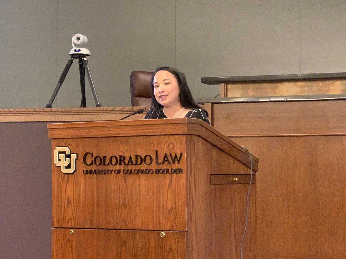


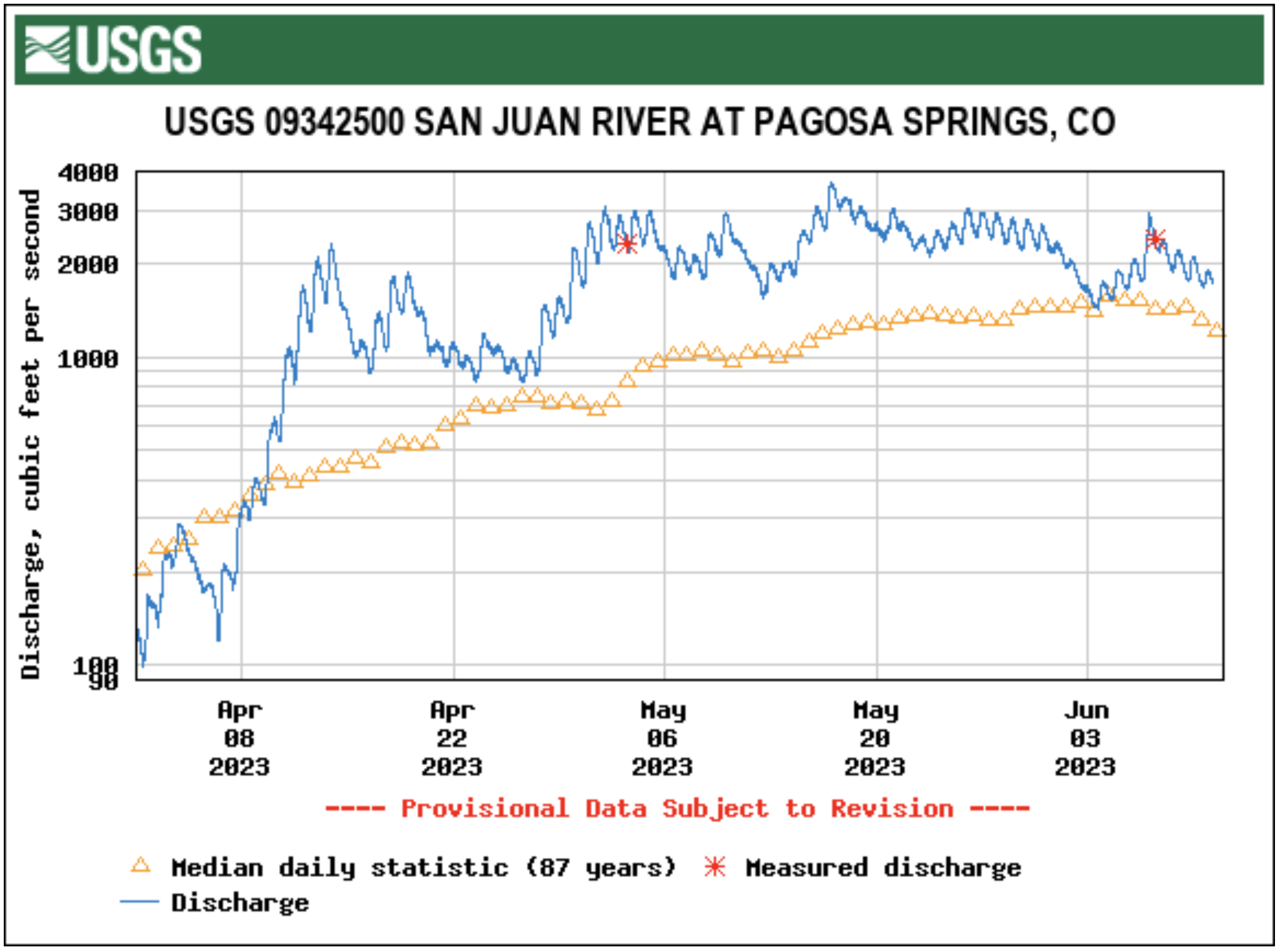

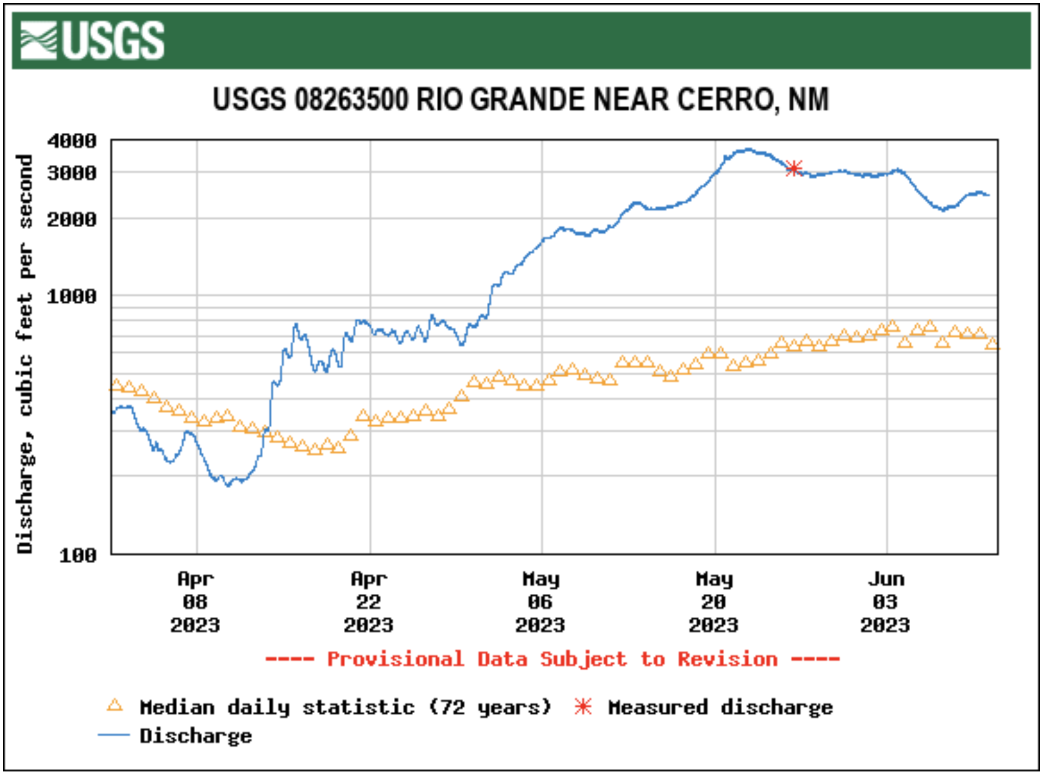
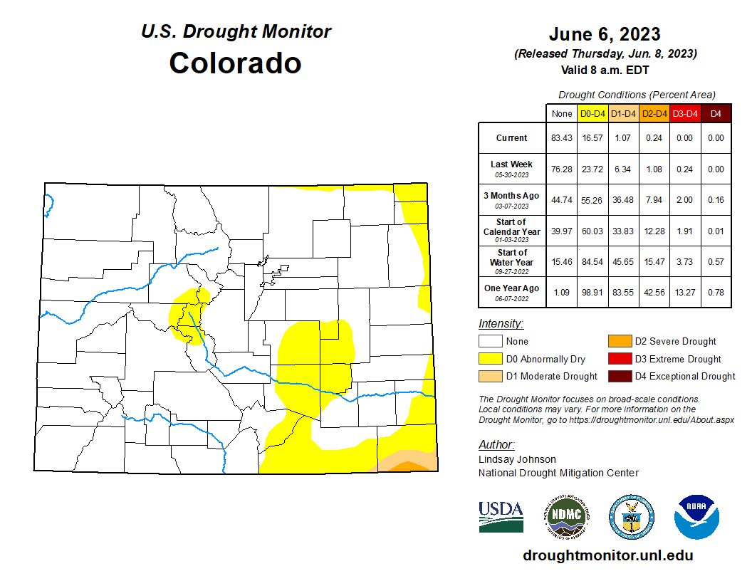


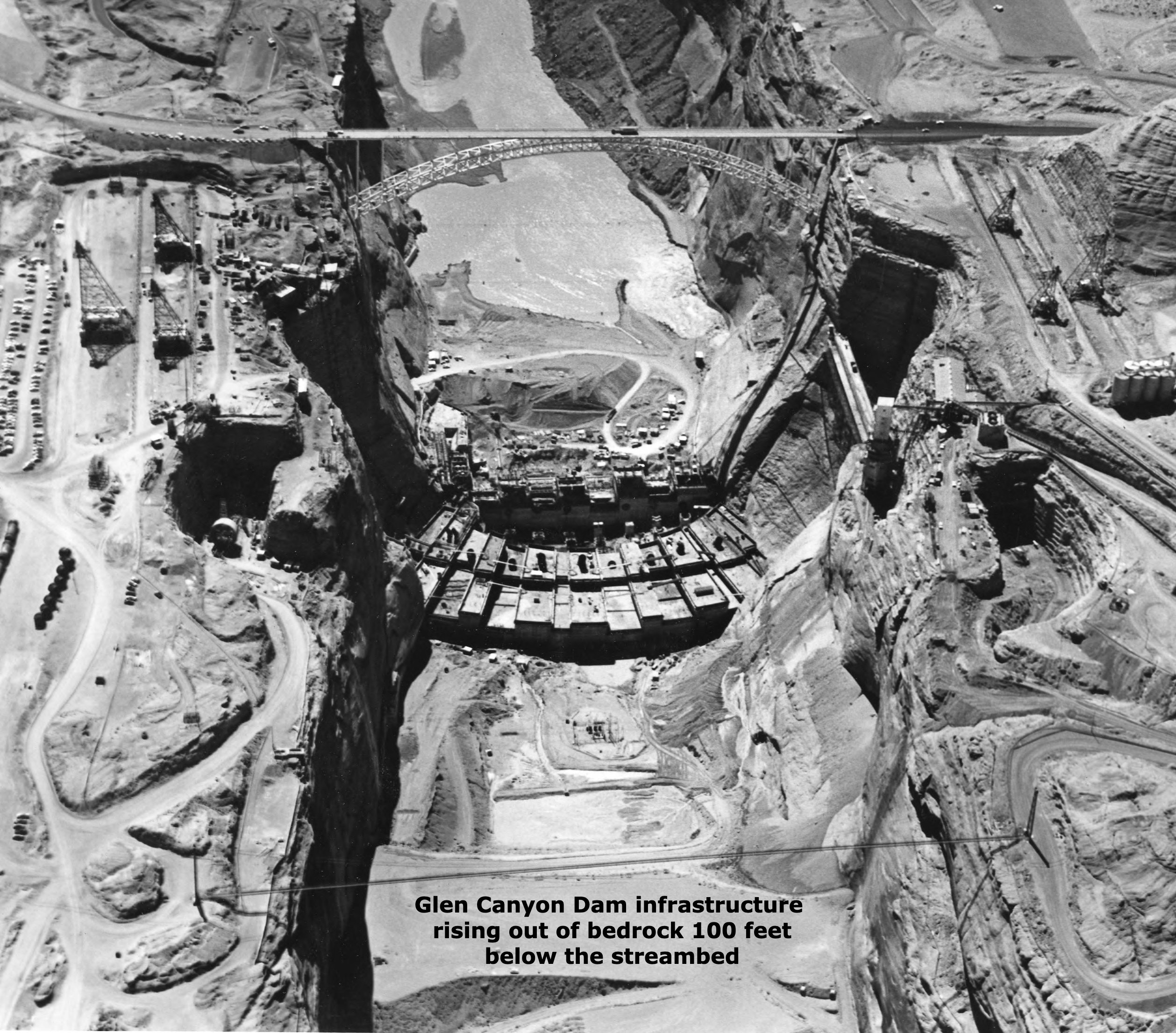


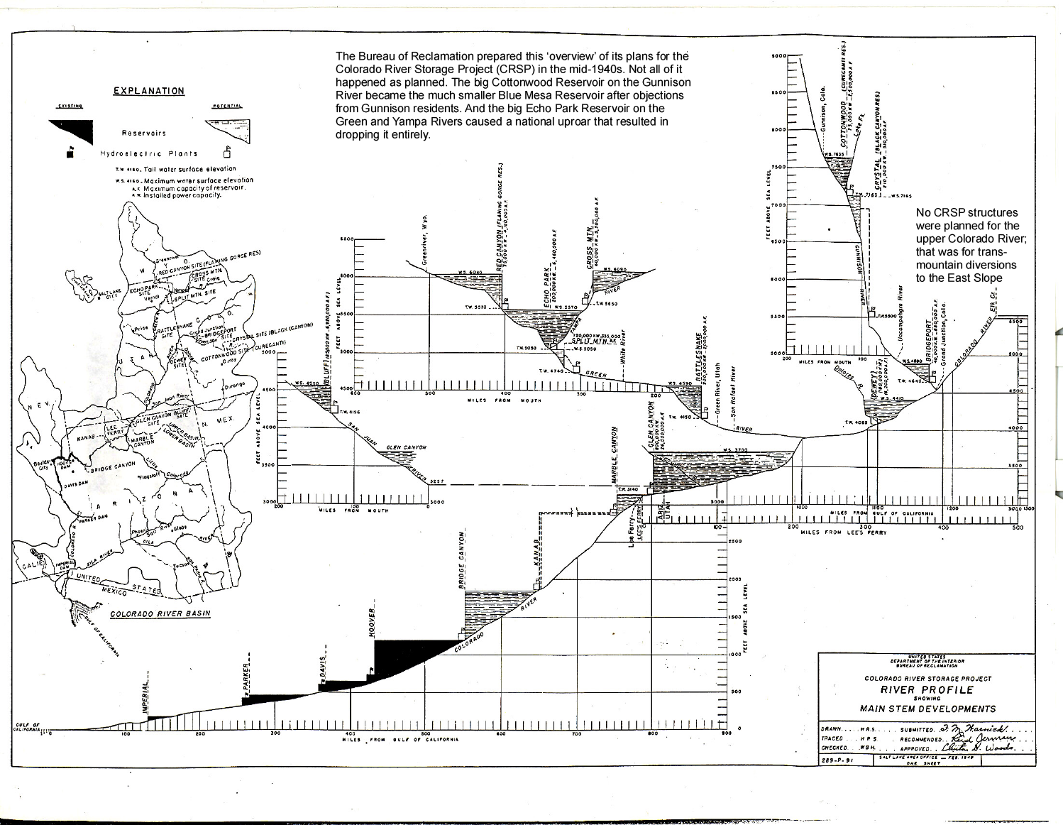


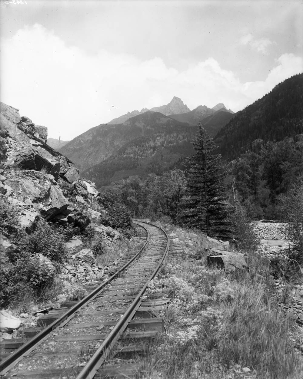


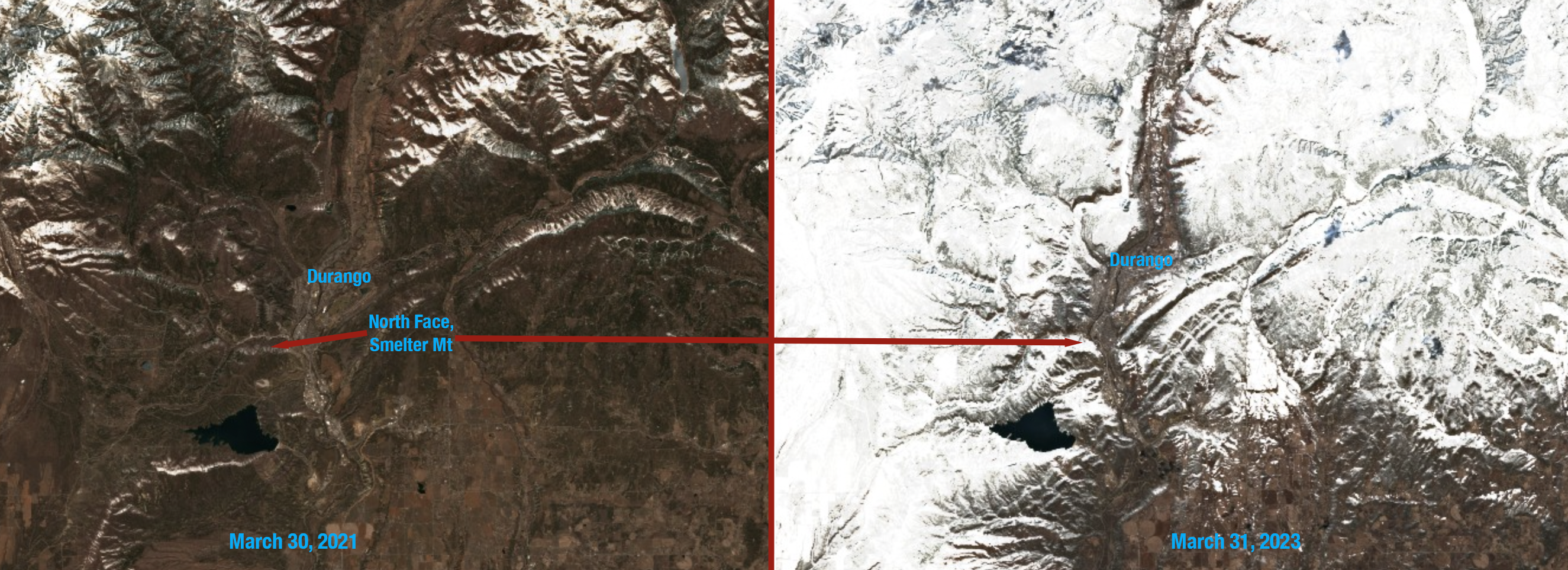
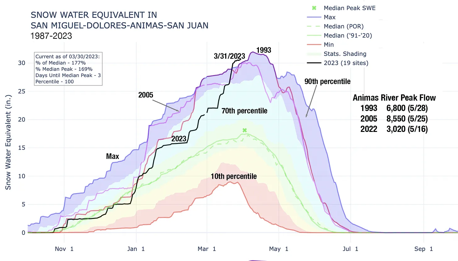

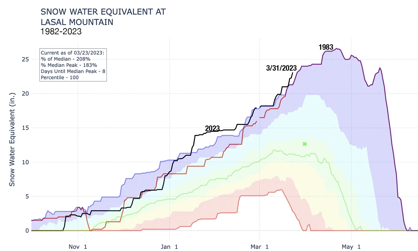

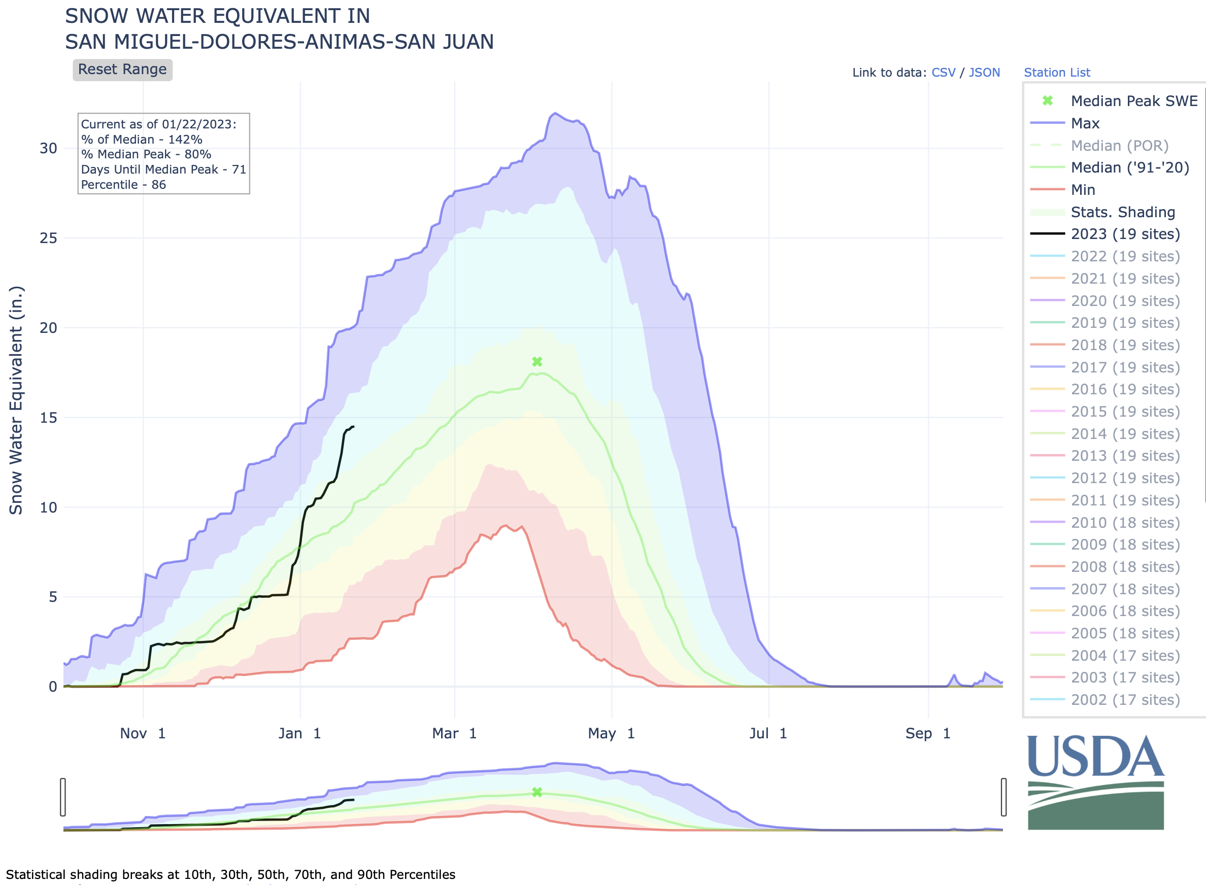


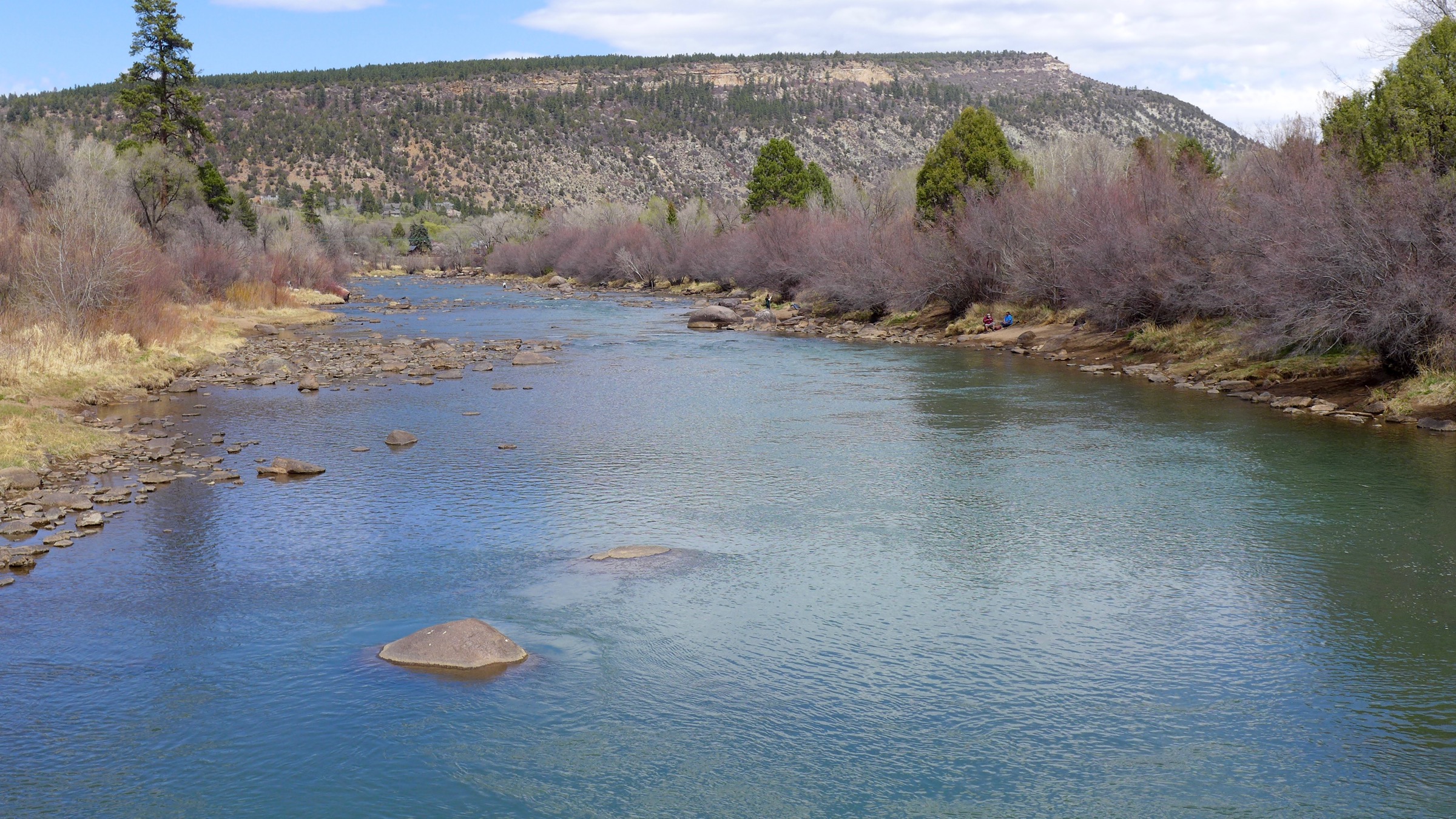


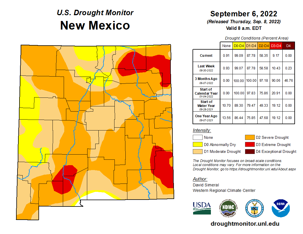


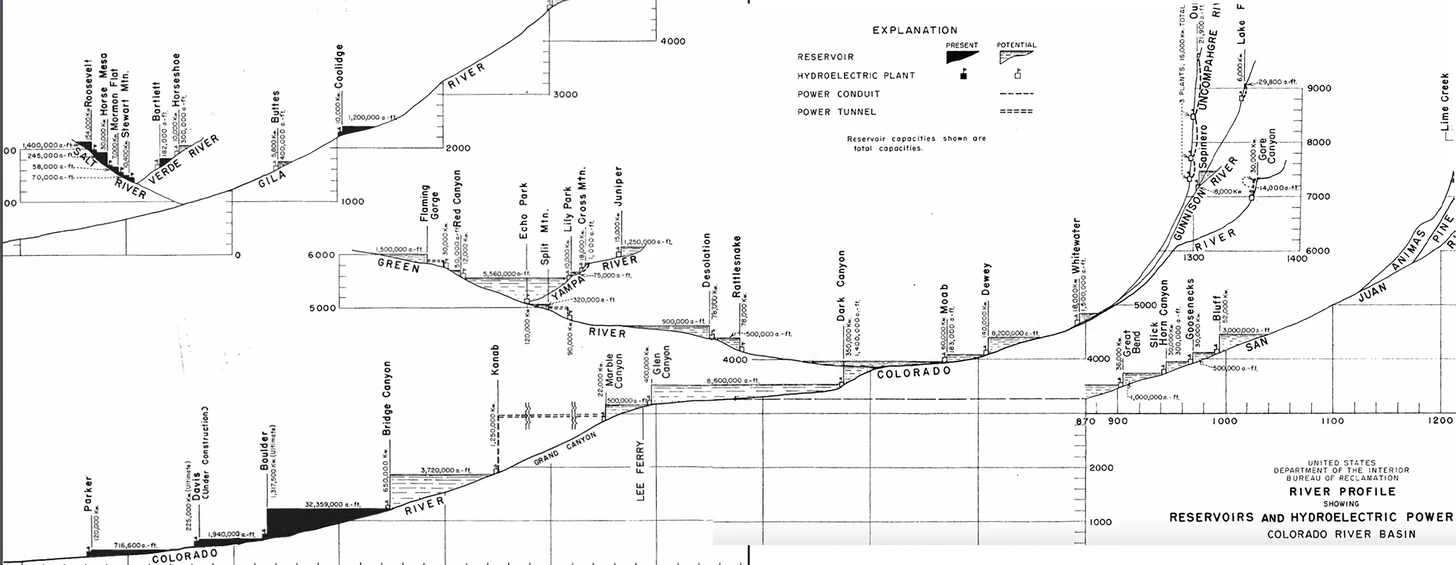

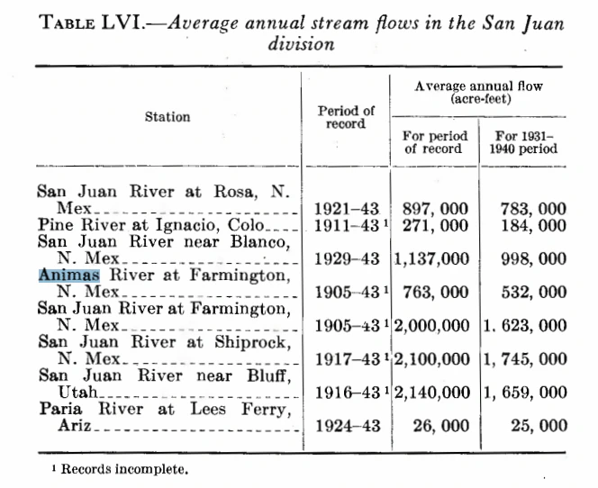


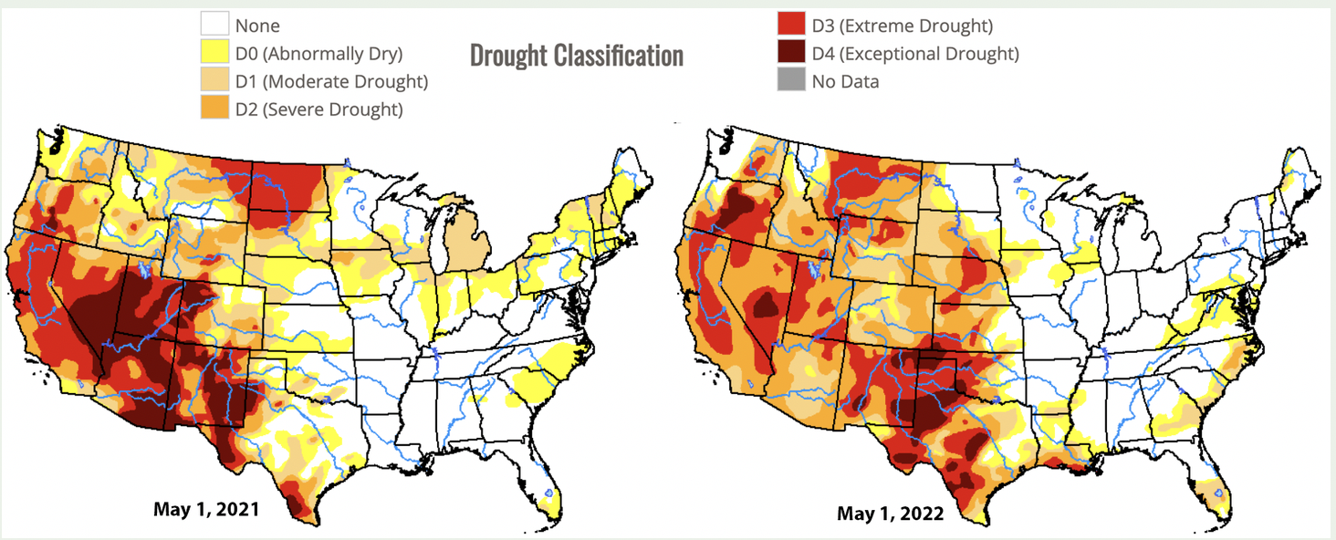

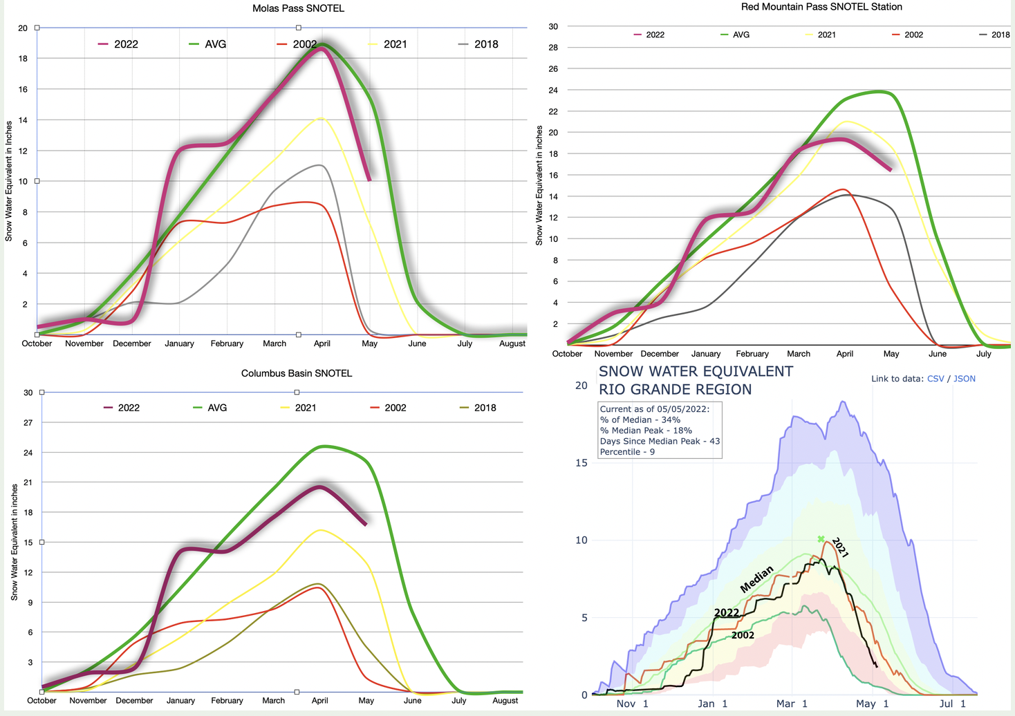
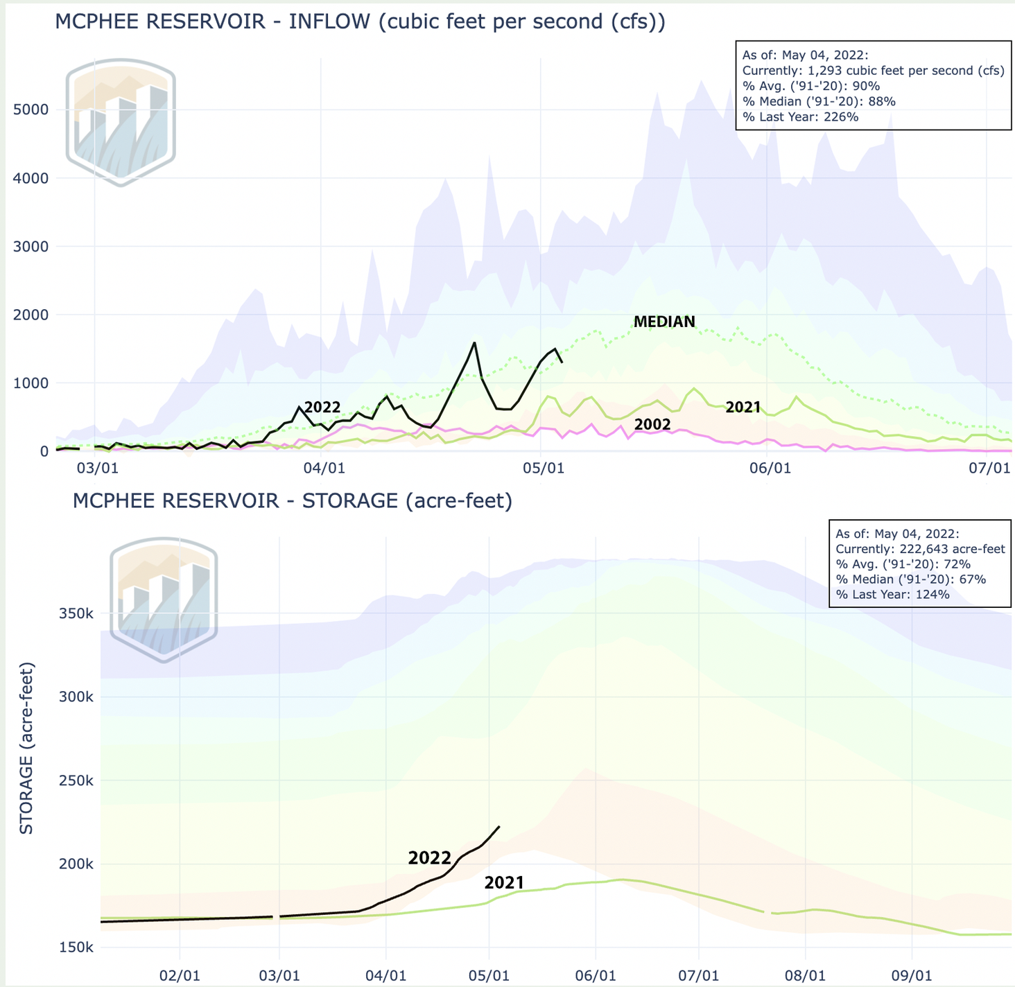


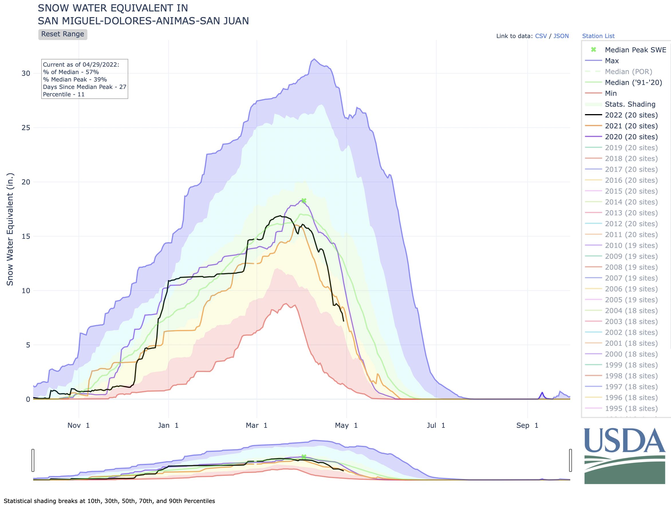
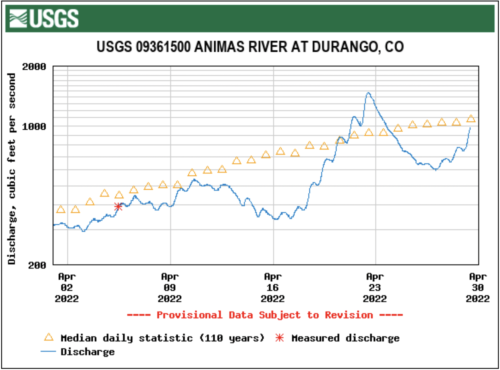


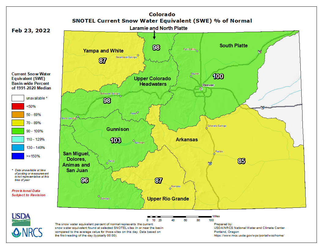
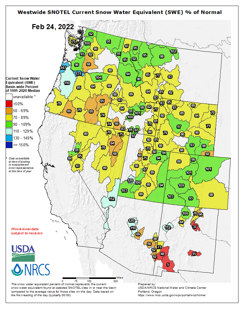
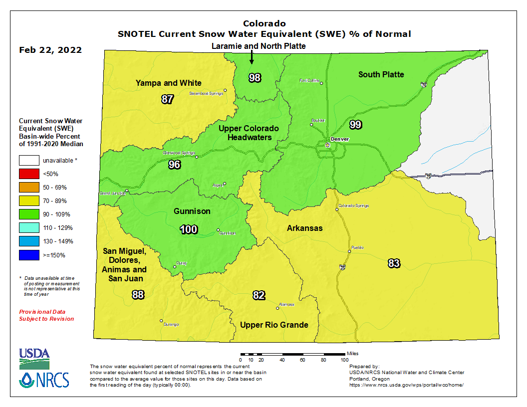
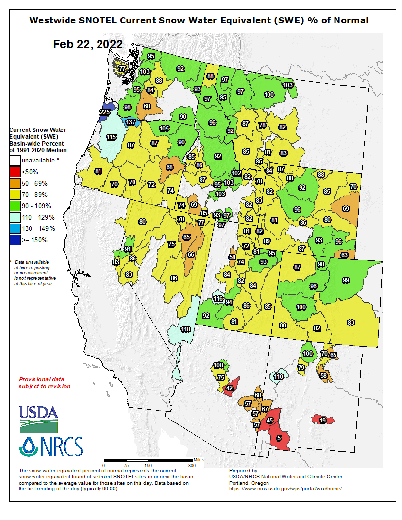
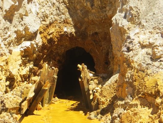

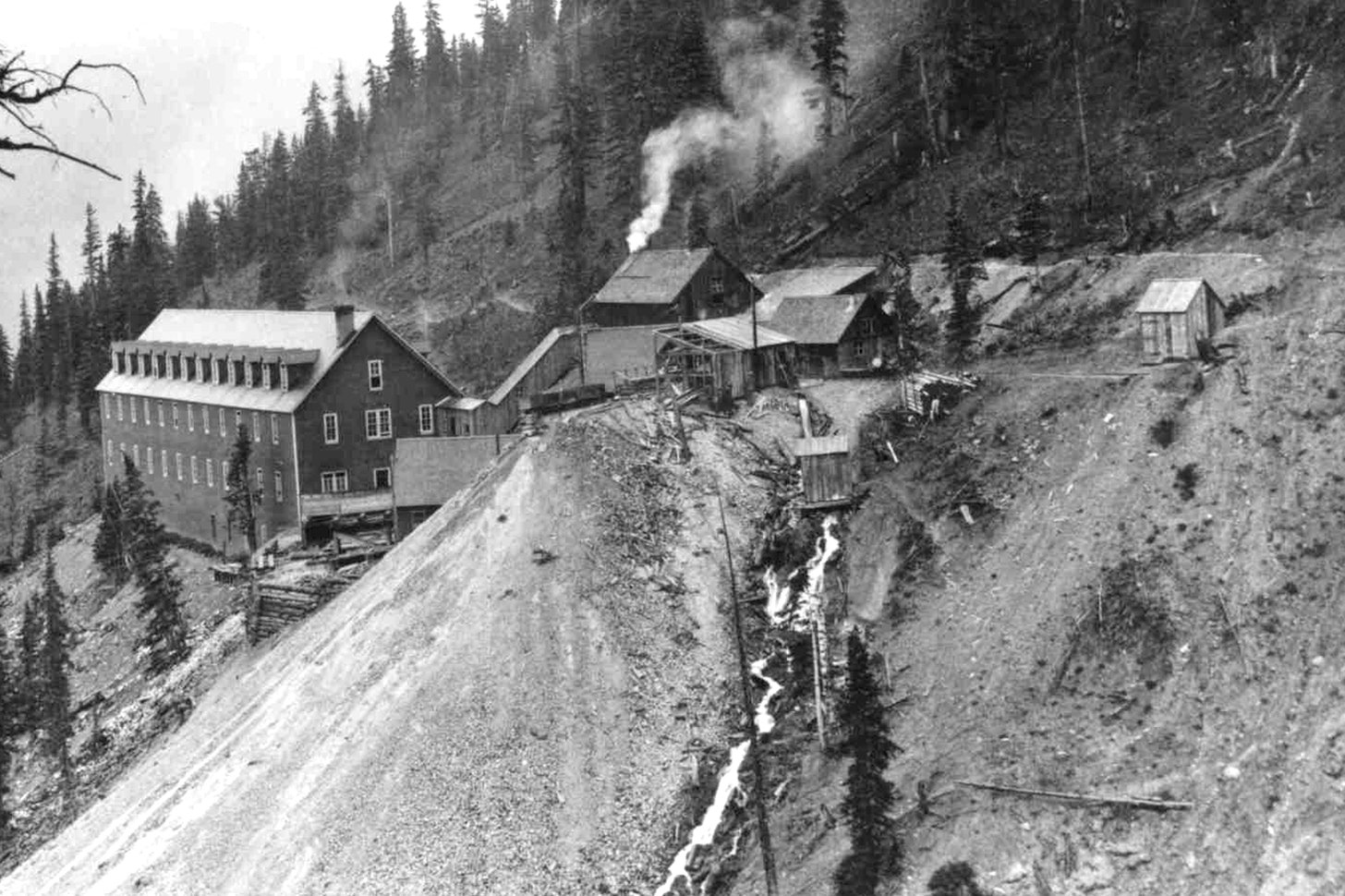

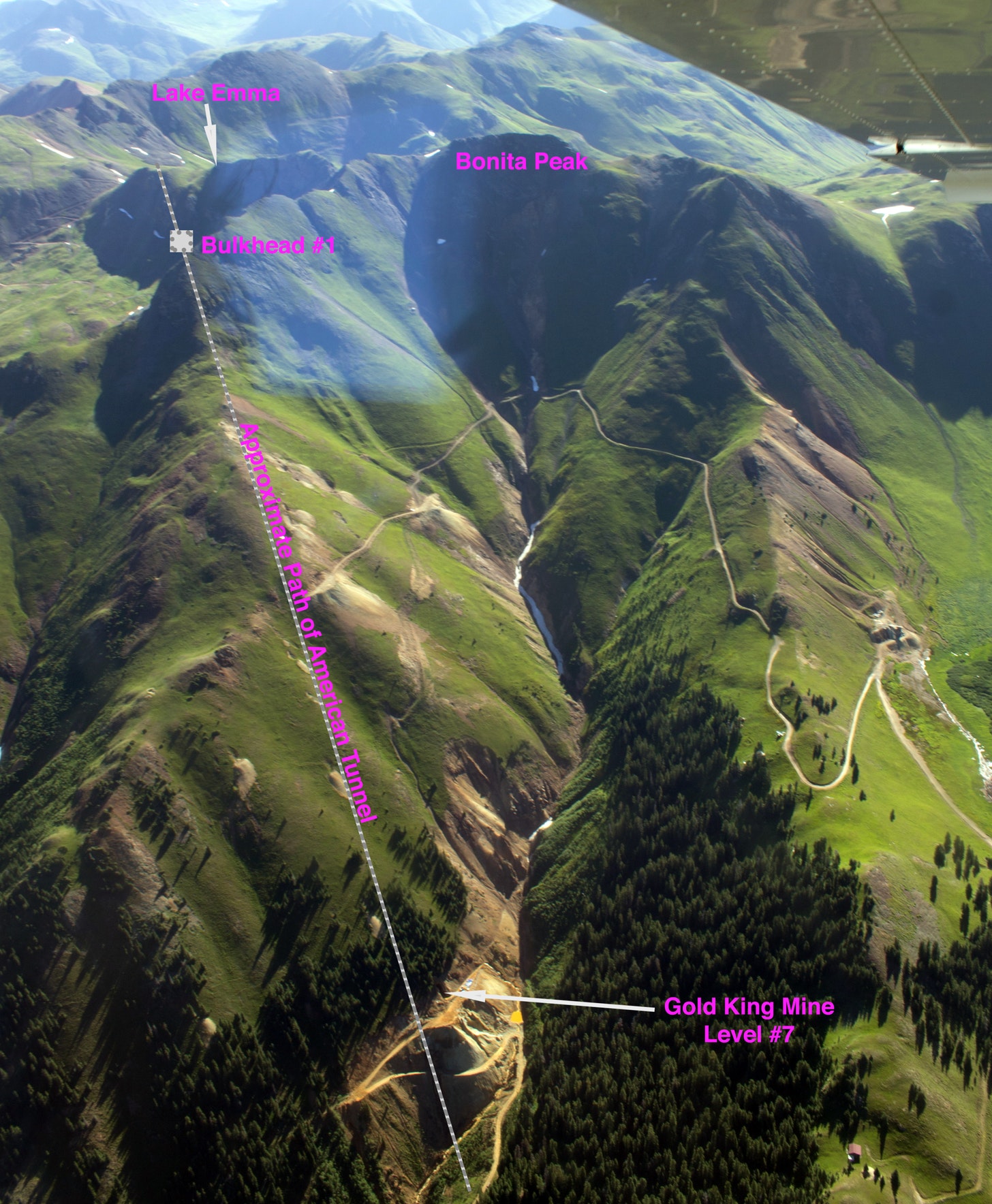
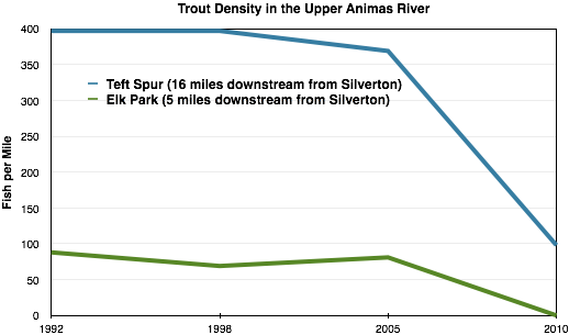


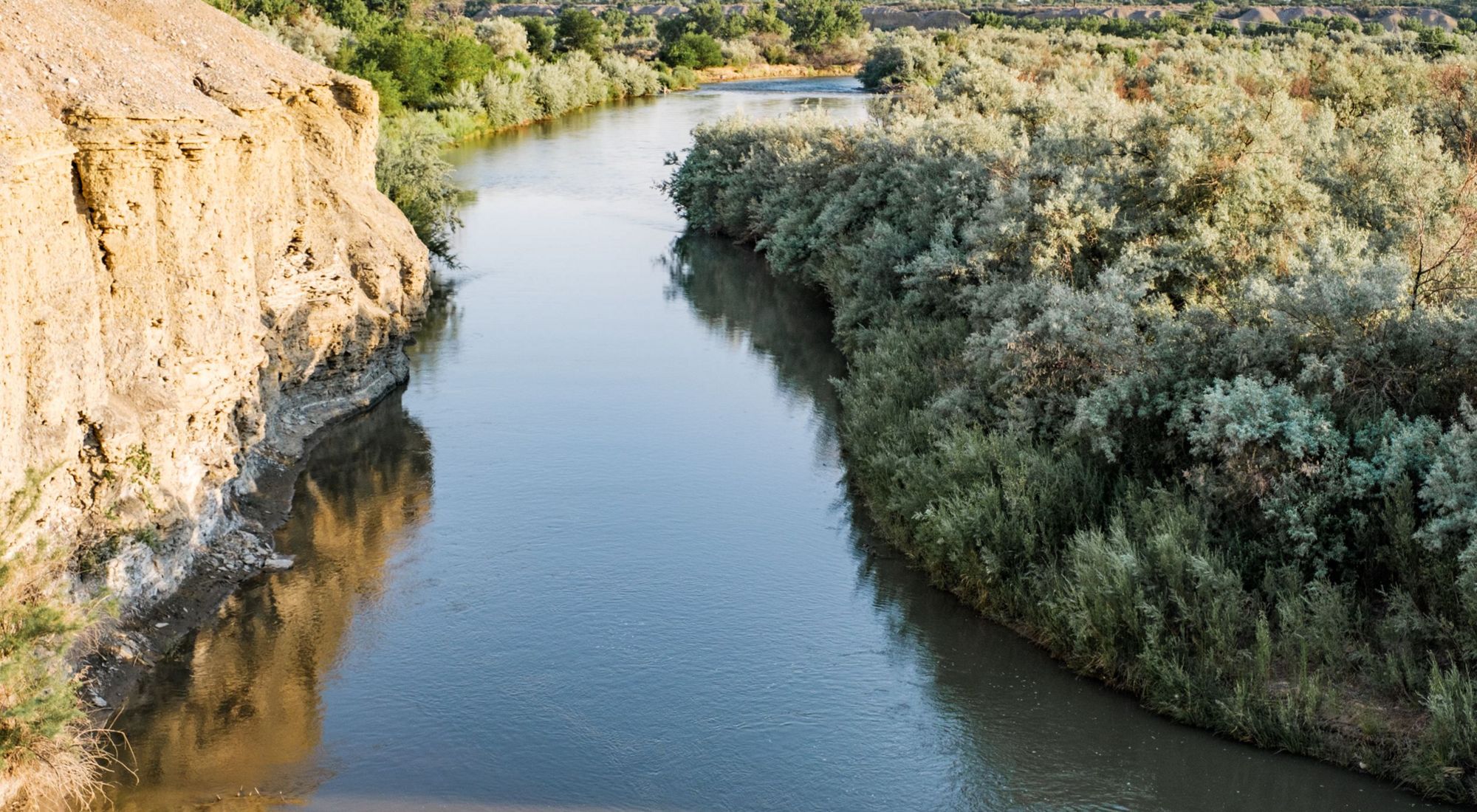
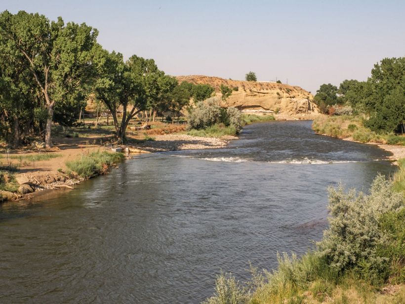

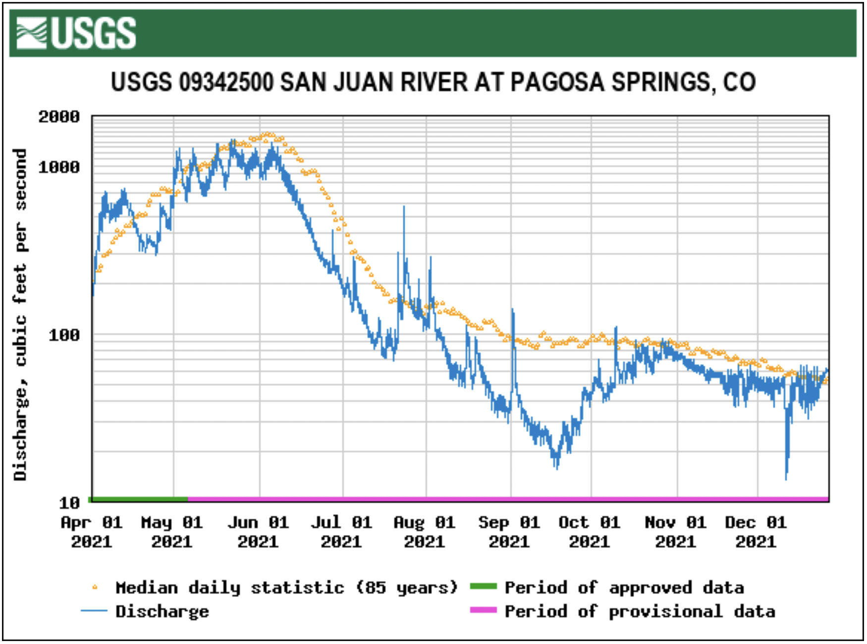

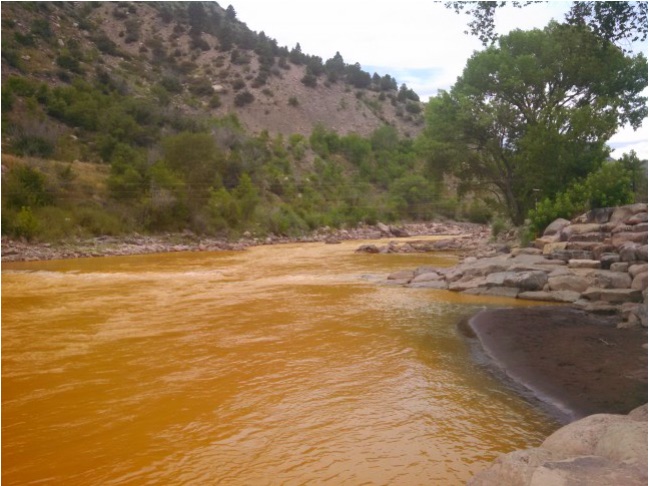


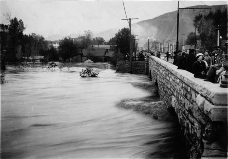

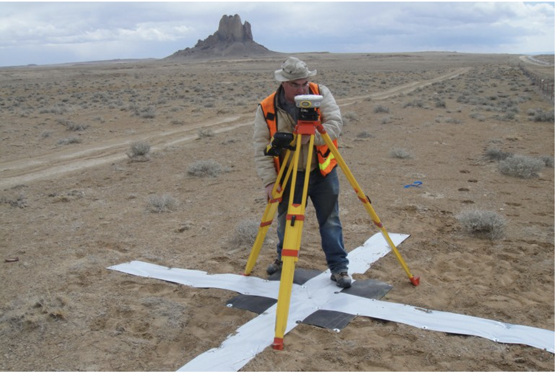