
Colorado prepares for launch of water contribution program — The #PagosaSprings Sun #SanJuanRiver #ColoradoRiver #COriver #aridification

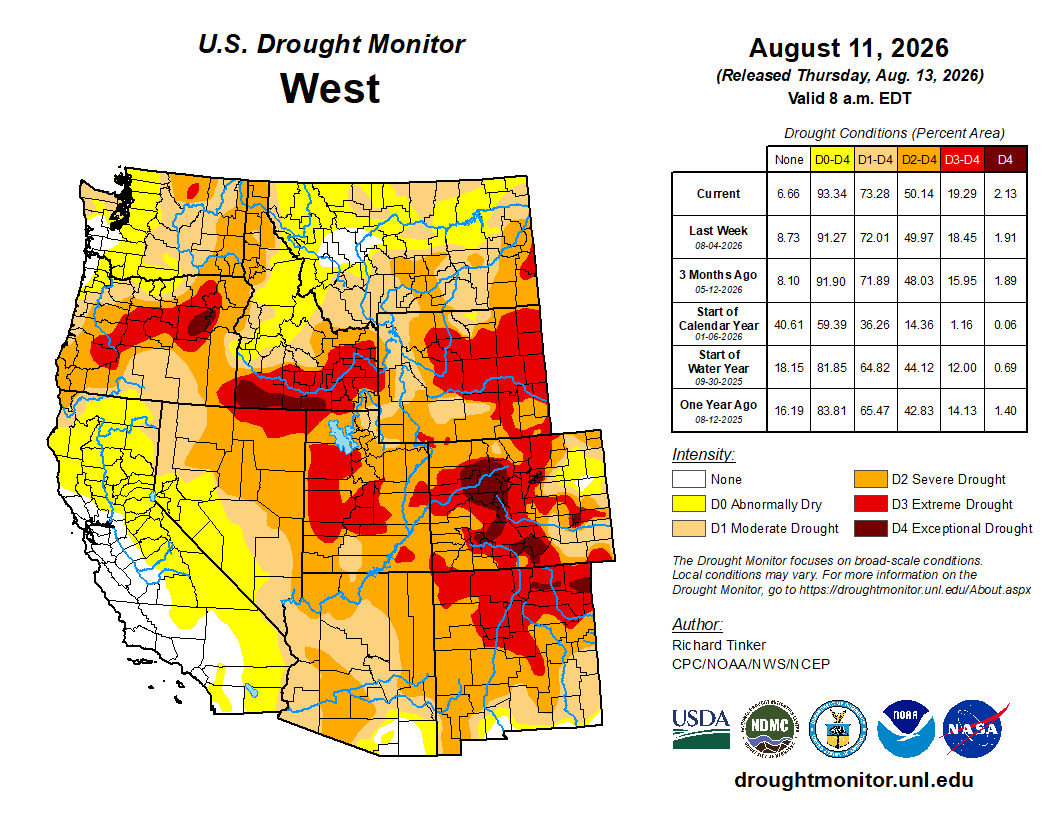
West Drought Monitor map August 11, 2026.

Click the link to read the article on the Pagosa Springs Sun website (Josh Pike). Here’s an excerpt:

August 12, 2026

Tensions about water management are high on the Colorado River, even as water levels in reservoirs like Lake Mead drop to record lows and the west faces severe drought conditions…On July 31, the federal Bureau of Reclamation released a final environmental impact statement which outlines a potential framework for management of the river between 2027 and 2036. This framework would include mandatory water use cuts of up to a combined 3 million acre-feet per year for the lower basin states of California, Nevada and Arizona while seeking 200,000 acre feet in voluntary reductions from the upper basin states of Colorado, New Mexico, Utah and Wyoming. The impact statement and the associated National Environmental Policy Act (NEPA) decision-making process still leave an opportunity for the states on the Colorado River to reach their own agreement about future water use…

Colorado is introducing a new near-term water contribution program designed to take advantage of federal funding to encourage voluntary, compensated reductions in Colorado River water use. At a webinar on Aug. 6, Amy Ostdiek, section chief for the Colorado Water Conservation Board (CWCB) interstate, federal and water information section, explained that this program is one of several parallel activities that the state is undertaking alongside the ongoing NEPA process. She explained that the Bureau of Reclamation has announced that $100 million in funding will be available to support the upper basin states in establishing water contribution programs that will provide “water that but for these actions would not be there” to the Colorado River. She noted that funding would likely support about two years of a program, based on previous project costs, and that, to participate and claim the funds, Colorado would need to act now to begin establishing a program. Ostdiek stated that establishing such a program would honor commitments the state has made in negotiations to making voluntary water use reductions and would show that “Colorado is committed to being part of the solution.”

Map of the San Juan River, a tributary of the Colorado River, in Arizona, Colorado, New Mexico and Utah, USA. Made using USGS National Map data. By Shannon1 – Own work, CC BY-SA 4.0, https://commons.wikimedia.org/w/index.php?curid=47456307

‘Pain and suffering’: What the feds’ Lake Powell proposal means for Utah and other Colorado River states — The Salt Lake Tribune #ColoradoRiver #COriver #aridification

Map of the Colorado River drainage basin, created using USGS data. By Shannon1 Creative Commons Attribution-Share Alike 4.0

Click the link to read the article on The Salt Lake Tribune website (Brooke Larsen). Here’s an excerpt:

August 12, 2026

After years of analysis and stalled negotiations, the federal government last month finally laid out its proposal for managing the Colorado River’s biggest reservoirs for the next decade. The Bureau of Reclamation still needs to release its final decision and an operating plan for the next two years. But its final environmental impact statement provides a framework for how it intends to manage parts of the Colorado River system under its control…

It still might not be enough in a drying West

The Colorado River Basin has been mired in drought for more than two decades, and research shows that area will likely only get warmer and drier. The question that really matters is how the new plan operates in a dry world, said Jack Schmidt, senior research scientist at Utah State University’s Center for Colorado River Studies. The document gives Reclamation flexibility to respond to an uncertain, but likely drier, river basin. It doesn’t solve all issues, though.  If drought conditions don’t improve, Reclamation said in its analysis that “even large and unprecedented reductions may be needed and may not be enough to stabilize storage” at Lake Powell and Lake Mead.

“The scary thing about all of this is that none of this solves the problem if the world keeps getting drier,” Schmidt said. “That should be taken as an enormous warning for the desperate need to reduce the impact of a warming planet and the drying of the Colorado River Basin.”

[…]

Reclamation’s framework sets a goal of 200,000 acre-feet of voluntary water conservation in Utah and other Upper Basin states — Colorado, New Mexico and Wyoming.  Gene Shawcroft, Utah’s Colorado River negotiator, said it will likely take Utah and its upstream neighbors three to five years to conserve that amount.

Local Motion: A record-low #BlueMesaReservoir — KVNF.org #GunnisonRiver

Low water at Blue Mesa Reservoir, along Colorado’s Gunnison River, on July 1, 2026. Photo: Mitch Tobin/The Water Desk.

Click the link to read the article on the KVNF website (Brody Wilson). Here’s an excerpt:

August 4, 2026

The largest reservoir in Colorado, Blue Mesa, is holding just over 240,000 acre-feet — “roughly about a third of the volume that we would typically expect to see in the reservoir in this time of year,” says Caleb Foy, senior water resources engineer at the Colorado River District. April-through-July inflow, 151,000 acre-feet, is the lowest unregulated inflow on record. This time of year, Blue Mesa is operated to maintain a minimum flow at the Whitewater gauge, far downstream, just above where the Gunnison joins the Colorado. A 2012 federal record of decision sets base-flow targets there — as low as 750 cubic feet per second, though June and July normally call for “upwards of just over 1,000 CFS at 1,050 CFS,” Foy says. Those flows exist to protect biology and recreation in the lower Gunnison, and endangered fish in the 18-mile reach of the Colorado below the confluence. This summer the Bureau of Reclamation, in consultation with the US Fish and Wildlife Service, other Gunnison Basin water users and the State of Colorado, “decided and agreed to lower the whitewater target down to 500 CFS.” It “isn’t certainly done lightly” Foy says: the cut preserves “nearly 500 acre-feet of storage per day” buying time against a Bureau forecast that Blue Mesa could drop below minimum power pool as early as October. Below that elevation the dam’s 86.4-megawatt plant (enough energy to supply at least 34,000 homes at full pool) — stops generating, and Foy says electrical output is already falling. Unlike Glen Canyon Dam, he is “not aware of any concerns” about operating below power pool.

Map of the Gunnison River drainage basin in Colorado, USA. Made using public domain USGS data. By Shannon1 – Own work, CC BY-SA 4.0, https://commons.wikimedia.org/w/index.php?curid=69257550