Click the link to read the article on The Land Desk website (Jonathan P. Thompson):
August 25, 2026
THE NEWS: The U.S. Interior Department on Friday handed down the operating guidelines for the Colorado River for the next two years, while also finalizing the 10-year decision framework that will guide these plans. And on Monday, Nevada filed a lawsuit challenging both the framework and operating plan, saying that potential shortages required by the plan could cause “cause devastating environmental, socioeconomic, and health and human safety impacts to southern Nevada and its citizens.”
THE CONTEXT: Interior, i.e. the Bureau of Reclamation, did two things. The first was to hand down a record of decision on the framework that will guide operating plans for the next decade, which I wrote about here, so I’ll skip the details this time.
Feds release Colorado River plan, and no one’s very happy about it — Jonathan P. Thompson
They also released a more specific plan for the 2027 and 2028 operating years. In the new plan, the feds affirm their commitment to “defending” minimum power pool in Lake Powell, or a reservoir surface elevation of 3,490 feet. When the water falls below this level, water can no longer be released via the penstocks and hydropower turbines, so it must all go through the lower river outlet works, which weren’t designed for sustained use.
Notably, Reclamation plans to do this by “initially seeking to maintain a minimum elevation of 3,510 feet. This provides an operational buffer and provides additional flexibility in recognition of the operational risks associated with sustained operations below elevation 3,490 feet … .”
The current elevation is 3,518 feet, meaning it could reach that upper buffer zone of 3,510 feet in October if current levels of decline continue.
To prevent it from falling any further, Reclamation would cut back releases from Glen Canyon Dam, which in turn would cut flows through the Grand Canyon and into Lake Mead, which would pull down Mead’s levels and trigger mandatory cuts for the Lower Basin users. Under the new operating plan so far, these cuts aren’t as onerous as many feared, and actually match up with what the Lower Basin had proposed to do voluntarily. The deets:
- The Lower Basin would receive 6.25 million acre-feet from the Colorado River, or 1.25 MAF below the Colorado River Compact’s allotment of 7.5 MAF.
- Arizona would receive 2.04 MAF; California 3.96 MAF; and Nevada 250,000 AF.
- This means Arizona would take a 760,000 AF cut; Nevada a 50,000 AF cut; and California a 440,000 AF cut.
Arizona takes the largest cut by percentage and volume because the Central Arizona Project, which delivers most of the state’s Colorado River water, has junior water rights to other big users on the river.
But if reservoir levels continue to drop, then Reclamation could impose further cuts on the Lower Basin, potentially slashing Nevada’s water deliveries by as much as 213,556 acre-feet, or about 71% of its total entitlement of 300,000 acre-feet. This would be truly disastrous for the Las Vegas metro area, which relies on the Colorado River for about 90% of its water. And it’s not like there are a bunch of alfalfa fields the city could “buy and dry” for the water rights.
The Southern Nevada Water Authority has managed to cut overall water consumptionover the last three decades, even as the population has soared, through system-wide efficiencies, incentives, tearing up ornamental grass, water recycling, and extra fees for water gluttons. Las Vegas still has room to conserve, but as Western water scholar John Fleck put it, there “is an absurdity to a plan that would require Las Vegas to cut 71%. That’s existential.”
Even more astonishing than the fact that the federal government is considering virtually drying up one of the Southwest’s major metropolises is their justification for doing so: To protect Glen Canyon Dam and keep it producing hydropower, even at greatly diminished levels, and — though it’s not stated — to keep lake-based recreation somewhat viable.
Glen Canyon Dam hydropower: What’s it good for? — Jonathan P. Thompson
You have to remember that when the feds vow to defend the 3,500-foot level at Lake Powell, and when they refuse to even consider re-engineering Glen Canyon Dam to allow for releases at lower levels, either by rebuilding the outlet tubes or tunneling a bypass around the dam, they are also saying they are going to trap more than 4 million acre-feet of water behind the dam that could otherwise flow downstream into the Grand Canyon and Lake Mead. That’s enough water to fill Nevada’s entire allotment for more than 13 years that, instead, will be sitting in the reservoir and slowly evaporating.
Nevada’s lawsuit — which is against the federal government, not the Upper Basin states — alleges that the feds’ plan violates the Law of the River. It slams the plan for not explicitly calling for releasing more water from Upper Basin reservoirs to prop up Powell, does not require Upper Basin states to make any cuts, and fails to consider a long-term alternative or engineered solution alternative to address Glen Canyon’s infrastructure limitations. The plan also does not account for its potential impacts on hydropower production at Hoover Dam, which drops off steeply as reservoir levels decline (meaning that preserving power output at Glen Canyon could lead to a net reduction in combined output from the two dams).
Save the Colorado, a river advocacy group, came out in support of Nevada’s lawsuit in a written statement. “Las Vegas has one of the best water conservation programs in the entire U.S.,” said Gary Wockner, the group’s executive director. “Penalizing Las Vegas for water use is like penalizing an obese person who lost a lot of weight taking GLP1s.”
A Colorado River glossary and primer — Jonathan P. Thompson
🌵 Public Lands 🌲
Rough Times at the national parks these days. In Bryce Canyon, a sudden thunderstorm left visitors stranded on trails and requiring rescue, with two of them transported to a hospital for hypothermia. It also unleashed some serious flash flooding. In Zion National Park, a rockslide narrowly missed a shuttle bus and forced the closure of a portion of the Zion Canyon Scenic Drive. And in Canyonlands, officials were searching for a missing individual in Horseshoe Canyon, a remote area north of the park’s Maze district. Temperatures in the area were in the 90s. In Death Valley, a French tourist died after his car got stuck in the mud on a remote road in 116° F heat.
The video below shows flooding near Tropic, Utah, downstream from Bryce Canyon National Park. Source: Garfield County Sheriff.
In May, I wrote about how climate change and aridification and a shrinking Lake Powell were coming for the Bullfrog Marina, on the northwest side of the reservoir. The water was simply getting too low for the marina to remain viable, so they were planning on moving it across the reservoir to Halls Crossing Marina.
At the time, it was not yet clear how lower water levels and the marina’s removal might affect visitation to the remote area. Now preliminary numbers are in:
- 67,277: Total recreation visitors to the Bullfrog District of Glen Canyon National Recreation Area, January through July 2025
- 44,206: Total recreation visitors to the Bullfrog District, January through July 2026.
That’s a decrease of over 23,000 visits, or a 34% drop. Even more dramatic is the drop in overnight stays in July, from over 47,000 in 2025 to just 17,000 in 2026. Then did folks make the long drive over to Halls Crossing, instead? It appears that some of them may have once the marina was moved, but overall this year visitation is also down on the northeast side of the reservoir.
- 18,023: Total recreation visitors to the Halls Crossing District of Glen Canyon National Recreation Area, January through July 2025.
- 15,099: Total recreation visitors to the Halls Crossing District, January through July 2026.
That’s a decrease of 2,944 visits, or a 19% drop. This may not all be related directly to the dropping lake levels. Horseshoe Bend, which is in Glen Canyon National Recreation Area but downstream from the reservoir, has also seen a significant drop off in visitors this spring and summer. In a future dispatch I’ll take a closer look at tourism numbers in general to get a better sense of how widespread the declines are.
Climate change comes for a Lake Powell marina — Jonathan P. Thompson
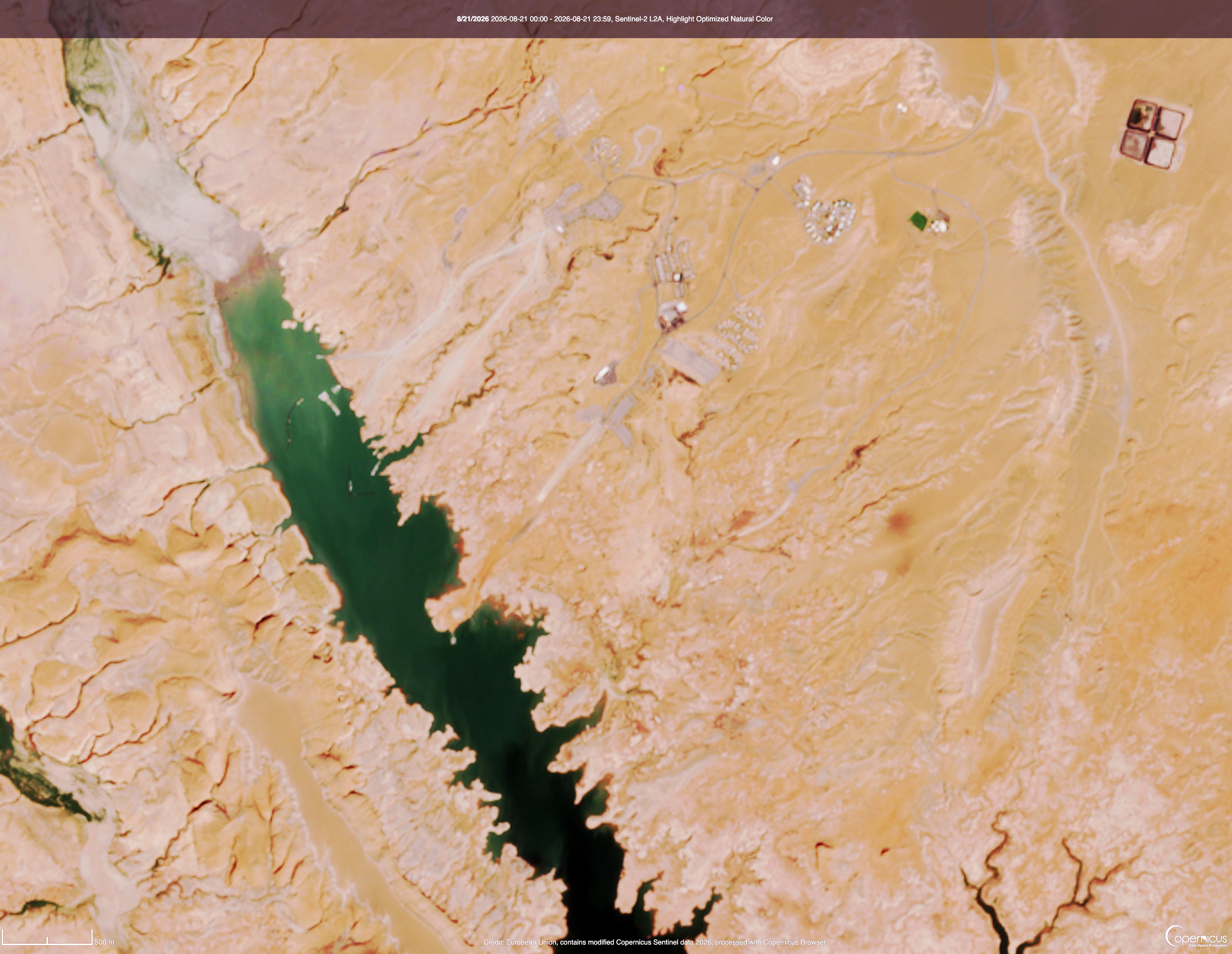
And now for the images showing Bullfrog with the marina, and without. The first image is from August 2024, when the reservoir’s surface elevation was at about 3,580 feet. The marina was still there, and the boat ramps still made it all the way to the water. The second image is from August 2026, with a surface level of just over 3,518 feet. Look closely and you’ll see the marina is gone, and the ramps are high and dry.