Water markets, prior appropriation

Flood irrigation in the Arkansas Valley via Greg Hobbs

From Water Deeply (Mark Squillace):

AS WESTERN STATES grapple with the best way to allocate dwindling water resources to meet multiple needs, water markets have emerged as one tool. But the idea is not without critics, such as Gary Wockner, who wrote a recent op-ed for Water Deeply about his skepticism that water markets will protect Western rivers.

Wockner raises three concerns with water markets: They commodify nature, there’s a lack of information about how much water they can really save and they skew funding to larger advocacy groups at the expense of others.

I see things differently.

Water markets don’t commodify nature. Rather, it is the prior appropriation system of “first in time, first in right” used through much of the West that gives private water users vested property rights in water. That is the root cause of this problem. It is entirely fair to criticize the prior appropriation system and if we could do it over I would advocate for a temporal permit system that protects the public interest in water from the outset and allows for periodic adjustments to these water permits as new information becomes available as to how to better protect the public interest in water resources. But that is not the world that we live in and it is unrealistic to think that will change – at least in the short term.

When it comes to information, we know enough already to show that the potential for marketing is vast. Current law – not lack of information – is the main obstacle to moving water efficiently. I have written on this topic and so perhaps have my own set of biases, but I believe that incentivizing crop switching, deficit irrigation and rotational fallowing by streamlining water transfers could yield vast quantities of water for new consumptive uses as well as non-consumptive ecological needs.

With regards to funding these projects, we should all be wary of the role that private foundations play in displacing the traditional role of government, ostensibly to promote the public good. And while we should be grateful for the positive work that private foundations have done to benefit our world, we must also acknowledge that private foundations have their own agendas, and their priorities may or may not reflect the public interest as that term might be defined by public agencies.

Nonetheless, so long as government fails or refuses to fund and address public needs adequately, foundations will have an important role to play. That does not mean that we must simply accept the choices that foundations make. On the contrary, we should demand that they be transparent and operate under standards that are fair. But we should judge the work of foundations on the merits and not be unduly suspicious of their motives. (To be clear, my work on water markets has not been funded by private foundations.)

This leads me to the broader point that Wockner raises about the need to reform our laws to protect “the rights of nature.” While I share a passion for protecting the ecological health of our water systems, I am skeptical about the prospects for an Ecuadorian-style constitutional provision.

The good news is we do not need it.

For the most part, we have the tools under our existing law that would allow us to protect the public values associated with water. We just need to use those tools in more creative and effective ways. Most prominently, in every state with positive water law (statutory and constitutional law), water is understood to be public property and, in most states, that translates into a trust responsibility on the part of the state to manage water for the benefit of the public.

Most states further demand that water resources be managed to protect the public interest. (The only state to have denied this responsibility is Colorado – the home state that Wockner and I share.)

Properly understood and properly applied, the public interest/public trust obligation offers the prospect that the communal values in water that we all share – to meet basic human needs, and to protect aesthetic, recreational and ecological needs – must be met first, before private rights are protected. Viewed in this light, and subject to these constraints, water markets are simply a mechanism for reallocating private water rights once public rights have been fully protected.

To be sure, many states have effectively ignored their obligation to manage water resources in the public interest. Other states have defined the public interest in ways that allow for balancing public values with private rights, as if they can be placed on an equal footing. This approach misconceives the nature of the public interest in water resources management. Only by first protecting those shared, communal values in water can we truly protect the public interest.

Rather than chasing a constitutional right of nature that seems unlikely to be realized, we should use the tools that we already have to rethink our approach to managing water resources. This will pose its own serious challenges; but because it is grounded in existing law, it stands a far greater chance of success. Let the hard work begin.

The Colorado River District’s take on Aspen’s conditional storage rights — @AspenJournalism

This map from 1984 is one of the few ever published that puts the Maroon and Castle creek reservoirs into the context of the city’s overall water system.

From Aspen Journalism (Brent Gardner-Smith):

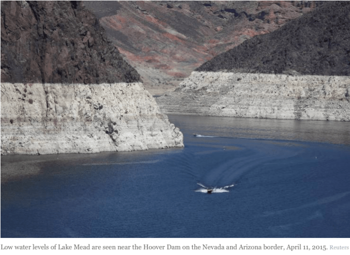
Given the ongoing discussion in Aspen about the city’s conditional water storage rights tied to two reservoirs on Castle and Maroon creeks, we thought it would be informative to interview Chris Treese, the external affairs manager of the Colorado River Water Conservation District, which works to protect Western Slope water supplies.

Treese oversees the River District’s legislative and regulatory governmental relations in Denver and Washington, D.C. Treese, who has a master’s degree in economics, describes his current job responsibilities “as everything you don’t want lawyers and engineers doing,” but he still spends much of his time discussing the finer points of existing and proposed water law.

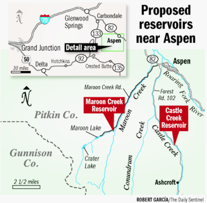
The city of Aspen filed two due diligence applications on Oct. 31 in Division 5 Water Court in Glenwood Springs, seeking to extend the conditional storage rights for Castle and Maroon creek reservoirs until 2022. The city originally filed for the rights in 1965. Ten opposers have filed statements of opposition in the two resulting diligence cases, and the next status conference among the parties is set for August 10, 2017.

We spoke with Treese on April 25 in the River District’s conference room in Glenwood Springs.

The resulting transcript has been edited for clarity.

BGS: Chris, thanks for doing this. It seems like the River District is well-positioned to shed some light on conditional water storage rights. The River District both holds conditional water rights and it also has walked away from conditional water rights, including on the Crystal River in 2013 which were part of the West Divide Project. And the River District is not involved in either of the two water court cases now underway in response to Aspen’s due diligence filings for the two reservoirs.

CT: Correct.

BGS: People have drawn parallels with the Crystal River rights that the River District abandoned, which were tied in part to two large dams, and the option, if you will, for Aspen to do the same. What’s similar and what’s different about the River District’s former rights on the Crystal and Aspen’s conditional storage rights on Castle and Maroon creeks?

CT: One of the similarities is they are both conditional water rights and simply by virtue of being conditional, they are what a conditional water right is, a placeholder in the priority system. But frankly, the differences leap to mind.

One difference is the ownership, as Aspen is a municipality, and municipalities have a different standard for diligence. The West Divide Project did not have a municipal purpose. It was originally, and remains, part of a federal project. And it was an out-of-basin diversion with its own impacts and concerns. I think those differences are significant.

The advantage, if you will, of having a municipal right, is you benefit from what’s known as the great and growing cities doctrine. In contrast to an agricultural or an industrial right with some fixed parameters around acreage or location and purpose of use, the courts have recognized that municipalities grow. And the responsibility of a municipal water provider is to provide water for present as well as the future.

As such municipalities have enjoyed almost unfettered ability to hold on to water rights and to perfect their conditional rights as part of their portfolio, either because they are growing or because they may grow. So the great and growing cities doctrine has provided an essentially unconstrained ability for municipalities to hold large quantities of water rights.

BGS: Wasn’t that latitude more closely defined by the two recent Supreme Court decisions known as the Pagosa decisions?

CT: Yes. So now you can’t say you will need the water in 100 years, but you can project need out 50 years. The Supreme Court found that 50 years is a reasonable planning horizon, and it recognizes that water projects take a long time to develop and water rights can be evermore critical during a period like 50 years. It also said that there has to be some common sense, some historical reality, to the projections over that 50-year period.

BGS: You mean you can’t just say Aspen’s population is going to from 7,000 to, say, 100,000 people, because, maybe it could.

CT: The applicant in the Pagosa cases – Pagosa Water and Sanitation District – were projecting 8% annual compounded growth for 100 years, and that was seen as overly aggressive by the court.

BGS: So there is a great and growing cities doctrine, which Aspen presumably can benefit from, but there’s also now some limitations placed on it from the Pagosa cases, primarily concerning reasonable growth projections.

CT: Right.

BGS: It strikes me that one of the similarities is the absurdist factor in both the Crystal River and the Maroon Creek situations. The dam forming Osgood Reservoir on the Crystal River would have flooded the town of Redstone, and Maroon Creek Reservoir requires a 155-foot-tall dam within view of the Maroon Bells. How should someone consider the relative impossibility of building such projects?

CT: One of the challenges to conditional water rights is that you have to prove diligence on the conditional right as filed. In the case of the Crystal it was a conditional water right for a reservoir that would have flooded a large part of the town of Redstone, if built exactly where and to the size as filed.

But the fact is that a water right, conditional or otherwise, can be changed, can be modified. It still would need to meet some of its basic purposes, but you could go into the water court and say, “There’s now a town of Redstone there and before there wasn’t a town of Redstone. And now the highway is there” and seek changes.

In fact, when the River District and its West Divide District partners looked at the Crystal conditional rights, we looked at how those conditional rights could be useful to the Crystal River valley, in contrast to their originally decreed purpose of transferring water out of the Crystal basin. But we knew we would still have to file diligence on the project as originally decreed.

BGS: So how flexible, how portable, are conditional water rights and their priority dates? There’s been ideas floated with the Castle and Maroon rights – that a smaller reservoir could be built, that they could be transferred to an underground storage facility on the city golf course, etc.

CT: What you can’t do is come in to a diligence filing and say, “We’ve talked about this.” That’s not diligence. You would have had to do more than talk about it, you would have had to at least study it.

BGS: Have studied moving it, for example?

CT: Yes, having studied moving it or using it for a different purpose at a different location. But it’s always up to the water court to find what’s adequate diligence, and they can look back at the original project and say, ” I think you’re talking about a new and different project. You need to file for a new water right.” That’s a risk.

BGS: Is there a threshold for what constitutes a new project?

CT: No.

BGS: Can we explore the standards of diligence? It seems there is a difference in what the water court might consider as diligence and what the average person might understand as diligence.

CT: There is a definition of diligence. It’s broad, and fairly non-specific in the legislation.

BGS: Is the diligence standard excused because you’re a municipality? Or does it still apply?

CT: It absolutely still applies. You must demonstrate to the satisfaction of the court that you are moving diligently toward development of the conditional water rights.

BGS: In the last clause of the city’s diligence application for the Maroon Creek Reservoir, it says, “applicant city of Aspen having demonstrated that it has steadily applied effort to complete the appropriation of the Maroon Creek reservoir conditional water right in a reasonably expedient and efficient matter under all the facts and circumstances … ” should be allowed to hang on to the rights for another six years.

So if someone has “steadily applied effort” to complete the appropriation of a conditional storage water right, does that means they’ve steadily applied effort towards storing the water in question?

CT: Yes.

BGS: Which also means they’re steadily applying effort toward building the structures, or dams, that would actually store the water in question?

CT: Well, the courts recognize that developing a reservoir is not as simple as getting a bunch of spray-painted shovels and having a ground-breaking ceremony. There are a lot of studies, and permits, and financing, and there’s a lot that goes into the early conditional period when planning for a reservoir.

BGS: But “steadily” applying effort means you’re moving towards actually storing the water some day, right?

CT: Yes.

BGS: It’s doesn’t mean you’re just hanging on to the water right for the sake of hanging on to the water right?

CT: Colorado water law prohibits speculation.

BGS: To be clear, if you’ve steadily applied effort to “complete the appropriation” of the conditional water right, then you’re moving towards storing the water. And if you are moving toward storing water, you need to be moving toward building a structure, a dam.

CT: Yes, right.

BGS: That’s what “complete the appropriation” ultimately means, right?

CT: Yes it does. Storage is clearly the end game, but diligence doesn’t specifically mean you’ve applied for a permit, or that you’ve hired bond counsel. There are a lot of early steps that may qualify as diligence.

BGS: Aspen, for example, does not claim it has been studying the reservoirs themselves, but instead it says that work on any part of integrated water management system counts as work on the whole system. So something like repairing pipes in downtown Aspen can count as steadily applying effort toward building the dams and reservoirs?

CT: Every water system is an integrated system in one form or another.

BGS: So what’s a citizen to make of that? In Aspen’s case, there appears to be little, if any, actual diligence on aspects of the projects that commonly comprise a feasibility study, such as water supply and demand studies, geological studies, construction analysis, permitting review, etc.

CT: I don’t know that.

BGS: Well, I’ve asked for such studies, and none have been forthcoming. What the city has told the court is that the reservoirs are part of their integrated water management system, they’ve been working on other parts of the system first, and work on one part of the system is work on all parts of the system.

That strikes me as a bit of a loophole, or at least a low bar. But how bulletproof of a legal argument is the integrated water management argument? Is that all the state requires? If you develop a reuse system at a wastewater plant, say, you can legitimately say you’ve also made progress on building two reservoirs?

CT: Nothing’s bulletproof, it’s up to the water court. And I’ll keep saying that. It’s to the satisfaction of the judge in water court. Or, actually, to the water referee and then, if necessary, the water court judge.

I can tell you the history of the integrated water system provision. The oil shale sector was the primary proponent for the amendment to that section of the law. And they said if they were working on other aspects of a system, such as a pump station and a pipeline, then those were physical manifestations of diligence toward developing their overall system.

If say, a pump station was for 20 cubic feet per second, but their conditional right allowed for 100 cfs, they didn’t wish to see the larger amount challenged, as they were simply working in a steady and progressive manner toward eventual development of the entire system and perfection of the conditional right.

BGS: So does a judge have to decide, in a claim of being in an integrated water management system, whether there’s actual progress being made in that claim?

CT: Yes. I think the court would ask, is there a reasonable nexus to the diligence application for the water right in question? Is one action leading to another? The other part of steady progress is that it cannot just be in the last week before you filed. You do have to show you were engaged in steady application of diligence efforts.

BGS: So even though it’s within the confines of an integrated water management system, there still has to be a nexus to the ultimate development of completing the appropriation.

CT: Yes.

BGS: So can Aspen claim it worked on one part of our system, even though it bares little relationship to the actual potential reservoirs, and still claim that as steady effort?

CT: That’s up to the water judge.

BGS: There is no clear standard?

CT: Well, in the diligence applications that I’m familiar with, you include all of the efforts that you feel are relevant. For example, when the River District files for diligence on conditional water rights, we often include details of our work on the recovery program for endangered fish, because it’s critical to the way the river system works today. It may not have a geographic nexus to the conditional filing in question, but it has a hydrologic nexus. And so we hope the water court recognizes our work is a necessary element to be able to ultimately develop the water right.

For example, if a city was going to build a reservoir someday they could look forward to having to go through a NEPA (National Environmental Policy Act) review. As such, they will need to study a range of alternative measures they could take, such as making sure they don’t have leaks, water conservation efforts, pricing, all of that.

You have to accept that water development is an enormous challenge, and you’re going to have to show that you’re using your existing supply to its maximum benefit and efficiency before seeking permits. So a water provider might include in an application for diligence the work done today on those types of activities, even though they don’t appear to be physically linked to the reservoirs. And they can count it as work toward a future reservoir, because it’s related.

BGS: Do you think the city should have been more actively studying its two potential reservoirs?

CT: You have to allow any conditional water right owner to decide what their own timing is that leads to development.

BGS: Okay, but is there any requirement for work to be done on a specific site or project basis? Even if you’re doing other stuff, do you still have to study the project at some basic level?

Because, in this case, it doesn’t appear Aspen has done much, or is doing much, investigating of the feasibility of the reservoirs themselves. And if the city thinks it might actually need the reservoirs, shouldn’t city officials be studying them?

CT: Not necessarily. You have to allow that Aspen has accepted from 1965 that these reservoirs may be necessary. And what they have asserted is that what they’re doing is working on the other elements of their integrated system that require immediate work, and in the succession of development and maintenance of their system, those are their priorities.

The fact that I filed for a reservoir, say, on Three Mile Creek, doesn’t mean that I have to keep drilling every six years to see what the soils look like on Three Mile Creek.

BGS: Yes, but should you have drilled once? No drilling, for example, has ever been done on the location of the Maroon Creek Reservoir, that I can find or that the city can produce.

CT: Eventually you will, but there are many other things required before eventual storage construction. Personally, I don’t know what the order is of when drilling or soils testing is required.

BGS: Wouldn’t you want to know what a drill test says about a key factor in a reservoir, which is where the bedrock is?

CT: Yes. You will.

BGS: Not now?

CT: Maybe not yet. This is probably not the first thing I need to know. Not everything is a study for fatal flaws, especially if you accept that they have a premise around their original filing that this is necessary and appropriate someday. That’s exactly what a conditional water right is.

BGS: It just strikes me as a profound lack of curiosity.

CT: I understand. I think you have a legitimate question as long as you’ll acknowledge that there is a whole series of studies, and hard and soft science steps, that have to be followed before you can get to application, let alone development. Then I think it’s a legitimate question.

BGS: So what’s the average person to make of the larger situation? The city can, in effect, say they are making progress but really, at least in terms of how most people might see the question, they are really not?

CT: Yes.

BGS: I understand then that someone can technically say in water court they are making progress, given the integrated system provision, but it seems to lack a certain integrity from a street corner or real-world perspective.

CT: Well, for example, for the Osgood Reservoir on the Crystal River, the River District didn’t feel we could tell the court “Rest assured, we’re not going to flood the town of Redstone” when the water right as decreed would have done so.

We were, in fact, looking at alternatives, but then it would no longer have been the West Divide project as conditionally decreed. And we would have admitted that to most anybody, except the court. Because if we weren’t going to flood the town of Redstone, by moving the storage right to a more acceptable location, it might be considered a different right by the court.

BGS: So that suggests there is an integrity gap in Aspen’s approach, because they are saying, in effect, “We don’t want to build the dam near Maroon Bells” and yet they are still pursuing the same rights that are tied to the dam.

CT: When you are filing for diligence, you’re filing to maintain the water right’s priority date. And it’s not a secret, and it’s not a lie, that the water right may in fact be developed someday in another fashion for another purpose in another location.

BGS: Well, then, how low are the state’s standards for diligence? If you simply say you’re making progress, and want to keep all your options open, does the court just say, “Okay, carry on.”

CT: Let me acknowledge that conditional water rights are typically not contested. You usually don’t have objectors in a diligence case. And until relatively recently, if a filing didn’t have an objector, including the state of Colorado or anyone else, water courts tended to say, “Nobody’s upset, so no harm, no foul. Continue. Your diligence application is approved.”

Now the bigger filings have had objectors. We’ve had objectors on the Western Slope from eastern Colorado for large filings that were senior to some of the junior aspects of their transmountain diversions. They have had a clear self-interest in attacking these conditional rights, because they would improve the seniority of their junior rights by removing the threat, if you will, of a senior conditional.

But most filings aren’t contested, and uncontested filings are generally approved by the court without much analysis. Admittedly, the court might take exception to that.

BGS: Switching gears, what is the harm in walking away from a water right?

CT: It depends. We maintained the rights on the Crystal because we thought storage in that basin could have been a significant benefit to western Colorado. And our choice to abandon those rights was not as simple as concluding we didn’t need storage there.

We were being challenged in court, and the challenge was to the entire West Divide project. And our partners in that project, the West Divide Water Conservancy District, still intended to pursue aspects of that project that are outside of the Crystal River drainage.

We didn’t want the tail – the potential dams on the Crystal – to wag the dog – the other parts of the project. So we looked at number one, the opposition and the risk to the other water rights outside of the Crystal River basin. And, two, we recognized that if, in the future we still wanted to pursue storage on the Crystal then a new junior storage right would accomplish largely the same goals as those senior rights associated with the conditional filing would have.

BGS: Okay, so the River District made a call to walk away from two large dams. But the city of Aspen seems to always pour cold water on that option by suggesting if they abandon them someone else is going to come in and claim them, and their decreed date of 1971, apparently.

CT: Impossible.

BGS: So if someone else comes in and claims a storage right on Castle and Maroon creeks, it’s going to have a new junior priority date? They can’t come in and claim a 1971 right?

CT: Correct.

BGS: And someone could always still come in and file for a new junior right, whether or not the city abandoned its rights?

CT: Yes, but it’s a very different water right if you’re behind a senior conditional right. And there is the “can and will” test. You may not be able to develop the new junior right if it’s in line behind a senior conditional right. It depends upon the hydrology and how much water is available to store during runoff.

BGS: So if by retaining a conditional senior storage right, you make it less likely that someone’s going to come in and file for a junior right, isn’t that an advantage for a senior rights holder, like Aspen, in this case? If so, that suggests there is value in just sitting, if you will, on a senior conditional right as a preemptive move against future interlopers.

CT: Aspen, or anyone else, may see a strategic value in that approach. But that’s not sufficient diligence. There were a number of people in the Crystal basin who were in favor of water development. Not in favor of flooding Redstone, but who were in favor of water development. And they saw our conditional water rights as a strategic card and said if we didn’t hang onto that water right, then someone like Denver Water could come in and file. But we never said that; we never saw that. It’s not a legitimate or feasible threat. Nor did we see it as a sufficient to present as diligence.

BGS: You mean you can’t protect your water rights unless you’re actually making progress towards completing the appropriation? You can’t just be doing it for strategic purposes?

CT: Correct. You have to be diligently moving toward development. Remember, though, that oil shale has largely maintained its water rights from the 1940s by researching oil shale development. Some would argue there’s no way that they’re moving toward development or perfection of those rights. But the courts so far largely have found that they are.

BGS: Ah, yes, it’s always the court’s call. But how unusual is it to have ten opposers, as Aspen does, in a diligence case? Doesn’t that change things?

CT: It’s certainly uncommon to have opposers in diligence cases. And it’s worth noting that while a city cannot hold onto water rights solely to suit their strategic priorities, opposers can challenge the city’s rights based on their own strategic priorities

BGS: In other words, as an opposer you don’t need to prove standing, you don’t have to show injury.

CT: Essentially right.

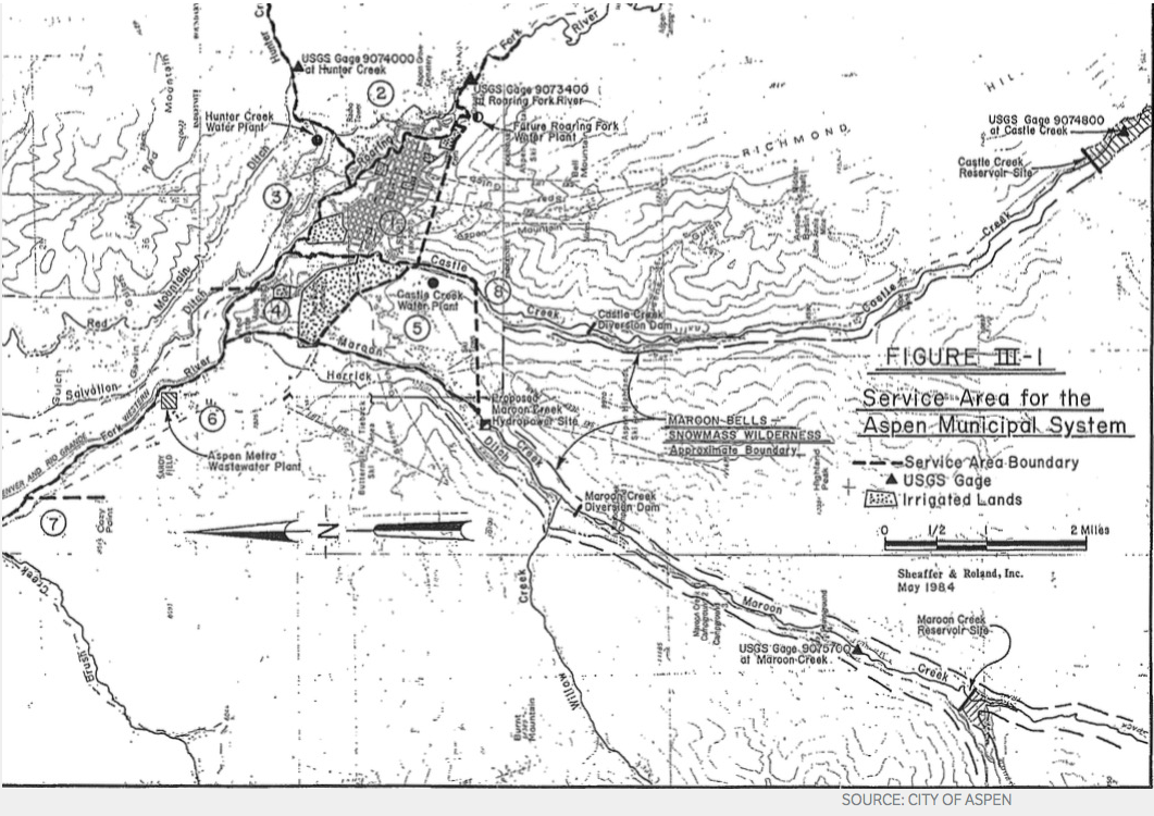
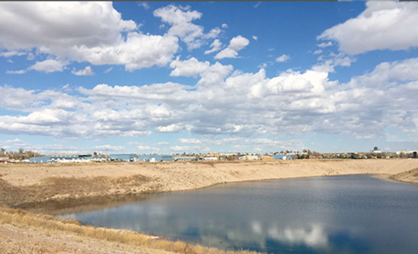
BGS: Another outstanding question I have is about storage. The Castle Creek Reservoir would hold 9,000 acre feet of water and the Maroon Creek Reservoir would hold about 4,500 acre feet.

And recently, Aspen City Manager Steve Barwick told the Pitkin County Healthy Rivers and Streams Board, and I quote, “All of this, this whole notion of how much water do we need and how much water do we need to store, and all of that, has been based upon very preliminary analysis. And now it’s time to tighten up the whole analysis and do a rational set of studies so we can have a rational discussion with the entire valley about what are we going to do here. How much storage do we need, and where do we want to put it?”

Given that, why is the city telling the state it needs 14,000 acre-feet of storage if they aren’t sure how much storage they need? How hard is it to determine how much storage a city needs? A recent raw water supply analysis from Wilson Water found the city could meet future needs without storage, even after aggressive climate change projections.

CT: I would suggest that it’s not particularly easy to look 50 years down the road and try to figure out exactly what your needs are going to be.

BGS: So, again, what should a citizen make about the duality in the situation, where the city is telling the state it’s making progress while telling citizen’s it’s the last thing they want to do?

CT: I will say I feel the city’s pain, because while they may not have any actual intent to build that size reservoir in that location, they apparently see a need and a purpose for additional storage. As we did on the Crystal. Were we going to flood the town of Redstone? Not in this day and age. We knew that. Could we admit that anywhere but the water court? Sure. But in the water court, that’s not what you’re able to do.

BGS: So does that speak to the failing of the water court? Or to an issue of integrity?

CT: You keep suggesting that this is an issue of integrity.

BGS: Well, I keep asking.

CT: I think the city recognizes the value, the purpose, and the benefit of storage at large. Storage of some size. Storage in their water supply planning.

BGS: Storage of some size, somewhere, at some point, in some location.

CT: Yes, and that’s what a conditional water right may provide. But it’s not a failing of the court, because it doesn’t, in fact, allow for unfettered flexibility. The court would likely reject a suggestion, say, that a conditional storage right on Castle Creek might be used on Hunter Creek.

BGS: But the city is studying and positioning various potential alternatives, suggesting the rights are quite portable and flexible.

CT: The conditional water right system does allow for movement. But it would likely have to have a junior right if moved too far.

BGS: But no one knows for sure until they go through the process? There’s no standard?

CT: Well there is a standard for that. If you go too far, say if you try to exchange that right to Hunter Creek, it’s going to end up being a new junior right.

BGS: So there’s generally limited flexibility?

CT: Yes. But you never know until you go through water court.

BGS: Can we discuss why the River District has not taken a position, or really, said anything, one way or the other, about Aspen’s conditional water rights? The district is not an opposer, so it apparently doesn’t oppose them, but it hasn’t said, for example, that they think those reservoirs might be valuable for any reason.

CT: Well, we’ve never been asked.

BGS: The city has not come to you? They’ve never consulted with you?

CT: No. Aspen has not asked for help.

BGS: Or sat down and asked you about your experiences on the Crystal?

CT: No. Nor do I find that odd that they didn’t. Montrose hasn’t, and Grand Junction hasn’t. Ute Water is working on developing and permitting storage on the Grand Mesa. They haven’t asked for our help. Others have. Eagle River and Water Sanitation asked for our help in putting together multi-party agreements that years ago resulted in the Eagle River memorandum of understanding, or MOU. Now we’re working on fulfillment of the MOU to develop joint-use, mutually beneficial East Slope-West Slope water.

BGS: Do you feel there’s any harm done if the city’s water rights are abandoned, from a Western Slope water rights perspective?

CT: We have not looked at them.

BGS: With respect, why not? It seems like something the River District would do.

CT: Well, this is what individual utilities do within our 15 county district. They develop their water rights.

BGS: But Aspen suggests there are threats from a Front Range bogeyman, and I wonder if you think a bogeyman is lurking, waiting for the city to give up its rights?

CT: We don’t see this as the bargaining chip that we need to, or have been asked to, help preserve. It’s a tool in the toolbox, perhaps, but we haven’t analyzed exactly how these water rights might be used in the ongoing poker game.

BGS: I’m trying to discern the significance of the River District’s neutrality and silence about the Castle and Maroon creek reservoirs.

CT: I find our position unremarkable. There are many entities that are pursuing diligence or perfection of their water rights. We have no interest in jumping into a situation that has already divided our shared constituents. And Aspen has not asked for our help in their diligence filing, or their studies. So we have no direct dog in this fight.

BGS: So, again, is there a downside to Aspen giving up the rights, as the River District did on the Crystal?

CT: I think it may be important to ask what the opposers are seeking. Are they concerned about a dam in that particular location? If the dam were somewhere else, would they have the same concerns? Are their concerns really about growth? Is the concern that Aspen has, or may have, a vision of its future, that is more crowded than some may accept? I don’t know the answer. Is it that Aspen has said that they want to maintain the instream flow rights? Is it the idea that storage can be used for meeting an instream flow, or enhancing an environmental benefit? What are their motivations? And perhaps most importantly, what happens if they succeed?

BGS: Well, fair enough. I’ll follow-up with the opposers, and they have articulated many of their concerns for the water court referee. But that’s why I asked you what harm the River District sees if the rights are abandoned. Apparently you don’t see any, which says something about the size of the bogeyman.

CT: What does Aspen see? Are there any competing conditional rights in between that if Aspen drops out, somebody moves up the line? If there’s an intervening conditional water right on the Roaring Fork, that would be pertinent.

These water rights may be a bar, or a deterrent, to another conditional rights that couldn’t be developed if these rights were senior. So I think it’s a legitimate inquiry as to whether, say, Pitkin County Healthy Rivers and Streams, has considered what the full implications are to not having these water rights. I don’t know the answer. I’m just saying it’s a reasonable question.

BGS: I agree it is a reasonable question. And a reasonable question to ask the River District, too.

CT: We haven’t looked at it.

BGS: Again, with respect, why not?

CT: Nobody’s asked us, nobody’s suggested it. It’s not a problem.

BGS: But isn’t that in your mission? I have to think that if the River District thought that if these rights were to go away it would harm the Western Slope, you would have said something.

CT: If we thought so yes, if we had looked at it and come to that conclusion. But you’re giving us too much credit.

BGS: I guess so.

CT: We haven’t looked at it. I think if they were pre-compact, or pre-1922, rights I guess it would be more interesting to us.

BGS: Do you think there’s a bogeyman out there as it relates to Castle and Maroon?

CT: I think there’s a much bigger bogeyman in the upper Roaring Fork. Castle and Maroon, hard to picture, but the upper Roaring Fork, easy to see. The evidence is all there.

Rio Grande Basin Ag Producers workshop recap

Pond on the Garcia Ranch via Rio Grande Headwaters Land Trust

From The Valley Courier (Ruth Heide):

Division of Water Resources State Engineer Dick Wolfe tackled the “use it or lose it” concern during the Rio Grande Basin Ag Producers’ Water Future Workshop in Alamosa on Tuesday.

“People think they have got to divert everything under their water right or they will lose it,” Wolfe said.

He said the important thing to remember is historical consumptive use.

Most water in Colorado is diverted for irrigation, “for beneficial crop use,” he explained. Wolfe was involved in compiling a special report issued in February 2016 by the Colorado Water Institute in an effort to educate people on the “use it or lose it” concept.

The report addresses five main concerns: 1) maintaining conditional water right; 2) administering absolute water right; 3) abandoned water right; 4) changing use of a water right from agriculture to municipal use; and 5) implications of conservation program participation.

Wolfe specifically dealt with the fourth concern, changing the use of a water right, during Tuesday’s conference. He explained that water right changes come under dual administration, both from the state engineer’s office and the water court, which adjudicates the water right.

“Any change of water right can be time consuming and costly,” he said.

A change of water rights case has to consider whether the change will injure existing users or use more water than historically used.

Water rights come with restrictions such as the maximum that can be diverted, flow rate and area of land, Wolfe explained. The historic consumptive use is critical in water use change cases, he added, with the historical consumptive use of a water right often being less than the maximum that was allowed to be diverted under the original decree. Wolfe used a hypothetical example of a water right decreed for 150 cfs (cubic feet per second), but only 100 cfs had historically been used to irrigate the farmland, with only 60 cfs actually consumed by the crop and 40 cfs returning to the river. If the owner of the property wanted to dry up the farmland and sell the water right to a factory, for example, the owner could not transfer the full 150 cfs that was decreed in the water right, Wolfe explained. The owner could only transfer the 60 cfs that was historically consumed on that property. The water that has historically gone down the river must continue to do so.

Wolfe said someone might argue that they should divert their entire decreed right, then, but the crop can only consume so much water, and that consumptive use is what can be transferred.

“The measure of that is still historical consumptive use,” Wolfe said. “It’s limited by the amount the crop can consume.”

The duty of water is also something to consider, Wolfe added. If folks are diverting more water than they need, they could be depriving others and causing unintended impacts to the stream system, he explained.

Colorado water law does not permit wasteful water use, and Wolfe said he would be issuing an order in the next few months giving clear guidance on what wasting water means.

Two Rivers Water Co. is suing farmers under the Welton Ditch

Cucharas Dam via The Pueblo Chieftain

From The FencePost:

For generations, this community under the Welton Ditch has been growing hay, winter wheat, barley, oats, vegetables and livestock, but all of that could soon come to a crashing halt…

Two Rivers Water & Farming Co. (Two Rivers) is suing Welton Water and its shareholders for what they are calling “wasteful and inefficient water use practices.”

In accordance with Welton Water’s senior rights, water is allocated from the Huerfano River in priority; however, satisfaction of those senior water rights, in accordance with Colorado law, means Two Rivers is sometimes precluded from filling its storage reservoirs while Welton Water’s senior rights are unsatisfied. If Two Rivers wins the suit, Welton Water, and its shareholders, will lose its right to divert and use water in accordance with their water rights in certain months of the year and a new precedent will be set for future water rights of Colorado farming and ranching families.

“Two Rivers is suing each of the shareholders individually, and we believe that their game plan is to get us tied up in a legal battle that none of these farmers and ranchers can afford,” said Larry Morgan, Welton Land & Water Co. president. “If we can’t defend ourselves and we lose our water rights, we will all be in serious trouble.”

TENUOUS SITUATION
Welton Water’s senior rights are still junior to the water rights of appropriators who live higher up in the mountains, meaning that very little summer water is available to satisfy the water rights decreed to the Welton Ditch and therefore the shareholders receive very little summer water. Without the winter water, it could prove difficult for Welton Water’s shareholders to run livestock on this land, raise winter wheat or get the ground wet in the springtime for planting.

“We don’t know when we’ll go to court on this; I suppose, it depends on how much paperwork they throw at our attorneys,” Morgan said. “We think they are going to deep-pocket us to death, and without water, we won’t be able to water our cattle or crops, and our land becomes basically worthless.”

John Justus, legal counsel for Welton Water, says he questions the validity of Two Rivers’ claims.

“The litigation was initially triggered by a Colorado State Engineer’s enforcement action seeking enforcement of an unappealed administrative order requiring Two Rivers to cut down the dam associated with Cucharas Reservoir, one of Two Rivers two junior reservoirs,” Justus said. “That order was based on public safety concerns as a result of the condition of the dam at Cucharas Reservoir. Two Rivers, in its defense against the engineer’s enforcement action alleged that it was unreasonable to demand that the Two Rivers comply with the dam cut-down order, and the associated costs, unless the engineers addressed what Two Rivers characterized as ‘wasteful and unreasonable water practices’ by Welton Water and its shareholders. Consistent with that allegation Two Rivers brought a separate set of claims against Welton. Although Two Rivers ultimately entered into a consent decree with the state and division engineers, which requires it to cut down the dam and complete certain other tasks, it continues its litigation against Welton Water and its shareholders.”

According to Justus, Two Rivers has several “creative claims” against Welton Water.

The first is “Two Rivers claim that certain traditional winter irrigation practices of the Welton shareholders fail to constitute beneficial use of water under Colorado law,” Justus said. “Because of the nature of this claim and its impact on their individual water rights, the court required that Two Rivers join Welton Water’s shareholders to this action. However, many ditch companies and their shareholders utilize the same types of irrigation practices that Welton Water’s shareholders do, so this should be of great interest for other people with winter water rights across the state of Colorado.”

Justus further explained, “Prevention of the form of winter irrigation practiced under the Welton would mean irrigation practices that are necessary for maintaining viability of certain lands for agricultural production would no longer be permitted. Importantly, the Winter Water Storage Program in Pueblo Reservoir, and the decree confirming the change of water rights necessary for the operation of that program would have been improper if Two Rivers’ theories are correct.”

CONCRETE STRUCTURES
The second is “Two Rivers claim that Welton’s diversion structure from the Huerfano River must be a permanent concrete structure in order to be a reasonable means of diversion under Colorado law,” Justus said. “If that was to become the new standard, it would mean that hundreds and possibly thousands of structures in the state no longer constitute reasonable diversion methods. Although the court has declined to dismiss this claim at this point in the litigation, Welton Water is confident that the law paired with the facts to be demonstrated at trial will show Two Rivers’ allegations to ultimately be groundless.”

Third is “Two Rivers claim that stream losses which occur in the division engineer’s administration of the waters of the Huerfano River in response to a ‘call’ petition by Welton Water pursuant to its senior water rights constitute unreasonable and actionable waste by Welton Water.”

In a briefing to the court, which has yet to be decided, Justus said, “Both Welton Water and the state and division engineers have argued that no such claim is cognizable under Colorado law. The court has yet to issue an order on the matter.”

The concept is simple according to Justus, “an appropriator like Welton Water and its shareholders cannot legally waste water over which it has no control, until water is diverted by Welton Water, the water remains within the exclusive administrative control and authority of the state and division engineers.”

Not only is Two Rivers seeking year-round water rights for its cannabis business, but it appears development projects might be in the works.

“In an investor update to its shareholders dated December 2016, Two Rivers says they are a vegetable company, but that document suggests that the entity is pivoting its near term focus to utilizing its water to grow hemp and for the development of infrastructure for the cannabis industry,” Justus said. With respect to its long-term focus, “that document suggests Two Rivers wants to take its existing water rights and use it in a development fashion, generating revenue through selling taps for development. Interestingly, Two Rivers water rights are not decreed for nonagricultural uses like domestic or municipal purposes. Nonetheless that document suggests Two Rivers plans to invest approximately $42 million in Cucharas Reservoir over the next two years.”

Justus noted that “eliminating the effect of Welton Water’s downstream senior rights will however potentially increase the yield of Two Rivers more junior rights associated with its reservoirs and therefore its return on its investments.” 
The case is ongoing, and as Two Rivers is suing each shareholder individually, Justus said it’s unclear when this will go to trial; however, he anticipates a July setting conference with the court, with a trial following 6 to 9 months after.

COUNTER CLAIM
Meanwhile, Welton Water has a counter-claim against Two Rivers arguing that out-of-priority depletions to the Cucharas and Huerfano Rivers by Two Rivers’ Cucharas Reservoir, in amounts approaching 3,000-acre-feet per year, are injuring the water rights of Welton and others. Welton anticipates that the unabated depletions will continue again this irrigation season.

Park County commissioners approve water lease

Upper South Platte Basin

From The Fairplay Flume (Lynda James):

The commissioners signed a resolution that approves the second amendment to the county’s water court application March 2.

The case filed in 2008 is to obtain a water rights decree for public works to use water for dust suppression and road construction.

The case also asks approval of the county’s water augmentation plan to replace water used by the department when a call on the river is in place…

The original water rights case was filed for six diversion points and plan of augmentation for 5.6 acre feet with an appropriation date of Dec. 2008…

The first water court amendment in 2013 added 12 points of diversion with an appropriation date of Oct. 2013, increased water from 5.66 to 15 acre feet and added places of storage.

The second amendment approved March 2 adds the five acre feet of water recently purchased from Lone Rock Water LLC as a source of augmentation water…

Until the county obtains water court approval for water rights and plan of augmentation, the county is using water under a Substitute Water Supply Plan approved by the State Engineer’s Office.

A SWSP allows one to use and augment water according to a written plan until the water rights application is actually approved by water court.

Ogallala Aquifer — different water law by state

Map sources:
Houston, Natalie. 2011. Hydrogeologist, Texas Water Science Center, U.S. Geological Survey. Personal communication, October 2011.
Houston, Natalie, Amanda Garcia, and Eric Strom. 2003. Selected Hydrogeologic Datasets for the Ogallala Aquifer, Texas. Open File Report 2003-296. August 2003.

From High Plains Public Radio (Susan Stover):

Texas manages groundwater with the Rule of Capture. The groundwater belongs to the landowner without a defined limit. It’s sometimes known as the Law of the Biggest Pump.

Colorado and Kansas water law is based on prior appropriation, known as First in Time, First in Right. A water right owner can pump their permitted amount if it doesn’t impair a more senior right – a water right that was established earlier in time. When there isn’t enough water to meet all needs, the owners of senior water rights have priority. The priority system works well for streams. When stream flow is low, it is generally clear which upstream, junior users must be cut off to protect the more senior water rights.

For groundwater, it is more complex to identify which water wells are impairing a more senior water well. Groundwater often provides a baseflow to streams; when heavy groundwater pumping lowers the water table so there is no longer a connection to the stream and stream flow declines, is that impairment?

Colorado state law dealt with such concerns by defining “designated groundwater basins,” those in which groundwater contributes little to stream flow. The Ogallala aquifer lies in designated groundwater basins. This allows more groundwater to be pumped, which lowers the water table, but with less risk of impairing surface water rights.

In Kansas, action is taken when a junior water right well’s pumping directly impairs a senior water right well, whether it uses groundwater or surface water. However, no action is taken if problems are due to regional groundwater declines. Like Colorado, Kansas allows the decline of the Ogallala aquifer to get the economic benefit from the water.

Management of the Ogallala aquifer is a balance between protecting existing water right holders and conserving water for the future. Attitudes change over time on what is a proper balance. Much water law encouraged development of the aquifer and protects current users. Is that balance shifting more toward conserving and extending this resource further into the future?

Senate confirms Zinke as Interior Secretary

Valuing water rights

Prior appropriation example via Oregon.gov

From The Colorado Real Estate Journal (Brett Bovee):

Water rights tied to properties can come in all sorts of flavors, but some of the most common are mutual ditch company shares, nontributary groundwater rights (sometimes referred to as Denver Basin rights) and units in a regional water storage project (such as Colorado-Big Thompson units). All of these types of water rights have different characteristics and associated value.

The most common way to value a water right is to document comparable sales. This is similar to methods employed in other real estate sectors. The difficulty with water rights is finding other sales, which transferred water rights that were indeed comparable to the subject water right of interest. You wouldn’t call a two-bedroom bungalow and a seven-bedroom estate comparable just because they are both houses in close proximity.

The same type of attribute information is important in valuing water rights. Aspects such as reliability, transferability and location (buyers) all factor into a water right’s value. When accurately comparable sales can be found, they provide the best indication of value. This is the most common valuation technique employed in areas with active water rights trading such as the Front Range.

Another method is looking at the potential income that could be generated from having the water supply that a water right provides. This often is applied to agricultural lands, by comparing the added value of being able to irrigate and grow higher-value crops, instead of dryland farming. For most other water uses, the analysis of income is complicated by other business, resource and manufacturing inputs.

A third method is looking at a replacement cost if the water right and the associated water supply were not available. For example, if a water user did not have ownership of a mutual ditch company share, what would the cost be to develop and utilize a new groundwater well? Another example is to consider the costs associated with a municipality acquiring and developing alternate water sources. The replacement-cost approach basically informs what the value of a water right might be by looking at the additional costs incurred by a buyer if they chose a different water right or source. In the residential real estate world, it would be like valuing a newly constructed house by looking at the cost of an old house plus the cost of the remodel and repairs.

‘As the Poudre Flows — Forest to Plains’ theme of Poudre River Forum

Scott Hummer, general manager of North Poudre Irrigation Company, talks about how his agency worked with Fort Collins Natural Areas and Colorado Parks and Wildlife to include a fish passage when the irrigation company replaced a diversion structure on the Poudre River that was destroyed by the 2013 floods. Work was completed [in February 2016]. (Pamela Johnson / Loveland Reporter-Herald)

Here’s the release from Colorado State University (Jim Beers):

The Cache la Poudre River, which flows from the mountains through Fort Collins, Timnath and Windsor to the plains east of Greeley, is at the heart of countless activities: from irrigating crops and lawns to providing drinking water for more than 365,000 people and hosting numerous recreational activities.

Those with connections to and concerns for the Poudre River will gather on Friday, Feb. 3 for the fourth annual Poudre River Forum. After its first three years at Larimer County Fairgrounds, the forum is moving down the river to Greeley as a reminder that the Poudre River is important to all who benefit from it — from its headwaters to its confluence with the South Platte. This year’s forum — the theme is “As the Poudre Flows — Forest to Plains” — will be held from 8:30 a.m.-4:30 p.m. at the Island Grove Events Center, 501 N. 14th Ave., Greeley. Pre-registration is required for all participants.

Understanding the river, each other

Sponsored by the Poudre Runs Through It Study/Action Work Group, the forum serves as a community-wide gathering of people from agricultural, municipal, business, recreational and environmental backgrounds to learn about and discuss issues related to the Poudre River.

“The Poudre River Forum brings together those who use the river for agricultural and urban diversions and those who work to improve its ecological health. In the past those groups have not necessarily seen eye to eye,” said MaryLou Smith, PRTI facilitator. “Increasingly our participants are open to the idea that it takes collective vision and action to make the Poudre the world’s best example of a healthy, working river.”

Once again, this year’s event will be facilitated by the Colorado Water Institute at Colorado State University. “The Forum is a great opportunity for the communities connected by the Poudre River to come together to better understand the entire watershed, and each other,” said Reagan Waskom, director of CWI.

Forests and water quality/quantity

Laurie Huckaby with the U.S. Forest Service, will present “The last 1,000 years in the Poudre according to the trees,” to kick off the topic of how important the upper watershed is to water quantity and quality.

“Water quality and forests are inextricably linked,” said Joe Duda of the Colorado State Forest Service, who will join Huckaby as one of the presenters. “Forest conditions and insects, disease and fire all can have profound impacts on water flow and quality. Only healthy, resilient forests can continuously supply clean water.”

Global lessons for local success

“Finding the Balance: Managing Water for People and Nature” is the message of keynote speaker Brian Richter. Richter has been a global leader in water science and conservation for more than 25 years, and currently serves as chief scientist for the Global Water Program of The Nature Conservancy in Washington D.C. Richter’s ideas about the importance of recognizing the balance of working river/healthy river are the basis for which PRTI was initially formed. He has consulted on more than 120 water projects worldwide, and has served as a water advisor to some of the world’s largest corporations, investment banks, the United Nations, and has testified before Congress on multiple occasions. Richter co-authored,with Sandra Postel, the 2003 book Rivers for Life: Managing Water for People and Nature and in 2014 wrote Chasing Water: A Guide for Moving from Scarcity to Sustainability.

Change affects all sectors

An afternoon panel session will probe the impacts of change — positive and negative — along the Poudre River and how they have been similarly and differently addressed by agriculture, urban, and environmental sectors. They will discuss what anticipated future changes might these three sectors see as opportunities or incentives for mutually beneficial collaboration that could result in a healthier, working river?

“It has been said that the only thing that is constant is change,” said John Bartholow, retired ecologist from U.S. Geological Survey, and panel coordinator/moderator. “The question is, can we learn to adapt to those changes sure to come on the Poudre in ways that benefit agriculture, municipalities, and the environment?”

The panel will include Eric Reckentine, deputy director, City of Greeley Water and Sewer; John Sanderson, director of science, Nature Conservancy of Colorado; and Dale Trowbridge, general manager, New Cache la Poudre Irrigating Company.

Videos, displays and music too

The day-long forum also includes “River Snapshots” highlighting more than 15 projects undertaken by a variety of groups on the Poudre last year; “My How the Poudre Has Changed,” featuring historical 1970’s footage of the Poudre; updates from both the cities of Greeley and Fort Collins on current water programs; and over two dozen river-focused displays from community organizations and agencies. The day concludes with a social hour including food, beer and other beverages, and river-themed door prizes.

Registration is $50 and includes lunch. Scholarships for students and reduced rates are available. The deadline to register is Friday, Jan. 27 at http://prti.colostate.edu/forum_2017.shtml.

For more information, contact event coordinator Gailmarie Kimmel at PoudreRiverForum@gmail.com or 970-692-1443.

“Colorado water law…there is not such a thing as absolute certainty” — Eric Wilkinson

Windy Gap and C-BT Granby area facilities

From The Longmont Times-Call (Karen Antonucci):

Officials in charge of the Windy Gap Firming Project are checking to make sure that a Dec. 7 Colorado Supreme Court decision won’t adversely affect the $387.36 million transmountain water diversion project that will benefit the Front Range…

…in December, the Colorado Supreme Court sided with western slope interests against Aurora in case that had to deal with pumping western slope water across the continental divide and storing it on the eastern slope. Aurora had a one-half interest in the Busk-Ivanhoe Diversion Project in western Colorado.

Jim Pokrandt, spokesman for the Colorado River District, said the case relied on storage rights for the water.

“The big crux of the Aurora case is that they didn’t have the storage rights for the transmountain water that they took,” Pokrandt said. “So I’m sure what a lot of folks are doing is looking at their water decrees and seeing if they actually have decreed storage rights for transmountain water. That’s the question for the Windy Gap Firming Project.”

Pokrandt said that in the Colorado River District’s view, the court made the right decision.

“Our position is that water law is water law and under ordinary water law, you need a water right to store water. And Aurora argued that transmountain water didn’t need an exact water right to store it,” Pokrandt said. “But, no you do need that because water law is water law and there’s nothing special about transmountain water.”

The municipal subdistrict of the Northern Colorado Water Conservancy District is leading the Windy Gap Firming Project.

Eric Wilkinson, general manager of the municipal subdistrict, said they have staff researching to make sure the Aurora decision is unique to the case and to verify that the Windy Gap Firming Project is on legally stable ground moving forward.

“The Busk-Ivanhoe decision has a very significant application statewide … what the (Colorado) Supreme Court decision did is apply, in essence, 2016 water rights administration and laws to a decree that is dated 1928,” Wilkinson said.

Wilkinson added that staff are verifying that they have the water decrees to store Windy Gap water on the within the basin of use, which would be on the western slope.

Northern Spokesman Brian Werner said they are fairly certain the Colorado Supreme Court decision shouldn’t have major impacts on the Windy Gap Firming Project, which has been in the works since 2004.

“I want to emphasize that intent to store, we’ve had that all along with the Windy Gap Firming Project,” Werner said. “So if you’re asking what the impact (of the decision) is on the Windy Gap Firming Project, I can tell you there shouldn’t be any.”

Wilkinson added that with Colorado water law, nothing is certain forever.

“That’s the intent of our research to get to that point (of certainty),” Wilkinson said.

“But in Colorado water law and some of the interpretations that come out, there is not such a thing as absolute certainty. This Busk-Ivanhoe decision introduced some change in thought that didn’t exist before so say ‘here’s how it will be always and forever in absolute certainty’ is probably unreasonable, but we’re trying to get to a reasonable amount of certainty.”

Colorado transmountain diversions via the State Engineer's office
Colorado transmountain diversions via the State Engineer’s office

Coyote Gulch contributor Brent Gardner-Smith took a deep dive into the decision to extract a summary of the water court process for a change of use. Below is his email:

John,

You might appreciate this. In the midst of the Busk opinion is summary of the factors that go into changing a water right. I’ve stripped it of the legal references, but otherwise, it’s the court’s words. Thought you might appreciate it. Not sure what else to do with it yet.

BGS

Under Colorado’s doctrine of prior appropriation, a water right is a usufructuary right that affords its owner the right to use and enjoy a portion of the waters of the state.

One does not “own” water, but owns the right to use water within the limitations of this doctrine.

The touchstone of Colorado’s prior appropriation doctrine is beneficial use. That is, an appropriator perfects a right to use water by applying a specified quantity of unappropriated water to a beneficial use.

“Beneficial use” is “that amount of water that is reasonable and appropriate under reasonably efficient practices to accomplish without waste the purpose for which the appropriation is lawfully made.”

Colorado water law has long recognized the right of water users to make changes to the terms of their decrees—including changes to the type, place, or time of beneficial use; changes to the points of diversion; changes to storage; and changes from direct flow to storage and subsequent application and vice versa.

Permanent changes to a water right must be decreed through the adjudication process established by the legislature … and … parties wishing to change the use of a water right must obtain a water court decree allowing the change in use.

It is inherent in the notion of a ‘change’ of water right that the right itself can only be changed and not enlarged.

This is a basic predicate of water law dating to the nineteenth century; a change application merely continues the rights decreed in the original appropriation in a new form and may not expand the amount of water actually used under the original decree.

In other words, “the right to change a water right is limited to that amount of water actually used beneficially pursuant to the decree at the appropriator’s place of use.”

Thus, in order to determine that a requested change of a water right is merely a change, and will not amount to an enlargement of the original appropriation, the court must quantify the historic use of the right to some degree of precision.

Quantification of the amount of water beneficially consumed pursuant to the decree guards against rewarding wasteful practices or recognizing water claims that are not justified by the nature or extent of the appropriator’s actual need.

An absolute decree confirms that a right of appropriation has vested; the decree entitles the appropriator to use that right through its decreed point of diversion in a specified amount, usually expressed as a flow rate (for a diversion right) or in acre-feet of water (for a storage right).

The term “historic use” refers to the “historic consumptive use” or “historic beneficial consumptive use,” attributable to the appropriation of that quantity of water historically consumed by applying the water to its decreed beneficial use.

However, because “the period and pattern of use are not known with certainty at the time a water right is adjudicated,” the decreed flow rate at the decreed point of diversion is not the same as the matured measure of the water right.

Rather, over an extended period of time, “a pattern of historic diversions and use under the decreed right for its decreed use at its place of use” will become the true measure of the mature water right for change purposes, typically quantified in acre-feet of water consumed.

Crucially, proper analysis of the historic consumptive use of a water right measures the amount of water both actually and lawfully used in accordance with the decree.

Because beneficial use defines the genesis and maturation of every appropriative water right in this state, every decree includes an implied limitation that diversions are limited to those sufficient for the purposes for which the appropriation was made.

Importantly, the actual historic diversion for beneficial use may be less than the decreed rate because, for example, “that amount has simply not been historically needed or applied for the decreed purpose.”

Indeed, we have often observed that when an appropriator exercises the right to change a decreed water right, he runs the real risk that the right will be requantified at an amount less than his original decree, based on the actual historic consumptive use of the right.

In short, an initial change application reopens the original decree for determination of the true measure of the appropriative right’s consumptive use draw on the river system.

In sum, “the fundamental purpose of a change proceeding is to ensure that the true right — that which has ripened by beneficial use over time — is the one that will prevail in its changed form.”

The decision is actually a page-turner for water wonks.

@TheMtnMail: UAWCD seeks solution to O’Haver Lake dilemma

Here's a shot of O'Haver Lake from Marshall Pass Road, which rides above it. Photo credit PonchaSprings.org.
Here’s a shot of O’Haver Lake from Marshall Pass Road, which rides above it. Photo credit PonchaSprings.org.

From The Mountain Mail (Joe Stone):

In the 2 years since a change of in-stream flow (ISF) policies threatened the viability of O’Haver Lake, discussions between officials with the Upper Arkansas Water Conservancy District and the Colorado Water Conservation Board have failed to yield a long-term solution.

At the recent Upper Ark board meeting, attorney Kendall Burgemeister said he has been “trying to work with the CWCB on the Grays Creek-O’Haver ISF issue” and expressed frustration with the lack of progress.

The conservancy district stores water in O’Haver Lake by diverting that water from nearby Grays Creek. Diverting water requires an exchange – a release of water from another source in exchange for diverting water from the creek.

By law, the CWCB holds all ISF water rights in Colorado, and as previously reported in The Mountain Mail (Dec. 16, 2014; Feb. 19, 2015), the agency began placing calls on its ISF rights a little more than 2 years ago.

The CWCB’s ISF right for Grays Creek is 4 cubic feet per second, but Upper Ark staff have documented average flows of 1.5-1.9 cfs. Given the disparity, the CWCB’s ISF call on Grays Creek prevents the Upper Ark district from exchanging water upstream to O’Haver Lake.

Terry Scanga, general manager of the Upper Ark district, previously said the old policy allowed exchanges as long as there were no calling water rights between O’Haver Lake and the point of release for the exchange water.

Since this practice did not injure any water rights, Scanga said he believes the old policy was correct, based on Colorado Revised Statute 37-92-102 (3), which established ISFs as a beneficial use of water in 1973.

The statute states that any ISF appropriation is subordinate to pre-existing “uses or exchanges of water … whether or not previously confirmed by court order or decree.”

Since O’Haver Lake has been used to store water since 1949, Scanga said, the CWCB’s ISF water right, established in 1977, should be subordinate to the conservancy district’s ability to exchange water into the lake.

But at the December board meeting, Burgemeister reported that CWCB staff have so far failed to formally acknowledge the pre-existing use of O’Haver for storing irrigation water due to a lack of data.

During discussion of Burgemeister’s report, Ben Lara, recreation program manager with the U.S. Forest Service Salida Ranger District, commented that the environmental impact statement currently being drafted will “spell out the effects of draining the reservoir,” which is on USFS land.

He also indicated that feedback for the environmental impact statement from Colorado Parks and Wildlife officials acknowledges the importance of the O’Haver Lake fishery.

Greg Policky, Colorado Parks and Wildlife aquatic biologist, did not attend the meeting but later confirmed the importance of the O’Haver fishery, stating, “We feel a cooperative agreement can be reached that reasonably protects the natural environment of Grays Creek while maintaining the recreational fishery in O’Haver Lake.”

Policky’s statement echoed Scanga’s recommendation that the Upper Ark board call for a meeting of all relevant agencies – CWCB, CPW, USFS and Upper Ark district – to attempt to negotiate a long-term agreement acceptable to all parties.

Board members approved Scanga’s recommendation but acknowledged that the district could be compelled to drain the reservoir if the situation is not resolved.

“We’re kind of at the cliff right now in the Colorado River Basin” — Matt Rice

Denver Water's collection system via the USACE EIS
Denver Water’s collection system via the USACE EIS

From Colorado Public Radio (Nathaniel Minor):

Colorado’s economy depends on water: where it is, where the people who need it live and work, who has rights to it. Fights over those needs are a core part of the state’s history, and they tend to follow a pattern. So in some ways, the fight over the Fraser River in Colorado’s Grand County is familiar.

Denver Water holds unused water rights on the river, which starts in the shadow of Berthoud Pass and courses down the western side of the Continental Divide past Winter Park, Fraser and Tabernash to join the Colorado River outside of Granby.

Workers pose for a photo in the Moffat Water Tunnel in this 1930 photo.

The agency, looking at the booming population and economy in Denver, now wants to exercise those rights. That means taking more water from the river, piping it under the Indian Peaks and sending it into Gross Reservoir near Boulder.

Some conservationists and environmental groups are crying foul, saying that the river has already been overtaxed (about 60 percent of its existing flow is already diverted to slake Denver’s growing thirst) and it’s time to let the river alone.

But the fight’s pattern is taking some unfamiliar twists and turns. Influential groups like Trout Unlimited and American Rivers, who’ve historically fought diversion projects, support this one. In exchange, Denver Water says it will will help protect and enhance what’s left of the Fraser River.

That compromise has fractured traditional lines in Colorado’s conservation and environmental advocacy community, and fostered new alliances. While these organizations more or less agree on their ultimate goal — to protect and restore the environment — the strategies they use are very different. The big question that divides them: When to compromise?

Denver Water Extends An Olive Branch

stoptwoforksdampostcardfrontcirca1988

Decades ago, environmentalists were not at the top of list of Denver Water’s concerns when it would try to build dams and add capacity. In the 1980s, environmental groups pushed back on a huge proposed dam called Two Forks.

“[Denver Water] told us in so many words: ‘We’re the experts. You’re little environmentalists. Get out of the way,’ ” Dan Luecke, then head of Environmental Defense Fund’s Rocky Mountain office, told High Country News in 2000.

Then, in 1990, an EPA veto torpedoed the project at the last minute.

“That was really a turning point for our organization,” said Kevin Urie, a scientist who’s worked for Denver Water for nearly 30 years. “I think we realized with the veto of Two Forks that we needed to think about things differently.”

He believes that while Denver Water has long taken environmental impacts into consideration with its plans, it didn’t engage with local stakeholders — like conservation and environmental groups and Western Slope governments — until after the Two Forks project died.

There’s a demographic change underway as well: Many of the Denver metro area’s new residents also want to play in Western Slope rivers on the weekends. That has pushed Denver Water leadership to put a larger emphasis on environmental stewardship, Urie said.

But all those new residents still need water. Denver Water delivers water to about 1.4 million people across the metro, about double what it did some 60 years ago. Conservation efforts have kept overall demand relatively low in recent years. But with more people moving to Denver every day, Denver Water expects its demand to rise 37 percent by 2032 from 2002 levels.

The Fraser River is key to Denver Water’s plan to head off a shortfall in the relatively near future. The agency wants to divert half of the remaining flows from the Fraser and its tributaries through the Moffat Tunnel to Gross Reservoir near Boulder. (The proposed expansion of Gross has started its own fight, which CPR News’ Grace Hood chronicled last month.) It would be treated at the agency’s plant in Lakewood, and eventually delivered to customers across the metro.

The agency expects to have all of its necessary permits by 2018 and construction could begin in 2019 or 2020. But to get those permits, Denver Water has agreed to be part of a group that includes Grand County officials and environmentalists called “Learning by Doing.” These different players are often at odds when it comes to water issues.

Urie said Denver Water’s participation shows its desire to do right by the environment and local stakeholders. They’ve helped fund an ambitious project that will engineer the Fraser River’s flow on a nearly mile-long stretch between Fraser and Tabernash, squeezing it to make it narrower, deeper and colder — and thus healthier.

But is that what’s best for the river?

Urie thought about that question for a minute, and then chose his words carefully:

“Clearly the system would be better if we weren’t using the water resources for other uses. But that’s not the scenario we are dealing with,” Urie said.

Trout Unlimited Sees Opportunity

The Fraser River project’s biggest booster is Kirk Klancke, president of the Colorado River Headwaters Chapter of Trout Unlimited. For him personally, it’s a way to help a river that he’s lived near and played in for 45 years.
“I can’t talk about it without getting all emotional. My life’s been spent on this river,” he said.

He sees it as a chance to restore a part of the river popular with anglers called the Fraser Flats. Here, the brush-lined river levels out after tumbling through the pine forests of Berthoud Pass.

His playground is popular with others, too. Grand County is a short one- to two-hour drive from Denver. From fly fishing to alpine and nordic skiing to snowmobiling, it’s a tourist-based economy. And in Klancke’s eyes, all of that rests on the health of its water.

He’s watched the river dwindle and get warmer as more water has been pulled out of it. And that’s changed how his family has used it. When his children were young, they could stay in the river for only a minute or two.

“They’d come out and their lips would be purple and they’d be squealing,” Klancke said. “Now I throw my grandchildren in the river and they’re not in a hurry to get out. We spend up to an hour in a pool in the river.”

He’s watched this river that means so much to him get sicker and sicker; warm, shallow channels aren’t suitable for native fish and bugs. For years, he blamed the deteriorating environment on the Front Range and its water managers.

“I was a little radical because I urinated in diversion ditches. It’s about all I knew to do. I’ve matured quite a bit since then,” he said.

His turning point came when he got involved with Trout Unlimited.

“I loved their approach,” he said. “They were able to look at it in someone else’s shoes, which is what all mature people do. And then, move forward with opening up conversation.”

Such conversations are what led to the Fraser Flats project, Klancke said. When flows are low, like they were this fall, the river is shallow as it stretches across its native bed. The new channel will allow the river to recede and stay deeper — and cooler.

Essentially, that stretch of river will be turned into a creek. On its face, downsizing a river doesn’t sound like a big victory for environmentalists. But that’s not how Klancke looks at it. During peak flows in the spring, Klancke points out, the river will be nearly just as wild as it is now.

And moreover, Denver Water has to stay involved in the Learning by Doing group. So if environmental issues arise down the road, Klancke said the agency will be there to help solve them.

Is it a compromise? Yes, Klancke admits. But water managers own water rights in the upper Colorado Basin that they’ll use — with or without his blessing. The right to divert water for “beneficial uses” is enshrined in the Colorado Constitution.

“We have to face reality here,” Klancke said. “There is no more mighty Upper Colorado. There’s only keeping what’s left healthy.” [ed. emphasis mine]

WildEarth Guardians Stakes Out Moral High Ground

Like Klancke, Jen Pelz, wild river program director for WildEarth Guardians, has had her own evolution in thought toward environmental causes. Earlier in her career, she was a water lawyer in Denver who represented clients like the city of Pueblo that were taking water from Western Slope rivers.

But eventually she felt a pull toward environmental advocacy. Pelz credits that with childhood days spent on the banks of a tributary to the Rio Grande in New Mexico.

“It was kind of the place that I could go just be myself,” she said. “I developed a really strong connection to the river there.”

She was drawn to the confrontational, no-holds-barred approach used by WildEarth Guardians. The group is known for its headline-grabbing lawsuits. Most recently they sued the federal government over haze in Western Colorado and leases to coal mines.

The approach seems to be working, at least by WildEarth Guardian’s measure. The haze lawsuit ended in an agreement where a coal mine and coal-fired power plant in Nucla, south of Grand Junction, will shut down in the next six years. A power plant in Craig, Colorado will shut down one of its units too.

“We’re willing to not be liked by the general public, or by particular industries,” Pelz said. “And I think it takes that kind of moral integrity and just knowing where you stand on the issues, to really push the envelope.” [ed. emphasis mine]

Pelz is not interested in compromise on the Fraser River. She faults Trout Unlimited for starting negotiations at the wrong place. In her view, the baseline shouldn’t be where the river is now with about 60 percent of it being diverted. The conversation needs to start with the river at its natural flows, she said.

“The harm has already been done,” Pelz said.

If the Fraser River is going to be saved, she says, it’ll happen by letting more water back into the river — not by taking more out. As the climate warms, she says the river will need all the help it can get.

“Let’s start dealing with it now. Let’s have that hard conversation now, not 50 years from now when there’s no water left to have a conversation about,” she says.

Pelz says her organization, and another group called Save the Colorado, are considering litigation once final permits are approved. That could happen in 2018.

Such tactics doesn’t make Pelz a lot of friends. She said she’s been ostracized from her former clique of water lawyers. It’s hard for her to get meetings with government regulators.

WildEarth Guardians’ relationship with the greater environmental community is similarly strained. She said Denver Water is more willing to meet with environmentalists now because they’ve softened. And she’s upset with what Trout Unlimited has become in the eyes of regulators.

“Trout Unlimited has been deemed by Denver Water and the state of Colorado as being the environmental voice,” Pelz said. “They get invited to the table because they have this role in communities, which I don’t think is a bad thing, but they don’t necessarily represent all of the different interests in the environmental community.”

As a result, she said, groups like hers are being left out of the conversation.

“They don’t talk to us. They don’t ask us what we think. And I’ve called them. And I’ve had meetings with them. I’ve asked them what they think. And they’ve told me they don’t like our approach. And I understand that. But I think that it works both ways.”

Pelz said it can be hard to be out “towing the left line.” Everybody likes to be liked, she said. But she’s decided that over the long run, her methods are what will make a difference. To do anything else would be surrender.

“I don’t want to have to explain to my kids that I gave up the fight for this river that is the namesake of our state, the state they were born in, because I was willing to compromise,” she said. “We may not win, but damn we are going to try.”

American Rivers Finds Room To Maneuver

When Matt Rice, Colorado River basin director for American Rivers took the job a few years ago, he made the decision to put aside his dreams for what he really wanted. Instead, he focuses on what he thinks he can actually pull off.

“In a perfect world, I’d like to see all the wild rivers in this country and in this state flowing freely and filled with fish, doing what rivers should do,” Rice said. “It’s not realistic.”

But he acknowledges that groups like WildEarth Guardians can make his job easier at times. When Guardians files a lawsuit and makes a bunch of people mad, a group like his can step in and talk with state regulators and businesses. Guardians essentially provides cover for groups closer to the political center, he said.

“Their advocacy pushes everybody, not just conservation organizations, kind of further to the left. And I think that’s good,” Rice said.

But there’s a downside. Lawsuits and sharply worded press releases can sting, and are not easily forgotten. And Rice worries that aggressive tactics from far-left groups lead to skeptical parties like ranchers or Front Range water managers lumping all environmentalists together.

“That has the potential to undermine the progress we’re making,” he said.

Looking To The Future

A screenshot from the website for Colorado's Water Plan.
A screenshot from the website for Colorado’s Water Plan.

With the publication of last year’s Colorado Water Plan, a first for the state, officials are trying to turn the page on Colorado’s long fight over water. The plan, which officials describe as a roadmap to sustainability, stresses collaboration between competing interests and conservation of the increasingly precious resource.

“Now is the time to rethink how we can be more efficient,” Gov. John Hickenlooper said at the water plan’s introduction in November 2015.

Diverting more water should be the last-possible solution, Hickenlooper said. That’s welcome news to environmentalists like Matt Rice of American Rivers.

Rice said they are supportive of the Fraser River diversion plan for the same reasons Trout Unlimited is, though they aren’t part of the Learning by Doing group. But he hopes the Fraser diversion, and another major project in the works called Windy Gap, are the last trans-mountain diversion projects.

There just isn’t enough water on the Western Slope, he said. And if another one comes up, Rice said they’ll fight it with everything they have.

“We’re kind of at the cliff right now in the Colorado River Basin,” he said.

Collaboration and compromise will certainly be part of environmentalism’s future in Colorado. But as groups like WildEarth Guardians continue to find success in the courts, the advocacy ecosystem has room for other strategies too.

#coleg: @CWCB_DNR hopes to score $25 million for watershed plans @COWaterPlan

Yampa River
Yampa River

From The Denver Post (Bruce Finley):

A Colorado Water Conservation Board proposal, sent to state lawmakers last week, recommends the stream-saving action to meet state environmental and economic goals. It remains unclear who would enforce the community watershed plans.

But there’s little doubt streams statewide are strained by thirsts of a growing population expected to double by 2060, according to state officials. And a Denver Post look at the latest water quality data found that 12,975 miles of streams across Colorado (14 percent of all stream miles) are classified as “impaired” with pollutants exceeding limits set by state regulators.

Creating local watershed plans to save streams is essential, said James Eklund, the CWCB director and architect of the year-old Colorado Water Plan. Eklund pointed to low-snow winters and drought in California’s Sierra Nevada, where 2015 snowpack at 5 percent of average forced a declaration of a state of emergency requiring 25 cuts in urban water use.

“When our Colorado mountain snowpack drops below 60 percent of average, we get nervous. If it happens in the Sierras, it can happen in the Rockies,” he said. “We need to protect certain streams before a crisis. We have got to get on this quickly.”

No single agency oversees waterway health. State natural resources officials monitor flow levels in streams and rivers. They run a program aimed at ensuring sufficient “in-stream flow” so that, even during drought, streams don’t die.

Meanwhile, the Colorado Department of Public Health and Environment sets standards on maximum levels of pollutants that people and companies are allowed to discharge into waterways. In 2015, only 51.6 percent total stream and river miles in Colorado met quality standards, and 30.1 percent of lake surface acres met standards, according to a CDPHE planning document.

“If stream flows are low, there is less dilution in the stream to handle the addition of pollutants through permitted discharges,” CDPHE water quality director Pat Pfaltzgraff said in responses sent by agency spokesman Mark Salley.

Yet CDPHE officials do not make recommendations to natural resources officials about water flows necessary to improve stream health.

The health department has made separate “watershed plans.” CDPHE officials “are considering broadening the division’s watershed plans to include ecosystem health that might be more consistent with stream management plans.”

Pfaltzgraff declined to discuss stream health…

CWCB chairman Russ George supported the push to create local watershed plans, to include detailed maps covering every stream.

“Every stream and tributary needs to be inventoried. … It should have been done a long time ago,” George said in an interview last week.

“We have kind of hit the population and demand place where we have to do it. We didn’t have to do it for the first part of history because the population was small and there wasn’t the impact of all the issues we are getting into now,” he said.

The CWCB voted unanimously last month to ask lawmakers to approve $5 million a year for up to five years to launch local stream planning.

Basin roundtable boundaries

The plans are to be developed within the eight river basin “roundtable” forums that Colorado has relied on for addressing water challenges. These groups draw in residents with interests in stream health who helped hash out the Colorado Water Plan, which was finalized last year and calls for statewide cuts in per person water use by about 1 percent a year.

Conditions along Colorado streams vary, said Bart Miller, healthy rivers program director for Boulder-based Western Resource Advocates. “There are plenty of streams that have problems.”

While state natural resources officials run the program aimed at keeping at least some water in heavily tapped streams, survival in a competitive environment is complex. Leaving water in streams for environmental purposes often depends on timing, when the mountain snowpack that serves as a time-release water tower for the West melts, the amount of snowpack, and needs of cities, pastures and farms.

Collaborative local forums to find flexibility to revive streams “is a great approach.” However, state officials eventually may have to play a central role converting plans into action, Miller said.

“The state should help both in funding the planning but also in implementing the plans,” he said. “We have a lot of work to do. This matters because this is about ‘the Colorado brand.’ Everyone depends on healthy rivers.”

The roundtable forums in communities draw in diverse stakeholders from cattlemen to anglers.

Irrigators and other water users west of Aspen already have created a “stream management plan,” for the Crystal River, seen as a model local effort. Their planning included an assessment of watershed health that found significant degradation above the confluence with the Roaring Fork River. They set a goal of reducing the estimated 433 cubic feet per second of water diverted from the river by adding 10 to 25 cfs during dry times. They’re developing “nondiversion agreements” that would pay irrigators to reduce water use when possible without hurting agriculture, combined with improving ditches and installation of sprinkler systems designed to apply water to crops more efficiently.

Enforcement of plans hasn’t been decided. “We’d like to see more enforcement” of measures to improve stream health, Rocky Mountain Sierra Club director Jim Alexee said. “We definitely think there’s room to do more. We also want to be respectful of the governor’s watershed process.”

Colorado has no history of relying on a central agency to enforce water and land use, CWCB chairman George pointed out.

“When you have a system designed to have everybody at the table, what you’re doing is recognizing there is a finite resource that is shared by everybody. And impacts are shared by everybody statewide. In order to keep from having some force dominate in ways that would not account for all statewide impacts, you need to diffuse the conversation into all areas. That is what roundtables do,” he said.

“When you do that, you’re going to get a better statewide result over time. … It is a process that is designed to get as many interests into the decision-making as you can. … It gets harder, of course, as the supply-demand makes pinches. For the rest of our lives, it is going to be that way.”

2016 Colorado Ag Water Summit recap

longspeak

From the Community Agriculture Alliance (Todd Hagenbuch) via Steamboat Today:

On Tuesday, people from across the state convened for the 2016 Colorado Ag Water Summit at the Jefferson County Fairgrounds near Denver. Northwest Colorado was well-represented by folks who live and work in both the Yampa and White River basins.

The subject of this year’s summit was ATMs. No, not the machines that dole out cash, but Alternative Transfer Methods. ATMs are creative ways to work within the confines of Colorado water law to enable water rights to be used temporarily for uses other than what they are decreed for.

You might remember that there are specific uses attached to an individual’s water right in Colorado – an irrigation right can only be used to grow crops, and a municipal right can only be used to provide water for a specific, set-area of residences, business, etc. If a water right is purchased for a use other than the decreed use, the owner must go to Water Court to get the decreed use changed.

When approved, these change cases typically take agricultural uses and turn them into municipal uses, enabling thirsty cities to provide water for an ever-increasing number of customers. This ‘Buy and Dry’ approach takes irrigated farm land out of production. Because these rural areas are losing agricultural productivity, they also lose farmers, farm implement dealers, local bankers, the local grocery store, etc. Eventually, entire communities disappear.

Landscapes also change from an environmental and scenic perspective when they are no longer irrigated. John McKenzie, who represented the Ditch and Reservoir [Company] Alliance at the summit, summarized it well when he said, “We’ve created a constructed landscape and environment we all really like.” That change was because we started irrigating otherwise arid lands.

ATMs aim to let one user (usually a municipality) use another’s right (usually a farmer’s) temporarily. Legislation passed recently allows for these arrangements three out of every ten years.

Since the legislation was passed, several new ATMs have been created. The Ag Water Summit featured panels of speakers who shared their experiences of participating in ATM projects. Ag producers, municipality and industrial, and environmental and recreational interests were represented.

Most of the panelists were pleased with their ATM experiences, although panelists also talked about the challenges that need addressed if this type of water sharing is to succeed in the intermountain west. Some of those challenges include: cost, risk and uncertainty, lack of infrastructure to store and convey water from one user to another and the need for all parties to have a long-term agreement in order to make plans for the future (investments, contracts, etc.).

Regarding those challenges, Andy Jones, a lawyer specializing in water law out of northern Colorado, said “Think of ATMs as a big water supply project: they will need the same infrastructure, investment, etc. as any ‘new source’ project.”

Colorado will continue to be challenged by more demand for water than we have supply to accommodate, but thinking of new ways to share it will help us to meet more of those needs. And continuing to bring people together to discuss it will help, too.

Todd Hagenbuch is the agriculture extension agent for Colorado State University Routt County Extension.

UAWCD files objection in Coaldale water case — The Mountain Mail

Graphic via the Upper Arkansas Water Conservancy District

From The Mountain Mail (Joe Stone):

The Upper Arkansas Water Conservancy District board of directors voted at its recent meeting to file an objection to the Security Water District’s court application for a change of water rights on Hayden Creek in Coaldale (Division 2, case 2016CW3055).

In discussing whether or not to get involved in the case, Upper Ark directors mentioned unresolved issues with Hill Ranch near Nathrop after the Pueblo West Metropolitan District purchased the ranch, changed the water right and dried up the land.

The directors’ discussion highlighted three main concerns:

  • Ensuring that the amount of water claimed by Security is not excessive.
  • Ensuring that Security administers the amount and timing of return flows so that other water rights are not injured by the change of use.
  • Ensuring that the dried-up ranch land is properly revegetated.
  • Security acquired the 1894 agricultural water rights when it purchased a Coaldale ranch that, according to the filing, historically used the water to irrigate 195 acres.

    The filing cites Security’s own study of consumptive water use on the ranch from 1912 through 2006 in asserting that historical water use “resulted in net stream depletions (consumptive use credits) of approximately 236 annual acre-feet.”

    Security seeks to change the Hayden Creek water rights from an agricultural use in Coaldale to a municipal use in Security, allowing the water to flow into Pueblo Reservoir before diverting the proposed 236 acre-feet per year through the Fountain Valley Conduit.

    The Security filing indicates that the water right may be used for continued irrigation on the ranch “to the extent not limited by municipal use of the depletion credits and dry-up requirements.”

    In the filing Security commits to constructing a Coaldale augmentation station to measure and administer the Hayden Creek water rights. The filing also indicates Security “may construct a groundwater recharge facility” that “may be used for recharge to the aquifer and later delivery of accretion credits back to the Arkansas River” (i.e., return flows).

    This would help prevent injury to other water rights holders because the return flows would be delivered to the river in the same location as the historical return flows created by irrigating the ranch.

    But the filing also indicates that Security may “replace return flow obligations to the Arkansas River” by means of “releases from Pueblo Reservoir,” which could injure other water rights between Coaldale and Pueblo Reservoir.

    Since Security owns the Hayden Creek water rights, the Upper Ark district’s filing won’t prevent the change of use, but as an objector, the conservancy district will receive future filings in the case and will have the opportunity to negotiate stipulations to address concerns.

    #ColoradoRiver: Sharing Water: A Special Presentation from Author John Fleck Wednesday, November 30 #COriver

    Young girl enjoying the river restored temporarily by the pulse flow March 2014 via National Geographic
    Young girl enjoying the river restored temporarily by the pulse flow March 2014 via National Geographic

    Register here. From the website:

    When the governments of the United States and Mexico released water from Morelos Dam on the Colorado River in the spring of 2014, it marked the culmination of one of the most important environmental restoration experiments in arid western North America. In the midst of deep drought, water returned to the river’s desiccated delta, and with it birds, riparian plant communities, and even beavers. But while all nature is ultimately local, bringing water and wildlife back to that landscape required linking those local environmental concerns to water management in the entire Colorado River Basin, spread across seven U.S. states and two in Mexico. John Fleck will talk about his new book “Water is for Fighting Over: and Other Myths about Water in the West,” which chronicles the environmental success in the delta and the broader problem solving that made it possible.

    waterisforfightingoverandothermythsaboutwaterinthewestjohnfleckcover

    CCWCD closes on two projects

    Geisert Reservoir photo via the Central Colorado Water Conservancy District.
    Geisert Reservoir photo via the Central Colorado Water Conservancy District.

    Here’s the release from the Central Colorado Water Conservancy District (Randy Ray or Kathy Parker):

    ““CCWCD is pleased to announce the acquisition Geisert Reservoir. Every opportunity CCWCD can, we partner with good people such as Weld County – it’s proven to be a win-win for the two agencies. The support of the Weld County Commissioners regarding irrigated agriculture is so impressive, the residents of Weld County have to be proud.” –Randy W. Ray – CCWCD Executive Director

    “CCWCD staff and Board of Directors constantly evaluate projects which provide the best benefit for our constituents as economical as possible. The CCWCD Board was successful in siting a diversion point on the South Platte River for the Bijou Hill Recharge Project – will provide a supply of water to the South Platte River when operational that will last for years.” — Randy W. Ray – CCWCD Executive Director

    Central Colorado Water Conservancy District and Weld County Commissioners formally executed a closing on Geisert Reservoir November 8th. This water storage project takes advantage of a mined-out gravel pit on the north bank of the Cache La Poudre River, near 11th avenue, in north Greeley. Geisert Reservoir has a perimeter slurry wall that limits interaction of groundwater, the slurry wall liner was tested and approved by the Colorado Division of Water Resources. The reservoir capacity is 1,257 acre-feet and should be full by the end of November. The water being used to fill Geisert Reservoir during the months of November and December originates from a lease with the City of Thornton and other water supplies owned by CCWCD upstream of Greeley. The water will be held in storage for a short time period and released in approximately January of 2017 for augmentation of Central’s 1,000-member agricultural irrigation wells. The CCWCD agricultural members are located in parts of Adams, Morgan and Weld Counties.

    A second closing was held on November 10th for CCWCD’s Bijou Hill Recharge Project in western Morgan County near the town of Orchard, Colorado. This land near the South Platte River will become a new point of water diversion in which water will be pumped south of the river several miles to recharge projects. These recharge projects include ponds which will be constructed as shallow infiltration basins with the intent of rapid seepage into the underlying groundwater aquifer. The water after delivered to the groundwater aquifer becomes as water supply to be used for augmentation of agricultural wells in CCWCD’s plans of augmentation which include roughly 1,000 wells in parts of Adams, Morgan and Weld Counties. The groundwater recharge project will be a tremendous benefit to the CCWCD augmentation plans operated by the CCWCD Sub-Districts – the Groundwater Management Subdistrict and the Well Augmentation Subdistrict.

    Augmentation plans are Water Court decreed legal agreements which allow irrigation wells to pump out of priority while preventing injury to more senior water rights using projects such as Geisert Reservoir and Bijou Hill Recharge.

    Bijou Hill Recharge and Geisert Reservoir will not only help farmers and livestock producers with their needed water supplies, but also offer an added benefit of creating new wildlife habitat and water quality improvements.

    CCWCD – Where the Future Flows

    If you would like more information about this topic, please contact Randy Ray or Kathy Parker at 970-330-4540 or email at rray@ccwcd.org

    South Platte River alluvial aquifer
    South Platte River alluvial aquifer

    #ColoradoRiver: Moffat Collection System Project update #COriver

    Denver Water's collection system via the USACE EIS
    Denver Water’s collection system via the USACE EIS

    From The Wall Street Journal (Jim Carlton):

    Next year, the U.S. Army Corps of Engineers is expected to decide whether to issue a permit to triple the capacity of Gross Reservoir in the Rocky Mountain foothills, with additional shipments of about 18,000 acre feet of water a year from the Colorado River watershed. An acre foot is enough water to meet the annual needs of an average family of five.

    That is one of the last regulatory barriers for utility Denver Water’s $380 million project, for which district officials say they hope to break ground in 2019 to help ensure local water supplies.

    “We have an obligation to supply water,” said Jeff Martin, Denver Water’s manager of the project, as he stood recently atop a 340-foot concrete dam that is to be raised by 131 feet under the plan. “It’s not an option to not have water.”

    […]

    The Corps of Engineers is expected to decide next year on a proposed new “Windy Gap” project in Colorado, which would divert up to another 30,000 acre feet a year to the Front Range, the heavily populated area where the Rocky Mountains rise up from the plains.

    In addition, more than 200,000 acre feet would be diverted for proposed projects in Utah and Wyoming…

    Water officials in California and other lower basin states say they aren’t overly concerned about more diversions upstream, because a 1922 compact requires the upper basin states to deliver them about 7.5 million acre feet a year, or one half the river flow set aside for human use north of the U.S.-Mexico border. Much of that water is stockpiled in Lake Powell on the Arizona-Utah border.

    With the Colorado running much lower than when the compact was signed, water experts say there is less water to divert.

    “So long as their development doesn’t impinge on their release to us, that is their business,” said Chuck Cullom, a program manager at the Central Arizona Project in Phoenix, which pulls from the river and stands to lose a fifth of its deliveries if a shortage is declared on the Colorado. “If it falls below that, then they would have to figure out how to manage their demand.”

    Don Ostler, executive director of the Upper Colorado River Commission, which oversees use of the river in the upper basin states of Colorado, Utah, Wyoming and New Mexico, agreed that new diversions increase the risk of shortages.

    “The more you develop, the more a severe drought can affect you,” said Mr. Ostler. “But we are able to live with a certain amount of shortage.”

    In Denver, water officials don’t feel they have much choice but to seek more Colorado water.

    In 2002, tons of sediment from a forest fire clogged one of Denver Water’s reservoirs during a drought. “We came close to running out of water in the northern end of our system,” said Jim Lochhead, chief executive officer of Denver Water, a utility that serves 1.4 million people.

    That crisis helped prompt the district in 2003 to undertake the Gross Reservoir expansion, which would store more water from an existing tunnel that transfers Colorado River water from the west side of the Continental Divide.

    Denver officials pledged to only take the water in wet years and release more into streams when it is dry—measures that drew praise from some conservationists…

    Gov. John Hickenlooper in July gave the state’s approval, calling the dam’s expansion vital. “The state’s responsibility is to ensure we do the right thing for Colorado’s future,” the Democratic governor said at the time, “and this project is vital infrastructure for our economy and the environment.”

    The dam that forms Gross Reservoir, located in the mountains west of Boulder. Photo: Brent Gardner-Smith/Aspen Journalism
    The dam that forms Gross Reservoir, located in the mountains west of Boulder. Photo: Brent Gardner-Smith/Aspen Journalism

    Healthy Rivers board works to keep water in the river — Aspen Public Radio

    Roaring Fork River, Grottos, on Monday morning June 13, 2016, looking downstream, with diversions into the Twin Lakes Tunnel at over 600 cfs. While impressive at this level, the whitewater frenzy that resulted after the tunnels were closed was far more intense. Photo Brent Gardner-Smith <a href="http://aspenjournalism.org">Aspen Journalism</a>.
    Roaring Fork River, Grottos, on Monday morning June 13, 2016, looking downstream, with diversions into the Twin Lakes Tunnel at over 600 cfs. While impressive at this level, the whitewater frenzy that resulted after the tunnels were closed was far more intense. Photo Brent Gardner-Smith Aspen Journalism.

    From Aspen Public Radio (Elizabeth Stewart-Severy):

    Healthy Rivers and Streams board members recently took a field trip to the construction zone on the Roaring Fork River, where backhoes are digging up the riverbed. By February, this should be a man-made whitewater park with two waves for boaters to surf.

    Board chair Lisa Tasker said the ultimate goal of this project is to keep water in the river during low flow years, using a water right designated for recreation.

    “When you get a recreational in-channel diversion water right, you have to put structures in, and then you have to prove that people are recreating in there,” Tasker said.

    With a price-tag of nearly $800,000, the whitewater park is the biggest project the Healthy Rivers and Streams fund has tackled…

    Now it is turning its attention to the City of Aspen, which wants to reserve the right to build reservoirs on Castle and Maroon creeks. The municipality filed last month with the state to keep its conditional water storage right.

    “We’re a healthy rivers board, and we’re going to respond in favor of a healthy river and a healthy ecosystem,” Tasker said. “So, we’re going to come out probably fairly strongly, because that is our mission.”

    At a meeting in late October, the river board agreed to urge Pitkin County Commissioners to formally file in opposition to the City of Aspen in water court. Commissioner Rachel Richards is not warm to the idea.

    “Just forcing the city to relinquish those water rights actually does nothing to protect the long-term health of the Castle Creek or the Maroon Creek,” Richards said.

    Richards said she’d like to see the city maintain the rights while researching alternatives, like digging into a deeper aquifer or working to change Colorado water law entirely.

    If nothing else, Richards and Tasker agree, the issue has opened a new conversation and interest in local water issues.

    “I think it’s going to cause people to become a lot more creative and a lot more imaginative as to how they’re going to handle a shortage of water in the future,” Tasker said.

    The county has until Dec. 31 to file in opposition to the city.

    Read Brent Gardner-Smith’s analysis of Aspen’s diligence filing.

    Aspen’s diligence filings on Maroon and Castle creeks stir opposition

    Site map for the proposed reservoirs on Castle and Maroon creeks via Robert Garcia and The Grand Junction Daily Sentinel.
    Site map for the proposed reservoirs on Castle and Maroon creeks via Robert Garcia and The Grand Junction Daily Sentinel.

    Read Brent Gardner-Smith’s (@AspenJournalism) excellent analysis here.

    From The Grand Junction Daily Sentinel (Dennis Webb):

    City officials [assure residents and others that], while there’s no proposal to actually build the reservoirs at this time, it would be irresponsible not to continue seeking to preserve the water rights for what may be one of many approaches for meeting future needs.

    “Despite the notion that the city is poised to dam Maroon Valley, in reality this filing is an action demanded by state law to protect our rights to your drinking water,” Mayor Steve Skadron wrote in a recent letter to the editor to the Aspen Daily News.

    “Without knowing more about viable alternatives for water storage, it would not be prudent water management on our part to give up these water rights. After all, climate and other changes in this region are uncertain and what our needs will look like in 2066 is not something we are poised to gamble away by letting this storage right go.”

    Acting on unanimous direction from City Council, the city last week applied to keep for another six years conditional water rights it has held since 1965. Its action has riled up not just local residents but conservation groups including the Carbondale-based Wilderness Workshop, American Rivers and Western Resource Advocates.

    “I think if we need to find other places to get water, there’s probably other places to do that than the base of the Maroon Bells,” said Will Roush, Wilderness Workshop’s conservation director.

    A view from where a dam would stand to form the potential Maroon Creek Reservoir. Photo via Brent Gardner-Smith @AspenJournalism.
    A view from where a dam would stand to form the potential Maroon Creek Reservoir. Photo via Brent Gardner-Smith @AspenJournalism.

    The shapely Maroon Bells are two of the most famous of Colorado’s 50-plus Fourteeners, or peaks over 14,000 feet high. Endless photos depict the twin, red-rock, snow-fringed peaks presiding in the back of a green-forested valley, their images reflected by Maroon Lake in the foreground. So many people visit the lake for that view that vehicle access in summer is mostly restricted to buses.

    Castle Creek is similarly stunning, providing access to another Fourteener, Castle Peak, as well as the ghost town of Ashcroft, the popular Conundrum Hot Springs and other attractions.

    Beyond issues such as aesthetics, the Maroon Bells reservoir would lie largely within the Maroon Bells-Snowmass Wilderness Area, and a small part of the Castle Creek one would be in wilderness. That has attracted the interest of the U.S. Forest Service, which expects to file an opposition letter to Aspen’s filing in water court pointing out that it doesn’t have the authority to allow a reservoir in wilderness.

    “Actually, the president of the United States does,” said Scott Fitzwilliams, supervisor of the White River National Forest.

    He said he believes the president would have to approve such an action, or sign an act of Congress redrawing the wilderness area lines to exclude such a reservoir.

    Fitzwilliams said he’s aware of situations where wilderness areas have been created with a specific exemption allowing for a reservoir. But this situation would be different. Roush said while it’s possible to petition a president for an exception for a new reservoir in an existing wilderness area, this provision of the Wilderness Act has never been used, and he fears that Aspen could set a damaging precedent.

    David Hornbacher, Aspen’s director of utilities and environmental initiatives, said that when the city’s water rights moved forward in 1965, the acreage envisioned for the two reservoirs didn’t overlie wilderness. That changed in 1980 when the wilderness area was expanded. Regardless, the Wilderness Act provides a presidential path forward for building reservoirs in wilderness, he said.

    That issue wouldn’t be the only one on the Forest Service’s mind if the city proceeded with trying to build the reservoirs.

    “Certainly, flooding the Maroon Valley, we would have a host of issues that we would bring to their attention. It’s a pretty popular spot,” Fitzgerald said, chuckling at his understatement.

    But while the Forest Service could hold the city responsible for mitigating effects such as flooding wetlands, it would have to let the city exercise its legal rights to store water, within reason, he said.

    “There’s a limited amount of authority we can exercise when it comes to a water right,” he said.

    The Maroon and Castle creek reservoir dams are envisioned as being 150 and 175 feet high, respectively, enough to swamp more than 200 acres between them.

    Roush finds the city’s position on the water rights incongruous with its good record of environmental stewardship on climate change and other issues.

    “Maintaining the right to put dams on these two creeks just seems a little bit out of sync with both the City Council itself but also the character of the community,” he said.

    But Hornbacher said climate change is a big factor forcing the city’s hand.

    “Aspen’s water supply is snow and that is changing,” he said.

    The city largely relies on the snowpack-induced river flows from the two valleys now. But with a warmer climate, reflected by an average of 23 more frost-free days in Aspen today than in 1980, that snowpack’s future reliability is in question.

    “Essentially what water you do have tends to be melting or leaving the valley earlier (each year) than it has in the past,” he said.

    Reservoir storage would not only bolster water supplies each year, but prove valuable in cases of back-to-back drought years.

    While the city has had success in implementing water conservation measures, it also is looking to more demand as a result of a growing population, its transition from a winter resort to a more year-round one, and the possibility that second-home owners could use those homes more or convert them to their primary homes, Hornbacher said.

    He said it’s important for the city to make decisions today to address the uncertainties and risks of providing a safe, secure and legal water supply in the future.

    Conservationists contend the city’s own water supply study this year shows the reservoirs wouldn’t be necessary. Harrison doesn’t think the city’s population ever will grow enough to warrant their construction. She’s unnerved by the due-diligence language in the city’s water rights filing that it “can and will” build the dams. That makes her think the city is leaning toward building them.

    “If that’s the case it’s like, are you kidding me?” Harrison said. “There are a lot of people that are outraged.”

    Hornbacher hopes that with interest in the issue being high right now, the public can be enlisted to get involved in working with the city on evaluating existing water-supply alternatives and identifying new ones. Council directed city staff to initiate such a collaborative process when it decided to have the city proceed with filing to keep the water rights.

    Among the options for consideration are rethinking the size and location of the envisioned reservoirs within the two valleys, as well as how water rights might be affected if the city looked to build them in another valley.

    Roush said the Wilderness Workshop would love to work with the city on studying storage, and whether it could be accomplished in other ways, such as in tanks, underground aquifers or through water-sharing with other entities.

    “There’s certainly a role for stored water but in places like (Maroon and Castle creeks), they’re certainly inappropriate,” he said of the reservoirs.

    Aspen
    Aspen

    @CMUWater: Upper #ColoradoRiver Basin Water Forum recap

    Hay meadows near Gunnison
    Hay meadows near Gunnison

    From The Grand Junction Daily Sentinel (Dennis Webb):

    Eckert alfalfa grower Paul Kehmeier has driven across large, parched swaths of eastern Colorado where agricultural water rights apparently have been sold for municipal use.

    He doesn’t want Eckert to look like that, so a few years back he and his father got involved with exploring alternatives under which agriculture can temporarily transfer water for other uses rather than resorting to the permanent, “buy-and-dry” approach to meeting water supply demands in Colorado.

    Kehmeier has incorporated methods such as splitting irrigation seasons or starting irrigation later in the year, and received financial compensation in return, taking advantage of funding available to explore the feasibility of such voluntary efforts in boosting overall water supplies.

    He’s found that his alfalfa can withstand the changes in irrigation that result from such measures.

    “So alfalfa is well-suited to it. I nominate alfalfa for this duty,” Kehmeier wryly observed Thursday during the annual Upper Colorado River Basin Water Forum put on by Colorado Mesa University’s Ruth Powell Hutchins Water Center.

    Kehmeier participated in an $11 million pilot conservation program launched by the Bureau of Reclamation and several major municipal water providers to test various agriculture and municipal conservation projects in the Colorado River Basin. He’s interested in taking advantage of future opportunities to release water downstream rather than irrigate. But he also warned of shortcomings that need to be addressed, such as the laborious eight-month process it took him to get a signed contract.

    “I don’t think the average farmer is going to go through that kind of hassle to lease a little bit of water,” he said.

    He also suggested that such a program could be made more user-friendly for agricultural interests if it was administered through the Natural Resources Conservation Service, which has local offices and already administers the Conservation Reserve Program, under which farmers are paid to leave fields fallow. The pilot water conservation program is being administered in the Upper Colorado Basin by the Upper Colorado River Commission. It’s been extended through next year to fund another round of projects.

    While the program doesn’t specifically send conserved water to Lake Powell, its goal is to look at ways to boost storage levels of that reservoir so the reservoir can be used to keep meeting Upper Colorado Basin water delivery obligations to downstream states, especially in times of drought.

    In Colorado, water-transfer approaches are being explored by a working group on water banking, made up of the Colorado River District, the Colorado Water Conservation Board, The Nature Conservancy and others. Water banking is a conceptual idea for addressing the risks of water shortages through payments to water rights holders to curtail use, with the saved water being stored or held in account elsewhere, Aaron Derwingson of The Nature Conservancy said.

    The working group has been involved in some of the pilot water conservation projects, and in ongoing field studies in partnership with Colorado State University, to test the ability of farms to reduce irrigation levels and later be able to return to normal levels of production. Derwingson indicated the results so far have been promising, particularly when it comes to split-season irrigation. They’ve also shown the importance of managing fields while they’re fallow to control weeds, prevent wind erosion and ensure the fields look well-managed from a community perspective, he said.

    Another approach that’s being piloted involves transitioning to organic operations, with water saved during the transition and a resulting crop that can be sold at a higher price.

    The next step for the working group is to try such measures at a larger scale with a project next year in the Grand Valley involving 10 farmers, 1,250 acres and 3,200 acre feet of water. The program will cost $1 million for payments to farmers and other costs including program administration and infrastructure improvements.

    “It’s a significant step up from where we’ve been in the past and I think a good model for where we can go in the future,” he said.

    Ultimately, he said, water banking can’t just involve agriculture.

    “It must involve everyone that relies on water in the Colorado River Basin,” he said. “Everyone really shares in that risk (of a shortage) and so everyone’s got be involved in the solution.”

    Brett Bovee of Westwater Research has done a financial analysis of lease-based water transfer alternatives to buy-and-dry on the Front Range. He said incentives or subsidies may be needed to induce such approaches by municipal water providers, as well as an exploration of ways to reduce costs.

    “Leasing water in the long term looks to be more costly (than permanent acquisition of water rights). If it is, you have to address that to get people interested,” he said.

    It also would help to focus on trying to get involvement in leasing programs by water entities that are water-stressed and have limited supply options, he said. That could help build an initial comfort level in the idea and lead to more widespread use.

    James Eklund, director of the Colorado Water Conservation Board, said it will be important to learn from the pilot projects and water banking efforts.

    Otherwise, he warned of “the unintended consequences of just letting inertia build to the point where monied, Front Range interests are going to want to just buy senior water rights on the West Slope and solve the (water supply) problem that way.”

    CSU: “Explaining Western water law,” November 7

    Prior appropriation example via Oregon.gov
    Prior appropriation example via Oregon.gov

    Here’s the release from Colorado State University (Jessica Bennett):

    Learning more about the complexities and inner-workings of western water law is the purpose behind the 2016 Interdisciplinary Water Resources Seminar series. The series will discuss topics including the history and evolution of western water law; state compacts and federal water law; hybrid water law systems; water quality law; groundwater law; and environmental law. The seminar series will provide attendees the opportunity for in-depth discussion about water-related court cases and interaction with prominent water resource professionals.

    Each seminar is held Monday at 4 p.m. in the Behavioral Sciences Building, Room 103. All faculty, students, off-campus water professionals, and members of the Fort Collins community who are interested in water and western water law are invited to attend.

    For individuals unable to attend, the seminars will be recorded and uploaded online. The full semester schedule is accessible here. Or there’s more information regarding all of the Interdisciplinary Water Resources Seminars.

    Larry MacDonnell, Nov. 7

    Lawrence J. MacDonnell is an attorney and consultant. He retired in 2013 as a professor of law at the University of Wyoming College of Law, where he taught water law, public land law, and natural resources law.

    MacDonnell will be speaking at the Nov. 7 seminar titled “Other Systems for Allocating and Administering Water in Western States.” MacDonnell will discuss several approaches for the allocation and administration of water and water rights including the riparian doctrine for surface water, non-appropriation doctrines that are applied to use of ground water, the use of permit systems for allocation of rights, and the public trust doctrine.

    MacDonnell is also a senior fellow at the Getches-Wilkinson Center and an adjunct professor of law at the University of Colorado School of Law. He was the first director of the Natural Resources Law Center at the University of Colorado School of Law, a position he held from 1983 to 1994. MacDonnell worked as an attorney and consultant in Boulder until 2009.

    Study: Next US President Must Act Fast on #ColoradoRiver — VOA #voteclimate #COriver

    Hayfield message to President Obama 2011 via Protect the Flows
    Hayfield message to President Obama 2011 via Protect the Flows

    From the Associated Press via the Voice of America News:

    A survey of policy- and decision-makers by the University of Colorado concluded that the president who takes office in 2017 could almost immediately face the prospect of Colorado River water supply cuts to Arizona and Nevada in January 2018.

    “This is a nonpartisan issue. There’s a confluence of urgent issues that need to be dealt with,” said Anne Castle, former assistant U.S. Department of the Interior secretary for water and science.

    The new presidential administration “will have an opportunity, no matter who it is, to help bring balance to this system,” said Castle, now a senior fellow at the Getches-Wilkinson Center for Natural Resources, Energy and the Environment, which conducted the study.

    The Colorado River Future Project focusing on critical issues for the river surveyed some 65 water managers, municipal and agricultural customers, conservationists plus government officials at the tribal, state, federal and Congressional levels…

    It points to a continuing 16-year drought diminishing the amount of promised water and says the most urgent need is to firm up contingency plans and extend water-use agreements.

    The agreements include a key share-the-shortage pact signed in 2012 between the U.S. and Mexico. It expires in December 2017 and lets Mexico “store” water at Lake Mead – helping prop up the surface level of the crucial Colorado River reservoir behind Hoover Dam.

    The lake, currently at 37 percent capacity, is the measuring point for federal Bureau of Reclamation water supply decisions made every August.

    So far, the level has barely remained above the point that would trigger a shortage declaration and cuts of 11.4 percent to Arizona’s usual water allotment, and 4.3 percent of Nevada’s supply…

    The policy paper points to the complexity of negotiations among hundreds of water-rights holders dating to 1922, all overseen but not controlled by the federal government.

    It says treaty negotiations involving the International Boundary and Water Commission are “at a decisive stage, and should not be derailed by unrelated political considerations.”

    “This is too important to let concerns about immigration, drug trafficking, U.S. corporations and jobs derail it,” Castle said in a nod to hotly contested issues in the race between Republican nominee Donald Trump and Democrat Hillary Clinton.

    Other urgent attention is needed, the study said, to determine whether San Diego and other Southern California water agencies will continue to replenish the shrinking Salton Sea after 2017…

    “Nobody wants the feds to step in and run the process,” said Craig Mackey, co-director of the Denver-based organization Protect the Flows and one of those surveyed for the report.

    He added: “But there’s a great opportunity for whoever the president is on Jan. 20 to set the tone for agreements at the local level. Hopefully we can hit the ground running.”

    The Colorado River Basin. The Upper Colorado River Basin is outlined in black.
    The Colorado River Basin. The Upper Colorado River Basin is outlined in black.

    Dolores River: @CWCB_DNR instream right calls out Groundhog Reservoir diversion until November 1

    View to southwest, looking down on Groundhog Reservoir. Photo via dcasler.com.
    View to southwest, looking down on Groundhog Reservoir. Photo via dcasler.com.

    From The Cortez Journal (Jim Mimiaga):

    The call was initiated to satisfy in-stream flow rights below McPhee Dam of 78 cubic feet per second, but local water managers say the water will never get there.

    In-stream flow rights are administered by the water board to preserve the natural environment in state rivers to a reasonable degree. They are a priority water right senior to some, but junior to others.

    A call is made to maintain a water right’s priority in the Colorado system of prior appropriation, commonly referred to as “first in line, first in right.”

    Because of the call initiated this month, a man-made ditch diverting water from Little Fish creek and Clear creek to Groundhog was shut off, allowing the creeks to flow naturally into the Dolores River via the West Fork.

    Marty Robbins, District 32 water commissioner for the Department of Natural Resources, said the call caused water administrators to enforce Groundhog’s one-time fill system that legally allows the reservoir to only fill from Nov. 1 to May 1. Groundhog Reservoir, owned by the Montezuma Valley Irrigation Co., typically diverts the streams into the reservoir year-round.

    “Just because it has been done before, does not mean it can when there is a call,” Robbins said. “These calls may happen more regularly.”

    On Nov. 1, the reservoir will go back on priority for filling, and the diversion ditch will be reopened, officials said.

    The administrative call sends the creek water into the upper Dolores River and McPhee Reservoir, managed by the Dolores Water Conservancy District.

    But Dolores Water Conservation District general manager Mike Preston says the extra water will stay in the reservoir and not flow through the dam to the lower Dolores River.

    “McPhee’s water rights are senior to that in-stream flow right, and we have a storage right that allows for refill,” he said.

    The in-stream flow water right on the Lower Dolores River is intended to preserve habitat for native fish, including the round-tail chub, bluehead sucker, and flannelmouth sucker. Federal and state biologists have reported that an increase in flows below the dam is needed to improve native fish habitat.

    But the unexpected call by the state for delivery of in-stream water rights had an unintended consequence of threatening trout elsewhere, said Montezuma County Commissioner Larry Don Suckla.

    The diversion ditch from Clear Creek to Groundhog Reservoir supports trout population, he said, but they became doomed when the water was cut off.

    “Explain to me how water can be diverted for native fish, but is allowed to hurt trout?” he said.

    Brandon Johnson, manager for the Montezuma Valley Irrigation Co., said the Colorado Water Conservation Board’s administrative “call presents issues at Groundhog we were not anticipating.”

    The Colorado Water Conservation Board also made administrative calls for in-stream flows rights on other rivers in the state to establish that the rights exist and to reveal if any water users are out of priority, officials said. The calls were made after irrigation season so they would be the least disruptive.

    The additional water flowing into McPhee as a result of the call will be divided among allocation holders in 2017, Dolores Water Conservation District officials said.

    Dolores River watershed
    Dolores River watershed

    LAVWCD has a plan to increase and reallocate storage in John Martin Reservoir

    Arkansas River Basin via The Encyclopedia of Earth
    Arkansas River Basin via The Encyclopedia of Earth

    From The La Junta Tribune-Democrat:

    A new proposal for storage in John Martin Reservoir will benefit both Kansas and Colorado, said Lower Arkansas Valley Water Conservancy District Manager Jay Winner on Wednesday

    A new proposal for storage in John Martin Reservoir will benefit both Kansas and Colorado, said Lower Arkansas Valley Water Conservancy District Manager Jay Winner on Wednesday. This proposal is in line with the Colorado Water Plan. The plan was presented by LAVWCD Engineer Mike Weber. Phase I is paid for by a Water Supply Reserve Account grant supplied by the Colorado Water Conservation Board. Research by LAVWCD has determined water users which could potentially use the John Martin Reservoir Account. LAVWCD has also determined the types of water available to those entities that would be suitable for storage at JMR. Those entities include Kansas and Colorado District 67 Ditches (Fort Bent, Keesee, Amity, Lamar, Hyde, Manvel, X-Y Graham, Buffalo and Sisson-Stubbs). Amity is largest user at 49.5 percent of Colorado’s share. This would be in Phase II, if the plan is accepted at the meeting of the 2016 Colorado Kansas Arkansas River Compact. Down the line and several years in the future, other potential users of the storage in JMR might include Catlin Augmentation Association, City of La Junta, City of Lamar, Colorado Water Protection and Development Association, and water conservancy districts such as LAVWCD.

    John Martin Reservoir back in the day
    John Martin Reservoir back in the day

    A permanent pool of 10,000 acre-feet is to be maintained at JMR and is to remain there as authorized by the 1976 resolution, for the purposes of recreation and not subject to a tax.

    Several other projects were presented by Winner and commented upon by the Board of Directors, all of whom were present except Legal Director Melissa Esquibel. The North La Junta Water Conservancy District Project, Phase 2, will go before the Otero County Commissioners on Oct. 24, having passed the Otero County Planning Commission. A request has been made to negotiate the contract with the Pueblo Reservoir for 25 years rather than year by year. A commercial building in McClave has been purchased by the LAVWCD to locate some of its offices, notably the engineering having to do with Rule 10, nearer the location of the sites. Agreement with Water Quality through the Department of Agriculture is being sought. Another project had to do with sealing the irrigation ponds and testing for selenium in the ground.

    The City of Fountain is contributing $24,000 more than their original $50,000 to the fund for cleaning up Fountain Creek. The other $200,000 is divided equally between the City of Pueblo and the LAVWCD. The money for the project is coming from the Aurora refund, said Winter.

    Straight line diagram of the Lower Arkansas Valley ditches via Headwaters
    Straight line diagram of the Lower Arkansas Valley ditches via Headwaters

    Fort Collins (CSU): Explaining Western water law, October 24, 2016 @CWCB_Linda

    Prior appropriation example via Oregon.gov
    Prior appropriation example via Oregon.gov

    Here’s the release from Colorado State University (Jim Beers):

    Learning more about the complexities and inner-workings of western water law is the purpose behind the 2016 Interdisciplinary Water Resources Seminar series. The series will discuss topics including the history and evolution of western water law; state compacts and federal water law; hybrid water law systems; water quality law; groundwater law; and environmental law. The seminar series will provide attendees the opportunity for in-depth discussion about water-related court cases and interaction with prominent water resource professionals.

    Each seminar is held Monday at 4 p.m. in the Behavioral Sciences Building, Room 103. All faculty, students, off-campus water professionals, and members of the Fort Collins community who are interested in water and western water law are invited to attend.

    For individuals unable to attend, the seminars will be recorded and uploaded online. The full semester schedule is accessible here. Or there’s more information regarding all of the Interdisciplinary Water Resources Seminars.

    Linda Bassi’s talk

    Linda Bassi, chief of the Colorado Water Conservation Board’s Stream and Lake Protection Section, will speak on Monday, Oct. 24. Her lecture will be “Evolution of the Law Governing Colorado’s Instream Flow and Natural Lake Level Program.” Bassi will trace the laws and court opinions that have shaped the Instream Flow and Natural Lake Level Program to address policy issues and meet evolving needs related to protecting valuable natural resources.

    Bassi is responsible for all facets of the Colorado Water Conservation Board’s Stream and Lake Protection Section including: legal protection; monitoring enforcement of the Board’s new and old instream flow water rights; acquisitions of instream flow by the Board; and development of legislation, policies, and rules related to the program. Prior to working for the Board, Bassi worked in the Colorado Attorney General’s Office representing the Division of Water Resources and the Colorado Water Conservation Board on various water rights issues.

    #ColoradoRiver District annual seminar recap — @ColoradoWater #COriver

    Colorado Water Plan website screen shot November 1, 2013
    Colorado Water Plan website screen shot November 1, 2013

    From the Colorado River District (Martha Moore):

    Our ever-popular, one-day annual water seminar was attended by nearly 200, and, for the first time, broadcast live via our Facebook page. For those that participated – thank you!

    Special gratitude goes to our excellent speakers. Your contributions are greatly appreciated.

    For those unable to attend in person or via live feed, or those wanting to relive the awesome experience – please visit our seminar webpage to access the presentations or view the footage of the entire seminar.

    Next year’s event is scheduled for Friday, September 15, 2017 at Two Rivers Convention Center, Grand Junction, Colorado. Mark your calendar and plan on joining us.

    #ColoradoRiver: Bridging science and policy for better water strategies — @ASU #COriver

    From Arizona State University (Click through for the photos):

    Keeping an arid region supplied requires balancing many interests; ASU’s experts are connecting research with decision makers

    Editor’s note: This is the third in a three-part series examining the work that ASU is doing in the realm of water as a resource in the arid West. Today’s focus in on the intersection of law, policy and academia.

    It’s 118 at Lake Mead on a July afternoon, but the thermometer on the boat’s depth finder says the lake is a cool 67 degrees. Naturally, you jump in. It tastes earthy and mossy, if mossy can be a taste, and ultimately it’s what 30 million people survive on.

    This is the stuff and place thousands of professionals are focused on. Law, economics, policy and science all underlie this bluish-green water. Some could argue that it begins with the river’s watershed in the Rockies of western Wyoming, but it’s here, where the water wizards of the Bureau of Reclamation determine their annual prognostication, that the West makes its stand.

    Taking action

    The Kyl Center for Water Policy, named after former Sen. Jon Kyl, a distinguished water lawyer, was created about a year and a half ago at Arizona State University to work on water-policy analysis and research. Sarah Porter, a Harvard-educated attorney and former state director of the Audubon Society, was hired as the inaugural director.

    She became intrigued with water when she introduced an initiative to protect riparian habitat for bird migration.

    “It got me more and more interested in water policy,” she said.

    On a Friday morning in August, as the first meeting of the Governor’s Water Augmentation Council convenes down at the Arizona Capitol, a monsoon rain pounds outside.

    “It’s raining outside; that’s awesome,” someone says.

    Gov. Doug Ducey created the council last October. All of Arizona sits around the table: cattle growers, cotton farmers, cities, wine growers, utilities, tribal nations and communities, home builders, businessmen, attorneys and water professionals. Porter is there representing the Kyl Center.

    They’ve been tasked with finding ways to augment water supplies. The state has been divvied into 22 areas. They are to look at each area, learn what the demand and supply imbalances are in each one, and come up with a solution to close that gap.

    Today, they’re talking about the communications plan and what they want to do in the current fiscal year.

    The message they want to get out is that Arizona is a “water success story” — in other words, we’re not California.

    It’s a message with two competing goals: We need to conserve water, but we’re well-supplied. It’s safe to move here and do business.

    “That bathtub ring (at Lake Mead) is not something only people in the Southwest pay attention to,” said Doug MacEachern, the state water department communications administrator.

    They’re looking for a balance between rah-rah and everything’s awful.

    “We need to tell people it’s going to cost more,” said Ted Cooke, general manager of the Central Arizona Project, the giant canal that shunts water from the Colorado River into central and southern Arizona. “It’s going to take more than new showerheads or toilets.”

    “Their costs are going to go up, and that’s real,” said Bas Aja, executive vice president of the Arizona Cattlemen’s Association.

    They create a subcommittee to look into funding for augmentation by using reclaimed and low-quality water. If there’s a shortage declaration on the Colorado in 2018, it’s likely that agriculture will need to make up the shortfall with reclaimed water. Porter volunteers to sit on the subcommittee. This is the rubber hitting the road.

    They create another subcommittee to look into a partnership with Mexico on building a desalination plant on the Sea of Cortez.

    They know people are aware of the value of water. That message is going to be amped up now.

    The most complex legal case in American history

    The way Arizona water law works is called prior appropriation. The first person to take water out of a river and put it to beneficial use gets a priority date.

    If you dig a ditch and divert water out of the river in 1890 and use 10 acre-feet to grow cotton, you have a right, dated 1890, to grow cotton using 10 acre-feet a year. Somebody comes along 10 years later, digs another ditch downstream of you to grow corn with 10 acre-feet — they have a 1900 date. If there’s only 2 acre-feet in the whole river, legally speaking, you, with the 1890 date, gets 2 acre-feet and the person downstream of you gets nothing. That’s the way water law works.

    The Little Colorado River and the Gila River are the two rivers that basically make up all of the surface-water rights in the state that aren’t the Colorado. Who has claims on them? Every kind of water user you can think of: big cities, small towns, large utilities, Native American tribes, little farms, big farms, cattle ranches, mines.

    And they’re all suing each other.

    It’s a giant court case that has been technically going on for 40 years, but actually goes back to territorial days. A class-action lawsuit usually involves thousands of people against a small group of defendants. This involves thousands of people fighting each other.

    “I don’t think it’s hyperbole to say that it’s the most complex case in American history,” said Rhett Larson, the water attorney with the Kyl Center for Water Policy. “Yeah, it’s a complete mess.”

    A water market could improve Arizona’s water management. If a clearinghouse or escrow was set up, people could buy and sell water through that escrow for nature or cities or mining.

    “Once we have effectively priced water in a market, then maybe we’re reaching efficient water allocation,” Larson said. “Right now, we can’t do that because nobody knows who owns what.”

    Until the legal cases, collectively called the general stream adjudication, is resolved, Arizona can’t have an effective water market because people can’t buy and sell water until who owns what has been resolved. The Kyl Center works on the general stream adjudication every day. Ideally, the courts will ultimately make a decree. But not everyone is in a hurry to see the case cleared.

    “So a lot of the work that’s happening behind the scenes is to find ways, if not necessarily to resolve it, to at least allow small people who want to settle out of it and don’t want to pay their lawyers for decades, just to be able to settle out, take some water and leave — and for the others to at least have a faster, smoother process,” Larson said. “But there’s a lot of skepticism of that too, because if you’re going to get ground up into hamburger in the end — do you really want it ground up faster?”

    The center has a group of stakeholders who meet several times a month to negotiate. Larson said the work is promising. “We’ve made a lot of progress in the last 18 months,” he said. The Kyl Center acts as a mediator to avoid litigation.

    Before worrying about conserving water, people need to worry about understanding water, Larson said.

    “Imagine a resource as important as water, to not know who owns it,” he said. “A lot of these assured water-supply designations are based on assumptions on who owns what water that might not be true when the adjudication is decided.

    “So people are like, ‘Oh yeah, we have a hundred years of assured water supply!’ And you always feel like going, ‘You don’t know for sure that you own that water until the court says you do.’ … But I don’t know, I still hope that there’s something that will sort of stoke the fire in people’s willingness to resolve the stream adjudication.”

    Diamonds and water

    When economist Adam Smith wrote “The Wealth of Nations,” he wrote about the water-diamond paradox. Here’s a little tiny, shiny rock that people will pay out the nose for, but it does nothing. And over here is a substance that’s everything, but nobody wants to pay for.

    It’s something Larson wonders about.

    “I think it’s probably for a lot of reasons, partially because it falls for free out of the sky and people think, ‘Why should I pay for that?’ ” he said. “It’s partially because people think of water as a human right, as a fundamental right. I mean, how can you charge me for something that I absolutely need in order to live? And because, you know, in this country we tend to take it for granted. You turn on your taps and clean water comes out all the time, and you just assume this is a part of your life and it doesn’t cost much money.

    “For some reason we will pay quadruple the amount of its price for movie popcorn, but the idea that you would pay full value for your water is just crazy!”

    As the canal manager and the cattleman said at the water council meeting, pricing is on a lot of minds.

    “We need to price water in a sane way to communicate to people this is a high-value commodity,” said Pat Gober, a research professor in ASU’s School of Geographical Sciences and Urban Planning who studies water resources management, decision-making under uncertainty and urban climate adaptation.

    Water is super-cheap in Arizona. SRP charges $90 a year for irrigation. If you look at a Phoenix water bill closely, most of it goes to sewage fees, garbage fees and some taxes. Very little of it is actually water.

    The city of Phoenix Water Services Department spends $175 million annually on operations and management. Of that, $24 million is spent on actual water. The capital improvements budget is $130 million.

    “The cost is in the infrastructure,” water services director Kathryn Sorensen said. A section of the redwood water pipes that used to supply the city in the 1920s sits in the lobby outside her office in City Hall, as if to underscore the point. Phoenix has 7,000 miles of water lines spread across 540 square miles. (Now multiply that around the West.)

    “As those water lines age, they’re going to have to be replaced if we’re going to continue to have reliable water supplies,” she said. “The cost of that is enormous. We estimate, very roughly, that the replacement cost of the city of Phoenix utility — if you were just to go out and build it starting from scratch — is about $15 billion; $11 billion of that is in pipelines. It’s the cost of the infrastructure that’s going to matter in the future. It’s an enormous cost. And our infrastructure is aging.”

    Sorensen is an economist by training.

    “I’m intellectually fascinated with the idea and the questions around resource allocation: Who gets what? Of course the most valuable resource here in Arizona is water,” said the Phoenix native. “It’s a very natural fit for me. I knew at a very early age that this is exactly what I wanted to do. I’m one of those of people blessed to have their calling as a career.”

    Phoenix has tiered water rates. The more you use, the more you pay. There is also seasonal pricing; water costs more in summer.

    “That’s really one of the ways you’re going to get conservation,” Sorensen said.

    She knows the cost of water will go up.

    “Of course,” she said. “The cost of everything increases over time. When you talk about water, it absolutely will become more expensive, particularly Colorado River water.

    “The impact of that in terms of the end customer will kind of vary. Different cities have different supply portfolios. A city that is more dependent on Colorado River water and a city that is more dependent on Salt and Verde water might expect a different mix on the impact of those costs.”

    Agriculture, which uses 67 percent of the water in Arizona, according to the Department of Water Resources, began to pay more in the mid-1990s, when Grady Gammage Jr. served on the board of the Central Arizona Project.

    “Historically, water has been free to farmers,” Gammage said. “What they pay for is the delivery cost. In California, the Imperial Irrigation District is still delivering water to farmers at something like $6 an acre-foot. When I was at CAP, we started charging $30 an acre-foot. The questions were could farmers afford it or not?

    “The farmers’ view at that point was they had long-term rights to water; they owned the water. It was just getting delivered through the canal. But the contracts they had signed for that delivery required them to pay for the canal at the fully loaded cost of it, and they couldn’t afford that. So we re-cut a deal where they don’t have long-term rights to water anymore. Water is in a kind of limited spot market every year.”

    He once sat with a bunch of farmers who told him, “We have to be assured we’ll have water every year, and that the price will never vary.”

    “I said, ‘Are you ensured that the price of seed will never vary every year? Or that the price of insecticide will never vary every year? Or gasoline or diesel fuel?’ ‘Well, no, but that’s different. Water is different.’ No, it’s not. It’s a commodity, like those other commodities,” Gammage said.

    “So what the CAP does now is it tries to price agricultural water at the cost of getting it here, but on a sort of rolling average so the farmers know three or four years in advance how much water there is going to be, and what it’s going to cost, and that can be adjusted. That was hugely revolutionary. They all thought that would destroy agriculture in Arizona, and it’s worked out pretty well. The price had gone up fairly dramatically over time.”

    There’s a trade-off between how much you pay for water and how much you pay for food, said John Sabo, a professor in the ASU School of Life Sciences. We eat a lot of stuff because it’s cheap and available. We eat baby greens in the dead of summer because water is cheap.

    “That’s what farms are sitting on: this resource that’s only going to go up in value over time,” Sabo said. “It’s going to force them to become more efficient.”

    Farms may sell expensive water to cities and use that increased revenue to install things like drip irrigation or switch from low-value crops like alfalfa to high-value crops such as strawberries. We’re not going to get to the point where lettuce is $15 a head, though.

    “No, because people won’t eat it if it’s that expensive,” Sabo said. “Remember when avocados were $4 each? We only had guacamole during the Super Bowl. … I think it’s more that we’ll be focused on eating seasonal things that are cheap, but not all year round.”

    It’s not like farmers are acting like drunken sailors. In central Arizona, farmers are required by state law to use water-conservation practices like lining canals, laser-leveling fields and other best management practices. Farmers are legally required to be at least 80 percent efficient, according to the Department of Water Resources.

    “Agriculture has become more efficient,” Porter said. “We can grow a lot more food with the same amount of water we used 30 years ago.”

    Good news

    “We really have a lot of water (in Phoenix),” Porter said.

    Water usage in the city has fallen 30 percent in 20 years.

    “We serve 400,000 more people than we did 20 years ago, with the same water,” Sorensen said. “Tremendously successful.”

    Las Vegas pays residents to rip out lawns. Tucson has paid out $1.7 million on rebates for rain-harvesting systems. Not all those programs work. A lot of systems have been installed in Tucson, but there’s no decline in demand. In fact, they may be using twice the water they used before. Phoenix hasn’t paid for anything like that, but it’s hitting comparable demand reduction to cities in the region.

    “I’m a big fan of the way the city of Phoenix has dealt with landscape issues, which is primarily about education, not about discouraging landscaping through rate adjustments or about paying people to tear out grass,” Gammage said.

    What’s causing the drop in demand? Less turf, fewer pools being built, and more efficient appliances. One positive effect of the Great Recession Sabo pointed out was people couldn’t afford to buy new homes, so they remodeled. Remodels almost always involve kitchens and bathrooms, and new appliances are built to be water-efficient. Sorensen expects water use to continue to drop.

    “We’re very proud of the way our residents have really embraced a desert lifestyle,” she said. “That’s what it is. Phoenix focuses on the long game when it comes to conservation. We’ve been doing it full-force since the mid-80s, decades before other communities figured out this was important.

    “I know it sounds strange, but we don’t want our customers reacting to hydrologic events. We don’t want them reacting to the water levels in Lake Mead or the fact it’s been a 15-year drought, or any of those things. We want them to save water and use water efficiently because it will always be hot and dry here. That’s the mentality we need them to embrace. This is not a condition. This is not something to react to. This is how to live every day. That strategy has been successful in Phoenix.”

    In-home efficiency is becoming about as good as it gets, Gammage thinks. And tearing out irrigated tall trees and lush lawns would be a terrible mistake.

    “I think we need to be much more discriminating about the appropriate uses of water in the urban environment in the desert,” he said. “There are parts of metropolitan Phoenix where retaining the historic landscape — lush grass and trees — is important because it’s the heritage of Phoenix. … In the newer subdivisions we shouldn’t have grass in the front yards, where it isn’t used.”

    But in making decisions like that, whether in Phoenix or in other arid cities, there’s a dilemma, Gammage said: “You wind up allowing the lush landscape to be preserved for the affluent people, and the lower-income people don’t get it.”

    He’s a fan of Tempe Town Lake. It’s an amenity, a gathering place, and a place for recreation that is open to everyone.

    “It’s a good use of water,” he said, adding that it “creates ambience and gathering space in the urban fabric.”

    Phoenix has a huge amount of give when it comes to water supplies, said Porter, the director of the Kyl Center. The Salt River reservoirs are at half capacity, and not every SRP city uses all their supplies. We’re far from living on a knife’s edge, she said.

    “We talk about a supply gap, and we worry about where we’re going to get water, but we actually — if we stopped growing, and didn’t have any more demand, we wouldn’t have a water problem. Even with all the scary threats to our water supply out there, we wouldn’t be having conversations about a water-supply problem,” said Porter, who added that the issues are sustaining growth.

    Bull in a china shop

    One of the challenges is getting two of the main players — scientists and those making decisions in government — talking to each other.

    “I think, for some reason, and I don’t think it’s either side’s fault, policymakers and scientists aren’t communicating at all,” Porter said. “In a lot of disciplines there’s an expectation when they publish a paper in a scholarly magazine, someone at the legislature is going to pick it up and read it and act on it. Of course it’s absurd to think that if you think about how busy elected officials are and the demands on their attention.”

    There isn’t the beginning of the communication needed, she said, but “there are places at ASU where there are much more deliberate efforts to make those communications happen.”

    That place is the Decision Center for a Desert City. A research unit of the Julie Ann Wrigley Global Institute of Sustainability, the center conducts climate, water and decision research, and develops tools to bridge the boundary between scientists and decision makers. The 12-year-old center has worked hard to become an example of how academia can work with policymakers.

    Dave White is the director and principal investigator of the center.

    “This is a problem that we have faced and hopefully overcome to a large degree,” White said. “When university researchers conduct research independent of collaboration with policymakers, they often miss critical inputs or critical perspective into the research, that if they were aware of these perspectives they could vastly improve the relevance of the research.”

    For example, if a scientist talked to a policymaker before embarking on a study, they could set a geographic scope to a political decision-making unit. A study about the Phoenix Active Management Area instead of “greater Phoenix” “could potentially increase the relevance of the study,” White said. (Active Management Areas are five places identified by the state as being heavily reliant on groundwater.)

    Research also needs to meet the timing of policymaking. Agencies have deadlines and deliverables, just like the private sector does.

    All of which raises the question: Exactly what do public water officials want to know from academia? Where does the rubber hit the road? These six titles are a random recent sampling of what policymakers want to know, from papers written for the Decision Center for a Desert City.

  • neighborhood microclimates and vulnerability to heat stress
  • regional relationships between surface temperature, vegetation and human settlement in a rapidly urbanizing ecosystem
  • determinants of small-area water consumption for the city of Phoenix
  • residents’ yard choices and rationales in a desert city: Social priorities, ecological impacts, and decision trade-offs
  • the impact of the Phoenix urban heat island on residential water use analysis of drought determinants for the Colorado River Basin
  • ‘We listen’

    Kelli Larson, an associate professor in the School of Sustainability, said she saw some of the dread policymakers have of scientists early in the center’s history.

    “There’s this new water center opening, and some of the language was to improve water resource decision-making, which, as a decision maker, you might be sitting there thinking, ‘We’ve been working on these issues for 10, 20, 30 years, and now there’s this new center, and they’re going to improve our decisions?’” Larson said. “It may burn relationships.”

    The majority of the center’s “clients” tend to be technical staff at various agencies: water providers, planners, utility managers. Larson thinks about what they need and the policy implications. The center is proactive; it goes to decision makers, so they don’t have to navigate ASU to find the right people. Center staff — some of whom are former policymakers themselves — ask them what they’re working on, what their concerns are, what questions they have.

    “It takes time to build those relationships, to build trust,” Larson said. “We’ve been quite successful with that. Part of why we’ve been successful at that is because we listen. I see the planners and the decision makers as experts in their own right. They’re not scientists per se, they’re not researchers, they’re not academics, but oftentimes they do do their own form of research, and they have their own knowledge base. There’s a lot they can offer to our understanding and insights, including informing our research agendas.

    “When I first got here, I felt like we were outsiders trying to enter the water community, and now I feel like we’re a part of the water community,” she said. “That feels really good to see that unfold over 10 years.”

    And people in government agree that it’s successful.

    “They haven’t been (overbearing),” Sorenson said. “That’s exactly the reason we’ve been able to build such good relationships.”

    Boundary organization

    “One of the things we do really well that a lot of universities are getting into, but we’re on the leading edge of, I’d say, is integrating people into the decision-making process from the beginning,” Sabo said. “We’re very good at understanding the institutional context and the decision-making context of water resources and doing the planning and interface with the science that allows people to contribute to that process.”

    The Decision Center for a Desert City (DCDC) calls itself a boundary organization. It is a link between scientists and water-resource practitioners. The goal is to have a space — both physical and intellectual — that creates an institutional connection between the university and its partners.

    “We don’t operate in consultancy mode,” White said. “We involve the partners we work with in the design of the studies. The partners are involved in constructing the framing of the problem, they’re involved in constructing the research questions themselves, in designing and carrying out the research studies, and then interpreting and utilizing the results.”

    Sorensen and Tom Buschatzke, the director of the Arizona Department of Water Resources — the state’s two most influential water leaders — sit on DCDC’s advisory board. They, along with the National Science Foundation, which has invested $18 million in the center, evaluate the center every two years. White sits on the mayor’s water advisory board.

    Science should fill in the gaps and provide evidence for alternatives. It’s a fine line to walk, White said.

    “If you just throw your hands up in the air and say, ‘This is ridiculous!’ that’s not going to get you very far,” he said. “If you want to have policy-relevant work, then you need to understand how did the system converge this way. … It’s not up to us to make those decisions. It’s up to us to help to diagnose what the consequences of different decisions are.”

    Water Sim and the Decision Theater

    Because water problems tend to be extremely complex, that makes it difficult for non-water professionals and elected officials to understand them. DCDC has created two opportunities to make them visual.

    Water Sim is a software program that models system dynamics. You can fiddle around with various scenarios to see how an El Nino or a thin snowpack will affect water. It’s a systems model; it takes a lot of data usually collected separately — like water supply, demand, climate, population and policy data — and puts it together. Users can change one variable and see how it affects the rest.

    ASU’s Decision Theater provides meeting rooms with large-format ultra-high-definition displays and on-site computer systems, tools and personnel that can provide specialized geographic information systems, systems modeling, business intelligence, and 3-D spatial modeling and simulation, among other capabilities.

    With water problems, the importance of visualization really ratchets up.

    “A picture is worth 1,000 words, right?” Sorensen said. “One of the things that’s been really constructive is to work with DCDC on the Decision Theater. You can bring in policymakers and elected officials and instead of having to sit there and lecture them for three hours on the background of a problem and why it matters and why they should care about it, the Decision Theater helps them visualize it. You can tell the story much easier in a way that makes sense and in a way that’s compelling to them.”

    What policymakers say

    Water is immensely complex, even if it’s your field, even if you have a PhD. If you really take a look at water problems, what you’ll find is they’re wicked problems. They’re extremely complex. The low-hanging fruit has already been picked.

    “The solutions that are left to us to face the challenges of a changing climate and global uncertainty are few and far between, difficult to achieve, and they tend to be incremental in nature,” Sorensen said. “And yet ahead of us are enormous risks. As a policymaker, someone who has to actually make sure 1.5 million people in the middle of the desert have water, finding your way through that path is extremely difficult. You have to make decisions at different times with relatively little information and huge amounts of uncertainty.

    “That’s kind of ASU’s focus: How do you make good decisions in such an uncertain world with such wicked problems ahead of you? It has been a really useful and collaborative partnership. We’ve been thrilled to have been involved with it. … Water wonks are always a little bit nervous when academics forge their way into policy arenas, but I would say for the most part it’s been tremendously successful. It’s been a benefit to us, and hopefully to ASU as well.”

    And many people across many fields at ASU are working to make that happen.

    “A place like the Global Institute of Sustainability and DCDC help to serve as a glue for all of us, so that our efforts are bigger than just one professor’s efforts,” said hydrologist Enrique Vivoni said. “I think we’re starting to make inroads in increasing our reputation, and attracting great students and doing interesting projects and generating a niche that we can become world leaders in.”

    #ColoradoRiver: “The only way to support the current population is by storing water in years of plenty” — @ASU #COriver

    Low water levels of Lake Mead are seen near the Hoover Dam on the Nevada and Arizona border, April 11, 2015. Photo: Reuters

    From Arizona State University:

    Editor’s note: This is the first of a three-part series examining the work that ASU is doing in the realm of water as a resource in the arid West. We’ll explore solutions, but first we look at the current situation and how we got here.

    Atop Hoover Dam on a 115-degree July afternoon, tourists line up to suck cold water from fountains and crowd into the air-conditioned cafe and visitors’ center.

    Transpose both those actions to the 30 million people who depend upon that blue-green water behind the dam. That’s water for a jogger in Santa Monica. Water for an oleander hedge in Phoenix. Water for a shower to wash away a night in Vegas. It’s a comforting sight on a scorching day, all that water.

    What’s disconcerting is the white bathtub ring about 200 feet above the surface.

    Talk to the experts, and they’ll all tell you the same thing: That ring is never going away again. Between climate change and an ongoing drought, the ring is a stark reminder of another iteration of that hated 21st-century term: the “new normal.”

    “I think people have come to the recognition that the infrastructure which has served us so well over the last 100 years is not going to do the same job in the next 100 years,” ASU research professor Pat Gober said.

    That bathtub ring has been growing for years. There’s a number every water professional in the Colorado River Basin knows: 1,075.

    When the water in Lake Mead behind Hoover Dam drops below 1,075 feet, it will automatically trigger a round of mandatory water-use cuts to each state. Agriculture will take the first hit. Subsequent cuts tied to lake levels become more draconian. The ring is a visible symbol of how precariously Westerners live.

    And we do live precariously. Anyone whose air-conditioning has broken during a Phoenix summer or whose car battery has died on the freeway can tell you, it gets unbearable in a hurry. The ancient Hohokam people took off from what is now south-central Arizona during an epic drought in the Medieval Ages.

    But 30 million people aren’t going to just pick up and leave. If this is the “new normal,” we’re going to have to figure out a way to survive here.

    There’s no magic bullet. It’s going to take a range of strategies from experts in law, policy, science, and technology. Some of those strategies are already in place. Some won’t exist for another 10 or 20 years.

    That’s what this story is about. It’s about how a wide range of scientists at Arizona State University are putting their broad and diverse expertise toward solving the problem of how people in the arid West will continue to live sustainably, in a place where people basically have no business living at all.

    “We’re realizing that water as a resource is in many realms, and an institution of this breadth is what’s needed to address these problems and provide solutions and study the phenomenon from multiple angles,” said hydrologist Enrique Vivoni
    .

    This story is about nuance. Conserve! (But keep your lawn and pool.) Worry about levels in Lake Mead! (But don’t worry about every fluctuation or weather event.) Water people know they’re sending mixed messages. They’re mixed on purpose. They have to be.

    “Everything about water is complicated,” said Sarah Porter, director of the Kyl Center for Water Policy at ASU. “I love that about water.”

    Where to begin?

    “It’s such a big issue,” said Karen Smith. “It’s so fundamental.”

    Smith, a faculty associate in the School of Sustainability, teaches a course on water use. She’s a veteran water warrior: strategic planner for the Salt River Project, the quasi-governmental agency charged with administering the flows from the Salt and Verde Rivers, one of Phoenix’s main water sources; water-quality director at the state Department of Environmental Quality; deputy director of the state Department of Water Resources.

    “One of the real problems I think we have when we start to talk about it is where to start,” she said. “Where do you start? Do you start with the science? Do you start with the policy, with sort of the politics to go with the economics of it? It’s crazy. There’s so much to it, and part of the challenge we’ve had in Arizona is knowing where to begin.”

    What’s going on

    “We’re all watching the lake levels in Mead,” said Pat Gober. “That’s the visual emblem of water infrastructure that’s worked for us in the past.”

    Gober, a research professor in ASU’s School of Geographical Sciences and Urban Planning, has won international prizes for her water research. She studies water resources management, decision making under uncertainty and urban climate adaptation.

    “We’re going to fall below (the 1,075 line) soon, and then we’re going to have to figure out a new plan for the future, because the amount of Colorado River water we assumed we were going to get, we’re not going to get,” she said. “It’s a brave new world for us, I think, and that’s the symbol of it.”

    Water and climate people talk about a “new normal” because they don’t believe that those lake levels will return to what they were 50 years ago.

    “That means we have to change the economy and the culture,” Gober said. “It’s going to be some kind of radical change.”

    While changing the economics of water is a relatively simple proposition (more on that later), changing culture is another story.

    Across the West, each city dependent on the Colorado River has its own unique challenges, but overarching all is the urgent need for survival in a dry place, whether that’s Denver, Las Vegas, San Diego or Phoenix.

    The Arizona capital is a river city.

    “We’ve taken the water out of the river and spread it across the landscape,” said ASU professor Nancy Grimm, who studies desert streams and how water works in urban ecosystems.

    “We call it riparianization of the city, because you’ve turned this what was a single riparian strip along the river into this big blob that’s all green, and when you fly into Phoenix you see that,” she said. “A lot of what we see in terms of the ecology of the city, the kinds of things that we’ve been studying in people’s yards, the vegetation that’s here, the kinds of birds that you see, the soil properties, all of these kinds of things are related to that fact. And if you think about it in historical terms, that water was spread across the landscape initially to create farmlands. Farmland has converted to housing.”

    At the turn of the previous century, Arizona had a desolate national reputation because of the desert and violence. It was the wild West, after all. Early boosters of Phoenix created marketing materials around 1910 exhorting people to move to Arizona. Promotional pamphlets usually depicted orange groves and canals. Almost never was a cactus shown. (The same applies to ASU during the same time, where campus was touted as a lush oasis with a huge fountain in front of Old Main.)

    “We made the urban environment attractive to people who were coming here,” Gober said. “We created an oasis culture, not a desert culture. This isn’t a desert city. It uses water from all across the West, dammed up in those big dams to make our city look like Chicago and Philadelphia and northern California. Maybe it was a good thing to do 100 years ago, but it’s not going to work for us.”

    The ability of the region to grow is a function of the ability to capture and use large amounts of water. The future of arid cities is dependent on our use of water. Gober points out we use water to make the place make sense for us.

    To a certain extent, that will have to change out of necessity.

    “We’ve totally transformed this landscape, but the work that (ASU) has done looking at the future in terms of climate change, in terms of population is suggesting that we can’t keep doing that,” Grimm said.

    The only way to support the current population is by storing water in years of plenty to use in times of shortage. The way we’ve been doing that is by using a massive infrastructure of canals, dams and lakes. The heroic engineering marvels of the 20th century, like Hoover and Glen Canyon dams and the Central Arizona Project canal, gave Westerners stability and the ability to change the landscape.

    But now the rains aren’t showing up. Far more people live in the West now than did in the 1930s, when Hoover was built. And the wild cards of drought and climate change hover over it all.

    All of the allocations of Colorado River water that Arizona thought it was going to get have to be rethought. State water managers don’t use historical data sets to predict rainfall and snowpack because they’re not representative of what’s happening now. Arizona’s Department of Water Resources uses rainfall records going back to 1988 — what the agency director calls a stress test period — plus models that incorporate climate change.

    The problem

    If you check the Bureau of Reclamation’s website, Lake Mead is often slightly below 1,075 feet. Why isn’t everyone freaking out over this?

    The lake fluctuates a lot because of rain, evaporation and a host of other factors, according to Porter, of the Kyl Center for Water Policy.

    Mead’s diminishing levels aren’t due to drought: It’s over-allocation, which doesn’t account for loss. About 1.2 million acre-feet are lost every year because of evaporation, seepage into porous surfaces, and so on.

    “The lake level will be going down every year no matter what because of this structural deficit, as it’s called,” Porter said.

    An acre-foot is the measurement water wonks use. They don’t talk about gallons. An acre-foot is one acre covered by water a foot deep. (It’s about 326,000 gallons, if you must know.) Most water managers call an acre-foot enough water for a suburban family for a year.

    According to the Bureau of Reclamation, the lake’s surface drops 12 feet per year. When Hoover was built, no one thought about this.

    “At the time there was so much water, and we didn’t have nearly the demands we have now,” Porter said .

    A 2011 study of the Colorado River Basin by the Bureau of Reclamation (motto: “Managing Water in the West”) predicted a 3 million acre-foot gap in 2040.

    “Too many straws in it,” said John Sabo. Sabo, a professor in ASU’s School of Life Sciences, has loved to fish since he was a boy. He earned a degree in stream ecology, studied hydrology, and eventually ended up studying water, because everything in Arizona revolves around water.

    The Bureau of Reclamation makes its determination for the coming year on Oct. 1, the beginning of the water year. (Like finance, the calendar and taxes, there is a water year.)

    An August report by the bureau headed off a shortage declaration by predicting lake levels will be 4 feet above the trigger point at the end of the year. (They also predicted a shortage to be declared in 2018.)

    “Levels are not declining as quickly,” Porter said. Conservation “efforts are paying off.”

    This wasn’t a huge surprise to anyone in water management. The Colorado River is not a natural system, Smith, from the School of Sustainability, pointed out. No one wants the shortage declaration and the mandatory cuts that will accompany it, so an enormous amount of shuffling happens to prevent that.

    “It’s a highly plumbed river,” Smith said. “And so they manage it. So they’ll look at Mead, and they’ll look at Powell and they’ll say, ‘You know, let’s take a little bit more from Powell now and bring it down to Mead because it looks like they’ll be some better inflows into Powell. … So we’ll see what the bureau does when it gets close to 1,075.”

    It’s an enormous system to manage. There are two countries, upper- and lower-basin states, treaties, regulatory backgrounds, judicial backgrounds and legal precedents. The whole mess is collectively called the Law of the River.

    It’s a delicately balanced system. At a recent water meeting at the state Capitol, one panelist described it as a Rubik’s Cube, with each square representing a different stakeholder. Turn the cube once, and the whole system goes out of whack.

    Water managers aren’t expecting a rosy future.

    “Climate change is already a huge challenge for us,” said Kathryn Sorenson, water services director for the city of Phoenix. “We can expect that the flows of our local rivers, the Salt and Verde, will diminish and become more variable or potentially turbid. We can expect that we will enter into shortage on the Colorado River and probably stay in shortage for quite some time.”

    Climate change, drought, or both?

    This is Arizona’s 16th year in a drought. Is this year 16 of a 16-year drought, or year 16 of a 30-year drought? NASA’s most recent research suggests the latter might be the case, with an 80 percent chance to see a 30-year drought by the middle to end of this century.

    Droughts are part of natural variability in a desert region, but there is research that suggests they are becoming worse and more frequent because of climate change. Weather patterns in the Pacific that affect the West are changing, but researchers don’t know why.

    “(Climate change and drought) are working together, unfortunately,” said state climatologist Nancy Selover, a research professor in the School of Geographical Sciences and Urban Planning. “I wish I could say 43 percent is this and 43 percent is that, but I can’t do that. It’s a fairly complex system.”

    The water series

    Part 1: The current situation and how we got here.

    Part 2, coming Thursday: Science and research.

    Part 3, coming Friday: Law, policy, challenges — and some good news.

    Delph Carpenter's 1922 Colorado River Basin map with Lake Mead and Lake Powell
    Delph Carpenter’s 1922 Colorado River Basin map with Lake Mead and Lake Powell

    Aspen: Objectors plan to give city reservoir rights a “substantial haircut” during diligence filing process

    Gravity dam
    Gravity dam

    From The Aspen Daily News (Curtis Wackerle):

    Will proceed with diligence filing

    Eliminating the city’s future possibility to build reservoirs that would inundate portions of the Maroon Bells-Snowmass Wilderness would be irresponsible, given the uncertainties presented by climate change, Aspen City Council members said on Tuesday.

    The board was unanimous in its direction to file a diligence application that would maintain the city’s water rights, first decreed in 1971, to build dams that would create the reservoirs on upper Maroon and Castle creeks.

    “I have no more interest in building these dams than anyone else in this room,” councilman Art Daily said in the work session attended by about a dozen members of the public, most of whom wanted the city to abandon the water rights.

    Yet Daily, like the rest of his council colleagues, said he would need more information about how the city could meet future water supply challenges without the dams, before he could agree to sign away a later council’s ability to pursue their development.

    “I can’t in good conscious say we are going to drop these rights without knowing what the viable alternatives are,” Daily said, while acknowledging that a future where they would be necessary feels like an “almost unforeseeable possibility.”

    […]

    Ann Mullins said she cannot predict what will happen in 50 years, and officials in the city utilities department have noted that the snow pack around Aspen could look very different under some climate projection scenarios.

    “I think it’s the unpredictable part of climate change that is probably the scariest,” she said…

    Council members were clear that the city will continue to study alternative water management strategies that will hopefully preclude the need to ever build the dams. This includes increasing conservation and pursuing other supply and storage initiatives.

    Within the next year or two, for example, the city hopes to pump treated wastewater from the Aspen Consolidated Sanitation District up hill from the treatment plant near the Aspen Business Center to irrigate the municipal golf course. The city is also exploring developing water supply from deep-underground wells…

    Opposition strategies

    Numerous parties, including environmental groups, stream-side property owners and the U.S. Forest Service have indicated they will file statements of opposition to the diligence application should it go forward.

    Will Roush, conservation director at Wilderness Workshop, made the case at Tuesday’s meeting that the Maroon Bells are too important a resource to keep the possibility of the dams alive. The regulatory hurdles the city would encounter if it ever tried to develop the reservoirs would be too extreme, and would require an exemption signed by the president to federal wilderness area rules, Roush has said previously.

    Paul Noto, a local attorney who is working on behalf of the conservation group American Rivers, said that once the application is before a water court judge, the discussion will enter a new phase. A judge would approve any amendment to the water rights that was mutually agreeable to the city and opposing parties, Noto said.

    That means changes to the size and placement of the dams and reservoirs would be on the table. Noto, who argued Tuesday that the city doesn’t need the water that would be stored behind these dams, said there’s a strong possibility that the size of the would-be reservoirs is in for a “substantial haircut” in the water-court process.

    Questions remain on use of rain barrels — The #Colorado Springs Gazette #coleg

    Photo via the Colorado Independent
    Photo via the Colorado Independent

    From The Colorado Springs Gazette (Jim Flynn):

    At the heart of this [water law] system, and protected by a section of the Colorado Constitution, is a concept called “prior appropriation.” The way this works is that some water users have priority over other water users, with the effect that, in times of scarcity, holders of senior water rights receive their water and holders of junior water rights do not. The seniority of water rights is generally based on a first-to-use-wins concept, meaning the most senior (and therefore the most valuable) water rights go back to the 1800s.

    Any upstream activity even remotely threatening to downstream water rights holders is cause for great alarm. This came to light in the 2016 session of the Colorado Legislature when a bill (House Bill 16-1005) was introduced intended to regulate the collection of rainwater in barrels.

    What finally emerged, after heated debate, is a new law allowing rainwater running off the rooftop of a residential property containing no more than four dwelling units to be collected in no more than two barrels having a combined storage capacity of no more than 110 gallons. These barrels must have a sealable lid; the water from the barrels can only be used at the property where the water is collected; and it can only be used for outdoor purposes “including irrigation of lawns and gardens.” The water “shall not be used for drinking water or indoor household purposes.” (Whether the water could be used for bathing activities if conducted outdoors is not clear.)

    The state engineer, “to the extent practicable within existing resources,” is instructed to provide information on his agency’s website about the permitted and prohibited uses of rain barrels and water collected therein. The state engineer is also given authority to curtail rain barrel usage in situations where it might impair the rights of downstream water users. And the state engineer is required to diligently study whether rain barrel usage is causing injury to holders of downstream water rights and to report back to the Legislature on this issue by no later than March 1, 2019.

    The Colorado Department of Public Health and Environment also gets into the act. That agency is instructed, “to the extent practicable within existing resources,” to develop “best practices” intended to address nonpotable usage of collected rainwater and issues relating to disease and pest control. When and if such best practices are developed, they are to be posted on the department’s website and on the state engineer’s website. Alternatively, the state engineer’s website can provide a link back to the department’s website.

    Finally, knowing the penchant of homeowners living in common-interest ownership communities to fight over almost everything, the Legislature added language to the new law addressing rain barrel usage in these communities. An owners association in a common-interest ownership community cannot prohibit rooftop water collection using rain barrels. The association can, however, “impose reasonable aesthetic requirements that govern the placement or external appearance of a rain barrel.” So, for any of you who have the misfortune of serving on your neighborhood architectural control committee, it’s time to develop design guidelines for rain barrels.

    Choices are narrowing for water development along Eagle River — Aspen Daily News

    Eagle River Basin
    Eagle River Basin

    From Aspen Journalism (Allen Best) via the Aspen Daily News:

    Two Front Range cities along with Western Slope parties and the Climax Molybdenum Co. hope to narrow their plans during the next 18 months for new or expanded reservoirs in the upper Eagle River watershed near Camp Hale.

    One configuration of a possible new reservoir on Homestake Creek, a tributary of the Eagle River, would force a minor tweaking of the Holy Cross Wilderness Area boundary.

    That adjustment along with the presence of ecologically important wetlands along where Whitney Creek flows into Homestake Creek are among the many complexities that partners — including the cities of Aurora and Colorado Springs — face as they consider how to satisfy their projected water needs.

    Work underway this fall and expected to wrap up next year focuses on technical feasibility of individual projects. None alone is likely to meet the needs of all the partners.

    Also at issue is money. One set of projects would cost $685 million, according to preliminary engineering estimates issued by Wilson Water Group and other consultants in April.

    Aurora Water’s Kathy Kitzmann likens the investigation to being somewhere between the second and third leg around the bases.

    “We’re not in the home stretch,” Kitzmann said at a recent meeting.

    Still to be decided, as costs estimates are firmed up, is how badly Aurora, Colorado Springs and other water interests want the additional storage.

    The Glenwood Springs-based Colorado River Water Conservation District has decided it only needs another several hundred-acre feet of yield.

    John Currier, chief engineer for the river district, said that the less expensive studies have been done. Coming studies will be more expensive.

    “I think we are to the point that the cost of investigations themselves are going to start driving the decisions, and I also think that the timing and need of the partners is helping drive those decisions,” Currier said.

    At one time, the idea of pumping water eastward from Ruedi Reservoir was considered. That idea has been discarded as part of this investigation.

    This exploration of water what-ifs is governed by a 1998 agreement, the Eagle River memorandum of understanding, or MOU.

    The MOU envisioned water projects collaboratively constructed in ways that benefit parties on both Eastern and Western slopes, as well as Climax, the owner of the molybdenum mine that straddles the Continental Divide at Fremont Pass. Minimal environmental disruption is also a cornerstone of the agreement.

    Long legal fight
    The collaboration stems from a milestone water case. Aurora and Colorado Springs in 1967 completed a major water diversion that draws water from Homestake Creek and its tributaries.

    Homestake Reservoir has a capacity of 43,500 acre-feet, or a little less than half of Ruedi, and is located partly in Pitkin County. The water is diverted via a 5.5-mile tunnel to Turquoise Lake near Leadville and into the Arkansas River.

    Near Buena Vista that water is pumped 900 feet over the Mosquito Range into South Park for eventual distribution to Aurora and Colorado Springs.

    But the cities left water rights on the table. In 1987, they returned to Eagle County with plans to divert water directly from the Holy Cross Wilderness.

    The Colorado Wilderness Act of 1980 that created Holy Cross left the legal door open for a new water diversion. The law specified that “this act shall not interfere with the construction, maintenance, and/or expansion of the Homestake Water Development Project of the cities of Aurora and Colorado Springs in the Holy Cross Wilderness.”

    But Colorado had changed greatly from 1967 to 1987 and state laws adopted in the early 1970s gave Eagle County expanded land-use authority. County commissioners in 1988 used that authority to veto Homestake II.

    That veto, which was appealed all the way to the U.S. Supreme Court, along with the denial of the Two Forks Dam southwest of Denver at about the same time, signaled that Colorado was in a new era of water politics.

    Under Colorado water law, though, the two cities still owned substantial water rights in the Eagle River Basin. Guided by the Glenwood Springs-based Colorado River District, negotiations led to an agreement to develop projects to jointly benefit the former protagonists: 10,000 acre-feet of guaranteed dry-year yield for Western Slope users, 20,000 acre-feet of average-year yield for the cities, and 3,000 acre-feet for Climax.

    Eagle Park Reservoir is an off-channel reservoir located on property formerly owned by the Climax Molybdenum Company (Climax) at the Climax Mine in the upper Eagle River Basin, which was originally used to store mine tailings. As part of the mine reclamation process, Climax removed tailings deposits from the reservoir and converted the facility to a fresh water storage reservoir. In 1998, Eagle Park Reservoir Company (EPRC) purchased the reservoir from Climax and began using it for municipal, industrial, irrigation, and environmental water supply purposes. Photo via Leonard Rice Engineers.
    Eagle Park Reservoir is an off-channel reservoir located on property formerly owned by the Climax Molybdenum Company (Climax) at the Climax Mine in the upper Eagle River Basin, which was originally used to store mine tailings. As part of the mine reclamation process, Climax removed tailings deposits from the reservoir and converted the facility to a fresh water storage reservoir. In 1998, Eagle Park Reservoir Company (EPRC) purchased the reservoir from Climax and began using it for municipal, industrial, irrigation, and environmental water supply purposes. Photo via Leonard Rice Engineers.

    Water supply options
    Expansion of Eagle Park Reservoir is one option being studied.

    Located near Fremont Pass at the headwaters of the East Fork of the Eagle River, it was originally created to hold mine tailings from Climax. In the 1990s it was gutted of tailings in order to hold water. A consortium of Vail Resorts, two-interrelated Vail-based water districts, and the Colorado River District combined to create a reservoir.

    Aurora and Colorado Springs agreed to subordinate water rights in order to ensure firm yield for the Western Slope parties.

    To expand the reservoir from the existing 3,300 acre-feet to 7,950 acre-feet could cost anywhere from $39.1 million to $70.8 million, depending upon how much work, if any, is needed to manage seepage beneath the existing dam. Test borings that began Sept. 12 will advance the design of the larger reservoir. Five possible configurations date from 1994.

    Another option is to create a new relatively small dam on or adjacent to Homestake Creek, near its confluence with Whitney Creek. This is three miles off of Highway 24, between Camp Hale and Minturn.

    Among the four possible configurations for this potential Whitney Creek Reservoir is a tunnel to deliver water from two creeks, Fall and Peterson, in the Gilman area.

    A third option is restoration of a century-old dam at Minturn that was breached several years ago. Bolts Lake, however, would serve only Western Slope interests.

    Still on the table is a new reservoir on a tributary to the Eagle River near Wolcott. That reservoir has been discussed occasionally for more than 30 years. However, like a Ruedi pumpback, it’s not part of the current discussion involving the Eagle River MOU partners.

    Complex wetlands
    Most problematic of the options is Whitney Creek. It would require relocation of a road and, in one of the configurations, water could back up into the existing wilderness area. For that to happen, Congress would have to tweak the wilderness boundary.

    Wetlands displacement could also challenge a Whitney Reservoir. An investigation underway seeks to reveal whether those wetlands include areas classified as fens. Fens are peat-forming wetlands fed primarily by groundwater. As they may take thousands of years to develop, the U.S. Fish and Wildlife Service specifies that “every reasonable effort should be made to avoiding impact fens.”

    “If fens are found, I expect a lengthy debate about the quantity and quality of fens required to be a fatal flaw,” said the river district’s Currier in a July memorandum. That determination will be made before drilling is authorized to determine whether a dam is possible.

    Western Slope parties, said Currier in the memo, “believe an Eagle Park enlargement may ultimately become very attractive because the environmental and permitting issues are much, much simpler than a Whitney Creek alternative.”

    Nearly all the alternatives being considered in the Eagle River Basin would require extensive pumping, as opposed to gravity-fed reservoir configurations. Water would have to be pumped 1,000 vertical feet into Eagle Park Reservoir, for example, then pumped again to get it across the Continental Divide.

    A Whitney Creek Reservoir would require less, but still expensive pumping. Water in the reservoir would be received by gravity flow, but from there it would be pumped about seven miles up to Homestake Reservoir. Whether it can accommodate more water has yet to be determined, one of many dangling question marks.

    Earlier, the parties had investigated the possibility of using an aquifer underlying Camp Hale as a reservoir. But drilling to determine the holding capacity proved maddening complex. Accounting for water depletions from pumping would have been very difficult. Further, operation of the system to prevent impact to other water users and instream flows would have been problematic. The idea was abandoned in 2013.

    Currier, in his July report to the River District board of directors, outlined several questions that he said should provoke discussion among the Eagle River partners this fall: How much of the water outlined under the 1998 agreement does each party realistically need, and when? Are they ready to begin seeking permits after this new round of investigation to be completed next year?

    Need for water?
    This week, in response to questions from Aspen Journalism, the Eagle River MOU partners explained the need for the water to be developed between 2036 and 2050.

    Both Aurora and Colorado Springs have added major projects in recent years. After the drought of 2002, a very-worried Aurora pushed rapidly for a massive reuse project along the South Platte River called Prairie Waters. It went on line in 2010 — far more rapidly than any project on the Eagle River could have been developed.

    Colorado Springs last year began deliveries of water from Pueblo Reservoir via the Southern Delivery System, an idea first conceived in 1989. The Vail-based water districts also increased their storage capacity after 2002.

    At a meeting in Georgetown in August, representatives of the two cities said they were unsure of the precise need for water.

    Greg Baker, a spokesman for Aurora Water, describes a “delicate balancing act” about what is “going to be most reliable and what is going to be most environmentally permittable and permissible.”

    Brett Gracely, of Colorado Springs Utilities, said project costs are “still in the realm of other projects are we looking at.”

    The 1998 agreement specified that costs of initial studies should be divided equally, four ways. As the project progresses, the costs are to be split according to percentage of yield that each party would gain.

    Editor’s note: Aspen Journalism and the Aspen Daily News are collaborating on the coverage of rivers and water. More at http://www.aspenjournalism.org.

    prairiewaterstreatment
    Aurora Prairie Waters Project
    Southern Delivery System map via Colorado Springs Utilities
    Southern Delivery System map via Colorado Springs Utilities

    In-stream flow rights offer alternative to federal water claims — The Pine River Times

    Vallecito Lake Weminuch Wilderness via SummitPost.org
    Vallecito Lake Weminuch Wilderness via SummitPost.org

    From The Pine River Times (Carole McWilliams):

    Four streams in the San Juan National Forest, including Vallecito Creek, are being looked at as relatively non-controversial ways to promote this by acquiring junior in-stream flow rights to the Colorado Water Conservation Board, which administers the in-stream flow program within the prior appropriation system.

    The section of Vallecito Creek being discussed runs 17.7 miles from a high-elevation cirque lake south to the Forest Service boundary above Vallecito reservoir. The other creeks are Himes Creek in Mineral County, Little Sand Creek in Hinsdale County, and Rio Lado Creek, a tributary to the Dolores River.

    The La Plata County Commissioners got an update on this on Sept. 13. The federal claims have been seen over the years as a threat to the state’s prior appropriation system and state administration of water rights – especially claims on lower elevation rivers and streams that could threaten upstream private or municipal water rights.

    “We’ve come close to resolving this in District 7 (Water Court), but not quite,” said Bruce Whitehead, director of the Southwest Water Conservation District. “Right now it’s still an active case. Within the last year or two, the Forest Service and state started having discussions… The Forest Service was interested in how in-stream flow could help resolve the reserve rights. We looked at the streams the Forest Service was interested in. If we’re successful, it could be a great tool to resolve these outstanding cases without being litigated.”

    He continued, “We’re looking for certainty, that they are state appropriated rights. We don’t want to expand the state in-stream flow program. We’re kind of in a wait-and-see mode.”

    Forest Service staffer Anthony Madrid said, “In the 1990s, there was a big effort to work out a settlement. That stalled out. This past year, we’ve put more effort into it. We want free-flowing streams to support aquatic and riparian values. We’re really excited to engage in this new process.”

    Jeff Baessler, director of the CWCB’s in-stream flow program, told commissioners that back in 1973, in-stream flow was not considered a beneficial use in state water law. State legislators passed SB 97 that year to make it a beneficial use and gave the CWCB authority to acquire those rights to ensure reasonable preservation of the natural environment and provide regulatory certainty for current water users under prior appropriation…

    “Today I’m only talking about new appropriations. This new right probably would be January 2017,” Baessler said.

    Whitehead added that the proposed in-stream right on Vallecito Creek won’t change anything. “It preserves the status quo,” he said.

    The Forest Service came to CWCB in January this year with its recommendations for the four streams, Baessler said. He said before the nine member CWCB can make an in-stream flow recommendation, there has to be a determination that a natural environment exists, that there’s an “indicator species” to be protected, that the natural environment can be preserved with the amount of water available for appropriation, and that there won’t be injury to senior water rights.

    The in-stream right will be “the minimum amount necessary” to serve the purpose, he said. “We have to quantify that amount. Sometimes people say, ‘I’ve seen this stream dry, so that’s the minimum.’ The minimum is the amount necessary to preserve the natural environment, such as the fishery. We look at median flow over time.”

    Those studies are now happening on the proposed section of Vallecito Creek. Madrid said, “If the weather holds, we should have the data collection by the end of the month.”

    Whitehead said that if CWCB supports a recommendation, it directs staff to file for the in-stream right in Water Court. Those can be contested. “At this point, we’re supportive of the whole process. Everyone is waiting to see the data, to make sure it’s reasonable,” he said. “Technically we’re still in litigation (with the Forest Service). We need to see where everything goes.”

    Baessler acknowledged, “The in-stream flow program is controversial. There’s an impact we can have to other users, especially lower on the river. When senior users file for a change of use or something, we’ll file a statement of opposition if we think there’ll be harm to the status quo. That’s where it gets controversial.”

    These four streams are high elevation on Forest Service land, he said. He doesn’t think they’ll be contested.

    Whitehead added, “There are many counties that have contested in-stream flow because of impact on future growth. These shouldn’t be.” And the hope is they can become a model to resolve the federal reserved rights claims from 1973 within the state appropriation system, he said. “If they are successful, there may be other streams in the future to use this process. They are in areas that we hope will be the least controversial. This could be the start of what the Forest Service will do in the future.”

    Acting San Juan National Forest Supervisor Russ Bacon said, “On Division 7 (Water Court), we haven’t used this process before. We’d prefer a local solution to a process that involves judges. The next big step is the data. There are still a lot of unknowns… We’re always looking for a better path than reserve water rights.”

    Farming Ag water? 2016 Ag Water Right Holder Survey Results Summary — ColoradoCattle.org

    montezumatunnel

    Click here to read the summary. Here’s an excerpt:

    Background

    The Colorado Cattlemen’s Association (CCA) and Partners for Western Conservation (PWC) initiated the Ag Water Network in late 2015 with the objective of helping to ‘keep ag water connected with ag land.’ The Ag Water Network is partially funded by a Walton Family Foundation grant.

    The state water plan, released in November, 2015, estimated Colorado’s population could swell to 10 million people by 2050, nearly doubling our current population of 5.4 million. The plan projects that the demand for water driven by the increasing population could result in a municipal and industrial water supply gap of 560,000 acre-feet. Statewide, this could result in the loss of 700,000 irrigated acres by 2050 through the purchase and transfer of water rights from irrigated agriculture to urban areas. Such large-scale dry-up of irrigated agriculture would have permanent adverse economic, environmental and food security impacts.

    The water plan acknowledges the economic, environmental and cultural value of Colorado’s agriculture industry. To minimize ‘buy and dry’ of irrigated farmland, the plan emphasizes water conservation, increased storage, and alternative agricultural transfer methods (ag water leases) as the primary means for closing the projected water supply-demand gap.

    Rotational fallowing, deficit irrigation, and planting lower consumptive use crops are the main practices being used and/or tested for “creating” consumptive use water that would otherwise have been used by crops. Consumptive use (CU) water is water retained by the growing plant plus the amount lost through evapotranspiration.

    The consumptive use (CU) water can be leased to municipal, industrial, recreational, environmental or agricultural interests provided the lease complies with state water law. All alternative ag transfers, or “ag water sharing” agreements must be voluntary, temporary and compensated. A variety of state laws have been passed over the last decade to ensure that a participating landowner’s water right(s) are not negatively impacted as long as the terms of the lease agreement comply with state law. Ag water leasing represents a sustainable approach that enables irrigated land to stay in production, albeit at a reduced output level, while helping supply water for other uses.

    Ag water leasing is a new concept to most Colorado ag producers. The purpose of the ag water survey was to assess the level of knowledge of ag water right holders throughout the state regarding water leasing terms and concepts, and determine ag water right holder perspectives, concerns and interest related to leasing.

    The survey was initiated February 26th, 2016 and closed on July 15, 2016, and received more than 300 responses. The first question – “do you own or lease ag water rights?” – was answered “no” by 51 respondents, leaving 266 respondents that said they own or lease agricultural water rights. The survey contained 25 background and water-related questions as well as a section at the conclusion which allowed respondents to leave comments or ask questions. All 25 survey questions are listed in the Appendix .

    Republican River: “This is not nearly as restrictive as some people fear” — Deb Daniel

    Republican River Basin by District
    Republican River Basin by District

    From The Yuma Pioneer (Tony Rayl):

    The Republican River Compact Administration signed off on a resolution presented by Colorado last week during the three-state entities’ annual meeting.

    The resolution lays out the final steps Colorado has to take for compliance with the Final Settlement Stipulation and Republican River Compact, between it, Nebraska and Kansas.

    If Colorado meets the requirements laid out in the resolution, it will be protected from any further lawsuit filings in the matter by Kansas or Nebraska.

    “It basically means Kansas can’t come after us again and again,” Colorado State Engineer Dick Wolfe said. “It doesn’t prevent them from raising some other issue we haven’t thought of yet.”

    He added the states have agreed to try to work out future issues among themselves instead of immediately going to the costly and time-consuming non-binding arbitration process.

    “This is not nearly as restrictive as some people fear,” Deb Daniel, general manager of the Republican River Water Conservation District, said of the resolution.

    A final agreement on the use of Colorado’s compact compliance pipeline, as well as the voluntary retiring of more acreage along the South Fork of the Republican River, are the key components in the resolution. Colorado already has removed 23,838 acres from irrigation in the South Fork Republican River Basin, through voluntary retirement programs such as the federally-funded CREP.

    The resolution, presented last week in Burlington by Wolfe, and signed by him and Kansas’ David Barfield and Nebraska’s Gordon W. Fassett, calls for Colorado to utilize voluntary programs to retire up to an additional 25,000 acres from irrigation in the South Fork Republican River basin.

    The resolution states Colorado will retire at least 10,000 acres by 2022, and the remaining 15,000 acres by December 31, 2027. It also includes language allowing Colorado to submit to the other states for their approval a plan to reduce consumption within Colorado by other means if the state cannot or will not retire 25,000 acres by the 2027 deadline.

    “It gave us and the users the most flexibility going into the future,” Wolfe said.

    Daniel noted the agreement does not make any mention of stream flows or how much acre feet of water must be removed from consumptive use, only acreage.

    Here’s the Coyote Gulch post with the announcement from Governor Hickenlooper’s office.

    Denver: 2100 acre-feet for South Platte environmental flows

    The South Platte River typically all but vanishes as it passes through Denver’s industrial neighborhood north of downtown, downstream of the Burlington Ditch diversion, near the Cherokee power plant. Photo/Allen Best
    The South Platte River typically all but vanishes as it passes through Denver’s industrial neighborhood north of downtown, downstream of the Burlington Ditch diversion, near the Cherokee power plant. Photo/Allen Best

    From The Denver Post (Bruce Finley):

    The Denver Water and Colorado Parks and Wildlife officials said they’ve obtained 2,100 acre-feet of water that they will use strictly for environmental purposes…

    “We’re trying to make the South Platte the best it can be for this city. … It’s not going to be like a Danube,” Denver Water manager Jim Lochhead said. “We can make it what it is, which is a plains river that creates an appreciation of the connection to water in this city. The city would not exist without that water supply.”

    The idea is that putting more water into the Platte at the southwestern edge of metro Denver will mimic long-lost natural flows, to the extent possible given the channelization of the Platte after the 1965 flood that destroyed buildings in the floodplain. More water also would help a fish hatchery where state wildlife workers breed rainbow trout.

    For more than two decades, Denver conservationists have worked at reviving the Platte corridor, building cycling-oriented pathways and riverside parks. It’s been complicated because metro Denver grew up around the river and, for more than a century, people exploited it as a sewer with industrial plants and discharge pipes draining into the water. Now as kayakers, surfers, skaters, waders and others flock to the river, city leaders face rising demands for more water, cleaner water and wildlife.
    But just beyond Denver, farmers await every drop of the treated wastewater metro users put back in the Platte, water used to grow food. There’s so much demand for South Platte water across booming northeastern Colorado that parts of the river run dry.

    By 2018, project leaders say, new environmental flows from Chatfield will keep that from happening — and create curves and pools favoring aquatic bugs and fish.

    “Now we’ve got some water so that we can start to build the river back to being a natural-looking river. It is limited. The river won’t have access to the true floodplain. But we can build smaller floodplain ditches so that the river will look more like a sinuous river coming through Denver,” CPW senior aquatic biologist Ken Kehmeier said.

    “The water will be used mostly during the low-flow times of the year,” the 65 or so days when water rights holders have the ability to dry up sections of the river, Kehmeier said.

    “It will mean water stays in the river downstream of Chatfield, including the hatchery. That’s where the trout will come from. And brown trout in the river now, with this extra water, will be able to reproduce naturally.”

    Lining up storage for the water proved crucial. Denver Water has committed to work with the Greenway Foundation to buy space for 500 acre-feet in an enlarged Chatfield Reservoir. This water adds to 1,600 acre-feet of water to be used only for environmental purposes that federal engineers required as “mitigation” for Colorado’s repurposing of the reservoir from flood control to water supply. The 500 acre-feet would be owned by the Central Colorado Water Conservancy District, a downstream agricultural entity, which agreed to pay annual operational and maintenance costs.

    Storing water in Chatfield costs $7,500 an acre-foot, Denver Water officials said. They’ll spend $2 million to buy storage space, on the condition the Greenway Foundation does the same…

    This push to put more clean water in the Platte through Denver coincides with broader environmental efforts. Federal, state and city engineers have been mulling possibilities for restoring other metro waterways, for which the U.S. Army Corps of Engineers has dangled possible funding.

    #Kansas, #Nebraska, #Colorado reach consensus on Republican River

    Photo: The commissioners of the Republican River Compact Administration sign the long-term resolutions on August 24: (from left) Commissioner David Barfield, Chief Engineer, Kansas Department of Agriculture; Commissioner Dick Wolfe, State Engineer, Colorado Division of Water Resources; Commissioner Jeff Fassett, Director of Nebraska’s Department of Natural Resources, via Governor Hickenlooper's office.
    Photo: The commissioners of the Republican River Compact Administration sign the long-term resolutions on August 24: (from left) Commissioner David Barfield, Chief Engineer, Kansas Department of Agriculture; Commissioner Dick Wolfe, State Engineer, Colorado Division of Water Resources; Commissioner Jeff Fassett, Director of Nebraska’s Department of Natural Resources, via Governor Hickenlooper’s office.

    Here’s the release from Governor Hickenlooper’s office:

    Gov. John Hickenlooper today announced Colorado, Kansas and Nebraska established an agreement this week in the longstanding conflict over water from the Republican River basin, as the Republican River Compact Administration signed two resolutions.

    Representatives from the three states have been meeting monthly for over two years, in an effort to change the approach and improve how they manage interstate water matters. This effort has created a new focus on transparency and certainty as all three states work to serve their water users. The intent of these resolutions is to replace the need for annual reviews and instead provide long-term surety to water users.

    “We are proud to be part of this historic agreement,” said Hickenlooper. “For the first time since signing the Compact, the three states have worked together to resolve their issues without litigation and have brought certainty to the water users in the basin. This is how we do our best work in Colorado and defines our approach to addressing our water challenges — cooperation and collaboration.”

    “Signing these resolutions shows the commitment from all three states to engage in open and transparent dialogue for the past two years,” said Kansas Governor Sam Brownback. “This long-term agreement will ultimately improve water management for water users in Kansas as well as Nebraska and Colorado.”

    The resolutions signed this week will provide flexibility and greater certainty to all water users in the region, while remaining consistent with the terms of the Republican River Compact and the Final Settlement Stipulation of 2002. The three states have been involved in various litigation and arbitration for the past 15 years over administration of water in the Republican River basin, and this agreement is a significant and positive step forward, with the next steps focusing on working with the basin’s water users to implement these agreements.

    “It has been a priority of the states to collaborate on interstate water matters to ensure each state’s water users are protected while also maintaining a positive working relationship between the compacting states. “These resolutions represent a long-term strategy for representing each state and ultimately improving water management for water users in all three states,” said Nebraska Governor Pete Ricketts.

    The Republican River basin begins in the plains of eastern Colorado and flows through northwest Kansas and southern Nebraska, ultimately returning to Kansas. The Republican River Compact was negotiated during the early 1940s with participation by the states of Colorado, Kansas and Nebraska and a representative of the President of the United States. The Compact was formally signed in 1942. Its purposes are to provide for equitable division of such waters, remove all causes of controversy, promote interstate comity, promote joint action by the states and the United States in the efficient use of water and the control of destructive floods, and provide for the most efficient use of waters in the Republican River basin.

    The state official in each of the three states who is charged with administering water law serves on the Republican River Compact Administration. For more information about the Compact, go to the following websites:

    Colorado: http://water.state.co.us/SurfaceWater/Compacts/RepublicanRiver/Pages/RepublicanRiverHome.aspx
    Kansas: http://agriculture.ks.gov/divisions-programs/dwr/interstate-rivers-and-compacts/republican-river-compact
    Nebraska: http://dnr.nebraska.gov/iwm/republican-river-compact-2

    Larimer pays $8.4 million for farm, water rights — Loveland Reporter-Herald

    Colorado-Big Thompson Project east slope facilities
    Colorado-Big Thompson Project east slope facilities

    Here’s the release from Larimer County (Kerri Rollins):

    Larimer County Department of Natural Resources purchased a 211-acre farm southwest of Berthoud, along with its valuable water rights. The deal closed Monday, August 8.

    Using Help Preserve Open Spaces sales and use tax dollars, Larimer County Department of Natural Resources purchased the property, known previously as the Malchow Farm, to conserve its agricultural, historic, scenic, community buffer and educational values. General public access is not permitted at this time. Larimer County plans to continue leasing the property as an active agricultural farming operation.

    The Town of Berthoud provided $100,000 to Larimer County to help purchase the farm, which will also help leverage a potential Great Outdoors Colorado funding request being submitted later this month.

    “We’re excited to acquire this farm and its myriad of conservation values,” said Gary Buffington, director of Larimer County Department of Natural Resources. “The property helps us further our mission to conserve working lands and foster an appreciation for our agricultural heritage in Larimer County.”

    This property is located one mile southwest of Berthoud, just north of the Little Thompson River and adjacent to U.S. 287 on the highway’s west side. It consists of high-quality agricultural soils, with approximately 188 irrigated, 18 pasture and 5 farmstead acres. Located just north of the Larimer-Boulder county line, the property serves as a gateway to Larimer County and a doorstep to the town of Berthoud, with sweeping views of Longs Peak and the Front Range. The property contains several historic features, including a pioneer gravesite, beet shack and a big red barn that can be seen for miles. The Overland Trail once crossed the property.

    The property, infrastructure and minerals were purchased along with the valuable water rights, including 240 units of Colorado-Big Thompson, or C-BT, water, 16 shares of Handy Ditch native water rights and 20 shares in Dry Creek Lateral Ditch.

    Larimer County is actively seeking partners to engage in a water sharing agreement on this property that will provide partnership funds toward the purchase of the water, keep the farm in active production and allow water partners to share some of the water in drought years. This water sharing agreement, known as an Alternative Transfer Mechanism, or ATM, is a cooperative solution encouraged by the Colorado Water Plan to share water across uses without permanently drying up high-quality working farms, such as this farm near Berthoud.

    Larimer County has developed a stewardship plan for the property and will develop a full management plan with public input within the next several years. The property was purchased from the Malchow family, but an official name for the property, now that it’s a Larimer County open space, will be chosen at a later date. Public tours of the property are planned for later this year.

    For additional information, contact Kerri Rollins, Open Lands Program manager, at (970) 619-4577.

    From The Loveland Reporter-Herald (Pamela Johnson):

    Larimer County now officially owns the 211-acre Malchow farm south of Berthoud and its associated water rights — a unique agreement that includes a water sharing component.

    The $8.4 million sale from the Malchow family to the Department of Natural Resources closed Monday.

    The county bought the property to conserve its agricultural, historic and scenic values and plans to continue leasing the fields as an active farm.

    One unique aspect of the sale was that the county also bought the water rights, including 240 units of Colorado-Big Thompson water, with the intention of entering into a water sharing agreement.

    Under such an agreement, the farm may vary its crops over several years, so in drought years, some of the irrigation water can be sold.

    This allows the farm to stay in production for the long-term and is an arrangement encouraged by the Colorado Water Plan.

    The farm is located along U.S. 287 one mile southwest of Berthoud, and along with rich farmland, it includes historic buildings and a pioneer grave site believed to be tied to the Overland Trail, which once crossed the property…

    The farm will not immediately be open for public access. However, a management plan that will be developed within the next few years could include an educational component in which the farm may be used to teach the public about agriculture.

    The town of Berthoud pitched in $100,000 toward the purchase of the property, and Larimer County will be applying for a Great Outdoors Colorado grant to help with the cost.

    2016 #coleg: Let it rain (in barrels) in Colorado — The Greeley Tribune

    From The Greeley Tribune (Samantha Fox):

    Gov. John Hickenlooper signed House Bill 1005 in May, and now it’s up to residents to buy and install rain barrels, as long as limitations are followed.

    Most single-family homes and townhomes can use rain barrels to collect water, but homeowners can’t have more than two 55-gallon barrels.

    Those who live in residences with homeowners associations shouldn’t buy and install rain barrels right away, though. Like the American flag, an HOA can’t ban the barrels, but it can implement requirements about how they’re used, since the barrels fall under an exterior change. Abby Bearden, office manager and architecture review committee manager for Greeley Community Management, LLC, said rain barrels should be approved prior to installment, that way there are no issues or unforeseen problems.

    Once approval is given, rain barrels can be purchased in a number of hardware stores or online. Installation is relatively simple, but TreePeople, a Los Angeles company that disseminates information about rain barrels, said the water catching devices should be installed on a raised surface, attached to a gutter. A downspout will be needed to get downpour directly into the barrel. It’s also important to make sure the barrel is secure, in case of harsh weather.

    Once the barrels start collecting rain, the water can’t be used for just anything. The new law allows for outside use on the owner’s property, so watering lawns and plants outside is OK, but greenhouses and indoor uses are not allowed.

    Reagan Waskom, director of the Colorado Water Institute, said the barrels should be cleared about once a week during the summer, and should be disconnected during the winter.

    It shouldn’t take too many storms before there is plenty of water gathered to use on lawns and gardens, Waskom said.

    Waskom said he doesn’t anticipate too many people running out and buying rain barrels, but he said in other states, about 10 percent of the population actually uses them. That figure shouldn’t be enough to hurt water right owners, which is a big reason why the controversial legalization of rain barrels was finally approved.

    The way Colorado’s water law works is similar to a first-come, first-serve model. It’s called prior appropriation. The first person to take and use the water for an agricultural, industrial or household reason got the first rights to that water. These are called senior water rights. Those who secured water rights later can use what was remaining after the senior water user took what they were allotted. These are called junior water rights.

    There was concern that rain barrels can prevent runoff into the water sources people have rights to, which would hurt the non-senior holders first, but Colorado State University conducted a study that showed rain barrels shouldn’t hurt the water supply.

    Not everyone was convinced, like Sen. Jerry Sonnenberg, R-Sterling. He said the bill didn’t do enough to guarantee rain barrel users would be responsible in case their use of rain barrels does hurt in senior water rights holders. He was one of three legislators to vote against the bill.

    There is a provision in case there is a loss of water due to rain barrels, though. It was written into the bill that there can be a reexamination of regulation if there wasn’t enough runoff water getting to water sources.

    “If everyone were to (buy barrels) there are the checks and balances in there so somebody can go back there and look on a regular basis to see if there is, indeed, an impact,” said Northern Water’s Brain Werner in May.

    Escalating cost of ag water: “It’s not cheap, but you only pay for it once” — Melanie Calvert

    South Platte River Basin via Wikipedia
    South Platte River Basin via Wikipedia

    From KUNC (Luke Runyon):

    Farm families in Western states like California and Colorado are increasingly under pressure to sell their water. It’s been coined “buy and dry,” as water is diverted from farm fields and instead used to fill pipes in condos and subdivisions.

    Buy and dry deals are usually cut behind closed doors, in quiet, unassuming meetings. A city approaches a farmer, or a farmer approaches a city, and strikes a deal. But a recent public auction in Loveland, Colorado threw the doors wide open, bringing myriad bidders and interests into one room to duke it out. It gives a glimpse of the unique stresses and opportunities farmers face in parched portions of the West.

    Bidders, some in cowboy hats, some in business suits, packed the room at the Larimer County Fairgrounds. Abuzz with a sort of nervous energy, audience members whisper about how high the prices might climb. Auctioneer Spanky Assiter takes the mic, and lays out what’s at stake.

    “Today’s an opportunity to buy water,” he says.

    “You see commercials on TV all the time, invest in gold, invest in silver, invest in natural resources. There’s nothing more valuable than water.”

    An auction of this size — with hundreds of units of Colorado-Big Thompson water and more than a dozen shares of a local ditch company up for grabs — is rare. The Colorado-Big Thompson project moves water from the Western Slope through canals and tunnels to provide water for Front Range municipalities and farmers.

    There’s also more than 400 acres of farmland, except that’s not the asset that packed the room. Even though the tracts sit just 40 miles from Denver, one of the fastest-growing metro areas in the country, the water that flows into the fields is worth way more.

    Scotti Reynolds, who ran a cattle operation on the property with her husband, until his death in 2012, has been contemplating how and when to sell the property.

    “The land and the water have become more valuable than the income from farming.”

    One by one, water shares find new owners in the crowd. When all’s said and done the grand sum for the 400 acres, and the water rights, totals $12.6 million. The water rights, between the ditch shares and the units, alone went for close to $10 million. By far, the biggest spenders were cities — like Broomfield, a Denver suburb.

    “It’s not cheap, but you only pay for it once. You buy it once and you get it forever,” says Melanie Calvert, who purchases water for the city.

    At the auction she bid $3.2 million for 120 units of Colorado-Big Thompson water, each unit fetching $27,000. The city’s purchase continues a longtime trend. Increasingly, water is more valuable coming out of lawn sprinklers and bathroom faucets than growing sugar beets.

    Broomfield’s been on a tear. The city’s spent $12.6 million since the beginning of 2016 on acquiring water, with another $2.6 million deal in the works. Hardly the only city buttressing water supplies by buying up agricultural water rights, they’re just following in the footsteps of Thornton and Aurora, other cities with reputations for buying lots of water.

    The recently adopted Colorado Water Plan laments the fact that auctions like this even exist. It attempts to offer up alternatives, some of which are still theoretical because of the legal wrangling and economic conditions needed to bring them to fruition.

    Western Water Symposium recap

    From Colorado State University (Jim Beers):

    The politics of water in the West was the theme of the second annual Western Water Symposium, held at the end of July at Morgan Library on the Colorado State University campus. More than 130 attendees heard from a series of water experts that the politics of water in the West transcends party affiliation — and there’s probably not a more divisive issue, even in this election year.

    Pat Mulroy via The Earth Institute at Columbia University
    Pat Mulroy via The Earth Institute at Columbia University

    Among the speakers was Pat Mulroy, senior fellow at the William S. Boyd School of Law at the University of Nevada Las Vegas, who said the federal regulatory system of water management in the West is “broken.” Mulroy said leadership and creative solutions are needed to “reform the federal regulatory rigidity.”

    She focused much of her talk on the Lower Colorado River Basin, which stretches through Nevada and Arizona – and forms Lakes Mead and Powell – before running into southern California and supplying the thirsty Los Angeles and San Diego markets. Mulroy said it would be necessary for those in the Lower Colorado River Basin to “redefine their relationship to water, and do more with less in the future.” Otherwise, she said there will be nothing for the region but “hydrologic leftovers.”

    Hank Brown
    Hank Brown

    Action, not inaction
    Former Colorado U.S. Senator Hank Brown also addressed the gathering. Brown, who helped to negotiate the state’s only wild and scenic designation on the Cache La Poudre River west of Fort Collins, said the designation would not have come about had there not been compromises and the desire to develop a “great thing from action, not inaction.”

    That inaction, according to Brown, comes at the federal level with numerous regulations, environmental impact statements and layers of bureaucracy. He said that the U.S. Army Corps of Engineers, the agency primarily responsible for overseeing approval of water projects, should change its focus because “doing away with water storage has nothing to do with controlling growth,” especially along the fast-growing Colorado Front Range.

    Instead, Brown said that preparing for future growth and infill should be a task that the state and communities coordinate and work together on now, so that plans could be made for preserving open space, creating dedicated traffic corridors, and planning for additional water storage.

    Jim Lochhead -- photo via Westword (Alan Prendergast)
    Jim Lochhead — photo via Westword (Alan Prendergast)

    Water distribution is monolithic, linear

    Colorado allocates its water through a complex scenario based on prior appropriation, decrees and interstate compacts. Jim Lochhead, CEO and manager of Denver Water, said the “first in time, first in right” approach creates some winners and some losers, and that the current system of distributing water in the West is “monolithic and linear, but politics is driving the system.” And that it will take “leadership to get past the ‘zero-sum-gain’ approach.”

    Lochhead, like Brown, was wary of several federally enacted laws, such as the Endangered Species Act, Clean Air and Clean Water Acts, but said these regulations served as a wake-up call to the water community. Water providers, such as Denver Water, were seeing not only the prohibition of new projects, but limitations being placed on expansion of existing projects.

    He said confrontation was replaced with community building, reaching out to local groups and communities to create a level of trust. Lochhead said that has resulted in better relations between urban and rural water interests, Western slope and Front Range providers, and upper basin and lower basin users.

    The Western Water Symposium also featured D.C. Jackson, a noted professor of history at Lafayette College, who provided a glimpse into the integration of dam engineering in the West and politics during the 1920s.

    Symposium benefits Water Resources Archive

    The symposium benefits the Water Resources Archive, a joint effort between Morgan Library and Colorado Water Institute. The Archive centralizes historically important water-related collections, documenting the role that water has played in the development of Colorado and beyond. In all, more than 100 collections related to water resources throughout Colorado, the Western U.S., and from around the world are housed there, with about 5 percent of the total holdings available online at http://www.lib.colostate.edu/water.

    Aspen: Public open house on 
Castle and Maroon creek water rights

    Castle Peak
    Castle Peak

    From the City of Aspen via The Aspen Daily News:

    The city of Aspen is hosting a public open house on the municipality’s conditional water rights on Castle and Maroon creeks on Thursday from 5 to 6:30 p.m. in the Pitkin County library community meeting room.

    City representatives will provide background information and host a dialogue with the public with the goal of asking for input and ideas.

    Since 1965, the city has maintained conditional water rights for a reservoir on Castle and on Maroon creeks to plan for the community’s future water needs, a press release says. To keep these rights, Aspen must submit a diligence filing this October.

    Aspen Journalism reported in June that, if built as currently described by the city’s plans, which were first presented to a water court judge in 1965, the Maroon Creek reservoir would store 4,567 acre-feet of water behind a 155-foot-tall dam just below the confluence of East Maroon and West Maroon creeks.

    But the release issued Monday by the city says the diligence filing is a routine one that occurs every six years.

    And it is not a proposal to actually build the reservoir, the city says.

    “A conditional water right is a place holder in Colorado’s priority system for water rights,” the release says.

    Silverthorne: Developer donates 1.833 cfs diversion right to the town

    Silverthorne via City-Data.com.
    Silverthorne via City-Data.com.

    From the Summit Daily News (Elise Reuter):

    Local developer Gary Miller donated a total of 1.833 cubic-feet-per-second (cfs) in water rights to the town, the rough equivalent of 13.71 gallons per second, or 1,185,000 gallons per day.

    Sawmill Gulch is diverted from Willow Creek, within the Eagles Nest Wilderness, Linfield said. The diversion, appropriated in 1918, was originally intended for irrigation.

    “I’ve owned this water for a long time,” Miller said. “I think the town of Silverthorne has done such a great job. I thought, ‘I’ve got the water; they’ve got a lot of people moving into the town.’ I thought the best thing for me to do was to give it to them.”

    […]

    Though the town has not assessed the value of the water rights, the fact that they are dated before the Colorado River Compact adds inherent value. An agreement formed in 1922 among seven U.S. states in the Colorado River Basin, the Colorado River Compact allocates water rights between the states.

    “Water with earlier dates is not subject to that compact and the rules related to water use within the Colorado River Basin, including the Blue River Basin,” Linfield said.

    Since the water remains untapped, the town would put in the necessary infrastructure once an appropriate use is determined.

    “The town of Silverthorne has millions of dollars invested in our water rights portfolio and we work diligently to manage and maintain those rights,” Linfield said. “While we feel our water portfolio is strong, we are always looking for ways to improve and protect this valuable resource.”

    Settlement with the Navajo Nation may quell worries about the San Juan River streamflow

    Many Indian reservations are located in or near contentious river basins where demand for water outstrips supply. Map courtesy of the Bureau of Reclamation.
    Many Indian reservations are located in or near contentious river basins where demand for water outstrips supply. Map courtesy of the Bureau of Reclamation.

    From Indian Country Today (Anne Minard):

    Congress must still approve the deal, but the key players – the federal Bureau of Reclamation, the Navajo Nation and the state of Utah – are in agreement on a settlement they say is both fair and likely to calm uncertainty on a major tributary to the Colorado River. The San Juan, popular with river-runners, traverses 383 east-west miles in the Four Corners area before it empties into the Colorado near Glen Canyon.

    Daniel Cordalis, Navajo, is an advising attorney hired by the Navajo Nation to analyze the settlement along with his wife and fellow attorney Amy Cordalis, Yurok. “That analysis led us to believe the settlement is fair and provides the Navajo Nation a favorable resolution of their Utah water rights claims,” he said.

    Earlier this month, Navajo Nation president Russell Begaye issued a tentative stamp of approval.

    “The Office of the President and Vice President commend the Utah chapters along with their respective delegates for working hard to draft the settlement,” Begaye said in a statement.

    The Navajo Nation was established by treaty starting in 1868, long before many of the regional rivers’ current users began drawing water. By law, the reservation theoretically holds rights senior to most competing uses, according to the “first in time, first in right” bedrock principle of Western water law. But for the Navajo Nation, as with many tribes, quantifying those rights – and thereby turning them from “paper” to “wet” water – has meant decades-long slogs through political negotiations and, sometimes, the courts. The Navajo Nation Council first announced in January that it had reached an agreement with the state of Utah and other stakeholders, entitling it to 81,500 acre-feet of water for use on the relatively small part of the reservation in Utah. Based on average per capita water use, 81,500 acre-feet of water could support 300,000 people a year, or irrigate between 25,000 and 40,000 acres.

    The settlement includes a waiver of any past legal claims by the Navajo Nation against the state of Utah and the United States within the state of Utah, which is standard in Indian water settlements. In addition, the Utah-Navajo settlement contains an agreement by the Navajo Nation that, if there is not enough water to fill its needs, it will not assert priority over pre-existing, non-Native water users.

    This alarms some in the conservation community, who question the value of water rights that can’t be enforced. “It kind of tells me that the state of Utah understands that there’s no water left for the tribes,” said John Weisheit, conservation director for Living Rivers, a Utah-based water advocacy group. “They’re first in rights, but last in line for water.”

    But Cordalis said while water supplies are questionable by some measures on the Colorado River as a whole, the situation on the San Juan is more nuanced. “The San Juan River is not burdened with downstream water rights such that those existing water rights present a significant detriment to Navajo’s 81,500 acre-feet a year (AFY) right,” he said. “In our opinion, there will be enough water in the San Juan River to achieve the full settlement value on a yearly basis.”

    Wayne Pullen, the Bureau of Reclamation’s Provo area manager and chairman of the federal negotiating team, added that there are few pre-existing uses on the San Juan River. He said small towns like Mexican Hat draw modest supplies, as do some small wells and agricultural irrigators.

    Cordalis pointed to state of Utah and Bureau of Reclamation figures indicating that in the Upper Colorado River Basin Compact, Utah was apportioned 23 percent of the water available to the Upper Basin, or roughly 1.37 million AFY of Colorado River water. The Upper Basin includes all or part of the states of Arizona, Colorado, New Mexico, Utah, and Wyoming that draw water from above Glen Canyon Dam, while the Lower Basin users draw their water downstream of the dam. In 2009, Utah used just over 1.07 million AFY, leaving about 300,000 AFY in Utah’s Upper Basin apportionment. Navajo’s allocation will be counted against that share.

    “What the settlement does is provide that flexibility for tribal members to both use water now and have enough water for future development, which ultimately is most important,” Cordalis said…

    “We want to be part of the decision-making, but we are not,” said Anna Frazier, a long-time activist with the Navajo grassroots group Diné CARE. Still, there has not been public opposition to the Utah San Juan settlement as there was to the Little Colorado proposal in 2012.

    Leonard Tsosie, a Navajo Nation Council delegate representing the Baca/Prewitt, Casamero Lake, Counselor, Littlewater, Ojo Encino, Pueblo Pintado, Torreon, and Whitehorse Lake chapters, has been promoting the settlement among his colleagues and constituents, as a way to support existing and future Navajo communities in southeastern Utah. “We can dream all we want but if there is no water, there is no development,” he said.

    In addition to the water rights, the settlement calls for a Congressionally allocated, $200 million Utah Navajo Water Development Fund for Utah Navajo water projects.

    So far, all seven Navajo chapters in Utah have approved the settlement, and the Navajo Nation Council voted 13-7 to approve it. President Begaye’s office pointed out that if the Navajo Nation is going to push for a legislative package, it must do so before the September Congressional lame duck session.

    #ColoradoRiver: The Grand River Ditch — Greg Hobbs #COriver

    The Grand River Ditch

    A State Engineer Map of 1907-8 shows the Grand River Ditch diverting from Water District 51, upper Colorado River drainage, across the Continental Divide into Water District 3 in the upper Poudre River drainage (shown in red middle left hand side); also showing Chambers Lake (upper left hand side of map)

    seomap1907grandriverditch

    July 20 inspection of Grand River Ditch led by Dennis Harmon, General Manager, Water Supply and Storage Company. From left to right Randy Gustafson (Water Rights Operation Manager, City of Greeley), Dennis Harmon, and Michael Welsh (Historian, University of Northern Colorado).

    dennisharmonrandygustafsonmichaelwelsh07202016greghobbs

    The Grand River Ditch has an appropriation date of 1890 for 524.6 c.f.s of water diverted from the Colorado River Basin to irrigate 40,000 acres of land in the Poudre Basin through the Larimer County Ditch. The water flow of the ditch is continuously measured at this gauging station on La Poudre Pass.

    grandriverditchgagingstationlapoudrepassgreghobbs

    West of the Divide, the Grand River Ditch contours towards and around the Never Summer Range in Rocky Mountain National Park (established in 1915 after construction of the Grand River Ditch) for 14.77 miles to Baker Gulch.

    grandriverditchwestofcontinentaldivideneversummer072016greghobbs

    A wetland at the western side La Poudre Pass,

    wetlandwestsidelapoudrepass072016greghobbs

    gives birth to the baby Colorado River.

    coloradoriverheadwaterstributary072016greghoobbs

    Discarded horse slip scrapers bolted together perhaps to armor the spillway of a small now-breached dam in the vicinity of the ditch.

    discardehorseslipscrapersgrandriverditch072016greghobbs

    The Grand River ditch is located above the Little Yellowstone Canyon with spectacular views of the Never Summer Range.

    littleyellowstonecanyonlulucitycoloradorivertrailhead072016greghobbs

    grandriverditchneversummermountains072016greghobbs

    The mining town of Lulu City was located down in the valley where, not far beyond, Lake Granby now gathers water for delivery east to Northern Colorado through the Adams Tunnel.

    lulucitylakegranbygrandriverditch072016greghobbs

    In the early 21st Century a stretch of the Grand River Ditch was washed away and repaired. Rehabilitation of the mountainside is proceeding under supervision of the National Park Service. Water Supply and Storage Company contributed $9 million in settlement of NPS claims.

    grandriverditchslidearea072016greghobbs

    grandriverditchslidearea072016greghobbs

    grandriverditchslidearea072016greghobbs

    The easement Water Supply and Storage Company owns for the Grand River Ditch also serves as a hiking path along a number of gushing creeks.

    grandriverditchroad072016greghobbs

    middledutchcreekgrandriverditch072016greghobbs

    The ditch is fitted with gates that are opened to bypass creek water after the summer season comes to a close.

    bypassstructuregrandriverditch072016grehobbs

    The water flowing through La Poudre Pass drops into Long Draw Reservoir located in the Roosevelt National Forest east of the Continental Divide.

    longdrawreservoir072016greghobbs

    Moose and deer share wetland meadows of a long summer evening.

    moosermnp072016greghobbs

    deerrmnp072016greghobbs

    Water Supply and Storage Company stores Poudre River water in Chambers Reservoir.

    chambersreservoir072016greghobbs

    Greg Hobbs and Dennis Harmon on the Continental Divide.

    greghobbsdennisharmoncontinentaldivide07202016

    Greg Hobbs, July 20, 2016.

    #RioGrande: Texas gets boost in New Mexico water fight — Midland Reporter-Herald

    Rio Grande and Pecos River basins
    Rio Grande and Pecos River basins

    From The Texas Tribune (Jim Malewitz) via The Midland Reporter-Herald:

    More than three years after Texas filed a complaint in the U.S. Supreme Court alleging that New Mexican farmers were slurping up too much water along the river — illegally curbing the flow downstream into Texas — the justices appear likely to take up the challenge.

    That’s after Gregory Grimsal, a court-appointed special master, issued a draft report recommending that the court deny New Mexico’s motion to dismiss the complaint, a major development in the high-stakes dispute.

    “This is a big victory for the state of Texas,” said Russell Johnson, a water rights lawyer who is not involved in the case. “The special master has in essence swept aside the impediments to Texas pursuing a claim.”

    If Texas ultimately prevails, it could receive more than just extra water. New Mexico could be forced to fork over hundreds of millions of dollars in damages, experts say.

    Like most interstate water skirmishes, this one is complicated and has deep historical roots. Grimsal’s report, currently in draft form, spans 273 pages.

    Here are five things you should know about the battle.

  • — The Rio Grande holds some of the most studied and squabbled-over waters in North America. And it’s drying up.
  • The river is lifeblood for folks in three U.S. states and Mexico. It’s an international border. It’s ravaged by drought. The river begins about 12,000 feet above sea level in Colorado and flows southeast after cutting through New Mexico. It forms the Texas-Mexico border between Chihuahua State and El Paso, where it flows through a concrete channel.
  • Elephant Butte Reservoir back in the day nearly full
    Elephant Butte Reservoir back in the day nearly full
  • Before reaching Texas, the Rio Grande collects at New Mexico’s Elephant Butte Reservoir, which is currently just 13 percent full.
  • Of the American West’s four iconic river basins, the Rio Grande is “facing the largest climate-change water-supply deficits,” according to a December 2015 report in the journal Ecological Applications.
  • — The three-state Rio Grande Compact prevents states from claiming more than their fair share of the water. Except when it doesn’t.
  • In the 1910 Rio Grande Project, the federal government established an irrigation system aimed at helping agriculture and industry in the states the river flows through. But that project, which also upheld a 1906 treaty that promises Mexico 60,000 acre-feet of water annually, didn’t specifically address state-by-state allocation. Historically, Texas has received 43 percent of the water, with New Mexico getting 57 percent.

    Congress approved the Rio Grande Compact in 1938, which determined how much water folks in Texas — the most downstream state — should get before those upstream sucked it up. Or so Texas argues.

    Now, the states are fighting over whether the compact actually requires New Mexico to cede a certain amount of water to Texas.

    — Both states’ arguments have quirks.

    Texas claims New Mexico is siphoning off more water than the compact allows by drawing too much from the river itself and pumping too much groundwater from wells nearby.

    The groundwater argument “is probably what makes New Mexico go batshit crazy,” said Johnson, the water rights attorney.

    That’s because Texas law does not recognize the nexus between groundwater and surface water — that over-pumping can lower river levels. Since New Mexico’s law does make the connection, however, Texas argues that it has the responsibility to ensure its wells are not curbing the river’s flow.

    New Mexico points out that the compact does not explicitly state that it must deliver 43 percent of water to the state line. Rather, the agreement aims only to ensure enough water flows into the Elephant Butte Reservoir and is properly stored, the state claims. Previous agreements, in fact, had split the water between the two states.

    That line of defense may be “ignoring reality,” Johnson said. “That seems to fly in the face of what the compact was intended to do — apportion the water between the states.”

    — This time, the feds are siding with Texas

    Despite Texas’ often-testy relationship with the federal government, the Obama administration actually supports the state’s position here.

    In 2014, the U.S. solicitor general filed a motion to intervene on the Lone Star State’s side, arguing that the 43 percent figure of water New Mexico must send into Texas was “frozen” by the time the compact took effect.
    The federal government also believes it has a stake in the outcome because of its international duties to provide Rio Grande water to Mexico, as detailed in the 1906 treaty.

    But the federal government might not get the chance to make those arguments before the justices. That’s because Grimsal, the special master, recommended that the court dismiss the federal motion “to the extent that it fails to state a claim” under the compact.

    New Mexico officials have focused on that partial victory in their public statements.

    “We applaud the Special Master’s suggestion to limit the claims of the United States, and we will continue to work diligently in protecting the interests of all New Mexicans and our water,” Attorney General Hector Balderas, a Democrat, said in a statement this week.

    — Resolving this case could still take years and plenty of taxpayer money.

    It’s not clear when the Supreme Court will decide whether to accept the case. And if the challenge moves forward, that will take some time.

    Though Grimsal’s report was filled with plenty of facts for the justices to evaluate, his job could be just beginning. If the case continues, he would oversee a full-fledged trial — complete with extensive discovery — before the justices ever heard oral arguments.

    Together, the states and federal government have already been charged nearly $400,000 for Grimsal’s services, according to court documents. That tab will likely grow.

    Meanwhile, the office of Texas Attorney General Ken Paxton has spent nearly $116,000 litigating the case, its records show.

    Paxton declined to comment on the case.

    A spokesman for the Texas Commission on Environmental Quality said that agency agrees with Grimsal’s recommendation. “We believe we have a strong case and the draft opinion validates the need to litigate Texas’ concerns,” Terry Clawson said in an email.

    Each party has until Aug. 1 to comment on the report. Grimsal can still make changes before submitting his final recommendations.

    Mead: 13.75 shares in the Highland Ditch, 276 units of Colorado-Big Thompson water on auction block

    For nearly 30 years, Mead was a bustling community. At its peak, Mead had three general stores, a hotel, a combination grocery store and meat market, two saloons, butcher shop, filling station, two auto garages. Photo via HistoricHighlandLake.org.
    For nearly 30 years, Mead was a bustling community. At its peak, Mead had three general stores, a hotel, a combination grocery store and meat market, two saloons, butcher shop, filling station, two auto garages. Photo via HistoricHighlandLake.org.

    From The Denver Post (Danika Worthington):

    “Water is the new gold,” said Scott Shuman, a partner in Hall and Hall, the auction house that will sell 411 acres of the Reynolds Farm and 13.75 shares in the Highland Ditch, along with the big-ticket item: 276 units of Colorado-Big Thompson water.

    As Colorado’s population has grown, so has demand for water. Shuman said he expects farmers, cities and developers to try to get a piece of the Reynolds Farm portfolio…

    High demand means prices are already high. C-BT shares have sold for between $25,000 and $28,000 each, according to the Northern Colorado Water Conservancy District, the agency that manages the C-BT system — which conveys water from the headwaters of the Colorado River to the Front Range and plains.

    This means the C-BT water alone could bring in $6.9 million to $7.7 million, compared with the auction house’s estimate for the land of $5,000 to $15,000 per acre, or $2 million to $6.2 million…

    These particular water rights are especially attractive because they can be used for multiple purposes — agriculture, development and industrial processes, including fracking — and can be easily traded as long as they stay within C-BT boundaries, said Reagan Waskom, director of Colorado State University’s Colorado Water Institute…

    The Reynolds farmland, which is northeast of the intersection of Interstate 25 and Colorado 66, is bounded by Weld County roads 9 1/2, 32 and 13, and another property.

    It is not annexed into a town, although it is in Mead’s growth area. Town manager Mike Segrest said he assumes it will be annexed in the future…

    “The price of water is out of reach and the price of land is out of reach.” Waskom said. “Those are development prices.”

    He said a farmer would need to have deep pockets and be willing to work the land without making much profit. He added that a young farmer could buy the land and the ditch rights and not the C-BT shares, shifting to dryland farming of crops such as wheat. But that’s a difficult transition and profits would be minimal, especially compared with an irrigated farm.

    “Bankers are not going to go there with him,” Waskom said.

    It’s more likely that a developer will buy the land, Waskom said. A developer could build on the land or transfer the water rights to a water provider that supplies an area where it has a project.

    “I feel like it is inevitable,” Waskom said about the possibility that the water will be separated from the land. “I wish we could plan it better so that our best agricultural lands could stay in working lands. To me, it’s all being driven by the market, which I’m not saying is bad, but it may not end up with the kind of Front Range Colorado we want in 10 to 20 years.”

    Colorado-Big Thompson Project Map via Northern Water
    Colorado-Big Thompson Project Map via Northern Water

    #COWaterPlan: Colorado Ag Water Alliance workshop recap — The Fort Morgan Times

    South Platte River Basin via Wikipedia
    South Platte River Basin via Wikipedia

    Here’s part one of a recap of the meeting in Brush yesterday from Stephanie Alderton writing for The Fort Morgan Times:

    The Colorado Ag Water Alliance, along with the Colorado Cattlemen’s Association and the Colorado Water Institute, hosted a three-hour workshop for producers to help explain the new Water Plan’s application to agriculture. Speakers with various roles in water and agriculture talked about the new state plan’s emphasis on alternative transfer methods (ATMs) to conserve water, how the plan will be implemented in the South Platte Basin in particular and how farmers can increase water efficiency. People came from all over the state to hear and discuss details in the plan.

    “A good Colorado plan needs a good South Platte plan,” Joe Frank, of the South Platte Basin Roundtable, said. “Nine out of the top 10 ag producing counties are in this basin.”

    During his talk, the first of the day, he explained that the area has an increasing water supply gap as the population grows, which the Water Plan seeks to address. Frank’s group is in charge of implementing the plan in South Platte by coming up with a balanced, pragmatic program for farmers that is consistent with Colorado law. He said that program will focus on maximizing the use of existing water, encouraging farmers and other organizations to use ATMs in order to share water more effectively and promoting multi-purpose water storage projects, among other things.

    Mike Applegate, of the Northern Water Board, talked about the status of current storage projects all over the state, while MaryLou Smith of Colorado State University gave a list of reasons why producers should want to use their water differently in an effort to conserve more. Phil Brink, of the CCA, reported the results of a survey on farmers’ opinions of ag water leasing, while Dick Wolfe, an engineer with the Colorado Division of Water Resources, explained the problems with the “use it or lose it” mentality farmers tend to have toward their water rights. John Schweizer, a producer from the Arkansas Basin, talked about the success of the Super Ditch near his hometown, an ATM project that recently started seeing results. After a final panel made up of people involved in various ATM projects, including Morgan County dairy farmer Chris Kraft, the audience spent more than an hour trading questions and comments with the speakers.

    The purpose of the workshop, according to a CAWA press release put out beforehand, was to bring people together to discuss the “opportunities and barriers” the Water Plan presents. The speakers in the second half of the day presented many opportunities in the form of ATMs and other projects. For example, Schweizer said the Super Ditch, though it’s taken many years to be completed, has the potential to help many farmers conserve water without new legislation or complicated water rights battles.

    “We’ve had a lot of people say this wouldn’t work,” he said. “We’re starting to prove them wrong…I see nothing but a glorious future for this project.”

    But it was clear that many people at the workshop saw many remaining obstacles to water efficiency. During the question and answer session at the end, several people pointed out that, while ATMs can make it easier for farmers and other organizations to share water, they can’t solve the problem of water shortages by themselves.

    “We are concerned that the state Water Plan talks so much about these ATMs, and a lot of policy makers around the state are counting on them,” Smith said while moderating the discussion. “Part of what we want to do is get the message of what you guys are saying back to some of those policy makers.”

    #ColoradoRiver: “..in the Colorado Constitution, the Continental Divide doesn’t exist” — Jim Pokrandt

    Denver Water's collection system via the USACE EIS
    Denver Water’s collection system via the USACE EIS

    From The Grand Junction Daily Sentinel (Dennis Webb):

    A proposal to divert Colorado River water to Denver recently has won the endorsement of Gov. John Hickenlooper and the approval of the Colorado Department of Public Health and Environment.

    But Denver Water’s Gross Reservoir expansion project may be just as notable for its general lack of opposition west of the Continental Divide. That’s thanks to a wide-ranging agreement, effective in 2013, in which Denver Water obtained concessions including a promise that numerous Western Slope parties to the agreement wouldn’t oppose the expansion project. In return, Denver Water made a number of commitments to the Western Slope.

    Now Western Slope interests are working on a similar agreement with Northern Water and others on what’s called the Windy Gap Firming Project, which would store Colorado River water in a proposed Boulder County reservoir.

    These approaches represent a far cry from how the Western Slope used to respond to transmountain diversion proposals.

    “This is the new paradigm. It’s not the old school. In the old school it was like … we’ll see you in court,” said Jim Pokrandt of the Colorado River District, a party to the 2013 Denver Water deal.

    For Denver Water, what’s called the Colorado River Cooperative Agreement provided greater certainty for its customers through means such as resolving longtime disputes regarding West Slope water. For the Western Slope, the deal meant dozens of obligations by Denver Water, such as millions of dollars in monetary payments to various entities, protections of Colorado River flows and water quality, a commitment to further water conservation and reuse efforts by Denver Water customers, and a provision aimed at helping assure maintenance of historic flows in the Colorado River even when the Shoshone Power Plant in Glenwood Canyon is not operating. That hydroelectric plant has a senior right helping control flows in the river.

    Another key point in that deal is a promise that Denver Water and its customers won’t try to further develop Colorado River water without agreement from the river district and affected counties.

    The cooperative agreement has 18 signatories but more than 40 partners, primarily West Slope governments, water conservation and irrigation districts, and utilities. Among them are the Ute Water Conservancy District and multiple irrigation districts in Mesa County.

    Pokrandt said the 2013 deal is a win-win for both sides of the Continental Divide.

    “That said, yes, more water would be moving east” if the Gross Reservoir project proceeds, he said.

    The project, also sometimes called the Moffat Collection System Project, would nearly triple the capacity of the Boulder County reservoir. Denver Water is targeting water in the Fraser River, a tributary of the Colorado.

    “Right now there are some periods of time when Gross Reservoir is full at its current size and their water rights are in priority but they can’t take any more water,” Pokrandt said.

    The project has an estimated cost of $380 million, and Denver Water hopes to obtain the remaining major permits by the end of next year. CDPHE in June certified that the project complied with state water quality standards, and Hickenlooper endorsed it last week.

    “The state’s responsibility is to ensure we do the right thing for Colorado’s future, and this project is vital infrastructure for our economy and the environment,” Hickenlooper said in a news release. “The partnerships and collaboration between Denver Water, the West Slope and conservation organizations associated with this project are just what the Colorado Water Plan is all about.”

    That recently adopted plan in some respects took its lead from the Denver Water/Western Slope deal in seeking to address the state’s future water needs in a cooperative rather than confrontational manner statewide.

    Pokrandt conceded that not everyone loves the Gross Reservoir proposal…

    Trout Unlimited takes a more positive view of the Gross Reservoir project, pointing to its inclusion of a “Learning by Doing” program requiring monitoring of the health of the Fraser River and adjusting operations as needed. The Gross Reservoir proposal envisions drawing water from the Western Slope in wetter years and seasons, but providing the Colorado River watershed with extra water during low flow periods and investing in restoration projects.

    “Moreover, Denver Water has entered into partnerships on the Front Range to ensure that the project alleviates chronic low-flow problems in South Boulder Creek. Both sides of the Divide benefit,” David Nickum, executive director of Colorado Trout Unlimited, said in a news release…

    Denver Water Chief Executive Officer Jim Lochhead said in a news release, “The Denver metropolitan area is tied to the economic and environmental health of the rest of the state, and Denver Water is committed to undertake this project in a way that enhances Colorado’s values.”

    Pokrandt said Western Slope water interests face the reality that under the state Constitution the right to appropriate water shall not be denied if the water can be put to beneficial use and a party can obtain the necessary financing and permitting.

    “There’s not a legal stance to say no, so that’s why the river district was even formed in 1937, was to negotiate these things, because no is not an answer in the legal arena because of the Colorado Constitution,” he said.

    When it comes to water rights, Pokrandt said, “in the Colorado Constitution, the Continental Divide doesn’t exist.”

    2016 #coleg HB16-1228: Aurora tells judge legislation hurts ability to take Ark Valley water– The Pueblo Chieftain

    Colorado Capitol building
    Colorado Capitol building

    From The Pueblo Chieftain (Chris Woodka):

    Aurora has filed a water court challenge to its 2009 agreement with the Lower Arkansas Valley Water Conservancy District, claiming legislation the city itself backed could hurt its ability to remove water from the Arkansas Valley…

    HB1228, the latest version of flex water rights legislation Aurora, Colorado Corn and Ducks Unlimited began promoting in 2013, was signed into law by Gov. John Hickenlooper in May. The current bill is titled “Alternative Transfer Mechanism for Water Rights” rather than flex legislation.

    During committee hearings, lawmakers tiptoed around saying the bill set up a flex water right. But some members of Colorado Water Congress jokingly called it “Son of Flex” during the process.

    The bill allows water to be transferred from farms to other uses five years out of 10, but only within the basin of origin under a new type of court decree. It also requires the Colorado Water Conservation Board and state engineer to approve and develop rules about how to implement transfers on an annual basis.

    Aurora’s lobbyist, Margy Christiansen, registered in support of the bill in March. Also in March, Lower Ark officials testified before the CWCB that Arkansas Valley Super Ditch would have no interest in using the legislation because it was too cumbersome.

    Lower Ark proposed a different method that has yet to be introduced as legislation.

    In a court filing Friday, Aurora’s attorney John Dingess asked Division 2 Water Court Judge Larry Schwartz to limit Super Ditch’s used of HB1228, claiming it would reduce the amount of water available to Aurora to take out of the Arkansas River basin.

    One of the provisions of the 2009 agreement between Aurora and the Lower Ark was that Aurora would first attempt to lease water, if needed, from the Super Ditch.

    In his filing, Dingess argues that Super Ditch would not be able to lease water to Aurora because the city is outside the Arkansas River basin. He also argues there would be less water available to Aurora because the new bill would make leases available five years out of 10.

    In the Super Ditch pilot program, leases are available only three years in 10 from any farm.

    Aurora is constrained by its 2003 agreement with the Southeastern District to take water only three years in 10 until 2028. Aurora could lease water in seven years out of 15 until 2043 under the agreement. Aurora is limited to leasing 10,000 acre-feet of water (3.26 billion gallons) annually and only in drought-recovery years.

    Finally, Dingess questions the constitutionality of HB1228 because it promotes speculation.

    “The change frees up to half the yield of the water right from the anti-speculation doctrine in that neither the type of use nor place of use need be specified in the change decree,” Dingess wrote. “Suspension of the anti-speculation doctrine presents constitutional questions.”